Paris Nikitids, Felipe Oeyen, Lorenzo Santelli, Fun Yuen, Dr. Alvaro Velasco Perez
Acknowledgements
Our team would like to express immense gratitude towards the programme faculty, colleagues, and companions for their continuous efforts in the process of this design research. In particular, crediting the crucial guidance of co-directors Dr. Elif Erdine, Dr. Milad Showkatbakhsh, founding director Dr. Michael Weinstock, along with the tutors Dr. Alvaro Velasco Perez, Lorenzo Santelli, Felipe Oeyen, Paris Nikitidis, and Fun Yeun. The genuine efforts of all the fore-mentioned people respectively helped the team reflect on their notable insights to push the boundaries of this collective, ongoing design research.
Above all, a special appreciation towards our parents: Maru, Eugenio, Sibel and Kudret; to our grandmas Yilidiz, Hesna, and Maria Eugenia; to grandpa Agustín, who left before he could see this work completed. To Sırma, Sevil, Zeynep, Rosalia Jimenez, Daniel Molina, Mariana Rodriguez, Valeria PerezRea, Judith and Marisa Aja, Mariana Eileen, and to every single member of our families, friends and loved ones, all of whom helped us pursue our dreams with their unconditional love & support.
A special acknowledgement to Mattia Badiani, who’s support, love, and wisdom always lit the way.
Finally, this goes for Xochimilco, for its people, and its force to withstand the inclemency’s of time and change:
Fabiana Aja (MArch) & Deniz Uluköy (MArch)
Student Names Declaration
“I certify that this piece of work is entirely my/our and that my quotation or paraphrase from the published or unpublished work of other is duly acknowledged.”
Signature of Students
“They say that the city was once the largest in the world, that its buildings stretched across the valley, rising over the hills and mountains, until the earth was covered with concrete from one mountain range to the next. They say that the sky was grey during the day and that at night you couldn’t see the stars, but the city didn’t need stars because it was a carpet of light, cutting through the darkness.
They say that the city was built on a lake, of which only a murmur remained when all the water evaporated and all the rivers were piped. But the earth remembered the water and called out to its ghost.
The storm came one summer. It rained every day and every night. It rained for months and months, years and years, and when it finally stopped, where the city was, there was a lake, where there were lights, there was darkness and the people had left…”
of the story Like Someone who Hears it Rain. By Andrea
Fabiana Aja Deniz Uluköy
Fragment
Chapel
This thesis examines the environmental challenges posed by rapid urban expansion in Xochimilco, Mexico City, focusing on the degradation of the chinampa ecosystem. Urban sprawl and informal housing have disrupted the water cycle, reduced agricultural productivity, and contaminated water sources. Employing a multi-scalar approach, the study proposes a rehabilitation strategy for the most degraded chinampa areas, prioritizing water management, mobility, and the integration of urban and aquatic systems.
At the urban scale, the plan introduces biofilters, bioswales, and restructured canal systems to improve water quality and flow, alongside adaptive pedestrian pathways and canal connectivity to enhance mobility. An architectural program integrates traditional agricultural zones, market areas, and a modular Unity Hub, fostering cultural and social cohesion through adaptable spaces that support diverse community needs.
At the regional and local levels, the thesis reinvents the chinampa system with an adaptive, modular aqua-fabric inspired by traditional practices. Using sustainable materials like tezontle, adobe, and volcanic ash, the modular hexagonal design incorporates advancements such as zeolite and pozzolana filtration, oxygenating plants, and agricultural platforms to boost biodiversity and sustainability. This system enhances water movement and supports environmental and urban objectives through permeable, thermally responsive configurations.
The research aims to establish a resilient urban framework that harmonizes with Xochimilco’s ecological and cultural heritage. By blending Indigenous knowledge with modern technology, it offers a replicable model for ecological restoration, sustainable water management, and urban resilience, revitalizing the ancient chinampa system while addressing global urban challenges.
1. The Symbiotic Relationship between Human-made System and Natural Ecosystem
1.1. The chinampa System
1.2. The Chinampa System and the Environment: Creators of an Ecosystem
2. Threatened paradise
3. Case Studies
3.1. Establishing the Relationships
3.2. Comparative Evaluation Conclusion
4. Discussion: Research Questions and Proposal
Chapter Figures and Bibliography
Chapter II: Methodology
Methodology (continued)
Environmental Analysis
Water Management/Flow Discussion
Chapter Figures and Bibliography
Chapter III: Research Development
Chapter Overview
1. Site & Contextual Analysis
Location and Extent of the study area
1.2. Mobility
1.3. Chinampas
1.4. Assessing Water Quality and Management Practices on Site
1.5. Discussion and Site Selection
2. Water management Logic & Techniques
2.1. Understanding Fluid Dynamics
2.2. Bioswales
2.3. Biofilters
2.4. Water Purification and Oxygenation
3. Discussion
Chapter Figures and Bibliography
Chapter IV: Design Development
Chapter Overview
1. Design Strategy
2. Zoning
2.1. Connection & Aggregation Rules
2.2. Iterations
2.3. Result
Design Development (continued)
3. Mobility
3.1. Network Analysis (Decoding Space)
3.2.New Network Generation
3.3. Final Network
4. Morphology
4.1. Design Logic and Process
4.2. Computational Optimization
4.3. Structural Optimization and Post-Analysis
4.4 Fabrication
4.5. Aggregation of the Components
4.6. Morphology Discussion
5. Addressing Polluted Water Entering Through the Inlet Areas
5.6. Discussion
Chapter Figures and Bibliography
Chapter V: Design Proposal
Chapter Overview 1. Final Morphology
2. Final Biofilter and Bioswales
3. Weaving of Fabric through Architecture
3.1. Unity-Hub
3.2. Market
4. Discussion
Chapter Figures and Bibliography
Chapter VI: Reflections
Introduction
This thesis addresses the critical environmental challenges arising from rapid urban expansion in Xochimilco, Mexico City, focusing on the disruption of the delicate balance of the chinampa ecosystem. The unsupervised growth of informal housing and urban sprawl has led to severe water contamination, reduced agricultural productivity, and a compromised water cycle. The study adopts a multi-scalar approach, beginning at the global/urban scale, analyzing the loss and degradation of chinampa areas due to urbanization.
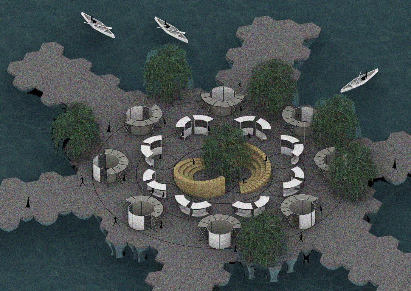
A rehabilitation plan is proposed in the most affected patches of Chinampas to address three primary objectives: water management, mobility, and unification. Strategies include the introduction of biofilters, bioswales, and wetland dynamics to improve water quality, along with redesigning canal systems for enhanced water flow. Mobility enhancements involve increasing connectivity via canals and designing adaptive pedestrian pathways responsive to traffic fluctuations. The unification strategy seeks to reconcile the disjointed relationship between the terrestrial urban fabric and the aquatic chinampa system through an architectural program that integrates market area, traditional agricultural zones, and a Unity Hub, envisioned as a transformational, strengthening Xochimilco’s social cohesion by providing flexible environments that respond to the diverse needs of the community throughout the year through adaptable, modular spaces that support diverse community needs year-round. Its design fosters connectivity, inclusivity, and multifunctionality, offering dynamic spaces for cultural, social, and everyday activities. All of which culminates in an adaptive floating settlement
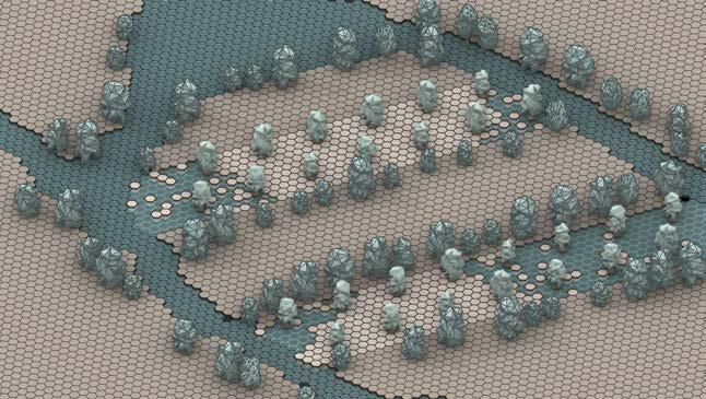
At the regional and local scales, the thesis advances the concept of an adaptive aqua-fabric derived from modular morphologies inspired by the traditional chinampa system. A modern reinvention of chinampas is developed, featuring a modular hexagonal structure constructed from sustainable materials like tezontle, adobe, and volcanic ash. The design incorporates contemporary scientific advancements, such as zeolite and pozzolana for water filtration, oxygenating plants for natural purification, and agricultural platforms to enhance biodiversity and sustainable crop production. The modular system, composed of optimized components, can form various configurations that address environmental, urban, and architectural goals. Its permeable design and strategically adaptive aggregation improve water movement by leveraging convection driven by thermal differentials. This modular design forms the foundation of the proposed urban fabric.
The overarching aim of the thesis is to create a resilient and sustainable urban framework that connects and harmonizes strategically with Xochimilco’s existing water systems and cultural heritage. By blending Indigenous knowledge with modern technology, the study presents a blueprint for urban development that prioritizes ecological restoration, sustainable water management, and community well-being. This approach not only revitalizes the ancient chinampa system but also offers a replicable model for addressing urban and environmental challenges in other contexts.
CHAPTER I
Chapter Overview
The Chinampa system, a remarkable agrarian-water management technique pioneered by the Aztec civilization, once enabled the prosperity of Tenochtitlan through sustainable agricultural practices and urban development. Presently, Xochimilco, the sole surviving remnant of this system, confronts challenges posed by urban encroachment, environmental contamination, and the decline of agricultural traditions, leading to stagnant waterways, ecological decline, and the erosion of cultural identity.
This study investigates pioneering strategies for the restoration of Xochimilco’s Chinampa ecosystem while accommodating contemporary urban requirements. Drawing inspiration from international examples such as the Uros floating islands, Makoko’s elevated settlements, and Kenzo Tange’s conceptualization for Tokyo Bay, the research advocates for adaptive and modular design methodologies. These strategies encompass optimized geometrical configurations and reconfigurable networks aimed at enhancing water governance, biodiversity, and urban interconnectedness.
Framed by inquiries concerning sustainable human practices, adaptability, and the modernization of traditional methodologies, the initiative reconceptualizes the Chinampa system as an integrated aqua-fabric. This strategy seeks to restore ecological equilibrium, safeguard cultural heritage, and provide a paradigm for sustainable urbanism within aquatic contexts.
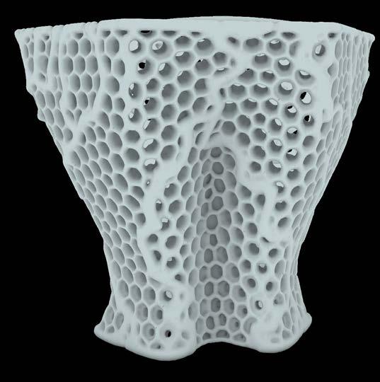
Figure 01. Representative view of Xochimilco’s Aqua-Fabric
1. Symbiosis of Human Systems and Natural Ecosystems
In the year 1325, the basin of the Valley of Mexico contained a central interconnected lacustrine system of five lakes that once hosted a wetland ecosystem. It is in the middle of the shallow waters of the now extinct lake Texcoco where the Aztecs built the capital of their empire: Tenochtitlan, now known as Mexico City. With the rapid expansion of the city and its people, land became scarce, thus Aztecs created the Chinampa system to aid in the growth patterns of their urban fabric. The Chinampa system involved utilizing shallow waters to expand areas of the island for habitation and farming through a land-water management approach. This allowed the gradual expansion of their territory into the surface water, effectively transforming Tenochtitlan into a remarkable “floating city.” These artificial 10th-century A.D. islands not only aided in the growth of urban space but also became the source of agriculture for the city.
With the arrival of the Spaniards, the decision to dry the lakes was made, as the European vision for urban construction did not fit the aqua-fabric system of the Aztec City of Tenochtitlan, seeing that the lakes did not have a natural outlet for water to flow, leading to several floods in the new Spanish city1. With the city’s continuous growth, each lake was dried until only a few were left, Xochimilco or “where the flowers grow” from its Nahuatl original name, is one of them.
1“Chinampas Agriculture and Settlement Patterns.” Circular Water Stories. Accessed March 22, 2024. https://circularwaterstories.org/analysis/chinampas-agriculture-and-settlement-patterns/.
Figure 02. Map of Mexico City where the old lacustrine system is pictured with the borough of Xochimilco highlighted.
1.1. The Chinampa System
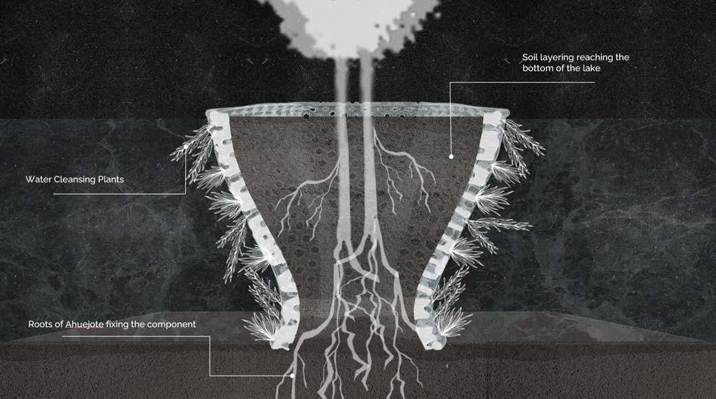
The Chinampas that composed the city, and still used in Xochimilco, create fertile land for farming in shallow lake areas. They consist of artificial islands constructed by staking out plots with wooden poles from the branches of the Ahuejote willow. The space between these posts is filled with layers of mud, lake sediments, and decaying vegetation, creating a fertile base. Once the base is built, the surface is covered with soil, which is often sourced from lake-bed dredging, this adds nutrients to the plot. Eventually the branches of the willow used as poles grow roots and, over time, a full-grown willow emerges stabilizing the chinampa and preventing erosion.
Another variation of fabrication was through rafts constructed from reeds enclosed in rectangular shapes with wattle fencing, which were then layered with biodegradable material in the same manner as previously stated. These rafts were typically constructed in the shallow areas of the lake, afterwards the Aztecs used them as portable land area that they tethered to their canoes, relocating them within the lagoon according to Tenochtitlán’s territorial requirements. When they wanted to fix/anchor this Chinampa variation, they would simply create a foundation for embankment to place the rafts and proceed to plant the Ahuejote willow in the corners and borders, where roots grew securing the chinampa to the lake-bed1. This system allows a highly productive, year-round farming, as the surrounding water provides natural irrigation and nutrient-rich soil. Chinampas played a crucial role in sustaining large populations in the Valley of Mexico, balancing agriculture with water management.
1. Circular Water Stories, “Chinampas: Agriculture and Settlement Patterns,” accessed September 18, 2024, https:// circularwaterstories.org/analysis/chinampas-agriculture-and-settlement-patterns/.
Figure 03. Zoom-in Schematic Map of Xochimilco, Mexico City
Figure 04. Top view (left) and structural section (right) of Xochimilco’s chinampa system.
1.2.The Chinampa System and the Environment: Creators of an Ecosystem
The system not only proved to be effective for the growth of the urban fabric, it also managed to create a symbiotic relationship between nature and human-made construction. Due to this, the Chinampas continue to be utilized sustainably for agriculture; farmers employ roots, lake bottom mud, and organic waste from previous harvests to maintain and expand the Chinampas, utilizing and recycling 100% of the resources from the fields, following the practices of their ancestors. By incorporating organic matter into the construction of the land layers water filtration and absorption is enabled into the upper soil layers, facilitating natural irrigation. Simultaneously, the system aids in water retention by filtering the subsoil, preventing erosion and subsidence.
The chinampas have proven to be a sort of urban “heaven” as stated by author Alejandra Borunda from National Geographic: “The chinampas are by no means “natural.” But they are still a critical part of Mexico City’s environment. Internationally protected as a UNESCO heritage site and valuable wetland, they’re a key stopover for migratory birds and home to many local species. They’re the only place in the wild, for example, to find the critically endangered axolotl, a remarkable amphibian that can regenerate entire limbs with ease and has proven critical to modern medical research. What’s more, the cooling capacity of their network of canals keeps temperatures in check not only in Xochimilco but across the city; estimates suggest losing the wetland zone could drive local temperatures up by several degrees Celsius and cut rainfall by as much as 40 percent.”
Its circular nature offers valuable insights into landscape-oriented approaches to water-dependent cultivation. From this perspective, as well as its sustainable and self-sufficient urban approach, one can delve into the significance of this traditional water system in addressing contemporary challenges.
Figure 05. Schematic section of Xochimilco’s settlement and the canals created as a result of the chinampas
Figures 06 & 07. Plan view (above) and schematic section (below) of Xochimilco’s chinampa aqua-fabric.
2.Threatend Paradise
Today, Xochimilco remains in the southeast of Mexico City with the same chinampa system created in the 13th century, nominated a UNESCO heritage site for its remarkable 100% sustainable system. However, the city is no longer the same; as it reaches its expansion limits, Xochimilco finds itself encroached. This exacerbated growth has led to the arrival of informal housing: historically, the lake extended over 350 square kilometres and contained 170 square kilometres of chinampas, today, only about 25 square kilometres of chinampas remain, indicating that approximately 145 square kilometres have been lost to urbanization in the form of informal housing and other factors. Additionally, it’s estimated that 25% of the remaining chinampa area has been urbanized, with only 17% considered active. This unplanned growth has disrupted the carefully balanced biome of the lake due to the dumping of wastewater into the canals. When the chinampas are urbanized in this manner, their agricultural potential is lost creating “dead” chinampas. To make matters worse, the growth of the city has forced some of the “chinamperos”1 to take on industrialized farming techniques such as the use of pesticides and fertilizers in the crops as means to keep up with the food demands of the population; this adds to the water pollution due to the chinampas’ direct connection with the lake in its intricate natural irrigation system.2
In a very summarized manner, as understood from the interviews to chinamperos and research conducted by UNAM3 , the chain of events are as follows: increased population, leads to a higher demand on food production and housing, this results in increased pressure to the Chinampa system as it is not being able to meet the modern/ higher demands. This results in chinamperos resorting to either the usage pesticides and fertilizers on the chinampa to speed up the production process or the total abandonment of the chinampa. The abandoned chinampas are then targeted for informal housing which, due to poor planning, end up throwing all waste and sewage into the lake. All of this results in the pollution of the overall ecosystem.
3 Imaz Gispert, Mireya, Luis Zambrano González, Juan Ansberto Cruz Gerón, Adriana Martínez, and Luis Gutiérrez. Tech. Análisis Del Estado de Conservación Ecológica Del Sistema Lacustre Chinampero de La Superficie Reconocida Por La UNESCO Como Sitio Patrimonio de La Humanidad En Xochimilco, Tláhuac y Milpa Alta. Mexico City: UNAM, 2014.
Figure 08. Informal housing spreading on the chinampas at Xochimilco (photo by National Geographic)
Figure 09. Schematic diagram illustrating chain of events
Kenzo Tange’s Vision for Tokyo
3. Case Studies
In response to these problems, the research frames the key problematic features by analysing six case studies dealing with water bodies. At the same time, a final site is selected after in-depth observation from a series of representative case studies. By comparing and evaluating seven criteria—urban growth, water management, material, climatic vulnerability, network, biodiversity, and food production—it maps out how multiple facets of floating urban fabrics are interconnected, ranging from urban morphology to ecosystem quality.
In 1960, Kenzo Tange proposed a visionary urban plan for Tokyo Bay to address post-war urbanization challenges like overpopulation, traffic congestion, and housing shortages. Influenced by the Metabolism movement, Tange envisioned cities as adaptable, living organisms capable of growth and expansion over the water.
Figure 10. Selected case studies, located on the world map.
Figure 11. Kenzo Tange’s plan for Tokyo, 1960.
The plan’s core feature was a spinal axis across Tokyo Bay, connecting the city centre to underdeveloped areas. This spine would support a multi-layered grid, replacing traditional two-dimensional zoning with a flexible, three-dimensional system.
In a contemporary context, Tange’s emphasis on flexibility and adaptability in urban design is especially relevant; modern cities face rapid population growth, shifting economic conditions, and unpredictable environmental challenges. Tange’s vision of a dynamic urban fabric, where infrastructure and buildings could evolve and reconfigure over time, offers valuable lessons for today’s urban expansions dealing with water bodies. Though unrealized, Tange’s plan remains a powerful case study in designing cities that can grow sustainably and fluidly, highlighting the importance of flexible infrastructure in shaping future urban landscapes 1
1 Buildings and roads would attach to the spine, allowing the city to grow and adapt over time. However, the proposal raised significant environmental and logistical concerns. Expanding over water posed financial, political, and technical challenges, as well as highlighted the environmental risks of large-scale interventions on natural ecosystems. Alison G. Kwok, “Can We Talk?: Women in the Design Studio,” in Proceedings of the 96th Annual Meeting of the Association of Collegiate Schools of Architecture, March 27-30, 2008, 52-58, https://www.acsa-arch.org/proceedings/Annual%20Meeting%20Proceedings/ACSA. AM.96/ACSA.AM.96.52.pdf.
Figure 12, 13 & 14. Section of Tange’s proposal were flexibility of the aqua-fabric is seen
Ijburg Expansion, Netherlands
The Ijburg expansion in Amsterdam, initiated in the 1990s, addresses land scarcity by creating artificial islands on the IJmeer lakebed to alleviate housing shortages. A notable feature is the inclusion of immovable floating houses, designed for a water-based community. However, their static nature highlights concerns about the lack of adaptability in water-based urban planning, raising questions about the long-term impact on ecological balance and future urban growth amid climate change and increasing urbanization.
Figure 16. Ijburg’s expansion plan, 1997
Figure 17. Section of the Ijburg Expansion, the man-made islands can be appreciated.
Venice, Italy
Venice, a remarkable maritime city, is profoundly shaped by its complex network of canals, which defines its spatial organization, cultural essence, and transportation systems. In this analysis, Venice is examined through four principal dimensions: the durability of construction materials against inundation, erosion, saline degradation, and microbial influence. Furthermore, the city’s foundational architecture and subterranean aquifers are paramount in assessing its durability.
Built on Istrian limestone with brick structures underpinned by wooden piles driven into the lagoon’s clay, the materials of Venice are responsive to environmental pressures. Although some timber, such as alder, is subject to bacterial deterioration, these foundational elements continue to be crucial to the city’s overall structural integrity.1
1 The city’s sewage infrastructure continues to rely on tidal forces to flush waste through the canals, but now incorporates septic tanks and modern sewage treatment systems to limit lagoon contamination. Venice’s urban infrastructure has evolved in a continuous balancing act between preserving its identity and adapting to contemporary environmental pressures. Luigi D’Alpaos and Daniela D’Alpaos, “Flooding Risk of Venice: Influence of Natural and Anthropogenic Land Subsidence and Sea Level Rise,” Geomorphology 376 (2021): 107568, https://doi.org/10.1016/j. geomorph.2021.107568.
Figure 18. Venice’s Urban fabric division.
Figure 19. In the section bellow it is appreciated the intricate well system and foundations used in Venice
Makoko, Nigeria
Makoko, a coastal settlement situated in Lagos, Nigeria, exemplifies a stilted slum atop the Lagos Lagoon, accommodating over 100,000 inhabitants, predominantly from the Egun ethnic group, whose livelihoods are primarily derived from fishing. The settlement is characterized by a deficiency in essential services such as electricity, educational institutions, and waste management systems, with its urban geography intricately molded by its aquatic environment.
1
Dwellings are constructed on stilts or as floating houseboats, utilizing locally harvested bamboo and tropical hardwoods, which exhibit natural water-resistant properties. The spatial organization of the settlement is perpetually in a state of transformation, adapting to fluctuating circumstances as its informal waterways function as vital transportation conduits, illustrating the community’s resilience and innovative strategies in addressing environmental adversities.1
Figure 20. Makoko Floating Settlement
Ola-Dele Kuku, “Environmentally Responsive Design: A Study of Makoko Floating School Building,” Proceedings of the 1st African International Conference on Industrial Engineering and Operations Management, 2019, https://www.researchgate.net/publication/337935560
Figure 21. Makoko’s pile system
Urus Community, Lake Titicaca, Peru
The Uros community residing on Lake Titicaca, a society predating the Inca civilization, serves as a pertinent illustration of human adaptability in harsh ecological conditions. The Uros inhabit floating islands constructed from totora reeds, a renewable and durable resource that is plentiful in the lake. This customary practice, which necessitates continual upkeep due to the decay of the reeds, exemplifies a refined equilibrium of resource utilization and labor efforts.
Their techniques provide significant perspectives on sustainable living practices and adaptive architectural design, standing in stark contrast to contemporary urbanization, which frequently results in environmental pollution and degradation. As global apprehensions regarding climate change intensify, the practices of the Uros accentuate the necessity of incorporating indigenous knowledge into modern approaches for environmental management and water conservation, offering valuable lessons for sustainable solutions applicable at both micro and macro levels 1
Figure 23. Representation of the weaving technique employed by the Urus for the making of the floating islands and their homes.
Figure 22. Urus Floating Settlement
1 Edwin E. Ikhuoria and Kenneth E. Odaro, “Urbanization and Its Implications for Sustainable Development in the Developing Countries,” Proceedings of the World Sustainable Building Conference, 2011, https://www.irbnet.de/daten/ iconda/CIB21650.
Figure 6. Urus Informal Settlement.
24, 25 &
Urus’ dynamic aqua-fabric is explored in these sections, showing how the islands may be moved around as needed.
Figure
26.
3.1. Establishing the Relationships
The examination of five distinct case studies—Makoko, Ijburg, Uros, Tokyo, and Venice—illuminates the unique factors that influence their development and engagement with aquatic ecosystems. Makoko, Ijburg, and Uros are located within lacustrine systems, whereas Tokyo and Venice are positioned in marine environments, which inform their construction methodologies and ecological ramifications.
The capacity for adaptability exhibits considerable variation: Makoko, Ijburg, and Venice depend on fixed infrastructures, Tokyo implements semi-fixed systems, and Uros is characterized by entirely movable floating islands. Construction techniques encompass compacted materials utilized in Ijburg and Venice, stilt-supported structures in Makoko and Tokyo, and woven materials in Uros, illustrating a spectrum of approaches.
Figure 27. Diagram of case studies’ relations
Figure 28,29,30,31. Schematic analysis diagrams of case studies
Material utilization also presents notable differences, as Ijburg, Venice, and Tokyo incorporate synthetic substances that could detrimentally affect ecosystems, while Makoko and Uros utilize organic materials, thereby promoting a more harmonious relationship with the environment. Ecologically, Uros contributes to enhanced biodiversity and food production, whereas Tokyo and Ijburg pose potential threats to local ecosystems.
These case studies exemplify the diverse adaptability, materiality, and ecological strategies inherent in aqua-fabrics, providing valuable insights for the advancement of sustainable water-based urbanism.
3.2. Comparative Evaluation Conclusion
The analysis of five urban settings—Ijburg, Venice, Makoko, Uros, and Kenzo Tange’s concept for Tokyo Bay—yielded significant insights regarding adaptability, reconfigurability, and modularization within the domain of water-based urbanism.
Adaptability demonstrates considerable variability: Makoko employs fixed stilt constructions, Venice depends on static land reclamation strategies, Uros showcases mobile reed islands, Ijburg combines fixed and modular approaches, while Tange’s vision for Tokyo proposes adaptable megastructures that engage with marine contexts.
Reconfigurability is most prominently illustrated in Uros, characterized by modular floating islands, succeeded by Makoko’s expandable stilt frameworks and Ijburg’s phased developmental approach. In contrast, Venice remains unchanged, whereas Tange’s proposal envisions a flexible urban grid capable of expansion or contraction as required.
Modularization spans from Uros’ organic reed constructs to Ijburg’s synthetic segmented communities. Makoko exemplifies incremental adaptability, while Venice is anchored to static compacted landforms. Tange’s Tokyo Bay encompasses modular megastructures designed for scalable, long-term adaptability.
These case studies, alongside Tange’s conceptualization, have informed the thesis by elucidating the equilibrium between flexibility and stability, thus fostering methodologies for resilient aquatic urban systems.
Figure 32,33. Schematic analysis diagrams of case studies
4. Discussion: Research Questions & Proposal
Having understood the history and key features of the Chinampas System, as well as its intrinsic relationship with its ecosystem as well as with the city that surrounds it, understanding its current critical state and incorporating the analysis of various case studies that help the understanding of urban fabrics in bodies of water; this study looks to explores innovative approaches to address the challenges facing the chinampa ecosystem in Xochimilco. By examining the potential of integrated and adaptive systems, the research seeks to balance human activity with environmental preservation, enhance water management, and adapt traditional practices to modern urban demands. The following research questions guide this investigation:
Can the implementation of an integrated network system in Xochimilco promote a balanced human presence by reducing the environmental footprint and enhancing water management to preserve the chinampa ecosystem amidst uncontrolled urban growth?
Can an adaptive & reconfigurable system improve the overall response of the fabric to water management, seasonality and social/cultural fluctuation patterns?
Can the original Chinampa System be adapted to the current urban demands by modifying & optimizing its base geometry?
By integrating into the area, a modified geometrical modular and optimized approach of the chinampa system inspired from the traditional methods, can a network that meets current urban demands be achieved?
To answer these questions, this project aims to use the traditional chinampa system as an area of learning opportunity as well as to redefine it by implementing a new aqua-fabric that may address the water management issues brought by the unplanned urban growth and thus restore the balance of the lake biome. Additionally, it may serve as an experimental opportunity for future urban tissues that may grow on and deal with water bodies.
Figure 34. Air photo of Xochimilco (National Geographic)
Chapter cover image was produced by the team.
Figure 1) Photo sourced from: “Chinampas Agriculture and Settlement Patterns.” Circular Water Stories. Accessed March 22, 2024. https://circularwaterstories.org/analysis/chinampas-agriculture-and-settlement-patterns/.
Figure 2) Map elaborated by the team.
Figure 3) Schematic map elaborated by the team.
Figure 4) Top view and section elaborated by the team.
Figure 5) Schematic section sourced from: “Chinampas Agriculture and Settlement Patterns.” Circular Water Stories. Accessed March 22, 2024. https://circularwaterstories.org/analysis/chinampas-agriculture-and-settlement-patterns/.
Figures 6 & 7) Schematic plan view and section elaborated by the team.
Figure 8) Photograph sourced from: Borunda, Alejandra. “In Mexico City, the Pandemic Revived Aztec-Era Island Farms.” National Geographic Magazine, June 30, 2022. https://www.nationalgeographic.com/magazine/article/in-mexico-city-the-pandemic-revived-aztec-era-island-farms.
Figure 9) Diagram elaborated by the team.
Figures 10-33) All maps and sections have been elaborated by the team.
Figure 34) Photo sourced from: “Chinampas Agriculture and Settlement Patterns.” Circular Water Stories. Accessed March 22, 2024. https://circularwaterstories.org/analysis/chinampas-agriculture-and-settlement-patterns/.
Alvarado, Rocío González. “Canales de Xochimilco, Con Agua Contaminada Y Pestilente.” La Jornada, January 11, 2024. https://www.jornada.com.mx/noticia/2024/01/11/capital/canales-de-xochimilco-con-agua-contaminada-y-pestilente-6155.
Beanland, Chris. “Canned Designs: Tokyo’s Floating City.” The Long and Short, May 10, 2016. https://thelongandshort.org/cities/canned-designs-tokyo-kenzo-tange.
Bennie, Claire. “Amsterdam: Ijburg.” Municipal, February 20, 2024. https://www.wearemunicipal.co.uk/ thinking/amsterdam-ijburg.
Borunda, Alejandra, and César Rodríguez. “In Mexico City, the Pandemic Revived Aztec-Era Island Farms.” Magazine, June 30, 2022. https://www.nationalgeographic.com/magazine/article/ in-mexico-city-the-pandemic-revived-aztec-era-island-farms.
Centre, UNESCO World Heritage. “Historic Centre of Mexico City and Xochimilco.” UNESCO World Heritage Centre. Accessed, 2024. https://whc.unesco.org/en/list/412/.
“Chinampas Agriculture and Settlement Patterns.” Circular Water Stories. Accessed March 22, 2024. https://circularwaterstories.org/analysis/chinampas-agriculture-and-settlement-patterns/.
Coolhuntermx. “Sobre La Importancia Del Agua y La Labor de Chinampas En Xochimilco, Ciudad de México.” ArchDaily México, July 20, 2021. https://www.archdaily.mx/mx/965408/sobre-la-importancia-del-agua-y-la-labor-de-chinampas-en-xochimilco-ciudad-de-mexico.
Crisis ambiental en xochimilco, Espacio Emblemático de ... Accessed July 22, 2024. https://www.insp.mx/ images/stories/Noticias/Salud_Poblacional/Docs/111103_nsp1.pdf.
Delegacionxochi. “La Problemática Del Abastecimiento Del Agua En Xochimilco.” Xochimilco, February 3, 2016. https://delegacionxochi.wixsite.com/xochimilco/single-post/2016/02/02/la-problem%C3%A1tica-del-abastecimiento-del-agua-en-xochimilco.
“Don’t Miss Tomorrow’s Smart Cities Industry News.” Smart Cities Dive. Accessed June 22, 2024. https:// www.smartcitiesdive.com/ex/sustainablecitiescollective/ijburg-amsterdam-innovative-neighborhood-artificial-islands/197746/.
García Navarro, Justo, and Juan Fernando Hidalgo-Cordero. “Review on the Traditional Uses and Potential of Totora ( Schoenoplectus Californicus ) as Construction Material.” Research Gate, October 2017. https://www.researchgate.net/publication/320845489_Review_on_the_Traditional_Uses_and_Potential_of_Totora_Schoenoplectus_Californicus_as_Construction_Material.
“Ijburg Agora.” MVRDV. Accessed June 15, 2024. https://www.mvrdv.com/projects/299/ijburg-agora.
“IJburg, Amsterdam, the Netherlands.” IJburg, Amsterdam, The Netherlands | Urban Green-blue Grids. Accessed June 24, 2024. https://urbangreenbluegrids.com/projects/ijburg-amsterdam-the-netherlands/.
“Ijburg.” archiweb.cz. Accessed June 10, 2024. https://www.archiweb.cz/en/b/ijburg.
Imaz Gispert, Mireya, Luis Zambrano González, Juan Ansberto Cruz Gerón, Adriana Martínez, and Luis Gutiérrez. Tech. Análisis Del Estado de Conservación Ecológica Del Sistema Lacustre Chinampero de La Superficie Reconocida Por La UNESCO Como Sitio Patrimonio de La Humanidad En Xochimilco, Tláhuac y Milpa Alta. Mexico City: UNAM, 2014.
“Lake Titicaca Holidays .” Journey Latin America. Accessed June 17, 2024. https://www.journeylatinamerica.com/destinations/lake-titicaca/.
Lin, Zhongjie. “City on the Move: Mobility, Structure, and Symbolism in Kenzo Tange’s 1960 Plan for Tokyo.” Seeking the City. Accessed June 15, 2024. https://www.acsa-arch.org/proceedings/Annual%20Meeting%20Proceedings/ACSA.AM.96/ACSA.AM.96.52.pdf.
Lorbobby. “Venice, Italy: Rising Sea Levels and Flood Water Management and Mitigation Practices.” URPL 590 – Planning for Resilience to Natural Hazards – Spring 2016, May 2, 2016. https://urpl590resilience. wordpress.com/2016/05/02/venice-italy-rising-sea-levels-and-flood-water-management-and-mitigation-practices/.
“Masterplan Ijburg: Large-Scale Urban Expansion Project on the Outskirts of Amsterdam.” de Architekten Cie., 1999. https://www.cie.nl/page/960/masterplan-ijburg?lang=en.
Ochoa, Danny. “The Uros People of Lake Titicaca.” Peru Hop, September 19, 2024. https://www.peruhop. com/the-uros-people-of-lake-titicaca/.
Ola-Dele Kuku, “Environmentally Responsive Design: A Study of Makoko Floating School Building,” Proceedings of the 1st African International Conference on Industrial Engineering and Operations Management, 2019, https://www.researchgate.net/publication/337935560
“A Plan for Tokyo 1960.” Architecture History.org. Accessed May 30, 2024. http://architecture-history.org/ architects/architects/TANGE/OBJECTS/1960, A Plan for Tokyo 1960, Tokyo, JAPAN.html.
publisher, Josiah LindquistFollow this. “Social Integration in the Public Realm: IJburg, Amsterdam, The Netherlands.” Issuu, July 1, 2021. https://issuu.com/josiahlindquist/docs/master_s_thesis_second_ draft_070121.
Researchgate | find and share research. Accessed January 15, 2025. https://www.researchgate.net/. Rosenberg, Andrew. “Floating Houses in Ijburg / Architectenbureau Marlies Rohmer.” ArchDaily, March 20, 2011. https://www.archdaily.com/120238/floating-houses-in-ijburg-architectenbureau-marlies-rohmer.
Songer, Tristan, and Rebecca Lilliquist. “Transportation & Traffic Control in Venice.” Engineering Rome, September 26, 2022. https://engineeringrome.org/transportation-traffic-control-in-venice/.
Team, ArchEyes. “Kenzo Tange’s Vision for Tokyo in 1960: A Master Plan.” ArchEyes, February 10, 2023. https://archeyes.com/plan-tokyo-1960-kenzo-tange/.
Vaib. “Kenzo Tange - Tokyo Bay Masterplan.” The Design Street, March 5, 2010. https://thedesignstreet. blogspot.com/2010/03/kenzo-tange-tokyo-bay-masterplan.html.
“Venice Spared from Flood Catastrophe Thanks to Engineering Wonder.” DHI, December 8, 2022. https:// www.dhigroup.com/news/venice-spared-from-flood-catastrophe-thanks-to-engineering-wonder.
“Venice’s New Mose Barrier Just Prevented a Historic Flood - the Washington Post.” The Washington Post, November 27, 2022. https://www.washingtonpost.com/climate-solutions/2022/11/26/venice-floods-mose-barrier-climate/.
“Why Does Venice Flood?” Royal Museums Greenwich, 2020. https://www.rmg.co.uk/stories/topics/venice-flooding-climate-change-coastal-cities.
CHAPTER II
Chapter Overview
The methodological framework of this dissertation employed sophisticated computational instruments, algorithms, and empirical methodologies to systematically tackle environmental, spatial, and architectural dilemmas.
Network analysis, incorporating decoding space and shortest path walk algorithms, enhanced spatial connectivity and pedestrian circulation, while the wave function collapse algorithm promoted effective zoning of public, semi-public, and private areas. Computational fluid dynamics (CFD) analysis yielded insights into hydrodynamic behavior and thermal convection, refining interactions within aquatic systems.
An evolutionary algorithm refined morphological design, achieving a balance among structural integrity, environmental responsiveness, and aesthetic considerations. Ladybug tools facilitated environmental evaluations, encompassing solar, wind, and energy assessments, thereby ensuring designs were responsive to climatic conditions. Structural analysis and topological optimization maximized material efficiency and structural stability.
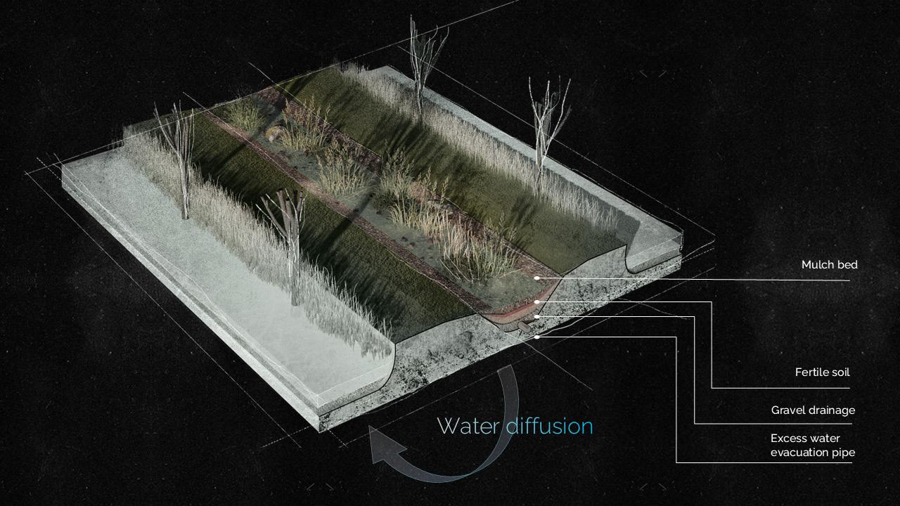
A practical experiment utilizing oxygenator plants illustrated their efficacy in water purification by diminishing chemical pollutants and fostering ecosystem rehabilitation through natural mechanisms such as nutrient uptake and microbial activity.
These integrated methodologies established a comprehensive, data-informed framework that fostered sustainable and innovative architectural solutions for multifaceted project challenges.
Figure 01. Clay printing with robots
Physical Experiment
Water Purification Setup
The water purification device was systematically designed to imitate and amplify the inherent natural processes within the Xochimilco ecosystem, employing aquatic tanks to reproduce the soil-water interactions emblematic of the region. Chinampa soil, a substrate replete with nutrients and historically significant to the lake system of Xochimilco, was integrated into the experimental framework to assess its contribution to natural filtration and ecological dynamics. The aquatic tanks were filled with water derived from Xochimilco’s lake, thereby ensuring that the experimental conditions genuinely reflected the region’s environmental context.
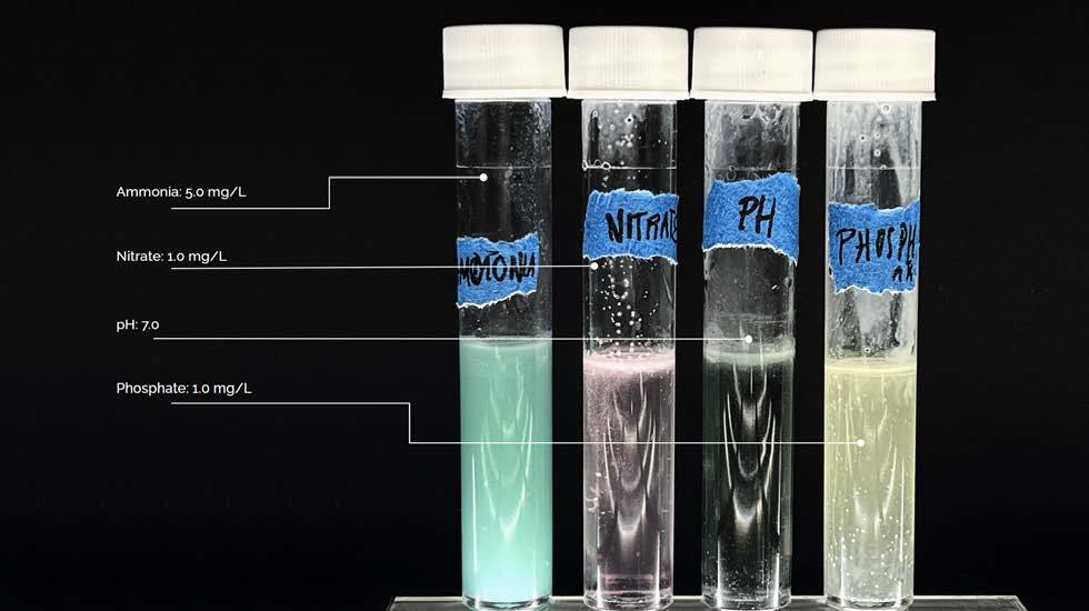
In this configuration, oxygenator plants were introduced into the tanks in conjunction with the chinampa soil to simulate the natural processes of nutrient absorption, nitrification, and microbial activity. The tanks were initially contaminated with pollutants frequently present in Xochimilco’s waters, including nitrates, ammonia, and phosphates, to accurately model real-world scenarios. Over the course of the experiment, the plants facilitated the purification of the water through nutrient uptake and intrinsic biological processes.
Data collected prior to and following the experiment indicated substantial enhancements in water quality, encompassing reductions in nitrate, ammonia, and phosphate concentrations. The synergistic effect of chinampa soil and oxygenator plants demonstrated efficacy in stabilizing pH levels, augmenting microbial activity, and diminishing harmful contaminants, underscoring their potential for scalable implementation in ecosystem restoration and water management within the distinctive environment of Xochimilco.
Morphology Form Finding
Generating Floating and Fixed Morphologies
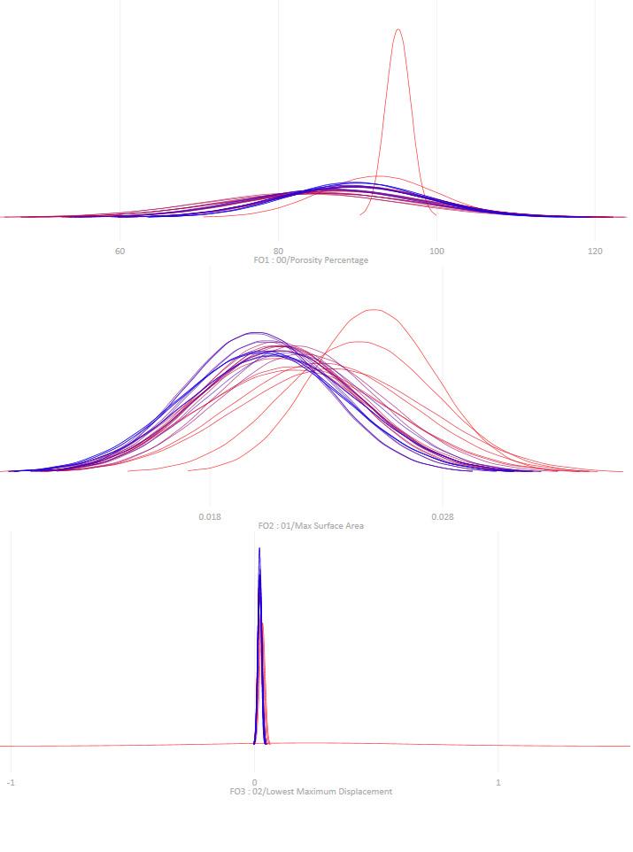
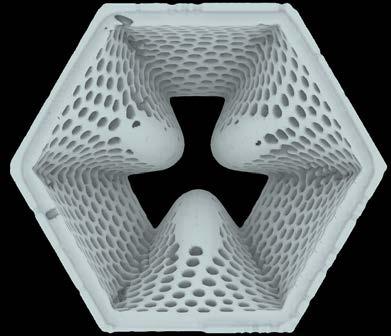
The methodology employed in the exploration of morphology form generation within this project was propelled by computational workflows and analytical techniques that effectively integrated structural and environmental factors. Volumetric components, conceptualized as voxels, were utilized to establish the foundational framework for the design. Finite Element Analysis (FEA) was implemented to refine the proportions of these components, thereby ensuring the structural integrity and buoyancy vital for floating modules.
Buoyancy was integral to the structural efficacy of the morphology. FEA facilitated the assessment of displacement trajectories, load distribution, and resistance to deformation in response to environmental forces such as hydrostatic pressure and dynamic loads. This analytical approach guaranteed that the floating modules could sustain stability and endure external influences while operating efficiently within their aquatic milieu.
An evolutionary algorithm was employed to further enhance the morphology. This optimization framework reconciled various parameters, including structural integrity, hydrodynamic performance, ecological surface area, and buoyancy. The recursive aspect of this approach culminated in a design that is both practical and attuned to ecological requirements.
The ultimate design of the chinampa system resulted from these computational methodologies, ensuring a morphology that aligns structural performance with ecological synergy. The integration of FEA and evolutionary optimization culminated in a solution adept at resisting environmental forces while facilitating an effective and sustainable interface with the aquatic ecosystem.
Figure 02. Process of mimicking the soil type & sediments found in the lake.
Figure 4. FEA Stress analysis
Figure 3. Evolutionary Algorithm
Network Generation
The process of network generation employed advanced computational methodologies to enhance spatial interconnectivity and circulation. The tool Decoding Space was utilized to examine the current network, emphasizing betweenness (which identifies thoroughfares with significant traffic) and closeness (which evaluates proximity to other nodes). This examination pinpointed the most utilized routes, establishing a basis for the formulation of a new, optimized network that incorporated pre-existing connections.
Subsequently, the Shortest Path Algorithm was implemented to fine-tune the new network by determining the most effective pathways between designated attractor points within each zone. These zones—classified as public, semi-public, and private—were delineated based on functional imperatives, with attractor points directing the creation of pathways. This algorithm ensured the minimization of travel distances while improving connectivity throughout the site.
By synthesizing the analysis from Decoding Space and the Shortest Path Algorithm, the resultant network maintained the integrity of the existing structure while introducing efficient, accessible pathways that were specifically designed to meet the zoning requirements and functional objectives of the site.
Zoning
In the context of the zoning process, the Wave Function Collapse (WFC) algorithm was utilized to produce optimized spatial configurations. WFC is a procedural algorithm that operates by disseminating constraints across a grid framework, thereby ensuring that the generated layouts conform to established rules and patterns. This approach guarantees both coherence and functionality while permitting adaptability in spatial arrangement.
Within this initiative, attractor points such as the current market area, pre-existing chinampas, and residential zones were delineated to inform the zoning process. The algorithm leveraged these attractor points to develop zones that achieved a harmonious balance of accessibility, functionality, and spatial coherence.
The implementation of the Wave Function Collapse algorithm facilitated a dynamic and efficient zoning process, resulting in a layout that corresponds with both the functional requirements of the site and the overarching design objectives.
Figure 05. Decoding Spaces
Figure 07. Wave Function Collapse
Environmental Analysis
Solar Analysis:
The environmental assessment engaged the Ladybug plug-in, a highly advanced tool for modeling solar and thermal conditions, targeted at examining solar orientation and radiation changes throughout the year. This analysis pinpointed areas of elevated heat, thereby informing the strategic positioning of market and unity hub modules to facilitate shading. The implementation of shading structures mitigated solar radiation exposure, resulting in a reduction of surface water temperature and instigating thermal convection—where cooler water descends while warmer water ascends—thereby engendering natural water flow.
In addition, new structure and modules were assembled to offer targeted shading, consequently reducing the urban heat island effect and improving thermal dynamics in the canals. These methodologies enhanced water circulation, improved thermal comfort, and optimized overall environmental efficacy.
Wind Analysis:
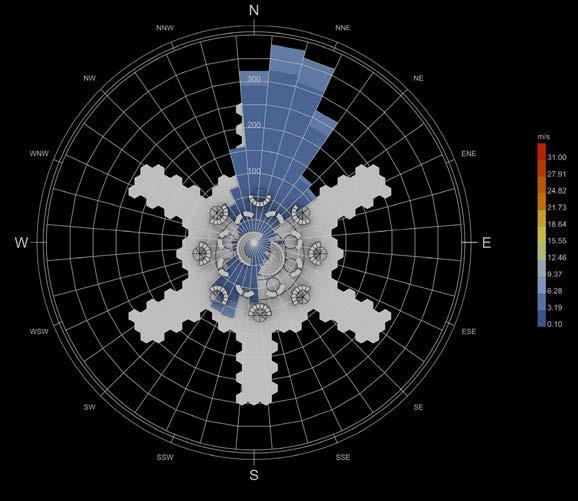
A thorough investigation of wind dynamics was undertaken through the use of the Ladybug plug-in, a complex tool that allows for in-depth simulations of wind behavior and trajectories, focused on improving the architecture of floating modules. This investigation was instrumental in identifying dominant wind directions and velocities across various seasons, thereby ensuring that the design could accommodate environmental fluctuations effectively.
The findings from the wind analysis informed the configuration of the floating modules, establishing pathways that harnessed wind currents to improve ventilation and mitigate heat accumulation. The modules were deliberately arranged to facilitate airflow, thereby enhancing comfort in communal areas and promoting natural cooling mechanisms. By synchronizing the design with the site’s wind patterns, the floating modules were rendered more adaptable and environmentally attuned, thereby augmenting both functionality and ecological sustainability.
Water Flow Analysis:
A thorough investigation into hydrological flow was carried out using the Bison plug-in, an advanced tool developed for the assessment of terrain and water resources, focused on evaluating catchment zones and identifying locations prone to flooding. This examination yielded valuable insights into the dynamics of water movement and accumulation patterns throughout the site, which are essential for formulating efficient water management strategies.
The findings underscored regions at risk of flooding, which were subsequently incorporated into the design of water management systems. The analysis affirmed that the design was aligned with the inherent hydrological properties of the region, thus enhancing both operational efficiency and ecological harmony.
WATER MANAGEMENT/ FLOW
The execution of CFD analysis, a highly developed simulation approach for examining fluid dynamics, aimed to shed light on the mechanisms of water flow and movement within the defined area. This analytical procedure was pivotal in assessing the strategic positioning of biofilters and experimenting with various aggregation methodologies.
The CFD simulations comprehensively investigated the consequences of diverse biofilter aggregation configurations on the creation of tunnel effects and discerned the most proficient arrangement for improving water flow. By modeling water dynamics and flow velocities, the analysis corroborated the ideal positioning of biofilters and aggregation configurations to promote effective water circulation, mitigate stagnation, and enhance overall water management. This methodology offered a data-informed foundation for the formulation of systems that harmoniously integrate ecological and functional objectives.
Figure 09. Ladybug Tool, Solar radiation
Figure10. CFD (computational FLuid Dynamics)
Discussion
The integration of advanced computational tools, ecological assessments, and innovative design frameworks within this initiative highlights a holistic approach to addressing the challenges faced by the aquatic and urban ecosystems of Xochimilco. By harnessing the traditional wisdom inherent in the Chinampa system and utilizing state-of-the-art algorithms such as Wave Function Collapse for zoning and Computational Fluid Dynamics (CFD) analysis for hydrodynamic studies, the project fosters a synergy between ecological restoration and contemporary urban demands.
The incorporation of biofiltration systems, adaptive architectural forms, and environmental evaluations guaranteed designs that are pragmatic, sustainable, and attuned to their contexts. By connecting natural processes with engineered interventions, the proposed methodologies illustrate the feasibility of scalable and adaptable frameworks that not only restore the Xochimilco ecosystem but also provide a replicable paradigm for urban water governance and sustainable development.
Figure 11. Ladybug, Wind Analysis
Chapter Cover Image was produced by the team.
Figure 01) “Ceramic 3D Printing: Clay 3D Printing Simply Explained.” All3DP, June 16, 2023. https://all3dp.com/2/ceramic-3d-printing-clay-simply-explained/.
Figure 02 ) Image taken by the team
Figure 03) “Wallacei.” Food4Rhino, November 30, 2023. https://www.food4rhino.com/en/app/wallacei.
Figure 06) “Shortest Walk Gh.” Food4Rhino, May 17, 2022. https://www.food4rhino.com/en/app/shortest-walk-gh.
Figure 07) R/generative on reddit: Can anyone help me out with my wave function collapse algorithm? Accessed January 10, 2025. https://www.reddit.com/r/generative/comments/17kvyr7/can_anyone_ help_me_out_with_my_wave_function/.
Figure 08) “Ladybug Tools.” Ladybug Tools | Home Page. Accessed January 10, 2025. https://www.ladybug.tools/.
Figure 09) Kaarwan, Team. “Grasshopper for Environmental Analysis in Sustainable Design.” Kaarwan blogs. Accessed January 10, 2025. https://www.kaarwan.com/blog/architecture/environmental-analysis-using-grasshopper-for-sustainable-design?id=1216.
TecnoConverting. “Tecnoconverting CFD Simulation.” TecnoConverting Engineering, February 5, 2024. https://www.tecnoconverting.com/news/tecnoconverting-cfd-simulation/.
Kaarwan, Team. “Grasshopper for Environmental Analysis in Sustainable Design.” Kaarwan blogs. Accessed January 10, 2025. https://www.kaarwan.com/blog/architecture/environmental-analysis-using-grasshopper-for-sustainable-design?id=1216.
R/generative on reddit: Can anyone help me out with my wave function collapse algorithm? Accessed January 10, 2025. https://www.reddit.com/r/generative/comments/17kvyr7/can_anyone_help_me_out_ with_my_wave_function/.
“Shortest Walk Gh.” Food4Rhino, May 17, 2022. https://www.food4rhino.com/en/app/shortest-walk-gh.
“Ladybug Tools.” Ladybug Tools | Home Page. Accessed January 10, 2025. https://www.ladybug.tools/.
“Wallacei.” Food4Rhino, November 30, 2023. https://www.food4rhino.com/en/app/wallacei.
Analysis | Decodingspaces Toolbox. Accessed January 10, 2025. https://toolbox.decodingspaces.net/ category/analysis/.
CHAPTER III RESEARCH DEVELOPMENT
Chapter Overview
This chapter presents a thorough investigation into water management methodologies designed to confront the urgent issues afflicting the aquatic ecosystem of Xochimilco. Nestled within a distinctive urban and ecological context, the lake system of Xochimilco grapples with challenges such as water contamination, stagnation, and excessive aquifer depletion, all intensified by unregulated urban expansion and the deterioration of its traditional chinampa agricultural practices. These challenges not only threaten the ecological integrity of the lake but also jeopardize its cultural heritage and the economic stability of local populations.
By conducting an in-depth analysis of fluid dynamics alongside innovative water management strategies, the chapter investigates the potential for integrating natural and engineered solutions to rejuvenate the ecological vitality of the lake. Fundamental strategies encompass the deployment of bioswales to promote aquifer recharge, the utilization of biofilters for the elimination of pollutants, and the integration of oxygenating flora to enhance and stabilize water quality. Furthermore, the chapter scrutinizes the efficacy of convection-driven water circulation and aeration systems in mitigating stagnation and nurturing a harmonious aquatic ecosystem.
The outcomes derived from these investigations, bolstered by empirical experiments, yield essential insights for the formulation of sustainable water management frameworks for Xochimilco.
Figure 01. Representative view of Xochimilco Lake
1. Site & Contextual Analysis
This section focuses on on-site analysis and synthesizing the challenges and problematic zones within the context. First, the site would be analyzed environmentally by inputting the collected data in the related digital workflows. The site boundary would be divided into pixels with specific dimensions. Eventually, three zones will be selected according to the three main defined challenges in the context of the water.
Location & Extent of the Study Area
Xochimilco is located in the southern part of Mexico City, Mexico, with it coordinates at 19.2629° N latitude and 99.1049° W longitude. It is situated within the municipality of Xochimilco, one of the 16 administrative divisions of the capital city. Xochimilco lies approximately 28 kilometers (17 miles) south of the historic center of Mexico City and covers an area of approximately 125 square kilometers (48 square miles), however the area of major interest for the purposes of this study lays within the defined “patrimonial area” constituting a surface of 80 km21.The patrimonial area is divided into three zones or neighborhoods: Ejidos de Xochimilco or Xochimilco, San Gregorio de Atlapulco, and San Luis Tlaxialtemalco; all of these still have canals and chinampas containing 2,824 active chinampas out of 18,524.
1 Alberto González Pozo et al., “Chapter I: Panorama Introductorio,” essay, in Las Chinampas: Patrimonio Mundial de La Ciudad de México, ed. Fernando R. Chiapa Sánchez, 1st ed. (Mexico City: Universidad Autónoma de México (UAM), 2016), 21.
Figure 02. Location of the borough of Xochimilco in Mexico City
I. 2. Mobility
Network Analysis (Decoding Space)
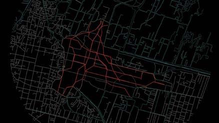
Network analysis of the pedestrian networks and canals in Xochimilco was performed using spatial network metrics together with decoding space analysis to explore patterns of connection and spatial behaviour. It is used betweenness and closeness centrality indexes to determine the relative importance and availability of individual nodes and connections on the network. Betweenness centrality revealed the most common corridors and canals that served as the most significant connections, those infrastructure pieces that would receive most traffic and contribute to network cohesion. Closeness centrality gave an index of reach, recognising nodes that make it shortest to travel between them, and are centers for fast movement within the network.
Added to that was decoding space analysis to make sense of spatial relations, uncovering hidden structures and hierarchies that influence movement and connectivity 1
1The schematic network analysis shows the betweenness value for the water canals/bodies. The green color indicates a low passage along the canal, while yellow and red colors show medium and high levels of passages, respectively
This hybrid method provided a deeper understanding of how Xochimilco organised itself spatially, by unveiling both explicit and implicit modes of pedestrian and canal use. The interpretation focused on physical circulation and their functional functions, but also on the spatial syntax of human relations with the built and natural world.
Figure 03. Map of existing water bodies/canals (left) and the schematic network analysis of it (right).
Figure 04. Transportation through the canals is done in long canoes, there exist small amount of pedestrian or car roads. (Photo from National Geographic)
1.3. Chinampas
As mentioned in the Domain Chapter, chinampas are artificial islands closely manicured to produce various vegetables, flowers, and medicinal plants that are placed inside a lake creating canals as they are placed.
1 Pie de Página, “Las Chinampas Sobreviven Rodeadas Por Amenazas,” Pie de Página, September 19, 2024, https://piedepagina.mx/las-chinampas-sobreviven-rodeadas-por-amenazas/. Research Development
Active & Inactive Chinampas
To further understand the existing network and eventually create design solutions, chinampas are catalogued as stated in the published book by UAM University were chinampas are analyzed and categorized with collaboration of the Mexican government . The cataloging is as follows:
Active Chinampas
Active chinampas are farmed plots closely manicured to produce various vegetables, flowers, and medicinal plants. The distinguishing features of an active chinampa are:
Simple Cultivation: Farmers plant, tend, and harvest crops regularly throughout the year using traditional farming methods passed down over generations.
Irrigation Management: These chinampas are supplied by well-maintained canals that provide them with enough water for irrigation, and the canals themselves act as natural filtration systems to replenish their soil.
Biodiversity: Maintained chinampas support a large and diverse range of plant species, which, in turn, support many insect and animal species, helping to maintain the area’s overall ecological health.
Inactive Chinampas
However, recently abandoned chinampas have been plots once under agricultural production that have fallen out of use for diverse factors such as urbanization, contamination, or economic change. Inactive chinampas are those plots that include evidence of abandonment, Therefore, the unused canals surrounding abandoned chinampas get silted up or polluted, preventing the existence of a functioning irrigation system and degrading the chinampa and the water’s quality. In their inactive state, chinampas can become dangerous hotspots of pollution and habitat degradation, and restoration— removing weeds, opening canals, and reintroducing native species—requires a great deal of labor. It’s estimated that 25% of the remaining chinampa area has been urbanized, with only 17% considered active1.
Figure 05. Map in which the Chinampa “islands” are highlighted in green
Figure 06. Map depicting active chinampas (green) and inactive chinampas (red)
Active Chinampas in a Decaying State
Within the previously highlighted chinampas in an active/productive state, exists a sub-category in which chinampas continue to be utilized for agricultural purposes, however, due to diverse problems such as economic difficulties from scarce agricultural demand in the area, water pollution and loss of the Ahuejote willows, some chinampas are categorized as under “decaying state”. These areas should be rehabilitated as to not lose the original chinampas, their rehabilitation highly depends on the water quality of the canals due to their direct connection, seeing that once the chinampa is submerged in the lake it creates a natural irrigation system1, thus their “healthy” state depends on the water as well as on how much the chinampa is worked upon, thus increasing demand for agricultural produce from Xochimilco might also prove effective.
1 Circular Water Stories, “Chinampas: Agriculture and Settlement Patterns,” accessed September 18, 2024, https://circularwaterstories.org/analysis/chinampas-agriculture-and-settlement-patterns/.
Chinampas Lost to Informal Housing
According to UAM researcher Alberto González, of the 17,336 agricultural chinampas that existed in 1936, 3,586 remain, less than 20 percent, “and 3.69 km2, 16.7 percent of the 22.15 km2 of former chinampa areas have been lost”1 to urbanization in the form of informal housing and the trend continues to expand2. Wastewater coming from the informal housing and from “smaller treatment plants within a 12-mile radius are discharged into the canals at an alarming rate of 2,000 liters per second, she says. It’s enough to fill an 8-foot deep pool measuring 2.5 feet by 2 feet every second”3, says Refugio Rodriguez Vázquez, a biotechnology professor at Mexico’s National Polytechnic Institute, who has studied the wetland since 2016.
The informal housing growth is noticed in the south border of the Xochimilco lake, where the end of the aqua-fabric clashes with the terrestrial fabric; this can imply that the expansion of terrestrial urbanization is encroaching upon the delicate balance of the chinampa system, a traditional agricultural method sustained by the aqua-fabric. This clash highlights the lack of integration between the two fabrics—one rooted in water-based agricultural practices and the other in terrestrial urban development. The absence of interaction or synergy between these fabrics fosters a sense of disconnection, where the communities in each fabric remain isolated and socially differentiated.
This dis-junction is not merely a spatial issue but also a socio-economic and cultural one. The terrestrial fabric, characterized by informal housing, often overrides the aqua-fabric, exerting pressure on the chinamperos (farmers of the chinampa system). This dynamic not only limits the ability of chinamperos to sustain their livelihoods but also jeopardizes the survival of the chinampa system—a cornerstone of cultural heritage and ecological balance in Xochimilco.
1 Iván Sosa, “Disminuyen Chinampas En Xochimilco Por Urbanización,” REFORMA, December 11, 2022, https://www.reforma.com/disminuyen-chinampas-en-xochimilco-por-urbanizacion/ar2519376.
2 Pie de Página, “Las Chinampas Sobreviven Rodeadas Por Amenazas,” Pie de Página, September 19, 2024, https://piedepagina.mx/las-chinampas-sobreviven-rodeadas-por-amenazas/.
3 Sarah Freeman, “This Fragile Wetland Is Dying. Tour Boats Could Be Its Unlikely Savior.,” Travel, January 25, 2022, https://www.nationalgeographic.com/travel/article/nanobubbles-tour-boats-could-rescue-endangered-mexican-wetland.
Figure 07. Map in which the decaying chinampas are highlighted in red
Figure 08. Map showcasing the lost chinampas to informal housing (highlighted in dark blue)
Assessing Water Quality and Management Practices on Site
It is crucial to remember, as stated in the detailed study analysis by UNAM’s (Universidad Nacional Autónoma de México) Ecological Restauration Department1, that Xochimilco is a lake born in the basin formed by the mountains of the Valley of Mexico, thus the canal system that is seen today is merely a result of the aggregation of Chinampas inside the lake itself, with this in mind, the following analysis is conducted.
1 Imaz Gispert, Mireya, Luis Zambrano González, Juan Ansberto Cruz Gerón, Adriana Martínez, and Luis Gutiérrez. Tech. Análisis Del Estado de Conservación Ecológica Del Sistema Lacustre Chinampero de La Superficie Reconocida Por La UNESCO Como Sitio Patrimonio de La Humanidad En Xochimilco, Tláhuac y Milpa Alta. Mexico City: UNAM, 2014.
Canal Network System
The canal system of Xochimilco constitutes an integral part of the region’s hydrology and ecology. In the chinampa area there is a wide canal network made up of main canals, acalotes (canal for canoe navigation), and apantles (irrigation canals), with an extension of 406 km in length, which articulates the circulation of water for chinampa agricultural activity. Canals have an average depth of 1.90 meters where 2.00 meters is the maximum depth and 0.60 the minimum recorded.
As seen in UAM’ s documentation1, canals can be divided in two zones: Zone I consists of canals that are created from the traditional aggregation manner of chinampas where they maintain their original slim yet long dimensions and are placed one after the other creating a dense canal network, these canals are appreciated on the east side in San Gregorio Atlapulco. Zone II is characterized by conserving major canals losing a good part of the “fine” canal network (the acalotes or narrow apantles accessible only to small work boats) since it is conformed of large islets inside of which there are remains of chinampas. This is seen more in the west side, where the neighborhood of Xochimilco is.
Figure 11. Topography of the Mexican Valley with the basin and the lacustrine system in its center.
Figure 09. Map of original lacustrine system with Xochimilco highlighted in white.
Figure 10. Map with topography of the original Xochimico lake.
1 Alberto González Pozo et al., “Chapter II: Catalogación de Zonas Chinamperas,” essay, in Las Chinampas: Patrimonio Mundial de La Ciudad de México, ed. Fernando R. Chiapa Sánchez, 1st ed. (Mexico City: Universidad Autónoma de México (UAM), 2016), 64.
Figure 12. Map of canal system highlighted in blue
This proves relevant as further studies of the canals demonstrate different behaviors of water movement due to their sizes and connectivity. The canals are also divided into navigable, obstructed, blocked, and dried states. The results can be seen in the following maps collected from UAM’s study1:
By comparing these two maps, it is seen that Zone I, which has a denser aggregation of canals, has a less navigable network also seeing a higher number of dried canals, state that is not detected in Zone II; this may become instrumental when designing a new network and connection system in the study area, avoiding the creation of dysfunctional canals due to improper aggregation of chinampas resulting in a complex network lacking of connectivity.
1 Alberto González Pozo et al., “Chapter II: Catalogación de Zonas Chinamperas,” essay, in Las Chinampas: Patrimonio Mundial de La Ciudad de México, ed. Fernando R. Chiapa Sánchez, 1st ed. (Mexico City: Universidad Autónoma de México (UAM), 2016), 64.
Figure 13. Map showing the state of the canals in Zone I.
Figure 14. Map showing the state of the canals in Zone II.
Water Inlets and Outlets
The water inlets that feed the lake can be divided seasonally into dry and rainy seasons. During the rainy season, the lake receives its water from the drainage brought by the mountains in the south, this mainly occurs through the months of May through October, being July to September the ones with heavier rainfall 1
1 Instituto Nacional de Estadística y Geografía. INEGI, National Institute of Statistics and Geography (INEGI), accessed November, 2024, https://en.www.inegi.org.mx/.
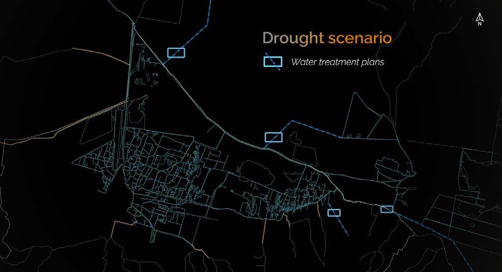
However, during the dry seasons, the lake receives water inputs from a treated wastewater pipeline. The lake mainly receives this water during periods of low rain, thus having a low water level (“estiaje” in Spanish). This season usually covers December through May. The water received during these periods is from wastewater treatment plants. There are other areas that “re-pump” the water from these plants so that it may expand over the tissue effectively. This promotes diversified farming and maintains water levels preventing desiccation and guaranteeing constant hydration of the chinampas1.
Natural inlets injecting water on the south used to bring fresh rainwater from the slopes of the mountains, yet with the growth of the city, the skirts of these mountains are now filled with settlements which pollute the water as it passes through, thus when the water reaches the lake it has carried out pollutants and sediments that decrease the water quality of the lake. This is another situation that must be addressed.
1 Imaz Gispert, Mireya, Luis
Juan
Adriana
and Luis
Tech. Análisis Del Estado de Conservación Ecológica Del Sistema Lacustre Chinampero de La Superficie Reconocida Por La UNESCO Como Sitio Patrimonio de La Humanidad En Xochimilco, Tláhuac y Milpa Alta. Mexico City: UNAM, 2014. 8-18.
Figure 15. Map of natural water inlets on the south border.
Figure 16. Map of water treatment plant locations and their inlets to the site on the north border.
Zambrano González,
Ansberto Cruz Gerón,
Martínez,
Gutiérrez.
Water Inlets and Outlets
One of the parameters that affect this system is the velocity of the water, which modulates the transport of sediments and nutrients and contributes to the proper functioning of the entire aquatic ecosystem of this network. In the following section, a general Computational Fluid Dynamics (CFD) analysis of the canal network was collected from the documentation of UNAM’s (Universidad Nacional Autónoma de México) Ecological Restauration Department1 where a detailed analysis of the site’s water management and quality was performed. In addition, the team performed its own CFD analysis on the natural inlets of the south border to further understand the velocity and the movement of water of the canals at this point before spreading into the overall network.
1 Imaz Gispert, Mireya, Luis Zambrano González, Juan Ansberto Cruz Gerón, Adriana Martínez, and Luis Gutiérrez. Tech. Análisis Del Estado de Conservación Ecológica Del Sistema Lacustre Chinampero de La Superficie Reconocida Por La UNESCO Como Sitio
As stated by UNAM’S report: “it is seen that the highest velocities, occur at the entry sites & decrease significantly in the so-called canal system, with velocities of 36 cm per hour, which is interpretated as meaning that the system operates more like a lagoon system than a canal system”1
Patrimonio de La Humanidad En Xochimilco, Tláhuac y Milpa Alta. Mexico City: UNAM, 2014.
Figure 18. CFD analysis of two natrual water inlets of the south border
Figure 17. CFD performed of the overall canal system seen on site. CFD performed by UNAM University.
This information is crucial in understanding the fluid dynamics occurring in the network. The CFD simulations performed with Sim Scale1 for two of the site’s inlets, give the resulting graphs indicating the lack of water flow as it distances from these initial inlets. The lake is also not connected to fast moving bodies of water such as rivers that could give constant flow and movement to the canals, the system depends on the inlets that result from the natural drainage of the surrounding mountains, thus the low velocity values. To enhance the comprehension of water velocities and dynamics in the canals, three typologies of chinampas creating canals are analyzed.
The CFD simulation done on the three canal typologies demonstrate the highest velocity value oscillating between 4.012e-4 and 7.28e-4 meters per second, this very low flow value can be explained due to the fact that the network is not made of canals that then give place to the chinampas, it is the other way around, the canals result from the placement of the chinampas placed in the lake; roughly said, chinampas are blocks of soil that when placed in the lake block the passage of water and the natural movement brought by flow patterns in a lake.
Chinampas are not exactly porous, they are more like sponges that absorb water, which works perfectly for its own passive irrigation purposes yet not for allowing a flow which supports the constant movement of water in the system in general. This leads to stagnation of water, blockages of channels and even the drying of these (as previously mentioned). To make sure of this theory, the CFD simulations were calibrated with materiality of the blocks representing the chinampas emulating their porosity, permeability, density and thermal conductivity, as well as the site’s environmental factors such as solar radiation and water temperature, data which was sourced from UNAM’s2 and UAM’s3 documentations.
Velocity helps prevent stagnation; the lower the flow of water, the more potential there is for the pollution to stay and develop in the water: “with no movement and aeration, stagnant water becomes a prime breeding ground for biofilms, or a collection of bacteria or fungi. Left untreated, stagnant water often becomes home for dangerous diseases and pathogens”4 . Therefore, the form finding or network generation processes, would also have to increase water movement aided through the understanding of fluid dynamics.
1 A third-party software, not-integrated in Grasshopper that is used for various purposes regarding the Computational Fluid Dynamic (CFD) analysis.
2 Imaz Gispert, Mireya, Luis Zambrano González, Juan Ansberto Cruz Gerón, Adriana Martínez, and Luis Gutiérrez. Tech. Análisis Del Estado de Conservación Ecológica Del Sistema Lacustre Chinampero de La Superficie Reconocida Por La UNESCO Como Sitio Patrimonio de La Humanidad En Xochimilco, Tláhuac y Milpa Alta. Mexico City: UNAM, 2014. 22
3 Imaz Gispert, Mireya, Luis Zambrano González, Juan Ansberto Cruz Gerón, Adriana Martínez, and Luis Gutiérrez. Tech. Análisis Del Estado de Conservación Ecológica Del Sistema Lacustre Chinampero de La Superficie Reconocida Por La UNESCO Como Sitio Patrimonio de La Humanidad En Xochimilco, Tláhuac y Milpa Alta. Mexico City: UNAM, 2014.
4 Jonathan Zinser, “Mitigating Stagnant Water Diseases and Damage during the Pandemic ,” Mitigating Stagnant Water Diseases and Damage During the Pandemic , August 10, 2021, https:// www.rochestermidland.com/watermanagementblog/stagnant-water-during-the-pandemic#:~:text=With%20no%20movement%20and%20aeration,E.
19. CFD analysis of the three main canal typologies that can be found on site
Figure
Linear Typology
“T” Typology
“L” Typology
To understand areas prone to flooding a Slope Drainage Analysis was conducted in grasshopper; this allows to simulate water flow over a slope using topographic, soil, and hydrological data where areas of water accumulation and poor drainage can be identified as a result. These zones, where runoff exceeds the terrain’s drainage capacity, are marked as flood-prone; the analysis highlights regions at risk of surface flooding during heavy rainfall, aiding in effective flood mitigation and planning. The final data collected from the simulation was cross-referenced with INEGI (National Institute of Statistics and Geography)1 were maps pin pointing flood-prone areas were accessed.
1 Instituto Nacional de Estadística y Geografía. INEGI, National Institute of Statistics and Geography (INEGI), accessed November, 2024, https://en.www.inegi.org.mx/.
Figures 20 & 21. Conducted Slope Drainage Simulation on the city’s topography highlighting the site in red (right). Height map highlighting the topology of the terrain (left)
Figure 22. Resulting map of flood-prone locations from Slope Drainage Simulation.
Loss of the Aquifers
Mexico City faces a severe water shortage due to rapid urbanization, population growth, and reliance on over-extraction of underground aquifers. “Currently, more than half the water for the central city comes from its aquifer. Less than half of what is extracted annually is replenished, according to the local government, and that over-exploitation has caused the city – built on a former lake-bed – to sink unevenly.”1
The excessive withdrawal of groundwater has caused significant land subsidence, with the city sinking at alarming rates. This problem is particularly evident in the canals of Xochimilco; the canals are hydrologically connected to the aquifer beneath them. When the aquifer is over extracted, groundwater levels drop, reducing the natural pressure that helps maintain water levels in the canals2. This causes water from the canals to seep downward, further lowering their levels. The dropped levels promote water stagnation, furthering the polluted state of the water, and, over time, the canals dry up as the aquifer fails to sustain the necessary balance.
1 Christine Murray, “This Is How Mexico City Is Tackling Its Water Challenges,” Global Center on Adaptation, January 18, 2021, https://gca.org/this-is-how-mexico-city-is-tackling-its-water-challenges/#:~:text=%E2%80%9CIf%20the%20problems%20remain%2C%20the,of%20water%2C%E2%80%9D%20he%20said.
2 Jeannie Evers, ed., “Water Tables and Aquifers,” Education, October 2024, https://education.nationalgeographic.org/ resource/water-tables-and-aquifers/.
Figure 23. Fixing a hole in the canal bed near the Embarcadero Zacapa as a result of aquifer exploitation.
Credit: Adriana Zehbrauskas for The New York Time
Figure 24.Thermal map showing the sunken areas of Mexico City based on inches/year from October 2014 to May 2015
Figure 25. Diagrams representing the lowering of the water table due to over-extraction of the aquifers, resulting in the lowering of the ground level (in the case of Xochimilco, lowering of the lake-bed).
1.5. Discussion and Site Selection
The previous site analysis not only sheds light on the location and general aspects of the urban fabric in question, but also allows us to understand the fragile situation facing the Xochimilco aqua-fabric and its chinampa system. Situations that give rise to the main problems are identified:
Low network mobility: the canal network creates a complex pattern that does not help connect key points for the people of Xochimilco, specifically for the chinamperos who see the sale of their products affected by not having easy and quick access to the primary roads to be able to distribute their product to the rest of the city or get it to local markets,
Urban growth, loss of chinampas and water pollution: The largest contributing factor to the loss of chinampas is the informal growth of housing, which has taken over 3.69 km2 (16.7 %) of the original chinampa area. Many of these houses are built on chinampas, but since they are not worked for agriculture, they “die” becoming simple blocks of earth. In addition, these houses, by not having planned drainage, discharge all the drainage into the lake, thus contaminating its waters. Disarticulation on the southern edge: Runoff and pollution accessing the network through the inlet areas contributing to the overall pollution levels
Low water movement and flow: The collected CFD analysis on the overall network proved that the system works more like a lagoon than a canal network due to its low velocity index. Performed CFDs on inlet areas showed that water entering the canals begins to decrease speed as it moves away from the source. In turn, the CFDs developed for different types of canals resulting from the positioning of the chinampas showed that the low level of permeability of the chinampa does not allow a constant movement of water since it is trapped in the narrow canals. Loss of aquifers: over-extraction of these causes the low water level of the lake and its canals, promoting stagnation and greater water contamination.
These will be the points that will be addressed for the development of the rehabilitation plan for Xochimilco. To develop this plan, an area was selected where these problems are more marked. Starting with the strip where informal growth abounds, the selected site is located in the Ejidos de Xochimilco area, on the west side of the municipality, since it has the largest number of chinampas lost to informal growth, as well as the largest number of inactive chinampas, unlike the San Gregorio area, which has the largest number of agricultural producing chinampas. The site, measuring approximately 1,172,754 m2, will remove the “dead” chinampas due to urbanization, thus having a piece of the lake with a pure expanse of water in order to integrate a modern morphology of the chinampa seeking to improve water management as well as urban social connections and agricultural production. The chosen site will also serve as a test ground to potentially continue expanding over the entire strip of lost chinampas.
These will be the points that will be addressed for the development of the rehabilitation plan for Xochimilco. To develop this plan, an area was selected where these problems are more marked. Starting with the strip where informal growth abounds, the selected site is located in the Ejidos de Xochimilco area, on the west side of the municipality, since it has the largest number of chinampas lost to informal growth, as well as the largest number of inactive chinampas, unlike the San Gregorio area, which has the largest number of agricultural producing chinampas. The site, measuring approximately 1,172,754 m2, will remove the “dead” chinampas due to urbanization, thus having a piece of the lake with a pure expanse of water in order to integrate a modern morphology of the chinampa seeking to improve water management as well as urban social connections and agricultural production. The chosen site will also serve as a test ground to potentially continue expanding over the entire strip of lost chinampas.
Figure 27. Map highlighting the selected site whithin the “problematic patch”. Figure 26. Map highlighting the “problematic patch” where the informal housing continues to grow.
2. Water Management Logic and Techniques
To understand the techniques that may be applied on the selected site for efficient water management several topics and techniques are explored, beginning with the research for understanding of fluid dynamics and finalizing in a micro scale of a physical experimentation of water purification achieved with local oxygenating plants as well as oxygenating machine.
Understanding Fluid Dynamics
Fluid dynamics examines how fluids like water move, with flow types and heat transfer playing a central role in shaping movement. Understanding these principles helps identify the most efficient method for increasing water circulation in a body of water. Water moves in four primary ways1:
1. Convection: Driven by thermodynamics, this process uses temperature differences to create movement. Warmer, less dense water rises, while cooler, denser water sinks, generating continuous circulation.
2. Laminar Flow: Smooth and orderly, but limited in energy and reach, making it inefficient for large-scale water movement.
3. Turbulent Flow: Chaotic and energetic, but less predictable and harder to control, often requiring significant external forces to maintain.
4. Transitional Flow: A combination of the two, which can be unstable and situationally dependent.
Among these, convection stands out as a highly effective mechanism for increasing water movement. It harnesses natural temperature gradients to create flow without requiring excessive energy input or complex mechanical systems.
Thermodynamics influences water movement even in large bodies of water like oceans. A prime example is the global thermohaline circulation (also called the “ocean conveyor belt”). This system is driven by temperature and salinity gradients: warm surface water near the equator moves poleward, where it cools, becomes denser, and sinks to form deep ocean currents. These currents, in turn, carry cold water back to the equator, creating a continuous cycle that transports heat, nutrients, and carbon dioxide across the globe.
When aiming to enhance water movement, using convection imitates these natural processes on a smaller scale. By strategically introducing temperature differences—such as localized heating or cooling zones—it is possible to create sustainable, efficient water circulation in bodies of water such as lakes, drawing inspiration from the natural forces that drive ocean currents.
1 “Fluid Dynamics 101: Basics to Understanding How Fluids Flow,” Electricsolenoidvalves.com, June 11, 2024, https:// www.electricsolenoidvalves.com/blog/fluid-dynamics-101-basics-to-understanding-how-fluids-flow/?srsltid=AfmBOop_ tUYJoDBNzyLWtrz4V7LHLNmM_DN1ZeWPeWk9YCdec_uqVomS.
2.1.
Figure 28. Map showcasing ocean current movements, case of fluid dynamics.
Bioswales are a water management technique which consists of engineered green infrastructure systems designed to manage stormwater runoff by using vegetation, soil, and permeable materials to filter, absorb, and slow down water flow. Bioswales naturally filter water to replenish aquifers by mimicking the earth’s natural infiltration process. As stormwater flows into a bioswale, vegetation slows it down, allowing sediments and pollutants to settle. The water then percolates through layers of soil and gravel, where microorganisms break down contaminants. This clean water seeps into the ground, recharging aquifers and maintaining the water table. The key parts of the system are as follows:
1. Inlet Zone: Captures and directs water into the system.
2. Vegetation Layer: Plants like grasses and native species slow water flow and remove pollutants.
3. Soil Media: Specially designed soil promotes infiltration and filters contaminants.
4. Drainage Layer: Ensures proper water flow while supporting aquifer recharge.
5. Outlet Zone: Returns filtered water to waterways or storage areas.
Two main types can be identified:
• Dry Bioswales: Designed for quick infiltration, suitable for areas with high groundwater recharge needs.
• Wet Bioswales: Accommodates slower infiltration, ideal for areas prone to frequent flooding.
In flood-prone areas of Xochimilco, bioswales can manage excess rainfall while replenishing aquifers. By strategically placing bioswales along lake perimeters and near canals stormwater can be captured and filtered through vegetation and soil, pollutants are removed, preventing contamination of the lake, the infiltration replenishes the aquifer, raising the water table, thus the healthy water levels in the aquifer can sustain the lake and canals. This system could support sustainable water management, mitigates flood risks, and helps restore Xochimilco’s ecological balance and water-dependent agricultural systems.
2.2. Bioswales
Figure 29. Diagram of bioswales representing their flow and filtration.
Figure 30. Diagram of bioswales and its parts.
Biofilters
Biofilters are the second water management technique that is explored as it has currently been employed in the site with positive outcomes. This system is designed to remove contaminants from water using natural biological processes. They consist of three main components: a filter medium (e.g., gravel, sand, or a floating matrix), a microbial community that breaks down pollutants, and vegetation, which absorbs nutrients and provides habitat for microbes. Within the water biofilters two types were explored due to their applicability to lakes systems:
1. Constructed Wetlands: Engineered ecosystems that mimic natural wetlands. These can be:
• Subsurface flow wetlands: Water flows beneath the surface through a medium, allowing microbes and plant roots to treat contaminants.
• Surface flow wetlands: Water flows over the surface, where plants and microbes remove pollutants.
2. Floating Treatment Units (FTUs)1: Floating platforms with aquatic plants whose roots hang into the water. These systems foster microbial activity and plant uptake of nutrients, improve oxygenation, and help stabilize sediments.
In Xochimilco, biofilters are used to address water pollution and eutrophication caused by agricultural runoff, untreated wastewater, and sediment accumulation. The Chinampa Refloated Project integrates floating wetlands into the lake system. The floating wetlands, constructed using biodegradable platforms, support native vegetation such as tule (bulrush). The plant roots dangle in the water, where they absorb excess nutrients like nitrogen and phosphorus, provide habitat for microorganisms that degrade organic pollutants, trap sediments and reduce turbidity, improving water clarity. Constructed Wetlands alongside, edge-based wetlands have been installed to treat inflowing agricultural runoff and urban wastewater. These wetlands use layers of gravel and soil planted with native species to filter water before it enters the canals. 2.3.
1 “Duwamish Floating Wetlands,” Living Shorelines, 2020, https:// livingshorelines.be.uw.edu/about-us/project-background/floating-wetlands-project/.
One specific successful implementation is in the San Gregorio area of Xochimilco, where floating biofilters have been deployed to mitigate algae growth and improve water quality. These systems have significantly reduced nutrient concentrations in the water, curbing eutrophication and helping preserve the lake’s ecosystem. The initiative also revitalizes biodiversity by creating habitats for aquatic species and birds.
By integrating this water purification technique, Xochimilco not only combats pollution but also preserves its ecological and cultural heritage, supporting sustainable use for agriculture and tourism. The project will seek the implementation of these to further aid in the health of the water system by healthy management techniques.
Figure 31. Diagram of floating biofilter showing the parts that conform it.
Figure 32. (Top)
Photo of existing floating biofilter case study, named Olive by David Pagan Butler.
Figure 33. (Bottom) photo of floating treatment wetland case study by Carolina Clear.
2.4. Water Purification and Oxygenation
Seeking to mitigate the levels of water pollution seen in the system, implementing water purification strategies such as the use of local oxygenating plants can prove to be a good extra feature to include in the design of the morphologies as well as in the design of the biofilter. To assess the efficacy of oxygenating plants in purifying polluted water, an experiment was conducted using three different species known for their water-cleaning properties as well as their local availability on site. The objective was to determine how these plants could affect various water quality parameters over time, specifically in a recreated environment that mirrors the conditions of the Xochimilco polluted lake.
Experiment Methodology
The experiment began with the recreation of the polluted water found in the lake, modelled after the contamination levels reported in a detailed study by UNAM’s (Universidad Nacional Autónoma de México) Ecological Restauration Department1 UNAM’s Report divided the lake by zones, in the study it was evident that the most polluted areas are located in zone B and C, thus these were the chosen levels to replicate; this involved replicating the specific concentrations of pollutants, including nitrites, nitrates, ammonium, phosphates, as well as the pH levels and temperature observed in the actual lake.
UNAM states in the report that the “dissolved oxygen levels are higher than 4 mg/L in all zones, with zones A and F reaching the highest levels. The monitored channels are mainly primary channels that are very long and wide, which allows the action of the wind as a promoter of oxygenation of the water column. Zone A, on the other hand, includes considerably wide channels such as the Tlilac lagoon, the Virgen lagoon, and Paso del Águila, through which trajineras and motorized canoes continually pass, contributing to the increase in oxygenation levels.” This information will later be used in addition to the experiment in which oxygenating machines are used in combination to the plants to test whether the polluted water is cleaned faster.
Tláhuac y Milpa Alta. Mexico City: UNAM, 2014.
1 Imaz Gispert, Mireya, Luis Zambrano González, Juan Ansberto Cruz Gerón, Adriana Martínez, and Luis Gutiérrez. Tech. Análisis Del Estado de Conservación Ecológica Del Sistema Lacustre Chinampero de La Superficie Reconocida Por La UNESCO Como Sitio Patrimonio de La Humanidad En Xochimilco,
Figure 34. The map highlights the zones in which UNAM divided the site to study its water quality. The lake is divided into A, B, C, D, E, and F.
Figure 37. The graphs above show the recorded nitrate levels in various zones of the Xochimilco lake.
Figure 35. The graph above show the recorded temperature levels in various zones of the Xochimilco lake.
Figure 39. The graphs above show the recorded ammonium levels in various zones of the Xochimilco lake.
Figure 38. The graphs above show the recorded oxygen levels in various zones of the Xochimilco lake.
Figure 36. The graphs above show the recorded pH levels in various zones of the Xochimilco lake.
Figure 40. The graphs above show the recorded phosphate levels in various zones of the Xochimilco lake.
Experiment Procedure
To Replicate the water polluted levels chemicals such as pesticides and plant fertilzers were used, these are also some of the main pollutants found in the lake, as stated in UNAM’s Report: “regarding the nutrient levels (ammonium, nitrates and phosphates), these showed a strong influence from human activities and different land uses. Phosphates showed high values typical of hypereutrophic systems (> 0.1 mg/L). All zones presented values higher than 1 mg/L except for zone F, which is practically isolated from the rest of the system, not being associated with any type of agricultural activity nor exhibiting influence from urban discharges. These results indicate that contamination by fertilizers in the lake system is high.”1
Other than mimicking the water conditions of the lake of Xochimilco, additionally, soil and sediment samples were also recreated according to the soil typology found in the lake, this to further simulate the natural environment in which these plants would operate.
Eventually, some of the pesticides and fertilizers were measured to mimic the pollutant levels. (Figure 45) Then, three types of oxygenating plants were selected for this study, each known for their potential to improve water quality. The plants were introduced into the recreated polluted water environment, where they were allowed to acclimate and begin their natural purification processes. (Figure 46)
1 Imaz Gispert, Mireya, Luis Zambrano González, Juan Ansberto Cruz Gerón, Adriana Martínez, and Luis Gutiérrez. Tech. Análisis Del Estado de Conservación Ecológica Del Sistema Lacustre Chinampero de La Superficie Reconocida Por La UNESCO Como Sitio Patrimonio de La Humanidad En Xochimilco, Tláhuac y Milpa Alta. Mexico City: UNAM, 2014.
Figure 41. From left to right, Water Lettuce, Salvinia Natans, and Elodea Densa as the locally accessible plants used in water purification experiment
Figure 42. Chemical variables getting measured to mimic the polluted water quality.
Figure 43. Chemical variables getting measured to mimic the polluted water quality.
As a first step, the plants are introduced in the tank with clean water and the mimicked sediments and left to acclimate for several hours. Once the acclimation period is over, 750 ml of purely polluted water is introduced to the tank holding the plants and the sediments.
Figure 44, 45 & 46. Process of mimicking the soil type of sediments found in the lake.
Figure 47 & 48. The process of mimicking the polluted water quality in the sample fish tank
To monitor the effectiveness of the plants, water quality testing was performed at regular intervals using a comprehensive water testing kit. The kit measured levels of nitrite, nitrate, ammonium, dissolved oxygen, pH, and phosphate. These parameters are critical indicators of water health and are particularly relevant in evaluating the success of the plants in reducing pollution.
Experiment Results
Over the course of the experiment, the water quality showed notable improvement across most parameters. Specifically:
IV.III.I. Ammonium, and Phosphate Levels: These levels steadily decreased over time, indicating that the oxygenating plants were actively absorbing these compounds or facilitating their breakdown in the water.
IV.III.II. Dissolved Oxygen: The oxygen levels in the water increased, suggesting that the plants were effectively oxygenating the environment, which is crucial for sustaining aquatic life and promoting the breakdown of organic pollutants.
IV.III.III. pH Levels: The pH of the water gradually stabilized within a more neutral range, which is beneficial for the overall health of the aquatic ecosystem.
Figure 49. Collected and measured chemical samples at the start of the experiment, values were kept as a reference to compare upon throughout the experiment.
Figure 50. Collected and measured chemical samples during test.taking period of the experiment.
Figure 51. The table depicts the taken samples of the water in the sample tanks, showcasing the results of the conducted experiment.
However, one exception to this trend was observed with the nitrate and nitrite levels, which did not decrease as expected. This suggests that while the plants were effective in reducing other forms chemical compounds, nitrites and nitrates either persisted in the environment or were not sufficiently absorbed by the plants. This could be due to various factors, such as the type of plants used, the specific environmental conditions, or the rate of nitrate uptake by the plants.
The figure below demonstrates, visually understandable, the changes in the water over time, showing after 20 days the comparison between the control group and the tank where the plants were introduced in which it is visibly seen that the water has cleared up drastically. (Figure 52). The persistent nitrate and nitrite levels highlight a limitation in the purification capabilities of the selected plants. Further research could explore additional plant species or complementary purification methods to address this gap and optimize the overall effectiveness of such natural water treatment systems.
Figure 53. The sample tank photographed after 15 days of inputting the purifying plants (right) and the polluted water control group (left) used as a comparison point.
Figure 52. The graph shows the mapped results of the samples taken from tanks throughout the experiment.
Figure 54. The sample tank photographed after 15 days of inputting the purifying plants showcasing clear water.
To further study the potential of cleansing polluted water, the experiment was carried out in the exact manner in a new tank, adding sediments, repeating pollution levels, placing oxygenating plants yet adding a tank oxygenating machine (aerator) to asses if by increasing the dissolved oxygen levels in water and enhancing the water’s circulation, the oxygenation process would indirectly support water cleansing by fostering the growth of beneficial microorganisms and preventing harmful conditions like stagnation. The following was documented:
The experiment results showcased an improvement in the water’s pollution levels, seeing the toxins decrease and the oxygen levels increase as the ten days of test taking passed. These results An effectively sustain the hypothesis that constant water movement prevents stagnation and promotes the cleansing of polluted water. By continuously circulating the water, the aerator prevents the formation of anaerobic zones, where harmful bacteria thrive in low-oxygen conditions. The movement also facilitates oxygen diffusion, supporting aerobic microorganisms that break down organic pollutants into less harmful substances. Additionally, circulation disrupts the settling of debris and nutrients that could fuel algae growth, maintaining a balanced ecosystem. This controlled setup highlights how continuous movement and oxygenation are critical for water purification, even in larger-scale environments. Research Development
Introduction of Aerator
Figure 57. The table shows the mapped results of the samples taken from tanks throughout the experiment.
Figure 55 & 56. The sample tank and the aerator being introduced.
Figure 58. The graph shows the mapped results of the samples taken from tank throughout the experiment.
3. Discussion
In conclusion, this chapter has explored the fundamentals of fluid dynamics, emphasizing how thermodynamics can facilitate water movement through convection, alongside innovative water management techniques such as bioswales for aquifer replenishment and biofilters and the incorporation of oxygenator plants for water purification. The successful experiment with oxygenating plants and aerators demonstrated the effectiveness of combining water movement and purification strategies to mitigate polluted water levels. These findings not only reinforce the importance of integrating natural processes into water management systems but also serve as a foundation for the next chapter. Building on this research, the upcoming section will focus on applying these insights to develop design techniques aimed at improving water quality and management in the Lake of Xochimilco. By leveraging the synergy of natural and engineered solutions, this study aims to contribute to the preservation and restoration of this vital aquatic ecosystem.
Figure 59. Watter lettuce photographed from above.
Figure 60. Photograph of Elodea Densa one of the three types of plants in the experiment
Chapter Cover Image was produced by the team.
Figure 01) Image produced by the team.
Figure 02) Map produced by the team.
Figure 03) Maps and analysis produced by the team.
Figure 04) Photo sourced in: National Geographic Magazine, June 30, 2022. https://www.nationalgeographic.com/magazine/article/in-mexico-city-the-pandemic-revived-aztec-era-island-farms.
Figure 05-09) Maps produced by the team.
Figure 10) Map sourced from: Narro Robles, Dr. José, Mireya Imaz Gispert, Luis Ansberto Cruz González, Adriana Mártinez, and Luis Gutiérrez. “Análisis Del Estado de Conservación Ecológica Del Sistema Lacustre Chinampero de La Superficie Reconocida Por La UNESCO Como Sitio Patrimonio de La Humanidad En Xochimilco, Tláhuac y Milpa Alta.” Mexico City: Universidad Autónomma de México, May 2014.
Figure 11) 3D map sourced from: López Espinosa, Erika, and Ángel Ruiz-Alguno. “Estimación de La Respuesta Térmica de La Cuenca Lacustre Del Valle de México En El Siglo XVI: Un Experimento Numérico.” Research Gate, August 2015. https://www.researchgate.net/publication/282661068_Estimacion_de_la_ respuesta_termica_de_la_cuenca_lacustre_del_Valle_de_Mexico_en_el_siglo_XVI_un_experimento_numerico.
Figure 12) Map produced by the team.
Figure 13 & 14) Map sourced from: Narro Robles, Dr. José, Mireya Imaz Gispert, Luis Ansberto Cruz González, Adriana Mártinez, and Luis Gutiérrez. “Análisis Del Estado de Conservación Ecológica Del Sistema Lacustre Chinampero de La Superficie Reconocida Por La UNESCO Como Sitio Patrimonio de La Humanidad En Xochimilco, Tláhuac y Milpa Alta.” Mexico City: Universidad Autónomma de México, May 2014.
Figure 15 &16) Maps produced by the team.
Figure 17) Base map elaborated by the team and overlapped with CFD analysis sourced from: Narro Robles, Dr. José, Mireya Imaz Gispert, Luis Ansberto Cruz González, Adriana Mártinez, and Luis Gutiérrez. “Análisis Del Estado de Conservación Ecológica Del Sistema Lacustre Chinampero de La Superficie Reconocida Por La UNESCO Como Sitio Patrimonio de La Humanidad En Xochimilco, Tláhuac y Milpa Alta.” Mexico City: Universidad Autónomma de México, May 2014.
Figure 18) CFD analysis developed by the team using the Simscale plataform.
Figure 19) CFD analysis developed by the team using the Simscale plataform.
Figure 20 & 21) Maps and analysis developed by the team.
Figure 22) Map developed by the team.
Figure 23) Image sourced from: Burnett, Victoria. “An Aquatic Paradise in Mexico, Pushed to the Edge of Extinction.” The New York Times, February 22, 2017. https://www.nytimes.com/2017/02/22/world/americas/mexico-city-canals-xochimilco-chinampas.html.
Figure 24 & 25) Map and diagrams sourced from: Kimmelman, Michael. “Mexico City, Parched and Sinking, Faces a Water Crisis.” The New York Times, February 17, 2017. https://www.nytimes.com/interactive/2017/02/17/world/americas/mexico-city-sinking.html.
Figure 32) Image sourced from: Butler, David Pagan. “Olive: The World’s First Organic Pools Floating Biofilter.” YouTube, 2017. https://www.youtube.com/watch?v=tGApFkkVHeU.
Figure 33) Image sourced from: Carolina Clear. “Installation of a Floating Treatment Wetland.” YouTube, 2017. https://www.youtube.com/watch?v=eqGbzNbXkBY&t=141s.
Figures 34-40) Image and graphs sourced from: Narro Robles, Dr. José, Mireya Imaz Gispert, Luis Ansberto Cruz González, Adriana Mártinez, and Luis Gutiérrez. “Análisis Del Estado de Conservación Ecológica Del Sistema Lacustre Chinampero de La Superficie Reconocida Por La UNESCO Como Sitio Patrimonio de La Humanidad En Xochimilco, Tláhuac y Milpa Alta.” Mexico City: Universidad Autónomma de México, May 2014.
Figures 41-60) Images, graphs and tables produced by the team during the experiment trial.
Borunda, Alejandra. “In Mexico City, the Pandemic Revived Aztec-Era Island Farms.” National Geographic Magazine, June 30, 2022. https://www.nationalgeographic.com/magazine/article/in-mexico-city-thepandemic-revived-aztec-era-island-farms.
Burnett, Victoria. “An Aquatic Paradise in Mexico, Pushed to the Edge of Extinction.” The New York Times, February 22, 2017. https://www.nytimes.com/2017/02/22/world/americas/mexico-city-canals-xochimilco-chinampas.html.
Butler, David Pagan. “Olive: The World’s First Organic Pools Floating Biofilter.” YouTube, 2017. https:// www.youtube.com/watch?v=tGApFkkVHeU.
Carolina Clear. “Installation of a Floating Treatment Wetland.” YouTube, 2017. https://www.youtube. com/watch?v=eqGbzNbXkBY&t=141s.
Centre, UNESCO World Heritage. “Historic Centre of Mexico City and Xochimilco.” UNESCO World Heritage Centre. Accessed September 17, 2024. https://whc.unesco.org/en/list/412/.
“Chinampas Agriculture and Settlement Patterns.” Circular Water Stories. Accessed March 22, 2024. https://circularwaterstories.org/analysis/chinampas-agriculture-and-settlement-patterns/.
Coolhuntermx. “Sobre La Importancia Del Agua y La Labor de Chinampas En Xochimilco, Ciudad de México.” ArchDaily México, July 20, 2021. https://www.archdaily.mx/mx/965408/sobre-la-importancia-del-agua-y-la-labor-de-chinampas-en-xochimilco-ciudad-de-mexico.
Crisis ambiental en xochimilco, Espacio Emblemático de ... Accessed July 22, 2024. https://www.insp. mx/images/stories/Noticias/Salud_Poblacional/Docs/111103_nsp1.pdf.
Delegacionxochi. “La Problemática Del Abastecimiento Del Agua En Xochimilco.” xochimilco, February 3, 2016. https://delegacionxochi.wixsite.com/xochimilco/single-post/2016/02/02/la-problem%C3%A1tica-del-abastecimiento-del-agua-en-xochimilco.
“Detail : Www.Fao.Org.” FAO. Accessed September 17, 2024. https://www.fao.org/agroecology/database/detail/en/c/1257453/.
Dirección General de Repositorios Universitarios, Universidad Nacional Autónoma de México. “Repositorio Institucional de La UNAM.” Ir al inicio. Accessed July 22, 2024. https://repositorio.unam.mx/.
“Duwamish Floating Wetlands.” Living Shorelines, 2020. https://livingshorelines.be.uw.edu/about-us/ project-background/floating-wetlands-project/.
“El Diccionario de Mejicanismos (1959) de Francisco Javier Santamaría (1889-1963). Un Estudio de Historiografía Lexicográfica : Lucía González Gallardo : Free Download, Borrow, and Streaming.”
Internet Archive, January 1, 1970. https://archive.org/details/mejicanismos.
Evers, Jeannie, ed. “Water Tables and Aquifers.” Education, October 2024. https://education.nationalgeographic.org/resource/water-tables-and-aquifers/.
“Fluid Dynamics 101: Basics to Understanding How Fluids Flow.” Electricsolenoidvalves.com, June 11, 2024. https://www.electricsolenoidvalves.com/blog/fluid-dynamics-101-basics-to-understanding-how-fluids-flow/?srsltid=AfmBOop_tUYJoDBNzyLWtrz4V7LHLNmM_DN1ZeWPeWk9YCdec_ uqVomS.
Freeman, Sarah. “This Fragile Wetland Is Dying. Tour Boats Could Be Its Unlikely Savior.” Travel, January 25, 2022. https://www.nationalgeographic.com/travel/article/nanobubbles-tour-boats-could-rescue-endangered-mexican-wetland.
Research Development
“Félix Candela, El Español Que Puso Curvas a La Arquitectura En México.” El Universal, September 27, 2020. https://www.eluniversal.com.mx/opinion/mochilazo-en-el-tiempo/el-espanol-que-puso-curvas-la-arquitectura-en-mexico/.
González Pozo, Alberto, José Gabriel Castro Garza, Benigno Ángeles Escamilla, Manuel Montaño Pedraza, and Mereguildo Toledo Esteban. “Chapter II: Catalogación de Zonas Chinamperas.” Essay. In Las Chinampas: Patrimonio Mundiao de La Ciudad de México, edited by Fernando R. Chiapa Sánchez, 1st ed., 70–118. Mexico City: Universidad Autónoma de México (UAM), 2016.
Groundwater utilization and sustainability, sustainability of groundwater, sustainable yield of groundwater, sustainable groundwater development, Victor Miguel Ponce. Accessed January 4, 2025. https:// ponce.sdsu.edu/groundwater_utilization_and_sustainability.html.
INEGI. Accessed July 22, 2024. https://www.inegi.org.mx/contenidos/productos/prod_serv/contenidos/ espanol/bvinegi/productos/nueva_estruc/702825191160.pdf.
Instituto Nacional de Estadística y Geografía. INEGI. National Institute of Statistics and Geography (INEGI). Accessed July 22, 2024. https://en.www.inegi.org.mx/.
Kimmelman, Michael. “Mexico City, Parched and Sinking, Faces a Water Crisis.” The New York Times, February 17, 2017. https://www.nytimes.com/interactive/2017/02/17/world/americas/mexico-city-sinking. html.
López Espinosa, Erika, and Ángel Ruiz-Alguno. “Estimación de La Respuesta Térmica de La Cuenca Lacustre Del Valle de México En El Siglo XVI: Un Experimento Numérico.” Research Gate, August 2015. https://www.researchgate.net/publication/282661068_Estimacion_de_la_respuesta_termica_de_la_ cuenca_lacustre_del_Valle_de_Mexico_en_el_siglo_XVI_un_experimento_numerico.
Murray, Christine. “This Is How Mexico City Is Tackling Its Water Challenges.” Global Center on Adaptation, January 18, 2021. https://gca.org/this-is-how-mexico-city-is-tackling-its-water-challenges/#:~:text=%E2%80%9CIf%20the%20problems%20remain%2C%20the,of%20water%2C%E2%80%9D%20 he%20said.
Narro Robles, Dr. José, Mireya Imaz Gispert, Luis Ansberto Cruz González, Adriana Mártinez, and Luis Gutiérrez. “Análisis Del Estado de Conservación Ecológica Del Sistema Lacustre Chinampero de La Superficie Reconocida Por La UNESCO Como Sitio Patrimonio de La Humanidad En Xochimilco, Tláhuac y Milpa Alta.” Mexico City: Universidad Autónomma de México, May 2014.
“Patterns in Nature: The Efficiency of Hexagons.” letting nature back in, October 29, 2020. https://naturebackin.com/2020/10/29/patterns-in-nature-the-efficiency-of-hexagons/.
Pie de Página. “Las Chinampas Sobreviven Rodeadas Por Amenazas.” Pie de Página, September 19, 2024. https://piedepagina.mx/las-chinampas-sobreviven-rodeadas-por-amenazas/.
“Poca y de Mala Calidad El Agua En Xochimilco.” Aunam Noticias. Accessed July 22, 2024. https://aunamnoticias.blogspot.com/2022/03/poca-y-de-mala-calidad-el-agua-en.html.
Resilientemagazine. “Ríos y Canales En La CDMX: Un Pasado Lacustre Entubado.” Resiliente Magazine, June 3, 2022. https://resilientemagazine.com/rios-y-canales-en-la-cdmx-un-pasado-lacustre-entubado/.
Rey-Hernández, Catalina. “Chinampas Agriculture and Settlement Patterns: The Contemporary Relevance of Aztec Floating Gradens.” View of chinampas agriculture and settlement patterns: The contemporary relevance of Aztec Floating Gardens, February 9, 2022. https://bluepapers.nl/index.php/bp/ article/view/32/32.
Soleri, Paolo. “Arcology.” The Library. Accessed April 26, 2024. https://www.organism.earth/library/document/arcology.
Sosa, Iván. “Disminuyen Chinampas En Xochimilco Por Urbanización.” REFORMA, December 11, 2022. https://www.reforma.com/disminuyen-chinampas-en-xochimilco-por-urbanizacion/ar2519376.
Taubman College of Architecture and Urban PlanningFollow this publisher. “Mud: Mexico - Xochimilco.” Issuu, March 16, 2016. https://issuu.com/taubmancollege/docs/mudmexico-xochimilco.
Thompson, Andy. “Earth’s Oceans.” Environmental Science & Engineering: Physical Oceanography at Caltech. Accessed November 16, 2024. https://web.gps.caltech.edu/~andrewt/EarthsOceans2019. html.
UT College of Architecture and DesignFollow this publisher. “Low Impact Development: Opportunities for the Planet Region.” Issuu, September 25, 2013. https://issuu.com/utkcoad/docs/2013_0807_-_ lid_opportunitiesfor_t/149?epik=dj0yJnU9TTJwdW9aUWh2OWE0T0xSMC1xYnA0Wm9DM3NJUDdqY2YmcD0wJm49c0dqbnpMbE9DXzZLT3FWN1BYSjNQQSZ0PUFBQUFBR2RfNXc4.
Wade, David. Li: Dynamic form in nature. Glastonbury: Wooden Books, 2007. Wirth, Louis. “Urbanism as a Way of Life.” The University of Chicago Press. Accessed April 26, 2024. https://www.sjsu.edu/people/saul.cohn/courses/city/s0/27681191Wirth.pdf.
“Xochimilco.” Encyclopædia Britannica. Accessed March 22, 2024. https://www.britannica.com/place/ Xochimilco.
“Xochimilco: Un Oasis En La Ciudad de México.” Este País, July 14, 2021. https://estepais.com/impreso/ numero-359-abril-de-2021/xochimilco-un-oasis-en-la-ciudad-de-mexico/#_ftn4.
Zawarus, Phil, and Justin Allen. “Low Impact Development: Opportunities for the Planet Region.” Issu, September 25, 2013. https://issuu.com/utkcoad/docs/2013_0807_-_lid_opportunities_for_t/149?epik=dj0yJnU9TTJwdW9aUWh2OWE0T0xSMC1xYnA0Wm9DM3NJUDdqY2YmcD0wJm49c0dqbnpMbE9DXzZLT3FWN1BYSjNQQSZ0PUFBQUFBR2RfNXc4.
Zinser, Jonathan. “Mitigating Stagnant Water Diseases and Damage during the Pandemic .” Mitigating Stagnant Water Diseases and Damage During the Pandemic , August 10, 2021. https://www.rochestermidland.com/watermanagementblog/stagnant-water-during-the-pandemic#:~:text=With%20no%20 movement%20and%20aeration,E.
CHAPTER IV DESIGN DEVELOPMENT
Chapter Overview
The design development phase emphasizes the incorporation of ecological, social, and urban factors to restore the aquatic and terrestrial ecosystems of Xochimilco. This initiative re-envisions the chinampa system via adaptive morphologies, pioneering water management techniques, and computational methodologies, tackling challenges such as contamination, stagnation, and urban sprawl.
At the core of the strategy lies the establishment of a multifunctional framework that harmonizes traditional chinampa practices with contemporary needs. The design employs computational techniques, including the Wave Function Collapse Algorithm, for zoning and connectivity, thereby optimizing land utilization while safeguarding cultural and ecological values. Mobility networks were enhanced through the application of shortest-path algorithms, facilitating uninterrupted connectivity among critical areas such as agriculture, markets, and residential zones.
The morphology of the chinampas integrates tessellated hexagonal modules to achieve a balance of porosity, buoyancy, and adaptability. Computational and structural enhancements refine the design, facilitating improved water circulation and the incorporation of ecological processes such as filtration and oxygenation. Furthermore, the implementation of biofilters and funnel-like aggregations mitigates the impact of polluted water entering through natural inlets, ensuring efficient purification and water movement.
Figure 01. Zoom-in of the mesh of one of the achieved morphologies.
1. Design Strategy
Currently Xochimilco has re-habilitation projects utilizing biofilters as water cleansing practices, yet the purifying systems are not enough, as long as the urban fabric continues to grow unplanned, polluting, the situation will be an endless cycle, perhaps the re-habilitation strategy must turn to address the overall water management and urban planning of the overall fabric.
The project will center on the re-habilitation of the agricultural chinampa system in the strip that were the aqua-fabric clashes with the terrestrial fabric. The re-habilitation would cover a 40-year period addressing the lost chinampa areas by designing and incorporating a re-understood chinampa morphology and system that can adapt to the modern strains and demands. The first period of this plan is addressed in this paper, delving directly with water management, mobility and weaving the two fabrics in the “problematic” strip answering to architectural programming such as farming cooperatives to boost the agricultural practices as well as social/cultural unification. These points are achieved by a combination of the chinampa re-design and its adaptive aggregation towards the site’s environmental conditions, creating a positive effect of water management, mobility and fabric weaving. The following flowchart illustrates the design strategy:
Figure 02. Diagram depicting the design stratergy discussed above.
The design starts by approaching the site on an urban scale by creating a zoning that will lead the placement of the chinampas as well as the generation of the mobility network. The zoning is created by utilizing Wave Function Collapse Algorithm1 (WFC); this allows a controlled result by defining rules for how buildings, streets, and spaces should connect (e.g., a road must meet another road), WFC allows generation of urban fabrics that are both functional and diverse. It ensures design coherence while allowing for creative variations, making it a powerful tool for computational urban planning.
1 The Wave Function Collapse (WFC) algorithm is a computational method inspired by quantum mechanics. It works by selecting and arranging small building blocks (like tiles or patterns) according to rules of compatibility, similar to solving a jigsaw puzzle. The “collapse” happens when choices for a block become limited, and a decision is made, which then affects the options for neighbouring blocks.
The Monoceros plug-in for Grasshopper was utilized to carry the WFC; the plug-in works with voxels in which a module is encapsulated, each face of the voxel must have a defined rule for aggregation so that the algorithm knows where to create connections and where to avoid them. The rules and zoning are as follows:
•The market area looks to promote the selling of produce by strategically connecting These may connect to agricultural, canal and to unity-hub areas, yet connection to housing is disallowed.
•The unity-hub becomes the most crucial area of the zoning as it becomes the connecting point between all the zones and between the terrestrial urban fabric that is located on the southern edge, creating a space of social union as well as fostering farmer cooperative areas that seek to facilitate agricultural production, as well as the distribution of their products from the agricultural area to the market area. In turn, it functions as a buffer between the housing zone and the agricultural areas. Thus, it may create connections with all areas.
•Agriculture zoning looks to ensure traditional agriculture as well as the safeguarding of these areas, thus the rules prioritize their connection to canals and to the unity-hub areas where the farmer cooperative resides.
•Wetlands (area for bioswales development) can only be aggregated on the site’s border where attractor points were defined from the flood-prone analysis realized on the previous chapter.
•Housing1 connection to the unity-hub and to the canals is allowed, yet connection to agriculture areas is disallowed.
Additionally, a rule for aggregation based on attractor points was added to create a zoning that would respond to the surrounding existing areas at the boundaries of the project’s site, ensuring proper integration; agricultural areas have attractor points on the north as the traditional agriculture chinampas are found there, the market attractor point is located to west of the site as there the local municipality market is found on the terrestrial urban fabric, the housing areas also respond to attractor points placed on housing areas of the surrounding border.
Finally, a boundary condition was established, it may only be assembled of canals for ensuring the connection to existing canals or with wetland/bioswales, the latter is then aggregated based on attractor points of the found flood-prone areas.
1 The developing of a design for the housing will not be covered in this phase of the re-habilitation plan as water management, weaving between fabrics and agriculture have a preference, yet for the future phases of development of this plan well planned housing would prove crucial to enhance a well-rounded urban design whilst creating a proper sewage and disposal strategies that currently create pollution in the area.
Figure 03. Diagram explaining the rule logic for aggregation of the Wave Function Collapse Algorithm in the Monoceros plug-in for Grasshopper.
2.2. Iterations
The following images present the iterations that were ran before reaching the final zoning. Every time an iteration was ran the rules were changed and optimized to achieve the desired approach where the correct connections were established within the project’s site and with the existing surroundings of Xochimilco.
Figure 04. The maps above showcase the multiple iterations ran in Monoceros before achieving the final urban zoning.
2.3. Result
The urban zoning strategy developed with Monoceros successfully integrates ecological, social, and economic priorities into a cohesive framework. The final zoning plan preserves cultural heritage by situating agricultural zones around the traditional chinampas, optimizes market areas as key economic and social hubs, and organizes residential sectors for accessibility and sustainability. At its core, a multifunctional communal hub fosters interaction and unity across all sectors, creating a vibrant, interconnected urban network.
This parametric approach demonstrates how the wave function collapse algorithm can produce adaptive, context-sensitive zoning solutions, balancing community needs with sustainable growth and ecological preservation.
3. Mobility
3.1. Network Analysıs (Decoding Space)
The network analysis of the pedestrian networks and canals in Xochimilco was performed using spatial network metrics together with decoding space analysis to explore patterns of connection and spatial behavior. Betweenness and closeness centrality indexes are used to determine the relative importance and availability of individual nodes and connections on the network. Betweenness centrality revealed the most common corridors and canals that served as the most significant connections, being infrastructure pieces that would receive most traffic and contribute to network cohesion. Closeness centrality gave an index of reach, recognizing nodes that make it shortest to travel between them, and are centers for fast movement within the network. Subsequently to that, decoding space analysis was applied to evaluate spatial relations, uncovering hidden structures and hierarchies that influence movement and connectivity.
This hybrid method provided a deeper understanding of how Xochimilco is organized spatially, by unveiling both explicit and implicit modes of pedestrian and canal use.
Figure 05. Final generated zoning of the site.
Figure 06. Analysis of main canals.
Figure 07. Analysis of secondary canals
3.2. New Network Generation
Through a comprehensive examination of the most frequented routes within Xochimilco’s current pedestrian and canal infrastructures, a methodologically solid framework was formulated, aiming to design an enhanced network system that adheres to the region’s operational, spatial, and zoning. The analysis commenced with the pinpointing of heavily trafficked pathways, which served as a foundational reference for the proposed network.
Subsequently, a shortest-path walk algorithm was implemented to systematically establish, after taking the existing most utilized path as a reference, for the most effective connections between critical attractor points across various functional zones, thereby ensuring a data-driven approach to improving connectivity. These attractor points were deliberately identified to encapsulate the essential interactions vital for the socio-economic and ecological sustainability of the area, including the connections between agricultural zones and residential areas, agricultural zones and marketplaces, agricultural zones and the central unity hub, residential areas and marketplaces, residential areas and the unity hub, and the unity hub and marketplaces
Figure 08. Analysis of most frequented pedestrian routes. Figure 09. Abstracted pathways from the analysis
Figure 10. Overlapping of the abstracted pathways with the final zoning.
Figure 11. Defining the attractor points.
Figure 12-24. The maps above show the iterations and steps to achieve the pathways for the new network.
This methodology integrated spatial and network analyses to optimize travel distances while preserving ecological integrity and considering existing movement patterns. By taking into account both the physical infrastructure and the functional zoning of Xochimilco, the newly devised network promotes seamless accessibility and interaction among zones, minimizing redundancy and encouraging efficient utilization of land and waterways. The resulting system embodies a data-informed, context-aware framework for connectivity that not only addresses the immediate functional needs of the community but also aligns with long-term sustainable development objectives.
Figure 25 & 26. The maps above show the iterations and steps to achieve the pathways for the new network.
Figure 27. Final generated network
3.3. Final Network
4. Morphology
4.1.
Design Logic and Process
The design of the morphology began by abstracting the strongest points of the original chinampa, these being its basket-like form which is porose enough to allow water to be absorbed by the layers of soil and organic matter creating its natural irrigation system. The use of ahuejote tree is also an organic yet efficient way to anchor the structure to the lakebed, and they also provide shade and protection for the crops from winds or excessive sunlight.
However, to create an improved morphology, the weak points of the original chinampa were also noted:
• As it was analyzed and experimented in the Research Development chapter, the Computational Fluid Dynamics (CFD) simulation results showcased that the original chinampa morphology slows the movement of water in the lake: when introducing an aggregation of several solid objects with low permeability into a lake body, slower water flow and movement occur because these objects obstruct the natural pathways of water, as water encounters these solid barriers, it is forced to move around or between them, creating turbulence and reducing the overall speed of flow. Additionally, the low permeability of the objects prevents water from easily passing through, further disrupting the continuity of flow. This interference reduces the energy and momentum of the water, leading to slower overall movement within the lake. On this account, it is important to achieve a lighter, porose design.
•As mentioned in the Domain Chapter, the original Aztec chinampas had two typologies, fixed and moving/floating, this allowed them to create different formations of islands that would suit the demands of the urban tissue. The existing chinampas of Xochimilco are only of the fixed typology, thus revisiting the floating typology could be beneficial to create an adaptive urban fabric.
To achieve a more adaptive and re-configurable chinampa system, tessellation was approached by incorporating modular design principles such as modular geometry. Hexagonal patterns are common in nature because they are highly efficient and stable. Hexagons allow for the closest packing of structures with minimal material use, which is why bees use them for honeycombs to store the maximum honey with the least wax1. This shape also distributes stress evenly, making it strong and resilient, which is why it appears in snowflakes, basalt columns, and even molecular arrangements. The geometry of hexagons is a balance of efficiency and functionality, making them a natural choice in evolution and physics.
1 Philip Ball, “Why Nature Prefers Hexagons,” Nautilus, February 3, 2023, https://nautil. us/why-nature-prefers-hexagons-235863/.
Consequently, the hexagonal shape was selected for its efficiency in tessellation, offering a stable and flexible base that allows for a cohesive arrangement of elements; this allows the reconfigured chinampas to become more adaptable and suitable for modern urban environments. The size of said hexagon was then defined by the size of the roots of the local Ahuejote trees that would be used to fixate the islands to the lakebed.
Figure 28. Diagram representing the original chinampa morphology in plan view and section.
Figure 30. Diagram representing the tessellation of the original chinampa morphology in axonometric view.
Figure 29. Hexagonal Pattern seen in nature in a Wasp Hive. Tessellation
Permeability
To improve water flow, curved tunnels were introduced, creating a pathway for water circulation. There are two forms to be approached in the local scale, a floating morphology in which the agricultural application is maintained and a fixed morphology which reaches the lake-bed allowing the roots of the Ahuejote tree to fix the component to the soil as studied in the chinampa system. The aggregation of both fixed and floating morphologies creates a permeable/porous island under the water surface instead of a solid block, allowing water to circulate through and through, without blocking natural water movement of the lake.
Design Development
Figure 31. Diagram representing the tessellation of the original chinampa morphology in plan view as well as the single hexagon-shaped new morphology, with its measurements, that will make up the entire chinampa once aggregated.
Figure 33 & 34. CFD simulation and analysis performed in SimScale showing the water movement in a canal between two original chinampas (above) and the resulting water movement in between two new chinampas, where an increase of movement is seen.
Figure 33. Two scenarios showcasing how the tessellated and permeable design seen in the new chinampa allow more movement of water.
Figure 32. Diagram representing the design process in which from the resulting hexagons of the tessellation, these are “tapered” to create permeability bellow the water level, allowing water to move through the chinampa.
Objectives
As a second instance, specific objectives were established to create optimal performing phenotypes. These objectives include maximizing surface area for placement of oxygenating plants in the outer shell of the component as well as allowing the layering of mud, vegetation, and organic matter seen in the original chinampa system. Ensuring a high percentage of porosity for water flow and filtration resulting in natural water irrigation as previously studied. Minimizing the level of displacement was crucial to achieve structural stability and balance between the opposing forces of soil inside the component and the water that surrounds its outer shell. For the floating component’s morphology, the same objectives were utilized yet the principles of buoyancy were incorporated.
The resulting component creates a “basket” shaped structure that allows levels of porosity as well as containment for the placement of the layered soil. The component showcases a rugged multi-layered outer shell that may host an environment for a wide variety of plants, amphibians and other water creatures found in the lake, the open-pored surfaces support roots and climbing plants, by creating orientation and porosity, water absorption and conductivity is possible.
Figure 35. A depiction of the logic and objectives to generate the morphology through the evolutionary algorithms.
Figure 36. The resulted basket-shaped component that would allow purifying plants to live upon it
4.2. Computational Optimization
Form finding continues with computational optimization, this process helps streamline the design process, ensuring that the resulting morphology meets the desired performance criteria, and enabling the discovery of innovative solutions. By defining and optimizing a set of fitness objectives it was possible to improve the performance of the morphology in terms of the specific criteria set such as maximizing the component’s surface area, minimizing displacement, maximizing the percentage of porosity, and, in the case of the floating morphology, minimizing the component’s density, as well as rising the percentage of air inside a section of the component in which a chamber of air is set at the base mimicking the buoyancy techniques seen in boats. By defining different fitness objectives often trade-offs are involved; for instance, when maximizing the surface area the density of the component may increase, affecting its buoyancy. By using optimization, it was possible to explore these trade-offs systematically and find a balance that meets the desired requirements. Exploring the wide range of possible morphologies and evaluating them against multiple objectives, new and unexpected solutions emerge, identifying those that best meet the fitness criteria. These solutions are evaluated by quantifying the performance of the different phenotypes against the set of fitness objectives, providing a data-driven basis in the choosing of the final component. This optimization was done by running the Wallacei, an evolutionary engine that allows users to run evolutionary simulations in Grasshopper 3D.
Optimization Results: Fixed Component
The first optimization process has been run over the fixed morphology of the component. Three fitness criteria (FC) have been set as targets for the optimization:
I. Porosity Percentage
Through this FC a maximization of the overall porosity (calculated as a ratio between the “carved” empty volume and the original volume of the thickened mesh) has been pushed.
II. Surface Area
With this FC a maximization of the overall surface area has been searched, in order to foster the attachment of plants to the surface of the component.
III. Maximum Displacement
Through the minimization of this value, the stability of the component can be assured under the difference pressures acting simultaneously on it.
The Standard Deviation graphs, along with the Parallel Plot, display a counterbalancing effect emerging between the Porosity Percentage and the maximized Surface Area.
Nevertheless, the displacement values do not perform as effectively along the set of generations. This likely to be induced by the very stable set of forces acting onto the phenotypes along the generations, with the changing porosity not evidently affecting the displacement performance among the limits set by the optimization.
Figure 37 & 38. Standard deviation and Parallel Coordinate Plot resulting from the optimization.
Best Performing Phenotype For Fitness Criteria 01
The phenotype that best performed in terms of Maximised Surface Area criteria (FC01) shows a certain balance between Surface Area and Porosity.
This balance eventually identifies this solution as the generally best performing component.
Figure 39, 40 & 41. Best performing fixed phenotype fro FCO1, with its objective values, standard deviation.
Best Performing Phenotype For Fitness Criteria 02
The phenotype that best performed in terms of Maximised Surface Area criteria (FC02) shows a certain balance between Surface Area and Porosity.
This balance eventually identifies this solution as the generally best performing component.
Figure 42, 43 & 44. Best performing fixed phenotype fro FCO2, with its objective values, standard deviation.
Best Performing Phenotype For Fitness Criteria 03
The phenotype that best performed in terms of Displacement criteria (FC03) shows a clear lack of Porosity.
The “folds” of the morphology show a filled thick wall, which aligns with the need for an increased cross section in those lower areas of the shell being in contact with an increased pressure caused by both the surrounding water and the contained soil as the depth increases.
Figure 45, 46 & 47. Best performing fixed phenotype fro FCO3, with its objective values, standard deviation.
Best Average Performing Phenotype
This balance eventually identifies this solution as the generally best performing component, having values closer to center.
Figure 48, 49 & 50. Best performing fixed phenotype, with its objective values, standard deviation.
Optimization Results:
A second optimisation process has been run over the floating morphology of the component. This time five fitness criteria (FC) have been set for the optimisation, adding further criteria to the previous ones:
I. Porosity Percentage
Through this FC a maximisation of the overall porosity (calculated as a ratio between the “carved” empty volume and the original volume of the thickened mesh) has beenpushed.
II. Surface Area
With this FC a maximisation of the overall surface area has been searched, in order to foster the attachment of plants to the surface of the component.
III. Buoyancy
The presence of air inside the component, determines, along with the amount of soil contained for cropping, the theoretical density of the unit. To be kept afloat, the component needs indeed to keep a theoretical density that is smaller than water.
IV. Maximum Displacement
Through the minimisation of this value, the stability of the component can be assured under the difference pressures acting simultaneously On it.
V. Maximum Amount of Air Percentage
As previously mentioned, the volume of air affects not only the buoyancy of the component , but also the amount of soil, together with the overall loads system acting onto the shell.
Figure 51 & 52. Standard deviation and Parallel Coordinate Plot resulting from the optimization.
Best Performing Phenotype For Fitness Criteria 01
The phenotype that best performed in terms of Porosity (FC01) shows an intuitively predictable alignment with a good performance in terms of overall density.
Figure 53, 54 & 55. Best performing floating phenotype for FCO1, with its objective values, standard deviation.
Best Performing Phenotype For Fitness Criteria 02
The phenotype that best performed in terms of Surface Area (FC02), at the contrary of the previous scenario, displays a very unfavourable result in terms of buoyancy. An addition of material along the shell areas can surely benefit the resistance to extreme deformations; nevertheless, the additional surface area appears to be generated on the inner side of the component, thus not being able to create a real benefit for the attachment of plants on the outer side.
Figure 56, 57 & 58. Best performing floating phenotype for FCO2, with its objective values, standard deviation.
Best Performing Phenotype For Fitness Criteria 03
The phenotype that best performed in terms of Air content criteria (FC03) aligns to the best performance option in terms of overall porosity.
Figure 59, 60 & 61. Best performing floating phenotype for FCO3 with its objective values, standard deviation.
Best Performing Phenotype For Fitness Criteria 04
The phenotype that best performed in terms of Displacement minimisation (FC04) is very close to the component that maximised the surface area, by thickening and filling most part of the shell surfaces and folds.
62, 63 & 64. Best performing floating phenotype for FCO4 with its objective values, standard deviation.
Figure
Best Performing Phenotype
For Fitness Criteria 05
The phenotype that best performed in terms of Maximised Surface Area criteria (FC05) shows an interesting result in terms of buoyancy: indeed, the overall theoretical density reached by this option does not provide a significant advantage in terms of floating, showing that the balance in the air-soil ratio is quite significant.
Figure 65, 66 & 67. Best performing floating phenotype for FCO5 with its objective values, standard deviation.
Best Average Performing Phenotype
The best performing option displays clearly what mentioned for the best performing component in terms of FC05: the air quantity has to be well balanced to avoid unnecessary losses in soil quantity and porosity, which would also affect strongly the agricultural performance of the unit.
Figure 68, 69 & 70. Best performing floating phenotype with its objective values, standard deviation.
4.3. Structural Optimization & Post-Analysis
F.E. Analysis: Maximum Displacement
F.E. Analysis: Principal Stress 1, 2, and Equivalent
The diagram displays the distribution of displacement under the test load case for the fixed component: it is constituted by the gradient of water pressure (increasing with depth) acting normally to the external surface of the shell, and the inner pressure caused by the soil.
The above diagrams represent, respectively, the 1st principal stresses, 2nd principal stresses and the average stress along the shell.
The gradients show quite clearly that the crucial parts for the structural stability of the component correspond roughly to both the upper edges of the hexagonal opening and the concavities located in the lower section. Specifically, the stress increases with the closeness to the “nervatures” displayed by the morphology in its tapering along the height.
Figures 71-75. The Karamba diagrams represent the displacement and average stress along the fixed shell, respectively.
F.E. Analysis:
Maximum Displacement
F.E. Analysis:
Principal Stress 1, 2, and Equivalent
The same analysis was done for the floating component. The diagram displays the distribution of displacement under the test load case: it is constituted by the gradient of water pressure (increasing with depth) acting normally to the external surface of the shell, and the inner pressure caused by the soil.
The above diagrams represent, respectively, the 1st principal stresses, 2nd principal stresses and the average stress along the shell. The gradients result far smoother than for the static counterpart. The shape of the floating component seems to favour a structural stability, probably affected by the shallowness of the object compared to the fixed option.
Figures 76-80. The FE Analysis diagrams represent the displacement and average stress along the fixed shell, respectively.
Atitlán
B.E.S.O. Shell Optimization
The BESO (bi-directional optimization) ranned on the shell outputs a gradient which indicates the areas where material could be removed without affecting the overall component’s performance under stress. BESO analysis proved useful in making the morphology more efficient by needing less material for its fabrication as well as aiding to the porous nature of the morphology, material was removed from the marked areas seen in the BESO result by creating more openings in those areas.
Force Flow Diagram
Finally, the Force Flow diagram showcases the main action directions of the shell’s internal reactions. The shell is noticeably affected by bending moments where the force flow arranges in swirling patterns. The upper sections of the component have to respond to this structural condition that is clearly highlighted.
Figure 81, 82 & 83. The Karamba diagrams represent BESO results and force flow diagram
B.E.S.O. Shell Optimization
Force Flow Diagram
The BESO (bi-directional optimisation) ranned on the floating shell, aligns to the results displayed above by the stress analysis: the shell can be quite uniform, while a subtraction of material is suggested solely on the upper edges, where the pressure of both soil and water is less effective.
Finally, the Force Flow diagram draws once again swirly patterns onto the upper areas of the floating component. These are though well distributed, explaining the well distributed stresses along the surface of the shell.
Figure 84, 85 & 86. The Karamba diagrams represent BESO results and force flow diagram
Materiality
The pozzolana technique excels underwater due to its reaction with calcium hydroxide in the presence of water, forming calcium silicate hydrate (C-S-H), which strengthens and stabilizes structures while resisting chemical erosion. This makes it ideal for submerged applications, as demonstrated by its historic use in Roman aqueducts and piers
Tezontle, a volcanic material widely used in Mexico, has been crucial for building stable foundations on lake beds, as seen in all the constructions in the centre of Mexico City. Its porous, lightweight, and durable properties prevent sinking and distribute loads effectively, making it ideal for challenging environments. These qualities, along with its ecological and thermal benefits, make tezontle an excellent volcanic aggregate for pozzolana mixtures.
Incorporating water-cleansing minerals like zeolites and anthracite into this mixture could create a material with dual functionality: structural stability and water purification. Zeolites absorb contaminants due to their ion exchange capacity, while anthracite filters suspended solids and organic impurities, offering environmental and structural benefits.
This concept remains theoretical and requires further experimentation. Time and resource constraints prevented its testing during this project phase, yet it offers promising potential for future exploration
Figure 87. Composition of the ancient cement mixture, made with Pozzolana
Figure 88. Tezontle in its natural rock formation
Figure 89. Two locally-found, water cleansing minerals in Xochimilco.
Limitations & Future Considerations
To achieve an inter-connected structural system and uniform material properties, 3d printing tools with different scales and techniques were explored for prototyping the final morphology. The initial test were done using 3d printers in scale of 1 to 200 and plastic filaments. As the 3d printing devices function with an integrated algorithm to calculate how it should print, the results gave us an insight on whether the form could be printed without any supports with the right algorithm.
The final exploration was done as a resemblance of the actual fabrication of the morphology in the site, through a scaled printing with the robotic arms with a clay mixture that is close to the proposed material. This large-scale print that was the biggest clay-printed prototype of the school’s Digital Prototyping Laboratory (DPL) by the time of documentation. As a result of its size and challenging form, the printing happened to be quite technically difficult. The team were eventually successful in printing a sample of the final morphology in scale of 1 to 5. (Figure 85)
However, due to various factors in place that regularly occur for such processes, the final printed prototype was cracked in 3 parts. The three cracked parts were exactly located where the maximum stress of the structure was visible previously in the analysis. These challenges would give us appropriate guidance on developing the form and its fabrication step-by-step over time, to eventually reach an optimum point of structural knowledge and fabrication technique.
For future considerations, prefabricated casting can be a superior choice over 3D printing for fabrication due to its lower production cost, widespread familiarity among local labourers, and the ability to achieve precise geometry, detailed textures, and well-defined morphology. Prefabricated casting leverages existing skills on-site, reducing the need for specialized training or advanced equipment required for 3D printing. Furthermore, casting techniques often allow for finer control over the final design and structural integrity.
In this approach, the morphology can be divided horizontally into three segments for casting. This fragmentation ensures that when the segments are assembled, stress forces are distributed effectively, enhancing the structural performance of the final piece. Additionally, this segmentation facilitates easier transportation of each part to the site, minimizing logistical challenges and the risk of damage during transit. Once on-site, the segments can be securely joined, ensuring a robust and precise final assembly.
Figure 90-92. Proces of fabrication with the robotic arm.
Figure 93. Final printed result.
4.5. Aggregation of the Components
The components’ main goal when aggregated is to create more water movement avoiding stagnation; this is achieved through the morphologies’ porose and permeable design as well as by its adaptation to site conditions such as solar radiation looking to create different microclimates underwater to induce movement of water by convection. In the following sub-sections these are explored and tested through CFD simulations and analysis.
Basic Aggregation Typologies and Their inference in Water Movement
Basic aggregation typologies were created resembling those seen in the existing site’s network, same of which were selected to perform CFD simulation and analysis in the Research Development Chapter.
To understand how the components behave in the water system once aggregated and submerged, all the mimicking typologies of aggregation were subject to a CFD simulation utilizing SimScale. The result of said simulation of all four aggregation typologies showcased an increased water movement, where the highest values oscillate between 0.04 m/s and 0.06 m/s in comparison to the original chinampa typologies where the highest velocity value oscillates between 0.01 m/s and 0.02 m/s,
This result demonstrates how the new form of the morphology and its aggregated tessellation not only reduces the consumed material and increases the functional variety of the new urban divisions, but also has a better performance in the water, showing how its permeable design creates less obstruction when submerged in the lake system, allowing the water flow to pass through, avoiding the disruption of the continuity of flow, permitting energy and momentum of the water, leading to improved water movement within the lake.
Figure 94. CFD simulations and results of the main patterns or typologies of canals formed between chinampas.
Figure 95. CFD simulations and results of the main patterns or typologies previously evaluated yet formed by the aggregation of the new morphologies creating the new chinampas where movement of water is seen to increase.
The needs of an agricultural area that incorporates exchange and selling activities can be very variable during the year. The floating chinampas are devised to accommodate these needs and respond to the different uses required by the population of Xochimilco and its visitors as the circumstances evolve. Temporary selling areas, gathering spaces and passages for eco-tourism activities can be deployed and removed easily, thanks to the modular design.
As described in detail in the Research Development section, a crucial element to foster a constant movement of water is the effect of thermal differentials. Acting as thermal devices to make use of this natural phenomenon, the adaptable clusters of chinampa hexagonal modules can respond to climate-control needs too. As the floating modules move through selected areas of water surface, their shade can be used to influence the patterns of radiation along the canals, thus influencing water currents. This strategy can be crucial through the seasons characterized by higher radiation.
Following, is the proposed time-based strategy that will inform the relocation of the adaptable modules into the wider chinampa network based on continuous recordings of water temperature:
1- Concentrations of thermal energy are detected in real-time into a specific area of the network: the floating modules are reconfigured in time and local areas of cooling are thus generated onto the water surface. The thermal dampening begins to act.
2- The water in motion fosters its own cleansing and lowers the overall amount of evaporation. Heat island effects can be also lowered, and the canal biome is protected from the dangers of overheating.
3- As the clusters of floating chinampas aggregate along fixed areas, they can be integrated by deployable shading devices. The clusters become more integrated connective parts between the fixed areas, creating an attractive and comfortable space to inhabit and cross for limited time spans.
Figure 96 & 97. CFD simulations and results of the main patterns or typologies previously evaluated yet formed by the aggregation of the new morphologies creating the new chinampas where movement of water is seen to increase.
Figure 99-105. Showing the process of adaptability:
The adaptable clusters of chınampa hexagonal modules act as thermal dampenıng systems for the selected areas of water surface.
As the floatıng modules are reconfıgured ın tıme local areas of coolıng are generated ınto the water layers. The water bed ıs subject to thermal dıfferencıals
The adaptable clusters of chınampa hexagonal modules act as thermal dampenıng systems for the selected areas of water surface.
The aggregation of the temporary clusters of chınampas can benefit some specıfıc zones wıth selectıve shade. The heat ısland effect can be avoıded whıle controllıng patterns of thermal flow ın the canals
Aggregatıng by a logıc that follows the anchorıng to the «fıxed» hexagonal modules. The shading devices are strategically placed to reduce solar radiation, cooling the water surface underneath. This cooling effect triggers thermal convection within the water, where cooler, denser water sinks and warmer water rises
4.6. Morphology Discussion
The re-envisioned morphology of chinampas, refined through computational optimization and drawing inspiration from historical methodologies, presents an ecologically sound resolution to the environmental and socio-urban dilemmas faced by Xochimilco. By incorporating modular hexagonal tessellations, permeable configurations, and a synthesis of both floating and anchored typologies, the suggested framework improves aquatic circulation, alleviates stagnation, and fosters the restoration of biodiversity. Simulations utilizing Computational Fluid Dynamics (CFD) validated the enhanced hydrodynamic effectiveness of the novel aggregations, demonstrating heightened water movement relative to conventional chinampa structures.
This methodology also tackles the issue of adaptability, facilitating responsive adjustments to environmental and social transformations via modular design tenets. Temporary and multifunctional areas dedicated to agriculture, commerce, and community interaction can be readily established, promoting a harmonious coexistence between cultural heritage and contemporary requirements.
Figure 106. Schematic representation of the final morphologies.
5. Addressing Polluted Water Entering Through Inlet Areas
To mitigate sediments and polluted water washed down through the settlements on the mountains and innevitably entering the lake through the natural inlets found in the south border the project proposes implementing a funneling shaped agreggation of chinampas were water can be directed into a “purification chamber” where the biofilters are strategically placed in order to promote effective water movement and clensing. The biofilters placed in the “purification chamber” are created using the floating morphology allowing roots to grow as well as easy acces for the placement and care taking of oxygenating plants; the aggregation of these components creates a floating wetland as it was seen in Duwamish Floating Wetlands case study presented by Washington University1 having a successful outcome.
The aggregation follows a funnel-like shape looking to increase the flow enetering the lake throught the inlets: when a fluid passes through a funnel-like shape, the narrowing of the funnel forces the same amount of fluid to flow through a smaller space. This is due to the principle of conservation of mass: the flow rate (amount of fluid per second) must remain constant. As the space gets smaller, the fluid speeds up to maintain that constant flow rate, similar to how squeezing the end of a garden hose makes the water spray faster. Different funnel aggregations were created and teseted through CFD simulations, from the results produced the best perfoming aggregation was chosen showcasing a flow of 0.06 meters per second.
1 “Duwamish Floating Wetlands,” Living Shorelines, 2020, https://livingshorelines.be.uw.edu/about-us/project-background/floating-wetlands-project/.
As a following step, the floating biofilter is introduced in the “purification chamber” created between the short and long funnel aggregation. Type A showcases a dense aggregation of the biofilter, leaving no gaps in between them and the fixed morphologies creating the funnel. Type B eliminates some floating biofilters from the boundaries presenting a less dense aggregation. Type C and Type D continue eliminating the quantity of the aggregated floating biofilter. These aggregations are also analysed by creating a CFD simulation resulting in Type A as the selected design option due to it’s higher performance in channelling water whilst keeping a constant and increased flows ensuring a better cleansing of the passing water as the design features movement creating oxygenation and avoiding stagnation acting in conjunction with the oxygenating plants and components of the biofilter as it was tested in the physical experiment portrayed in the Research Development Chapter.
Figure 108. Schematic representation of the final morphologies.
Figure 107. Schematic representation of the final morphologies.
6. Discussion
The design analysis combines computational, ecological, and conventional principles to tackle the challenges posed by Xochimilco’s aquatic ecosystem. By employing adaptive and permeable morphologies derived from the chinampa system, the proposal optimizes hydrodynamics, alleviates stagnation, and fosters natural irrigation.
Advanced computational methodologies such as Computational Fluid Dynamics (CFD) and evolutionary algorithms were utilized to enhance structural efficacy and buoyancy while preserving ecological balance. Deliberate funnel-shaped aggregations and biofiltration systems further augmented water purification by increasing flow velocities and enhancing oxygenation.
Figure 34) CFD simulations and analysis produced by the team utilizing the SimScale online platform: “Simulation Software: Engineering in the Cloud.” SimScale, December 13, 2024. https://www.simscale. com/.
Figures 35 & 36) Diagrams produced by the team.
Figures 37-70) Wallacei graphs and results of optimized morphology produced by the team using the Wallacei Evolutionary Engine for Grasshopper3D: “Evolutionary Engine for GRASSHOPPER3D.” wallacei. Accessed January 23, 2025. https://www.wallacei.com/.
Figures 71-86) FE Analysis and BESO Analysis produced by the team using KARAMBA 3D plug-in for Grassopper3D: “KARAMBA3D.” Karamba3D, September 9, 2024. https://karamba3d.com/.
Figure 87) Diagram produced by the team.
Figure 88) Image sourced from: “Tezontle Negro.” My Site. Accessed December 12, 2024. https://www. pisumma.com/product-page/tezontle-negro.
Figure 89) Diagram produced by the team.
Figures 90-93) Images produced by the team.
Figures 94 & 95) CFD simulations and analysis produced by the team utilizing the SimScale online platform: “Simulation Software: Engineering in the Cloud.” SimScale, December 13, 2024. https://www.simscale.com/.
Figures 96-105) Images produced by the team.
Figure 106) Image produced by the team.
Figures 107 & 108) CFD simulations and analysis produced by the team utilizing the SimScale online platform: “Simulation Software: Engineering in the Cloud.” SimScale, December 13, 2024. https://www. simscale.com/.
Burnett, Victoria. “Xochimilco, UN Vestigio de La Vida Precolombina, Al Borde de La Extinción - The New York Times.” The New York Times, February 24, 2017. https://www.nytimes.com/es/2017/02/24/ espanol/america-latina/xochimilco-un-vestigio-de-la-vida-precolombina-mexicana-al-borde-de-la-extincion.html.
“Duwamish Floating Wetlands.” Living Shorelines, 2020. https://livingshorelines.be.uw.edu/about-us/ project-background/floating-wetlands-project/.
Evers, Jeannie, ed. “Water Tables and Aquifers.” Education, October 2024. https://education.nationalgeographic.org/resource/water-tables-and-aquifers/.
“Evolutionary Engine for GRASSHOPPER3D.” wallacei. Accessed January 23, 2025. https://www.wallacei.com/.
Flores-Trujillo, A. K. I., A. G. Morales-Mendoza, M. Santoyo-Martínez, and R. Rodríguez-Vázquez. “Health Risk Index Evaluation of Elements Determined in Wastewater of Xochimilco and TLAHUAC Channels - International Journal of Environmental Science and Technology.” SpringerLink, December 21, 2024. https://link.springer.com/article/10.1007/s13762-024-062459?utm_source=chatgpt.com.
“Fluid Dynamics 101: Basics to Understanding How Fluids Flow.” Electricsolenoidvalves.com, June 11, 2024. https://www.electricsolenoidvalves.com/blog/fluid-dynamics-101-basics-to-understanding-how-fluids-flow/?srsltid=AfmBOop_tUYJoDBNzyLWtrz4V7LHLNmM_DN1ZeWPeWk9YCdec_ uqVomS.
Freeman, Sarah. “This Fragile Wetland Is Dying. Tour Boats Could Be Its Unlikely Savior.” Travel, January 25, 2022. https://www.nationalgeographic.com/travel/article/nanobubbles-tour-boats-could-rescue-endangered-mexican-wetland?utm_source=chatgpt.com.
Glaeser, Edward L., Giacomo A.M. Ponzetto, and Yimei Zou. “Urban Networks: Connecting Markets, People, and Ideas.” Papers in Regional Science, September 7, 2015. https://www.sciencedirect.com/ science/article/pii/S1056819023017591.
González, Alberto. “Xochimilco, Una Joya Cultural Convertida En Canales de Drenaje.” El Financiero, March 6, 2015. https://www.elfinanciero.com.mx/nacional/xochimilco-una-joya-cultural-convertida-en-canales-de-drenaje/#:~:text=%2D%20M%C3%A1s%20de%202%20mil%20descargas,a%20 la%20crianza%20de%20cerdos.
“Patterns in Nature: The Efficiency of Hexagons.” letting nature back in, October 29, 2020. https://naturebackin.com/2020/10/29/patterns-in-nature-the-efficiency-of-hexagons/.
“Pozzolana.” Encyclopædia Britannica. Accessed January 23, 2025. https://www.britannica.com/technology/pozzolana.
“KARAMBA3D.” Karamba3D, September 9, 2024. https://karamba3d.com/.
“Simulation Software: Engineering in the Cloud.” SimScale, December 13, 2024. https://www.simscale. com/.
Trejo-Téllez, Libia Iris, Maribel Ramírez-Martínez, Fernando Carlos Gómez-Merino, J. Cruz García-Albarado, Gustavo Adolfo Baca-Castillo, and Olga Tejeda-Sartorius. “Evaluación Física y Química de Tezontle y Su Uso En La Producción de Tulipán.” Revista mexicana de ciencias agrícolas, June 2013. https://www.scielo.org.mx/scielo.php?script=sci_arttext&pid=S2007-09342013000900001#:~:text=El%20tezontle%20es%20un%20material,f%C3%ADsica%20(Bastida%2C%201999).
CHAPTER V DESIGN PROPOSAL
Chapter Overview
The following chapter presents the final architectural proposal. This chapter is directly fed from the previous, considering all the experimentation and design strategies, that leads to the adaptive aqua-fabric which fosters water management and agriculture. The final adapted chinampa morphology and its aggregation is presented as well as the bioswale and biofilter areas. The Chapter also addressed how through the incorporation of an architectural program which seeks to bring higher agricultural production levels for the chinamperos, the inclusion of more market areas and spaces that relate to the cultural and social aspects of Xochimilco and its surrounding, a weaving between the two clashing urban fabrics (terrestrial and aquatic) can be achieved.
1. Final Morphology
After performing the computational evolutionary optimization in conjunction with the finite element analysis and Bi-directional Evolutionary Structural Optimization the best performing phenotype for the fixed and the floating component are chosen as the final designs.
The resulting final fixed morphology measures three meters in diame¬ter and features a high percentage of porosity allowing water filtration, this promotes the natural irrigation of the system as it was studied in the original chinampa system. The fixed morphology creates a woven pot structure, to be filled with layers of soil and organic matters until reaching the lakebed, as the original chinampa features. The structure is then fixed by allowing the Ahuejote tree to grow roots to the bottom of the lake. The outside walls of the woven structure allow the oxygen¬ating plants to latch on and grow while purifying the flowing water of the lake. This axonometric view shows the final morphology that will serve as a boundary and an anchor for the rest of the system.
Fixed Component
The final floating component also measures three meters in diame¬ter and is subdivided into two: with a high percentage of porosity in its top portion and with no porosity in the lower portion, looking to create closed chambers that allow it to be buoyant. Unlike the fixed component, this morphology will remain floating allowing dynamism in the overall system as it may change positions if needed. To allow the component to float, buoyancy seen in boats was studied and repeated by creating a chamber of air in the base of the component, making it less dense than water thus resulting in floatation. The upper part of the component is filled with layers of soil and organic matter creating a rich ground for cultivation and, due to the porosity created in this top section, natural irrigation of the crops is also possible. In the outer shell of the component oxygenating plants are grown to purify the water of the lake.
Floating Component
Figure 05, 06 & 07. Final architectural drawings of the floating component plan view (left), section (top right), and axonometric (right down).
Morphology Conclusion
The overall structure is conceived as a thin, yet resilient shell that supports both the soil needed for aquaculture and the ecological processes that may purify the water. The shell is to be constructed from lightweight, durable materials that are resistant to the harsh conditions of the aquatic environment. Its thin profile allows it to float effortlessly on the surface of the lake, while its porous design ensures that it interacts continuously with the water, facilitating the exchange of nutrients and gases.
The fixed component, filled with soil and interwoven with the roots of the Ahuejote, provide stability and anchor the component in place, not only securing the floating structure but also enhancing the ecological connectivity between the structure and the lakebed. The hollow legs in the floating component pursue the buoyancy of the design and allow the dynamism needed in the regional scale to address the issues presented by the two marked seasons of the site. The multi layered approach of both components shell create microhabitats for various aquatic organisms, contributing to the overall biodiversity of the lake whilst permitting the placement of oxygenating plants that may purify the water.
This modern take of the chinampa is an intricate and sustainable solution that honours the traditional methods of the past while addressing the environmental challenges of the present. By integrating advanced techniques such as porosity, oxygenating plants, and computational optimization, the design offers a comprehensive approach to water purification and ecological restoration in Lake Xochimilco. Through this innovative design, the floating structure not only contributes to the health of the lake but also supports the continuation of the region’s rich cultural and agricultural heritage.
Figure 08. Final architectural section of aggregated components.
Aggregation Logic
The main aggregation of one agricultural chinampa is created be placing a perimeter conformed of the fixed morphology which is then filled with the floating module that will be used for agriculture. In the perimeter of the fixed morphologies can always be “edited” by adding floating morphologies to it; these morphologies add to the system based on the solar radiation patterns as well as pedestrian fluctuation levels that were explored in the previous chapter ensuring, not only an adaptability to Xochimilco’s social and agricultural demands, but also responsiveness to climate-control needs; as the floating modules move through selected areas of water surface, their shade can be used to influence the patterns of radiation along the canals, thus influencing water currents.
Local to Regional Relevancy
In the regional scale, component aggregation enhances the water movement and flow, which significantly boosts water purification efficiency and supports the agricultural system. By arranging components into a continuous, overlapping network, the system ensures an uninterrupted flow of water. Gravity drives the water along the network’s surface, accelerating flow velocity and reducing pressure, which increases water oxygenation. This enhanced flow improves purification by filtering particles and promoting biological processes like aerobic microbial activity and nutrient absorption by plants.
The system is closed-loop: oxygen-rich water circulates to the upper agricultural layer, while water from this layer filters down to the aquatic layer. The aquatic environment supplies water and nutrients to the crops, and in return, the crops provide oxygen, CO2, and nutrients necessary for the aquatic organisms and plant growth.
Figure 09. Final architectural plan view of aggregated components.
Figure 10. Diagram of basic component aggregation logic.
Design Proposal
Following this logic, the floating component is destined for agriculture thus is left in the center of the aggregation, surrounding them come the fixed components thus creating a perimeter that fixes the components in the centre. Floating components that are not destinated for agriculture, are then aggregated around the fixed component boundary as needed to result in the flow of water requiered to meet the seasonal solar raddiation.
Figure 11. Final architectural section of aggregated components.
Seasonality Movement
The seasonality versatility that the system is able to achieve at a regional and global level is granted by the floating components that are aggregated around the boundary of the fixed. These floating components may be moved around by being tied to canoes and thus relocated or clustered in areas that facilitate water movement based on convection due to the diverse currents created by following the seasonal radiation. By having floating components, the urban fabric becomes dynamic, changing to address the water movement of the two main solar seasons resulting in a more pronounced flow that oxygenates the lake yearly, enhancing the water management of the fabric.
Figure 12. Final architectural section of aggregated components and floating components in process of joinning the aggregation.
Figure 13 & 14. Final architectural section of aggregated components and floating components in process of joinning the aggregation.
Joinery
The joinery functions in a very simple manner, in the borders of each morphology, cylindrical holes are drilled allowing the placement of a staple like anchor that joins and fixes the compontents together. When needs, the anchor is lifted allowing to move the component to its new location were the anchor will be placec again.
Figure 15 & 16. Joinery representation
Morphology Modeling
Scaled 3D Printed Morphologies
3D printed models in a scale of 1 to 200 made with plastic filaments is presented on the following pages. The models are also filled with soil and greenery to mimic how the modernized chinampa would look if constructed.
Figures 17, 18 & 19. 3D printed physical models of floating (left) and fixed component (right)
Printed Morphologies with Robotic Arms
The following images show the final prototype achieved while experimenting fabrication technique of a printed clay morphology with the aid of robotic arms as it was mentioned in the Design Development Chapter. This Prototype does not foster a big level of detail on the texture of the morphology, it was only achieved the basic geometry and some of the openings that give it porosity.
Figures 20, 21 & 23. 3D printed Fixed component in clay with robotic arm.
3D
Figure 24. 3D printed Fixed component in clay with robotic arm.
Figures 25 & 26. Final 3D printed model, scale, of floating and fixed morphologies submerged in a sample tank.
2. Final Biofilters & Bioswales
The following section shows the results with their architectural details of the Biofilter and Bioswales design and structure.
The Bioswales located in the south border where main water accumulation by flooding was observed, As a proactive strategy to address the challenges of the sinking lake, the bioswale design is implemented to manage water flow, enhance filtration, and promote water diffusion. This design incorporates layers of mulch, fertile soil, and gravel drainage to support stormwater management, replenish the water table, mitigating the effects of subsidence in the lakebed.
Figure 27. Map highlighting main flood areas withing the site where the bioswales will be placed.
Figure 28. Zoom-in section of the final bioswales showing its layers and its filtration of water through the latter.
Figure 29. (Above) Section of the bioswales during rain scenario taking the water of the flooding area in the collection “pit”.
Figure 30. (Below) Section of the bioswales showcasing the slow replenishing of the aquifer.
These bioswales act as natural filtration systems, mitigating runoff and improving water quality by capturing sediments and pollutants before they reach the canals. The bioswale design prevents the lake from sinking by promoting water infiltration into the ground, replenishing the depleted aquifer, and reducing reliance on groundwater extraction. Its layered structure slows stormwater runoff, allowing for gradual infiltration and improved soil hydration. Vegetation stabilizes the soil, prevents erosion, and supports consistent water diffusion, collectively mitigating subsidence and enhancing the lakebed’s stability.
Figure 31 & 32. Sections of the bioswales showcasing the replenishing of the aquifer until its full recovery resulting in the reestablishement of the healthy level of the lake-bed.
The proposal adds strategically placed biofilters in the inlet areas to purify incoming water using vege-tation and soil, improving water quality and reducing sediment. Reflecting on existing floating biofilters and floating wetlands, the biofilters are then created using the floating morphology. A layering incor-porating water plants, wood chips, mycroboard, wood straw, reeds bed, water roots and the previous-ly tested oxygenating plants is created within the morphology. The biofilters are placed in a “purifica-tion chamber” between two funnel shape aggregations that were previously tested, where oxygenat-ing plants and wet plants ensure the purification of water entering the system.
Figure 34. Zoom-in section of the biofilter showing its levels.
Figure 33. Exploded axonometric of the final biofilter showing its layers.
Figure 36. Final section of the biofilter also depicting the 1st funnel area, the “purification chamber”, and the 2nd funnel area.
3. Weaving of Fabrics through Architecture Programming
The weaving paradigm conceptualizes architecture as a vehicle for cultivating a flexible community, integrating environments that resonate with cultural identity, social engagement, and inclusivity. This methodology emphasizes adaptability by crafting multifunctional environments that transform in accordance with the community’s evolving requirements while embodying its distinctive cultural manifestations. In Xochimilco, this paradigm addresses the concurrent necessities of agriculturalists and local inhabitants, merging collective agricultural endeavors with urban existence. By harmonizing functionality with cultural and social integration, the weaving paradigm fosters resilience and adaptability, empowering the community to flourish through shared resources and collaborative initiatives. This approach guarantees that architectural interventions are not merely sustainable but also dynamic, facilitating the continual progression of a unified and adaptable community.
A central unifying hub has been envisioned as a fundamental element of the newly established network, embodying the cultural identity and socio-economic requirements of the Xochimilcan community, with a particular focus on supporting local agricultural producers. This hub is framed as a multifunctional space that interconnects the social, cultural, and economic layers of the community. A community courtyard is suggested as a versatile open area intended for assemblies, cultural celebrations, and communal activities, thus fostering social unity. A market plaza, incorporating either open or semi-enclosed sections, is designed to bolster local commerce and increase economic prospects for farmers and artisans. An urban garden is integrated to create green areas for community gardening and urban farming, promoting ecological sustainability and food security.
Moreover, a pop-up pavilion is planned as an adaptable, rotating space for seasonal events and exhibitions, facilitating vibrant cultural interactions. A storage hub is incorporated to provide secure facilities for farmers to keep their goods, tools, and equipment, thus addressing logistical concerns. Lastly, a culinary hub is proposed as a shared kitchen and food preparation area to celebrate local culinary traditions and encourage community dining experiences.
In aggregate, these functions strive to promote a lively and inclusive milieu that not only uplifts the welfare of farmers but also fortifies the cultural and ecological identity of Xochimilco.
Connection Between the Functions
The architectural functionalities within the designated zones are meticulously formulated to responsively adjust to environmental variables and spatial necessities, guided by an extensive environmental assessment. This assessment synthesizes climatic, ecological, and sociocultural factors to guarantee that the constructed environment is congruent with natural ecosystems and the socio-cultural context of the area. Through a thoughtfully organized aggregation of zones, the design fosters a synergetic relationship between functionality and context, establishing a framework that emphasizes environmental sustainability while enhancing social cohesion and operational efficacy.
Each zone is diligently engineered to fulfill distinct roles within the overarching framework, preserving adaptability to respond to seasonal fluctuations, community requirements, and ecological dynamics. The incorporation of green infrastructure, adaptive design methodologies, and contextually aware spatial planning ensures resilience against ecological adversities while promoting accessibility and functionality. By reconciling ecological stewardship with human-centered design principles, the resultant network not only meets the immediate operational needs of the region but also advances long-term sustainability, nurturing a mutually beneficial relationship among individuals, space, and the environment.
The functional spaces within the Unity Hub are interconnected through primary and secondary linkages, reflecting their roles within the broader system.
The Market Plaza serves as the central hub, connecting to all other spaces for trade, interaction, and resource distribution.
The Culinary Hub links to the Market Plaza, Urban Garden, Community Courtyard, and Storage Hub, facilitating food preparation and communal dining.
The Community Courtyard acts as a multifunctional gathering space, connecting to the Market Plaza, Culinary Hub, Storage Hub, and Pop-up Pavilion, fostering social engagement and cultural events.
The Urban Garden supports sustainable agriculture and food security, connecting primarily to the Market Plaza, Culinary Hub, and Community Courtyard. The Pop-up Pavilion links to the Market Plaza and Community Courtyard for dynamic cultural and seasonal programming.
Lastly, the Storage Hub anchors the system, connecting to the Culinary Hub, Market Plaza, Community Courtyard, and Urban Garden to ensure secure storage of goods and tools.
Figure 39. Analysis through heat-mapping of seasonal fluctuations enhancing adaptability.
Figures 40-45. Creation of links between the functional spaces.
Changing Paths
The interrelation among these clusters is enabled by floating modules, which function as interactive conduits designed to dynamically adjust to communal requirements while considering ecological factors. These buoyant modules establish a network of flexible pathways, facilitating unhindered movement and interaction among the functional areas while minimizing disturbances to the natural habitat. The modular system permits continual reconfiguration through low-energetic techniques of transportation via canoes and trajıneras, ensuring that the pathways can adapt to evolving social dynamics, seasonal fluctuations, and environmental conditions.
This adaptive framework enhances connectivity while fostering sustainability, as the floating pathways diminish the necessity for permanent infrastructure that could adversely affect the aquatic ecosystem. Furthermore, the ongoing mobility and transformation of the modules cultivate a sense of fluidity and engagement, promoting community involvement and generating a distinctive spatial experience that resonates with the cultural and ecological identity of the area.
Changing According to Crowd Density
This representation illustrates the adaptive capacity of the modular floating pathways, which are designed to respond dynamically to varying crowd densities. The system enables pathways to expand or contract in real-time, facilitated by the flexibility of the floating modules. This adaptability ensures that circulation remains efficient during peak activity periods, while maintaining a more compact configuration during low-traffic times to optimize spatial usage.
The modular design not only accommodates fluctuations in activity levels but also enhances the system’s spatial resilience, allowing for seamless integration into different environmental and social contexts. Each module is engineered for ease of reconfiguration, ensuring that the pathways can be adjusted without disrupting the ecological balance of the aquatic environment.
Figure 46. Path generation.
Figures 47,48 & 49. Heat-mapping of pathways based on crowd density in order to create the paths and connections.
Changing According to Wind Analysis
The adaptive pathways are constructed to respond flexibly to seasonal wind dynamics, thers,eby ensuring functionality, comfort, and efficiency throughout the annual cycle. During the dry season, the dominant northern winds are considered by modifying the alignment of the pathways to reduce wind exposure, thereby mitigating the risk of discomfort or disruption to community engagements. In contrast, during the rainy season, when southern winds prevail, the design is altered to improve air circulation and prevent stagnation, thereby promoting a comfortable and sanitary environment.
This flexibility is realized through an integration of modular design components and adaptable materials, allowing the pathways to realign or modify in response to variations in wind direction and intensity.
Market Plaza and Culinary Hub
Among the various functionalities incorporated within the Unity Hub, the Market Plaza and Culinary Hub have been identified for comprehensive design, serving as exemplary models for other functional areas. These environments are conceptualized as vibrant, adaptive spaces capable of responding to both environmental fluctuations and the shifting social requirements of the community. The design utilizes deployable structural systems, which provide spatial configuration flexibility, allowing for the transformation of these areas to accommodate a wide range of activities, seasonal functions, and varying user needs.
By focusing on the Market Plaza and Culinary Hub, the design illustrates the applicability of deployable structures to other functional areas within the Unity Hub, such as the Community Courtyard, Pop-up Pavilion, Urban Garden, and Storage Hub. This methodology not only guarantees a unified architectural expression throughout the hub but also underscores the significance of adaptability and sustainability in addressing the cultural, social, and environmental requirements of the community. In conclusion, these dynamic spaces exemplify the capacity of flexible design to foster resilience and inclusivity in a manner that is both contextually aware and environmentally responsible.
Figures 50 & 51.Wind analysis feeding the path generation.
Figure 52. Market Plaza.
The Market Plaza is envisioned as a multifaceted open or semi-enclosed area, employing modular, lightweight frameworks that can be readily reconfigured in response to environmental elements such as solar exposure, precipitation, or wind, while simultaneously catering to the spatial requirements of various market activities. These adaptable structures enable the formation of diverse spatial configurations, ranging from cozy, small-scale vendor arrangements to more extensive open settings for community markets or events.
The versatility inherent in the design permits the Market Plaza to operate efficiently throughout the year, promoting economic engagement and social connectivity while reducing its environmental impact through the judicious use of materials and passive environmental approaches.
In a similar vein, the Culinary Hub integrates adaptable design components to establish a versatile environment that facilitates food preparation, communal dining, and culinary gatherings. The architectural configurations are intended to accommodate various circumstances, including intimate cooking workshops, expansive communal banquets, or seasonal food festivals. The incorporation of deployable systems guarantees that the Culinary Hub can effortlessly merge indoor and outdoor areas, thereby enhancing its functionality and preserving a connection to the surrounding landscape, which includes nearby green areas such as the Urban Garden. Furthermore, passive ventilation systems, adjustable partitions, and versatile canopy designs augment the hub’s ecological responsiveness and operational efficiency.
The architectural conception of the transformable structures within the Market Plaza and Culinary Hub integrates foldable and versatile modules, employing sophisticated deployable mechanisms and sliding wall systems to facilitate spatial adaptability for both ephemeral and enduring uses. These modules are meticulously designed to support a wide array of activities, adjusting fluidly to shifts in environmental conditions and user requirements. The deployable mechanisms permit configurations that vary from open, semi-enclosed, to completely enclosed environments, thereby positioning the plaza and hub as multifunctional spaces capable of accommodating markets, workshops, community events, and seasonal festivities.
Figure 53. Culinary Hub.
Portable Kiosk
Figure 54. The image above depicts the kiosk’s dynamism and multi-functionality.
The capacity for dynamic adaptation inherent in each module represents a fundamental aspect of the design, facilitating effortless transitions among various configurations to effectively address the changing environmental, social, and functional demands. This adaptability is realized through cutting-edge deployable mechanisms, which enable the modules to undergo real-time transformations, accommodating a variety of spatial needs and user activities. By incorporating systems such as sliding partitions, retractable awnings, folding shading devices, and modular seating arrangements, the design guarantees that each module can accommodate a broad spectrum of scenarios, ranging from open-air markets and community events to semi-enclosed workshops and private functions.
The modules’ ability to dynamically adjust is further enhanced by their responsiveness to environmental factors, including fluctuating weather conditions, light intensity, and ventilation needs. For example, retractable awnings and sliding partitions offer adaptable shading and airflow management, optimizing comfort while reducing energy consumption. This adaptability not only bolsters the functional versatility of the spaces but also adheres to sustainability principles by minimizing the necessity for permanent structural alterations or energy-intensive solutions
Furthermore, the modular framework promotes scalability and resilience, enabling the spaces to develop in tandem with the evolving needs of the community. This flexibility renders the modules particularly effective in cultivating inclusive and multifunctional environments, where users can customize the space to meet their specific needs without sacrificing overall design integrity. Through this innovative strategy, the design fosters a comprehensive equilibrium between adaptability, usability, and environmental sensitivity, thereby establishing a foundation for resilient and future-oriented urban settings.
Figure 55. Folding and unfolding of the portable kiosk.
Figure 56. Folding and unfolding of the shade structure.
Figure 57. Folding and unfolding of the portable kiosk
Figure 58. Portable kiosk and its sliding wall.
To augment the dynamic mobility and versatility of the system, a roller mechanism has been judiciously incorporated, enabling fluid movement along an overhead track channel. This architectural feature guarantees that the modules can transition seamlessly among diverse configurations, facilitating swift spatial reorganization to meet changing functional and environmental demands. The roller mechanism is meticulously engineered for accuracy and resilience, reducing friction and wear, thereby enhancing the system’s durability and dependability under frequent utilization.
In conjunction with the roller system, flexible hinges are utilized to provide effortless folding functionalities. These hinges permit the modules to collapse or expand without hindrance, offering exceptional adaptability for altering the space between open, semi-enclosed, and fully enclosed states. The integration of flexible hinges ensures not only smooth operational transitions but also structural robustness, as the hinges are designed to evenly distribute stress across the module during the processes of folding and unfolding.
The configuration features a rib connection bracket that establishes a crucial equilibrium between structural integrity and adaptability. This element facilitates accurate folding and unfolding of the shading apparatus, thereby ensuring reliable performance while alleviating mechanical strain on the system. The rib connection bracket is engineered to evenly distribute forces throughout the structure, thereby diminishing the potential for localized stress and improving the overall longevity of the system.
This innovative synthesis of the roller mechanism and rib connection bracket permits the shading structure to react dynamically to environmental influences, such as variations in sunlight angles or wind pressures, while preserving its operational efficacy. The capacity to transition seamlessly between open and closed positions not only maximizes shading and airflow but also enhances the functional versatility of the module, catering to a variety of spatial arrangements and user requirements. By merging mechanical precision with structural flexibility, the design accomplishes a sophisticated interaction between functionality and durability, presenting a sustainable and user-oriented architectural solution.
Figure 59. Details of the sliding wall in the portable kiosk.
Figure 60. Details of the shade structure.
The configuration of the market is characterized by an organic canopy, which offers shade, protection, and natural ventilation, thereby cultivating a conducive and inclusive atmosphere for community engagement and commerce. The design of the canopy employs passive environmental techniques to modulate temperature and airflow, thereby diminishing dependence on mechanical systems and promoting sustainability.
Positioned on a buoyant platform, the structure exhibits both versatility and stability, enabling it to adapt proficiently to varying water levels and a range of climatic conditions. This flexibility guarantees that the space remains operational and accessible throughout the year, facilitating a multitude of market functions such as local commerce, cultural celebrations, and social assemblies.
Figure 61. Market plan view
Figure 63. Market side view
Figure 62. Zoomed view of the Market’s arches.
The market canopy is composed of modular components with diverse measurements, spanning from 4.50 m to 6.50 m, thereby establishing a varied yet harmonious spatial arrangement. These measurements are meticulously crafted to achieve a balance between utility and versatility, facilitating both expansive communal zones and smaller, more private areas. The diversity in dimensions enhances the adaptability of the market infrastructure, capable of hosting a broad spectrum of events, from large public assemblies to individualized vendor stalls.
The implementation of these modular components permits scalability and reorganization, guaranteeing that the canopy can respond effectively to varying environmental conditions and user requirements. Through the strategic arrangement of these modules, the design optimizes natural airflow and shading, fostering a comfortable atmosphere for users while reducing energy consumption.
Figure 65. Variation of some of the arches, in front view, ensuring a large number of connection possibilities.
Figure 64. Variation of arches, axonometric view with their height spans, ensuring a large number of connection possibilities.
Figure 66. Aggregation of each half arch piece onto the fixed column morphology, followed by the connections towards neighboring pieces and columns resulting in the full arched canopy.
Figure 67. Aggregation of the market’s canopy arches based on solar radiation.
The cohesive configuration of the canopy is accomplished through the precise orchestration of its assorted module dimensions, thereby ensuring equilibrium and visual coherence throughout the structure. By integrally linking each module to its adjacent counterpart, the design cultivates a unified system that operates as a singular entity rather than a mere assemblage of disparate components. This interconnected methodology not only augments the structural robustness of the canopy but also fosters a fluid and dynamic spatial experience.
The incorporation of varied module sizes within a coherent framework enables the canopy to fulfill numerous functional demands while simultaneously preserving an aesthetically captivating presence.
Figure 68. Front view of the market
Figure 69. Zoom-in perspective view of the Market.
Figure 70. Zoom-in side view of the market.
Figure 71. Section of the market.
4. Discussion
The design principles of the Unity Hub illustrate a salient example of a cohesive integration of multifaceted adaptability, operational efficiency, and ecological sustainability within the Xochimilco landscape. By emphasizing modular design and flexible spatial arrangements, the hub effectively responds to both societal and environmental demands. The integration of floating walkways and adaptable structures guarantees resilience against environmental variances, such as seasonal gusts and population densities, while enhancing connectivity among market, gastronomic, and community areas.
Furthermore, the implementation of passive environmental techniques, encompassing natural air circulation and shading mechanisms, diminishes energy reliance and fosters ecological balance. This adaptive methodology not only addresses the immediate socio-economic needs of the Xochimilcan populace but also paves the way for a sustainable framework that reconciles human engagement with ecological conservation in aquatic urban environments.
Figure 72. 3D printed physical model of fixed component.
Figure 73. Rendered top view of a “test patch” area within the site.
Figure 74. Rendered view of the market within a “Trajinera” boat.
Figure 75. Rendered view inside the market.
Figure 76. Rendered view of the unity-hub.
Figure 77. Rendered view of the new chinampa morphology below the water.
Figure 78. Rendered view of the market at night-fall.
Chapter Cover Image was produced by the team.
Figures 01-78) All the maps, images, diagrams, architectural drawings, and renders were produced by the team.
Chapter Cover Image for Chpater VI was produced by the team as well as the final render image.
Burnett, Victoria. “Xochimilco, UN Vestigio de La Vida Precolombina, Al Borde de La Extinción - The New York Times.” The New York Times, February 24, 2017. https://www.nytimes.com/es/2017/02/24/ espanol/america-latina/xochimilco-un-vestigio-de-la-vida-precolombina-mexicana-al-borde-de-la-extincion.html.
Butler, David Pagan. “Olive: The World’s First Organic Pools Floating Biofilter.” YouTube, 2017. https:// www.youtube.com/watch?v=tGApFkkVHeU.
Carolina Clear. “Installation of a Floating Treatment Wetland.” YouTube, 2017. https://www.youtube. com/watch?v=eqGbzNbXkBY&t=141s.
“Duwamish Floating Wetlands.” Living Shorelines, 2020. https://livingshorelines.be.uw.edu/about-us/ project-background/floating-wetlands-project/.
Evers, Jeannie, ed. “Water Tables and Aquifers.” Education, October 2024. https://education.nationalgeographic.org/resource/water-tables-and-aquifers/.
Flores-Trujillo, A. K. I., A. G. Morales-Mendoza, M. Santoyo-Martínez, and R. Rodríguez-Vázquez. “Health Risk Index Evaluation of Elements Determined in Wastewater of Xochimilco and TLAHUAC Channels - International Journal of Environmental Science and Technology.” SpringerLink, December 21, 2024. https://link.springer.com/article/10.1007/s13762-024-06245-9?utm_ source=chatgpt.com.
“Fluid Dynamics 101: Basics to Understanding How Fluids Flow.” Electricsolenoidvalves.com, June 11, 2024. https://www.electricsolenoidvalves.com/blog/fluid-dynamics-101-basics-to-understanding-how-fluids-flow/?srsltid=AfmBOop_tUYJoDBNzyLWtrz4V7LHLNmM_DN1ZeWPeWk9YCdec_uqVomS.
Freeman, Sarah. “This Fragile Wetland Is Dying. Tour Boats Could Be Its Unlikely Savior.” Travel, January 25, 2022. https://www.nationalgeographic.com/travel/article/nanobubbles-tour-boats-could-rescue-endangered-mexican-wetland?utm_source=chatgpt.com.
González Pozo, Alberto, José Gabriel Castro Garza, Benigno Ángeles Escamilla, Manuel Montaño Pedraza, and Mereguildo Toledo Esteban. “Chapter II: Catalogación de Zonas Chinamperas.” Essay. In Las Chinampas: Patrimonio Mundiao de La Ciudad de México, edited by Fernando R. Chiapa Sánchez, 1st ed., 70–118. Mexico City: Universidad Autónoma de México (UAM), 2016.
González, Alberto. “Xochimilco, Una Joya Cultural Convertida En Canales de Drenaje.” El Financiero, March 6, 2015. https://www.elfinanciero.com.mx/nacional/xochimilco-una-joya-cultural-convertida-en-canales-de-drenaje/#:~:text=%2D%20M%C3%A1s%20de%202%20mil%20descargas,a%20la%20 crianza%20de%20cerdos.
Narro Robles, Dr. José, Mireya Imaz Gispert, Luis Ansberto Cruz González, Adriana Mártinez, and Luis Gutiérrez. “Análisis Del Estado de Conservación Ecológica Del Sistema Lacustre Chinampero de La Superficie Reconocida Por La UNESCO Como Sitio Patrimonio de La Humanidad En Xochimilco, Tláhuac y Milpa Alta.” Mexico City: Universidad Autónomma de México, May 2014.
Trejo-Téllez, Libia Iris, Maribel Ramírez-Martínez, Fernando Carlos Gómez-Merino, J. Cruz García-Albarado, Gustavo Adolfo Baca-Castillo, and Olga Tejeda-Sartorius. “Evaluación Física y Química de Tezontle y Su Uso En La Producción de Tulipán.” Revista mexicana de ciencias agrícolas, June 2013. https://www.scielo.org.mx/scielo.php?script=sci_arttext&pid=S2007-09342013000900001#:~:text=El%20tezontle%20es%20un%20material,f%C3%ADsica%20(Bastida%2C%201999).
UT College of Architecture and DesignFollow this publisher. “Low Impact Development: Opportunities for the Planet Region.” Issuu, September 25, 2013. https://issuu.com/utkcoad/docs/2013_0807_-_ lid_opportunities_for_t/149?epik=dj0yJnU9TTJwdW9aUWh2OWE0T0xSMC1xYnA0Wm9DM3NJUDdqY2YmcD0wJm49c0dqbnpMbE9DXzZLT3FWN1BYSjNQQSZ0PUFBQUFBR2RfNXc4.
CHAPTER VI REFLECTIONS
Limitations
The initiative has demonstrated efficacy in tackling water management issues through avant-garde methodologies and design interventions, leading to marked enhancements in water circulation and purification within the aquatic ecosystem of Xochimilco. Nonetheless, certain areas still warrant additional development and inquiry to augment the overall impact and efficacy of the initiative.
From a sociocultural standpoint, the Unity Hub, especially the spaces designated for farmer cooperatives, could be further refined to embody a more contextually relevant and culturally sensitive design. These areas ought to be customized to accommodate the distinct socio-economic requirements of Xochimilco’s chinamperos, while concurrently promoting the sustainable advancement of the region’s agricultural practices. Integrating local traditions, customs, and cultural subtleties into the Unity Hub would ensure that it not only fulfills functional purposes but also reinforces the identity and welfare of the community.
Concerning fabrication methodologies, the project could benefit from further investigation into prefabricated casting techniques. This approach might offer enhanced efficiency, precision, and scalability, facilitating seamless on-site implementation. Additionally, the suggested purifying pozzolana mixture, intended to improve both structural integrity and water purification, remains conceptual at this juncture. Comprehensive testing and refinement of this material could unlock its complete potential, enabling it to effectively address both ecological and structural challenges in a more significant manner.
Although the present accomplishments of the project establish a robust foundation, addressing these dimensions in forthcoming iterations could yield a more holistic, culturally resonant, and technically sophisticated design. Such enhancements would further bolster the project’s ability to foster the ecological restoration of Xochimilco while advocating for the enduring sustainability and prosperity of its community.
Conclusions
This dissertation investigates the confluence of indigenous knowledge and contemporary design practices to tackle the ecological and socio-urban dilemmas confronting the chinampa system of Xochimilco. By reconceptualizing the chinampa as a fluid, adaptable, and ecologically cohesive system, the study proposes a framework for the restoration of this historically significant yet vulnerable aquatic landscape.
Utilizing computational methodologies such as zoning through Wave Function Collapse, network optimization via Decoding Space and shortest-path algorithms, and morphological design informed by evolutionary simulations, the dissertation highlights the transformative capacity of modular and reconfigurable systems. The convergence of floating and fixed typologies tackles issues linked to water stagnation, pollution, and the reduction of biodiversity, while simultaneously enhancing sustainable agricultural practices.
The initiative seeks to rejuvenate the chinampa ecosystem of Xochimilco by enhancing water management and circulation, while also encouraging social unity through interconnected spaces that merge urban and aquatic settings. A pivotal unifying center has been conceptualized to bridge socio-economic and ecological disparities, functioning as a cultural, economic, and operational hub for the community. This center, complemented by adaptive pathways and multifunctional areas, establishes a cohesive framework that promotes social inclusivity, ecological responsibility, and economic sustainability.
To conclude, this dissertation articulates the critical importance of merging tradition with sustainable solutions. Through the revitalization of the chinampas of Xochimilco utilizing an ecologically sensitive and computationally informed design framework, the initiative presents a replicable model for sustainable urban development centered around water management. It envisions a future wherein human and ecological systems exist in symbiotic harmony, safeguarding cultural heritage while confronting the urgent challenges posed by urbanization and climate change.