Publisher copyright policies & self-archiving is also described at Sherpa organisation web (RoMEO service).
All received manuscripts are subject to routine disclosure of similarity with existing literature (plagiarism and self-plagiarism).
In the case of suspected plagiarism and redundancy, the editorial board will act in accordance with the recommendations of the Committee on Publication Ethics (COPE).
Annual subscription:
Croatia (with delivery) 38€
Overseas (with delivery) 60€
Price per issue:
Croatia (without delivery) 16€
Croatia (with delivery) 19€
Overseas (with delivery) 30€
Ordering info: prostor@arhitekt.hr
Free On-line Access to Internet Edition
All published articles in previous issues are available in PDF format.
EISSN 1333-9117
www.prostor.hr
https://hrcak.srce.hr/prostor
Prostor m space, room; (površina) area; (zona) tract; (prostranstvo) extent, expanse; (za kretanje/ manevriranje) elbow-room, playroom, leeway, scope; (prostorije, smještaj) premises, accomodation | životni ~ living space; stambeni ~ housing; školski ~ school space; poslovni ~ office space/premises; za noge legroom; prema raspoloživom ~u on a space available basis; fig pružati ~za offer/give scope for; posvetiti (pokloniti) ~ (u novinama) devote (give) space to; zbog pomanjkanja ~a because of limited space; radi uštede na ~u to save space; povreda zraËnog ~a violation of airspace, aerosp; istraživanje ~a space exploration
Željko Bujas (1999.), Veliki hrvatsko-engleski rjeËnik | Croatian-English dictionary, Nakladni zavod Globus, Zagreb
The journal PROSTOR publishes primarily scientific papers in the field of architecture and urbanism including papers from other scientific disciplines if they thematically fall within its scope. PROSTOR aims to serve as a communication medium for all concerned with scientific, technical, and spatial problems (global topics, or local topics compared with the European case studies, or connected with the European context) dealing dominantly with architecture and urbanism as well as cultural studies, environmental studies, human geography, and urban studies.
PROSTOR covers the following scope of research: architecture; architectural/building engineering; urban planning; design; art history; the philosophy, art, and science of architecture designing; green buildings; building physics; building materials; building construction; building structures; construction management; building/facility management; the linkages and interactions between the architecture/urban planning and archaeology, ethnology, anthropology, sociology, geography, geodesy, and forestry; the linkages and interactions between the built environment and ecology, natural resources, climate, local communities, public policy, and economic development.
PROSTOR is a primary scientific journal and accepts only previously unpublished papers which cannot be simultaneously offered in the same form to another publisher.
In addition to scientific contributions, which are subject to evaluation by reviewers, decimal classification and categorisation (original scientific papers, preliminary communications, scientific subject reviews). In accordance with the above, design projects will not be published in PROSTOR, except in cases that display a highly expert or applied scientific solution for a particular issue or problem within a project, unless the content is presented in a scientific manner (a conceptual, technical, technological or methodological problem, but not a project or a building itself).
Contributions for current theme section include reviews of books, journals, and scientific conference proceedings or books of abstracts as well as summaries of defended doctoral dissertations on the Faculty of architecture, University of Zagreb.
• The journal PROSTOR is registered with the Ministry of Science and Technology, RC (now Ministry of Science and Education), as a primary scientific publication in the area of technical sciences: scientific field: architecture & urban planning.
• The journal PROSTOR is registered as a periodical publication with the Ministry of Information, RC (now the Ministry of Culture, RC) under the entry number 38 (Registration of a Periodical Publ. Certif. from May 12, 1992, class 104, Reg. No. 523-021/92-847/38).
• PROSTOR is a half-yearly publication (two issues a year). In vol. 1 (1993) and 2 (1994) the journal was published quartarly.
• By delivering his / her signed paper, the author guarantees that he is the sole copyright holder of his work and grants his consent to its publishing in hardcopy or electronic edition (Prostor online) as well as to its abstracting / indexing in secondary data bases.
• Typescripts of accepted papers are not returned.
• The author does not receive any payment.
• Responsibility for scientific attitudes and opinions presented in the paper, the accuracy of data and the right to publish the text(s) and illustrations rests with the author(s).
• Copyright of any published article in PROSTOR rests with the author/s. Author/s grant the journal PROSTOR the commercial right to publish a printed version of the journal and to sell it to libraries and natural persons. Author/s grant the third person free use of the published article only if its original author can be identified including the citations belonging to this author/s.
• The published articles and other published materials are distributed under the Creative Commons Attribution 4.0 license (CC BY).
PROSTOR
A SCHOLARLY JOURNAL OF ARCHITECTURE AND URBAN PLANNING
ZNANSTVENI »ASOPIS ZA ARHITEKTURU I URBANIZAM
Founder & Publisher
University of Zagreb Faculty of Architecture
Sveučilište u Zagrebu Arhitektonski fakultet HR - 10000 Zagreb, Kačićeva 26 www.arhitekt.hr
For the Publisher
prof. Bojan Baletić, Ph.D., Dean of the Faculty
Editorial Team
Editor in Chief
assoc. prof. Ana Mrđa, Ph.D., MBA University of Zagreb Faculty of Architecture
Managing Editor prof. Ariana Štulhofer, Ph.D. University of Zagreb Faculty of Architecture
Associate Managing Editor
Tajana Jaklenec, lecturer University of Zagreb Faculty of Architecture
Associate Editors
Internet Editor
assist. prof. Davor Andrić, Ph.D.
University of Zagreb Faculty of Architecture
Book Review Editor
assist. prof. Marko Rukavina, Ph.D.
University of Zagreb Faculty of Architecture
Honorary Editorial Board
prof. Bojana Bojanić Obad Šćitaroci, Ph.D. prof. emeritus Mladen Obad Šćitaroci, Ph.D., F.C.A.
prof. emeritus Srečko Pegan, Ph.D. University of Zagreb Faculty of Architecture
Editorial Board
Editor’s Office Address Adresa uredništva
PROSTOR
University of Zagreb Faculty of Architecture
Sveučilište u Zagrebu Arhitektonski fakultet HR - 10000 Zagreb, Kačićeva 26 Croatia | Hrvatska
Tel. +385/1 4639 315
Fax. +385/1 4828 079
E-mail: prostor@arhitekt.hr
assoc. prof. Borka Bobovec, Ph.D. Croatian Museum of Architecture, Croatian Academy of Sciences and Arts
assoc. prof. Nataša Jakšić, Ph.D. University of Zagreb Faculty of Architecture
assist. prof. Jasenka Kranjčević, Ph.D. Institute for Tourism
prof. Iva Muraj, Ph.D.
University of Zagreb Faculty of Architecture
assoc. prof. Lea Petrović Krajnik, Ph.D. University of Zagreb Faculty of Architecture
assist. prof. Ivana Podnar, Ph.D.
University of Zagreb Faculty of Architecture, School of Design
prof. Mia Roth-Čerina, Ph.D.
University of Zagreb Faculty of Architecture
assist. prof. Ana Šverko, Ph.D. Institute for Art History, Cvito Fisković Centre
prof. emerit. Nezar AlSayyad, Ph.D.
University of California Berkeley
prof. dr. Ellen van Bueren
TU Delft
prof. Joan Busquets, Ph.D.
Harvard Graduate School of Design, Harvard University, Cambridge
assoc. prof. dr. techn. Thomas Dillinger TU Wien
assoc. prof. dr. Sam Griffiths, Ph.D. UCL Bartlett School of Architecture
prof. Ester Higueras Garcia, Ph.D. Universidad Politécnica de Madrid
prof. Kiyoko Kanki, Ph.D. Kyoto University, Kyoto, Katsura Campus
prof. Rudolf Klein, Ph.D. Szent István University, Budapest
prof. emerit. Ákos Moravánszky, Ph.D.
ETH Zurich
assist. prof. Maria Tratsela, Ph.D. Aristotle University of Thessaloniki
assist. prof. Alma Zavodnik Lamovšek, Ph.D. University of Ljubljana, Faculty of Civil and Geodetic Engineering
assist. prof. Dubravko Bačić, Ph.D. assist. prof. Melita Čavlović, Ph.D.
assist. prof. Alan Kostrenčić, Ph.D.
assist. prof. Marko Rukavina, Ph.D. (chairman)
assist. prof. Ivana Podnar, Ph.D.
ISSN 1330-0652
https://doi.org/10.31522/p UDC 71/72
CODEN PORREV
31 [2023] 2 [66]
139-324
7-12 [2023]
PROSTOR is abstracted or indexed in:
• Academic Search Complete
• Architectural Publications Index [API]
Royal Institute of British Architects [RIBA], The British Architectural Library, London, UK
• Art & Architecture Source
• Avery Architectural & Fine Arts Library Index Columbia University in the City of New York, New York, USA
• CAB Abstracts
Centre for Agriculture and Biosciences International [CABI], Wallingford, Oxfordshire, UK
• Central & Eastern European Academic Source [CEEAS] EBSCO Information Services, Ipswich, MA, USA
• DOAJ
The Directory of Open Access Journals
• DRJI
Directory of Research Journals Indexing
• ERIH PLUS European reference index for the Humanities and Social Sciences
• Google Scholar
• Hrčak - Portal znanstvenih časopisa Republike Hrvatske Sveučilište u Zagrebu, Sveučilišni računski centar, Zagreb, Hrvatska
• Hrvatska bibliografija: niz B - prilozi u časopisima i zbornicima; niz C - serijske publikacije Nacionalna i sveučilišna knjižnica, Zagreb, Hrvatska
• Index Islamicus
School of Oriental and African Studies, London, United Kingdom Instituto de Lenguas y Culturas del Mediterráneo y Oriente Próximo, Madrid, Spain
• The Library of Congress, Washington D.C., USA
• VINITI Database RAS, All-Russian Institute for Scientific and Technical Information Institute for Scientific Information, Moscow, Russia
• Web of Science Core Collection - Arts & Humanities Citation Index [WoS-A&HCI] Clarivate Analytics, Philadelphia, PA, USA
Scopus has stopped coverage of Prostor after the last issue or published item from 2018. All previously indexed content will remain in the Scopus database.
The SCImago Journal & Country Rank
Arts and Humanities: Visual Arts and Performing Arts [Q3]
Engineering: Architecture [Q3]
Social Sciences: Geography, Planning and Development [Q4]
Social Sciences: Urban Studies [Q4]
H-index: 5 SJR 2020: >0.109
Scientific Papers
original scientific PaPers
140-153 mAtejA volgemut AlenkA fIkfAk AlmA zAvodnIk lAmovŠek
154-167 Amdjed IslAm dAlI AzeddIne BelAkehAl
168-181 jAnA horvAt kArIn ŠermAn
182-197 tIhAnA hrAstAr mIA roth-ČerInA
198-209 mArInA rAdulj nevenA novAkovIć
210-223 ABdelwAhAB messAItfA merIAmA BencherIf
The Impact of Public Open Space on the Image of Small Town Centres in Slovenia https://doi.org/10.31522/p.31.2(66).1 UDC 659.122:711.4(497.4)
Hotel Architecture in the French Colonization Era
The Case of Biskra City, Algeria https://doi.org/10.31522/p.31.2(66).2 UDC 640.412:725(653.11)”1883/1962”
On the Phenomenon of Decay in Architecture
Theoretical Perspectives from the 1950s to the 2020s
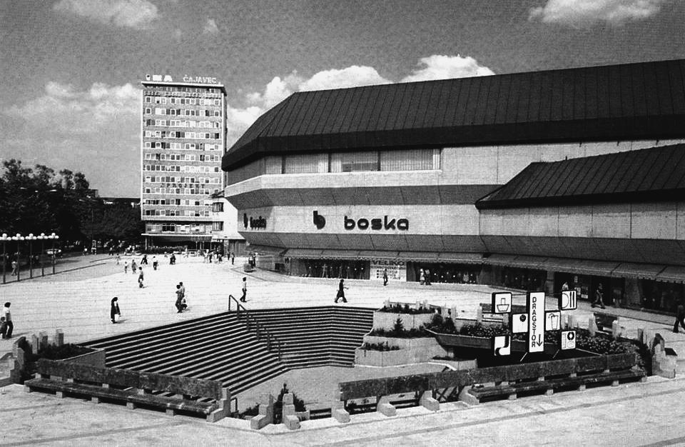
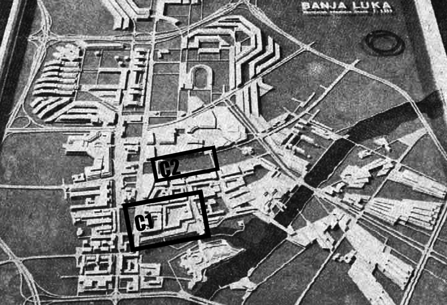
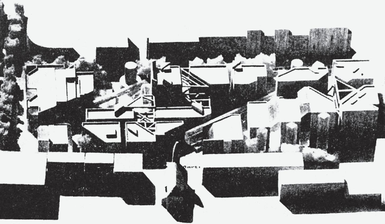
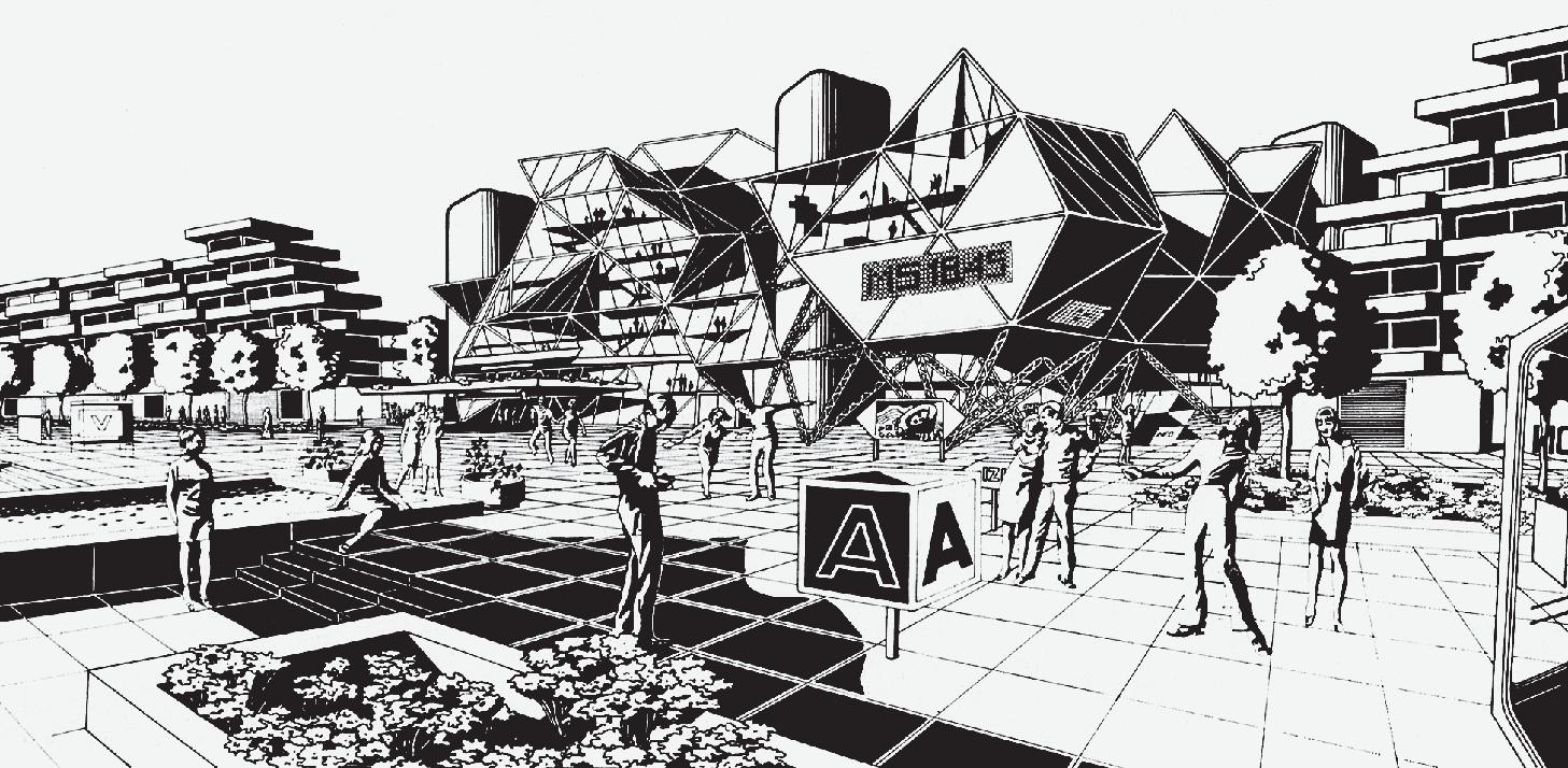
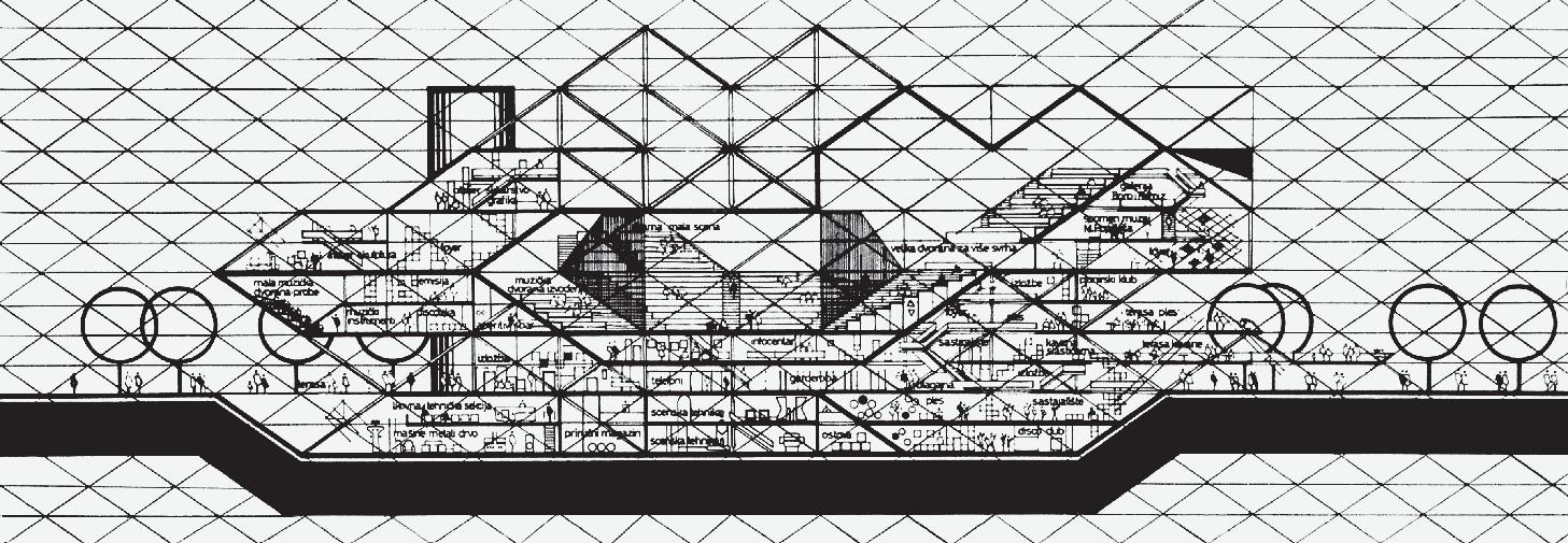
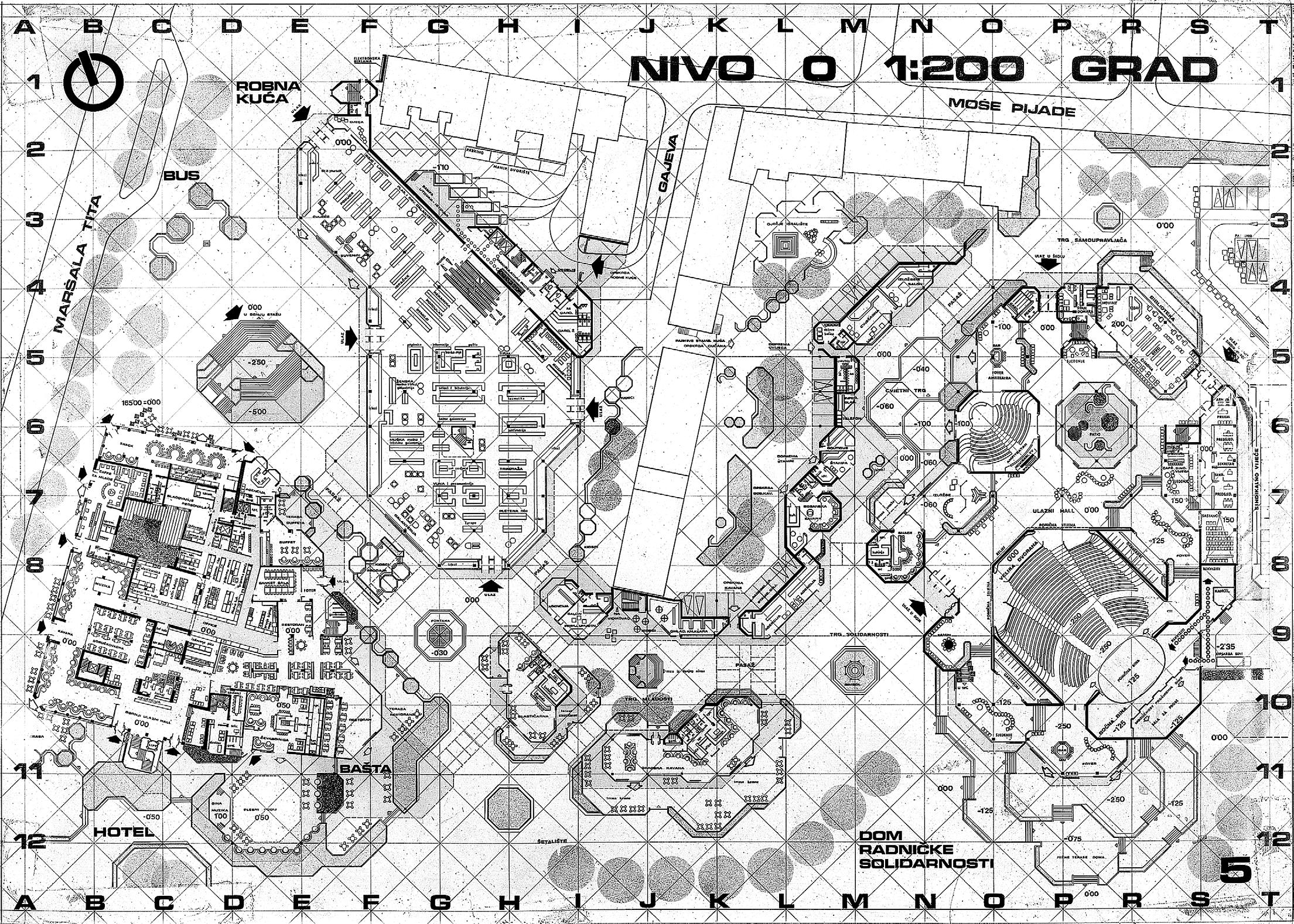
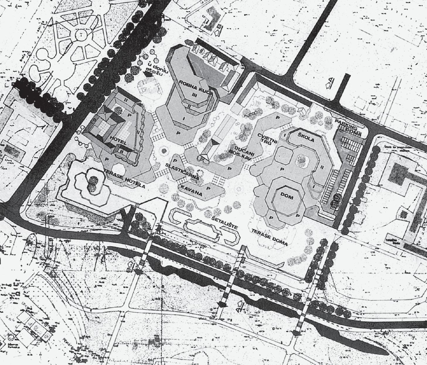
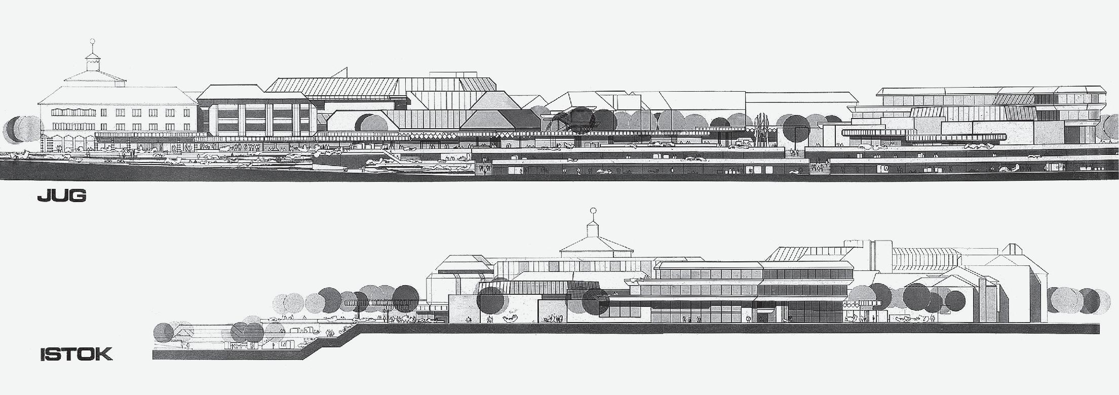
Towards a New Synthesis of Architecture and City Banja Luka’s (Mega)structures from the 1970s https://doi.org/10.31522/p.31.2(66).5 UDC 72+711.4-044.962(497.15 Banja Luka)”197”
A Strategy to Improve Comfort Level and Optimize the Thermal Behaviour of the Building Learning from M’zab Architecture https://doi.org/10.31522/p.31.2(66).6 UDC 628.87+628.89(65)
Preliminary communication
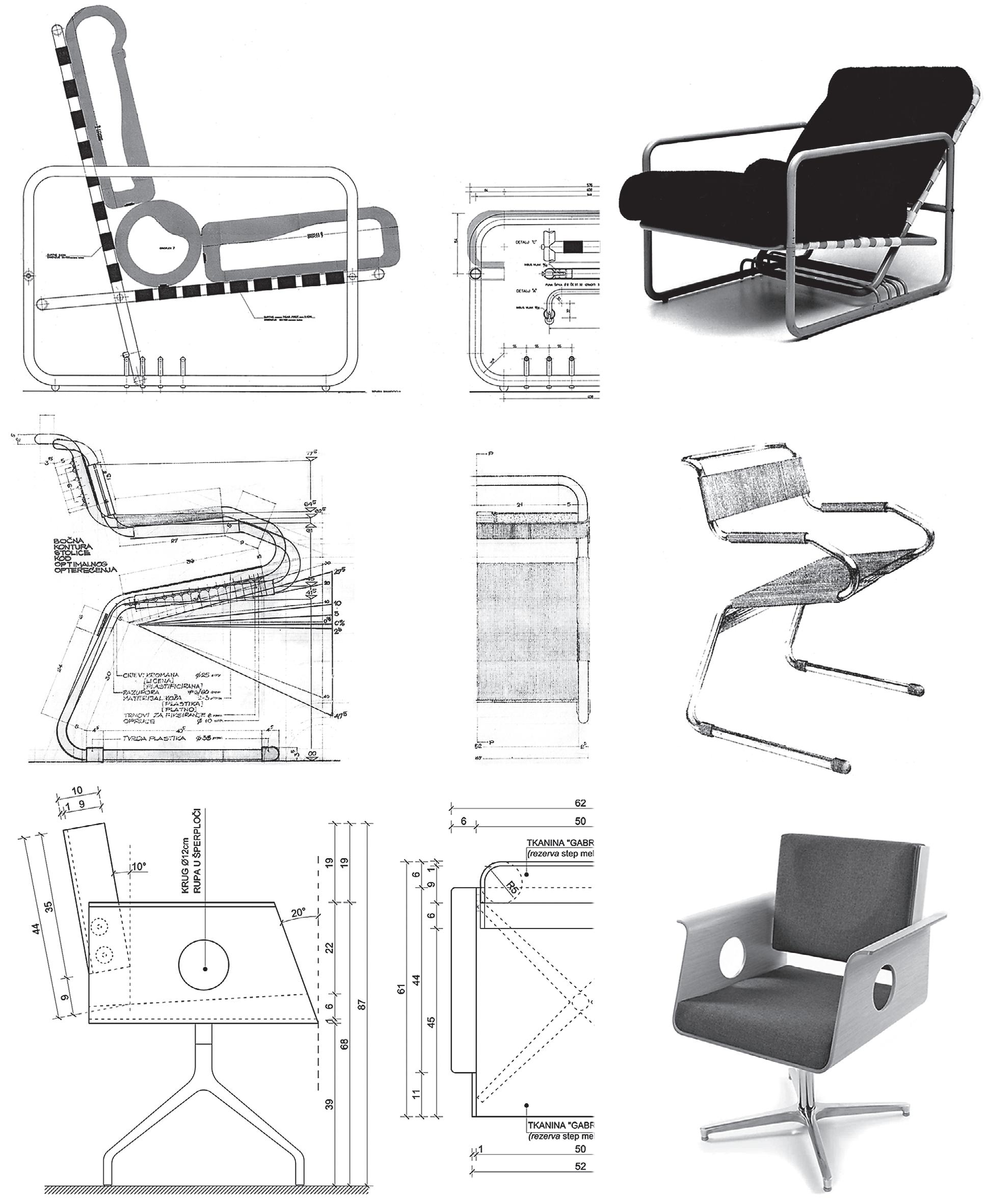
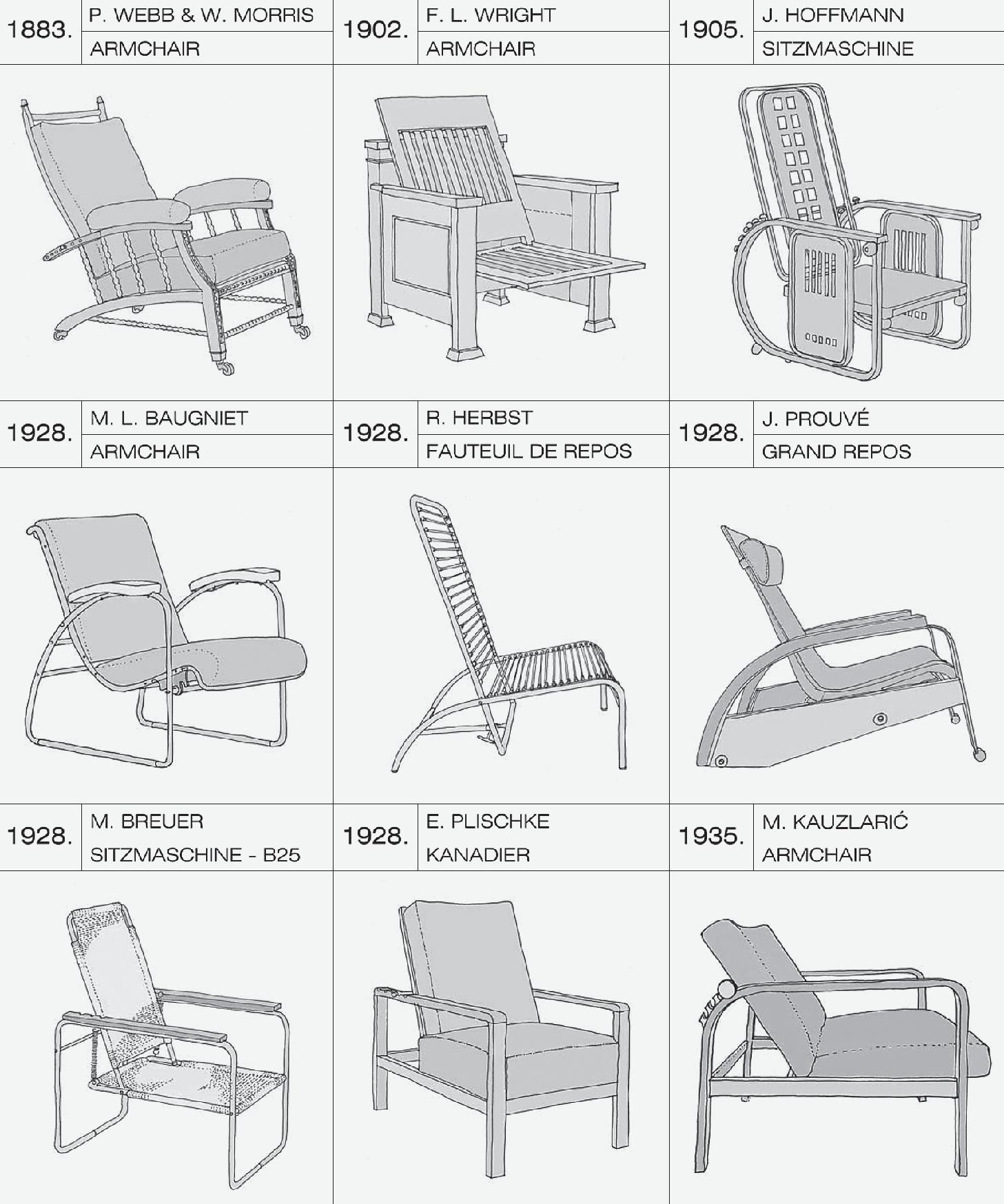
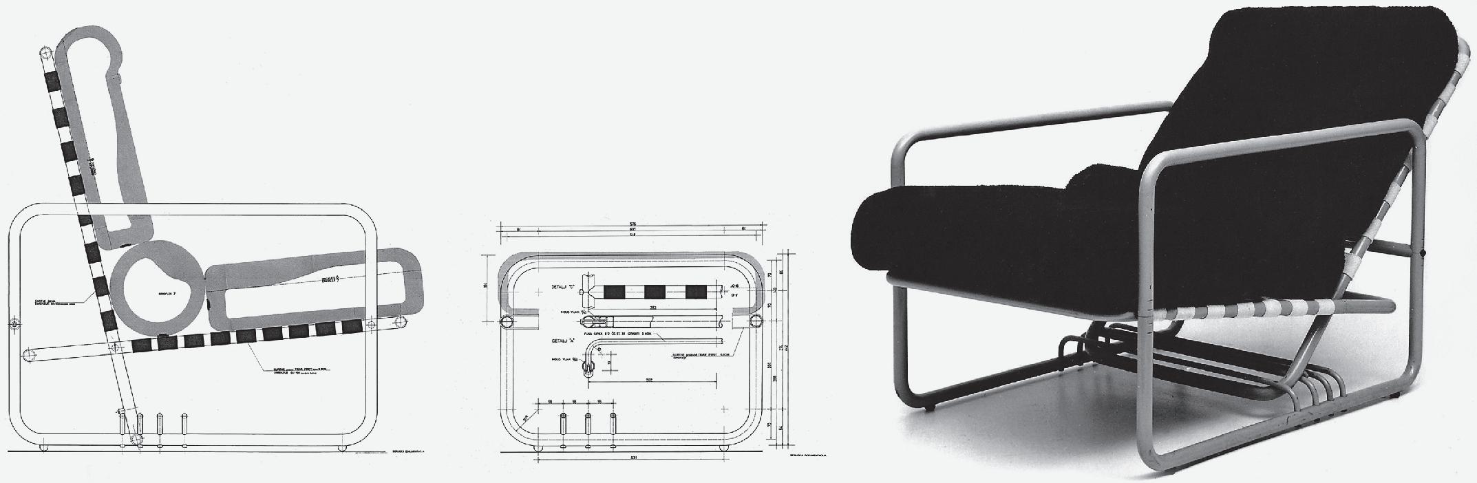
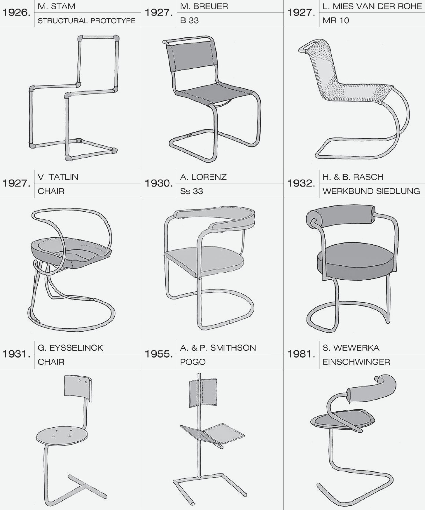
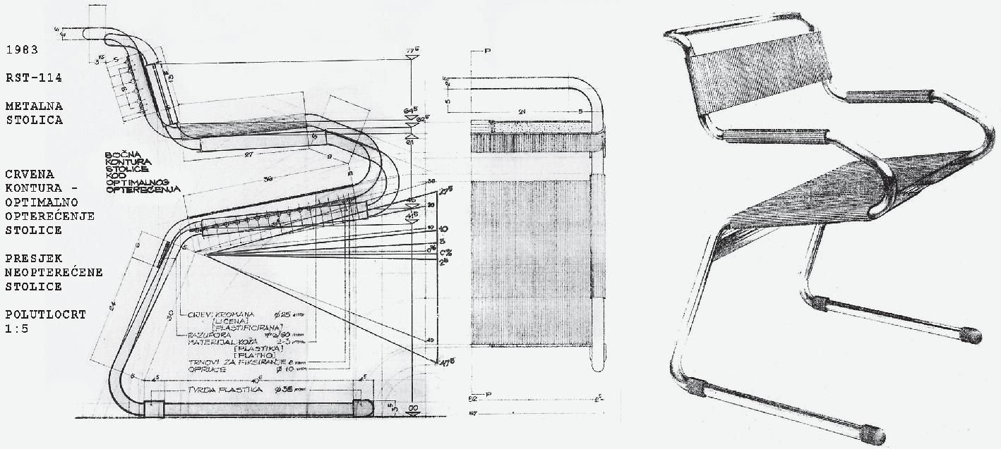
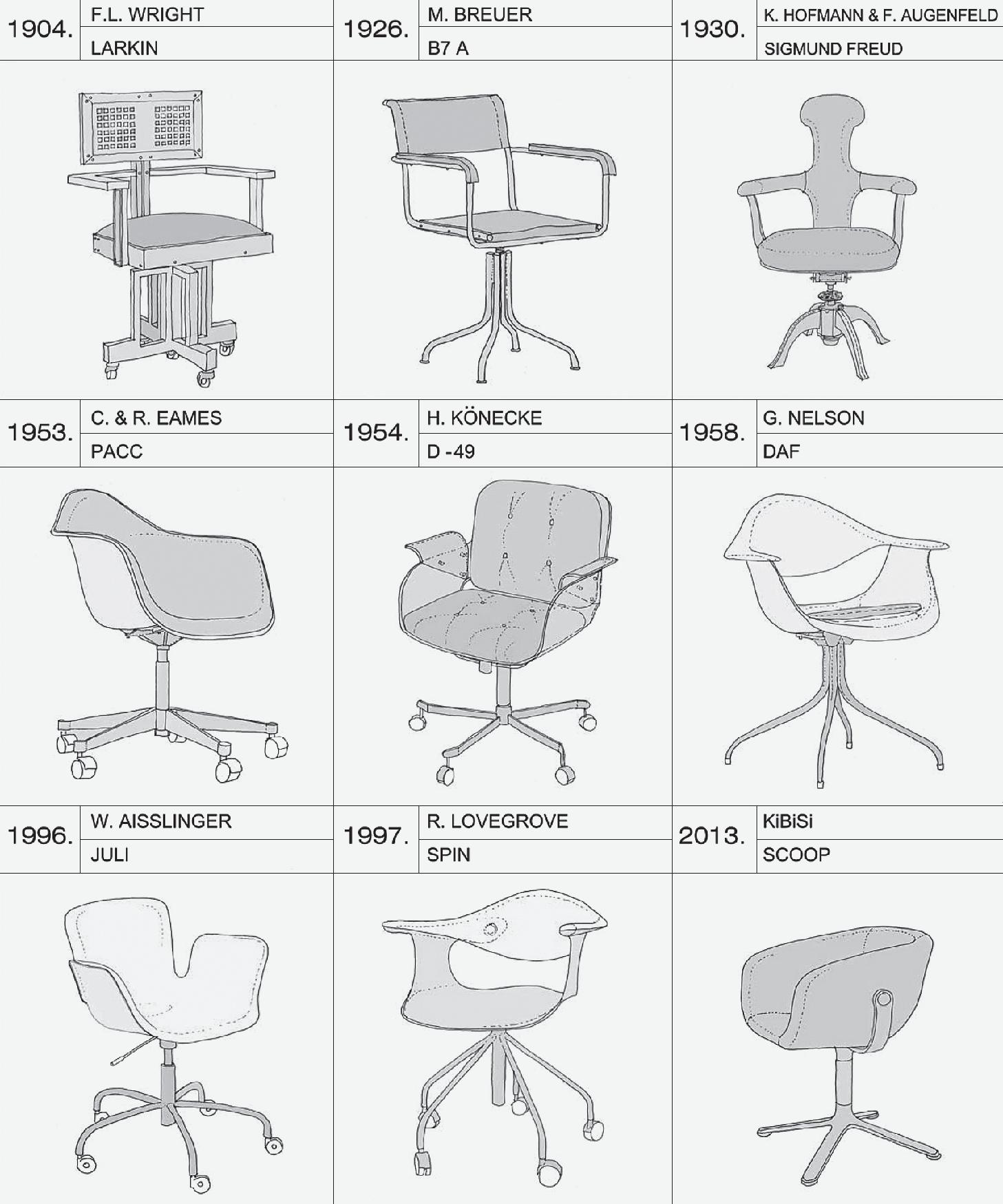
224-235 dInA vulIn IlekovIć BorIs IlekovIć
Chair Architectonics
Architects in the Development of Three Typological and Morphological Chair Designs https://doi.org/10.31522/p.31.2(66).7 UDC 684.43:72
scientific subject reviews
236-247 dAshnor kAdIrI morAnA PAP BojAn BAletIć
248-261 krIstInA Perkov tIhomIr jukIć
262-279 mArk mIŠČevIć mlAden oBAd ŠćItArocI
280-297 dIdem erten BIlgIç kAdIr BIngöl
298-313 İkBAl erBAş
Smart Cities: London, Paris, Barcelona, Milan Definitions and Strategies https://doi.org/10.31522/p.31.2(66).8 UDC 711.4:004(410.111+443.611+460.235.2+450.251)
Historical Development of Military Sites and Their Impact on Urban and Rural Land Use in the European Context Exploring the Social Context and Spatial Footprint https://doi.org/10.31522/p.31.2(66).9 UDC 711.4:355.671(4)
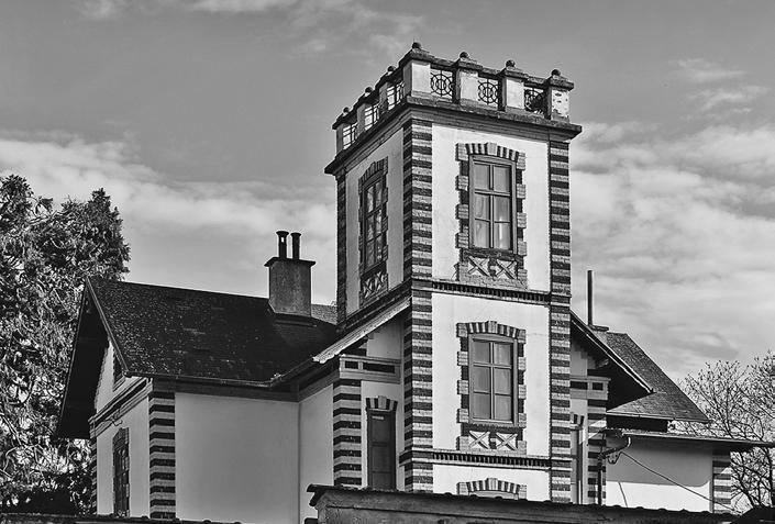
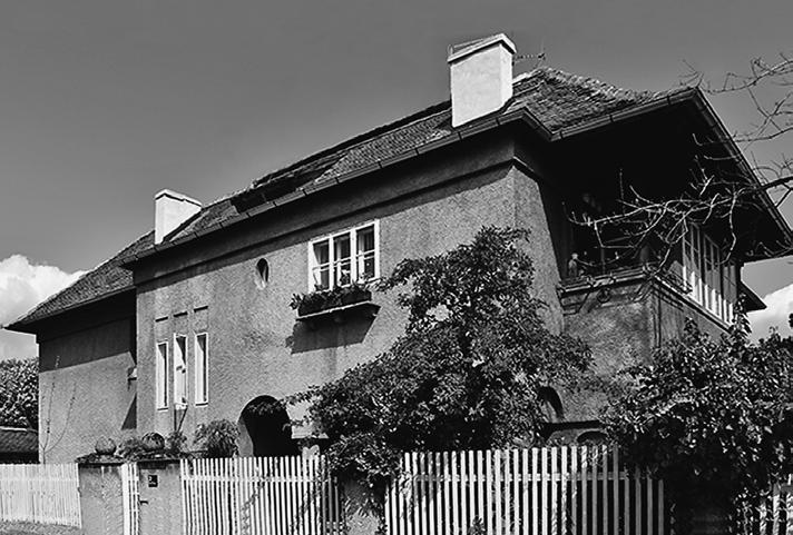
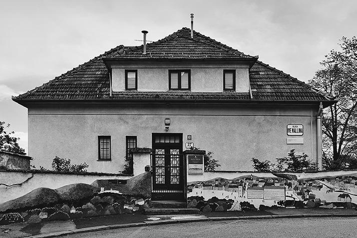
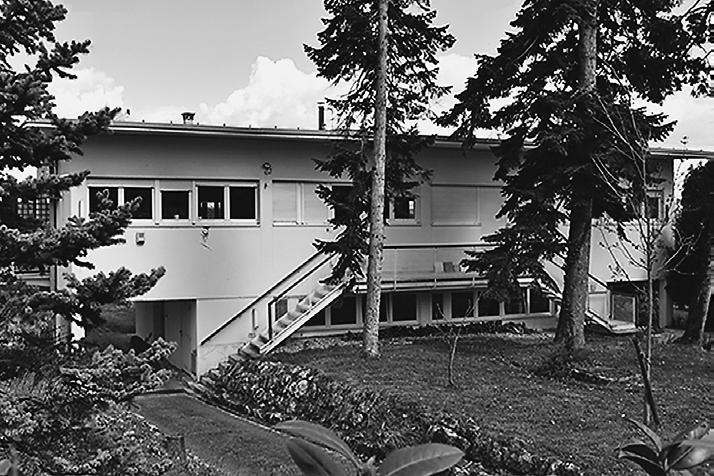
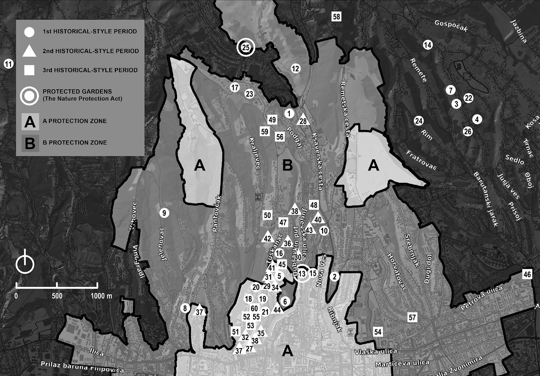
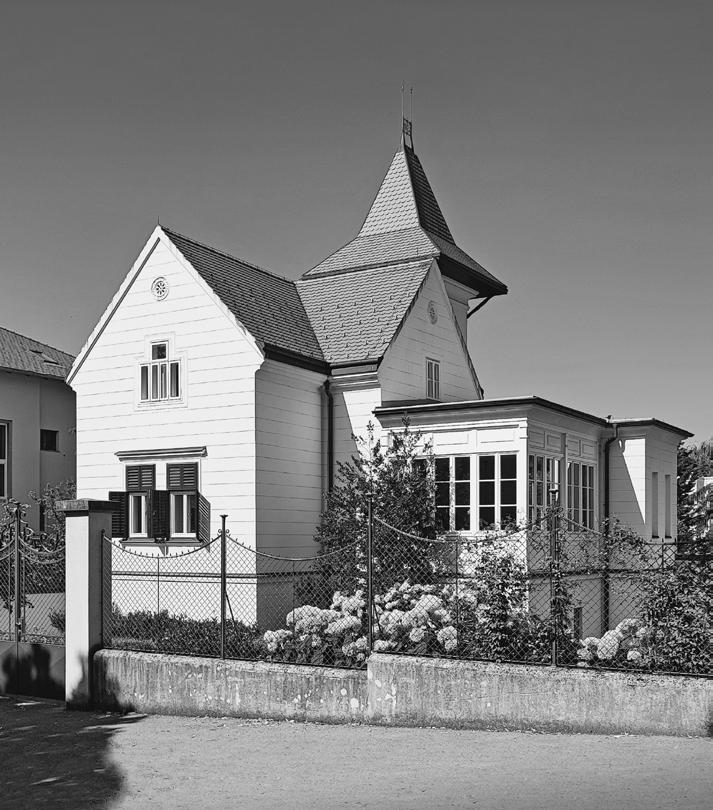
An Overview of Listed Summer Residences and Villas in Zagreb https://doi.org/10.31522/p.31.2(66).10 UDC 728.84(497.521.2)
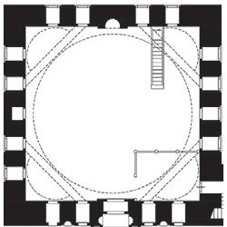
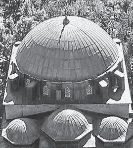
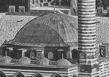
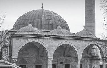
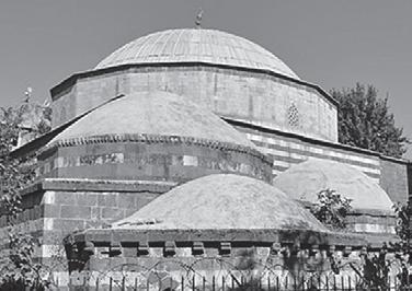
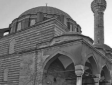
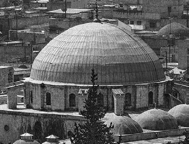
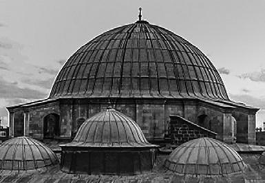
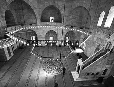
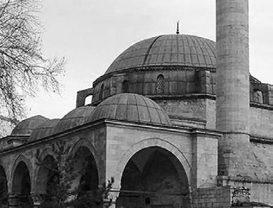
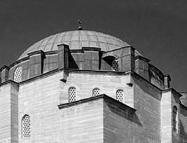
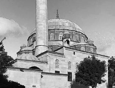
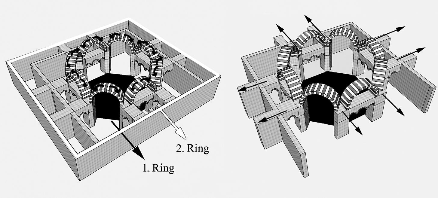
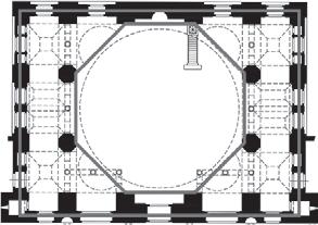
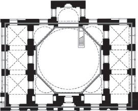
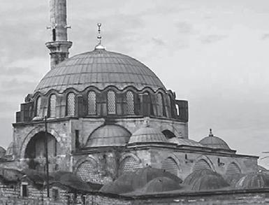
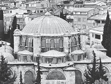
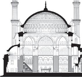
Sinan the Architect’s Process of Creating Spatial Typology: Octagonal Based Central Domes https://doi.org/10.31522/p.31.2(66).11 UDC 692.44 023.465 Sinan
The Influence of Construction Site Internships in Architecture Education
A Study on Kolb’s Experiential Learning Theory
https://doi.org/10.31522/p.31.2(66).12 UDC 378:72
317 mojcA smode cvItAnovIć Dan Doktorata / PhD Day / 2023
University of Zagreb Faculty of Architecture
Doctoral Programme in Architecture and Urban Planning
November 16, 2023
318 tAmArA zAnInovIć
319 IvAnA krmPotIć romIć
Doctoral Dissertations
320-321 Doctoral Dissertations [Summaries]
Instructions for authors
The Urban Rehabilitation of Post-Disaster Scapes
Nerma Omićević Bojana Bojanić Obad Šćitaroci
Future Public Spaces
Urban Design in Times of Crisis
Alan Braun, Doroti Brajnov Botić
The Editorial Board provides at least two independent reviews by prominent Croatian or foreign scholars for all the scientific contributions published in the journal PROSTOR.
Scientific Papers
Domžale
Grosuplje
Kamnik Litija
Slovenska Bistrica
Slovenske Konjice
Škofja Loka
Trbovlje
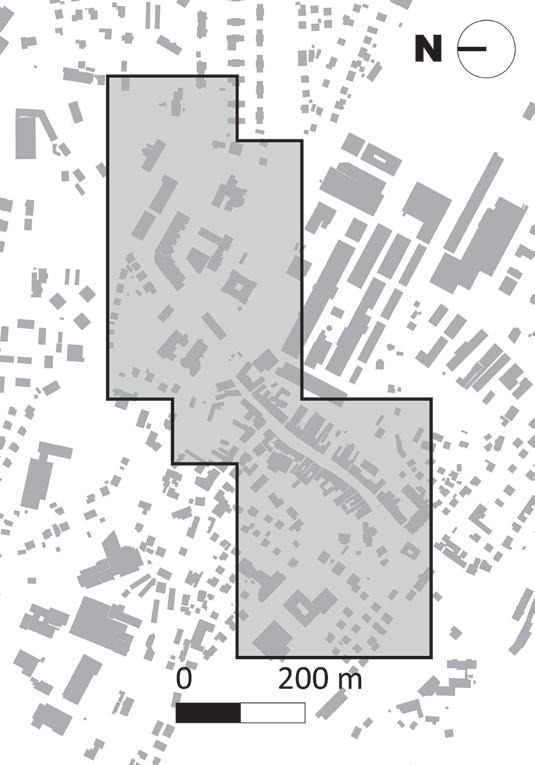
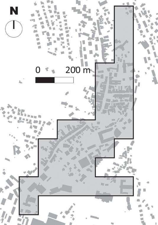
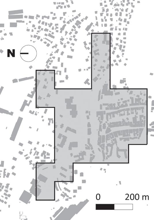
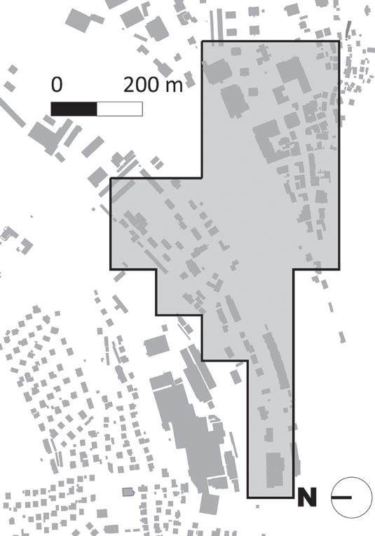
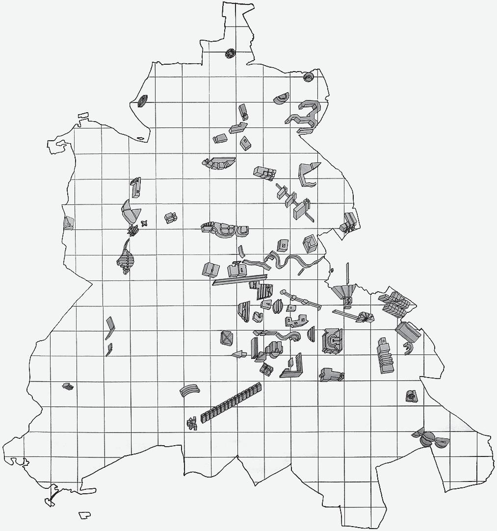
Fig. 1 Centres of eight selected towns
Mateja Volgemut1, Alenka Fikfak2, Alma Zavodnik Lamovšek3
1 University of Ljubljana, Faculty of architecture, Zoisova 12, 1000 Ljubljana orcid.org/0009-0009-4212-7038
2 University of Ljubljana, Faculty of architecture, Zoisova 12, 1000 Ljubljana orcid.org/0000-0003-2064-0016
3 University of Ljubljana, Faculty of civil and geodetic engineering, Jamova cesta 2, 1000 Ljubljana orcid.org/0000-0001-6033-3358
The Impact of Public Open Space on the Image of Small Town Centres in Slovenia
image of the city public open space (POS)
Slovenia small towns town centre
Despite all the principles of sustainable urban design, more and more spaces in small town centres are getting dedicated to traffic. Public open spaces (POS) in these towns are mainly reserved for car traffic, and social activities have been in decline. All at the expense of transportation space and built-up areas. As a result, there are fewer and fewer POS, which provide well-being and comfort to people, are accessible to all and are also attractively designed, allowing the development of a wide range of activities, and contributing to a town’s good image. Therefore, the aim of this paper is to determine the state of provision of POS in the centres of selected small towns in Slovenia and to assess the image of these town centres. Using
various methods and instruments, we tested the hypothesis of whether there is a relationship between POS and the image of town centres. We used a cartographic method and a questionnaire survey, as well as statistical methods, in order to confirm the hypothesis. The study has revealed that groups of morphologically similar small towns are statistically different from each other in terms of observed relationships between POS and the image of the town centre. Therefore, a morphological analysis approach is very important in terms of evaluating the relationship between POS and the image of town centres. In conclusion, recommendations are given for the design of POS in small town centres.
IntroductIon
Thequality of life can be improved by a high-quality built environment, in which the preservation and enhancement of open spaces and public green spaces play an important role (Treaty of Lisbon, 2007; Territorial Agenda 2030, 2020). Given the importance not only of access to services, but also to public open spaces (hereinafter: POS) (ESDP, 1999; CEMAT, 2000; EU Charter, 2000), the New Urban Agenda (2017) places responsibility for the planning, provision and maintenance of such spaces on (local) authorities. Moreover, the European Union aims to achieve a sustainable form of transport by 2050, which can only be achieved through deliberative planning (The New Charter of Athens, 2003) and the improvement and creation of POS that connect the urban fabric.
When it comes to literature, the definition of POS is unclear. Aspects considered involve control, ownership, use, activity, law, and sociology (Carmona et al., 2008), as well as physical manifestation (Jackson, 1984; Scruton, 1984; Carr, 1992; Brown, 2006; Tibbalds, 1992; Zukin, 1995; Kohn, 2004; Carmona et al., 2002) and types of POS (Carmona, 2010). American author Jackson (1984) defined POS as spaces that are accessible to all people, but he was also the first to point out that today these spaces include parking lots, landfills, and highways, so it is obvious that POS are understood as spaces for different types of use. The POS role that has been in-
creasingly emphasised is sociological (Lofland, 1998; Zukin, 1995; Gehl, 1996; Gehl and Gemzø´e, 2000; Staeheli and Mitchell, 2008), meaning that space is not necessarily publicly owned, but is publicly accessible to all on equal terms. It offers a platform for the creation of strong socio-interpersonal ties (Kos, 2008), its physical appearance contributes to the town’s image (Jackson, 1984; Tibbalds, 1992) and facilitates different types of activities (Gehl, 1996), maintained by public institutions (Jackson, 1984). It should also have other universal positive qualities (Carmona et al., 2008) such as order, accessibility, comfort, openness to all people, vitality, functionality, safety, robustness, integrity, and attractiveness. The latter contributes to the POS physical manifestation and the associated image of the city or town, which is one of the concepts of urban design (Carmona et al., 2008). Nasar (1998) explains that the environmental aspect is based on the physical form and is not an abstract aesthetic phenomenon. He also believes that the image of a city depends on the evaluations of the people who use and experience the city regularly, as well as its relationship with the surrounding landscape (Sopina et al., 2019). Nasar continued to rely on the concepts of likability, identity and structure, aiming to improve the image of the built environment, which he similarly to Lynch (1960), also studied in an inductive way. The image of the small town is a subjective term1, because in general it can be derived only from individual assessments of town users and it also comes from the physical appearance of the POS.
A review of recent literature in the field of city image shows that for researching city and town image both qualitative and quantitative research methods (questionnaires, workshops, interviews, case studies, data analyses, office work, etc.) have been used. However, most of the studies conducted between 2001 and 2014 investigating the interaction
1 In this research, it is expressed as an average score of individual assessments of the image of the city centre, resulting from a survey questionnaire.
2 Services of general interest (SGI) are services that are not market-based and include essential public services to which citizens have equal rights and access (SeGI, 2013). In the study, only services that are provided at the local (primary) level are considered: education (kindergarten, elementary school and music school); local court; healthcare (health centre, pharmacy); public administration at the local level (municipal administration, police station); social services (retirement home, employment office, social work centre); cultural services (cultural centre or city cinema, library) and post office (SeGI, 2013; Nared et al., 2016).
3 The functional criterion takes into account the presence of SGI in small towns and was adopted from Nared et al. (2016).
4 Coastal towns should be considered separately, especially given the public interest in the coastal zone (Čok et al., 2018 and 2021).
between different city characteristics and city image (Gilboa et al., 2015) have three shortcomings: 1. they are often based on only one city, which precludes comparisons; 2. there is a lack of statistical validation of results; 3. they refer to a homogeneous group of city users, which prevents the possibility of generalising the results. The same applies to Slovenia, where most studies refer to a single case or are not conducted in a large number of cities that would serve as a starting point for achieving spatial development goals. One of the problems that Robertson (1999) mentions about small town urban centres is their poor image. Among the necessary features of urban centres and ways to revitalize them are the presence of POS and a strong interplay of public and other services (Robertson, 2001), which is also true for urban centres in Slovenia (Volgemut et al., 2021).
From the most important spatial planning acts to spatial planning manuals issued by the ministry responsible for spatial planning, spatial planning laws in Slovenia strategically guide both the image of settlements and the breakdown of built structures in accordance with POS. Accordingly, a sufficient proportion of POS is ensured in settlement planning by taking into account the needs for a distinctive image of the settlement (ZUreP-3, 2021) and an appropriate breakdown of the built structures, which derives from urban planning rules (Nikšič et al., 2021) and regulatory elements (Fikfak et al., 2020).
Since 2021, the Urban Settlements and Landscapes Regulation (ZUreP-3, 2021) has been planned for urban centres as well, and POS are among the recommended elements. Given the settlement system in Slovenia, which is mainly based on small towns, we decided to dedicate this paper to researching the image of town centres in small towns and their co-function with POS. We were particularly
5 The typology of cities is adopted from Drozg (1998):
A - towns with complete medieval, classicist and modernist ground plans (the group does not contain small towns);
B - towns with complete medieval and modernist and incomplete classicist ground plans (Postojna);
C - towns with complete medieval and modernist ground plans (Škofja Loka, Krško, Velenje, Idrija, Lendava, Gornja Radgona, Ljutomer, Lenart, Radovljica, Ajdovščina, Slovenske Konjice, Slovenj Gradec, Kamnik, Sevnica, Brežice, Sežana, Črnomelj, Žalec, Slovenska Bistrica, Tolmin, Ilirska Bistrica, Vrhnika);
D - towns with incomplete medieval and complete modernist ground plans (Kočevje);
E - towns with incomplete medieval and modernist ground plans (Litija, Cerknica, Šentjur, Šmarje, Trebnje);
F - towns with complete medieval and incomplete modernist ground plans (Ormož);
G - towns with complete modernist ground plan (Domžale, Trbovlje);
H - towns with incomplete modernist ground plan (Grosuplje).
interested in the interaction between these two aspects. Therefore, the working hypothesis of the research is: the image of city centres in small towns and the offer of POS in city centres are interconnected.
methods And dAtA
In order for the comparison to be representative, several small towns were included in the study (Robertson, 1999; Anholt, 2006). Qualitative and quantitative research methods (Parkerson and Saunders, 2005; Khirfan and Momani, 2013; Kalandides, 2011) involving a heterogeneous group of people and statistical methods were used. This was a continuation of the research that identified the role of POS in urban development (Vertelj Nared and Zavodnik Lamovšek, 2015).
Selection of Small townS
In Slovenia, the framework of polycentric urban development is formed by small and medium-sized towns (Zavodnik Lamovšek et al., 2008). This paper includes only small towns, since in Slovenia there are 82 of them and they are the most numerous of all towns. However, sociologists and urban geographers (Kos, 2008; Rebernik, 2010) argue that due to the impact of motorised and stationary traffic and the increasing mobility of the population, Slovenian small towns have been experiencing the process of withdrawal of urban activities to urban periphery. Combined with the negative effects of traffic congestion (Lavtižar et al., 2023) and the simultaneous increase of work at home (Čok and Furman Oman, 2019), the process of decline of life and activities in town centres is intensifying. The importance of POS from the point of view of the implementation of services of general interest (hereinafter SGI)2 in small town centres has already been presented in a separate paper (Volgemut et al., 2021).
The selection of small towns was based on three criteria: (1) functional, (2) morphological, and (3) formal. Using the functional3 criterion, a broader selection of 33 towns was formed. The town of Piran4 was excluded due to its spatial characteristics (coastal town) and the particular distribution of SGI. Furthermore, we selected the small towns that differed according to the morphological indicator and considered their differences in terms of the number of inhabitants of the settlement and the municipality. We relied on Drozg (1998), who classified Slovenian towns according to the layout type and defined the physical elements of a town by several parameters: art-historical, social, economic and physical, which are reflected in its layout and image. He defined eight (8) groups (A to H)5
Table I Types of POS (individual definition)
Code Natural forms of POS Code Designed forms of POS
A.1. Water bodies (e.g., rivers, streams, seashores, canals)
A.2. Green spaces (e.g., roadside greenbelts, forests, meadows)
B.2. Paved surfaces (e.g., squares, promenades, streets closed to traffic, markets, squares in front of churches)
B.3. Movement areas (e.g., national roads, municipal roads, streets and sidewalks, railroads, underpasses, bus or train stops, gas stations)
B.4. Service areas (e.g., parking lots, service yards, production and industrial areas)
B.5. Unused areas (e.g., renovation areas, abandoned areas, transition areas)
B.6. Residential landscape (landscaped open space for neighbourhood residents)
B.7. POS in connection with SGI buildings
consisting of combinations of three basic layout types: medieval, classicist and modernist. The wider group of selected small towns6 is represented in seven (7) groups, as no town can be selected from group A, since it contains no small towns. In addition, all small towns with or without a defined medieval and modernist layout (groups C and E) and with or without a defined modernist layout (groups G and H) were included in the selection. Using a formal criterion7, we reduced the shortlist to eight (8) small towns (Fig. 1).
typeS of public open Space
The types of POS to be used in the study were identified based on literature review and fieldwork. They were divided into two groups: A) natural and B) designed forms of POS (Table I).
Spatial
analySiS of town centreS and poS
Spatial analysis was performed using a cartographic method for a shortlist of eight small towns. We also conducted the mapping of POS in their town centre areas. By overlaying different geodetic data, mainly the land cadastre, the building cadastre and aerial photographs (GURS, 2016), we were able to determine the areas of different types of POS. The obtained results were verified by checking the actual location in person, based on which we were able to identify the POS in the town centre areas of eight selected small towns.
QueStionnaire Survey
After the spatial analysis, we created a questionnaire that included five different sets of questions, with a total of 14 questions and an additional demographic set with seven questions. The questionnaire was designed using the 1Ka tool (https://www.1ka.si/) and distributed to the residents of all 33 small towns
of the expanded list. The questionnaire was distributed throughout the municipalities, which informed their residents about the process and the purpose of the survey. A link to the online questionnaire was also provided to the local media, which assisted in inviting residents to complete the questionnaire. In total, between 1798 and 7110 respondents completed the questionnaire.8 This paper presents only the results related to the questions (1) about the interaction between the image of town centres and the availability of POS and (2) about small-town users’ attitudes towards town centres.
After an initial analysis of the survey data at the summary and structural levels, descriptive and interference statistical analyses were conducted, including correlation and regression analyses, and a T-test for independent samples.
Statistical representativeness is ensured despite the fact that spatial analysis, a more precise study of POS, was carried out in 8 towns.
Since the key data for the presented research on POS do not exist in spatial information systems and other sources, it was necessary to create them anew, and such a precise spa-
6 Presented in footnote number 5.
7 The formal criterion represents the size of the town in terms of population, but also includes the population of the entire municipality of the selected towns (MNZ, 2018):
5.000 - 7,000 (in town), 14,500 - 16,000 (in the municipality): Litija, Slovenske Konjice; 7,500 - 12,000 (in town), 20,001 - 26,000 (in the municipality): Grosuplje, Slovenska Bistrica, Škofja Loka; 10,000 - 15,000 (in town), 16,001 - 20,000 (in the municipality): Trbovlje; 10,000 - 15,000 (in town), 26,001 - 36,000 (in the municipality): Domžale, Kamnik.
8 The survey forms that were at least partially filled in were considered; only empty surveys were excluded. 72.1% of women and 27.9% of men answered the questionnaire. The majority of respondents are middle-
tial analysis is very demanding and time-consuming. At the same time, it was assumed that it is not necessary to analyse two towns that are identical in terms of morphological type and have a similar number of inhabitants (in the town and in the municipality), as
-aged (41-60 years old, 52%), followed by the age group of 21-40 years (35.8%), then the older (61 years or older, 9.6%), and the younger (under 20 years old, 2.5%). The majority of respondents have a college, high school, or graduate degree (62%), while few have less than a college degree (1.4%). In between are those with a finished high school (25.3%) and a doctorate (11.3%). The respondents are employed in the town where they live (52.9%), not employed (retired, students, etc. 14.3%), or employed in another city or town (32.8%). The majority of respondents live in a house (76.3%), less of them in an apartment building (23.7%). The majority of respondents have lived in the town for more than 20 years (72.4%), followed by those who have lived in the town for up to 20 years (14.2%), up to 10 years (7.4%), and up to 5 years (6%). The survey was conducted between October 5, 2018 and January 5, 2019.
both analyses would show similar results. Thus, data on 33 towns were obtained by means of a survey questionnaire, and in 8 towns by both methods. There was the opportunity to find out whether the results of both methods coincide.
results
phySical occurrence and the uSe of poS in town centreS
Uniform areas in 8 town centres were determined for the purpose of spatial analysis, where POS and SGI are located. Using a cartographic method, we found that the town centres areas in the small towns are of the same size (27 ha), but differ in terms of morphology and shape, which is due to the fact that the selected towns differ in terms of relief, natural features, cultural heritage, etc. (Fig. 2).
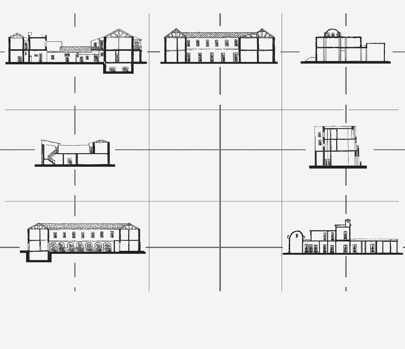
Town centres areas of the eight small shortlisted towns (all images have the same scale, except for the last one, which is twice as small due to the distinct linear shape of the town centre area)
Fig. 2
a) Domžale
e) Slovenska Bistrica
b) Grosuplje
f) Slovenske Konjice
c) Kamnik
g) Škofja Loka
d) Litija
h) Trbovlje
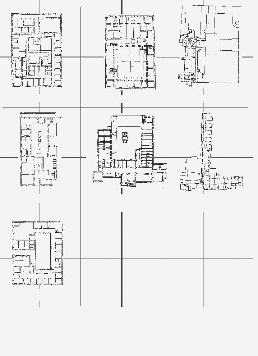
The selected small towns also differ in terms of the size of POS in the town centres (Fig. 3). The largest share of POS in the selected small towns belongs to the type B.3: movement areas (mainly national and/or municipal roads). In addition, a large share are service areas (Fig. 4: B.4.), which confirms the initial findings about the increasing motorization of small towns, which is pushing POS to their periphery. In terms of POS types, Domžale is the city with the highest share of movement and service areas, which have the greatest impact on the very high presence of cars in the town centre.
On the other hand, analysis results have shown that the size of small towns (the number of inhabitants in a settlement and a municipality) and the degree of centrality (Nared et al., 2016) have no influence on the availability of POS in the centres of small towns. The largest share of paved surfaces (Fig. 4: Type B.2.) is in Slovenske Konjice, Kamnik, Škofja Loka and Slovenska Bistrica. All these four small towns have a medieval layout (morphological type C) and were subjected to various measures and interventions in modern times. Nevertheless, they have preserved a good appearance of POS (squares and promenades), which certainly has an influence on the overall good image of the town centre. In other small towns (morphological types E, G and H), where the share of paved surfaces is low, POS in correlation with SGI buildings (Fig. 4: Type B.7) make an important contribution to the overall extent of the POS. The landscaped POS for neighbourhood residents (Fig. 4: Type B.6), often designed as a park with a children’s playground, is also important for pedestrians and bicyclists.
In small towns, water areas (Fig. 4: A.1.) are an important POS when connected to urban green spaces (Type B.1.). However, Litija, which is located on the Sava River, has only a small share of POS along natural areas. The largest share of urban green space is in Slovenska Bistrica, where a large park is part of the town centre (Fig. 4: B.1). Green spaces often exist only in the form of a green belt along the street (Fig. 4: A.2), which has no function and therefore is not used by the residents (Fig. 4: B.5.). In Domžale it is defined as a functionally degraded area.
The results of the questionnaire survey (Table II) show that many users in the selected small towns believe that there is enough POS in the town centre (36%). The smallest share of respondents think that town centres are very well equipped with POS (5%), with a significantly higher share of respondents who are very dissatisfied (11%) or dissatisfied (28%) with the provision of POS. If we exclude the respondents who are undecided (19%), we can conclude that the opinions on the provision of POS in general are quite divided.
The respondents also felt that the provision of POS in the town centres of the small towns differed to a great extent. In Velenje, residents are very satisfied with the presence of POS (66%), while in Trebnje and Trbovlje less than a half of residents are satisfied. The differences between the town centres in the small towns described above were already established by the spatial analysis, which has also been confirmed by the results of the questionnaire survey.
The data from the survey (Table II) and the spatial analysis (Fig. 3) coincide, however the spatial analysis brings a more detailed understanding of POS. The city of Litija, which
Fig. 3 Size of POS by type in the town centres of the eight selected small towns
among the 8 cities has the lowest average rating of POS (Table II), has also a small size of POS (Fig. 3) with positive universal qualities (such as type B.2). This also applies to Grosuplje, Domžale and Trbovlje and vice versa for Slovenske Konjice, Kamnik, Škofja Loka and Slovenska Bistrica. In the chapter Relationship between the provision of POS and the image of town centres, the matching of the results is also statistically confirmed. The town centre of the selected small towns also contains unused areas (Type B.5). Most
respondents are of the opinion that the towns contain abandoned areas, as evidenced by the highest share of residents (37%) who believe there are numerous unused areas in the small town centres. As mentioned above, the town centre of Domžale has a high presence of unused areas (Figure 4: B.5.). This finding is also confirmed by the results of the questionnaire survey (N = 1910), as the presence of undeveloped areas (Fig. 5) is rated the highest (3.88) in Domžale, while the lowest (2.57) is found in Žalec. The average rating
* The POS types are intentionally shown in different
towns, although all types of POS are mostly found
Fig. 4 Illustration of the POS types in selected small towns*
small
in all the selected small towns.
The area in front of the district court in Slovenske Konjice is a square
A parking lot in Grosuplje
Central park in Slovenska Bistrica
In Trbovlje, there is a POS for residents in a residential area
There are two gas stations in the town centre of Litija
Green spaces in relation to roads (Grosuplje)
In the town centre of Domžale there is an abandoned area without function
Large paved areas in Kamnik
In Škofja Loka, the Sora River flows through the town centre
B.7. POS in connection with SGI buildings
B.4. Service areas
B.1. Urban green spaces
B.6. Residential landscape
B.3. Movement areas
A.2. Green spaces
B.5. Unused areas
B.2. Paved surfaces
A.1. Water bodies
for unused areas in all selected small towns is also relatively high (3.36).
image of town centreS in Small townS
As the presence of the unused areas, residents also rated the image of the town centre on a five-point scale, by agreeing with the statement “The image of the town centre is good”. The average rating ranged from 1.94 to 4.02 and the average score of all responses was 2.85 (Fig. 6). The opinion of the users
is also divided regarding the image of the selected small town centres.
While the largest share of all residents agree that the image of the town centre is good (34%), there is a noticeable dispersion of responses; 16% strongly disagree, 24% disagree and 19% are undecided. The share of those who strongly agree that the image of the town centre is good is very low (6%).
relationShip between the proviSion of poS and the image of town centreS
We statistically confirmed the coincidence of the results from the questionnaire survey and the spatial analysis in eight towns. The results obtained were similar. We tested the correlation between the questionnaire data (Table II, average rating, N = 523) and the spatial analysis (Fig. 3) in relation to POS provision (Type B.2 size in m2). The calculated correlation coefficient of 0.82 (p < 0.01) indicates a very high correlation between the two variables. Small towns with a better rated POS provision have more paved surfaces and vice versa. Thus, the regression model proved to be statistically significant [F (8, 6) = 12.67, p = 0.012, R2 = 0.68]. No correlation can be confirmed for other types of POS.
Based on the results of the questionnaire survey, we can conclude that the selected 33 small towns with a better assessed image of the town centre (Fig. 6) also have a better assessment of the provision of POS (Table II) and vice versa. The calculated correlation coefficient of 0.81 (p < 0.05) indicates a high correlation between the two variables. The regression analysis of the influence of POS provision on the image of the town centres showed that the regression model was statistically significant [F (1, 31) = 60.94, p < 0.001]. The POS provision variable can explain 66% of the variable of the image assessment of town centres in small towns. It can be argued that the POS provision has a significant impact on the image assessment of town centres, i.e., a higher POS value leads to a higher image rating of town centres in small towns. We also confirmed the correlation between the two variables on a sample of 8 towns. The size of paved surfaces (Fig. 3, type B.2 size in m2) is related to the image of town centres (Fig. 6, N = 550) in small towns. The calculated correlation coefficient of 0.89 (p < 0.05) indicates a high correlation between the two variables. Small towns with a better rated image of the town centre have larger paved surfaces and, conversely, small towns with a worse rated image of the town centre do not have sufficiently large paved surfaces. The regression model also proved to be statistically significant [F (8, 6) = 22.20, p = 0.003].
Fig. 5 Presence of unused areas
Fig. 6 Users’ assessment of the image of the town centre in the small town (Total: N = 2017)
sample of 33 small towns (r = -0.615, p < 0.01). However, it is more difficult to talk about the influence of the variables on each other, as the variable of the presence of unused areas can explain only 38% of the variable of the image of town centres [F (1, 31) = 18.83, p = 0.0001].
In addition, we tested whether small towns that differ from each other on the basis of the morphological criterion also differ from each other, on average and in a statistically significant way, in terms of the POS provision (Table II) and the image of the town centre (Fig. 6). The analysis was performed for two morphologically similar groups of towns (Footnote 5, C - towns with complete medieval and modernist ground plans and Etowns with incomplete medieval and modernist ground plans), as other groups of towns have a rather small percentage of small towns. It can be claimed that in terms of statistics, the small-town group C (M = 3.12; SD = 0.47) had a significantly higher [t (7) = 3.44; p = 0.01] evaluation of POS provision than the small-town group E (M = 2.46; SD = 0.37). The image of the town centre was also rated significantly [t (11) = 2.59; p = 0.02] higher in the small-town group C (M = 3.06; SD = 0.63) than in the small-town group E (M = 2.53; SD = 0.34).
dIscussIon And conclusIon
Town centres in small towns differ in the size, use, function, and physical appearance of POS, as confirmed by both the spatial analysis and the questionnaire survey. The results of the two methods are consistent with each other, so we can confirm the hypothesis that the image of city centres in small towns and the offer of POS in city centres are interconnected.
The presence of different types of POS in town centres of small towns forms a continuous network of paths and connections between built structures (Tibbalds, 1992). However, it has been noticed that paved surfaces are accessible to all, well maintained, walkable, comfortable, durable, multifunctional, identifiable, safe, and visually appealing, i.e., they have universally positive qualities (Carmona et al., 2008). In other words, this POS type has a qualitative impact on the well-being of small-town users and it does not account only for the suitability for different uses. Summarising Carmona’s (2010) distinction of POS, it can be argued that the movement area (POS type B.3.), which in most cases refers to traffic space, is negative space as it contributes to the disorganization in town centres of small towns and deteriorates their image. We assume that a similar argument could be made for service areas (POS type B.4) and abandoned areas (POS type B.5.) or vice versa for residential landscapes (POS type B.6) and POS in connection with SGI buildings (POS type B.7). However, this was not confirmed statistically. The presented way of analysing the POS of town centres in the selected small towns confirms that a POS with universal positive qualities enhances the image of town centres in small towns. Finally, we add recommendations for the design of different POS types in town centre areas of small towns which are derived from the analysis of towns9 that are well equipped with POS (Table II, Fig. 3) and have a good image rating (Fig. 6). Green spaces (POS type A.2.), such as unbuilt areas in town centres,
9 The planning recommendations are derived from
Fig. 7 Example of the renovation of areas in the town centre of Domžale, which was carried out in 2021 (authors: Mateja and Miha Volgemut)
the spatial analysis of towns: Kamnik, Slovenske Konjice, Škofja Loka and Slovenska Bistrica.
act as meadows and forests where users themselves determine the use and activities. Most importantly, these areas reduce the total built-up area of town centres. Urban green areas cover at least 5% of a town centre area, as defined in this paper. Parks in town centres of small towns are an important spatial element and their location should coincide with the location of SGI. This is because the frequency of their use is low if they are too far from the SGI.
Paved surfaces come in many forms. They may be squares, promenades, streets closed to traffic, markets or squares in front of churches, and other forms of variously paved surfaces of public character. According to the analysis, they cover at least 3% of a town centre area, to ensure that residents have a good relationship with the town centre. In town centres, these areas can be gained by dedicating streets primarily to sustainable traffic - pedestrianisation (Tibbalds, 1992)by narrowing roadways or removing automobile traffic. Some areas simply need to be redesigned, given a new function, or simply improved visually through renovation, urban furniture, and the like. All of this can be accomplished more easily if the land is publicly owned (Speck, 2012). Therefore, the ownership aspect of POS is also important, al-
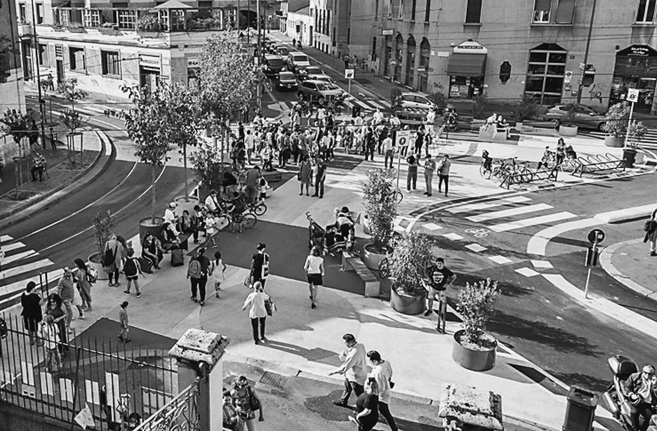
though it is not the focus of this paper. Nevertheless, depending on spatial planning plans and actions at the municipal level, it is possible to acquire and develop publicly owned land, as shown in the example in Fig. 7.
In order for the users of small towns to have a good relationship with the town centre, movement areas must be limited. Analysis has shown that they cover a maximum of 10% of the area of a town centre. These elements (streets, underpasses, bus and train stops) should be designed very carefully according to the human scale (Gehl, 1996), in relation to pedestrian elements, pavement areas and other paved surfaces of POS.
We can conclude that the study of small towns is also important from the point of view of POS. Both the spatial analysis and the answers of the respondents has shown that POS and small town centres are very important from the point of view of their use and the experiential aspect of town centres. The results presented may be helpful not only to spatial planners, but also to decision makers and other individuals who have an impact on the types, extent and image of POS in town centres of small towns.
[Translated by Alma Zavodnik Lamovšek; proofread by Kristina Vrčon]
Bibliography and sources
1. Anholt, S. (2006) ‘The Anholt-GMI City Brands Index: How the World Sees the World’s Cities’. Place Branding and Public Diplomacy, 2(1), pp. 18-31. https://doi.org/10.1057/palgrave. pb.5990042
2. Brown, A. (ed.) (2006) Contested Space: Street Trading, Public Space, and Livelihoods in Developing Cities. 1st ed. Rugby: ITDG Publishing. https://doi.org/10.3362/9781780444703
3. Carmona, M.; Punter, J.V. and Chapman, D. (2002) From Design Policy to Design Quality: The Treatment of Design in Community Strategies, Local Development Frameworks and Action Plans. 1st ed. London: Thomas Telford Publishing.
4. Carmona, M.; de Magalhães, C. and Hammond, L. (2008) Public Space: The Management Dimension. 1st ed. Oxon: Routledge. https://doi.org/10.4324/9780203927229
5. Carmona, M. (2010) ‘Contemporary Public Space, Part Two: Classification’. Journal of Urban Design, 15(2), pp. 157-173. https://doi. org/10.1080/13574801003638111
6. Carr, S.; Francis, M.; Rivlin, L.G. and Stone, A.M. (1992) Public Space. 1st ed. Cambridge: Cambridge University Press.
7. CEMAT (2000) Guiding Principles for Sustainable Spatial Development of the European Continent. Adopted at the 12th Session of the European Conference of Ministers Responsible for Regional Planning on 7-8 September 2000 in Hannover [online]. Hannover: Council of Europe, pp. 25. Available at: /https://rm.coe. int/1680700173 [Accessed: 18.5.2023].
8. Čok, G. and Bolčič, J. (2018) ‘Protokol o celovitem upravljanju obalnih območij v Sredozemlju in sodelovanje javnosti pri prostorskih posegih v slovenskem obalnem pasu’. Annales: anali za istrske in mediteranske študije: Series historia et sociologia, 28(3), pp. 553-568.
9. Čok, G. and Furman Oman, M. (2019) ‘Working at Home as a Spatial Phenomenon - Architectural and Urbanistic Aspects of Regulating Working at Home’. Creativity Game: Theory and Practice of Spatial Planning, 7(2019), pp. 38-45. https://doi.org/10.15292/IU-CG.2019. 07.038-045
10. Čok, G.; Mlakar, A.; Plazar Mlakar, M. and Repe. B. (2021) ‘Analiza načrtovanih prostorskih posegov v obalnem pasu Slovenije z vidika preobrazbe obstoječega stanja’. Annales: anali za istrske in mediteranske študije, Series historia et sociologia, 31(1), pp. 99-116.
11. Drozg, V. (1998) ‘Tlorisi slovenskih mest’. Geografski vestnik: časopis za geografijo in sorodne vede, 70(1998), pp. 75-90.
12. ESDP (1999) European Spatial Development Perspective: Towards Balanced and Sustainable Development of the Territory of the European Union [online]. Luxembourg: Office for Official Publications of the European Communities, 82 pages. Available at: https://op.europa.eu/en/publication-detail/-/publication/ a8abd557-e346-4531-a6ef-e81d3d95027f/lan
13. EU Charter (2000) Charter of Fundamental Rights of the European Union [online]. Brussels: Official Journal of the European Communities, 22 pages. Available at: https://www. europarl.europa.eu/charter/pdf/text_en.pdf [Accessed: 18.5.2023].
14. Fikfak, A.; Nikšič, M.; Černigoj, N.; Grom, J.P. and Konjar, M. (2020) Regulacijski elementi: priročnik. Ljubljana: Ministrstvo za okolje in prostor, Direktorat za prostor, graditev in stanovanja, 109 pages.
15. Gehl, J. (1996) Life between Buildings: Using Public Space. 1st ed. Skive: Arkitektens Forlarg.
16. Gehl, J. and Gemzø´e, L. (2000) New City Spaces. 1st ed. Copenhagen: The Danish Architectural Press.
17. Gilboa, S.; Jaffe, E.D.; Vianelli, D.; Pastore, A. and Herstein, R. (2015) ‘A Summated Rating Scale for Measuring City Image’. Cities, 44, pp. 50-59. https://doi.org/10.1016/j.cities. 2015.01.002
18. GURS (2016) Kataster nepremičnin, Kataster stavb, REN, DOF in drugi prostorski podatki [online]. RS, Ministrstvo za okolje in prostor, Geodetska uprava Republike Slovenije, Available at https://www.e-prostor.gov.si/ in https://pis. eprostor.gov.si/pis. [Accessed: 16.2.2018].
19. Jackson, J.B. (1984) The American Public Space. In: Glazer, N. and Lilla, M. (eds.) The Public Face of Architecture, Civic Culture and Public Spaces. 1st ed. New York: The Free Press, pp. 276-291.
20. Kalandides, A. (2011) ‘City marketing for Bogotá: A Case Study in Integrated Place Branding’. Journal of Place Management and Development, 4(3), pp. 282-291. https://doi.org/10. 1108/17538331111176093
21. Khirfan, L. and Momani, B. (2013) ‘(Re)branding Amman: A ‘Lived’ City’s Values, Image and Identity’. Place Branding and Public Diplomacy, 9(1), pp. 49-65. https://doi.org/10.1057/ pb.2013.1
22. Kohn, M. (2004) Brave New Neighbourhoods: The Privatization of Public Space. 1st ed. New York: Routledge. https://doi.org/10.4324/97 80203495117
23. Kos, D. (2008) ‘Polivalentnost javnih mestnih prostorov’ [online]. Arhitektov bilten: AB: mednarodna revija za teorijo arhitekture, 38(177178), pp. 60-61. Available at: https://www. dlib.si/details/URN:NBN:SI:doc-H9CR2BVS [Accessed: 18.5.2023].
24. Lavtižar, K.; Fikfak, A. and Grom J.P. (2023) ‘Dispersion of Traffic Pollutants in the Built Environment’. Prostor, 31(1/65/), pp. 28-37. https://doi.org/10.31522/p.31.1(65).3
25. Lofland, L.H. (1998) The Public Realm: Exploring the City’s Quintessential Social Territory. 1st ed. New York: Aldine de Gruyter.
26. Lynch, K. (1960) The Image of the City. 1st ed. Cambridge, Massachusetts, London: MIT Press.
27. Ministrstvo za notranje zadeve - MNZ (2018) Agregirani podatki o številu stalno in začasno prijavljenih oseb na identifikacijsko številko navedene občine. RS, Ministrstvo za notranje zadeve, stanje na dan: 14.5.2018.
28. Nared, J.; Bole, D.; Breg Valjavec, M.; Ciglič, R.; Černič Istenič, M.; Goluža, M.; Kozina, J.; Lapuh, L.; Razpotnik Visković, N.; Repolusk, P.; Rus, P. and Tiran, J. (2016) Policentrično omrežje središč in dostopnost prebivalstva do storitev splošnega in splošnega gospodarskega pomena’ [Research report]. Ljubljana: Znanstvenoraziskovalni center Slovenske akademije znanosti in umetnosti.
29. Nasar, J.L. (1998) The Evaluative Image of the City. 1st ed. London: SAGE Publications.
30. Nikšič, M.; Šifkovič Vrbica, S. and Jankovič, L. (2021) Javne odprte grajene površine. Priročnik. Ljubljana: Ministrstvo za okolje in prostor, Direktorat za prostor, graditev in stanovanja.
31. Parkerson, B. and Saunders, J. (2005) ‘City Branding: Can Goods and Services Branding Models Be Used to Brand Cities?’. Place Branding and Public Diplomacy, 1(3), pp. 242-264. https://doi.org/10.1057/palgrave.pb.5990026
32. Rebernik, D. (2010) ‘Teorija in praksa prostorskega načrtovanja: prostorski razvoj mest in širših mestnih območij v Sloveniji’, Dela, 33, pp. 111-127. https://doi.org/10.4312/dela.33. 111-127
33. Robertson, K.A. (1999) ‘Can Small-City Downtowns Remain Viable?’. Journal of the American Planning Association, 65(3), pp. 270-283. https://doi.org/10.1080/01944369908976057
34. Robertson, K.A. (2001) ‘Downtown Development Principles for Small Cities’. In: Burayidi, M.A. (ed.) Downtowns: Revitalizing the Centers of Small Urban Communities. New York: Routledge.
35. Scruton, R. (1984) ‘Public Space and the Classical Vernacular’. In: Glazer, N. and Lilla, M. (eds.) The Public Face of Architecture, Civic Culture and Public Spaces. 1st ed. New York: The Free Press, pp. 13-25.
36. SeGI (2013) Services of General Interests: a European Issue [online]. Luxembourg: ESPON 2013 Programme. Available at: https://www. espon.eu/topics-policy/publications/evidence-briefs/services-general-interest-europeanissue [Accessed: 18.5.2023].
37. Sopina, A. and Bojanić Obad Šćitaroci, B. (2019) ‘Connecting City and Landscape: Urbanism and Landscape Point of View’, Prostor, 27 (2/58/), pp. 270-283. https://doi.org/10.315 22/p.27.2(58).7
38. Speck, J. (2012) Walkable City: How Downtown Can Save America, One Step at a Time. 1st ed. New York: Farrar, Straus and Giroux.
39. Staeheli, L. and Mitchell, D. (2008) The People’s Property?: Power, Politics, and the Public. New York: Routledge.
40. Territorial Agenda 2030 (2020) A Future for All Places [online]. Informal Meeting of Ministers
Responsible for Spatial Planning, Territorial Development and/or Territorial Cohesion, 1 December 2020, Germany. Available at: https:// territorialagenda.eu/wp-content/uploads/ TA2030_jun2021_en.pdf [Accessed: 18.5.2023].
41. Tibbalds, F. (1992) Making People-friendly Towns: Improving the Public Environment in Towns and Cities. 1st ed. Harlow: Longman.
42. The New Charter of Athens (2003) The European Council of Town Planners’ Vision for Cities in the 21st century [online]. European Council of Town Planners. Lisbon: European Council of Town Planners. Available at: https://archive. ectp-ceu.eu/ectp-ceu.eu/images/stories/ download/charter2003.pdf [Accessed: 18.5. 2023].
43. The New Urban Agenda (2017) [online] Adopted at the United Nations Conference on Housing and Sustainable Urban Development (Habitat III) in Quito, Ecuador, on 20 October 2016. Available at: https://habitat3.org/wp-content/uploads/NUA-English.pdf [Accessed: 2.3.2023].
44. Treaty of Lisbon (2007) Treaty of Lisbon Amending the Treaty on European Union and the Treaty Establishing the European Community, signed at Lisbon,13 December 2007 [online]. Official Journal of the European Union C 306, Vol. 50. Available at: https://eur-lex.europa. eu/legal-content/EN/TXT/PDF/?uri=OJ:C: 2007:306:FULL [Accessed: 18.5.2023].
45. Vertelj Nared, P. and Zavodnik Lamovšek, A. (2015) ‘Public Open Space as a Contribution to Urban Development in Small Slovenian Cities’, Urbani izziv, 26 (special issue, suppl.), p.p. 114-129. https://doi.org/10.5379/urbani-izziven-2015-26-supplement-008
46. Volgemut, M.; Fikfak, A. and Zavodnik Lamovšek, A. (2021) ‘Pomen odprtega javnega prostora v središčih majhnih mest z vidika izvajanja storitev splošnega pomena’. Annales: anali za istrske in mediteranske študije: Series historia et sociologia, 31(1), pp. 83-98.
47. Zavodnik Lamovšek, A.; Drobne, S. and Žaucer, T. (2008) ‘Small and Medium-size Towns as the Basis of Polycentric Urban Development = Majhna in srednje velika mesta kot ogrodje policentričnega urbanega razvoja’ [online]. Geodetski vestnik : glasilo Zveze geodetov Slovenije, 52(2), pp. 267-289. Available at: http:// www.geodetski-vestnik.com/52/2/gv52-2_ 290-312.pdf [Accessed: 18.5.2023].
48. ZUreP-3 (2021) ‘Zakon o urejanju prostora - 3’. Uradni list RS, št. 199/21, 18/23.
49. Zukin, S. (1995) The Cultures of Cities. 1st ed. Oxford, Cambridge: Blackwell Publishers.
Illustration sources
Figs. 1-6 Authors, 2023
Fig. 7 Photo: Jurij Bizjak, 2022
Tables I, II Authors, 2023
Authors’ biographies and contributions
Tech. Assist. mAtejA volgemut, PhD. Her current research interests include urban design and open public space.
Prof. AlenkA fIkfAk, Ph.D., MLA. Scientific and professional interests are focused on rural planning, inclusive design, urban heat islands, healthy cities and urban design.
Assist. Prof. AlmA zAvodnIk lAmovŠek, Ph.D. Her current research interests include land use, brownfield regeneration and regional development.
Conceptualization: M.V., A.F. and A.Z.L.; methodology: M.V., A.F. and A.Z.L.; software: M.V.; validation: M.V., A.F. and A.Z.L.; formal analysis: M.V.; investigation: M.V., A.F. and A.Z.L.; resources: M.V., A.F. and A.Z.L.; data curation: M.V.; writingoriginal draft preparation: M.V. and A.Z.L.; writing - review and editing: M.V., A.F. and A.Z.L.; visualization: M.V.; supervision: A.F. and A.Z.L.; project administration: M.V., A.F. and A.Z.L.; funding acquisition: M.V., A.F. and A.Z.L.
All authors have read and agreed to the published version of the manuscript. acknowledgmentS
The authors acknowledge the financial support by the Slovenian Research Agency for co-financing the research program Geoinformation Infrastructure and Sustainable Spatial Development of Slovenia (P2-0227), the research program Sustainable planning for the quality living space (P5-0068), and the research Architectural typologies and architectural landscapes and regions of Slovenia (V5-2111).
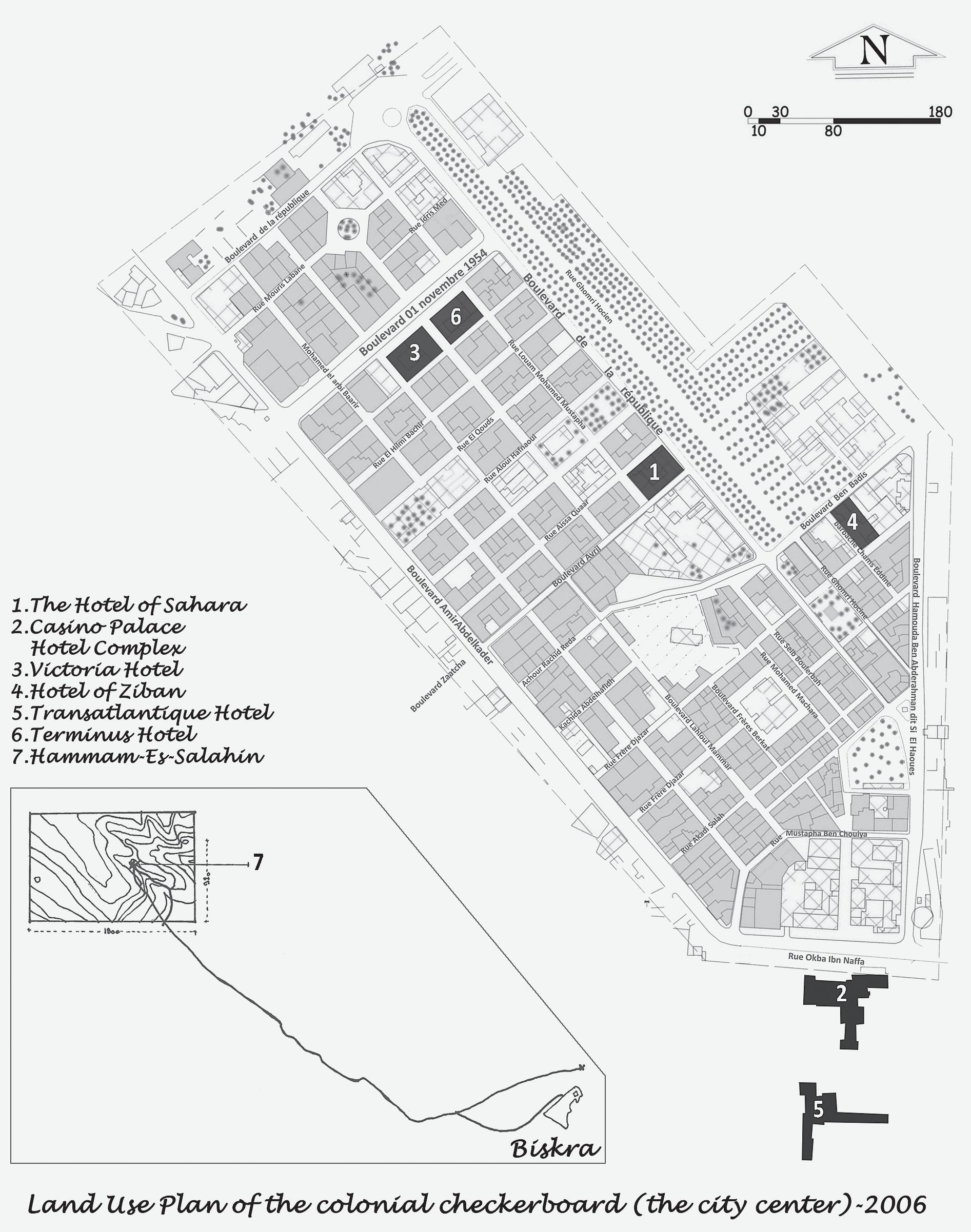
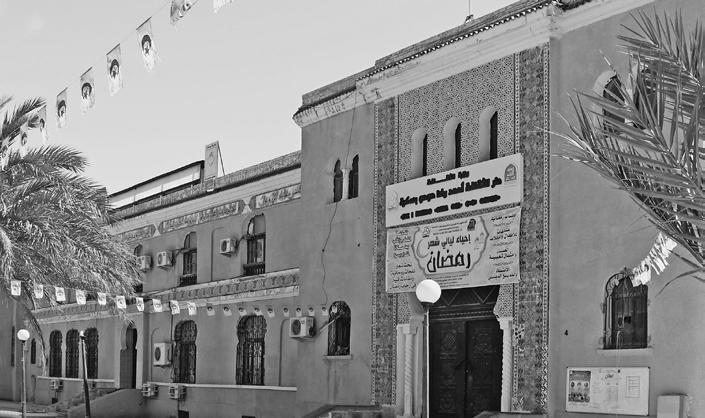
Fig. 1 Location of hotels in Biskra city during the French colonial era
Amdjed Islam Dali, Azeddine Belakehal
Department of Architecture, Université de Biskra, BP 145 RP 07000, Algeria
emdjed@gmail.com
a.belakehal@univ-biskra.dz
Original Scientific Paper
https://doi.org/10.31522/p.31.2(66).2
UDC 640.412:725(653.11)”1883/1962”
Technical Sciences / Architecture and Urban Planning
2.01.04. - History and Theory of Architecture and Preservation of the Built Heritage
Often quoted as the queen of an oasian region, namely the Zibans, Biskra, a southern Algerian city, was a famous winter station renowned for its tourist character during the French colonization (1830-1962). This stimulated the colonizing authorities to build several hospitality buildings, the largest of which were edified using imported constructive techniques, but with local constructive materials and several local spatial organizations and regional decorative motives. In continuation of previous research work carried out by the first author of this article, this study aims to analyse and classify
Biskra’s main hotels to draw up an architectural typology using Philippe Panerai’s method. As a result, four models were identified within the corpus of the study, including seven (7) hotels. Its findings could be considered as strong, helpful support for future research in the field of architectural heritage, regardless of building typology, as well as an appropriate database for the heritage buildings’ practical preservation. Moreover, such research work should inform about other various underrated and misjudged heritage buildings dating from the colonial era in Algeria.
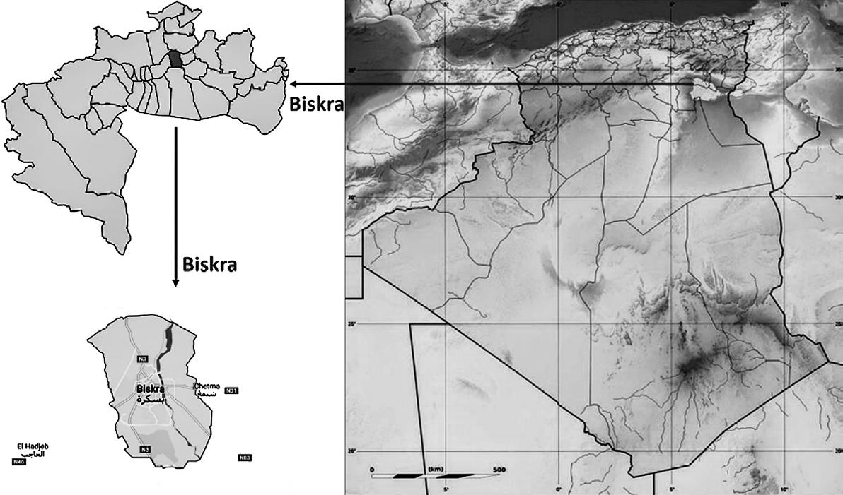
IntroductIon
Biskrais a city located in Algeria, in the north-eastern part of the country (Fig. 2). Archaeological discoveries in Algeria indicate that man lived there over a million and a half years ago (Aumassip, 2001). Furthermore, Phoenician traders settled on the Mediterranean coast in the first millennium BC, calling it Ancient Numidia (Camps, 1979). After that Algeria become a Roman colony, known as Mauretania Caesariensis. Biskra is located on the southern edge of the Roman Numidian Limes, and was the frontier of Roman Numidia (Djouadi, 2018), with many military forts festablished along this defensive line (Baradez, 1949). The Romans laid out the first colo-
nized towns in a regular pattern, adopting the chessboard model (Benevolo, 1988).
In the 5th century AD, after the fall of the Roman Empire, Biskra was ruled by a succession of different civilizations, such as the Byzantines, Arabs, and Ottomans. The city remained a small oasis town during this period, and there is little information about its history (Agli, 1988).
French colonization of Algeria began in 1830 and lasted for a period of 132 years. The country acquired its independence in 1962. Until 1870, Algeria was a territory managed solely by the French army (Grangaud, 2013). Indeed, it was to the military engineering department that all work necessary for the colonization (territorial planning, urbanization, and construction) of mixed and military territories was entrusted (Boufenara, 2017). Consequently, from the Algerian coast to the desert gates, various settlements’ were established, creating a network of towns, colonization centres, and villages (Lieussou, 1850). The urban organization of the colonial city is distinctive (Chaouche, 2013).
Nowadays, colonial urban and architectural heritages still constitute a main component of the urban landscapes and architectural features inside both large and small Algerian cities. This made it evident that post-industrial Algeria was built under French colonial occupation (Dali, 2002). It must be said that built colonial heritage is defined as architectural and urban products that emerged in Algeria during the 19th and 20th centuries, more precisely during the colonization period dating from 05 July 1830 to 05 July 1962 (Picard, 1994). In terms of architecture and urban planning, Algeria was a land of exploitation for the French. Two major styles could be identified, namely: i) the Conqueror’s style, and ii) the Protector’s style (Béguin, 1983).
The Conqueror’s style encompassed three main architectural tendencies as follows: i) neoclassicism, ii) post-revolution, and iii) eclecticism (Table I). Whilst Neoclassicism was characterized by its recourse to GrecoRoman architectural components (Koch, 1978), the post-revolution architectural style, which emerged after the French Revolution, illustrated a distinct reference to Republican Rome (Salimbeni Bartolini et al., 1978; Senhadji, 2014). On the other hand, Eclecticism involved both a selection and a blending of various styles and different architectural components. Thus, this last neoclassic architectural tendency created a whole that has been considered tasteless or pastiche architecture (Epron, 1992).
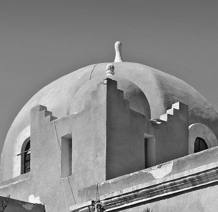
The Protector’s style is known as ‘Arabisance,’ ‘Jonnart’s style’, or ‘neo-Moorish’. The
Fig. 2 Biskra city in Algeria
latter one shall be used in our research. This style occurred during two distinct periods (Table II). Whilst the first era is of concern to official buildings achieved between 1900 and 1930, the neo-Moorish style emerged during the second one, namely post-second World War (1945). In Algeria, this architectural style was applied to some official buildings associating neoclassical components and Islamic architecture (Béguin, 1983). These latter referred to both Algerian Islamic and other Islamic territories’ architectures.
Both styles constitute an integral part of Algerian architectural history during the last two centuries. They reflect the colonial political impulses, successively adopted by the French, which have directly influenced architectural and urban production. In order to impose themselves as colonizers and mark the conquered territory, they imported architecture from other places which categorically rejected the richness of local architecture (Picard, 1994). This style gave way to the Protector’s style. It became a state style after Charles Jonnart issued directives to adopt it as a state style and arabize mainly public buildings (Béguin, 1983).
This architecture changes according to the reference model, and the ‘neo-Moorish’ of the north is different from that of the south since it obviously depends on the region, the available materials, the architect, his influence, his training, and the architectural program (Béguin, 1983).
Building materials were at the heart of the two styles adopted in Algeria. Stone, mudbrick (Adobe), wood, baked brick, tile, and other materials from the Industrial Revolution, as well as concrete, were used. The French also used locally available materials for the foundations of their colonies, as well as others imported from elsewhere and those salvaged locally after the destruction of buildings that hindered their policy of gutting and building new ones. This was done as early as 1830 (Deluz, 1988), together with transforming others to impose their policies and culture (Chenntouf, 1981). These materials were used in the 19th century with techniques imported from elsewhere and the use of a sophisticated local workforce (Chérif, 2017). For the French, Biskra was a field of experimentation in all fields, including construction. Raw earth bricks were the most widely used material in this region (Dali, 2001), reflecting local building know-how.
Most colonial cities were planned and built by French military engineers (Malverti and Picard, 1988). Additionally, these engineers played a significant role in tourism development as well as the conquest and exploration
Table I Characteristics of the Conqueror’s style
Style and Characteristics
Neoclassicism
Regular plan
Alignment of Openings
Uniformity of Bays
Symmetry
Proportions
Post-revolution
Geometry
Axial Symmetry
Ground Floor with Arcades
Openings on the Upper Floor with or without Balconies
Sloping Roof
Eclecticism
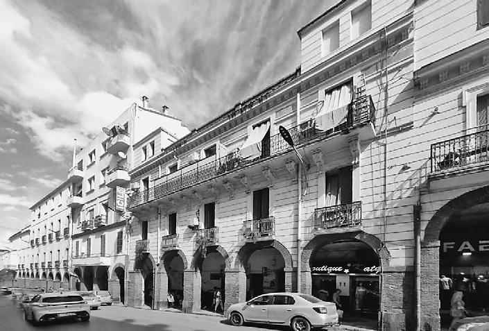
Residential building, Constantine, 2023
Utilisation of Large-Scale Stairs and Arches
Abundant Incorporation of Architectural Elements
Such as Columns, Statues, Garlands, Balustrades, and Pilasters
Flanking Openings
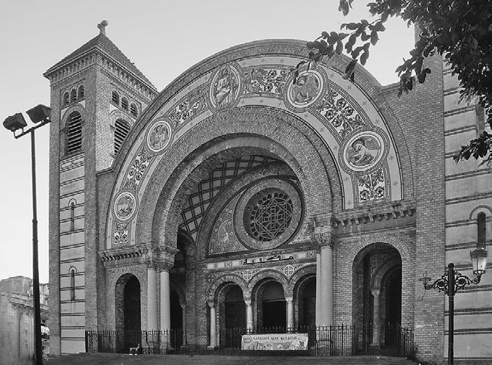
Heart Cathedral of Oran, 2023
Table II Characteristics of the Protector’s style
Style and Characteristics
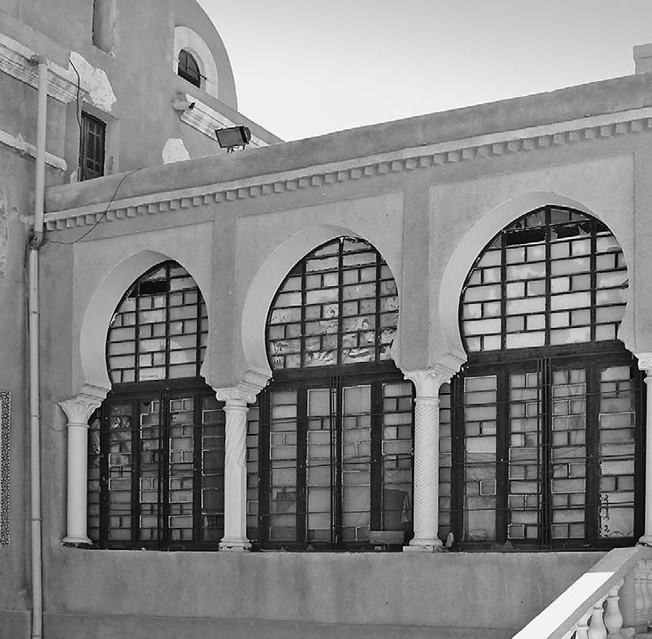
Neo-Moorish 1900-1930
Architectural elements are borrowed from Islamic art, such as the imitation of the minaret and the dome used in some official buildings. The arches used include the horseshoe arch, semicircular arch, polylobed arch, and superimposed arch.
Columns, battlements, cornices, wall coverings, and ironwork.
Geometric and floral decoration, calligraphy, and muqarnas.
Algiers Main Post Office, 2018
Neo-Moorish of 1945
Regularity.
Alignment of openings. Utilization of domes and vaults in various brick forms.
Incorporation of architectural and decorative elements inspired by local architecture. The decorative element is subtly pronounced.
Adrar hospital, 2019
Example
Example
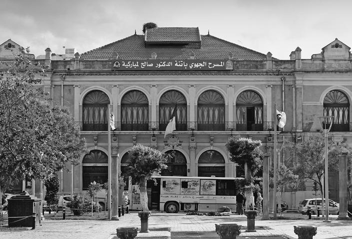
Batna Theater, 2020
Sacred
of the desert (Arnaud, 2009). Considering tourism as a powerful colonization tool, they largely invested in it (Cantier, 2009). Undoubtedly, Biskra is one of the most wellknown Algerian southern cities due to its tourist potential as well as its location on the southern side of the Aurès Mountains and the northern Sahara desert’s border (Roger, 2017). During the colonial period, Biskra gradually transformed into a large oasis with a picturesque tourist attractiveness for European holidaymakers (Pizzaferri, 2011). To attract more Europeans, the colonizer built several excursionist hospitality buildings including hotels. This colonial city, which the French researcher described as the colonial checkerboard (Courtillot, 1985), saw rapid urbanization during the post-independence era. At present, its historic colonial town centre is faced with several challenges, such as the recognition of its local cultural heritage and the related preservation (Zerari et al., 2020). Indeed, this era’s architectural heritage and particularly Biskra’s hospitality buildings remain unknown. The situation has unfortunately grown as a result of the lamentable state of degradation in addition to the demolition of several masterpieces during the post-independence period. Such a situation accentuates the ignorance of this legacy and its various qualities.
Architectural history in Algeria has traditionally focused on the pre-colonial period, such as the Ottoman period (Benyahia et al., 2021), while the 19th and 20th centuries have been largely neglected, with a focus on European architecture instead. Effectively, both colonial urbanism and architecture, dating from this period, have been very recently introduced to the Algerian syllabus for academic training in the field of architecture. The related course presents the history of architecture in Algeria in the 19th and 20th centuries. This research aimed to enrich such knowledge similarly to the ones investigating both housing and public buildings in Biskra city (Belakehal et al., 2015; Zendagui and Belakehal, 2019; Dali and Belakehal, 2019) and other places in Algeria (Mohdeb et al., 2023).
This study focuses on Biskra’s colonial heritage, particularly its architectural character, as revealed through a typological analysis. The used methodology is mostly based on approaches associated with historical, urban, and architectural morphology. Even though its major founding dates back to the end of the 19th century, typological analysis remains widely used by architectural researchers today. It aims to: i) identify the typological characteristics defining Biskra’s colonial-era hotels, ii) state the presence or absence of such characteristics in the case of
other public buildings from the same era and the same area, and iii) assess how much this research methodology could be used for further studies investigating the colonial urban and built heritage.
mAterIAls And methods
Most of the archives of southern Algeria’s towns dating from the colonial period (18321962) could be found in France, either at the ‘Centre Historique des Archives’ located in the Chateau de Vincennes or the ‘Centre d’Archives du 20ème siècle’ (Cité de l’Architecture et du Patrimoine) both in Paris, or L’ANOM (Archives nationales d’outre-mer) in Aix en Provence. However, there are only few graphic documents available there about the public buildings. Thus, the buildings themselves were the main source of information. In addition to the fieldwork, locally found historical data, as well as textual and graphic documents, were used for this research work.
The study adopts typology as an approach allowing the identification as well as the classification of types within a corpus of buildings while considering their diverse specificities. Being evenly applied to a set of numerous elements in the same urban fabric, this method’s objective is to set up a typology illustrating: i) the types’ variations, ii) their general and/or particular formal composition, logic, and order, and iv) the transition process from one type to another. Both Italian and French architecture schools are recognized to be those that have formerly widely applied and developed this approach (Muratori, 1959; Caniggia, 1963; Rossi, 1966; Aymonino, 1973; Castex et al., 1980). Recently, and still on a larger scale, it has been used by several authors for other cities as case studies (Leite and Justo, 2017; Le Fort, 2018; Fraisse and Fadin, 2020).
At the building scale, Petrovska (2010) attempted to enrich heritage knowledge through typology studies that employed a prolific method and allowed the classification of various built structures. Recently, research work has explored and analyzed the formal characteristics of the construction (Santos et al., 2013). Another typological analysis has been applied to a corpus selected from the old center of Seixal by Ollagnier (2016). He undertook a typological inventory aiming to establish a history of Parisian housing over the period from 1770 to 1830. The collected archives used for this research work were mainly graphic, including that era’s architects’ drawings. Moreover, typology is used to analyze different wooden structures of the Church of the Nativity (Macchioni, 2021). Hence, this research is supported by investi-
gations on structural typologies and the outcomes allowed the description of various used wood.
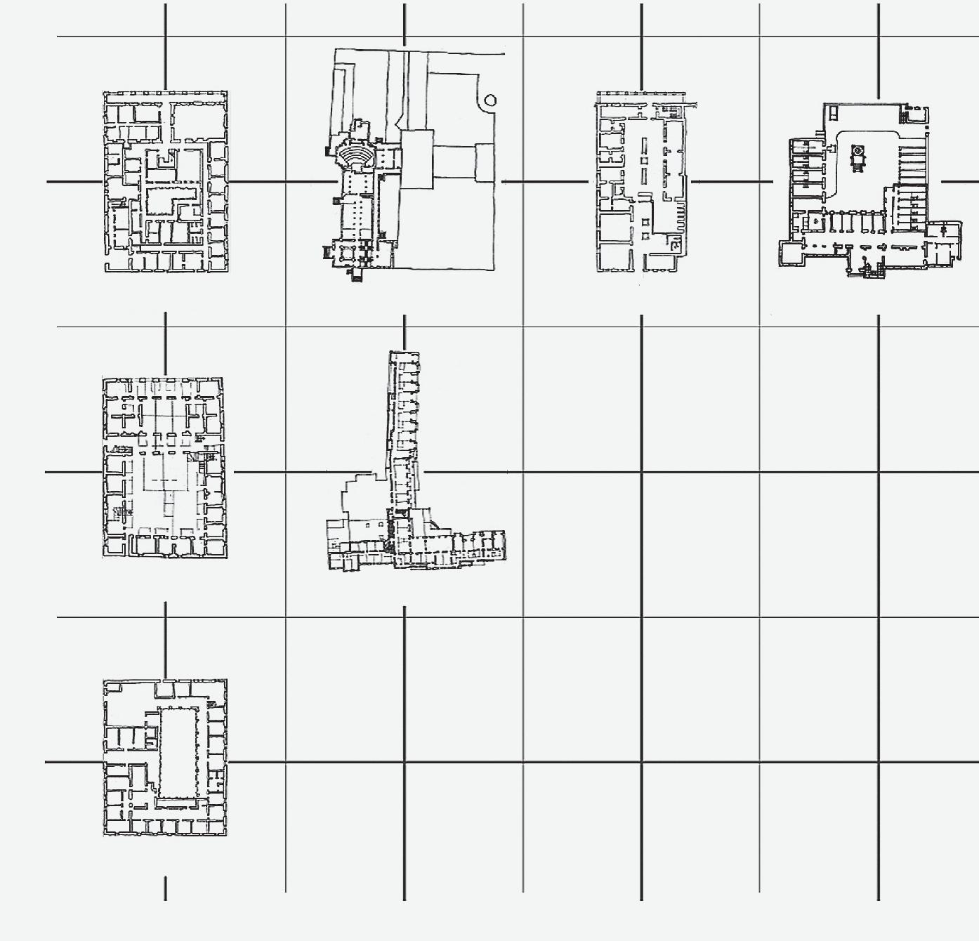
In this work, a typology analysis of Biskra colonial city’s hotels will be mainly respectful to the methodological process of Panerai et al. (1999) due to its relevance for the typological analysis of historic cities. This method is constituted by four phases: i) the definition of the corpus, ii) the preliminary classification, iii) the identification of the types, and iv) the typology constitution.
This study is related to outcomes presented in previous research, dealing with a single object among the considered corpus, which is the hotel of Sahara (Dali and Belakehal, 2019). In addition to the archive’s documents, this study-related collected data is issued from the master’s students’ works undertaken in the Department of Architecture at the University of Biskra, Algeria. Each of these heritage-related master’s dissertations includes a historical study and an architectural survey of a hotel building considered, for the second time, for a design project aiming at its preservation (Zine-El-Abidine, 2014; Bendib, 2014; Rebbouh, 2014; Aidaoui, 2015; Benseghiar, 2015). As a final step, a field survey has been subsequently undertaken in order to check the information found in these masters’ dissertations.
defInItIon of the corPus And PrelImInAry clAssIfIcAtIon
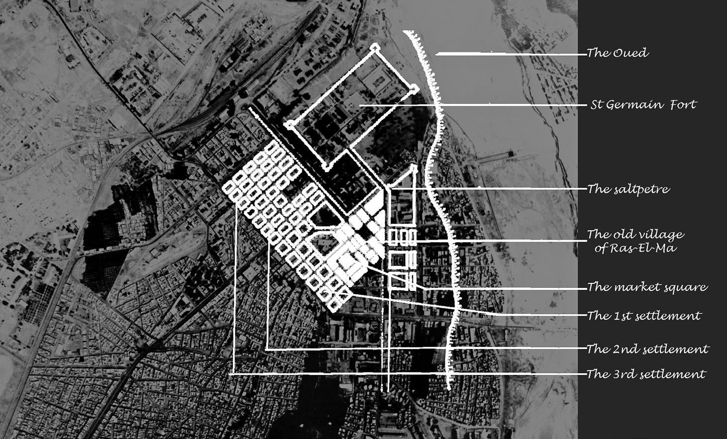
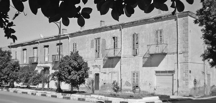
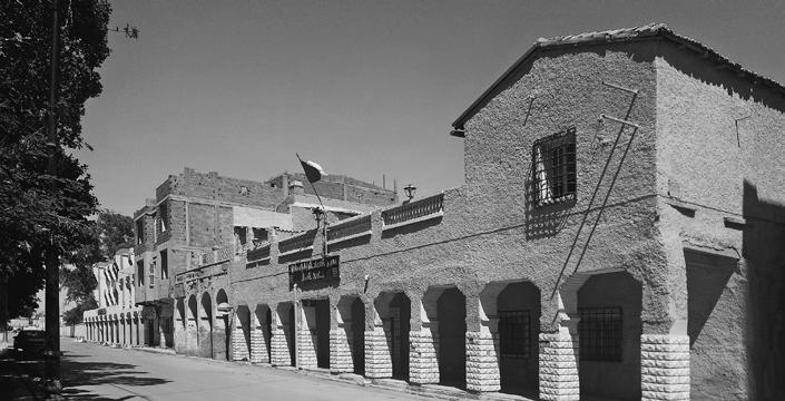
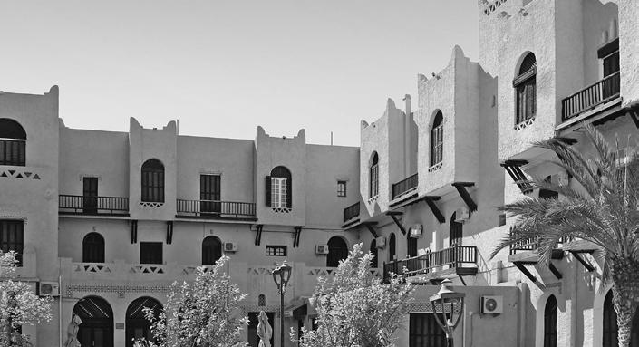
Nowadays, the checkerboard pattern colonial urban fabric of Biskra has become a small district within a growing city. This old typically colonial city was first planned by military engineers and then developed during three main phases (Fig. 3; Agli, 1988; Dali, 2002; Sriti et al., 2002). Its old renowned tourist character was widely illustrated by its rich architecture and hotel facilities (Fraser, 1911).
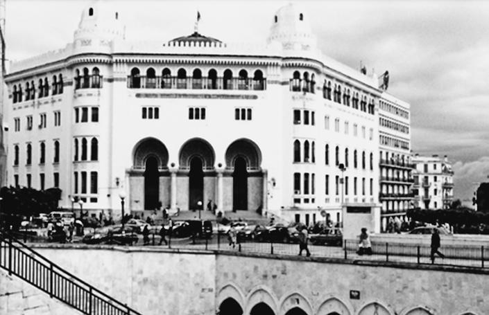
Biskra acquired its universal reputation for the development of hospitality structures (Fig. 1). The archives inform about the existence of a large number of hotels in Biskra well before 1890. For instance, the hotel Sahara (1856-1862) and hotel Oasis (1888), as well as inns like Médan and Bourguignon. And then, several luxury hotels were built, such as the Palace hotel (1893), Royal hotel (1895), and the Victoria hotel. Also, less important structures were realised like the Hotel des Ziban, the Hotel of Orient, the Excelsior Hotel, the Hotel des Familles, the Terminus Hotel (1925), the Hotel de la Gare, the Hotel de L’Europe, the Café-Hôtel-Restaurant and also the charming Robinson Crusoe Inn. Around 1920, the internationally renowned Transatlantic Hostelling Company decided to
in
Moreover, nineteen years later, the
its annex and harboured the staff catering to winter visitors.
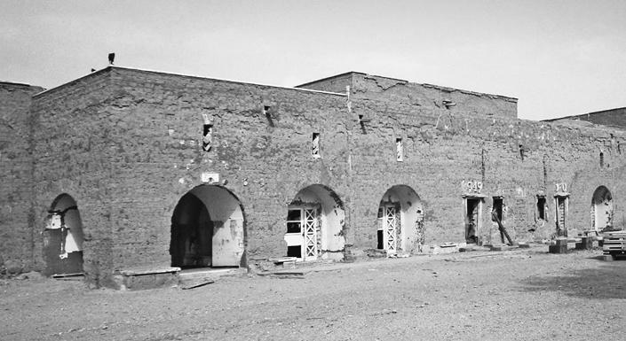
Nowadays, the situation of this colonial-era heritage is very dire, making its preservation nearly impossible. The current state of this historic area and its buildings is disastrous, possibly stemming from the disengagement of its inhabitants and the neglect of local authorities toward this colonial heritage.
Among numerous hospitality structures built in Biskra city, the corpus of hotels considered for this study has been dependently constituted on the related data availability. Due to the lack of valid and authentic historical textual and graphic sources, several buildings were not considered, such as the very famous Royal Hotel and the more modest Oasis Hotel. Finally, seven (07) hotels constitute this study’s corpus as follows (Table III): i) Sahara, ii) Casino Palace, iii) Victoria, iv) Ziban, v) Transatlantique, vi) Terminus, and vii) Hammam (hotel) El-Salahin.
IdentIfIcAtIon of hotel tyPes
For the first classification, six characteristics were adopted: i) Location and land use, ii) the orientation and the shape of the building, iii) the number of floors, iv) spatial-functional organization, v) the architectural style, and vi) the construction materials.
• Location and land use - The hotels’ location and land use are examined: i) with reference to the historical evolution of the colonial city, as well as ii) considering the transition to urban space allowing access to the hotel and exhibiting it as an urban scene
Fig. 3 Evolution of the old, typically colonial city of Biskra
build a hotel
Biskra.
Hotel of Ziban became
Table III Presentation of the study corpus
Hotel / Monograph View
Hotel of Sahara
Built between 1854 and 1861 by the head of the Médan household, the Hotel of Sahara seems to be the oldest in Biskra. It is located on Berthe Street (nowadays Boulevard de la République) facing the main public garden of the colonial city.
Casino Palace hotel Complex
The Casino Palace Hotel also called “Circle of Foreigners” is a tourist complex designed by architect Alexandre Ballu in 1893. It is located south of the colonial town on the street leading to the town of Touggourt.
Victoria hotel
The Victoria Hotel was built at the end of the 19th century by the German Oser Auguste. Far from the original city center, it is located on the formerly called Gambetta Boulevard (nowadays boulevard of 1st November 1954), at the end of the northern district of the new city, a quiet and peaceful area.
Hotel of Ziban
Formerly built as a convent of the sisters of Charity and the White Fathers, this building was designed in 1872 according to architect Domimnon’s drawings. In 1911, its new owner, namely Donin De Rosičre, reconverted Cardinal Lavigerie’s former residence into a hotel. Between 1920 and 1939, the hotel became an annex of the hotel Transatlantique.
Transatlantique hotel
The Transatlantique Hotel is located outside but not far from the checkerboard pattern colonial urban fabric, and next to the Palace hotel as well as on the street leading to Touggourt. It was designed by architect Guiauchin and built by the Rodari Brothers’ Company between 1916 and 1920.
Terminus hotel
Located near the Victoria Hotel, the Terminus Hotel was built in 1925 and managed by Barthélemy Sanino and his wife.
Hammam-Es-Salahin
The Hammam is located 7 km northwest of Biskra city. At the end of the 19th century, the baths became more or less internationally famous, and the commune entrusted the Biskra company with the management of the place. This company built a bathing establishment on the site of the spring and laid out a pleasure park. The new building was designed by architect Albert Ballu.
I
Occupation of a parcel of the block in the colonial checkerboard level
II
Occupation of an entire block located in the colonial checkerboard
VARIANT III
Occupation of a parcel of the block outside the colonial checkerboard
component (Fig. 4). Hence, in the first stage area of the colonial city, the hotel occupied a plot or a block as it is shown by the case of the Ziban hotel.
In a further stage and precisely inside what is namely known by the checkerboard pattern urban fabric, we first notice the occupation of an entire block as observed in the hotel of Sahara, the Victoria hotel, and the Terminus hotel. However, a difference exists between the first hotel and the two others. Whilst the first one includes an urban gallery (with arcades) closely adjacent to the street’s border, it is a wide, urban open-to-sky esplanade that precedes the Victoria and Terminus hotels’ entrances.
Thirdly, outside of the checkerboard pattern urban fabric area and similar to those of the colonial city’s first stage, the hotel occupied a plot within a block. However, the size of the plot is larger when compared to the case of the Ziban hotel. Both Palace hotel and Transatlantic hotel represent this variant but differ in terms of inclusion or exclusion of a wide urban open-to-sky space. Finally, the fourth variant is the occupation of an extra-urban site illustrated by Hammam-Es-Salahin
• Orientation and shape of the buildingFour variants have been identified in terms of the building’s orientation and shape (Fig. 5).
The first variant is that of a building with a parallelepiped shape oriented to the northeast, such as the hotel of Sahara, the Victoria
VARIANT IV
Occupation of an extra-urban site
VARIANT I
Building with a parallelepiped shape oriented to the northeast
Hotel, and the Terminus Hotel. However, these last two cases differ slightly from the first, because their main facades are oriented northwest, unlike the hotel of Sahara’s main façade, which is oriented northeast. This orientation is mainly due to the urban hierarchical importance of the street where the hotel’s main entrance is located.
The second one is related to a building with a parallelepiped shape, oriented northwest, as in the case of the hotel des Ziban. The third variant includes two buildings of elongated shape, one part of which is oriented to the south and the other to the east: The Palace hotel is L-shaped whilst the Transatlantic hotel is T-shaped. This configuration seems to be an aerial characterization illustrating the first letter (T) of the name of a hotels’ chain that was very famous during this era. The last variation is a building with a parallelepiped shape and oriented to the south, that is Hammam-Es-Salahin’s case.
• Number of floors - Although the height of buildings is limited in the Biskra region, due to both climatic and geotechnical constraints (resistance of the natural soil), three construction variants are identified in terms of the number of floors (Fig. 6). The first variant is the building composed of an underground floor; two-floor levels topped by an attic. This is the case with the hotel of Sahara, the Ziban hotel, and the Terminus hotel. The second
VARIANT II
Building with a parallelepiped shape oriented northwest
VARIANT III
Building with elongated shape, one part of which is oriented to the south and the other to the east
Fig. 4 Location and land use
VARIANT IV
Building with a parallelepiped form oriented to the south
Fig. 5 Orientation and shape of the building
PALACE HOTEL
TRANSATLANTIQUE HOTEL
THE HOTEL OF SAHARA
VICTORIA HOTEL
TERMINUS HOTEL
VARIANT
HOTEL OF ZIBAN
VARIANT
VICTORIA HOTEL
THE HOTEL OF SAHARA
TRANSATLANTIQUE HOTEL
PALACE HOTEL HAMMAM-ES-SALAHIN
HOTEL OF ZIBAN
HAMMAM-ES-SALAHIN
variant is that of the building composed of two levels overworked by a roof, such as the Victoria hotel. Finally, a building with two or three levels, covered by a flat roof that may or may not include an underground floor, such as the case of the Palace hotel, the hotel Transatlantique, and Hammam-Es-Salahin.
• Spatial-functional organization - In terms of spatial-functional organization, only two variants are detected: i) a set of interior spaces surrounding a central core (a garden or courtyard) that is illustrated by the major number of case studies (hotel of Sahara, Victoria Hotel, hotel of Ziban, Terminus Hotel and finally Hammam-Es-Salahin), and ii), a set of interior spaces arranged on either side of the distribution corridor or along one side only (The Palace Hotel and the Transatlantic Hotel; Fig. 7).
• Architectural style - In the checkerboard pattern colonial urban fabric, two styles are mainly identified while presenting several variants for each of them (Fig. 8). First, we can identify the buildings designed with respect to the Conqueror’s style, and more precisely the post-revolution variant, such as the hotel of Sahara and the hotel of Ziban. In respect of the same style, but according to the neo-classical variant, the Victoria Hotel and the Terminus Hotel are recognized. For the first variant, we can notice: Geometry, ii) Axial Symmetry, iii) Ground Floor with Arcades
VARIANT I Spaces organization around a central core
VARIANT II Spaces organization along the corridors of distribution
iv) Openings on the Upper Floor with or without Balconies, and v) Sloping Roof.
For the second one, the following components could be detected: i) Regular plans and elevations, ii) Alignment of Openings, iii) Uniformity of Bays, and iv) Symmetry.
Differently, the last variant consists of those buildings respectful of the protector’s style principles such as the Palace Hotel, the Transatlantic Hotel, and Hammam-Es-Salahin. Their main characteristics are: i) Architectural Elements Inspired by Islamic Art, ii) Arches, iii) Columns, and iv) Geometric Decoration.
• Building materials - The buildings of the checkerboard pattern urban fabric are largely constructed with local materials (Fig. 9), in particular the mudbricks (Adobe). This is the main building material in many of our case studies (the hotel of Sahara, the Victoria Hotel, and the Ziban Hotel). Whilst this material was locally extracted, the construction techniques were somewhat developed when compared to traditional local ones. Besides, stones were used in three buildings: the Palace Hotel, the Transatlantic Hotel, and the Terminus Hotel. In addition to traditional local materials, various other materials have been introduced to the region, including Ibeams (IPN), timber beams, tiles, fired bricks, and more. These materials have been employed in foundations, walls, ceilings, and roofs, effectively adapting to both earthen
Fig. 6 Number of floors
Fig. 7 Spatial-functional organization
VARIANT I Building composed of a basement and two levels topped by an attic
THE HOTEL OF SAHARA
HOTEL OF ZIBAN
TERMINUS HOTEL
VARIANT II Building composed of two levels overworked by a roof
VICTORIA HOTEL
VARIANT III Building composed of two or three levels with a flat roof
PALACE HOTEL
THE HOTEL OF SAHARA
HOTEL OF ZIBAN
TERMINUS HOTEL
VICTORIA HOTEL
HAMMAM-ES-SALAHIN
PALACE HOTEL
TRANSATLANTIQUE HOTEL
TRANSATLANTIQUE HOTEL
HAMMAM-ES-SALAHIN
and stone structures. Singularly, the use of cement concrete as a structural building material with a hollow brick masonry filling has been identified for the case of Hammam-EsSalahin.
dIscussIon
This research’s main outcome is the identification of four typological models among a corpus of Biskra’s colonial-era hotels and with respect to its urban expansion stages (Fig. 10). One of these typological models has three variants, the second comprises two whilst, the other two typological models encompass only one variant each.
The first typological model seems to be the most widespread in the colonial city of Biskra including the hotel of Sahara, the Victoria Hotel, and the Terminus Hotel. This typological model is characterized by its occupancy of a standard block’s total area inside the checkerboard pattern urban fabric. A public transition space is provided as a large esplanade or an arcade gallery at the ground floor level on the main facade side. These buildings include an internal open-to-sky space (garden or courtyard; Fig. 12). Because the urban block is geometrically rectangular and oriented towards the northeast, the hotel is respectful of these constraints and has a parallelepiped shape that follows the same orientation. In
8 Architectural style
9 Building materials
Fig.
Fig.
THE HOTEL OF SAHARA
THE HOTEL OF SAHARA
VICTORIA HOTEL
VICTORIA HOTEL
HOTEL OF ZIBAN
HOTEL OF ZIBAN
TERMINUS HOTEL
TERMINUS HOTEL
PALACE HOTEL
PALACE HOTEL
TRANSATLANTIQUE HOTEL
TRANSATLANTIQUE HOTEL
HAMMAM-ES-SALAHIN
HAMMAM-ES-SALAHIN
VARIANT I Building constructed with conqueror’s style
VARIANT I Building with mud brick (adobe)
VARIANT II Building with stone
VARIANT III Building with cement concrete
VARIANT II Building constructed with protector’s style
all three studied cases, local materials were used whether earth or stone. It is also worth mentioning that all the hotels of the first typological model are designed according to the Conqueror’s style, either post-revolution or neo-classical.
The second typological model contrasts with the previous one in terms of the building’s occupancy. At first instance, we can notice that the buildings have a very important complex-shaped urban block and are located outside the checkerboard pattern-based colonial urban fabric. It concerns the Palace hotel and the Transatlantic hotel. The building occupies an internal part of the plot while being surrounded by open-to-sky spaces (garden, courtyard). The building can have a T- or Lstretched shape, and its orientation is either toward the south or the east. It could be composed of three levels or two levels and a roof terrace, with or without an underground floor. The spatial-functional organization aligns the internal spaces along the distribution corridors and sometimes patios. The main construction material is stone whilst the ‘neo-
Moorish / Orientalist’ is their specific architectural style (Fig. 11).
The third typological model is not very distinct from the first as it occupies a plot of a block located in the checkerboard pattern urban fabric. However, the urban block is very different from those of the first typological model. It is larger and has an irregular shape as is the case of the hotel of Ziban. Nevertheless, the hotel has a parallelepiped shape oriented to the northwest and consists of an underground level, two upper floors, and an attic. The whole is built with mudbricks (Adobe; Fig. 13), and is organized around an internal open-to-sky space (garden or courtyard). The dominant architectural style of the hotel is the Conqueror (post-revolution) one.
The last typological model is exclusively related to Hammam-Es-Salahin even if its original shape linked it to the first typological model with its parallelepiped shape. However, due to its location outside the city of Biskra, the urban block’s size differs absolutely from the city hotels. The building is southoriented and has two levels with a flat roof. It is built with a cement concrete structure and a masonry infill. The style used is ‘neo-Moorish’. This building is distinct from other case studies by its dual functional status, which includes both thermal (therapeutic) and tourist activities, varying according to the year’s seasons and the time of the day.
Finally, the variations observed in the typology of colonial-era hotels in Biskra can be primarily attributed to the intricate interplay between the expansion of the colonial city of Biskra in terms of land use and architectural style. Initially, as the colonial village and the checkerboard-patterned colonial urban fabric began to take shape, the hotels did not uniformly occupy the entire city block within their respective limits. In one particular case study, a departure from this norm is evident, as it is encircled by open urban space. Nevertheless, it is noteworthy that all these hotels, including those located outside the city center, were fashioned in a ‘neo-Moorish’ architectural style. This characteristic stands in stark contrast to the style of hotels constructed within the original colonial village and the checkerboard-patterned colonial urban fabric.
conclusIon
A type and/or typology-based research work should allow an enhancement of the human perception of the built environment we live in. Also, it could improve the identification,
Fig. 10 Typology of colonial-era’s hotels in Biskra city
MODEL I
MODEL III
MODEL III
MODEL II
THE HOTEL OF SAHARA
VICTORIA HOTEL
HOTEL OF ZIBAN
TERMINUS HOTEL
PALACE HOTEL
TRANSATLANTIQUE HOTEL
HAMMAM-ES-SALAHIN
recognition, and discovery of the basic types of the old and new buildings’ characteristics surrounding us. Moreover, it allows going beyond by detecting the continuities and/or discontinuities between their architectural features. Such outcomes will allow the creation of a new built environment that is respectful of its local heritage and adequately preserves it.
In such a way, the case of the hospitality buildings in the Algerian southern city of Biskra remains very significant because of their strong visual presence in the centre of the city in addition to their distressing situation from the cultural and historical point of view. Effectively, the typology of the hotels in Biskra led us to an understanding of colonialera architecture. On one hand, it turns out that colonial architectural style cannot be absolutely identified according to period and a region. The outcomes show that the use of some features of the style of the Conqueror occurred even during a late date in the 20th century (case of the hotel Terminus). On the other hand, it has been revealed that the
‘neo-Moorish’ style’s resources are not only of regional influence but rather national (this is the example of the Transatlantic hotel). This is probably due to the choices, influence, and background of the architect, but also the expectations of the clients.
In conclusion, and due to the limited number of case studies, this research did not cover all the situations and certainly will not be able to identify all the typological models. However, it contributes to the construction of a methodology to be followed to establish the typology with all the typological models and variants enclosed by them. Moreover, this methodology is embellished with a process that values the architectural components. Besides, this methodological process cannot be absolute and unyielding when applied and should consider all historically varied data related to Biskra’s hotels. It is beyond doubt what should allow the constitution, or at least, the contribution to setting up plural and interdisciplinary methodological protocol in the field of architectural research of built heritage.
Fig. 12 Sahara Hotel courtyard
Fig. 13 The damaged plaster wall of the hotel of Ziban reveals the underlying mudbrick construction
Fig. 11 Use of domes, colums and arches in the architecture of the Palace Hotel
Bibliography and sources
1. Agli, N. (1988) Analyse urbaine et extension du centre de Biskra. Magister dissertation, ENSAP Villemin, Paris, France.
2. Aidaoui, N. (2015) Réhabilitation de l’hôtel Transatlantique en hôtel de 3 étoiles. Master dissertation, Université de Biskra, Biskra, Algeria.
3. Arnaud, B. (2009) Le rôle des militaires français dans la mise en valeur d’un tourisme au Sahara de la fin du XIXe siècle aux années 1930. Le Tourisme dans l’Empire français, Politiques, pratiques et imaginaires (XIXe-XXe siècle) : un outil de la domination coloniale. Paris : Publication de la SFHOM, pp. 79-96.
4. Aumassip, G. (2001) L’Algérie des premiers hommes. Éditions de la Maison des sciences de l’homme, Éditions Ibis Press. https://doi. org/10.4000/books.editionsmsh.6563
5. Aymonino, C. (1973) L’Abitazione Razionale : Atti dei Congressi CIAM 1929-30. Marsilio.
6. Baradez, J. (1949) Fossatum Africae. Recherches aériennes sur l’organisation des confins sahariens à l’époque romaine. Arts et métiers graphiques.
7. Béguin, F. (1983) Arabisances, Décor architectural et tracé urbain en Afrique du Nord 18301950. Dunod.
8. Belakehal, A.; Boussora, K.; Farhi, A. and Sriti L. (2015) “A Morphological Analysis of the French Colonial Architecture in Algeria: The Facades of Biskra”. Revue Courrier du Savoir Scientifique et Technique, pp.153-166.
9. Bendib, H. (2014) Mise en valeur et réhabilitation de l’hôtel Victoria. Master dissertation, Université de Biskra, Biskra, Algeria.
10. Benevolo, L. (1988) Tom I: Histoire de l’architecture moderne, Tom II: La révolution industrielle, Tom II: Avant-Garde et mouvement moderne (1890-1930), Tom III: Les Conflits et l’après-guerre Bourdas.
11. Benseghiar, I. (2015) La réhabilitation de l’hôtel contrôle financier (Hôtel Terminus) en Centre multifonctionnel. Master dissertation, Université de Biskra, Biskra, Algeria.
12. Benyahia, L.; Hamouda, A. and Moffok, N. (2021) “Decoding the Spatial Configuration of the Ottoman Palace “Khdewedj El Amia” in Algiers (Algeria) through Space Syntax”. Prostor, 29(2/62/), pp. 198-211. https://doi.org/10.31 522/p.29.2(62).4
13. Boufenara, K. (2017) Le rôle du Génie militaire dans la production des villes coloniales en Algérie. Annaba et Constantine. Doctoral dissertation, Département d’architecture et d’urbanisme, Constantine 1.
14. Burlen, K.; Castex, J.; Céleste, P.; Furet, C. and Panerai, P. (1980) Lecture d’une ville : Versailles. Moniteur.
15. Camps, G. (1979) “Les Numides et la civilisation punique”. Antiquités africaines, 14, pp. 43-53.
16. Caniggia, G. (1963) Letture di une città. Centro Studi di Storia Urbanistica.
17. Cantier, J. (2009) Représentations du tourisme saharien dans la revue Algeria (19331961). Le Tourisme dans l’Empire français, Politiques, pratiques et imaginaires (XIXe - XXe siècle) : un outil de la domination coloniale. Paris, Publication de la SFHOM, pp. 145-153.
18. Chaouche, S. (2013) “L’impact de l’urbanisme colonial sur la fabrique de la ville algérienne”. Sciences & Technologie, 37, pp. 39-50.
19. Chenntouf, T. (1981) “L’évolution du travail en Algérie au XIXe siècle”. Revue de l’Occident musulmans et de la Méditerranée, 31, pp. 85-103.
20. Chérif, N. (2017) “Alger, 1830-1980 : chronique d’une historiographie en construction”. Perspective, 2, pp. 131-152. https://doi.org/ 10.4000/perspective.7596
21. Courtillot, J.P. (1985) “Damier colonial et extensions contemporaines, Biskra”. Architecture Mouvement Continuité, 48, pp. 77-81.
22. Dali, A. (2001) Étude et revalorisation du patrimoine architectural de terre, cas des ksour dans le sud algérien. Magister dissertation/ thesis, Université de Biskra, Biskra, Algeria.
23. Dali, A.I. and Belakehal, A. (2019) Style architectural des monuments de l’époque coloniale : cas de l’Hôtel du Sahara à Biskra, Algérie, Conservation et mise en valeur du patrimoine architectural et paysagé des sites côtiers méditerranéens. Franco Angeli, pp. 1343-1354.
24. Dali, R. (2002) Étude et conservation de l’architecture coloniale dans les milieux aride et semiaride : cas de Biskra. Magister dissertation/thesis, Université de Biskra, Biskra, Algeria.
25. Deluz, J.J. (1988) L’urbanisme et l’architecture d’Alger, Aperçu critique. Pierre Mardaga.
26. Djouadi, H. (2018) Vers une actualisation et transmission des connaissances sur les sites archéologiques romains du Limes africain. Cas de la région de Biskra. Magister dissertation/ thesis, Université de Biskra, Biskra, Algeria.
28. Fraisse, P. and Fadin, L. (2020) “Délos : études de morphologie urbaine I. Objectifs et methods”. Bulletin de correspondance hellénique, 144. https://doi.org/10.4000/bch.1118
29. Fraser, J. (1911) The land of veiled women: some wanderings in Algeria, Tunisia and Morocco. Cassell and company.
30. Grangaud, I. (2013) “La Hawma : les processus de disqualification d’une institution ottomane (Alger 1830)”. Insaniyat, 59, pp. 105-132. https://doi.org/10.4000/insaniyat.13950
31. Haldon, J.F. (2014) The Byzantine Empire in the Seventh Century: Transformation and Decline
32. Koch, W. (1978) Comment reconnaitre les styles en architecture de la Grèce antique au XXe siècle. Solar.
33. Lee, C.M. (2016) “Type and the developmental city: housing Singapore”. The Journal of Architecture, 20, pp. 988-1031. https://doi.org/10.1 080/13602365.2015.1115419
34. Leite, J.S. and Justo, R. (2017) Typo-morphology: From research to architectural education. Architectural Research Ad-dressing Societal Challenges. Florida: CRC press, pp. 1175-1182.
35. Levy, A. (2005) “Formes urbaines et significations : revisiter la morphologie urbaine”. Espaces et sociétés, 122, pp. 25-48. https://doi. org/10.3917/esp.122.0025
36. Le Fort, B. (2018) “Recyclage de l’urbain bruxellois. Analyse typo-morphologique : les tissus mixtes bruxellois”. Lieux dits, 15, pp. 17-20. https://doi.org/10.14428/ld.vi15.23393
37. Lieussou A. (1850) Etudes sur les portes de l’Algérie. Impr. de P. Dupont.
38. Macchioni, N.; Brunetti, M.; Pizzo, B.; Burato P. & Nocetti, M. (2021) “The timber structures in the Church of the Nativity in Bethlehem: Typologies and diagnosis”. Journal of Cultural Heritage, 13, pp. 42-53. https://doi. org/10.1016/j.culher.2012.10.004
39. Malverti, X. and Picard, A. (1988) Villes coloniales fondées entre 1830 et 1880 en Algérie. Doctoral dissertation, Ministère de l’équipement, du logement, de l’aménagement du territoire et des transports / Bureau de la recherche architecturale (BRA); Ministère de la recherche et de l’enseignement supérieur; Ecole nationale supérieure d’architecture de Grenoble / Association grenobloise pour la recherche architecturale (AGRA). hal-01902566.
40. Mohdeb, R.; Attar, A. and Saraoui, S. (2023) “Forging the City Image during the French Colonial Period (1883-1962) in the Case of Jijel (Algeria)”. Prostor, 31(1/65/), pp. 96-111. https://doi.org/10.31522/p.31.1(65).9
41. Moneo, R. (2016) “Typology in the context of three projects: San Sebastian, Lacua, Aranjuez”. The Journal of Architecture, 20, pp. 1067-1087. https://doi.org/10.1080/1360236 5.2015.1116347
42. Muratori, S. (1959) Studi per una operante storia urbana di Venezia. Libreria dello Stato.
43. Ollagnier, C. (2016) “La maison, 1770-1830 : représentation d’un nouveau programme”. Livraisons de l’histoire de l’architecture, 32, pp. 53-63. https://doi.org/10.4000/lha.637
44. Panerai, P.; Depaule, J.-C. and Demorgon, M. (1999) Analyse urbaine. Parenthèses.
45. Petrovska, I.T. (2010) “The Triconch at Tudence: A Short Analysis of the Type in the His-
tory of Architecture”. Macedonian Historical Review, 1, pp. 81-88.
46. Picard, A. (1994) “Architecture et urbanisme en Algérie. D’une rive à l’autre (1830-1962)”. Revue des mondes musulmans et de la Méditerranée, 73(1), pp. 121-136.
47. Pizzaferri, P. (2011) Biskra Reine des Ziban et du sud constantinois. 4 vols. Jacques Gandini.
48. Rebbouh, A. (2014) La réhabilitation de l’hôtel des Zibans en hôtel de trois étoiles. Master dissertation, Université de Biskra, Biskra, Algeria.
49. Roger, B. (2017) Biskra, sortilèges d’une oasis. Institut du Monde Arabe.
50. Rossi, A. (1966) L’architettura della città. Citta Studi.
51. Salimbeni Bartolini, L.; Bruschi, A. and Mariani Miarelli, G. (1978) Lineamenti di storia dell’architettura : per i corsi di storia dell’architettura. Sovera.
52. Santos, C.; Ferreira, T.M.; Vicente, R. and Da Silva A.R.M. (2013) “Building typologies identification to support risk mitigation at the urban scale - Case study of the old city centre of Seixal, Portugal”. Journal of Cultural Heritage, 14, pp. 449-463. https://doi.org/10.1016/j.culher.2012.11.001
53. Senhadji, D. (2014) “La cathédrale du SacréCœur d’Oran (1898-1913)”. Mélanges de la Casa de Velázquez, 44-2, pp. 249-278. https:// doi.org/10.4000/mcv.5838
54. Sriti, L.; Belakehal, A., Boussora, K. & Saouli A.Z. (2002) “Le damier colonial de Biskra ou l’histoire de la marginalisation d’un centreville”. Courrier du Savoir, pp. 53-59.
55. Zendagui A.A. and Belakehal, A. (2019) “La reproduction de l’habitation troglodyte vernaculaire aux temps ‘modernes’. Cas d’un projet d’habitat du ‘plan de Constantine’ a Biskra (sud-est Algérien)”. International Journal of Control, Energy and Electrical Engineering (CEEE), pp. 37-41.
56. Zerari, S.; Sriti, L. and Pace, V. (2020) “Morphological diversity of ancient minarets architecture in the Ziban region (Algeria): The question of form, style and character”. METU Journal of the faculty of architecture, 37, pp. 127-152. https://doi.org/10.4305/METU.JFA.2020.2.6
57. Zine-El-Abidine, M. (2014) Mise en valeur de l’hôtel (Palace) à Biskra, actuellement maison de la culture. Master dissertation, Université de Biskra, Biskra, Algeria.
Sources of illustrations and tables
Figs. 1, 3-13 Authors, 2023
Fig. 2 Google Earth, 2023
Tables I-III Authors, 2023
Authors’ biography and contributions
Amdjed IslAm dAlI, a conservation architect and earthen architecture specialist, holds a B.Arch., M.Sc, and postgraduate from ENSAG. He’s a Ph.D. candidate focusing on colonial hotel architecture heritage in Biskra, Algeria.
AzeddIne BelAkehAl, B.Arch., M.Sc., Ph.D., is a professor at Université de Biskra, specialising in Environmental Engineering and Human Design for historical and contemporary buildings.
Conceptualization: A.B. and A.I.D.; methodology: A.I.D.; validation: A.B.; formal analysis: A.I.D.; investigation: A.I.D.; resources: A.I.D.; data curation: A.I.D.; writing - original draft preparation: A.I.D.; writing - review and editing: A.B.; visualization: A.B.; supervision: A.B.
acknowledgmentS
The authors are very grateful to the Laboratoire de Conception et de Modélisation des Formes et des Ambiances (LACOMOFA), Department of Architecture (Université de Biskra, Algeria). We cannot express enough gratitude to Mrs. Rachida Aboudil Dali and Mr. Aomar Dali for their very valuable and useful feedback, assistance, and support since the beginning of the research.
Fig. 1 Timeline of analyzed theoretical approaches to the phenomenon of decay in architecture
Jana Horvat1, Karin Šerman2
1 University of Zagreb Faculty of Architecture, Fra Andrije Kačića Miošića 26, Zagreb, Croatia orcid.org/0009-0001-8539-4592
2 University of Zagreb Faculty of Architecture, Fra Andrije Kačića Miošića 26, Zagreb, Croatia
Theoretical Perspectives from the 1950s to the 2020s
adaptive reuse architectural ruin
building decay
building obsolescence
urban transformation
Derelict, dilapidated buildings in various states of ruin have always been present in our built environment. Theoretical approaches to the issue of ruins within the field of architecture have been changing continuously in response to shifting social, political, economic, and cultural conditions. Although origins of the debates on ruins can be traced centuries back, the topic came into focus with renewed
intensity following the mass destruction in the wake of World War II. This paper discusses relevant perspectives on the phenomenon of decay in architecture from the 1950s to the 2020s, and offers a critical synthesis of their diverse viewpoints, thus enabling further formulations of contemporary positions and design strategies concerning this increasingly significant subject matter.
IntroductIon
Theorigins of the visible, spatial phenomenon of decay in architecture are quite diverse, brought on by a number of different destructive forces or processes. Sometimes uncontrollable natural disasters like floods or earthquakes leave the built environment in ruins, and sometimes, it is about long processes of decay. In most cases, however, the damaging processes are manmade, driven by, or resulting from diverse political, economic, or socio-demographic disruptions (Abramson, 2017: 18; Lowe, 2012:1). It is possible to distinguish more or less extreme instances of these processes and their consequences: from extraordinary circumstances of war or severe economic crises to everyday occurrences such as market changes and population migrations.
As a result of just one or several such disruptions, derelict, damaged, dysfunctional, or abandoned buildings are becoming increasingly present in urbanized areas across the globe (Lončar, Pavić, 2020: 198). In certain situations, buildings are brought to this state suddenly, and in others, they decay slowly over the years (Abramson, 2017: 3). Whatever the cause might be, such buildings represent a daring spatial issue that has become the focus of increasing debate in contemporary architectural and urban planning discourse.1
This article aims to briefly contextualize the origins of theoretical debates on the phe-
nomenon of decay in architecture and further examine a selection of specific perspectives on the subject from the 1950s onwards, precisely those that have informed, and may continue to inform, contemporary architectural and urban design strategies that address this issue.
reseArch scoPe And methods
The paper2 will present some of the key approaches to the phenomenon of decay in architecture, as they have been formulated by prominent architects and architectural theoreticians. Although the origins of the debates on ruins can be traced centuries back, the topic came into focus with renewed intensity following the mass destruction in the wake of World War II. Theories then emerged that are still applicable and useful in our contemporary moment; the paper, therefore, focuses on the period from the 1950s to the 2020s.
The relevance of the examined perspectives has been determined by their continuous presence in contemporary architectural and urban planning discourse, as well as their clearly exhibited potential to inform concrete architectural and/or urban design strategies. The main research goal of the paper is to provide a critical synthesis of these diverse viewpoints, enabling the formulation of fresh positions and design strategies on the theme of architectural decay. The key research method this article uses is literature review.
orIgIns of theoretIcAl deBAtes on decAy In ArchItecture
Before focusing on recent theories from the 1950s onwards, an insight into their historical background is needed in order to position them within an adequate historical context. Theories on the topic of architectural decay started appearing predominantly in the 19th century, with some important instances dating back even further. Centuries-old ideals of
1 This is corroborated by the growing number of scientific articles published in the past two decades with keywords such as brownfield, ruin, regeneration, redevelopment, reuse, etc.
2 This paper is a result of the first author’s ongoing research for the Ph.D. thesis at the University of Zagreb Faculty of Architecture, with the guiding cooperation of the mentor as the second author.
3 As contained in the first word of Vitruvius’ famous triad Firmitas, Utilitas, Venustas, whose evolution can be traced through Alberti (De re aedificatoria, 1452) and Palladio (I quattro libri, 1570) to the Renaissance and beyond. See: https://www.britannica.com/topic/ architecture/Commodity-firmness-and-delight-the-ultimate-synthesis [accessed 23.08.2023.].
4 Paintings by authors such as Giovanni Paolo Panini (1691-1765) and Canaletto (1697-1768) frequently
building durability and permanence3 began to be rivaled by the newly flourished interest in ruins, made visible already in the work of the 18th-century Italian capriccio painters4 and in particular, in the work of the highly influential architect Giovanni Battista Piranesi. In his etchings, ruins appeared as bearers of the attribute of the Sublime, posing as central motifs of his dark and complex architectural fantasies that inspired numerous other iconic graphic representations in the history of architecture (Hill, 2020: 295-296).
The perspective drawing of John Soane’s Bank of England project (Fig. 2), for instance, clearly displays this increasingly romanticized notion of decay that remained the dominant perspective throughout the 19th century5, along with the ongoing theoretical debates on restoration and conservation.6 This changed only with Georges-Eugčne Haussmann’s grand scheme for the urban renovation of Paris.
Representing a clear paradigm shift, Haussmann’s series of radical, planned erasures of the city fabric ignited novel discussion about the old versus new layers of the city (Frampton, 1985: 23). In turn, this resulted in numerous intriguing and fresh urban theories, such as Gustavo Giovannoni’s early 20th century concept of urban pruning, by which he advocated the planned demolition of certain derelict buildings and their replacement with small piazzas or parks within residential neighborhoods (Giovannoni, 1931). It can be argued that the haussmannization of Paris also helped pave the way for the later series of politically motivated urban erasures throughout Europe, such as sventramenti in fascist Italy of the 1920s and 1930s (Špikić, 2018: 124).
All these approaches, including topics such as demolition of dilapidated urban fabric and the imperative of urban hygiene (sufficient sunlight and air), paired with ideas of the developing city as a tabula rasa ready for brave new masterplans, were further broadened and exploited in the early modernist first half of the
combined imaginary and real architectural elements, often ancient ruins, thus creating curious architectural fantasies known as capricci
5 Architectural ruins, for instance, became a frequent, often indispensable, motif in the designs of public spaces and landscapes, especially in England. It is illustrative to stress that the popular follies were not, in fact, always real ruins - on the contrary, they were often entirely new objects, merely designed and built in a way to suggest old age and decay.
6 Protagonists of the debate were the French architect Eugčne Viollet-le-Duc, an advocate for restoring buildings in their original style (see: Jokilehto, 2006: 151), and the English architect John Ruskin, who viewed restoration as a means of destroying the authenticity of historical monuments (Ruskin, 1903: 221), arguing for much more subtle conservation methods.
20th century, in the context of then dominant heroic planning operations (Giedion, 1959: 725) for the Functional City (Mumford, 2002: 164), promoted by the early CIAM (Congrčs Internationaux d’Architecture Moderne). Here, the topics of architectural ruins and urban decay were categorically abandoned and surpassed by the focus on the concept of ideal cities with spatially and geometrically guaranteed urban and social order.
However, after the destruction brought on by World War II, fresh viewpoints on the subject of urban demolition, architectural ruins, and urban decay needed to be formulated: the reality of destroyed European cities simply dictated such a theoretical turn. Many of the approaches formulated at that time, no matter how dated, can be productively linked to the present moment, and they have directly influenced newer, contemporary 21st-century perspectives on the topic.
key PersPectIves on decAy In ArchItecture from the 1950s to the 2020s
SuperimpoSing the new onto the decayed
Brutal and large-scale destruction made the post-war renewal and reconstruction a prime architectural concern. Numerous approaches to the topic were thoroughly argued and profiled through theoretical discussions, ranging from facsimile reconstruction of destroyed buildings to proposals for the deliberate absence of any reconstruction. A number of these positions were collated and published as part of The Venice Charter for the Conser-
Fig. 4 Alison and Peter Smithson, Golden Lane Montage onto Air-View of Coventry, 1953, Alison and Peter Smithson Archive, courtesy of the Frances Loeb Library, Harvard University Graduate School of Design
vation and Restoration of Monuments and Sites (1964).7
However, the newly damaged and decayed spatial layers present in numerous European cities did not spark the discussion solely on the issues of restoration and preservation; they addressed the ways of new construction too. It became increasingly clear that in those novel urban conditions, the pre-war utopian ideas of the functional city would not be sufficient to confront all the rapidly arising spatial challenges and progressively complex socio-cultural circumstances. New ideas and approaches thus started to surface, as it was already discernible from the titles of the postwar CIAM conferences. Discussions on man’s emotional needs (CIAM VI, Bridgewater), the Heart of the City (CIAM VIII, Hoddesdon, 1951), and Habitat (CIAM IX, Aix-en-Provence, 1953, and CIAM X, Dubrovnik, 1956) started addressing sensitive themes of urban identification, belonging, human associations, and complex issues of dwelling in the post-war world, at the same time offering criticism to the Modern Movement’s failure to ever fully address those topics.8 This not only pointed to a decisive shift, but to a clear split between old and new ideologies within CIAM, which ultimately led to the organization’s final dissolution in 1959.
Among the new architectural voices that emerged within CIAM’s late modernist discussions, in the context of this paper, it is particularly interesting to look at the ideas promoted by British architects Alison and Peter Smithson. As prominent members of
Team X, a rebel group of younger architects formed within the CIAM, they were at the forefront of challenging the received Modern Movement’s doctrinaire approach to urbanism. Incidentally, some origins of their arguments can be traced back to their relationship with the London post-war art scene, especially The Independent Group, and with the ideas of the British photographer Nigel Henderson in particular. It is Henderson who developed strong inclination and interest for the issue of architectural and urban decay. In Henderson’s photographs of derelict postwar London, a certain celebration of ruins is present, understood as vivid remnants of authenticity and vitality of urban life (Fig. 3). Of course, this commendation of ruins differs greatly from the case of romanticising ruins that was prevalent a century earlier, in English romantic gardens or the writings of John Ruskin (1903: 234).9 Rather than glorifying the form of the ruin itself, Henderson and the Smithsons seem to be fascinated by the implied qualities of its authenticity, vitality, and groundedness in the real world. They in fact famously claimed that: “(...) the short, narrow street of a slum succeeds where spacious redevelopment frequently fails” (Frampton, 1985: 271).
7 Along with The Athens Charter for the Restoration of Historic Monuments (1931), it is today considered one of the key documents of the 20th century on the preservation and restoration of architectural heritage.
8 A written critique by the theorist of architecture and critic Reyner Banham went as far as to proclaim that the ideas of the Modern Movement could merely
Based on such ideas of identity, belonging, and human associations that thrive in such authentic surviving urban contexts, the Smithsons proceeded to develop their noted Golden Lane Housing Project of 1952 (Fig. 4). One of the possible implementations of that potent theoretical project was represented as a superposition of the new spatial system upon the architectural debris of Coventry, heavily damaged in WW2 bombing. Although this embracing of urban decay was intended as criticism of modernist tabula rasa planning, and was, therefore, considered promising and welcomed, numerous critics later questioned the inevitable and somewhat awkward spatial conflicts between existing and added layers of the project (Frampton, 1985: 273). Whatever the case may be, the issue of architectural decay and its potential in provoking novel ideas and approaches to urban planning and design was decidedly brought back to the theoretical scene.
form tranScending function and ruinS aS poSt-functional SpaceS
Despite its demanding beginnings, the postwar period soon started registering rapid advances in technology and the introduction of new market types based on mass production. Together with other social and cultural transformations, this slowly started leaving visible traces in the built environment as well, eventually leading to the wakening of a whole new cultural period known as postmodernism in the late 1960s. In such a changed cultural context, the approach to the issue of decay also changed indicatively. The noted postmodern Italian architect and theorist Aldo Rossi (1984: 22) stated on the issues of destruction and decay: “Destruction and demolition, expropriation and rapid changes in use as a result of speculation and obsolescence, are the most recognizable signs of urban dynamics.” Regarding these notions of erasure and replacement, it is interesting to examine Rossi’s corresponding concepts and theories.
From his seminal work The Architecture of the City, it is clear that Rossi perceived the appearance of decay in urban fabric neither as an extraordinary nor as a negative phenomenon, and certainly not as one that would require grand interventions in order to fix it. Conversely, Rossi viewed decay and deterioration as integral parts of the life cycles of
be considered “(...) an aesthetic preference that effectively paralyzed research into other forms of housing” (Frampton, 1985: 270).
9 Ruskin, 1903: 234: “(…) it is in that golden stain of time, that we are to look for the real light, and colour, and preciousness of architecture (...)“.
certain parts of urban fabric, which equally contribute to the endless transformation of the city. Terminating one use of a structure allows for the introduction of another, which creates opportunities to inscribe new meanings or introduce new programs into the existing forms. Therefore, according to him, form transcends function, function changes, whereas form persists, and thereby both architecture and the city ultimately persevere. Further on, in his approach to the forms of the city, Rossi distinguished two essential layers - the so-called primary elements, or monuments, and, in contrast, the surrounding neutral fabric, or area (Fig. 5; Rossi 1984: 22). While the first layer, with its persisting memorable structures, generates continuity, urbanity and memory, bearing the identity of the place, the second one, the neutral urban area or section, presents an opportunity for painless and, in fact, necessary changes that the new life demands. So, whereas monuments endure and persist, the area develops and changes, and it is in this complex dynamics that the city is ultimately preserved.
In view of the relation between function and form, another specific contribution to the overall debate on the issue of architectural decay was made by the famous late modernist Louis Kahn. Namely, for him, architectural ruin is a sort of post-functional space, which, freed from its once-possessed program, becomes a novel object of interest: “A building built is a building in bondage of use. Its spirit must then call out and remind its user of its will to have been. Isn’t it true that sometimes a building being built is of more interest than the one that is finished? A building that has become a ruin is again free of the bondage of use. But it is different from when it was being built because it now allows foliage to grow over it, as loving as a father permitting the child to pull at his carefully chosen clothes.” (Kahn, 1965: 330-331). Such an object can then take on a number of new, sometimes even seemingly unexpected roles.
With their specific takes on the issue of ruins, these theoretical approaches could be consulted decades later to inform the notion of reusing decaying building forms, a theme that will start gaining momentum towards the end of the 20th century.
commercial redevelopment and adaptive reuSe of the decaying and obSolete
Widespread recognition of the hidden spatial and economic potential within deteriorating structures and urban fabric, primarily as an opportunity for commercial exploitation, can be dated to the latter half of the 20th centu-
Fig. 5 Photograph of Aldo Rossi’s sketch from Il Libro Azzurro - I miei progetti 1981 in 1983, possibly depicting monuments and the surrounding neutral fabric
site
housing an unfinished public building. The same plot was previously also occupied by another unfinished project from the late 1980s. See: https://mapiranjetresnjevke.com/ kvartovi/staglisce/cimos/ [accessed 28.8.2023.].
ry.10 These ideas are strongly linked to the urban transformation or redevelopment of brownfield sites.11 Upon examining current scholarly papers on the topic, it is telling to note that a larger part of those papers seems to be written from the standpoint of economic sciences, rather than urban planning. In this regard, Matković and Jakovčić (2019: 354) enclose the categorization of brownfields according to their market value, as well as the expected profit from their potential regeneration. The latter depends on the origin and type of investment in the regenerationentirely public, public-private, or entirely private. A number of studies indicate that it is often more financially advantageous for developers to initiate projects in disused brownfield locations rather than in unbuilt greenfield12 ones (Berger, 2007: 70). This is particularly applicable in the cases with existing infrastructure in usable condition, where lower initial investments are required, or in the cases of desirable, central locations that thus ensure a high return on investment (Hollander, Kirkwood, Gold, 2010: 52, 60).
Apart from economic motives, the growing interest in degraded urban areas in recent decades may also be attributed to political reasons. Visions and promises of urban regeneration of brownfields are, for instance, increasingly featured in pre-election campaigns in Europe.13 While a number of the pledges are subsequently revealed to have been mere PR spins, some elected officials aspire to use urban regeneration projects as a way of leaving a visible mark of their actions on the city.14
It is evident that the majority of brownfield areas, such as former industrial or military zones, were originally used for activities or
programs that have become obsolete as a result of changes in social, political, and/or economic circumstances. However, at the same time, we are witnessing an increase in the number of abandoned buildings and building complexes, whose state of neglect can hardly be justified either by age or by use (Fig. 6). For such real estate, the term greyfield is frequently used in relevant literature. According to Palich et al. (2011: 11) and Newton (2010: 81), the term refers to formerly highly developed commercial real estate which has become obsolete and abandoned due to sudden changes in market trends. It does, however, remain attractive for new investments for a variety of reasons.15 Typical examples of greyfield zones include unfinished or abandoned office buildings and shopping centers (dead malls), usually surrounded by large, grey parking areas, which originally earned them their name.
All this leads to the conclusion that, in addition to looking into the sheer physical deterioration of buildings, programmatic degradation must also be included in the discussion on the phenomena of architectural decay. Rossi, as it was mentioned, already addressed this topic decades ago, defining obsolete buildings as those that “outlived the dynamics of land use in the surrounding area” and therefore “do not follow life” (Ros-
10 In less ambitious cases, abandoned and dilapidated spaces merely became locations of guided tourist tours and urban exploration, frequently referred to as disaster tourism or ruin porn (Lyons, 2018: 2).
11 The majority of existing definitions characterize brownfield sites as areas of land, along with any structures present on them, which are neglected, insufficiently exploited, or abandoned (Matković, Jakovčić, 2019: 352). On some sites, there may also be a presence of certain contamination.
12 According to Hollander, Kirkwood, Gold (2010: 2), greenfields are undeveloped areas without laid out infrastructure, such as forests, pastures, and agricultural land.
13 Croatia’s capital, Zagreb, for example, has numerous brownfield sites that are officially recognized as city projects (Jukić, Smode Cvitanović, 2011: 30-31) and have thus been the topic of numerous public political debates in the past decade.
14 In the past decades in Paris, for instance, a number of large urban planning projects (the so-called city projects), based precisely on the transformation of former brownfield zones, were politically initiated (Jukić, Smode Cvitanović, 2011: 70).
15 Unlike most brownfield areas, typical greyfield zones are not contaminated nor do they have a negative impact on the environment. Due to the fact that they have still been used until recently, they mostly remain connected to all the necessary infrastructure networks, and built structures located on such areas still meet the basic requirements of building stability, mechanical resistance, safety in case of fire, etc.
16 In this regard, on an urban scale, adaptive reuse is closely connected to processes of gentrification: “In the gentrified city, the fabric remains but the commu-
Fig. 6 A greyfield
in Zagreb
si, 1984: 96). Among a number of potential design strategies for combating architectural obsolescence, Abramson (2017: 114-115) identifies adaptive reuse as the most frequently used one.
Adaptive reuse encompasses the repurposing of an outdated building with only minimal spatial interventions, necessary to accommodate the newly proposed program, function or users.16 With emphasis being put on transformation and soft changes, rather than on demolition, these practices align well with numerous contemporary concerns linked to issues of sustainability in the construction industry.17 Architecture in a state of decay is therefore not understood as something essentially irreparable, that needs to be eliminated and built anew, but rather as something that requires only a carefully planned, painless adaptation to suit the new conditions - until the next (market) change.
deStruction and radical reconStruction
In the context of growing complexity of the contemporary world, it is crucial to look into certain alternative perspectives on the phenomenon of decay in architecture and include them in consideration and discussion. For instance, Lebbeus Woods was an architect whose very particular viewpoint can certainly
nity is cleared out. Gentrification renders, in effect, the previous inhabitants obsolete.” (Abramson, 2017: 118)
17 A number of prominent 21st-century architects advocate for this kind of approach, and it is informative, for instance, to look into a recent quote by the Pritzker Prize 2021 laureates Anne Lacaton and Jean-Philippe Vassal: “Never demolish. Never subtract, remove, or replace. Always add, transform, and utilize, with and for the inhabitants.” (Anne Lacaton at the inaugural Jaqueline Tyrwhitt Urban Design Lecture at the Harvard GSD, 2022).
18 Woods, 1997: 19 “Cities have always needed to accept the new, the strange, the unexpected, the upsetting, the disturbing. Today they need to engage the conflicts at their core at a higher pitch of intensity, a more rapid tempo than ever, and at an unprecedented scale (...).”
19 Woods, 1997: 15 “Modernist architecture, just as the positivism that formed its foundations, was as single layered and hierarchical as the damaged cultural tissue it claimed to erase. Modernist architecture was too classical in its knowledge, too tied to causeand-effect conceptions of process, too slavish in its worship of the machine (and its deterministic processes) to embody the chaotic spirit of the new age.”
20 Woods, 1997: 19 “What is radical architecture? I have only one answer: the one in which you do not already know how to behave.”
21 Woods, 1997: 19 “At such a moment of recovery, it is crucial that new directions and new choices are articulated. Because governments and corporations cannot be expected to take the initiative in establishing new and multilayered societies, the impetus for their creation must come from below, from people who begin to build directly, without the sanction of any institutionalized authority.”
be highlighted as a point in case. In his publications War and Architecture (1993) and Radical Reconstruction (1997), Woods examines and offers commentary on areas that have endured a significant amount of destruction, whether from conflict (Sarajevo in the 1990s) or from natural disasters (San Francisco after the earthquake of 1989).
The focus of Woods’ interest is finding innovative and ambitious spatial strategies that have the potential of viability amidst the complicated, unforeseen, and deeply disturbed spatial situations as in the mentioned cases, as well as in other ones that share the same grave spatial challenges.18 His approach to the contemporary metropolis also presupposes sharp criticism of earlier modernist ideas, which he openly condemned as being overly single-layered and hierarchical, and thus maladjusted to the new social reality.19
One of the modernist principles that he deemed especially problematic is that of the tabula rasa, which results in urban areas stripped of their degraded spatial layers and real-life problematic, so as to create a “better” city (Woods, 1997: 15). Rather than denying the actual complexity of the city, by employing just restorative or futuristic interventions that merely return the state of space to outdated and inapplicable circumstances of the past, or naively transfer it into imagined projections of the future, Woods advocates confronting the consequences of destruction in space in all their layered complexity.
What makes his approach radical, according to the author himself, is that there are no established models or anticipated outcomes of such spatial strategies.20 In other words, radical is in this case equated with leaving the comfort zone and venturing into the strategically and operationally unknown terrain. Another distinguishing feature of Woods’ perspective is that, in contrast to authoritarian and top-down modernist methods, the chosen spatial strategies should emerge from below, directly initiated by their end users.21 Finally, it is necessary to point out the implied temporary, unstable, transformable character of the proposed interventions. This, precisely, is the reason why they were considered avant-garde decades ago, and for the same reason it makes them highly applicable in today’s radically dynamic world.
Specifically, to build on urban fabric wounded by some sort of destruction, Woods develops a system comprising a series of design procedures that, invoking medical terminology, he calls injections, scabs, scars, and new tissue (Woods, 1994: 21, 24, 31, 36). Ultimately, this system can be called interventionist architecture (Modrčin et al., 2001: 1). At the same time, Woods pragmatically observes that the growth and decline of every
city are determined, to a large extent, by legal regulations and planning guidelines (Woods, 1997: 20). Thereby, a belief is implicitly expressed in the importance of designing systems and strategies, and not merely singular buildings and structures.
Although Woods’ drawings build on his written ideas to a significant extent, the nature of his proposed procedures is still somewhat open to speculation, as are the resulting, novel spatial relationships in the cities where they could be implemented.22 In an 2001 interview for Oris magazine23, Woods reexamined the elusive dimension of his work, which he himself occasionally perceived as dreamlike, but identified and justified a certain amount of naivety as necessary for such radical projects (Fig. 7).24 Nevertheless, his work demonstrates a strong belief in the power of architecture as a medium capable of generating positive change by responding to our time’s most challenging spatial and social circumstances. According to Woods (1997: 22), it is precisely through confronting those circumstances and acting in unstable spatial contexts, such as those of destruction and decay, that architects are able to elevate their work to a level that would otherwise be impossible to accomplish by practicing only within (seemingly) stable conditions.
A Green ArchipelAGo and the planned natural takeover of urban fabric
Another progressive perspective on decaying buildings, as well as the entire parts of cities in a state of decay, was introduced by Oswald Mathias Ungers and Rem Koolhaas in their manifesto study The City in the City, Berlin: A Green Archipelago, dating back to the end of the 1970s. The authors’ work directly responded to the perceived challenges of depopulation and unplanned city shrinkage. Those processes were generally identified as
having a negative impact on the contemporary city’s social as well as physical structures, therefore posing a threat to its overall urbanity (Hertweck, Marot, 2013: 12). As a result, the authors recognized the need to develop new spatial strategies that could mitigate these undesirable effects.
Through a series of urban analyses, Ungers and Koolhaas distinguish two main categories of spaces in the city. The first category encompasses the well-developed, less problematic spaces that continue to maintain their planned image and level of urbanity. The second category is comprised of substandard layers of the urban fabric, damaged by negative social and spatial processes, thus further deteriorating the state of the city as a whole. Instead of attempting to return those layers to a better, previous state, the authors somewhat radically propose their gradual weeding out or unbuilding into nature (Hertweck, Marot, 2013: 16).
In this way, they believe, the importance and urbanity of the first category and its areas are emphasized. Moreover, they propose an additional intensification of urbanity in those areas through design procedures that carefully manipulate construction and population densities, aiming to achieve the ambience of a humane metropolis. In some cases, these procedures follow additive principles of constructing new buildings and landmarks, while elsewhere the methodology is subtractive and includes the thinning of overcrowded zones by means of new urban voidssquares, parks, and other open public spaces (Hertweck, Marot, 2013: 14).
In the end, the resulting image of the city becomes exactly what the title Green Archipelago illustratively implies - preserved city enclaves of enhanced urbanity stay as numerous islands in the remaining greenery, among the layers of nature that have taken over the formerly substandard city areas (Fig. 8). It is important to note that, in the framework of this project, Ungers and Koolhaas think of nature as a designed system that, when com-
22 Woods, 1997: 20 “The new, reconstructed cities demand an architecture that arises from and sinks back into fluidity, into the turbulence of a continually changing matrix of conditions, into an eternal, ceaseless flux.”
24 Modrčin et al., 2001: 1 “Sometimes I think that what we did in Zagreb in 1991 was to indulge in fantasy. I thought then that architecture could generate change, a revolution, a transformation. I think now that was naïve, but I think that it takes a certain kind of naïveté to plunge into radical projects, to think that architecture can make a difference in a political crisis.”
bined with the opposing (also designed) system of urban structure, “(...) intensifies rather than diminishes the sense of a Metropolis” (Hertweck, Marot, 2013: 18). Hence, for the authors, the contemporary city or Metropolis becomes “(...) an environment completely invented by man.” (Hertweck, Marot, 2013: 18).
cronocaoS and critical conServation
Based on the insight into Ungers’ and Koolhaas’ study, one of the key questions that logically emerges is: how to determine which deteriorated layers of the city are really substandard and can be replaced by a novel layer (in the case of Green Archipelago, nature itself), and which layers are truly valuable and need to be preserved? Which criteria are used to make this distinction and why? To look further into this complex matter, it is interesting to refer to the Critical Conservation study program, recently introduced at the Harvard Graduate School of Design. According to the program’s co-director Susan Snyder (Lowenthal, 2014: 1), the program has its origins in Rem Koolhaas’ and AMO’s 2010 Cronocaos exhibition, shown at the 12th Venice Architecture Biennale.
The exhibition looks into the relationship of transformation versus preservation, and builds its arguments on the fact that an ever-growing percentage of the globe25 is being placed under various preservation regimes that “we don’t know, have not thought through, cannot influence” (Koolhaas, 2011: 119). This results in those large areas often spatially stalling, in stark contrast with others that are rapidly developing - and what is considered especially problematic is the selection criteria determining whether a space will face one scenario or the other (Koolhaas, 2011: 122).
Rather than simply provoking novel discussion on spatial layers worthy of preservation, Koolhaas addresses the other side of the spectrum as well, speculating on buildings and sites worthy of demolition. For instance: with a visible amount of cynicism, AMO’s re-
25 At the time of the exhibition, this was stated to amount to around 12% of the Earth’s surface (Koolhaas, 2011: 119).
26 See: http://www.criticalconservation.com/about [accessed 22.08.2023.]: “(...) there is no neutral historic site, place, or narrative. Historians cannot attain an objective point of view external to their historic moment, and neither can conservation architects. Rather, history is a contested, dynamic, and incommensurable process, and its representations are always partial, exclusionist, and ideologically tainted. Under this paradigm, claims of total objectivity or neutrality in one’s actions signify complicity with existing power hierarchies embedded in systems and places. Conservation architects have the opportunity and responsibility to renegotiate history and power relationships through design.”
action to the 1972 Convention Concerning the Protection of the World Cultural and Natural Heritage is exhibited as a paraphrased print titled Convention Concerning the Demolition of World Cultural Junk (Koolhaas, 2011: 121). The exhibition also openly criticized the absence of contemporary conservation theories (Koolhaas, 2011: 119), which may be seen as an early announcement of the GSD’s new study program.
The Critical Conservation program provides research methodologies and theoretical insights required for a fuller understanding of historic sites, places, or narratives, by acknowledging that a number of social circumstances or constructs inherently influence our perception and opinions on these topics. In this sense, the program’s theoretical starting point is that spatial and social conditions are never neutral, nor is it possible to hold a completely objective point of view on them.26 In this context “to conserve means to question, revise, and subvert dominant versions of the past rather than its passive and complicit perpetuation. This practice is what we refer to as Critical Conservation.” (cited from the program’s website). Therefore, according to the GSD, only by having a multi-faceted, interdisciplinary, and critical view of the relationship between existing and newly planned urban layers will we be able to professionally and responsibly approach the issues of continuing transformations of our contemporary cities and territories.
Fig. 8 Peter Riemann, final plan of The City in the City from the 1st Cornell Summer Academy with Oswald Mathias Ungers and Rem Koolhaas, Berlin, 1977
Subtraction and DroSScape aS Strategic ShiftS
Continuing on the topic of intentionally tearing down parts of the city’s urban fabric, highlighted in Ungers’ and Koolhaas’ Green Archipelago, it is imperative to look at the work of the architect and theoretician Keller Easterling from Yale University. Easterling argues that unbuilding or demolishing, that is, essentially subtracting mass from space, is one of urban and architectural strategies with great potential to bring about positive spatial changes in our world of hyperproduction and excess. In her series of lectures, articles, and publications titled Subtraction, planned as well as informal types of demolition and dismantling are observed. The author elaborates on the generative power of those processes in the transformation of the spatial as well as social structure of the city. When a structure is degraded and in a state of decay, the removal of its parts represents an opportunity to establish new, healthier systems (Easterling, 2014: 34). At the same time, she emphasizes the importance of designing the entire process of dismantling, including the circular cycles of all elements involved in it - for example, planning the further utilization of construction waste resulting from the demolition of a building (Easterling, 2014: 52). In such a system, the contemporary architect is thus concerned not only with designing objects and forms, but, much more significantly, with creating strategies for the development of the built and unbuilt environment of the 21st century.
Numerous other contemporary design theories advocate for the significance of introducing developing or designing strategies. Another one that should not be overlooked in the context of the theme of decay in architecture is based on the concept of drosscape, introduced by Alan Berger, professor of urban design at MIT (Drosscape: Wasting Land in Urban America, 2007). While the previously mentioned strategies offer, to a greater or lesser extent, some type of urban transformation, drosscape presents a shift of perspective. It fully accepts the appearance of urban fabric decay without trying to undo or “fix” it. Rather, it aims to fit the disused and derelict layers as efficiently as possible into the systems of circulation of matter in the city, through reprogramming or repurposing (Berger, 2007: 12). The goal of such integration is the pursuit of new forms of productivity based on the principles of circular management of all resources, including the spatial ones.
The linguistic origin of the term drosscape lies in the English word dross, which denotes a kind of waste or impure substance, and the
suffix -scape, often used in urban-planning and architecture-related literature to signify an image or a view of a certain scene.27 According to this definition, it is clear that buildings in a state of decay are actually only one segment of a much wider field of spatial phenomena that Drosscape studies (Berger, 2007: 236). Its perspective is founded on the idea of waste or dross being a natural component of every developing urban environment, created in quantities proportional to the (high) rate of the cities’ expansion. Just like a living organism, the city is subject to a continuous exchange of matter that needs to be controlled and managed as effectively as possible (Berger, 2007: 44). The author thus categorizes this matter into three groups: waste in the classical sense of the word (e.g., domestic waste), wasted places such as abandoned and polluted brownfield zones, and, finally, wasteful places such as large, unused parking lots and other greyfield zones (Berger, 2007: 14), which essentially represent a form of irrational management of space as a resource. The emergence of all these categories is further brought into close connection with the socio-economic processes of deindustrialization, post-Fordism, and technological innovation (Berger, 2007: 239).
It is also necessary to comment on the way in which Berger positions the role of the contemporary architect in relation to the degraded layers of drosscape. He insists on a crucial shift from the authoritarian position of the heroic modernist master-planner to the architect as a mediator of interdisciplinary dialogue and cooperation (Berger, 2007: 241). As with Easterling, this implies that architects should primarily become strategists and designers of processes, and only secondarily designers of buildings. In order to justify the great responsibility that this position carries, their actions should always be guided by thorough social, economic, and environmental considerations. In return, such a point of view will provide them with the ability to notice real spatial potentials, frequently hidden in seemingly problematic, degraded, decaying zones (Berger, 2007: 241).
The creation of new opportunities and resources from such disreputable spatial situations represents one of the great urban and architectural potentials and challenges of the contemporary moment (Easterling, 2021: 94).
concludIng remArks
As a result of a complex mix of natural, demographic, economic, or political processes, buildings and building complexes are left today in diverse states and stages of decay in
27 As is the case, for example, in the terms cityscape, soundscape, or walkscape. See: Marić and Bojanić Obad-Šćitaroci, 2012.
their surrounding space. In that way, they constitute a spatial challenge to which contemporary theoretical and design approaches must be articulated and discussed. The aim of this paper was to examine such potent strategic approaches. Through researching and contextualizing the wider theoretical discourse on the phenomenon of decay in architecture, some key perspectives were located and identified, invariably formulated by prominent architects and architectural theoreticians. The choice of such approaches was based on the criteria of continuous presence of the selected theory in contemporary architectural and urban planning discourse, as well as on a clearly exhibited potential to further inform contemporary architectural and urban design strategies addressing the spatial challenges of urban decay. All of the selected examples belong to the period after World War II, as an undeniable turning point in global political and socio-cultural circumstances, with testimonies of mass destruction that provoked novel approaches to damaged and derelict urban landscapes.
The selected key approaches, along with the architects and architectural theoreticians that can be put into relation to them, are: seeking authenticity in decay (The Independent Group), superimposing the new onto the decayed (Peter and Alison Smithson), form transcending function (Aldo Rossi), ruins as postfunctional spaces (Louis Kahn), commercial redevelopment and adaptive reuse of the decaying and obsolete (Daniel Abramson), radical reconstruction (Lebbeus Woods), planned natural takeover of urban fabric (Oswald Mathias Ungers and Rem Koolhaas), critical conservation practices (Rem Koolhaas), subtraction as a design strategy (Keller Easterling) and drosscape (Alan Berger). In presenting the reviewed material, priority was not given exclusively to chronological order, but rather to establishing meaningful links between relevant arguments from the analyzed perspectives.
In an attempt at a critical synthesis of these different perspectives, it is interesting to first identify causal relationships between these approaches and to establish how the earlier ones productively informed the more recent theories, or else, some other contemporary design approaches. For instance, the Smithsons’ superposition or overlay of the new onto the old, with both layers contributing to the overall result, is a design strategy frequently implemented today, but on a vastly different scale. In the Golden Lane project, namely, it is envisioned to function on the scale of a whole neighbourhood, while today the strategy is mostly implemented on the scale of a singular building, especially in contemporary built heritage restoration projects. Other examples of such indicative causal relationships might be
detected in how Rossi’s theory of form transcending function provides an excellent theoretical framework for later adaptive reuse design practices, or how Ungers’ and Koolhaas’ Green Archipelago encompasses unbuilding themes that would subsequently be expanded upon in Easterling’s subtraction
Further on, it is important to look into common denominators found in some of the examined approaches, most notably those from the 1990s onward, in an attempt to identify shared contemporary concerns and themes in relation to urban decay. In a number of reviewed perspectives, the importance of a critical, interdisciplinary overview of the spatial relationship between the existing (decayed) and any newly planned urban layers is underlined. This, in turn, results in a redefinition of the architects’ traditional role, where they are now primarily considered spatial strategists and process designers, and only secondarily designers of buildings and other visible spatial relationships. This new position also marks a shift from the architects’ historic, exclusive task of top-down planning, to creation of systems of softer and more flexible hierarchies within which productive combinations of topdown and bottom-up approaches are possible. Furthermore, in most recent perspectives, the previously present need to heal or repair decaying layers with new and better construction is manifestly absent. More so, numerous approaches emphasize the relevance of undeveloped or unbuilt spatial layers as equally important parts of the contemporary urban environment, and strategies of urban subtraction are opposed to the established, additive design operations. Most of the approaches also include the environmentally conscious theme of circular management of elements in the specified process (Fig. 9).
Along with these common themes registered in contemporary viewpoints, there are, of course, also a number of quite specific issues present in different approaches and theories, which reflect the complexity of the addressed problematic. Ultimately, all this results in appraising a rich repertoire of theoretical and design tools that are available in confronting and managing the glaring phenomenon of decay in architecture today. It is one of the major tasks of the 21st-century architects to fully assess this complex field and carefully identify the appropriate strategies, techniques, and tools for each given spatial situation, along with its intricate broader context. With the right creative modifications and, in fact, adequate shift in the understanding of their role, architects can, in turn, release new spatial potentials and initiate positive urbanarchitectural and social changes.
[Proofread by: Aleksandra Žmegač-Horvat]
9
research scope and analysis of selected theoretical approaches to the phenomenon of decay in architecture
Fig.
Diagram of
Bibliography and sources
1. Abramson, D. (2017) Obsolescence: An Architectural History, Chicago: The University of Chicago Press. https://doi.org/10.7208/chicago/9780226313597.001.0001
2. Accordino, J.; Johnson, G.T. (2000) ‘Addressing the Vacant and Abandoned Property Problem’. Journal of Urban Affairs, 22/3, pp. 301-315. https://doi.org/10.1111/0735-2166.00058
3. Berger, A. (2007) Drosscape: Wasting Land in Urban America, New York: Princeton Architectural Press.
4. Easterling, K. (2014) ‘Subtraction’. In: Hirch, N. and Miessen, M. (eds.) Critical Spatial Practice 4, Berlin: Sternberg Press.
5. Frampton, K. (1985) Modern Architecture: A Critical History, London: Thames and Hudson.
6. Giedion, S. (1959) Space, Time and Architecture (Third, enlarged edition), Cambridge: Harvard University Press.
7. Hertweck, F.; Marot, S. (eds.) (2013) The City in the City, Berlin: A Green Archipelago, A Manifesto (1977) by Oswald Mathias Ungers and Rem Koolhaas, Zürich: Lars Müller Publishers.
8. Hill, J. (2020) ‘Architecture in the Dark’. In: Butcher, M. and O’Shea, M. (eds.) Expanding Fields of Architectural Discourse and Practice: Curated Works from the P.E.A.R. Journal. London: UCL Press.
9. Hollander, J.; Kirkwood, N.; Gold, J. (2010) Principles of brownfield regeneration: cleanup, design, and reuse of derelict land, Washington: Island Press.
10. Jokilehto, J. (2006) A History of Architectural Conservation, Oxford: Butterworth-Heinemann. https://doi.org/10.4324/9780080523118
11. Jukić, T.; Smode Cvitanović, M. (2011) Zagreb - gradski projekti u postupku planiranja grada, Zagreb: Arhitektonski fakultet Sveučilišta u Zagrebu i Gradski ured za strategijsko planiranje i razvoj Grada.
12. Kahn, L. (1965) ‘Remarks’, Perspecta, 9/10, pp. 330-331. https://doi.org/10.2307/1566926
13. Koolhaas, R. (2011) “Cronocaos”, Log, 21, pp. 119-23.
14. Lončar, S.; Pavić, D. (2020) ‘Areas with Abandoned and Vacant Properties in Croatia. A Plea for Recognition, Research, Policies and the Development of Regeneration Strategies’, Etnološka tribina, 50(43), pp. 197-237. https://doi. org/10.15378/1848-9540.2020.43.09
15. Lowe, S. (2012) ‘Abandonment’. In: International Encyclopedia of Housing and Home, Smith, S.J. (ed.) Amsterdam, Oxford, Waltham: Elsevier. https://doi.org/10.1016/B978-0-08-0471 63-1.00511-7
16. Lowenthal, D. (2014) “Conservation Past and Present”, Sylvester Baxter Lecture at the Harvard GSD [Online]. Available at: https://issuu. com/criticalconservation-harvardgsd/docs/ cc_lowenthal_transcript [accessed: 7 October 2023].
17. Lyons, S. (2018) Ruin Porn and the Obsession with Decay, London: Palgrave Macmillan Cham. https://doi.org/10.1007/978-3-319-93390-0
18. Marić, T.; Bojanić Obad-Šćitaroci, B. (2012) ‘Walkspace; Linearno povezivanje prostora na primjeru Splita’. Prostor, 20 (1/43/), pp. 118-131.
19. Matković, I.; Jakovčić, M. (2019) ‘Brownfield prostori i njihova regeneracija: Definicije i pristupi’, Prostor, 27(2/58/), pp. 348-359. https: //doi.org/10.31522/p.27.2(58).13
20. Modrčin, L.; Bilić, A.N.; Rupnik, I.; Woods, L. (2001) Intervju: Lebbeus Woods, Oris 9 [Online]. Available at: http://www.oris.hr/hr/casopis/clanak/[69]intervju-lebbeus-woods,958. html [accessed: 23 November 2022].
21. Modrčin, L.; Prpić, L.; Wagner, A. (2021) Lebbeus Woods: Zagreb Free Zone Revisited, Zagreb: University of Zagreb Faculty of Architecture and Oris House of Architecture.
22. Mumford, E. (2002) The CIAM Discourse on Urbanism, 1928-1960, Cambridge: The MIT Press.
23. Newton, P.W. (2010) ‘Beyond Greenfield and Brownfield: The Challenge of Regenerating Australia’s Greyfield Suburbs’, Built Environment, 36(1), pp. 81-104. https://doi.org/10. 2148/benv.36.1.81
24. Palich, N. et al. (2011) ‘Glossary of Environmentally Sustainable Design’, Environment Design Guide, 70, pp. 1-24.
25. Rossi, A. (1984) The Architecture of the City (translated by Ghirardo, D. and Ockman, J.), Cambridge: The MIT Press.
26. Ruskin, J. (1903) The Seven Lamps of Architecture. In: Cook, E.T and Wedderburn, A. (eds.) The Complete Works of John Ruskin, London: George Allen.
27. Špikić, M. (ed.) (2018) Gustavo Giovannoni: Spomenici i ambijenti, Zagreb: Matica hrvatska.
28. Vitruvius, M.; Morgan, M.H. (1960) Vitruvius: The Ten Books on Architecture. New York: Dover Publications.
29. Woods, L. (1993) War and Architecture, New York: Princeton Architectural Press.
30. Woods, L. (1997) Radical Reconstruction, New York: Princeton Architectural Press.
31. *** Commodity, firmness, and delight: the ultimate synthesis [Online]. Available at: https:// www.britannica.com/topic/architecture/Commodity-firmness-and-delight-the-ultimate-synthesis [accessed: 11 May 2023.].
32. *** Critical Conservation Program, Harvard University Graduate School of Design [Online]. Available at: http://blogs.gsd.harvard.edu/ critical-conservation/ [accessed: 8 February 2023].
33. *** “Never demolish. Always transform, with and for the inhabitants”: Anne Lacaton delivers inaugural Jaqueline Tyrwhitt Urban Design Lecture [Online]. Available at: https://www. gsd.harvard.edu/2022/04/never-demolish-always-transform-with-and-for-the-inhabitantsanne-lacaton-on-urban-design-and-architectu re/ [accessed: 8 September 2023].
Fig. 4 Alison and Peter Smithson Archive, Frances Loeb Library, Harvard University Graduate School of Design
Fig. 5 “Il Libro Azzurro - Aldo Rossi” by Iliazd, CC BY-SA 2.0, via Openverse. Available at: https://openverse.org/image/084764a25342-4d95-a5f1-2518a00e6853?q=aldo rossi [accessed 29.09.2023.]
Fig. 6 Authors, 2023
Fig. 7 Estate of Lebbeus Woods
Fig. 8 Peter Christian Riemann, CC BY-SA 4.0, via Wikimedia Commons. Available at: https: //commons.wikimedia.org/wiki/File:Die_ Stadt_in_der_Stadt,_Riemann_1977.1.jpg [accessed 11.9.2023.].
Fig. 9 Authors, 2023
Authors’ biographies and contributions
jAnA horvAt, Ph.D. candidate and teaching assistant at the University of Zagreb Faculty of Architecture. Her areas of scientific interest include housing and urban transformation, analyzed both through classical and design-driven research methodologies.
kArIn ŠermAn, MDes, Ph.D., Professor of Architectural Theory at the Department of History and Theory of Architecture, University of Zagreb Faculty of Architecture. Her work focuses on modern and contemporary architecture and culture, and current theoretical research.
Conceptualization: J.H. and K.Š.; methodology: J.H. and K.Š.; formal analysis: J.H. and K.Š.; investigation: J.H.; writing - original draft preparation: J.H.; writing - review and editing: J.H. and K.Š.; supervision: K.Š. Both authors have read and agreed to the published version of the manuscript.
Fig. 1 Hotel Libertas in Dubrovnik: Interior featuring the sculpture Horsemen and a decorative wall by Raoul Goldoni
Tihana Hrastar1, Mia Roth-Čerina2
1 University of Zagreb Faculty of Architecture, Fra Andrije Kačića Miošića 26, Zagreb, Croatia orcid.org/0000-0001-8206-3504
2 University of Zagreb Faculty of Architecture, Fra Andrije Kačića Miošića 26, Zagreb, Croatia orcid.org/0000-0002-6919-5825
thrastar@arhitekt.hr
mroth@arhitekt.hr
Original Scientific Paper
https://doi.org/10.31522/p.31.2(66).4
UDC 001.83:72+74+7.071.1(497.13)”196/197”
Technical Sciences / Architecture and Urban Planning
2.01.01. - Architectural Design
2.01.04. - History and Theory of Architecture and Preservation of the Built Heritage
Designers, and Artists in Croatian Architecture of the 1960s and 1970s
Croatian architecture Croatian artists Croatian designers interdisciplinary collaboration 20th century
During the 1960s and 1970s, interdisciplinary collaborations among architects, designers, and artists represented an important aspect of Croatian architecture. This paper examines the institutional frameworks and conditions that facilitated such integrative practices. It recognizes the key participants and underscores a change in the underlying motives and other contributing factors for their collaborations across the decades. The paper also classifies the predominant
building types resulting from such collaborations and prevalent social and political ambitions. Specific examples, such as institutional buildings, tourist facilities, and commercial buildings, illustrate the outcomes of these interdisciplinary endeavours. The analysis offers insights into the underlying factors and significance of these collaborations in shaping Croatian architectural practices during this period.
IntroductIon
Collaboration
in architecture and art is inherent to authorial design throughout history, though the boundaries between architecture, crafts, and art have been blurred and often embodied in the single figure of ‘intradisciplinary’ creation, brought up in a masterapprentice model as sculptor, goldsmith, builder (Yücesan, 2004: 8). With the diversification of architecture-related professions and industrial design, these delineated roles were brought to collaborate in specifically designated roles.
Collaborations among Croatian architects, designers, and artists1 used to be particularly prominent due to the unique cultural and political context of former Yugoslavia. The most prolific era for such distinct collaborative architectural achievements spanned the 1960s (building on the momentum initiated in the 1950s) and continued through the 1970s, preceding the comprehensive crisis of the 1980s. These art-based interdisciplinary endeavors fall within a less explored domain that this paper extensively outlines, contextualizes, and quantifies. Firstly, it provides insight into the dynamics between art, architecture, design, politics, and economics of the 1960s and 1970s Croatia. Secondly, it groups artistic engagement and contributions that have often been discussed individually in literature2, but have never been placed into an extensive interrelated context until now. Dominant building types that were characterized by these col-
laborations are identified together with key authors, as well as the motives and other contributing factors that led to such creative interactions. Several artworks and engagements that had not been previously identified or published are highlighted, contributing to the archival body of knowledge.
The research includes only Croatian architectural production within the boundaries of contemporary Croatian state. Still, it considers them in the light of the broader and highly specific cultural and political context of former Yugoslavia. It is focused exclusively on built architecture, without considering competition entries and unrealized projects, as well as buildings with artworks introduced by users rather than through art-based collaboration.3
Collaboration among art disciplines in Croatian architecture has been fragmentarily explored in existing literature. Besides utilizing Croatian periodical architectural publications and monographic editions, the research included on-site observation; interviews conducted with living architects, designers, or artists and their close associates or family members; and consultation of extensive archival materials, from the archives of institutions to the private archives of a wide range
1 Participants are categorized by their primary professional activity rather than formal education, since all those working in the field of design before 1989 were mainly graduates of the Faculty of Architecture, the Academy of Fine Arts, the Faculty of Forestry, the School of Applied Arts, and the Academy of Applied Arts in Zagreb.
2 In some projects all art and design contributors have been compiled in a single place for the first time.
3 All selected projects were attributed to acclaimed architects and/or artists and have been published in professional journals, indicating the quality of the executed project and artwork.
4 Since this paper is based on a more comprehensive study, sources for all the artistic and design interventions and the list of all interviews can be found in the extensive catalogue that forms part of the first author’s Ph.D. thesis. See more in: Hrastar, 2020.
5 EXAT 51 (Experimental Atelier, founded in 1951) was an interdisciplinary avant-garde group which challenged prevailing norms in Yugoslav art and promoted a synthesis of all visual arts and the blurring of boundaries between “pure” and “applied” arts - all with the goal of reshaping the entire environment. The manifesto from 1951 was written by Vjenceslav Richter and signed by B. Bernardi, Z. Bregovac, I. Picelj, Z. Radić, B. Rašica, V. Richter, A. Srnec, and V. Zaharović. Among members, there were architects, painters, designers, theoreticians, and teachers (Denegri, 2008: 24; Pintarić, 2003: 8; Susovski, 2004: 110).
6 When it was founded in 1963, some of the paradigmatic architectural projects illustrating art-based collaboration had already been executed, and included protagonists of internationally recognized movements. Croatian art in the late 1950s and 1960s represented a valuable part of late European modernism, with a series of neo-avant-garde phenomena, including the interdisciplinary group Gorgona and the New Tendencies Movement in 1961, 1963, 1965, 1969, and
of companies and participants of collaborations.4 This paper aims to promote these artbased interdisciplinary practices as a distinct chapter in Croatian art and architectural heritage, and to quantify all the actors and architectural projects, hoping to draw from that multiple lessons relevant for today and the future.
settIng the scene: estABlIshIng the InstItutIonAl ProfIles of Art-BAsed dIscIPlInes
The years following World War II were marked by concerted efforts to define, develop, and institutionalize the professions of architects, designers, and artists. However, this evolution occurred gradually, commencing with informal groupings among artists, progressing to semi-formal academies, and ultimately culminating in the establishment of national associations and faculties. The initial, informal phases of this developmental trajectory, while unofficial, were no less significant. They served as the basis for subsequent creative and educational exchanges across various disciplines. The first important development was the formation of the group EXAT51, whose manifesto set the foundation of proactive agency stemming from collaborations among architects, designers, and artists, framed by strong programmatic unity.5 In 1955, a group of architects, designers, and artists within the Association of Artists of Applied Arts founded SIO (Studio za industrijsko oblikovanje /Eng. Studio for Industrial Design/). Its conception was prompted by the closing of the short-lived, Bauhaus-inspired Academy of Applied Arts, which operated between 1949 and 1955 (Galjer, 2004: 100). Many of the members of EXAT51 were also members of SIO, laying the foundation of a specific art and design language and institutional structure that would flourish in the next decade with the establishment of CIOthe Centre for Industrial Design.6 CIO actively operated from 1964 to 1989. Besides its scientific research work and services provided on the market of that time, CIO’s primary goals were to educate designers and consumers themselves, “promoting the benefits and social significance of modern, designed
1973. (Maković, 2018: 17, Polak, 2007: 620). For more on the cultural context see Križić Roban, 2012.
7 For more on the development of the profession of design see: Vukić, 2012 and 2006.
8 For more on the state’s artwork commissions see: Počanić, 2019.
9 Long-desired by the key figures of this era, a joint university program for visual and industrial design, embodying their interdisciplinary beliefs, was finally established in 1989.
material goods” (Keller, 1974: 21).7 CIO initially published Bilten CIO and later the magazine Dizajn, organized a series of exhibitions, lectures, and symposia, established its professional library engaged in the development of industrial design products and opened a postgraduate study in design in 1973 - a short-lived endeavour, as only two generations of postgraduates completed it. Financially, CIO relied on the Chamber of Commerce of Yugoslavia, Croatia, and Zagreb, indicating a high degree of institutional support. In that period, the state also supported individual artists. This support was not only evident in the commissioning of artworks for public spaces via donations, but also in initiatives such as the construction of artists’ studios in newly-planned buildings.8
In accordance with the interdisciplinary spirit of the time, it is worth noting that all disciplines - architecture, art, and design - were equally represented among the founding members of the aforementioned associations. While this period saw the institutional formulation of the fields of design, architecture and art were already well established at a professional level, with continuous education for architects in Croatia since 1919 and for artists since 1907.9 The foundation of professional associations in fact preceded university programs, with the Architects’ Association founded in 1878 and the Association of Artists in 1868.
drIvIng forces for collABorAtIon And domInAnt BuIldIng tyPes
While collaborations among architects, designers, and artists have long-standing and often self-initiated roots, it was the emergence of the state as a primary investor in architectural projects that significantly catalysed and facilitated these interdisciplinary endeavours. The primary impetus for artbased collaborations underwent a notable paradigm shift during the transition from the post-war years to the 1960s and then the 1970s, subsequently influencing the dominant building types in which such collaborations occurred.
After the Informbiro Resolution in 1948, Yugoslavia set a path of a non-aligned position between two ideologically, socially, and economically conflicting worlds, allowing it to engage in direct cooperation both with the West and with Third World countries (Jakovina, 2012: 48). Therefore, in the 1950s an influx of foreign Western capital, combined with state ownership, provided the basis for intense construction, turning the entire country into a vast, continuous building site. Once fundamental living necessities such as pro-
duction facilities, infrastructure, and housing were addressed, in the 1960s the focus shifted onto constructing representative institutional buildings of national significance, mostly associated with the Communist Party. Non-alignment enabled a range of socio-cultural activities that were unimaginable in countries under the influence of the Soviet bloc, embracing modern architecture and art for the representation of the nation, thus making interdisciplinary art-based collaboration an instrument in the affirmation of the socialist profile and the enhancement of the state’s image. This “heroic period” of the 1960s, with a greater sense of freedom and optimism, has its origins in the 1950s, aligning the state’s objectives with the global discourse of the synthesis of arts. In that period, art-based collaborations were aimed at reshaping and humanizing the overall living environment, with a pronounced emphasis on the social engagement of architecture, a position that continued into the 1960s.10
The 1970s underwent a socio-economic shift, transitioning from humanistic, socially-aware projects to those more focused on market profitability. Already by the late 1960s, a “gradual abandonment of the ideological role of architecture as a symbolic representative of modernization” changed the overall climate (Mrduljaš, 2007: 128).11 Despite the seemingly exceptional prosperity of the country, the first indications of the Yugoslav model’s crisis emerged in the mid-1960s. Attempts to address these issues were made through a series of economic and social reforms during the 1960s and 1970s. One of the most significant was the Communist Party’s decisions in 1965, which introduced elements of market mechanisms into the socialist economy. This led to market liberalization and the growth of large, relatively autonomous companies that built administrative buildings. State owned companies became somewhat independent economic entities that began competing with the hitherto sole economic entity - the state, both in the symbolic and economic sense. With the decentralization of the banking system, banks gradually took over the investor role, which consequently gained importance in the overall economic order. This led to a high number of interdisciplinary art-based collaborations in commercial and office buildings, particularly banks, where investors were guided by commercial motives, namely representativeness and attractiveness to clients. In these collaborations, architects invited artists and designers to enrich space with art or design works, thereby ensuring a certain standard and quality of the space, which signifies a departure from the original ideological goals of
the 1950s and 1960s that were anchored in a specific theoretical and conceptual platform. Such commercial motivation was already evident in tourist architecture of the 1960s and 1970s. The economic reform, the gradual opening of the borders, and the construction of the Adriatic Highway12 facilitated rapid development and expansion of tourism in the 1960s, making it a significant segment of the international promotion of the country and the economic growth of the impoverished coastal regions of Yugoslavia (Mrduljaš, 2012: 350).13 In those years of intense development, Yugoslavia underwent a transformation from a predominantly rural society to a moderately developed and relatively industrialized country (Batović, 2018: 21, 32). In this process, the state provided incentives for local industry and aimed to develop consumption mechanisms through tourism. During the 1960s, the number of hotel beds surged from 15,000 to 70,000, while the total number of domestic and foreign overnight stays reached 28.5 million. Within the broader enhancement of citizens’ living standards, tourism began to be perceived as one of the workers’ fundamental rights. Additionally, there was a noticeable shift towards foreign tourists, who by 1966 surpassed the number of Yugoslav visitors. The social ownership of land and resources, combined with an advanced level of architectural culture and planning methodology, became pivotal elements that led to remarkable accomplishments in tourist architecture (Mrduljaš, 2012: 351). The typology of tourist accommodations required a specific categorization as well as a level of comfort and attractiveness, which was achieved through artistic and design interventions, among other things. This was also a part of a mandatory national classification system that has been kept to the present day. Hotels and hospitality establishments built in that period also served as a significant source of income for painters and
10 The state operated “in the realm where the interests of the new political order align with large-scale urban and architectural interventions, thus in harmony with the aspirations of the socialist system and the modernization of the built environment” (Mrduljaš, 2007: 128). More about the global context in: Hrastar, 2022: 16-31.
11 The belief in the reformability of communism was dispelled, leading to a diminished trust in the utopian aspects of modern architecture.
12 It was one of a series of measures that were introduced to stimulate investments in tourism, as part of a social development plan for the next five years.
13 Tourism development addressed unemployment and the income from foreign guests helped mitigate the country’s consistent balance of payments deficit (Car, 1972: 9).
sculptors. In this context, architects sought to motivate investors towards a form of patronage through which artists could showcase their works. Tourist facilities often presented a broad array of Yugoslav artistic and design production, deliberately serving as platforms to promote and support the local art and design scene. While analysing tourist architecture, another motivation is revealed - one of investors’ and all participants’ in collaborations across both decades: the motive of stimulating domestic industry and production. This motive is evident in numerous architectural implementations in which materials sourced from local craftsmen and factories were deliberately utilized.14 While acknowledging these commercial, marketing, and promotional aspects, it is important to add that architects and artists involved in the execution of tourist architecture of the 1960s were primarily associated with the concept of the synthesis of the arts. Distinguished figures such as Zdravko Bregovac, Aleksandar Srnec, and Bernard Bernardi were members of Exat 51. Other individuals, such as Jagoda Buić or Vasko Lipovac had similar aspirations.15
14 For the Ambasador Hotel in Opatija over 90 percent of the materials were manufactured in Yugoslav factories and workshops. Within the Dedal company, which equipped numerous facilities including the Libertas Hotel in Dubrovnik, Goldoni partnered with local producers such as Jugokeramika from Zaprešić (which produced ceramics), the Boris Kidrič glass factory from Rogaška Slatina, the Dekor lighting factory from Zabok, or the Oto Vidović metal processing workshop from Zagreb.
15 Jagoda Buić, closely linked to the members of EXAT 51, states that collaboration wasn’t just business-oriented but reflected a collective avant-garde pursuit of “a total design, a synthesis” (Hrastar and Buić, 2018; Novak, 1976). Vasko Lipovac emphasized the relationship between his art and architecture, believing deeply in the everyday presence of art, and his public works in Split during the 1970s highlight his role as a socially active artist, following the socially engaged era of the 1950s and 1960s (Dajak, 2018: 20-21).
Collaborative groups were not administered by investors, but rather by personal preferences of the architect, who would select likeminded artists, being well-acquainted with the contemporary art scene of that time. Since certain architects frequently collaborated with specific artists and/or designers, specific tandems and groups emerged: Ante Rožić with Bernardo Bernardi and Vasko Lipovac, Igor Emili with Vladimir Potočnjak, Andrija Čičin-Šain with Raoul Goldoni, Fadil Vejzović, and Eugen Kokot, and Slavko Jelinek with Edo Murtić and Raoul Goldoni. An architect would have a specific artist in mind already in the early design phase of the interior. However, artists and designers were usually included in the project only after the architectural framework was established. All artworks were an integral part of the cost estimate for the built-in and mobile equipment, which was prepared prior to the construction of the building itself and required approval from the investor.
The following chapters focus on the dominant typologies of each decade and their representation through characteristic case studies. However, it is worth noting that these dominant typologies were by no means the only functional typologies that witnessed these collaborations. While the 1960s saw the prominence of interdisciplinary artistic collaboration in the execution of institutional and tourist buildings, and the 1970s in tourist and office buildings, it is essential to note that this collaborative approach continued across an array of projects of various contexts or smaller scales. One of the buildings from the 1960s is the cinema hall of the Student Centre in Zagreb (1960), designed by architect Milan Tomičić for which Ernest Tomašević conceptualized a detailed colour scheme. Tomašević undertook a similar assignment at the Zakučac Hydroelectric Plant
Fig. 2 Primary School in Vis with Raoul Goldoni’s wall composition and Antun Augustinčić’s sculpture
near Omiš in 1961, designed by Lavoslav Horvat. In Šegvić’s Primary School in Vis (19631964), Raoul Goldoni executed a wall composition named The Battle of Vis, while Antun Augustinčić installed a sculpture of Marshal Tito in an outdoor patio, specially designed for its accommodation (Fig. 2). During the 1960s the state also engaged in promotional activities at international exhibitions such as the Yugoslav pavilion for the World Exhibition
in Turin (1961, by Vjenceslav Richter, Ivan Picelj, and Aleksandar Srnec) or the Yugoslav pavilion for the 13th Milan Triennial (1964, by Vjenceslav Richter, Aleksandar Srnec, Zvonko Lončarić, Miša Antunović, and Tiho Stanić. From the 1970s, the Vatroslav Lisinski Concert Hall in Zagreb (1961-1973) stands out as a prominent project. Designed by Marijan Haberle, it featured contributions from Antun Augustinčić, Vojin Bakić, Edo Murtić, Slavko Šohaj, Ante Župan, Ernest Tomašević, and Krešimir Trzun. It is important to emphasize that the decision to construct Lisinski in 1957 and the start of its construction in 1961 coincided with a period marked by significant investments promoting the new social order.
collABorAtIons on InstItutIonAl BuIldIngs
The drive for social revitalization in the 1960s was at its peak. To endorse and convey the societal value system, institutional buildings of national significance demanded a distinct monumental character. The government favoured the integration of artistic and design elements that embodied the taste and idea of the modernity of the new state bureaucracy. As a result, some of the most significant collaborations are noted in the public institutional domain, leading to projects like the Building of Socio-Political Organizations - CK SKH, colloquially known as “Kockica / the Cube” (1963-1968), whereby architect Ivan Vitić invited a series of established artists and designers to contribute with their works. Among all the artists, Raoul Goldoni’s involvement began the earliest, during the preliminary design phase. Goldoni, despite not being formally educated as an architect, was deeply involved in architectural projects from the very onset, often during competition phases. His contributions extended beyond typical artistic and design roles, consulting on colour schemes, materials, and specific interior details (Jelinek, 1984).16 For this project, he used sketches to explore the possibilities of colour coding for both the facade and interior. In later phases, he coordinated all other artistic interventions and for the first time addressed the interior with his glass design. Within the entrance ceremonial hall (vestibule), he de-
16 Goldoni demonstrated a keen spatial understanding and a strong sensitivity to ambiance. His versatile creativity and meticulous attention to material composition, scale, and proportions in architecture underscored a principled approach to spatial design (Jelinek, 1984).
17 Since the 1960s, Goldoni has diversified his materials, using them to “articulate space” innovatively (Galjer, 2008: 12).
18 The tapestry, about 6 meters in length, was crafted by Jagoda Buić at the Petrovaradin Fortress, in Ate-
Fig. 3 Building of Socio-Political Organizations - Kockica: Edo Murtić’s mosaic of the approach plaza (upper left) and mural on the restaurant ceiling (upper right); Glass partition walls by Raoul Goldoni (middle left); Edo Murtić’s mosaic in the lobby area (middle right); Relief by Stevan Luketić in the meeting room (down left) and Mosaic by Zlatko Prica (down right)
signed three blue glass walls that simultaneously represented an artistic accent and a functional partition element. The walls influenced the transformation of the ambiance through light effects and colour, and dynamized the entrance vestibule space, thereby taking on the character of spatial design (Galjer, 2008: 12).17 “The entrance hall was complemented by two mosaics by Edo Murtić and a red vertical tapestry by Jagoda Buić, which in their delicacy provided a “counterpoint to the roughness of the bare concrete walls and brick façade walls” (Šerman, 2016: 11).18 Edo Murtić additionally created an enamel mural on the ceiling of the restaurant and designed a mosaic for the fountain located on the building’s entrance plaza outside. In the main meeting hall, works by Stevan Luketić and Zlatko Prica are displayed, fully covering two opposing walls and measuring 12´6.5 meters. The final artistic contribution was from Dušan Džamonja, who crafted an iron tapestry for the smaller meeting room (Grimmer, 2005; Galjer; 2008; Mrduljaš, 2005). In the project's final phase, Goldoni brought in Fadil Vejzović for spatial signage details, such as the coatroom number designs (Hrastar and Vejzović, 2018; Fig. 3).
The second landmark institutional project of the 1960s in the context of interdisciplinary art-based collaboration is the Workers’ University19 in Zagreb (1955-1961), designed by architects Radovan Nikšić and Ninoslav Kučan (Fig. 4). The interior design project realized in the spirit of total design, was the result of the collaboration between Bernardi and Radovan Nikšić, who took on the elaboration of the competition proposal and execution plans. The clarity of design and the distinct emphasis on orthogonality, meticulously carried through every detail, served as a suitable framework for Bernardi’s intervention. The form and materials used in the furniture seamlessly integrated with the overarching architecture. Drawing inspiration from the interior’s pronounced features, marked by the rhythmic black lines of the pillars, staircase handrails, and baseboards, Bernardi developed a comprehensive set of movable and fixed furnishings. This encompassed seating arrangements such as chairs, armchairs, loungers, and lier 59 (Hrastar and Buić, 2018). Originally in the stairwell from the first to ground floor, the tapestry was later relocated to the meeting room, diminishing its contrast with the concrete and weakening its expressiveness.
19 While fundamentally an educational institution, Workers’ University played a crucial role during the Yugoslav period in educating and training the working-class members and integrating them into sociopolitical life. Given this role and the significance it held in society, it is classified as an institutional building.
benches, as well as work desks, exhibition and library tables, luminaires, and storage solutions like cupboards and shelves. By adhering to the general principle of separating the support from the load, Bernardi established a connection with the functional approach of architecture in his furniture design, forming an undeniable integrated whole (Ceraj, 2015: 154-188). The Workers’ University was named after Moše Pijade, a noted politician and publicist. Shortly after the building’s completion, a bronze monument by Antun Augustinčić from 1954 was placed in his honour amidst the greenery along the road (Dubrović, 2006: 15).
The same approach of further production of Bernardi’s contemporarily designed furnishings after their initial conception can be observed in other projects. One example is the terminal and passenger building of Zagreb Airport in Velika Gorica - Pleso (1963-1966; additions up to 1974). For this project by architect Josip Uhlik, Bernardo Bernardi designed the interior and its furnishings, Jagoda Buić created the tapestry The History of Flight, while Mihajlo Arsovski designed the wayfinding system. In almost every one of his projects, Bernardi oversaw the building’s interior design, collaborating closely with architects on material selection, detail design, and thematic elements. He coordinated with all participants and guided artists on artwork placement, while also valuing their insights on themes, positions, and formats. On this occasion, Bernardi designed the Simona
Fig. 4 Workers’ University in Zagreb: View of the reading room from the gallery (upper left); entrance hall space (upper right); Aerial view of the complex (down left); View of the gallery section of the library (down right)
modular armchair system, which consisted of three different models assembled from the same structural elements. Their linear connection provided an effective solution for busy transit areas, such as gates. Bernardi received the Vladimir Nazor Award20 for the interior design of the passenger terminal, and the furniture system was subsequently used to furnish various business, hospitality, and residential interiors (Ceraj, 2015: 319)21 (Fig. 5). Apart from reflecting ideological aspirations seen in all institutional buildings, this project also corresponds with the era of rising tourism, positioning the country as a modern and appealing tourist destination. In this context, architecture in essence served as a promotional and marketing instrument. Artistic integration was evident even in smaller-scale institutional projects, like the Rijeka post office, designed by Sergije Kamber in 1969, which featured a continuous mosaic by Edo Murtić that profoundly transformed the space’s ambiance (Fig. 6). Edo Murtić also contributed a mosaic design to the Post office in Poreč, assumed to have been constructed in 1967, also a work by Sergije Kamber. Additionally, there’s the Post office in
20 The Vladimir Nazor Award is a Croatian prize for arts and culture established in 1959 and awarded every year by the Ministry of Culture.
21 In 1972, on the basis of an agreement between Bernardo Bernardi and the client Slovenijales, smallscale production of three basic types of Simona armchairs began in Ljubljana that were intended for residential interiors (Ceraj, 2015: 234).
22 Another example from this period is Split Airport, designed in 1979 by Branko Gruica with art contribution from Vasko Lipovac.
23 Collaborators on the project were: Vlado Potočnjak, Zdenka Balabanić, Bogdan Borčić, Francina Dolenc, Zlatko Prica, Edo Murtić, Ivo Kalina, Ivan Lacković, Nives Kavurić-Kurtović, Josip Restek, Dušan Džamonja, Ivan Lovrenčić, Oton Gliha, Boris Dogan, Šime Vulas, and Mario Černe.
24 His other projects include St. Andrea Hotel settlement in Rabac (1963, with Aleksandar Srnec), Lanterna Hotel in Rabac (1965, with Boris Dogan, Aleksandar Srnec, Inge Kostinčer Bregovac, and Boris Vižintin) and Bellevue Hotel in Mali Lošinj (1966, with Aleksandar Srnec).
25 Their other significant projects include Mirna Hotel in Brela (1965, by Julije de Luca and Bernardo Bernardi) and Marina Hotel in Brela (by Julije de Luca, Ante Rožić, and Bernardo Bernardi).
26 Existing literature groups artistic contributions together, mistakenly suggesting that all artists only collaborated with the project’s original architects.
Fig. 5 Zagreb Airport in Velika Gorica - Pleso, with Bernardo Bernardi’s Simona modular armchair system
Fig. 6 Rijeka post office with wall mosaic by Edo Murtić
Makarska from 1977, designed by Ante Rožić with graphics from Mile Skračić. Though interdisciplinary collaborations in institutional buildings were more characteristic of the 1960s, the 1970s saw notable instances as well. In Ivan Vitić’s Water Company building (1969-1971) in Zagreb, in 1974 Raoul Goldoni designed a sculptural partition wall made of coloured glass elements. This feature was complemented by Edo Murtić’s mural, themed around the Sava River in Zagreb22 (Fig. 7).
collABorAtIons on tourIst fAcIlItIes
Given the substantial financial investments in tourism, it is no surprise that this sector witnessed the highest number of recorded collaborations. To attract visitors, architects, artists, and designers collaboratively experimented with urban planning, design, and visual arts, aiming for enhanced urban and architectural quality. At that time, every part of the hotels’ design was entirely under the coordination and supervision of architects. Therefore, tourist typology displayed the most extensive forms of collaboration, ranging from exterior to interior: from defining architectural elements to the design of dishes, menus, and staff uniforms. Among the realized projects it is worth mentioning Marjan Hotel in Split (1963, by Lovro Perković with Kazić), the renovation of Jadran Hotel in Rijeka (1964, by Igor Emili with Edo Murtić and Dušan Džamonja), Youth Hotel Sport in Zagreb (1965-1968, by Slavko Jelinek with Bernardo Bernardi and Maja Štrban), Parentium Hotel in Poreč (1967, by Branko Žnidarec with Dušan Džamonja, Edo Murtić, Josip Diminić, Tomo Gerić, Goranka Vrus Murtić, and Mirjana Šimanović Tavčar), Solaris Hotel complex in Šibenik (1967-1968, by Boris Magaš with Aleksandar Srnec, and others), or the entertainment center ‘Internacional Club’ in Poreč (1968, by Božidar Lazar with Bruno Mascarelli). Some projects stand out due to the number of collaborators, as seen in Uvala Scott Hotel complex near Kraljevica, designed by Igor Emili (1966-1968).23 Among the prominent architects in the field of collaborations within tourist architecture and its associated facilities, Zdravko Bregovac deserves to be specially noted. He was among the first to identify tourist architecture as the main theme of the upcoming era (Dubrović, 2007: 4). Bregovac’s most notable project was Ambasador Hotel in Opatija (1961-1966), where he collaborated with artists Zlatko Bourek, Boris Dogan, Ivo Kalina, Edo Murtić, Šime Perić, Dušan Džamonja, Zvonko Lončarić, Ivan Picelj, Aleksandar, Milan, Inge Kostinčer Bregovac, Diana Kosec, and Krešimir Trzun.24 Julije de Luca, Ante Rožić, and Matija Salaj have made significant contributions, with
Maestral Hotel from 1965 serving as a prime example of their work.25
In examining art collaborations at Maestral Hotel, this paper categorizes contributors across various phases: the original 1965 building, the 1979 renovation and expansion, and the 1975 beach bar.26 Matija Salaj and Julije de Luca devised the initial program study in 1960 and the broader Brela tourist zone plan in 1961. Modifications and the execution of the hotel (1962-1965) were carried out by Ante Rožić and Julije de Luca, while all interior designs were done by Bernardo Bernardi (De Luca and Salaj, 1965: 1). The 1979 reconstruction and extension together with the beach bar were designed by architect Jerko Rošin. The entire interior was meticulously curated to achieve a synthesis of architecture, art, and design, ensuring all elements, including artworks, were harmonized with architectural space. In the small lounge, artist Jagoda Buić employed the concept of “specific interstices” reflective of the Mediterranean spirit, blurring the lines between interior and exterior. She innovatively crafted a perforated tapestry, allowing the stone wall’s structure to be visible, fostering an in-
Fig. 7 Water Company building in Zagreb with Edo Murtić’s mural (up) and Raoul Goldoni’s partition wall made of coloured glass elements (down)
Maestral Hotel in Brela: Original construction phase - collaborations with Ante Rožić: entrance with seating furniture by Bernardo Bernardi (left up); Small lounge with a tapestry by Jagoda Buić and armchairs from the Simona system (left down); Hotel after the adaptation 1979 - collaborations with Jerko Rošin: Paintings by Edo Murtić in the restaurant (middle up); 3D paintings by Vasko Lipovac in the entrance area (middle down); Sculptures by Vasko Lipovac in the beach bar of the hotel (right).
teraction with the wall surface. Prominent design contributions include Aleksandar Károlyi’s black-and-white ballet-themed photographs in the nightclub and Ordan Petlevski’s vessel-inspired room graphics. Aleksandar Srnec managed graphic design (Ceraj, 2015: 318), while the hotel’s lighting was designed by Bernardo Bernardi and Nives Kalin Vehovar. To minimize the impact on the natural landscape, architects collaborated with Zvonko Kovačić to integrate elements of Japanese and traditional Dalmatian garden design. In 1979, Jerko Rošin led Maestral Hotel’s expansion and renovation, collaborating with artists such as Vasko Lipovac, Šime Perić, and Edo Murtić to enhance communal spaces. An outdoor sculpture was entrusted to Šime Vulas, but that specific artwork was never realized. In the restaurant, Edo Murtić presented two multi-part artworks, while on the opposite side of the same wall, a piece by Šime Perić was displayed. Vasko Lipovac’s artworks were spread in several locations, including paintings in the restaurant, pieces in the breakfast hall, and 3D artworks in the entrance area (Hrastar and Rošin, 2018; Hrastar and Rožić, 2018). Vasko Lipovac also collaborated with Jerko Rošin on the beach bar, where he placed the sculpture Swimmers on the bar’s ceiling (Fig. 8).
After the “tourism boom” of the 1960s and the subsequent rise of mass tourism, the 1970s were marked by continued systematic construction of hotels, camps, and tourist settlements, mainly focusing on maximizing accommodation capacities. Most hotels were con-
structed in the early 1970s, stemming from projects initiated in the late 1960s; however, by the mid-1970s, the number of tourist facilities significantly decreased. In terms of design, 1970s noted a shift from the “strict functionalism of the ‘international style’ (...) to the playful regionalism, structuralism, and ‘landscape ambientalism’” (Dubrović, 2009: 4).
Among the executed projects it is worth mentioning Jezero Hotel at Plitvice Lakes (1970, by Zdravko Bregovac with Aleksandar Srnec and Boris Dogan), Haludovo Hotel (1969-1972, by Boris Magaš with Frane Kršinić, Aleksandar Srnec, Mate Solis, and Vlado Potočnjak), Adriatic II Hotel in Poreč (1971, by Branko Žnidarec with Stevan Luketić, Tomo Gerić, Mihajlo Arsovski, and Mirjana Šimanović Tavčar), Ad Turres tourist village in Crikvenica (1970, by Darko Turato with Oton Gliha, Edo Murtić, and Zlatko Prica), Berulia Hotel in Brela (1968-1970 by Ante Rožić with Bernardo Bernardi, Vasko
27 The hotel is notable for its visual communication design in collaboration with the artist.
28 The urban planning solution was developed by SWECO from Sweden, the Urban Planning Institute of Croatia (UIH), and Centar 51. The architectural detailing was carried out by the Edward Durell Stone office from New York and Centar 51 with collaborators. The design solution credits include Richter, Iveta, Korinek, and others.
29 His other projects include Hotel Lero in Dubrovnik (1969, with Raoul Goldoni) and the Polari tourist resort near Rovinj (1979, with Raoul Goldoni, Fadil Vejzović, and Eugen Kokot).
30 Though completed in 1974, the project’s inception dates back to 1968, aligning the hotel with the tourism surge of the 1960s.
Fig. 8
Lipovac, and Aleksandar Srnec), interior of Marko Polo Hotel (1970-1972, by Bernardo Bernardi with Vasko Lipovac), Kaktus Hotel on Brač (1977, by Jerko Rošin with Vasko Lipovac)27, Croatia Hotel in Cavtat (1971-1973, by Slobodan Miličević with Frane Delalle), Alga Hotel in Tučepi (1976, by Ante Rožića with Šime Perić), and Babin Kuk Hotel complex in Dubrovnik (1976), which involved contributions by more than 30 artists.28
Within the domain of tourist architecture several works by Andrija Čičin-Šain stand out.29
For the interior design of Libertas Hotel (1968-1974)30, Čičin-Šain collaborated with Raoul Goldoni31, who introduced assistants Eugen Kokot and Fadil Vejzović (Fig. 9). Together, they conceived ceiling coverings and relief squares with concrete surfaces, which became the hotel’s primary visual signature. Goldoni created glass sculptural compositions serving as partitions in the restaurant
31 In the segment of interior design, during the 1960s Bernardo Bernardi’s contributions stood out. However, as the 1970s unfolded, there was a discernible rise in the number of interior designs attributed to Raoul Goldoni.
32 The existence of these artworks was confirmed through interviews and archive photos of the hotel. (Vrdoljak, 1974. Croatian Museum of Architecture Croatian CASA; CCN-images / Turistkomerc Archive)
33 Office buildings in the 1970s enabled creative momentum, with “new ideas and inquiries” (Maroević, 1981: 51-52).
34 From his early design career, Emili valued artist involvement in projects. With a deep appreciation for art since his student days, he co-founded and presided over the Art Club of Zagreb Architecture (Schwalba, 1999: 45).
area and ones used as the backdrop for his sculpture Horseman, which was placed in the hotel lobby (Fig. 1). In addition to executing and implementing Goldoni’s ideas, Kokot and Vejzović contributed with their art pieces in the reception and night bar. A notable feature was a 20m-long movable partition adorned with tapestries on both sides that allowed the conference hall to be divided into smaller sections. One tapestry was the work by Raoul Goldoni, and the other by Edo Murtić, and both were previously not attributed to this hotel (Hrastar and Vejzović, 2018; Hrastar and Kokot, 2018; Hrastar and Vrus Murtić, 2018).32 Every other part of the hotel was carefully designed, from the signage system, down to staff uniforms and dishware.
collABorAtIons on commercIAl And offIce BuIldIngs
Aside from the continued emphasis on tourist construction in line with postmodernist tendencies, the 1970s were predominantly marked by a shift in state policy towards a market economy. This period witnessed the execution and arrangement of several business facilities realized through collaboration between architects and artists.33
Among the notable authors in the field of commercial buildings, it is important to mention Igor Emili, who began systematic collaborations with artists and designers as early as the 1960s.34 In the 1970s, Emili accomplished several significant projects, such as the Jadroagent agency in the Jadran Palace in
Fig. 9 Libertas Hotel in Dubrovnik: Congress hall with tapestry by Edo Murtić (upper left) and tapestry by Raoul Goldoni (down left); View of the entrance with glass walls by Raoul Goldoni and restaurant below with wall art by Eugen Kokot (upper right); Hotel exterior with a distinctive concrete pattern (down right).
Rijeka (1973-1977), where he collaborated with Vlado Potočnjak, Edo Murtić, and Oton Gliha. For Emili’s Privredna Banka Zagreb in Rijeka (1976-1979), Raoul Goldoni undertook an interior study, lining the passage walls with cast glass panels, while in the internal staircase area, he executed a tapestry and a wall composition made of multi-coloured glass elements.35 In Rijeka’s city centre, the Jugobanka (1973-1979) stands out as one of the few buildings where Emili had the liberty to design both its interior and exterior, making it also one of the rare instances where artistic intervention is visible on the building’s facade. Here, the architect collaborated with sculptor Belizar Bahorić, who created a metal relief on two street-facing ground-level surfaces that extend over the passage area to a segment of the interior reception desk. Emili also planned for the placement of ceramic bird sculptures by academic sculptor Josip Diminić, but this intervention was rejected by the investor (Schwalba, 1999: 32, 34; Fig. 10)
A second prominent architect of buildings for commercial use was Slavko Jelinek, who designed a series of business interiors characterized by a distinctive type of interior design, with a sort of “horror vacui” of various colours, shapes, and materials (Margaretić Urlić, 2009.a: 82-83). Jelinek approached his interiors as a “Gesamtkunstwerk - designing wall cladding either in stone or wood, furniture, dropped ceilings, decorations (...) but never beyond the boundaries of his profession. Others continued - artists like Murtić, Goldoni, Ružić, Bahorić, and designers and architects like Bernardi” (Knifić Schaps, 2014). Among them are the 1971 Children's Savings Banks Pčelica and Zlatarevo Zlato of the Kreditna Banka in Vlaška Street in Zagreb, where he collaborated with artists Raoul Goldoni, Edo Murtić, and Goranka Vrus Murtić. In the project for the Savings Bank of Zagrebačka Banka in Maksimirska in Zagreb from 1978, Jelinek collaborated with Goldoni and many other artists.36 However, the most prominent project worth mentioning is the business tower Zagrepčanka with its Ljubljanska Banka annex (1969-1976). In the interior design project, architects Jelinek and Vinković collaborated with Raoul Goldoni and Edo Murtić, regular contributors to the AGI46 bureau. Together, they designed the entrance lobbies, snack bar, café, and travel agency in the skyscraper, as well as the bank in the tower’s annex. The architects designed various fixtures such as the counters for snack bars and the desks for banks, and they selected the furniture. Goldoni created conceptual sketches of the interiors and placed two wall-mounted sculptural compositions made of metalized polyester in the counter
hall of Ljubljanska Banka, as well as the sculpture Big Torso. In the same space, Edo Murtić installed a tapestry and paintings on enamelled panels in the snack bar on the ground floor of the business tower. A signage system was planned, including floor markings, illuminated signs, and various emblems (Jelinek, n.d.). However, the detailed interior design for office rooms was not executed. The exterior was also meant to feature the sculpture Bird by Branko Ružić, but this part was never realized (Živković, 1980: 17; Fig. 11).
Among other projects, it is important to note Bernardi’s engagement in the furniture showroom of the department store Prima II in Split from 1971, by Ivo Mrkonjić. A series of commercial interiors were executed in the 1960s and 1970s, such as the Fish Restaurant in Crikvenica (1963, by Igor Emili with Vlado Potočnjak), Cafe Bar Slavica and Delicatesse Buffet Slavica in Rijeka (1964, by Igor Emili with Vlado Potočnjak and Mario Černe), the Jugoton shop in Zagreb (1964, by Vjenceslav Richter with Jagoda Buić and Edo Murtić), Theater Café in Zagreb (1970, by Vjenceslav Richter with Mihajlo Arsovski), Boutique Rikard Gumzej in Zagreb (1971, by Slobodan Jovičić with Aleksandar Srnec, Petar Dabac, and Mihajlo Arsovski), the 6666 pastry shop in Rijeka (1972, by Igor Emili with Aleksandar Srnec, Mario Černe, and Vlado Potočnjak), Caffe bar Charlie in Zagreb (1972, by Nikola Filipović with Zdravko Tišljar) and Caffe bar Match-Ball in Zagreb (1972, by Nikola Filipović and Ines Filipović with Zdravko Tišljar).
conclusIons
The collaboration between architects, artists, and designers is sporadically addressed in the context of both international and Yugoslavian modern movements. The synthesis of the arts phenomenon, despite being one of the most creatively charged architectural discourses, is often regarded solely as an individual achievement of the actors involved. In this paper, art-based collaborations are presented as an embodiment of the broader social and cultural spirit of that era, showcasing a very important link between state-driven interest and collaborative practices. The focus is on the significance of the context that can either support, catalyse, or misuse these creative coalitions. By following the changing societal conditions from the 1960s to the 1970s and the transition of collaborations
35 This was hist first glass design whose function was cladding the façade (*** 1980).
36 Raoul Goldoni, Edo Murtić, Belizar Bahorić, Branko Ružić, Goranka Vrus Murtić, Šime Perić, Zlatko Prica, Nikola Reiser, Nikola Koydl, Ljubo Škrnjug, and others.
Fig. 10 Jugobanka in Rijeka with a metal relief by Belizar Bahorić
from institutional buildings towards tourist and office facilities, another important insight is underscored - the shift from ideological impetus of the 1960s (deriving from the 1950s), in which a genuine belief in the integration of various disciplines promised a holistic approach to creating a humanistic environment, to a more commercially oriented direction by the 1970s. Even though the commercial orientation of these collaborations was already evident in the 1960s with tourist facilities targeting Western markets, this change in direction reflects the broader transformation of Yugoslavian society and the modern movement in general.
During the 1960s and 1970s, there was an unprecedented surge in projects conceived through art-based interdisciplinary collaboration. Of all the constructions during this period, a significant proportion featured artistic participation, more than any other era. Interestingly, the resurgence of such interdisciplinary partnerships in the 21st century began
with business and tourist buildings, highlighting their analytical importance. The analysis of architectural projects in the context of artbased collaborations highlights the importance of some of their overlooked aspects: their role in shaping the identity of architectural projects, national self-promotion, endorsing tourism, achieving a certain standard or classification, and the transformative impact of design and artistic contributions on the perception and interpretation of space. Understanding the modalities of art-based interdisciplinary collaborations of the 1960s and 1970s reveals a perspective that can inspire current collaborations and brings to the forefront the potential for the development of local art, design, and production through interdisciplinary art-based collaboration. It also provides a foundation for subsequent studies to focus on specific authors or collaborative groups, particular motives, types of collaboration, and the effects these collaborations exert on the built environment.
Fig. 11 Business tower Zagrepčanka with its Ljubljanska Banka annex: Wall compositions and sculpture by Raoul Goldoni in the interior of Ljubljanska Banka (left); Tapestry by Edo Murtić (upper right); Enamels in the snack-bar of the business tower by Edo Murtić (down right).
Bibliography and sources
1. Batović, A. (2018) ‘Buđenje Hrvatske’. In: Ledić, V.; Prlić. A. and Vučić, M. (eds.) Šezdesete u Hrvatskoj - Mit i stvarnost. Zagreb: Muzej za umjetnost i obrt, Školska knjiga, pp. 18-35.
2. Car, K. (1972) ‘Jugoslavija u međunarodnom turizmu, Arhitektura, 26 (115), pp. 9-12.
3. Ceraj, I. (2015) Bernardo Bernardi. Dizajnersko djelo arhitekta 1951.-1985. Zagreb: Hrvatska akademija znanosti i umjetnosti - Hrvatski muzej arhitekture.
4. Dajak, P. (2018) ‘Skulpture kojima je Vasko Lipovac uspio oplemeniti prostor, ali ne i čovjeka…’. In: Matas, G. (ed.) Misliti skulpturu. Programska knjižica i radni materijal radionice. Split: Filozofski fakultet u Splitu, pp. 19-27.
5. De Luca, J. and Salaj, M. (1965) ‘Novi hotel na makarskom primorju’, Čovjek i prostor, 12 (144), pp. 1-2.
6. Denegri, J. (2008) ‘Povijesno djelo Aleksandra Srneca’. In: Sudac, M. (ed.) Aleksandar Srnec. Prisutna odsutnost. Zagreb: Edicija Sudac, Muzej suvremene umjetnosti, pp. 23-362.
7. Dubrović, E. (2006) Ninoslav Kučan. Rijeka: Muzej grada Rijeke.
8. Dubrović, E. (2007) Zdravko Bregovac. Rijeka: Muzej grada Rijeke.
9. Dubrović, E. (2009) ‘Andrija Čičin-Šain’. In: Dubrović, E. (ed.) Andrija Čičin-Šain. Rijeka: Muzej grada Rijeke, pp. 3-6.
10. Galjer, J. (2004) ‘Hrvatski dizajn pedesetih’. In: Maković, Z. and Janković Numen, I.R. (eds.) Pedesete godine u hrvatskoj umjetnosti. Zagreb: Hrvatsko društvo likovnih umjetnika, pp. 98-116.
11. Galjer, J. (2008) Raoul Goldoni. Dizajn. Zagreb: Muzej za umjetnost i obrt
12. Hrastar, T. (2020) Models of Integrating Architecture, Design and Art - Collaborations in Croatian Architecture from 1951 to 2016. Ph.D. Dissertation. University of Zagreb Faculty of Architecture.
13. Hrastar, T. (2022) ‘Discourse on the Integration of Art and Architecture in the Mid-20th Century and its Contemporary Reflections’, Architektúra & urbanizmus, 56, pp. 16-31. https:// doi.org/10.31577/archandurb.2022.56.1-2.2
14. Jakovina, T. (2011) Treća strana hladnog rata Zaprešić: Fraktura.
15. Jakovina, T. (2012) ‘Povijesni uspjeh šizofrene države: modernizacija u Jugoslaviji 1945.1974.’ In: Kolešnik, Lj. (ed.) Socijalizam i modernost. Umjetnost, kultura, politika. 19501974. Zagreb: Muzej suvremene umjetnosti, Institut za povijest umjetnosti, pp. 9-5.
16. Keller, G. (1974) ‘Deset godina Centra za industrijsko oblikovanje u Zagrebu’, Čovjek i prostor, 21(2/251), pp. 21, 34.
17. Križić Roban, S. (2012) ‘Obilježja modernosti na području arhitekture, urbanizma i unutrašnjeg uređenja nakon Drugoga svjetskog rata’. In: Kolešnik, Lj. (ed.) Socijalizam i modernost. Umjetnost, kultura, politika. 19501974. Zagreb: Muzej suvremene umjetnosti, Institut za povijest umjetnosti, pp. 57-128.
18. Maković, Z. (2018) ‘Šezdesete u HrvatskojMit i stvarnost (predgovor)’. In: Ledić, V.; Prlić. A. and Vučić, M. (eds.) Šezdesete u Hrvatskoj - Mit i stvarnost. Zagreb: Muzej za umjetnost i obrt, Školska knjiga, pp. 13-17.
19. Mandarić, A. (1972) ‘Karakteristike i tendencije razvitka turizma u Jugoslaviji i SR Hrvatskoj’, Arhitektura, 26(115), pp. 13-16.
20. Margaretić Urlić, R. (2009) Slavko Jelinek. Zagreb: Udruženje hrvatskih arhitekata.
21. Maroević, I. (1981) ‘Arhitektura sedamdesetih godina u Hrvatskoj’, Arhitektura, 34(176-177), pp. 45-55.
22. Mrduljaš, M. (2005) ‘Kockica’. In: Grimmer, V. and Kisić, D. (eds.) Ivan Vitić, specijalno izdanje časopisa Arhitektura, 1(217), Zagreb: Udruženje hrvatskih arhitekata, pp. 137-150.
23. Mrduljaš, M. (2007) ‘Testiranje stvarnosti’. In: Mrduljaš, M.; Mimica V. and Rusan, A. (eds.) Suvremena hrvatska arhitektura - testiranje stvarnosti. Zagreb: Arhitekst, pp. 98-261.
24. Mrduljaš, M. and Kulić V. (2012) Unfinished Modernisations: Between Utopia and Pragmatism. Zagreb: Udruženje hrvatskih arhitekata.
25. Pintarić, S. (2003) ‘Uvodna riječ’. In: Susovski, M. (ed.) Zbirka Richter: Donacija Vjenceslava Richtera i Nade Kareš Richter Gradu Zagrebu. Zagreb: Muzej suvremene umjetnosti, pp. 7-9.
26. Počanić, P. (2019) ‘Commissions and Buyouts of Artwork for Interiors of Public Institutions in Croatia during the 1950s and 1960s’, Peristil: zbornik radova za povijest umjetnosti, 62(1), pp. 179-201. https://doi.org/10.17685/Peristil.62.11
27. Polak, N. (2007) ‘Kontekst koji traje. Hrvatska arhitektura 20. stoljeća’. In: Mrduljaš, M.; Mimica V. and Rusan, A. (eds.) Suvremena hrvatska arhitektura - testiranje stvarnosti. Zagreb: Arhitekst, pp. 568-621.
28. Schwalba, R. (1999) Igor Emili. Rijeka: Muzej grada Rijeke.
29. Susovski, M. (2004) ‘Exat ‘51 - europski avangardni pokret: umjetnost - stvarnost - politika’, Život umjetnosti, 71-72(4), pp. 107-115.
30. Šerman, K. (2016) ‘Kockica. Što ako…?’, Čovjek i prostor, 63(5-8/744-747), pp. 10-14.
31. Vukić, F. (2006) ‘Prilog poznavanju teorije dizajna u Hrvatskoj’, Društvena istraživanja, 15(83), pp. 453-474
32. Vukić, F. (2012) Teorija i povijest dizajna. Kritička antologija. Zagreb: Golden marketingTehnička knjiga, Arhitektonski fakultet Sveučilišta u Zagrebu.
33. Yücesan, D. (2004) The Effects of Interdisciplinary Relations on Architecture: A Case Study Frank Ghery. Master’s thesis. The Graduate School of Natural and Applied Sciences, The Middle East Technical University
34. Živković, Z. (1980) “Zagrepčanka”, jedan od prostornih akcenata’, Čovjek i prostor, 27(34/324-325), pp. 16-17.
Web site
1. Knifić Schaps, H. (2014) Povodom odlaska arhitekta Slavka Jelineka [Online]. Available at: https://www.zda.hr/jelinek.html [Accessed: 17 March 2019].
Interviews
1. Hrastar and Buić, J. (2018) Collaborations with architects.
2. Hrastar and Kokot, E. (2018) Collaborations with architects.
3. Hrastar and Rošin, J. (2018) Collaborations with artists.
4. Hrastar and Rožić, A. (2018) Collaborations with artists.
5. Hrastar and Vejzović, F. (2018) Collaborations with architects.
6. Hrastar and Vrus Murtić, G. (2018) Collaborations with architects
Archive sources
1. CCN-images / Turistkomerc Archive, Zagreb
2. Croatian Museum of Architecture. Croatian Academy of Sciences and Arts (CASA), Zagreb:
- Personal archival collection of Bernardo Bernardi (photo documentation)
- Personal archival collection of Andrija ČičinŠain:
• Vrdoljak, M. (1974) Gigant bez dimnjaka [clipping from ‘ Nedjeljna Dalmacija’]
- Personal archival collection of Radovan Nikšić (photo documentation)
3. Fine Arts Archives, Croatian Academy of Sciences and Arts (CASA), Zagreb:
- Personal archival collection of Raoul Goldoni:
• *** (1980) Goldoni poljepšao Rijeku [clipping from ‘Svijet’].
• Jelinek, S. (1984) Oživljavanje monotonije [clipping from paper ‘Oko’]
- Personal archival collection of Jagoda Buić:
• Novak, Z. (1976) Tragovima Arijadnine niti [clipping from ‘Oko’]
4. Museum of Arts and Crafts, Zagreb:
- Personal archival collection of Slavko Jelinek:
• Jelinek, S. (n.d.) Equipment specification for the Ljubljana Bank branch in Zagreb [blueprints and book of cost estimate]
5. Private archive of Edo Murtić, Zagreb
6. Private archive of Jerko Rošin, Split
7. Private archive of Luka Goldoni, Zagreb
8. Private archive of Mario Lipovac, Split
Illustration sources
Fig. 1 Copyright by CCN-images / Turistkomerc Archive
Fig. 2 Private archive of Luka Goldoni.
Fig. 3 Private archive of Edo Murtić (upper right and middle right); Private archive of Luka Goldoni (middle left); Author’s photos (upper left and down).
Fig. 4 Croatian Museum of Architecture, CASA. Personal archival collection of Radovan Nikšić.
Fig. 5 Croatian Museum of Architecture, CASA. Personal archival collection of Bernardo Bernardi.
Fig. 6 Private archive of Edo Murtić.
Fig. 7 Author’s photos.
Fig. 8 Croatian Museum of Architecture, CASA. Personal archival collection of Bernardo Bernardi (left); Private archive of Mario Lipovac (middle); Private archive of Jerko Rošin (right).
Fig. 9 Copyright by CCN-images / Turistkomerc Archive [211_0145] (up left); Vrdoljak, 1974. Croatian Museum of Architecture, CASA. Personal archival collection of Andrija Čičin-Šain (down left); Private archive of Luka Goldoni (right).
Fig. 11 Museum of Arts and Crafts, Zagreb. Personal archival collection of Slavko Jelinek. Photo documentation (Original photos by Slavko Jelinek, digital photos by Srećko Budek and Vedran Benović)
Authors’ biographies and contributions
tIhAnA hrAstAr, Ph.D., is employed at the Faculty of Architecture in Zagreb. Her research is focused on interdisciplinary art-based collaborations in the practice of architecture.
mIA roth-ČerInA, Ph.D., is a professor at the Faculty of Architecture in Zagreb. She practices in collaboration with Tonči Čerina, receiving numerous awards for their work. Her research, practice, and teaching interests converge and pivot around social and public spaces.
Conceptualization: T.H. and M.R.-Č.; methodology: T.H. and M.R.-Č.; formal analysis: T.H.; investigation: T.H.; writing - original draft preparation: T.H.; writing - review and editing: T.H. and M.R.-Č.; visualization: T.H.; supervision: M.R.-Č. Both authors have read and agreed to the published version of the manuscript.
Fig. 1 Banja Luka city centre, 2022. “Boska” Department Store is on the left, and The Worker’s Solidarity House is on the right. The unfinished extension of the “Palace” Hotel in the lower left corner of the photograph was recently demolished.
Marina Radulj1, Nevena Novaković2
1 University of Banja Luka, Faculty of Architecture, Civil Engineering and Geodesy, Bulevar vojvode Petra Bojovića 1A, Banja Luka, Bosnia and Herzegovina orcid.org/0009-0007-6580-0681
2 University of Banja Luka, Faculty of Architecture, Civil Engineering and Geodesy, Bulevar vojvode Petra Bojovića 1A, Banja Luka, Bosnia and Herzegovina orcid.org/0000-0001-8878-6674
New Synthesis of Architecture and City Banja Luka’s (Mega)structures from the 1970s
Banja Luka, Bosnia and Herzegovina megaform synthesis
total space urban traces
The “Boska” Department Store is a large building at the historical core of Banja Luka (Bosnia and Herzegovina). Its distinctive volume dominates the main city square, and it serves as one of the city symbols. It was built in 1978 as one of the large department stores that characterised Yugoslav cities. However, “Boska” and the less famous neighbouring The Worker’s Solidarity House are fragments of an extensive revitalisation project of the city centre and a new imagined megaform. This paper will portray the winning competition design
project “Grad” (“City”) from 1973 by a team of eminent Yugoslav architects who envisioned a new urban landscape in Banja Luka’s centre that never materialised. The paper will interpret its design principles in the context of the period’s local and international architectural culture that pursued the new spatial synthesis of fixed and transient space, architecture and the city. Qualitative research is based on analysing the design project “Grad”, relevant journal articles from the period, and a recent interview with one of the authors.
IntroductIon
Inthe historical centre of Banja Luka, the second largest city in Bosnia and Herzegovina, there is the “Boska” Department Store. With its massive size and location on the central city square “Krajina,” the building is both a cultural symbol and an urban landmark (Fig. 2). However, “Boska” is the ‘face’ of a much larger urban complex of late modernism, which also includes two significant but less studied and presented buildings - a composite of the new and 'old' “Palas” Hotel designed by architect Dionis Sunko in 1933, and the cultural centre called The Worker's Solidarity House (Fig. 1). This urban ensemble resulted from the Yugoslav competition for the urban design of the city's central area, known as Banja Luka's “Center I” competition, in 1972. The authors of the first-prized project under the code name “Grad” (“City”) were architects Jasna Nosso, Ljerka Lulić, and Velimir Neidhardt from the “Medveščak” Architectural Bureau from Zagreb. Only the “Boska”, which opened in December 1978 and included a cinema hall and a shopping arcade on the underground level, represent the realisation of the award-winning project to a large extent. The authors received the “Viktor Kovačić” award for this realisation in 1979 - a measure of architectural excellence in Croatia, one of Yugoslavia’s constituent republics at the time. The Worker's Solidarity House was reprogrammed and transformed inside during construction. It opened
in 1982, while the “Palas” Hotel extension remained incomplete and inhabitable until recent demolition.
Contrary to the appearance of these three buildings as spatially and functionally separate and aesthetically significantly different from the context, the “Grad” project is a spatially conceived whole. The project considers urban space a product of various relations (between the historic and the new, the inside and the outside, the architecture and the topography) rather than a formal composition of separate volumes. As part of the structuralist architectural culture, the “Grad” design endorses relations and time, rather than objects, in search of a new humanism on a large scale. It is one of the visions of urban structures that could grow, adapt, and embrace the living city.
This paper presents the fundamental features of the “Grad” project from 1973 and its imagined architecture and the city synthesis - the urban form different from the realised and fragmented one. The city centre's recognised design principles are interpreted in the context of the critical theoretical determinants of change and continuity relevant at the time, with the aim of better understanding this large-scale project and its avantgarde position in the local, Yugoslav, and international architectural culture. The project analysis is based on the competition design drawings and architectural documentation related to constructing the “Boska” Department Store. The research through architectural drawings is complemented by an interview with one of the authors and an examination of pertinent articles from Yugoslav architectural periodicals published in the 1960s and 1970s.
The paper contributes to the history of late modern architecture in Yugoslavia and Bos-
1 The city’s urban area had about 42,000 inhabitants after the war and about 98,000 in 1971, with the most significant increase between 1960 and 1970 (Paštar et al., 1975).
2 Besides 15 human lives lost, the earthquake destroyed and damaged over 36,000 apartments and over 400 buildings for other purposes (Karabegović, 1974).
3 In 1975, the first urban plan was adopted, after several drafts and programs since 1952, as a planning synthesis and conclusion of over 20 years of consideration of city integration.
4 Thirty-three projects were submitted. The first prize was not awarded, and the second prize was shared equally between Project “27” (authors Jurij Kobe, Matjaž Garzarolli) and Project “13” (authors: Rafail Vlčevski, Dimče Vanov; Novaković, 1971: 86-91).
5 The first prize-winning projects from both competitions were exhibited at the Ninth Zagreb Salon in 1974, a traditional Croatian manifestation of fine arts (*** 1974: 43).
nia and Herzegovina, focusing on the design of large-scale projects and their relation to the urban context. The research results, in the form of a description and interpretation of the spatial characteristics of Banja Luka's city landmark and its influence on the structure and everyday life of the city core, could contribute to the definition of the values and conservation principles of this unlisted modern heritage.
BAnjA lukA: towArds the synthesIs of urBAn frAgments
After the Second World War, Banja Luka was a small town on the Yugoslav periphery that would enter the process of more intense urbanisation after the 1960s.1 With the establishment of the city’s Urban Planning Institute in 1961, a systematic planning activity began, which resulted in the draft of the general urban plan in 1968. However, a turning point in city life came with the devastating earthquake in 1969, significantly changing its physical condition and returning the planning process to the beginning.2 The specificity of the moment and the need for an immediate reaction would open a design viewpoint on the urban space that needed a new synthesis after the earthquake. The urban design perspective brought in discourses about space not inherent in urban planning and put forward the various scales of space contemplation. Moreover, placing the city in the broader Yugoslav context through architectural competitions and professional assistance created a unique moment for the peripheral city and its architecture.
The city administration announced the Yugoslav competition for the urban design of Banja Luka’s larger central area in 1971. Among others, eminent architects Živorad Janković, Jahiel Finci, Neven Kovačević, Stanko Mandić, Božidar Milić, and Vladimir Dobrović took part in the jury made of a great number of members (*** 1971: 35). The competition program was aligned with the renewed program for the general urban plan.3 At the time, the city was characterised by low building density, longitudinal development along the main street (then Maršala Tita Street), and the juxtaposition of urban patterns from different historical periods. The nine awarded projects had varied approaches to city design.4 Nevertheless, contrary to modernist open compositions, the first three projects demonstrate a tendency towards elongated structures in which architecture framed the primary directions of movement through the city. The third prize-winning design by the Zagreb architects Ivan Čižmek, Ivo Domjen and Dinko Milas stands out for its extravagant form, in which
the city centre is almost entirely a new largescale fabric, a layered megastructure supported by an exaggeratedly developed road infrastructure (Fig. 3). What was realised from these awarded projects is a topic for a separate study.
The theme of the city centre was revisited soon in smaller-scale architectural competitions. At the end of 1972, two competitions were announced for two vital places in the historic core, directly connected by the pedestrian street (Gospodska Street) - “Centre I” and “Centre II”.5 The competition area of
Fig. 3 The third prize-winning design by the Zagreb architects Ivan Čižmek, Ivo Domjen and Dinko Milas, photography of model, 1971. Black marks added by the research authors: C1 - “Center I” competition area, C2 - “Center II” competition area.
Fig. 2 “Boska” Department Store on the 1980s postcard, along with the “Čajavec” office skyscraper from the 1960s.
the “Centre II” is smaller, with solid boundaries, and represents the continuation of the monumental ensemble from the 1930s - the province's seat buildings from the period of the Kingdom of Yugoslavia. The new structure needed to accommodate administrative, commercial and cultural activities. The first prize-winning project by Zagreb architects Edvin Šmit and Vladimir Šobat is an extensive form with a partially visible spatial grid, almost filling the competition area, and diagonally cut by pedestrian circulation paths (Fig. 4). The project is late modernist in concept and overall aesthetics but, at the same time, anticipates the postmodern visual expression of the next decade, mainly by solid street fronts and formal geometric application in design. The project was never built.
The competition “Centre I” focuses on a delicate central area where a department store, cultural venue, and Hotel “Palas” extension need to be integrated. The urban context is highly open, damaged by the earthquake, and imbued with the heterogeneous architecture of the 19th and 20th centuries, often in a loose spatial connection. At the same time, the competition’s spatial scope adjoins the strong urban axis on the east and the area of the medieval fortress “Kastel” on the south. A particular challenge in the integration of the new fabric was posed by the voids in the place of buildings that were damaged by the earthquake and demolished - the Realgymnasium building from the 19th century, which stood at the edge of the competition area towards “Kastel”, and the “Titanic” residential building designed by Ibrahim Salihagić in 1953 at its centre. According to the jury’s decision, the “Grad” project offered the best answer.6
urBAn trAces: towArds A synthesIs of sPAce And tIme
Even after a cursory look at “Grad”, the first prize-winning project, it is clear that its theoretical roots and understanding should be sought in late modernist ideas that reject functionalism and monumentality, therefore, in the captivating 1960-70 period. The decade is characterised by the crisis of comprehensive urban planning and functionalism ideology, heavily criticised by social researchers and the new generation of architects, most notably Team 10 members, as unadapted to social heterogeneity and dynamic societal changes.
Architecture was dislocated from its urban milieu, and the question of architectural approach to larger spatial scale came to focus. Architect Fumihiko Maki, in his 1964 seminal book Investigations in Collective Form, called for rethinking the design of an urban spatial whole through single buildings. Architecture and urban design should strive to create a coherent urban unit in which the relationship between articulated smaller spatial units and the relationship to the form of the city is visually and functionally comprehensible (Maki, 1964). Yugoslav art historian Grgo Gamulin would call it the problem of integration in structure (Gamulin, 1969).
Nevertheless, considering the structural problem of space also addresses the dimension of time as a crucial oversight of high modernism. The architectural culture started questioning the compositional approach to design - fixed geometrical arrangements of building masses whose features are supposed to remain unchanged over time - and explored principles and patterns that enable flexibility, adaptability, and growth. However, although cities should change following social and economic dictates, they must not be ‘temporary’ in the worst visual sense (Maki, 1964: 4). This means that the other side of the space-time relationship should be observed - not only the capacity of space for change but also its capacity for duration or continuity. Strategies of change and continuity in the design of the urban segment were important preoccupations of late modernist architects and Team 10 members.
These strategies were often derived from tentative investigations of existing cities and villages’ spatial and social structures that were considered knowledge bases. Georges Candilis and Shadrach Woods studied the dwellings in Chad and Casablanca, Alison and Peter Smithson investigated the old city of Kuwait and the working-class London neighbourhoods, and Giancarlo De Carlo historical tissue of Italian cities (Avermaete, 2006). Fumihiko Maki, affiliated with the Jap-
Fig. 4 The first prize-winning project by Zagreb architects Edvin Šmit and Vladimir Šobat for the “Centre II” competition, photography of model, 1973
anese Metabolist group and present at several Team 10 meetings, defined his “group form” concept from investigations of Japanese traditional villages. The Candilis-JosicWoods partnership was explicitly interested in recognising the perennial structuring elements in the urban fabric’s development throughout time. Moreover, this interest did not come from the belief that the city must be a stable entity but rather from the conviction that perennial urban elements encompass the capacity to structure change and growth (Avermaete, 2003: 246).
Recognition of the perennial structuring elements in existing cities led the partnership and other architects associated with Team 10 to establish a design approach based on the relationship between long-term and shortterm elements as fundamental to the flexibility and continuity of the city. The relation between the longue durée of the European city and the new time rhythms of mobility, mass distribution and mass consumption was one of the main questions for post-war urban planning (Avermaete, 2003: 247). The approach is articulated in a general spatial strategy of the time that integrates two opposite and complementary considerationsthe formalisation of fixed primary structure and the contingency of transient elements that can be replaced and appropriated. The concept of megastructures - an extensive architectural framework or 'skeleton' that accommodates different urban functions and activities - embodied this duality. The longterm structure consisted of infrastructural, transport and exploitation systems, whereby spatial elements of smaller scale and shorter lifespan were 'connected' to the primary body. If the need arises, these elements are replaceable and subject to transformation and appropriation (Maki, 1964).
However, certain architectural concepts included intangible elements of urban space as permanent elements of interest - existing spatial practices. Candilis-Josic-Wood called these non-physical elements urban tracé, which primarily implied the dominant movement routes through the city. Team 10 members considered mobility a critical subject of reflection and creation of space - a part of everyday life and its rhythm, part of social associations, and connections of spatial scales (Smithson, 1963). Woods, who conceptually
6 The competition had two cycles. The second cycle was the presentation of four selected projects in front of the jury (Neidhardt, 2013), which included architects Feđa Košir and Ahmed Đuvić (*** 1972: 33). In the archives of the city institutions, there is no preserved data on other competition projects.
7 Articles were published in Architectural Design (1960) and Le Carré Bleu (1962).
elaborated the working methods and designs of the partnership in articles such as “Stem” (1960) and “Web” (1962)7, thought about the possibility of a linear tracé operational as a conceptual instrument of urban planning. Instead of designing by volume of buildings, Woods proposes a stem - a spatial manifestation of movement, articulated into a pattern of mobility, a kind of reinterpretation of the street in urban design, which enables changes and growth.
In conclusion, the post-war generation of architects embraced the fragment approach against the tendencies that arose from the CIAM culture before the Second World War, according to which modernity requires a rupture with the historical city (Avermaete, 2003). Peter Smithson described the general line of this thinking: “Change made by one generation to the general scene in terms of building and engineering works is relatively small, and no matter how large the area of development may be, it cannot stand alone, and its effectiveness must also be measured in its interactions with what exists and with what it calls into being, both socially and plastically… Buildings should be thought of from the beginning as fragments; containing within themselves a capacity to act with other buildings; be themselves links in systems of access and servicing.” (Smithson, 1966: 21, cited in: Avermaete, 2003: 247). This urban fragment approach considers the urban realm as a whole - encompassing both the historical and the new. Therefore, the positioning and insertion of a new is the sensitive architectural task that modifies the existing urban realm. Traces of use, association, and movement are critical elements of synthesis.
With a time distance of twenty years to the structuralist decade of the seventies, Kenneth Frampton described the megaform as a design concept for considering urban continuity used by late modernism architects. Frampton notes Japp Bakema’s urban plan for Tel Aviv (1963) and the plan for Rotterdam (1965) as specific examples of the megaform. The concept focuses on the spatial dimension of synthesis, which results in an urban form in which one can no longer discriminate between the building and the landscape. “Megaform is an element which, due to its size, content, and direction, has the capacity to inflect the surrounding landscape and give it particular orientation and identity (Frampton, 2021: 21).” These are large-scale forms that expand more horizontally than vertically; complex forms, articulated spatially, not with mechanical aids; forms of strong topographic expression that changes the existing landscape; forms that are not freestanding, but represents topographic continuity; forms
that dense the urban fabric (Frampton, 2021: 17). Frampton distances the concept of the synthesis of architecture and the city from spatial practices and immaterial elements of duration, observing the synthesis through the visual and spatial continuity of landscape and topography. In this way, the author anticipates a more abstract environmental view of the urban space that will rise in the coming decades.
“Grad”: the desIgn PrIncIPles
The three-member author team could confidently approach the competition project “Grad” at the end of 1972 Jasna Nosso and Ljerka Lulić, in co-authorship with Dinko Zlatarić, won first prize at the Yugoslav competition for the project of the Memorial Youth Centre “Boro i Ramiz” (“Boro and Ramiz”) in Priština in 1970. The impressive three-dimensional illustration of the design was published on the front page of the Yugoslav magazine Arhitektura in the same year (Fig. 5). Velimir Neidhardt received the purchase prize at the Yugoslav competition for the New Zagreb Centre in 1971, together with Lujo Schwerer and Branimir Velnić (Premerl, 1990: 11).
A large-scale development project of modular character, the project for New Zagreb contains colossal architectural units anchored to
the infrastructure network. Neidhardt expressed a tendency towards thinking and designing a large spatial scale - “cityscape architecture” through his oeuvre (Vukić, 2001: 9) and competition projects from the beginning of the seventies, especially the Shopping Center in Skopje (1970) and the New Zagreb Center (1971), have a distinctly structuralist appearance - generic repetition of spatial modules, anchored to circulation tubes and joints.
The Memorial Youth Centre “Boro i Ramiz” was an undoubted echo of the epoch, namely the “Plug-In City” project by the London Archigram Group, which hit the magazines in 19648 and radically altered the style and tone of megastructuralism for the rest of the decade (Bahnam, 2020: 82). Architect Krešimir Rogina vividly described the global tendencies of the period: “...[T]he superiority of the idea of transience and consumption over the category of eternity, and adaptability and changeability over the permanence of formthey inaugurate the process of ephemerisation of the monumental, and this is the basic feature of the architecture of that time” (Rogina, 1989: 21). His brief review of the Yugoslav contribution to the ephemerisation of the monumental from 1989 especially highlights the first prize project Memorial Youth Center “Boro i Ramiz” in Priština from 1970, designed by the two “Grad” project authors.
The jury unequivocally recognized the change capacities of the megastructure: the fluidity of the space vertically and horizontally (visual and circulation connection); the universality of space in addition to many specific purposes; the convertibility of space using mobile partitions; the expansiveness of space towards the outside and the possibility of phased extensions. (*** 1970: 55; Fig. 6). According to the authors’ description of the project, the basic premise of the building is the possibility of accepting and even stimulating the unplanned, unexpected and new. Architecture is a game of balance between programs and new possibilities. “The volume of the building is simultaneously ‘centrifugal’
8 The article “Wonderful Archigram” was published in Čovjek i Prostor in 1965 as a translation of an article from the famous architectural journal Aujourd’ hui, no. 50 (*** 1965).
9 The closed architectural competition was organised in 1974. As a result, the more sober but high-quality design by architects Živorad Janković, Halid Muhasilović and Sretko Ešpek was built during 1976-82. The authors, especially Janković, were already established in the large-scale sports and cultural architecture built in the different parts of the former federation territory.
Fig. 5 The first prize-winning competition project for Memorial Youth Center “Boro i Ramiz” in Priština, 1970
Fig. 6. The first prize-winning competition project for the Memorial Youth Center “Boro i Ramiz” in Priština, 1970. The section depicts the fluidity of space, the central convertible amphitheatre as the project’s core, and the Archigram’s visual vibe.
and ‘centripetal’, complete and multifaceted, and a result of internal events. However, its plastic definition, plastic character, is related to those works of contemporary art that we call ‘open’, not only because it offers a large and almost incomprehensible number of possible images but also because any possible change in the structure of the object would manifest itself with a new plastic effect.” (*** 1970: 56). The design was never executed.9
When the “Centar I” competition was announced, Nosso, Lulić and Neidhardt were part of the same architectural office in Zagreb and participated as an author group (for the only time). An authentic “Grad” project resulted from different architects’ sensibilities, experiences, and new place, but also a common structuralist worldview. In the project, they applied several primary design principles - structuring the space through a regular grid, the horizontal layering of the form, and the independence of the envelope concerning the construction system.
• The expansive grid - In the graphic presentations of the “Grad” design, a regular orthogonal grid of 15´15 m is visually dominant, extending approximately in the north-south direction. It is the essential device of geometric and spatial order. The primary grid, marked in both directions, is supplemented by a secondary orthogonal grid rotated by 45 degrees. The two grids do not grow into uniform modules that multiply (as in the Shopping Center in Skopje) or grow into a three-dimensional constructive grid (as in the case of the Memorial Youth Center in Priština). The grid has several other roles in design.
A grid is a two-dimensional substrate from which a concrete skeletal structural system grows at the intersection points of the lines. It is also a geometric scheme that directs the envelope lines of large and small volumes. The primary volumes are generated from the primary grid. The secondary grid serves for their additional shaping - cutting corners (Fig. 7). Simultaneously, the grid is an instru-
ment for integrating existing fabric and new structures. In the graphic presentation of the site, the buildings from the first half of the 20th century are marked as a reference context, along with “Kastel” and the bazaar around the “Ferhradija” mosque towards the south, all the way to the Vrbas River (Fig. 8). The orientation of the primary grid is set concerning this historical context, that is the medieval fortress.
The essential function of the secondary grid is structuring the open space. It supports the dominant diagonal directions of previously existing pedestrian movement through the external and internal space of the complex and influences the shaping of the primary volumes. These routes develop into wide, fluid spaces filled with different urban activities, covered enclaves, passages, and squares of different characters permeated with greenery. Pedestrian flows merge at the three pedestrian crossings over the busy city road in the southern part of the complex, connecting the new centre’s plateau with the 6 m lower plateau of the “Kastel” fortress.
• The layered form - “Grad” is a complex form assembled through a horizontal layering of the built structure and the simultaneous shaping of built and open space. Each floor is a visually separate form derived from the grid, smaller in size at each higher level,
and perceptible and geometrically individualised in the overall form of the complex. The ground floor level is a continuous space configured with transparent or solid screens that enclose larger or smaller spaces and direct movement and views. Smaller indoor spaces intended for shops, restaurants and cafes give an impression of scaled-down large volumes. They are dispersed within the grid and connected by canopies. Pedestrians are, therefore, provided with a network of covered paths between buildings, and the entire structure gives an impression of one unified tissue (Fig. 8).
The authors use topography in many ways. The new structure does not exceed the height of the surrounding buildings and has four floors above ground. The areas intended for automobile traffic are reduced to the delivery branches of the streets from the north and do not cross the complex. However, a two-story technical and parking space is planned under the main plateau, accessed from the south lower level. The principle of vertical growth is layered and terraced, with open views towards the historical core on the south. This panoramic manner enables exceptional orientation towards the wider environment, a rare case in densely built urban centres. The height difference between the plateaus is overcome gradually with the unobtrusive integration of footpaths, stairs and ramps into the green belt around “Kastel” and the Vrbas River (Fig. 9).
• The floating envelope - The complex is defined structurally by horizontal concrete slabs supported by concrete columns placed at the intersection of the secondary grid's lines (with a span of 10.6 m) and, in the case of underground floors, at the intersection of the secondary grid's diagonals (with a span of 7.5 m). A free plan develops between concrete elements and specific rooms such as theatre and cinema auditoriums. “Floating envelope” (Neidhardt, 2013), a facade surface made of sheet steel with bearing construction of its own, is designed three-dimensionally and displays the horizontal layering of inner space. In the second phase of the competition, the project received a modified envelope solution because the original design was considered technically demanding. The new “Boska” facade combines stripes of stucco concrete in a warm earth colour, glass and dark-brown sheet metal on the roof levels.10
10 Architect Lujo Schwerer from Medveščak Architectural Bureau from Zagreb was the consultant for implementing the “Boska” Department Store project. The construction was built according to the elaboration of civil engineer M. Mišić and architect P. Želalić from the “Prednapregnuti beton” office from Belgrade. The construction works were carried out by the company “Kozara” from Banja Luka (*** 1982).
Fig. 8 “Grad” competition project, part of the situation drawing, 1973. The ramparts of the “Kastel” fortress are visible in the lower part of the drawing.
The envelope’s contour appears fluid, without long straight surfaces and rigid boundaries. Non-porous and solid borders are set exclusively toward the existing buildings, thus creating more intimate residential community spaces or blocking the view toward the service areas. The continuous glass surfaces, their ‘bellied’ penetrations into external space, and the unique floor and paving treatment (realised in “Boska”) contribute to the visual unity of the external and internal space on the ground floor level. Moreover, focus is needed to distinguish the spatial boundary between outside and inside on the ground floor plan drawing. Open and closed spaces alternate smoothly around the branched spine of pedestrian paths, so the entrances to the interior space are not architecturally prominent. The culmination of the experience is an open view of “Kastel” and a gentle descent into its green surroundings.
totAl sPAce: the APProAch to the synthesIs of ArchItecture And cIty
The “Grad” project is a paradigmatic largescale, urban, and multi-functional design of late modernism. Its architecture goes beyond the compositional form of free-standing buildings, as appears today in its incompleteness. It grows from the relational design of opposing categories of the new and the historic, the large and the small, the interior and the exterior.
A design strategy that gives the new space the capacity for change is expressed through organic abstract design analogous to biological growth patterns. This design emerges dominantly from the tight relation between the regular grid and the form. A geometric grid as a means of spatial order can be understood as an essential pattern of tissue expansion into
the near environment. The design already demonstrated how to integrate the existing buildings into a new organism appropriately. Connections with existing buildings are made physical, as in the case of residential slabs, or latent, as in the case of “Kastel”.
The capacity for change also manifests through the indetermination strategy - accommodation of changes through loose physical determination of space organisation. The interiors can be subdivided according to future demands unrelated to the expression of the outward envelope. They can also accommodate new smaller units arranged in the free space according to needs. In the exterior, pedestrian paths are structured wide as general directions of movement through urban tissue, allowing the pallet of choice and appropriation in walking and experiencing the urban.
The continuity of the urban space by inserting a new structure was conceived through the recognition and support of the dominant existing traces of pedestrian movement through the city centre. Thus, the design supports spatial practices as elements of continuity in space. However, the new structure was also created respecting the spatial perennial elements. The orientation and horizontal shaping of the form were means of the visual and physical connections with the historical structures in the immediate context. The new structure is, therefore, a link in systems of movement, access and servicing, but also the experience of city endurance. Both change and continuity principles are contained in the theoretical concept that Velimir Neidhardt calls total space. The concept is described as a connection of the interior of the building into a more extensive urban circulation system, with the possibility of new
Fig. 9 “Grad” competition project, south and east elevation, 1973
articulations as desired by users (Vukić, 2001: 34). According to Neidhardt’s words, total space is “a creative intervention on the totality of the living environment of modern man (environmental design), whereby the total has all, seemingly contradictory, democratic connotations in the sense of a broad possibility of choice, rather than the standardisation of the living environment.” (Žunić, 2018: 226-235). Therefore, the concept argues that new urban tissue needs to be inserted in the totality of existing city form and life but also encompasses the capacity of space for change and choice.
The concept largely corresponds to the total space concept defined by famous structuralist Jaap Bakema in the 1960s. In his view, architectural design had to help make people aware of the larger environment to which they belong and in which they operate. Architecture is not independent of urbanism and the social sphere. Therefore, the point of departure is interactive networks rather than discrete objects (Heuvel, 2016: 5). At the time, this relational and ecological understanding of architecture and urban planning meant their radical redefinition sensed in a technological and epistemological, but most of all cultural terms (Nieuwe Instituut, n.d.).
While the aspiration towards total space could be read in the design, “Grad” can be described more precisely through Frempton’s theoretical concept of megaform as a specific manifestation of urban space’s spatial continuity and relation to existing tissue. The essential characteristics of the “Grad” project are the large-scale and complex form that expands horizontally and a form of strong topographic expression that changes the existing landscape and represents topographic continuity. It is a form that makes the urban fabric dense (Fig. 10).
Unfortunately, the concepts of total space and megaform in the “Grad” design are lost in the fragmentary realisation of the project. The “Boska” Department Store, The Worker’s Solidarity House, and the “Palas” hotel are three distinct buildings visually and functionally separated by open space and historical structures. The renewed elongated Market building obscures the view and cuts the landscape connection between the “Grad” plateau and “Kastel”. The qualities of relational design in individual buildings have deteriorated with urban and architectural interventions in the last decades.
conclusIon
The “City” (“Grad”) project was conceived as an urban whole integrated into city life. It was never fully built and, in its incompleteness, was reduced to a static composition of buildings instead of a dynamic total space. However, the competition project and the existing buildings of the “Boska” Department Store and the Worker’s Solidarity House contain spatial qualities and universal values nurtured in the 1960-70s international architectural culture. They focus and consider the integrity, flexibility, and continuity of urban form in the times of rapid social, cultural and economic changes. The design of this central urban space has a readable spatial and practice-oriented relation of new architecture to the existing urban landscape. In the contemporary context of rapid and dispersed urbanisation, where the urban plan is usually obsolete and incremental and construction methods rarely produce a culturally satisfying space, these landscape-related megaforms could still be considered a potent urban design strategy.
Fig. 10 “Grad” competition project, photography of model, 1973
Bibliography and sources
1. Avermaete, T. (2003) “Stem and Web: A Different Way of Analysing, Understanding and Conceiving the City in the Work of Candilis-JosicWoods”. In: Team 10 - between Modernity and the Everyday. [online] Available at: http://www. team10online.org/ [Accessed: June 2023].
2. Avermaete, T. (2006) “Mat-building - Team 10’s reinvention of the critical capacity of the urban tissue”. In: Risselada, M.; Heuvel, D. van den and Frampton, K. eds., Team 10 in search of a Utopia of the present, 1953-81. Rotterdam: Nai Publishers, pp. 307-312.
3. Banham, R. (2020) Megastructure: Urban Futures of the Recent Past. Facsimile ed. New York: The Monacelli Press.
4. Frampton, K. (2021) “Megaform as Urban Landscape”, Journal of Delta Urbanism, [online] 2, pp. 12-23. https://doi.org/10.48438/ jdu.2.2021.6224
5. Gamulin, G. (1969) “Integracija u strukturi”, Život umjetnosti, [online] 10, pp. 81-100. Available at: https://www.ipu.hr/content/zivotumjetnosti/ZU_10-1969_081-100_Gamulin.pdf [Accessed: 31 July 2023].
6. Heuvel, D. van den (2016) Introduction. In: Heuvel, D. van den and Sanz, V., eds., Total Space. [online] Delft: Jaap Bakema Study Centre, Het Nieuwe Instituut, Faculty of Architecture and the Built Environment at TU Delft, pp. 5-6. Available at: https://www.researchgate. net/publication/323512192_Total_Space [Accessed: 14 Aug. 2023].
7. Karabegović, B. ed., (1974) Banjaluka. Pet godina poslije zemljotresa. Banjaluka: ‘Glas’.
8. Lulić, Lj.; Nosso, J. and Zlatarić, D. (1974) “Nagrađeni projekt omladinskog doma ‘Boro i Ramiz’ u Prištini”. Arhitektura, 151, p. 68.
9. Maki, F. (1964) Investigations in Collective Form. St. Louis: Washington University, School of Architecture.
10. Neidhardt, V. (2013) Banja Luka Competition 1972: Interview with architect Velimir Neidhardt.
11. Nieuwe Instituut (n.d.) Total Space. [online] Jaap Bakema Study Centre. Available at: https: //nieuweinstituut.nl/en/projects/jaap-bakema-study-centre/totale-ruimte [Accessed: 21 Feb. 2023].
12. Novaković, B. (1972) “O završenom opštejugoslovenskom konkursu za urbanističko rešenje centra Banjaluke”. Arhitektura urbanizam, 68-69, pp. 86-91.
13. Paštar, P.; Hadžialić, H.; Karabašić, H.; Olujić, B.; Pozderac, I. and Popović, D. (1975)
Banja Luka. Urbanistički plan. Sinteza. Banja Luka: Urbanistički zavod Banja Luka.
14. Premerl, T. (1990) “Povratak palače. Velimir Neidhardt - Nagrada ‘Vladimir Nazor’ za arhitektonsko djelo, 1989.” Čovjek i prostor, 446, pp. 8-11.
15. Rogina, K. (1989) “Ka efemerizaciji monumentalnog”. Čovjek i prostor, 431, pp. 20-23.
16. Smithson, A. (1963) Team 10 Primer 1953-62. Ekistics [online], 15(91), pp. 349-360. Available at: https://www.jstor.org/stable/43616184 [Accessed: Nov. 2023].
17. Tolić, I. (2017) “Ernest Weissmann’s ‘World City’. The Reconstruction of Skopje within the Cold War Context”, Southeastern Europe [online], 41(2), pp. 171-199. https://doi.org/ 10.1163/18763332-04102004
18. Vukić, F. (2001) Velimir Neidhardt. Urban Architecture. Zagreb: Meandar.
19. Žunić, A. (2018) Misao u arhitekturi: Velimir Neidhardt. Sveučilište u Zagrebu Arhitektonski fakultet i UPI-2M PLUS, Zagreb.
20. *** (1965) “Čudesni arhigram”, Čovjek i prostor, 153, pp. 1, 4.
21. *** (1970) “Natječaj za idejno rješenje Omladinskog ‘spomen-doma Boro i Ramiz’ u Prištini”, Arhitektura, 106, pp. 54-62.
22. *** (1971) “Opći jugoslovenski anketni anonimni natječaj za urbanističko rješenje centralnog područja grada Banja Luka”, Čovjek i prostor, 224, p. 35.
23. *** (1972) “Opći jugoslovenski anonimni projektni natječaj za izradu idejnog arhitektonsko-urbanističkog rješenja kompleksa Doma radničke solidarnosti, Hotela ‘Palasa’ i Univerzalne robne kuće”, Čovjek i prostor, 237, p. 33.
24. *** (1974) “Arhitektura na 9. zagrebačkom salonu”, Arhitektura, 148, pp. 40-46.
25. *** (1982) “Realizacije. Robna kuća u Banja Luci”, Arhitektura, 182-183, pp. 68-69.
mArInA rAdulj loves to play, loves stories, and loves spaces. She is an Assistant Professor and the Head of the Chair of Architectural Design. She holds a doctoral degree in Arts in Scene Design at the University of Arts in Belgrade (2012). She is a licensed architect.
nevenA novAkovIć is an Assistant Professor and holds a doctoral degree from the Faculty of Architecture, University of Belgrade (2014). Her research focuses on the history and theory of urban design. Nevena is the editor of the scientific journal AGG+ and a founding member of Do.co.mo.mo. Bosnia and Herzegovina.
Conceptualization: M.R. and N.N.; methodology: M.R. and N.N.; formal analysis: M.R. and N.N.; investigation: M.R. and N.N.; resources: M.R. and N.N.; writing - original draft preparation: M.R. and N.N.; writing - review and editing: M.R. and N.N. Both authors have read and agreed to the published version of the manuscript.
Fig. 1 Geographical location of the new Ksar Tafilelt relative to the old Ksar Beni Isguen
Abdelwahab Messaitfa1, Meriama Bencherif2
1 Department of Architecture, Faculty of Architecture and Urban Planning, University of Constantine 3 - Salah Boubnider, Constantine, Algeria
Part of Laboratory of Urbanism and Environment (LUE), University of Constantine 3 - Salah Boubnider, Constantine, Algeria orcid.org/0000-0002-2181-9694
2 Department of Architecture, Faculty of Architecture and Urban Planning, University of Constantine 3 - Salah Boubnider, Constantine, Algeria
Part of Laboratory of Urbanism and Environment (LUE), University of Constantine 3 - Salah Boubnider, Constantine, Algeria orcid.org/0000-0002-5778-8375
A Strategy to Improve Comfort Level and Optimize the Thermal Behaviour of the Building
Learning from M’zab Architecture
energy efficiency
M’zab Valley, Ghardaia, Algeria sustainability thermal comfort
vernacular architecture
Due to centuries of rich experience, vernacular architecture offers significant lessons on sustainable building practices. This style competes exceptionally well with contemporary designs because of its efficiency, adept functionality, environmental compatibility, and harmonious relationship with human societies. The M’zab Valley in Ghardaia, Algeria, deserves to be classified as a World Heritage Site because it features original vernacular architecture that expresses smart building concepts while blending seamlessly into natural landscapes. In this paper, we validate the hypothesis that traditional
Ghardaia housing in the Ksour reflects high energy efficiency and low reliance on active heating and cooling. We shall conduct a comparative study between a traditional dwelling belonging to vernacular architecture in the ancient Ksar Beni Isguen and a modern residence in Ksar Tafilelt. Through this comparison and simulation method, we seek to determine the most efficient architectural style in terms of energy use and the provision of thermal comfort in order to draw lessons and contribute to reducing the excessive consumption of nonrenewable energies.
IntroductIon
Globalchallenges related to rising pollution levels and escalating costs associated with importing, exploiting, and distributing energy have pushed authorities to explore ways to better manage existing resources while curbing consumption. A key measure being considered is an investment in more sustainable construction practices (UNEP, 2022) for buildings and homes, as these sectors alone account for a staggering 40 percent of total global consumption, leading directly towards greater pollution (Lü et al., 2015).
As with many other countries, Algeria has seen a considerable rise in electricity demand nationwide. Especially when peak seasons occur. According to a report by the Algerian Ministry of Energy and Minerals, the recent changes in consumer preferences and their quest to improve the quality of life, combined with economic and industrial pressures, have contributed to this large and unusual increase in demand for electricity (MAEM, 2019). Moreover, it has caused great challenges for the energy industry in the country, as the building and construction sector tops the list of main energy consumers (Ghedamsi et al., 2016). With 47% of total national consumption, followed by the transport sector (29%), and finally, industry (24%) (MAEM, 2022).
In early July 2018, the province of Ghardaïa, located in southern Algeria, broke records for
daily electric power consumption, with a peak consumption of 262 MVA out of the total allocations of 320 MVA to the province (reporters, 2018). This significant increase in consumption is mainly due to the widespread and excessive use of air conditioning, refrigeration, lighting, and water pumps, in conjunction with a severe heat wave that affected the region during that season (reporters, 2018).
There are various reasons why dwellings use more energy, especially in summer and winter, such as using a lot of non-provided electrical appliances and a lack of community awareness of the culture of rational consumption (Ghedamsi et al., 2016). In addition, architectural designs do not adhere to correct building practices in terms of good design, the ideal orientation of the dwelling, the distribution of space, and the use of building materials that provide thermal and acoustic comfort. How can we offer thermal comfort while taking advantage of passive strategies in construction?
Passive measures that include appropriate and correct orientation of buildings according to their location, good insulation of walls, openings, and ceilings, and an appropriate size of the outer envelope of the building remain effective and inexpensive solutions to improve the energy performance of buildings under construction and avoid the need to enhance internal comfort through continuous use of air conditioning and heating devices (Missoum et al., 2014). There is a need to work on taking the necessary measures to improve natural lighting and ventilation while limiting the transfer of heat from the outside through windows and doors (Santamouris and Dascalaki, 2002).
Building energy efficiency must be enhanced to improve economic performance by developing efficient solutions to reduce costs and expenditures directed at energy demand, thus protecting the environment, enhancing natural resources, and reducing harmful emissions. As a result, many governments and organizations are keen on enhancing the efficiency of buildings by providing legal and tax incentives to building owners and renters to increase their energy efficiency (Noailly, 2012).
We can enhance the comfort of residents in housing by implementing straightforward tactics. Some of these include enhancing the insulation of the building exterior, insulating the doors, incorporating a night ventilation system to expel air, utilizing a radiant heating system, and implementing shading techniques with the help of vegetation (CostaCarrapiço et al., 2022).
Within this framework, adding thermal insulation, using movable shading devices, mak-
ing windows bigger, and encouraging natural ventilation with ceiling fans can all help keep the temperature inside comfortable while lowering the need for cooling and heating and reducing energy consumption (LozoyaPeral et al., 2023).
The majority of dwellings and structures built during the last four decades in Ghardaïa have low energy efficiency and are incompatible with the region’s arid climatic conditions, which has led to an increase in the installation and operation of air conditioning and heating equipment and thus an unbearable increase in energy consumption expenditures.
Researchers, specialists, and practitioners of the construction sector in Ghardaïa realize the need to find radical solutions to restore the lost balance between architecture and nature, which was previously present in local traditional architecture. By encouraging scientific research in this field and reintegrating passive solutions and strategies into modern architecture in the region, we can raise the efficiency of buildings and structures and improve thermal comfort, reducing the increasing levels of pollution in the city.
A significant query we face is whether vernacular architecture in Ghardaïa can aid in creating efficient architectural methods that target energy reduction in buildings. We must research these traditional structures’ energy efficiency and thermal comfort levels. Additionally, we should investigate and experiment with the techniques and strategies utilized in vernacular architecture to repurpose them intelligently and contemporaneously when planning new initiatives for the locality.
According to field research and technical computer modelling, the street temperature in Ksar Tafilelt in Ghardaïa is four times higher than in Ksar Beni Isguen. In addition, natural night ventilation in traditional mansions is the most effective passive cooling method in domestic dwellings throughout the hot summer months (Telli et al., 2020).
Another study showed that, based on the measurements taken at the site, the role of roofs in controlling temperature changes and ensuring appropriate and acceptable thermal comfort was verified in the dwellings of Ksar Beni Isguen and Ksar Tafilelt. The results showed that the city of Beni Isguen provides excellent comfort during the winter season. However, the New Ksar of Tafilelt needed better thermal comfort, especially on the upper floor at night, exceeding the acceptable comfort range (Kadri and Bouchair, 2020).
Addressing our present situation necessitates enacting a sustainable architecture
policy. This policy will ensure the optimal functioning of new construction while incentivizing citizens, including real estate owners and tenants, to embrace the solutions and technical innovations to enhance their property’s efficiency levels and fix its faults. Encouraging greener alternatives like passive building technologies and renewable energies instead of irrational energy consumption is reasonable and crucial when pursuing an enduringly sustainable future.
To this end, it is important to use the knowledge accumulated from generation to generation about passive processes to improve thermal comfort while saving energy (Gandhi, 1980). Because, in contrast to modern constructions, vernacular architecture is more adaptable and harmonious with the temperature rise, especially in the summer, through its application of passive principles developed by previous generations. Examples of these principles include the correct orientation of the plan, ideal dimensions and shape of the building, and climatic components such as balconies, wind catchers, central courtyards, etc. (Ibrahim Momtaz and Abd El Kader, 2012).
The main objective of this paper is to explore and understand the local architectural style suitable for the region’s environment and its effectiveness in terms of energy efficiency (electricity and natural gas consumption) and thermal comfort standards. In order to achieve the goal mentioned above, we conducted a comparative analysis between two dwellings in the city of Ghardaïa: one representing traditional architecture in the Ksar of “Beni Isguen” and the other showcasing modern architecture and structure in the Ksar of Tafilelt (an eco-city). The acquired results from this study will validate the hypothesis that vernacular architectural style secures tremendous capabilities in reducing energy consumption, minimizing waste, and ensuring pure satisfaction with the surrounding environment in dwellings, particularly in terms of human thermal comfort. These outcomes will also pave the way for further research in the upcoming future to identify and determine optimal strategies inherent in the most successful architectural style. In other ways, this will allow and help the study of the integration of current and new technologies to adapt and update residential projects and future facilities in the local region and contribute to a more sustainable future.
methods
The study began with a comprehensive review of existing literature, focusing on global strategies and techniques employed in ver-
1 Analytical Framework
2 Comparison of Ancient and Modern Vernacular Architecture
3 A Comparative Study of Dwellings
4 Performance Assessment and Building Energy Modelling
5 Data Analysis and Conclusion
nacular architecture. This literature review aimed to understand the diverse approaches used in different parts of the world and their potential influence on energy efficiency and thermal comfort within buildings.
• Analytical Framework - A set of research tools (listed in Table I) and an analytical methodology were both used. This approach laid the foundation for subsequent analyses and comparisons.
• Comparison of Ancient and Modern Vernacular Architecture - The study conducted a comparative analysis between the ancient Ksar of Beni Isguen and the modern Ksar of Tafilelt, both representing vernacular architecture in the Ghardaïa region. An analysis network was constructed to identify and assess the strategies and tactics applied in desert Ksour1, with a focus on understanding the evolution and adaptation of architectural principles.
• A Comparative Study of Dwellings - A comparative study was carried out on two dwellings with distinct architectural styles but similar technical specifications. These specifications included factors such as location, orientation, area, number of floors, number of family members, quality of equipment, and consumption patterns. One dwelling was from Ksar Beni Isguen, while the other was from Ksar Tafilelt in Ghardaïa.
• Performance Assessment and Building Energy Modelling - To evaluate energy efficiency and thermal comfort, building energy modelling and performance assessments were conducted using specialized software tools. Autodesk AutoCAD, EnergyPlus, and Designbuilder were employed to simulate and analyse energy consumption and thermal comfort of selected dwellings. This step aimed to identify the architectural style demonstrat-
ing superior efficiency in terms of energy consumption and thermal comfort quality.
• Data Analysis and Conclusion - Data collected from the literature review, comparative analyses, and simulation results were analyzed to draw conclusions regarding the impact of vernacular architecture on energy efficiency and thermal comfort. The findings contribute to a deeper understanding of the strategies and tactics that can be applied in designing energy-efficient and thermally comfortable buildings, particularly in arid regions like Ghardaïa.
descrIPtIon of the cAse study
BuIldIngs
Etymologically, a ksar is a fortress, or more precisely, a fortified city equipped with defensive structures. It is also a natural and social environment with unique urban and architectural features (Gueliane, 2019). The case study is represented by two individual residences located in the city of Ghardaïa, south of Algeria (Fig. 2), with an arid desert climate (Gairaa, 2010).
The first dwelling is traditional in Ksar Beni Isguen, representing the vernacular architecture of the region (coordinates: 32°28'25"N, 3°41'39"E. altitude: 522 m), The Ksar of BeniIsguen, founded in 1350 (OPVM, n.d.-b), is situated on the slope of a peak, the same distance between the Ksar of Bounoura and the Ksar of Melika in Ghardaïa (OPVM, n.d.-a). The general area of this ksar is estimated to be 16.5 hectares, with a total of 1010 houses (Chabi, 2009). Moreover, the second is a modern dwelling in Ksar Tafilalt Tajdite (coordinates: 32°27'38 N, 3°41'19"E. altitude: 562 m). To meet the Mzab Valley's housing demand, the Beni Isguen community planned the new project as an extension (Fig. 1) to the old Ksar in 1997 (Diafat and Madani, 2019). The project was completed in 2011 on a 22.5-hectare plot of land and contains 1050 dwelling units for Mozabite young couples (Souidi and Bestandji, 2019).
• The weather conditions - Ghardaïa’s climate is subtropical desert (hot and dry climate), with warm winters (though it can get cold at night) and sweltering, sunny summers (Fig. 3), where sandstorms are most common in the spring (Climate, n.d). The city has an average annual temperature of 23.29 °C, which is 3.29% higher than the national average. Ghardaïa gets about 3.51 millimeters (0.14 inches) of rain each year and has 12.46 rainy days (3.41% of the time) (Climate, n.d.-b).
1 Ksour is the plural of the word “ksar”.
Fig. 2 Geographical location: Algeria, Gharda�a
InvestIgAtIve tools
• Simulation softwares - To holistically examine energy consumption behaviours alongside thermal comfort considerations within our selected dwelling samples, we employed multiple cutting-edge software systems, including EnergyPlus™ v9.4.0, DesignBuilder v7.0.2.006, and Autodesk AutoCAD, to accurately model and simulate diverse variables.
• Model calibration and validation - In order to validate the energy consumption and demand results, a comprehensive and accurate verification procedure was implemented to ensure the accuracy of the data and the accuracy of research outcomes and conclusions. This involved calibrating the monthly energy consumption values obtained from simulating each building separately, one by one, with the actual utility bills for electricity and gas over the past three years. The whole purpose and aim were to identify any potential inconsistencies or deviations between the billed data and the simulated data, so in order to achieve this purpose, two primary metrics were employed: the Normalized Mean Bias Error (NMBE), the Root Mean Square Error (RMSE), and the Coefficient of Variation of the root CV (RMSE). All these metrics were selected in accordance with the recommendations outlined in ASHRAE Guidelines 2014-14 (ASHRAE 14, 2014). The calibration and verification processes used adhered to equations (1) and (3) (Makhloufi and Louafi, 2022).
had to exhibit an acceptable level of potential error:
NMBE should be equal to or less than 5%. (CV) RMSE should be equal to or less than 15%.
We rigorously evaluated the measurements for MBE and CV (RMSE) following (Table II) under the guidelines of Guideline 14-2014. And the results obtained were accurate according to the above equations.
• Occupancy and operation schedules - Table III summarizes the occupancy and operating schedules that were used in the simulation process for the two dwellings.
AnAlysIs grId: dIfferentIAted strAtegIes Between old And new
Ghardaïa’s M’zab Valley serves as a nature incubator for a UNESCO World Heritage site that was categorized in 1982 by the organization (UWHC, n.d.). Five historical Ksour, constructed separately at different junctures along the route of M’zab Valley, are situated therein: Ksour El Atteuf, Bounoura, Ghardaïa, Beni Isguen, and Melika.
Table II Calibration of results in accordance with ASHRAE 14-2002 recommendations
Indicators (CV) RMSE MBE
14-2002
Table III Occupancy and operation schedules
Heating setpoint temperatures
Where:
MBE: Mean Bias Error
RMSE: Root Mean Squared Error
CV(RMSE): Coefficient of Variation of the Root
Mean Squared Error
Qpred i: anticipated value for period i
Qdata i: measured value for the period i
Qdata: measured avg for the period
In accordance with ASHRAE Recommendations 14-2002, the acquired results from the monthly calibration and verification process
Vernacular architecture in the M’zab Valley is characterized by its adaptation to its natural surroundings (OPVM, 2012b). Moreover, its richness in many strategies and techniques compatible with the desert environment provided technical solutions to many challenges in the region.
These strategies were implemented in the context of vernacular architecture within the Ksour region. They were systematically acquired through a combination of field research and a comprehensive review of prior studies. Extensive conversations with influential figures in the region’s history, architecture, and urbanism informed this data collection process, which depended on precise observation.
Days Schedules 7 days per week
Occupant density (dwelling Beni Isguen)
Occupant density (dwelling Tafilelt)
Equipment power density for the kitchen
Equipment power density for living/bedroom
Equipment power density for other spaces
m2/person
W/m2
W/m2
W/m2
W/m2
Fig. 3 Average temperatures and precipitation in Gharda�a
Table IV
The comparative table of architecture and urbanism strategies in the form of an analysis grid
Indicators Ksar of Beni Isguen
Situation The Ksar of Beni Isguen is situated on the slope of a hill, the same distance as the Ksour of Bounoura and Melika, and is close to water sources and oases (OPVM, n.d.-a).
Construction date In 1350 (AD) (OPVM, n.d.-b).
New Ksar of Tafilelt
Ksar Tafilelt, situated atop a hill, is 2.1 km away from the city of Beni Isguen. From this vantage point, one can enjoy breathtaking views of the M’zab Valley.
Starting date: March 13, 1997. It was inaugurated in 2007 (Tafilelt, n.d.).
Orientation The local environment and defense requirements determine the ksar’s orientation. East-west and north-south are the two primary street directions (Chabi and Dahi, n.d.).
Form The irregular form of Ksar Beni Isguen harmoniously follows the natural contours of the surrounding topography.
The form of Ksar Tafilelt is semi-regular, achieved by leveling the floors through soil excavation using specialized equipment during the construction process.
Defensive system The ramparts are armed with watchtowers and gates (OPVM, 2015). A symbolic defensive wall surrounds the Ksar.
Urban morphology A very compact urban morphology
Housing density 61,21 dwellings/ha
Streets The streets are narrow and winding, which follows the topography of the area (OPVM, 2015).
Street dimensions Usually three cubits wide (OPVM, 2014a). About 1,4 meters, but in certain instances, the width of the walkway may exceed 2 meters.
Covered passages Found in many places in the Ksar, these covered passages, located between two opposite buildings, provide a shaded area, are protected from the sun (OPVM, 2014a), and allow the passage of breezes.
Oasis or the green spaces The palm grove, located adjacent to the Ksar, serves as an agricultural area and also houses secondary residences that are primarily utilized during the summer season. The moisture emitted from the orchards played a crucial role in creating a soothing atmosphere within the Ksar (OPVM, 2014a; OPVM, 2014b).
Buildings height Maximum height: 7.5 m (OPVM, n.d.-c).
Structuring elements The mosque, the market, the fortification wall, cemeteries, urban entrances, and wells (OPVM, 2015).
Legal and administrative situation Since 1982, the M’zab Valley has been included in the List of World Heritage Sites of UNESCO (OPVM, 2012b).
House design The house is an introverted, hierarchical (going from public to private), and versatile space designed around the central patio (OPVM, 2015).
Construction materials Stone, lime, Timchemt (local or traditional plaster consisting of calcium sulfate dihydrate with a chemical formula of CaSO4× 2H2O), clay, tree trunks, or palm trees (OPVM, n.d.-d; Chaib and Kriker 2022).
Total ground floor area (dwellings) ≈ 100 m² (Gueliane, 2017).
Number of floors in buildings
Ground floor, first floor, accessible terrace (OPVM, 2014a)
Patio (the inner courtyard) The semi-covered patio is located in the center of the house and features a zenithal opening known as a “chebek”. This variable-width opening improves ventilation and natural lighting (Gueliane, 2017).
Skiffa, or (entrance in chicane) A space is adjacent to the entrance door that separates the interior of the dwelling from the outside, adding to privacy, obscuring and concealing the interior space, contributing to the natural illumination of the dwelling, and improving ventilation (OPVM, 2014b).
Chebek “Chebbek” is a central zenithal opening with an area of about 2 m² , covered with a metallic grille that allows light, natural ventilation, and heat regulation (OPVM, 2014b; Gueliane, 2017).
Courtyard The use of an interior courtyard is rare in the region’s traditional dwellings.
Openings A small number of openings and small sizes characterize the facades of traditional dwellings in the Ghardaïa region. They are often located only on the first floor (OPVM, 2014b).
Colors While painting the exterior facades of the houses, colors standard in nature are used, with light colors that help prevent heat absorption and reflect sunlight (OPVM, n.d.-c; Gueliane, 2017; Bensayah, Bencheikh and Abdessemed, 2019).
Passive strategies Local materials, load-bearing stone walls, the terrace, the gallery, the patio, Chebek, Skifa (entrance in chicane), and blind facade.
A compact urban organization
46,66 dwellings/ha
regular layout , hierarchical checkerboard type (Chabi and Dahli, n.d.)
Streets and roads of adequate width have been adopted to allow the passage of vehicles, motorcycles, and bicycles.
The same strategy was implemented in Ksar Tafilelt, where covered passages can be found in various locations.
The establishment of an eco-park in Tafilelt is aimed at enhancing the overall quality of life in the area (Tafilelt, n.d.-b).
maximum height: 9 m
the fortification wall, urban entrances, and eco-park
Classified ecological village (APS, 2021)
Introverted shape, with few openings to the outside
There are 3 models: 60 m², 96 m², and 130 m² (Gueliane, 2014).
Ground floor, first floor/second floor, accessible terrace
The patio is located in the center of the house and features a zenithal opening known as a “chebek”.
This architectural element, inspired by the dwellings of Ksar Beni Isguen, has been incorporated into the modern designs of houses in Ksar Tafilelt with certain modifications.
“Wast-eddar”, which is the center of the dwelling, and “chebek”, which are repeated in a stacked arrangement, are found on both the ground floor and the house’s first floor. At the terrace level, there is a glazing structure that encloses the chebek specifically.
The courtyard has been used in the dwellings of Ksar Tafilelt as one of the most important passive environmental strategies in arid regions.
The windows are larger. These windows are typically crafted from wood and feature the distinctive Mashrabiya architectural element.
The color strategy implemented in Ksar Beni Isguen was also employed in Ksar Tafilelt.
local materials, load-bearing stone walls, the courtyard, the patio, chebek, Mashrabiya, the terrace, and skifa (entrance in chicane).
Furthermore, this information was meticulously organized and structured into an analytical framework, denoted as Table IV. The objective of this analytical framework was to facilitate a comparative assessment of the strategies and solutions found in contemporary architecture within the Ksar-Tafilelt area. The institution in charge of the project was the one driving this effort, which sought to draw inspiration from M’zab’s vernacular architecture. In doing so, this institution sought to reconcile traditional architectural practices with the contemporary requirements of modern living.
cAse studIes
• Dwelling 1: Located in the Ksar Beni Isguen Region - The selected residential structure for the simulation (Fig. 4) is situated in the western sector of Ksar Beni Isguen, conforming to the architectural conventions of the vernacular style. Its footprint encompasses a total built-up area spanning 90 m², while the overall building area extends to 142.62 m². This dwelling comprises a ground floor, a first floor, and an accessible upper terrace designated for summer-night sleeping. The fundamental architectural framework of this residence relies upon load-bearing stone walls, some of which attain a thickness of approximately one meter on the ground level, gradually diminishing in thickness as they ascend. This specific wall construction greatly augments the thermal mass of the structure, thereby influencing the rate of heat transfer. Typically, these walls consist of two or more tiers of stones held together by lime mortar, with the remaining interstices filled with gravel (OPVM, 2012a).
Traditional vernacular dwellings are capped with roofs crafted from locally available natural materials. In this case, dry palm trunks are directly positioned atop the load-bearing stone walls. There are successive layers of perpendicularly oriented palm branches, then a sizable stratum made up of a mixture of small stones and plaster, then a layer of clay. To safeguard the roof against moisture ingress and rainwater infiltration, it is enveloped entirely in a waterproof layer of white lime mortar (OPVM, 2013b).
The walls of this dwelling exhibit a remarkable finish executed entirely with lime mortar, a naturally occurring substance endowed with various advantageous characteristics. Notably, it enables the walls to respire, mitigating excess moisture and providing a healthier indoor environment. Furthermore, the lime material has insulating properties, ensuring the comfort of the occupants regardless of external environmental factors such as noise and temperature fluctuations (OPVM, 2013a).
Table V, sets the characteristics of the main simulation building provided by Designbuilder software, which are compatible with the values applied nationally in Algeria.
• Dwelling 2: Located in Ksar Tafilelt - The dwelling that was chosen for the modern case study (Fig. 5) is located in the southern part of Ksar Tafilelt. Its interior spaces and construction techniques were inspired by the traditional dwellings in Ksar Beni Isguen, extending over a floor area of 90 m² and a total building area of 142,62 m². It consists of a ground floor, a first floor, and an accessible terrace adjoining the laundry room.
This construction project has used regionally available natural building resources for affordability while ensuring durability and robustness for an extended period. The entire structure is fabricated using stones, lime plaster, and cement materials coupled with reinforced concrete technologies. Concrete pillars and beams support the structure system, which has load-bearing stone walls of 40 cm thickness. The roof is constructed using concrete pillars as support for the solid structure, including reinforced concrete beams and a durable compression slab, which are positioned some 0.65 cm apart from one another. Furthermore, independent plaster moldings have been included in the roof to improve the thermal insulation properties.
Wall cladding in this area continues to implement traditional methods using lime mortar. The preferred approach caters well to the climate conditions in the region, with the features of preventing heat transfer and sound insulation properties. Table VI sets the main simulation building’s characteristics, given by Designbuilder software, in accordance with Algeria’s national standards.
4 Architectural plans (dwelling ksar Beni Isguen)
Table V The materials characteristics of the vernacular dwelling
roof (lime mortar, layer of clay, stone and plaster mortar, palm branch, palm trunk)
Fig.
results
• Site and source energy - As previously stated, both vernacular and contemporary buildings, adhering to the specifications delineated in the preceding section, were modelled within the Design Builder software (Figs. 6 and 7). Subsequently, their energy consumption profiles were assessed over the course of an entire year. This comprehensive annual thermal performance analysis, as elucidated in Table VII, has brought to light the significant distinctions in the energy demand of the two architectural paradigms.
The results reveal significant disparities in energy consumption between vernacular architecture in Ksar Beni Isguen and contemporary residences in Ksar Tafilelt. Specifically, the dwelling in Ksar Beni Isguen consumed a total site energy of 12463.41 kWh, while the contemporary residence in Ksar Tafilelt consumed 30067.04 kWh. Table VII provides a comprehensive overview of the energy consumption parameters for both buildings, which were calculated by Design-Builder software.
It is noteworthy that the contemporary residence in Ksar Tafilelt demonstrated suboptimal energy performance. Its significantly high-
er figures for overall site energy consumption, total source energy consumption, and energy utilization per unit area of the building›s total footprint stand in stark contrast to the chosen residence in Ksar Beni Isguen. These findings highlight the superior energy efficiency of vernacular architecture, with the dwelling in Ksar Beni Isguen serving as an example.
• End uses - To conduct a more precise analysis regarding the reduced energy demand of traditional buildings in comparison to their modern counterparts, a detailed examination of specific energy-consuming components is imperative. Table VIII delineates the energy end-uses in heating and cooling for both types of dwellings, revealing a substantial disparity in cooling demand, quantified at 2452.49 kWh, and heating demand, measured at 10798.89 kWh. Notably, the variation in heating load significantly outweighs that of cooling load, a phenomenon attributed to discrepancies in the external wall structures.
• Construction - In vernacular constructions, the thermal conductivity coefficient (U-Value) of external walls stands at 1.680 (W/m²-K) watts per square meter - degrees Kelvin, while the roof exhibits a coefficient of 1.25 (W/ m2-K). Conversely, modern buildings feature notably higher coefficients, specifically 4.57 (W/m²-K) for external walls and 2.80 (W/m²-K) for the roof. This pronounced contrast underscores the pivotal role of structural composition, especially the thermal conductivity coefficients of external walls and roofs, in dictating the distinct energy demands between traditional and modern architectural designs. Such intricate analysis provides invaluable insights into the nuanced factors shaping energy efficiency in diverse building types.
• Gross Wall Area and Window-to-Wall Ratio - In comparing the designs of the two buildings, a significant disparity lies in the Gross Wall Area (GWA) and the Window-toWall Ratio (WWR) across different facades. It is imperative to note that, excluding variables pertaining to geometry, materials, and WWR, a precise evaluation of these factors’ impact on energy consumption necessitates the fixation of parameters such as lighting, HVAC, and zone activity for both cases.
Table VI The materials characteristics of the Modern dwelling
Table VII The total site energy and total source energy of two selected buildings
Table VIII The energy end-uses in heating and cooling for both types of dwellings
Analyzing the Gross Wall Area (GWA) as outlined in (Table IX), observations reveal noteworthy distinctions between the vernacular and modern houses. Specifically, the GWA of the wall on the northern front of the vernacular house is 7% smaller than that of the modern house. This reduction amplifies to 15% on the southern front. Similarly, on the eastern and western fronts, the vernacular house exhibits GWA reductions of 6.6% and 13.5%, respectively, in comparison to the modern house. In summation, the total GWA of the wall in the vernacular house is 11% less than that of the modern house.
This disparity in Gross Wall Area signifies that the surface area of the wall exposed to external air in the vernacular house (Dwelling Ksar Beni Isguen) is notably lower than in the modern house (Dwelling Ksar Tafilelt). Consequently, this reduction curtails air exchange and diminishes heat transfer from inside to outside, thereby augmenting energy consumption efficiency.
Conversely, data from (Tables IX and X) underscores that the opening surface area in the external walls of a modern house surpasses that of a traditional house. This differential area of openings increases heat exchange between the interior and exterior of a modern house in comparison to a vernacular house. Specifically, the opening area in the external walls of the modern house exceeds that of the vernacular house by 317%.
Therefore, it can be understood that the Gross Wall Area and Window-to-Wall Ratio influence energy consumption efficiency. The observed variations emphasize the importance of considering these factors comprehensively in architectural design to optimize energy efficiency and sustainability.
• Comfort PMV - Assessing the comfort of individuals in different settings is a task that involves considering factors such as their personal thermal balance and the microclimate of the space. To determine how people are likely to feel in specific conditions, a thermal sensation scale ranging from -3 to +3 is used, along with calculations based on indices like PMV (predicted mean vote) and PPD (percentage of people dissatisfied) (Velt and Daanen, 2017). PMV and PPD indices are based on studying how humans feel in controlled environments and provide measurements of comfort. These indices play a role in the ISO 7730 standard (ISO 7730, 2005), which utilizes a seven-level scale to assess sensation as shown in Table XI and quantifies thermal comfort using PMV and PPD percentages (Laouadi, 2022). PMV is a measure of how warm or cool people feel on average, while PPD tells us the percentage of individuals who're not satisfied with the room's conditions. PMV considers factors that affect in-
Fig. 6 Design Builder modelling of the vernacular building
Fig. 7 Design Builder modelling of the contemporary building
Table X Gross wall area and Window-to-Wall Ratio (Dwelling Ksar Beni Tafilelt)
Table IX Gross wall area and Window-to-Wall Ratio (Dwelling Ksar Beni Isguen)
Table XI Thermal sensation scale
Table XII Comfort Indicators
dividuals and their environment using the concept of operative temperature, which combines the weighted average of air temperature and mean radiant temperature (Cichowicz and Stelęgowski, 2018).
The ideal level of comfort is considered to be between -0.5 and +0.5 on the PMV scale (ISO 7730, 2005). If the PMV values go beyond +2 or drop below -2, it indicates conditions that can negatively affect the well-being of occupants (Cichowicz and Stelęgowski, 2018).
In the context of this study, the thermal comfort criteria proposed by Fangar were applied to assess the interior conditions of both traditional and contemporary dwellings. The findings revealed a PMV value of -1.28 for the modern house and -0.27 for the native house. As indicated in Table XII, the thermal comfort conditions in the native house markedly surpass those in the modern house.
dIscussIon
The comparative analysis of traditional vernacular architecture in Ksar Beni Isguen and contemporary construction in Ksar Tafilelt offers profound insights into the intricate relationship between architectural design, energy efficiency, and human thermal comfort. This extended discussion delves deeper into the nuanced aspects of each parameter, providing a comprehensive understanding of the findings.
• Architectural characteristics and thermal performance - Vernacular architecture in Ksar Beni Isguen is characterized by its ingenious use of local materials and traditional construction techniques, resulting in superior thermal performance. The load-bearing stone walls, some reaching a thickness of one meter, act as a substantial thermal mass, moderating temperature fluctuations within the dwelling. The lime mortar used in construction not only binds the stones together but also possesses excellent insulating properties, contributing to the structure's energy efficiency. Additionally, the roofing system, crafted from dry palm trunks and branches, provides natural insulation and minimizes heat ingress. These indigenous construction practices highlight the symbiotic relationship between architecture and the environment, utilizing available resources to create energyefficient habitats. In contrast, the contemporary dwelling in Ksar Tafilelt incorporates modern construction materials, including reinforced concrete and cement. While these
materials offer structural strength, they lack the natural insulating properties of traditional components. The absence of an adequate thermal mass in the contemporary structure results in rapid heat transfer, leading to increased energy consumption for temperature regulation. Although attempts have been made to enhance insulation, as evidenced by the use of independent plaster moldings in the roof, they fall short of replicating the thermal efficiency achieved by vernacular construction methods.
• Energy efficiency - The energy consumption analysis provides compelling evidence of the energy-saving potential inherent in vernacular architecture. The traditional dwelling in Ksar Beni Isguen consumes significantly less energy (12463.41 kWh) compared to the contemporary residence in Ksar Tafilelt (30067.04 kWh) over the course of a year. This substantial difference underscores the importance of architectural design and construction materials in minimizing energy demands. The higher energy consumption in a modern house can be attributed to several factors, including higher thermal conductivity coefficients of the external walls and roof, larger window-to-wall ratios, and the absence of a substantial thermal mass.
The thermal conductivity coefficients (U-Values) of external walls and roofs play a pivotal role in determining the energy efficiency of buildings. In vernacular constructions, the UValue of external walls is 1.680 W/m²-K, and the roof exhibits a coefficient of 1.25 W/m²-K. These values indicate efficient insulation properties, resulting in reduced heat transfer between the interior and exterior environments. Conversely, the contemporary building features significantly higher U-Values of 4.57 W/m²-K for external walls and 2.80 W/m²-K for the roof. These elevated coefficients mean increased heat exchange, necessitating higher energy consumption for climate control.
• Gross Wall Area and Window-to-Wall Ratio
- The architectural design of buildings significantly impacts their energy consumption patterns. The Gross Wall Area (GWA) and Windowto-Wall Ratio (WWR) are crucial parameters influencing heat exchange and natural lighting within structures. A meticulous analysis of these factors in both dwellings sheds light on their implications for energy efficiency.
The vernacular house in Ksar Beni Isguen exhibits a smaller GWA and lower WWR than the modern house in Ksar Tafilelt. The GWA reductions, varying from 6.6% to 15% across different facades, result in a notable decrease in the surface area exposed to external air. This reduction curtails air exchange and diminishes heat transfer, contributing to energy consumption efficiency. The smaller
openings in the external walls of the vernacular house restrict heat loss during colder periods and heat gain during warmer seasons, enhancing overall thermal performance.
Conversely, the modern house features larger openings, leading to a 317% increase in the opening area in external walls compared to the vernacular house. While these openings provide ample natural light, they also facilitate increased heat exchange between the interior and exterior. This heightened heat transfer necessitates greater energy consumption for heating and cooling purposes, adversely impacting the building's overall energy efficiency.
• Human thermal comfort is a multifaceted aspect influenced by individual physiological factors, clothing, metabolic rate, and environmental conditions. Evaluating thermal comfort within indoor environments necessitates comprehensive analysis, considering various indices and scales. In this study, the Predicted Mean Vote (PMV) scale was employed, providing valuable insights into the occupants’ thermal sensations.
The PMV scale, ranging from -3 to +3, allows for an evaluation of thermal comfort. It’s important to consider the subtle aspects. The ideal level of comfort can vary depending on preferences and environmental factors; it is located within the range of -0.5 < PMV < +0.5, indicating a neutral sensation. PMV values exceeding +2 or falling below -2 signify extreme microclimatic conditions detrimental to occupants' well-being. The evaluation of thermal comfort in both dwellings revealed a PMV value of -1.28 for the modern house and 0.27 for the vernacular house. These values indicate a more favorable thermal environment in the vernacular dwelling, aligning with the lower energy consumption observed.
The dynamic adaptation of PMV across different months, as illustrated in the graph, provides valuable insights into the temporal variations of thermal comfort. Seasonal fluctuations, influenced by external climate conditions, necessitate adaptive architectural strategies to maintain consistent thermal comfort year round. The vernacular house's ability to sustain a more stable thermal environment can be attributed to its superior insulation properties and reduced heat exchange with the exterior, as evidenced by the smaller GWA and lower WWR.
• Implications for sustainable architecture
- The findings of this study have significant implications for sustainable architecture and construction practices. Traditional vernacular architecture, rooted in indigenous knowledge and adapted to local environmental conditions, offers valuable lessons for contemporary architects and builders. The inte-
gration of natural materials, strategic architectural design, and optimized GWA and WWR can substantially enhance energy efficiency and occupant comfort.
In the context of sustainable architecture, the study underscores the importance of embracing eco-friendly materials and energy-efficient design principles. Natural materials such as stone, lime mortar, and palm wood not only contribute to energy efficiency but also reduce the environmental impact associated with modern construction materials. Furthermore, indigenous construction techniques, honed over generations, exemplify sustainable practices that prioritize both human comfort and environmental conservation.
• Limitations and future research - While this study provides a comprehensive analysis of traditional and contemporary dwellings, certain limitations should be acknowledged. The analysis focuses primarily on thermal performance and energy consumption, overlooking other aspects such as embodied energy, life cycle analysis, and economic considerations. Future research endeavours could encompass a holistic evaluation of sustainable architecture, encompassing a broader spectrum of parameters to provide a more nuanced understanding of the subject. Additionally, further studies could explore the potential integration of modern technologies and materials with traditional architectural principles. Hybrid approaches, blending the wisdom of vernacular construction with innovative solutions, could pave the way for the development of highly efficient and sustainable buildings. Collaborative efforts between architects, engineers, and local communities can facilitate the exchange of knowledge, fostering the evolution of sustainable architectural practices.
conclusIon
In conclusion, this study elucidates the significant advantages of traditional vernacular architecture in promoting energy efficiency and human thermal comfort. The utilization of natural materials, strategic architectural design, and careful consideration of factors like Gross Wall Area and Window-to-Wall Ratio contribute to the superior performance of traditional dwellings. These findings underscore the importance of integrating indigenous architectural knowledge and sustainable building practices into modern construction to enhance the efficiency of energy utilization, increase the comfort of those occupying the space, and increase overall sustainability. Future architectural endeavours should draw inspiration from these insights to create environmentally responsible and comfortable living spaces.
[Proofread by: Hamza Sahnoune]
Bibliography and sources
1. APS (2021) ‘Le Ksar de Tafilelt lauréat du prix « Energy globe national Award 2020 »’. Available at: https://www.aps.dz/regions/118868le-ksar-de-tafilelt-laureat-du-prix-energy-globe-national-award-2020 (Accessed: March 9, 2023).
2. ASHRAE 14 (2014) ‘Measurement of Energy, Demand, and Water Savings’, ASHRAE Guideline 14-2014, 4, pp.1-150. Available at: https:// upgreengrade.ir/admin_panel/assets/images/books/ASHRAE Guideline 14-2014.pdf
3. Bensayah, A.; Bencheikh, H. and Abdessemed, A. (2019) ‘Mzabite Heritage in Southern Algeria : What Bioclimatic Lessons can Be Learned to Optimize Thermal Comfort ?’. In: ICBMM 2018, pp. 1-9. https://doi.org/10.1051/ matecconf/201927804005
4. Chabi, M. (2009) Etude bioclimatique du logement socio-participatif de la vallée du M’zab: cas du ksar Tafilelt (Doctoral dissertation). Available at: https://www.ummto.dz/dspace/ handle/ummto/877.
5. Chabi, M. and Dahi, M. (n.d.) ‘Le Ksar de Tafilelt dans la vallée du Mzab : Une expérience urbaine entre tradition et modernité’, pp. 1-13. Available at: www.tafilelt.com.
6. Chaib, H. and Kriker, A. (2022) ‘Thermal Study of Traditional Gypsum Plaster Brick Prototypes: The Case of Ouargla’. Selected Scientific Papers - Journal of Civil Engineering, 17(1), pp. 1-13. https://doi.org/10.2478/sspjce-2022-0019
7. Cichowicz, R. and Stelęgowski, A. (2018) ‘The PMV and PPD indices in the selected boiler room’, E3S Web of Conferences, 44, pp. 1-8. https://doi.org/10.1051/e3sconf/20184400021
8. Climate (n.d.) ‘Climates to travel’. Available at: https//www.com/climate/algeria/Gharda ï a (Accessed: May 10, 2023).
9. Climate (n.d.-b) ‘Weather and Climate’. Available at: https//tcktcktck.org/algeria/Ghardaïa (Accessed: May 12, 2023)
10. Costa-Carrapiço, I. et al. (2022) ‘Understanding thermal comfort in vernacular dwellings in Alentejo, Portugal: A mixed-methods adaptive comfort approach’, Building and Environment, 217. https://doi.org/10.1016/j.buildenv.2022. 109084
11. Diafat, A. and Madani, S. (2019) ‘Tafilalt in the mzab valley - Algeria. A sustainable urban project in arid environment’, Urbe. Revista Brasileira de Gestão Urbana, 11, pp. 1-17. https: //doi.org/10.1590/2175-3369.011.e20190023
12. Gairaa, K. (2010) ‘Valorisation du gisement solaire de Ghardaïa’. In: Le premier Séminaire International sur les Energies Nouvelles et Renouvelables SIENR2010, pp. 7-9. Available at: https://www.cder.dz/vlib/bulletin/pdf/bulletin_017_04.pdf
13. Gandhi, I. (1980) ‘Taking an “all round attitude” to science’, Nature, 285, pp. 127-130. https://doi.org/10.1038/285127a0
14. Ghedamsi, R. et al. (2016) ‘Modelling and forecasting energy consumption for residential
buildings in Algeria using bottom-up approach’, Energy and Buildings, 121, pp. 309-317. https:// doi.org/10.1016/j.enbuild.2015.12.030
15. Gueliane, N. (2014) ‘Une réinterprétation sociale et spatiale d’un patrimoine millénaire : le nouveau ksar Tafilelt dans la vallée m’Zab’. In: Le colloque international Patrimoine et HorizonsLes nouvelles méthodes de connaissance, de compréhension et de conservationdu patrimoine, Tunis, pp. 1-7. Available at: https:// doczz.fr/doc/4806318/une-reinterpretationsociale-et-spatiale-d-un---crh
16. Gueliane, N. (2017) ‘Performances énergétiques du patrimoine architectural mozabite’, Revue Annales du patrimoine, 17, pp. 56-72. Available at: https://2u.pw/VW0CA3Y
17. Gueliane, N. (2019) ‘Qu’Est-Ce Qu’ Un Ksar Pour Un Mozabite’, Le Carnet Du Centre Jacques Berque, pp. 1-19. Available at: https:// cjb.hypotheses.org/698
18. Ibrahim Momtaz, R. and Abd El Kader, Z.F. (2012) ‘Sustainable Features of Vernacular Architecture - A Case Study of Climatic Controls in Hot Arid Climate’, Proceedings of the XXXVIII International Association for Housing Science IAHS World Congress: vision for the future of housing: mega cities. Istanbul: Istanbul Technical University (April 2012), pp. 1-8. Available at: https://www.researchgate.net/publication /329887220
19. ISO 7730 (2005) ‘Ergonomics of the thermal environment - Analytical determination and interpretation of thermal comfort using calculation of the PMV and PPD indices and local thermal comfort criteria’. Available at: https:// www.iso.org/standard/39155.html
20. Kadri, M. and Bouchair, A. (2020) ‘The impact of the roof on indoor thermal comfort in traditional cities. Case of béni isguen’s ksar’, Algerian Journal of Engineering, Architecture and Urbanism, 4, pp. 77-87. Available at: https://www.researchgate.net/publication/ 353598672.
21. Laouadi, A. (2022) ‘A New General Formulation for the PMV Thermal Comfort Index’, Buildings, 12(10), pp. 1-24. https://doi.org/ 10.3390/buildings12101572
22. Lozoya-Peral, A. et al. (2023) ‘Exploring Energy Retrofitting Strategies and Their Effect on Comfort in a Vernacular Building in a Dry Mediterranean Climate’, Buildings, 13(6), pp. 1-30. https://doi.org/10.3390/buildings13061381
23. Lü, X. et al. (2015) ‘Modeling and forecasting energy consumption for heterogeneous buildings using a physical-statistical approach’, Applied Energy, 144, pp. 261-275. https://doi. org/10.1016/j.apenergy.2014.12.019
24. MAEM (2019) ‘Ministry of Energy and Mines’. Available at: https://www.energy.gov.dz/?rubrique=electricite-et-gaz [Accessed on April 15, 2023]
25. MAEM (2022) ‘Bilan Energétique National 2021’, pp. 1-48. Available at: https://www.energy.gov.dz/?article=bilan-energetique-national-du-secteur
26. Makhloufi, A.W. and Louafi, S. (2022) ‘The Impact of Glazing Types and Window-to-Wall Ratios on Energy Consumption in Semi-arid, Mediterranean and Arid Climates’, Prostor, 30(2/64/), pp. 140-153. https://doi.org/10. 31522/p.30.2(64).1
27. Missoum, M. et al. (2014) ‘Impact of rural housing energy performance improvement on the energy balance in the North-West of Algeria’, Energy and Buildings, 85, pp. 374-388. https:// doi.org/10.1016/j.enbuild.2014.09.045
28. Noailly, J. (2012) ‘Improving the energy efficiency of buildings: The impact of environmental policy on technological innovation’, Energy Economics, 34(3), pp.795-806. https://doi. org/10.1016/j.eneco.2011.07.015
29. OPVM (2012a) ‘Construire en pierre, préparation du mortier et technique de construction’. Available at: http://www.opvm.dz/19_Brochures/111_Construire_en_pierre_%28Français% 29/a.
30. OPVM (2012b) ‘Guide des sites et monuments historiques de la wilaya de Ghardaia’. Available at: http://www.opvm.dz/19_Brochures/ 104_Guide_des_sites_et_monuments_historiques_%28Français-Arabe_%29/d
31. OPVM (2013a) ‘Crepissage à la chaux, propriétés et techniques (arabe)’. Available at: http:// www.opvm.dz/19_Brochures/115_Crepissage_à_la_chaux_%28Arabe%29/a
32. OPVM (2013b) ‘Plancher de constructions traditionnelles dans la vallée du M’zab’. Available at: http://www.opvm.dz/19_Brochures/114_ Types_de_plancher_dans_les_constructions_ traditionnelles_dans_la_vallée_du_M_zab_% 28_Français%29/a
33. OPVM (2014a) ‘Ksar de Ghardaia’. Available at: http://www.opvm.dz/19_Brochures/171_Ksar _de_Ghardaia_-_Arabe_-/d
34. OPVM (2014b) ‘La maison traditionnelle dans la vallée du M’zaba’. Available at: http://www. opvm.dz/19_Brochures/163_L_habitation_ traditionnelle_%28Arabe%29/d
35. OPVM (2015) ‘Ksar de Benisguen’. Available at: http://www.opvm.dz/19_Brochures/172_ Ksar_de_Benisguen_-_Arabe_-/d
36. OPVM (n.d.-a) ‘Articles - Le ksar de Benisguen ( At isdjen )’. Office De Protection Et De Promotion De La Vallée Du M’Zab - OPVM. Available at: http://www.opvm.dz/10_Articles/15_Le_ secteur_sauvegard%C3%A9/85_Ksar_de_BE
37. OPVM (n.d.-b) ‘Articles - the ksar of ben-isguen’. Office of the Studies for the Protection and the Promotion of the M’zab ValleyOPVM. Available at: http://www.opvm.dz/ en/10_Articles/15_the_conserved_area/85_ the_ksar_of_ben-isguen_(at-isdjen)/99/d (Accessed: May 10, 2023).
38. OPVM (n.d.-c) ‘Le reglement traditionnel (Orf ) dans la construction dans la vallée du M’zab’, pp. 122. Available at: http://www.opvm.dz/ 19_Brochures/34_Brochure___el_orf___%28 _Arabe_%29/d
39. OPVM (n.d.-d) ‘Materiaux de construction traditionnels’, pp. 1-19. Available at: http://www. opvm.dz/19_Brochures/182_Materiaux_de_ construction/d
40. Reporters (2018) ‘Ghardaïa : Records « historiques » de consommation d’énergie électrique’. Available at: https://www.reporters. dz/ghardaia-records-historiques-de-consommation-d-energie-electrique/ (Accessed on April 15, 2023).
41. Santamouris, M. and Dascalaki, E. (2002) ‘Passive retrofitting of office buildings to improve their energy performance and indoor environment: The OFFICE project’, Building and Environment, 37(6), pp. 575-578. https:// doi.org/10.1016/S0360-1323(02)00004-5
42. Souidi, M. and Bestandji, S. (2019) ‘Tafilelt, the Neo Traditional Model of Ksour in Algeria: Assessment of the Multifunctionality of Urban Spaces’, Journal of Contemporary Urban Affairs, 3(2), pp. 99-107. https://doi.org/10. 25034/ijcua.2018.4706
43. Tafilelt (n.d.) ‘Presentation’. Available at: http: //tafilelt.com/site/presentation/ (Accessed: April 15, 2023).
44. Tafilelt (n.d.-b) ‘Tafilelt Parc’. Available at: http://tafilelt.com/site/tafilelt-parc/ (Accessed: February 4, 2023).
45. Telli, M. Yacine; Renganathan, G. and Watkins, R. (2020) ‘Thermal Conditions in Urban Settlements in Hot Arid Regions: The Case of Ksar Tafilelt, Ghardaia, Algeria’. In: Planning Post Carbon Cities. 35th PLEA Conference on Passive and Low Energy Architecture, A Coruña, 1st-3rd September 2020: Proceedings, 1, pp. 612-617. Available at: https://www.researchgate.net/publication/344089618_Thermal_ Conditions_In_Urban_Settlements_In_Hot_ Arid_Regions_The_Case_Of_Ksar_Tafilelt_ Ghardaia_Algeria
46. UNEP (2022) Global Status Report for Buildings and Construction: Towards a Zero-emission, Efficient and Resilient Buildings and Construction Sector, United Nations Environment programme. Available at: https://wedocs. unep.org/handle/20.500.11822/41133
47. UWHC (n.d) Safeguarding and development of the M’Zab Valley and its five fortified ksour (El Atteuf, Bou Noura, Beni Isguen, Melika and Ghardaïa), Algeria. UNESCO World Heritage Centre. Available at: https://whc.unesco.org/ en/activities/768/ (Accessed: 15 April 2023).
48. Velt, K.B. and Daanen, H.A.M. (2017) ‘Thermal sensation and thermal comfort in changing environments’, Journal of Building Engineering, 10(February), pp. 42-46. https://doi.org/10. 1016/j.jobe.2017.02.004
Abbreviations
PMV - Predicted Mean Vote
PPD - Predicted Percentage of Dissatisfied
ASHRAE - American Society of Heating, Refrigerating, and Air-Conditioning Engineer
OPVM - Office of the Protection and the Promotion of the M’ZAB Valley
MAEM - Algerian Ministry of Energy and Minerals
Sources of illustrations and tables
Fig. 1 Bing Maps, adapted by the authors, 2023
Fig. 2 Wikipedia, adapted by the authors, 2023
Fig. 3 climatestotravel.com, adapted by the authors, 2023
Figs. 4-7 Authors
Tables I-X, XII Authors, 2023
Table XI Laouadi, 2022
Authors’ biographies and contributions
ABdelwAhAB messAItfA is a Ph.D. student in architecture at the University of Constantine 3, Algeria, specializing in architectural and urban heritage and landscapes.
Professor merIAmA BencherIf supervises his academic research. Both actively contribute to the Laboratory of Urbanism and Environment at the same university. The laboratory is renowned for its extensive scientific publications in architecture, urbanism, and the environment.
Conceptualization: A.M and M.B.; methodology: A.B. and M.B.; software: A.M.; validation: A.B. and M.B.; formal analysis: A.B. and M.B.; investigation: A.M.; resources: A.M.; data curation: A.M.; writing - original draft preparation: A.M.; writing - review and editing: A.B. and M.B.; visualization: A.M.; supervision: M.B.; project administration: A.M.; funding acquisition: A.M.
Boris
Boris
Fig. 1 (from top to bottom):
Vladimir Šobat and Vlado Petričević, Korex armchair, drawing and photograph, 1971
Krstulović, metal chair, drawing and spatial representation, 1983
Ileković and Dina Vulin Ileković, Zagreb 1 conference chair, drawing and photographs, 2017
Dina Vulin Ileković1, Boris Ileković2
1 University of Zagreb Faculty of Architecture, Fra Andrije Kačića Miošića 26, 10000 Zagreb, Croatia orcid.org/0009-0004-4414-0889
2 University of Zagreb Faculty of Architecture, School of Design, Frankopanska 12, 10000 Zagreb, Croatia orcid.org/0009-0005-5464-0753
dvulin@arhitekt.hr
bilekovic@arhitekt.hr
Preliminary Communication
https://doi.org/10.31522/p.31.2(66).7
UDC 684.43:72
Technical Sciences / Architecture and Urban Planning
2.01.01. - Architectural Design
2.01.04. - History and Theory of Architecture and Preservation of the Built Heritage
Architects in the Development of Three Typological and Morphological Chair Designs
cantilever chair
chair architectonics
office chair
reclining chair
Chair design is one of the most demanding and most challenging tasks for designers, to which creative efforts of numerous architects have been continuously linked. Since the beginning of the twentieth century the intensity of these efforts has not diminished. By creating an ideal microcosm around an essential everyday object, architects also express their understanding of space and time. A chair, like architecture, occupies a position in space that it also defines. The paper analyses three groups of chairs characteristic of the 20th century, different in terms of typology and morphology. Their architectonics are
marked by a specific functional, formal and constructive idea, by concrete production possibilities and by technological procedures in the working of individual materials. Notably, reclining chairs, cantilever chairs with steel tube constructions and office chairs. The model of analysis put forward could also serve as a point of departure for future more extensive research into the same, or different, typological and morphological design. Three Croatian chair models are placed in the context of the pertaining design.
IntroductIon
Theform of the chair defines how one sits and determines the person’s spatial experience, constructive logic and formal elements, providing opportunity for a systematic approach to historical development, analysing the similarities of models. The typological and morphological features can be identified and evaluated as the characteristic architectonics of the evolutionary path generated by the original model. A symbolic graphic representation of the development and the number of elements, or the pertinent original approaches, depends on the scope of research and the interpretation of the interrelations of form, function and construction. This paper sketches a system of depictions in tabular form in which new rows begin with those models that introduced significant innovative characteristics. Similar models are placed in chronological order. The analysis shows beyond any doubt that creators of key models of chairs in the whole of the twentieth century were most often architects - the forerunners and originators of numerous new conceptual departures. Their work does not consist of a mere search for variations of a form, they are rather aimed at discovering genuine and lasting solutions that will balance the formal concept or idea with the construction, function and productive capacities, always taking into account their economic feasibility. Architects design chairs for several reasons. It might be a way of furnishing their own buildings, a challenge to authorial expression in the absence of building commissions combined with the possibility of a relatively simple production of a prototype, or, sometimes, just a one-off creative excursion into a small but testing design assignment.
A chair is a very difficult object. A skyscraper is almost easier. That is why Chippendale is famous.
(Ludwig Mies van der Rohe, cited in: Time, 1957: 82)
It could be said that when we design a chair we make a society and a city in the small.
The most difficult thing is to design a really good chair! Is it constructive? Is it functional? Is it natural in the sense of the tools with which it is made, the materials of which it is composed? Are the materials that make it up compatible? Is there any hope of elegance? Does colour live in it as if in some natural form?
Chair design undoubtedly keeps up with architectural directions and movements, with changes in society and technology. The basic level of function/form/construction is enhanced with levels of meaning, interpretation of social value, as well as with the potential relation with the context of the space for which the chair is primarily intended. Numerous models came into being precisely for particular spaces designed by the same architects, and only subsequently found themselves in general use in completely different environments. Josef Hoffmann designed model 322 (Side Chair) and model 607 (Sitzmaschine) for his Purkersdorf Sanatorium opened in 1905. Mies van der Rohe in collaboration with Lilly Reich designed the very famous Barcelona chair specifically for the German Pavilion at the 1929 International Exhibition in Barcelona. The same authors conceived the Tugendhat and Brno chairs for the Tugendhat house built in Brno in 1929/30, while the design-icon Paimio armchair by Alvar Aalto was made for the Paimio Sanatorium
built in 1933. The key Arne Jacobsen models were originally made for the SAS Hotel completed in 1960 in Copenhagen. These are just some of the best-known examples.
However, models that were created independently of a given architectural framework also reflect the creator’s architectonic sensibility and achieve the potential creator/user/society-as-a-whole communication that according to Buchanan is at the centre of the design process. The nature of this communication is rhetorical - it can work on convictions and value systems, and comprises three interlinked elements: the technological solution, character and emotion (Buchanan, 1985: 4).
the role of the ArchItect And wAtersheds In chAIr desIgn durIng the twentIeth century
For the architect, chair design marks the sublimation of his or her role in the definition of the space. The architectural design moves on from plan, cross section and façade of the structure towards the scale of furnishing, of interior equipment, and sometimes will include the selection of use objects and artistically valuable artefacts. This means that the architect is engaged continuously with the relation of architecture, design and art, and the interpretation of this relation will vary between two extremes with a number of nuances in the approach to and understanding of the role of the architect. The stance according to which all of these things should be in the same spirit, subordinated, that is, to the same formal vision, is counterpoint to the aspiration for a whole, consisting of heterogeneous, formally independent elements. The co-existence of high quality but diverse and temporally disparate elements with which one wishes to achieve an impression of continuity and traces of heritage was affirmed by Adolf Loos at the very beginning of the century. He thought that a contemporary living style was not well served by a space shaped in the spirit of a single aesthetic that comprehended even the smallest detail (Sarnitz, 2016: 15). This way of thinking referred in particular to chairs, which in residential premises should be diverse, for different models facilitate different ways of sitting. Into his own interiors, Loos brought the Ancient Egyptian model of stool, as replica of a model more than 3000
1 Red Blue
2 Gesamtkunstwerk means a total art work, or the concept of seeking formal consonance between a spatial unit and all its details, from architecture to furniture, objects and artworks. It was used in the nineteenth century but has been more widely used since the early twentieth, mostly in connection with the Art Nouveau, Jugendstil and Secession movements.
years old. Similarly, purists Le Corbusier and Amédée Ozenfant used the term objets-types to refer to successfully and functionally designed items the form of which had been verified by being used over a long period of time - like glasses, guitars, plates, books and chairs (Marcus, 2000: 24).
Starting off from premises similar to those of Loos, but moving away from historical styles, Le Corbusier’s and Pierre Jeanneret’s interiors of the 1920s are akin to sets of carefully selected independent elements in terms of their composition: furniture, pictures, sculptures, use objects as if in a three-dimensional still life (Rüegg, 2012: 9). The authorship of chairs, or as Le Corbusier puts it, machines for sitting (Rüegg, 2012: 280) is shared by Le Corbusier, Pierre Jeanneret and Charlotte Perriand. Classic chairs that today enjoy an uncontested iconic status were typically first designed for a known client and a defined space - Villa La Roche and Villa Church.
Rietveld’s classic lounge chair of 1918 was originally produced from beech wood and made in various colours. It was only in 1923 that it began to be painted in primary colours, called Rood-blauwe1 so as to fit into the De Stijl aesthetic (Küper and van Zijl, 1992: 76), influenced by Cubism and Constructivism. It was the only European avant-garde movement whose aim was to achieve a formal unit in the Gesamtkunstwerk2 concept. The intention of Gerrit Rieteveld was to produce a chair without volume or mass, one that did not shut off space but enabled its perceived continuity. In his words the chair is made to show that it is also possible to make something beautiful that functions plastically in space using pure taut machine-produced things (Küper and van Zijl, 1992: 74). Clearly, the aesthetic concept prevails over utility. Rietveld emphasized the leading role of painting in the development of a new style. His interest in art was influenced by other members of De Stijl - Bart Van der Leck, Theo van Doesburg, Vilmos Huszár and obviously Piet Mondrian. The lounge chair reflects their use of primary colours, cubic shapes and flat surfaces. It has the effect of being broken down to its basic components reduced to minimally dimensioned elementary forms, as Rietveld imagined it as both metaphor of and metonym for the human body (Overy, 1991: 138), simultaneously wanting the chair to be an expressive object. In the words of Theo van Doesburg - an abstract and realistic sculpture in the interior of the future (Küper and van Zijl, 1992: 76). Excited by the idea of a chair that should primarily ensure spiritual satisfaction in consonance with the aesthetic ideal of the space, Rietveld printed the first stanza of the poem Der Aesthet by Christian Morgenstern, in original German on a label
that he, as a rule, pasted onto the underneath surfaces of the seats of his chairs (Küper and van Zijl, 1992: 26):
Wenn Ich sitze, möchte Ich nicht sitzen, wie Mein Sitzfleisch möchte sondern wie Mein Sitzgeist sich, säße er, den Stuhl sich flöchte.3
[Christian Morgenstern]
Architects Heinz and Bodo Rasch called their model of cantilevered wooden stool designed for the Weissenhofsiedlung exhibition in Stuttgart in 1927 the Sitzgeiststuhl, after the same poem by Christian Morgenstern (Máčel, Küper and Burge, 1993: 30); examples of it were placed in the interior of a residential building designed by Mies van der Rohe.
A cantilever chair with a flexible structure of steel tubing is undoubtedly a synonym of the modern pre-war formal sensibility characterised by the ambition for lightness, clean lines and transparency, as well as for a clear, constructive and functional expression. A number of architects experimented in their search for the best approach to the cantilever chair, very often fighting for their own authorial rights and for the possibility of mass production. The following creators certainly deserve to be singled out: Mart Stam, Marcel Breuer, Ludwig Mies van der Rohe, Heinz and Bodo Rasch, Vladimir Tatlin, Willem Hendrik Gispen, Alvar Aalto.
On the other hand, social, constructive and formal premises quite different from the Gesamtkunstwerk principle found acceptance thanks to interiors that were part of the architectonic expression of the Neue Sachlichkeit The Co-op Interieur of Hannes Meyer of 1926 used a radical reduction of elements of furniture to illustrate a well-nigh apocalyptic vision of a future oriented exclusively towards collectivism. In the rooms of an imaginary residential unit, Meyer put just a single chair - his version of what was called the director’s chair - foldable and light, with a construction of beech and striped canvas for the seat and backrest.
However, out of fear of dogmatic universalism and the assumption that standardisation might make people uniform, in the following decades the Scandinavian approach to design was accepted at international level as a developmental point of reference - with organic form and the use of wood at the centre of interest. The humanist principle of free forms coincided with social sensitivity, and modernism was interpreted as a comprehensive understanding of function and a richer and more poetic experience of space. Once again there were architects among the most influential figures: Alvar Aalto, Arne Jacobsen, Finn Juhl. During the 1930s the Finnish
architect Eliel Saarinen drew up the syllabus for Cranbrook Academy in Bloomfield Hills, and initiated the flowering of formal ideas characteristic of the trend called Mid-Century Modern (MCM), symbolised by the works of Charles and Ray Eames and Eero Saarinendesigners of globally popular models of chairs that are still current.
Gio Ponti, Carlo Mollino, Franco Albini, Marco Zanuso, Achille and Pier Giaccomo Castiglioni belong to the generation of Italian architects to be credited with the international take-off of Italian design, primarily thanks to chair models that were produced in the 1950s. At the same time there was also the industrial approach, which made use of opportunities provided by new materials and production processes, as well as traditional craft production in small series or one-off pieces. The coexistence of the two visions resulted in architects making a modernising contribution to the process of craft production, as well as profiling the profession of architects-designers who became deeply involved in industrial production.
Concern for the aesthetics of the object was backed by the care for the aesthetics of its purpose (Ambasz, 1972: 11). Archizoom’s and Superstudio’s pieces marked the 1960s and 1970s and contributed to the later foundation of the design groups Alchimia and Memphis. Mainly produced in small batches, their chairs visibly bypassed the criteria of practicality and arose with the intention of experimental use and the establishment of emotional relationships with the users. The designers played metaphorically with traditional formal motifs, sometimes deliberately skirting kitsch. A chair was looked upon as a means of communication capable of criticising or commenting on society. A period of rich pluralism ensued, of total freedom of expression. Formal restraint alternated with formal provocation, approaches along the lines of post-war Modernism and experimental forms, high-technology production and craft fabrication, natural and synthetic materials.
Towards the end of the century, there was increasingly wide acceptance of the less is more principle, which in the well-known proclamation called Ten Principles of Good Design was listed by Dieter Rams in the 1970s (De Jong, 2017: 92). Together with advocating formal purity and simplicity, Rams’s points included the idea of sustainable development, in other words, the desirable ethical
3 When I sit, I sitting, tend to sit a seat with sense so fine that I can feel my sit-soul blend insensibly with seat’s design.
[Translated by Jerome Lettvin]
dimension of using the smallest possible amount of resources. In consequence, the emphasis was placed on the essential, and design featured a formal reduction and parsimonious use of materials, adumbrating the future aesthetic-ethical line in thinking about space and objects of use. Ergonomic approach was dominant, preponderantly conditioning the design of office chairs.
Today, when architects with global reputations are designing the interiors of yachts, high-speed trains and aeroplanes, the design of chairs might seem relatively insignificant. However, if we recall the models that characterised the last century in extremely tight correlation with the tumultuous events in architecture, it becomes clear why chair design is still addressed with such remarkable enthusiasm and sensitivity. The very long list of architects that have tried their hand at chair design speaks for itself and contains names linked with very different architectural discourses. To illustrate the scope of the theme one might quote more or less at random some of the authors whose designs went on into the 21st century: Frei Otto, Frank Gehry, Peter Eisenman, Norman Foster, Toyo Ito, Tadao Ando, Rem Koolhaas, Jean Nouvel, Steven Holl, Jacques Herzog and Pierre de Meuron, Shigeru Ban, David Chipperfield, Daniel Libeskind, Zaha Hadid, Kazuyo Sejima and Ryue Nishizawa, David Adjaye, Bjarke Ingels…
reclInIng chAIr
There are numerous versions of the lounge chair, a symbol of comfort for several hundred years, but what is common to them all is the possibility of adjusting the angle of the backrest (Fig. 2). The search for furniture permitting a greater degree of comfort dates back to the late seventeenth century. The transition from formal and dignified upright sitting towards more relaxed positions, particularly in private spaces, favoured the development of models with adjustable backrests. The basic principle of lowering the backrest, and in some cases of raising the legs, was taken from orthopaedic practice. But it was only in the nineteenth century that a division was made between chairs meant for people with disabilities and those meant for wider application, the primary condition of comfort being backed by aesthetic requirements (Edwards, 1999: 33).
The numerousness, quality and comfort of English and American models of chairs in the late nineteenth century delighted Adolf Loos and must have contributed to his promotion of Anglo-Saxon and Anglo-American lifestyles, in which he saw a template for highquality contemporary living.
A reclining chair, colloquially termed the Morris chair was in wide use from around 1869 (Edwards, 1999: 47). The model was made according to the design of architect Philip Webb and produced by the firm Morris, Marshall, Faulkner & Co, subsequently Morris & Co. The angle of the backrest could be adjusted by moving a horizontal rod into one of seven positions (Fig. 2).
The twentieth century brought in a new approach to design and new materials as well. In 1905 Josef Hoffman produced his Sitzmaschine (Fig. 2), an avant-garde interpretation of the concept. In 1928, Marcel Breuer designed his B25 lounge chair, made out of steel tubes, and also given the name Sitzmaschine (Fig. 2). The seat was suspended on a pair of springs that enabled the rattan surfaces to be adjusted to the position of the body.
At the end of the 1920s, Jean Prouvé created the Grand Repos model with an integrated seat and backrest (Fig. 2). Changes in position were facilitated by ball-bearings sliding between two guides incorporated into the construction of the interior side of the legs. On the left, there was a key for fixing the position. Two springs were located beneath the seat enabling an easy transition to a semireclining or an upright position, with a simple movement of the body. A different way of shifting the backrest and seat was designed by Marcel-Louis Baugniet (Fig. 2). Resting on a fixed tube located below the seat were steel sections enabling different positions, and the tubular constructions of seat and backrest were jointed so that the angle between the two surfaces could be changed.
René Herbst designed a number of chairs using taut elastic rubber straps fixed with springs and hooks to a tubular steel frame. The angle mechanism was located discreetly at the foot of the chair and linked with the construction of the seat with its dynamic contour lines (Fig. 2).
In the 1930s Mladen Kauzlarić, like Stjepan Planić, created versions of the reclining chair made of wood with a horizontal rod that had 3 or 4 possible positions. In Planić’s version, the rod and the details with which the backrest could be adjusted were wooden, but in the Kauzlarić’s one they were metal (Fig. 2). Both versions were very close to the version of the Viennese architect Ernst Plischke who in his approach from 1928 combined wooden slots and a metal rod, providing 5 possible positions (Fig. 2).
The Korex reclining chair was designed in 1971 by Vladimir Šobat and Vlado Petričević while they were employed in CIO, the Centre for Industrial Design. There are two variants of this approach - with a wooden construction and a
Fig. 2 Reclining chair typological and morphological design
Fig. 3 Vladimir Šobat and Vlado Petričević, Korex armchair, drawing and photograph, 1971
Fig. 4 Cantilever chair with tubular steel construction typological and morphological design, 2023
Fig. 5 Boris Krstulović, metal chair, drawing and spatial representation, 1983
metal construction of steel tubing. There are three possible positions for the angle of the backrest axially connected to the construction of the seat, which also changed angles according to the position of the backrest selected (Fig. 3). The basic support frame consisted of tubes 2.8 cm in diameter. The suggestion of a cubic volume was a formal connection with pre-war models, but the spirit of the time in which it was created was undoubtedly present in the general impression of the chair.
cAntIlever chAIr wIth tuBulAr steel constructIon
A special place in the historical development of the chair belongs to tubular steel cantilever constructions (Fig. 4). It is not quite clear whether Marcel Breuer and Mart Stam pro-
duced similar designs independently of each other or as the result of the discussions and meetings they had (Máčel, 1990: 125). In fact, a role might have been played by the seats of the Tatra T12, Mercedes or Hanomag cars (Máčel, 2020: 197-198) as well as by the bicycle construction. It is held that the cantilever construction for chairs had its origins in the architectural designs of El Lissitzky, who was involved in the group of architects engaged in De Stilj, with whom Stam founded the journal ABC in Basel in 1924. As long as it was appropriately constructed, the architecture that gave the impression of levitating and defying the natural force of gravity, (Doesburg, 1924: 79) affected the design of cantilever chairs, potentially meant for man liberated of social conventions.
According to Heinz Rasch, Mart Stam sketched his construction for a cantilever chair on November 22, 1926 at a dinner held for negotiations concerning the Weissenhofsiedlung exhibition in Stuttgart (Fig. 4). The dinner was held in Hotel Marquardt and was attended, among others, by Ludwig Mies van de Rohe and Willem Hendrik Gispen (Bruchhäuser, 1986: 116). At the beginning of 1926 Stam produced a prototype made of gas pipes joined with knee joints, which gave the chair a markedly cubic outline and made it inelastic. He worked out the idea and presented it in Stuttgart in 1927 at the same Weissenhofsiedlung exhibition. The smallest possible radii were used, 4.5 cm, with a tube diameter of 2 cm. Not long after that dinner, Gispen presented a very similar design that he designated 101. Mies van de Rohe showed his models designated MR10 and MR20 in 1927 in the residential premises of the Weissenhofsiedlung4 (Fig. 4). The construction of the Mart Stam chair had been heavy and stiff, but Mies’s models were lighter, elastic, partly due to the rounded geometry of the legs. The innovativeness of the chair led to court proceedings and a copyright battle, the right to further production (Máčel, 1990: 127-129). In 1927 Marcel Breuer also designed a cantilever chair (Fig. 4) and thanks to the accomplishment of the Wassily lounge chair in 1925, Breuer can claim the primacy in the use of bent steel tubes as a constructional framework for chairs as well as other elements of furnishing. The diagonal motif in the construction of the cantilever chair is character-
4 Although most sources ascribe the authorship to Mies van der Rohe exclusively, recent research has revealed the essential role of Lilly Reich, who worked extremely closely with Mies on interior designs but also designed some of the elements for Mies’s structures by herself during the second half of the 1920s and in the 1930s.
5 According to Tecta of Lauenförde, the manufacturer.
Fig. 6 Office chair typological and morphological group, 2023
istic of German architects Heinz and Bodo Rasch. Rietveld used tubes that intersected forming an X looked at from the front, and a Z from the side. The join of diagonally placed tubes was a weak point in the construction and production was halted, but this model is inseparably associated with versions of the Zig-Zag chair - Rietveld’s popular wooden chair (Overy, 1991: 152-153).
Although the cantilever chair literally symbolises the formal sensibility of Modernism, the interest in this kind of chair construction has not substantially waned over the course of time. During the post-war decades there was no shortage of diverse interpretations of the basic idea - the Alessia chair of Giotto Stoppino of 1970, Sapper Visitor of Richard Sapper of 1978/79 and the Sing Sing Sing of Shiro Kuramata of 1985.
Boris Krstulović did his study of the chair made with bent metal tubing in 1983 (Krstulović, 1984). It innovated older models by having a construction with arm rests composed of a single bent tube. The tube diameter was 2.5 cm, and all of the bends had identical 5 cm radii. The construction was made rigid with a single horizontal of flat steel. It was imagined to have a backrest and seat made of leather, canvas or synthetic material (Fig. 5).
In 1960 Heinz Rasch attempted to form all constructional parts of a chair with a single tube, while in 1981 Stefan Wewerka succeeded in the construction of a cantilever chair with just one leg. The tube of his Einschwinger model was 3.3 m long and was bent six times with the same radius5 (Fig. 4).
offIce chAIr
Starting in the early twentieth century, when office work gained importance in the global economy, the theme of office chair design got increasingly topical, with a number of models still on an upward trend (Fig. 6).
The desk chair by Charles Darwin is thought to be the oldest known example of the office chair on wheels. It was created in the 1840s with the replacement of the ordinary wooden legs of a lounge chair with bed legs made of cast iron with castors. The purpose of this intervention was to make it easier to get the samples placed in the cupboards of his study. The first mechanisms for office chairs, capable of tilting and swivelling, were developed in America with steel coils, parts of cast iron and steel leaf springs during the 1840s and 1850s. In 1849 Thomas E. Warren invented the Centripetal Spring chair on wheels, able to tilt in any direction under the weight of the user. In 1952, Peter Ten Eyck made a chair making it possible to tilt backwards and also rotate around the central axis (Olivares, 2011: 15-16).
Consideration was paid in chair design not only to comfort but also to the characteristics of space where it would be placed. Frank Lloyd Wright designed an office chair for the Larkin Building which he had designed in 1904 (Fig. 6). Among other things, the choice of materials was conditioned by the requirement of the client for the provision of the highest possible standards of fire prevention and resistance and an innovative mechanism was incorporated for a small adjustment of height. The characteristic backrest was made of perforated metal sheeting, while the main constructive frame in part consisted of cast iron and in part of bent metal sheeting. This chair unerringly transcended the then prevailing Revival styles and in its design bore out Wright’s viewpoint according to which it
Fig. 7 Boris Ileković and Dina Vulin Ileković, Zagreb 1 conference chair, drawing and photographs, 2017
was not possible to consider a building one thing, and its furnishing another.
Technological advances and the development of new materials changed the manner in which office chairs were made: heavy cast iron was replaced with light aluminium, which in turn was used less after the introduction of plastics. A turning point here was model D-49, made by architect Hans Könecke with the construction of backrest, armrest and seat from transparent thermo-plastic polymer, PMMA (Olivares, 2011: 21; Fig. 6).
Hierarchical organisation had a long-lasting effect on the design of office chairs; until the end of the 20th century almost all of them were designed in different versions for jobs of different statuses. Ergonomic criteria were at the focus of interest in the conception of the office chair during the 1970s. A few factors had an important role in the popularisation of the ergonomic approach, among the most significant ones publications that popularised the understanding of ergonomics and made them widely available. Henry Dreyfuss is the author of the book The Measure of Man published in 1960, while the essential handbook of Niels Diffrient Humanscale came out in 1974. The criteria to be satisfied in determining whether a chair was ergonomic and safe appeared in the 1980s and with time these were supplemented, depending on the given institution and country.
In 1994 Bill Stumpf and Don Chadwick designed the Aeron chair, without any versions to conform with hierarchical expectations, but with different dimensions adjusted to different statures.
In line with the greater support for ergonomic criteria a distinction arose between desk and conference chairs, the basic difference being the length of use. In the case of desk chairs, it is desirable to have a number of adjustable parameters to respond to individual requirements and the assumption is that they would be used during the whole of working time. Conference chairs are meant for sitting during meetings, the necessary number of identical specimens being placed in a common space - the formal criteria in this case transcending the ergonomic, foregrounding the idea about space and its function in the widest possible interpretation of the concept.
The Scoop conference chair of 2013, produced by the design firm KiBiSi with which Bjarke Ingels works contains a suspension system like a gyroscope and gives a feeling of free floating, while the constructive profile in the shape of a Y provides a visual and functional connection between the seat and base. The innovative technical component is com-
plementary to the simple design of the upper part in the shape of a continuous outline of a shell with a clear reference to post-war Scandinavian design approaches (Fig. 6).
The basic characteristics of a locally produced example of a conference chair, Zagreb 1, by Boris Ileković and Dina Vulin Ileković are a construction formed by two shells of bent veneered plywood 10 mm thick joined at two points and an anatomically shaped backrest (Fig. 7).
How the office chair will develop as a type is an intriguing question. It would seem that the most demanding period with respect to length of use has already passed, for studies have shown that most office workers should sit ever shorter periods. In parallel, a tendency has emerged to support a range of positions - from reclining via side sitting to sitting back, and the theme of sustainability is getting ever more important.
conclusIon
Creative efforts of numerous architects, the originators of numerous conceptual departures, are hardwired in chair design. In this paper their historical role in the twentieth century has been analysed. There has been a more detailed illustration of the following characteristic typological and morphological chair designs: reclining chair, cantilever chair with a steel tubing construction, and office chair. A particular functional, formal and constructive idea characterizes the architectonics of a given design, as do the appearances of new materials and the available possibilities of the technological procedures for their treatment. Architects endeavour in all this to balance the formal concept or idea with construction, function and production capacities. Some chair models were created as an integral original part of the interior equipment of particular buildings. Other models emerged as creative responses to the challenge of a small but demanding design assignment without any relationship with particular space in which they shall be placed. But in this case too, the architectonics of the chair can be located in the context of current architectural trends and movements, as well as of technological and social changes. Locally designed examples have been associated with the analysed typological and morphological designs, employing archival records published for the first time. The model of analysis put forward can be used as point of departure for more comprehensive future research into the same or different typological and morphological features.
[Translated by Graham McMaster]
Bibliography and sources
1. Ambasz, E. (ed.) (1972) Italy: The New Domestic Landscape. New York: The Museum of Modern Art.
2. Boekraad, C.; Bool, F. and Henkels, H. (eds.) (1983) Het Nieuwe Bouwen. De Stijl. De Nieuwe Beeldung in de architectuur. Neo Plasticism in Architecture. Haag and Delft: Haags Gemeentemuseum and Delft University Press.
3. Brdar Mustapić, V. (ed.) (2020) Između htijenja i realnosti - industrija i dizajn namještaja u Hrvatskoj 1945.-1990. Zagreb and Virovitica: MUO and Gradski muzej Virovitica.
4. Bruchhäuser, A. (ed.) (1986) Der Kragstuhl. The Cantilever Chair. Berlin and Beverungen: Alexander Verlag Berlin and Stuhlmuseum Burg Beverungen.
5. Buchanan, R. (1985) ‘Declaration by Design: Rhetoric, Argument, and Demonstration in Design Practice’, Design Issues, 2(1) [online]. Available at: https://doi.org/10.2307/1511524 [Accessed: 15 June 2023].
6. Bulegato, F. and Dellapiana, E. (2014) Il design degli architetti italiani 1920-2000, Milano: Mondadori Electa.
7. De Jong, C.W. (ed.) (2017) Dieter Rams: Ten Principles for Good Design, München / New York / London: Prestel.
8. Doesburg, T. van. (1924) ‘Towards a Plastic Architecture’, De Stijl, 6(6/7) [online]. Available at: https://www2.gwu.edu/~art/Temporary_SL/177/pdfs/Doesburg.pdf [Accessed: 15 June 2023].
9. Edwards, C. (1999) ‘Reclining Chairs Surveyed: Health, Comfort, and Fashion in Evolving Markets’, Studies in the Decorative Arts, 6(1) [online]. https://doi.org/10.1086/studdecoarts.6.1.40662661. Available at: https:// www.jstor.org/stable/40662661 [Accessed: 15 June 2023].
10. Fredrickson, L. (1999) ‘Vision and Material Practice: Vladimir Tatlin and the Design of Everyday Objects’, Design Issues, 15(1) [online]. Available at: https://doi.org/10.2307/1511788 [Accessed: 15 June 2023].
11. Krstulović, B. (1984) Monografija radova 1954.-1984. Unpublished manuscript.
12. Küper, M. and van Zijl, I. (1992) Gerrit Th. Rietveld. The Complete Works 1888-1964. Utrecht: Centraal Museum Utrecht.
13. Loos, A. (2003) Ornament i zločin. Zagreb: Meandar
14. Máčel, O. (1990) ‘Avant-Garde Design and the Law: Litigation over the Cantilever Chair’, Journal of Design History, 3(2/3) [online].
Available at: https://www.jstor.org/stable/131 5682 [Accessed: 15 June 2023].
15. Máčel, O. (2020) Stam again or Hanomag, Mercedes and Tatra¸. In: van Faassen, S., Carola Hein, C. and Panigyrakis, P. (eds.) Dutch connections: Essays on international relationships in architectural history in honour of Herman van Bergeijk [online]. Available at: https://pure.tudelft.nl/ws/portalfiles/portal/10 5057743 [Accessed: 15 June 2023].
16. Máčel, O.; Küper, M. and Burge, J. (1993) ‘The Chairs of Heinz Rasch’, Journal of Design History, 6(1) [online]. https://doi.org/10.1093/ jdh/6.1.25. Available at: https://www.jstor. org/stable/1315934 [Accessed: 15 June 2023].
17. Marcus, G.H. (2000) Le Corbusier. Im Inneren der Wohnmaschine. München: Schirmer / Mosel Verlag.
18. Muthesius, H. (1979) The English House. Frogmore: Granada Publishing Limited.
19. Overy, P. (1991) ‘Carpentering the Classic: A Very Peculiar Practice. The Furniture of Gerrit Rietveld’, Journal of Design History, 4(3) [online]. https://doi.org/10.1093/jdh/4.3.135. Available at: https://www.jstor.org/stable/13 15698 [Accessed: 15 June 2023].
20. Olivares, J. (2011) A Taxonomy of Office Chairs London / New York: Phaidon Press Limited.
21. Rüegg, A. (2012) Le Corbusier. Furniture and Interiors 1905-1965. Paris and Zürich: Fondation Le Corbusier and Scheidegger & Spiess.
22. Sarnitz, A. (2016) Adolf Loos. Köln: Taschen.
23. Sekulić-Gvozdanović, S. (1991) Prijedlog za monografiju Mladena Kauzlarića. Unpublished manuscript.
24. Torbert, M. (ed.) (1951) ‘Contemporary Chairs’, Everyday Art Quarterly, (20) [online]. Available at: https://doi.org/10.2307/40907 28 [Accessed: 15 June 2023].
25. *** (1957) ‘Art: Architects’ furniture. What is a chair?’, Time, 18 February [online]. Available at: https://content.time.com/time/subscriber/article/0,33009,809146,00.html [Accessed: 15 June 2023].
Illustration sources
Fig. 1 Archives of Vlado Petričević, Boris Krstulović and Vulin & Ileković, Zagreb
Figs. 2, 4, 6 Authors’ drawing, 2023
Fig. 3 Archives of Vlado Petričević, Zagreb
Fig. 5 Archives of Boris Krstulović, Zagreb
Fig. 7 Archives of Vulin & Ileković, Zagreb
Authors’ biographies and contributions
dInA vulIn IlekovIć, Ph.D., is a Croatian architect and professor at the Department of Architectural Design at the Faculty of Architecture, University of Zagreb.
BorIs IlekovIć is a Croatian architect and associate professor at the School of Design at the Faculty of Architecture, University of Zagreb. Their area of interest is the phenomena of visual expression that comprise the elements of what constitutes architecture and design.
Conceptualization: D.V.I. and B.I.; methodology: D.V.I. and B.I.; software: D.V.I. and B.I.; validation: D.V.I. and B.I.; formal analysis: D.V.I. and B.I.; investigation: D.V.I. and B.I.; resources: D.V.I. and B.I.; data curation: D.V.I. and B.I.; writing - original draft preparation: D.V.I. and B.I.; writing - review and editing: D.V.I. and B.I.; visualization: D.V.I. and B.I.; supervision: D.V.I. and B.I.; project administration: D.V.I. and B.I. Both authors have read and agreed to the published version of the manuscript.
acknowledgmentS
This paper was created within the research project of the Faculty of Architecture in Zagreb: Zagreb Interiors
Fig. 1 London’s Queen Elizabeth’s Olympic Park
Dashnor Kadiri1, Morana Pap2, Bojan Baletić3
1 University of Zagreb Faculty of Architecture, Fra Andrije Kačića Miošića 26, Zagreb, Croatia orcid.org/0009-0005-9985-7358
2 University of Zagreb Faculty of Architecture, Fra Andrije Kačića Miošića 26, Zagreb, Croatia orcid.org/0000-0003-3802-7084
3 University of Zagreb Faculty of Architecture, Fra Andrije Kačića Miošića 26, Zagreb, Croatia
This study examines and contrasts the implementation and results of smart initiatives across four domains - smart people, smart economy, smart environment, and information and communication technologies (ICT) - in four large-sized smart cities: London, Paris, Barcelona, and Milan. By investigating these domains, the study intends to assess the effectiveness of smart city strategies. It examines how
technology and data-driven approaches have been implemented to enhance citizen participation, promote environmental sustainability, and stimulate economic growth.
This research contributes to an in-depth comprehension of the many facets of smart cities and their potential to transform urban environments.
IntroductIon
Smartcities have emerged as a promising solution to complex challenges that urban areas face with rapid population growth. With the development of technology, smart cities such as London, Paris, Barcelona, and Milan have implemented smart city strategies to improve the quality of life for their residents, increase resource efficiency, and promote sustainable development. However, despite the growing interest and investment in smart city initiatives, comprehensive research is required to evaluate the effectiveness and impact of these strategies in attaining their intended objectives. Rapid urbanization and population growth in these cities have created numerous problems, including traffic congestion, environmental degradation, and insufficient infrastructure. Smart city strategies address these issues using digital technologies and data-driven approaches to optimize resource allocation, enhance service delivery, and create more habitable and sustainable urban environments. The implementation of smart city strategies in London, Paris, Barcelona, and Milan reflects the recognition of the potential benefits of incorporating innovation and technology in urban administration. While there is a growing body of research on smart cities, most existing literature has focused on specific case studies or aspects of smart city development. To identify common trends, share best practices, and benefit from each other’s experiences, a comparative analysis of smart city strategies across multiple
cities, such as London, Paris, Barcelona, and Milan, is necessary. This study seeks to contribute to the existing body of knowledge by addressing these gaps and providing a thorough analysis of smart city strategies in London, Paris, Barcelona, and Milan. Through a comparative analysis, the study will identify similarities and differences between the strategies and shed light on the factors contributing to their development. The study aims to compare and contrast the implementation of smart initiatives in four domains - smart people, smart environment, smart economy, and information and communication technology (ICT) - in the large smart cities of Barcelona, Paris, London, and Milan. By investigating these domains, the study intends to evaluate the efficacy of smart city strategies and identify best practices in these cities. It will investigate how these cities have utilized technology and data-driven approaches to promote citizen engagement, environmental sustainability, and economic growth. Therefore, the following research question is posed: How do the objectives, priorities, and implementation approaches of the smart city strategies in London, Paris, Barcelona, and Milan differ in four domains, and what factors contribute to these differences?
An AnAlysIs of smArt cIty defInItIons
And strAtegIes
Smart cities have emerged as a focal point of urban development initiatives, with cities around the globe attempting to harness the potential of technology and innovation to improve various aspects of urban life. However, the concept of smart cities is complex and encompasses a variety of definitions and strategies. The purpose of this paper is to provide an analysis of smart city strategies and definitions based on the field’s most influential literature.
The smart city, in the context of urban development, is characterized by the integration of advanced information and communication technologies (ICT), knowledge-based institutions, and a focus on creating high-quality living environments. The primary objective of smart cities is to improve the quality of life for citizens by optimizing resource utilization and promoting sustainability. This definition highlights the multi-dimensional nature of smart cities, encompassing technological innovation, institutional support, and a focus on the well-being of citizens (Giffinger et al., 2007: 15).
A different perspective on the definition of a smart city suggests a multi-faceted framework that includes three fundamental considerations: technology, people, and institutions. According to this framework, smart cities should utilize technology to enhance urban
services, actively engage citizens in decisionmaking, and establish effective institutional structures to support smart city initiatives. This definition highlights the importance of considering not only the technological aspects of smart cities but also their social and institutional dimensions (Nam and Pardo, 2011: 286).
It is imperative to acknowledge the significance of digital technologies and e-participation in promoting transparency and encouraging citizen involvement in smart cities when devising strategies. The judicious deployment of these technologies empowers citizens to participate actively in decision-making processes, leading to more democratic and responsive governance. Furthermore, publicprivate partnerships are often utilized to carry out smart city initiatives. These partnerships enable collaboration between governments, private businesses, and citizens, leveraging their combined resources, expertise, and networks to advance the development of smart cities (Anthopoulos, 2017: 222).
The authors highlight the importance of new media and citizen participation in urban design. They argue that incorporating new media technologies and platforms enables citizens to actively participate in the planning and design of their cities, leading to more inclusive and user-centered urban environments. This approach aligns with the idea of smart cities that prioritize citizens as key stakeholders and active participants in shaping urban development (De Lange and De Waal, 2013: 2).
The analysis of definitions reveals common elements such as the use of digital technologies, citizen engagement, and sustainability. Strategies including public-private partnerships and citizen-centered approaches have facilitated successful implementations. However, privacy, interoperability, equitable access, and sustainability must be carefully addressed as obstacles. By considering these factors, policymakers and city planners can develop inclusive and effective smart city initiatives that improve urban life and foster sustainable development (Table I).
smArt cIty chArActerIstIcs
Europe’s smart cities exhibit several distinguishing characteristics that define their transformative potential. Various characteristics contribute to the innovative and sustainable nature of smart cities.
Citizen participation stands out as a critical characteristic of smart cities. Empowering citizens through digital technologies and platforms enables them to actively participate in the decision-making processes, which fosters a sense of ownership and promotes inclusiveness. Citizen participation is essential for en-
Table I Key Dimensions of smart cities
Author Dimension
Bakici et al., 2010
Caragliu et al., 2011
Giffinger et al., 2007
Nam and Pardo, 2011
Townsend, 2014
Siemens, 2017
ARUP, 2010
Deloitte, 2018
International Business Machines IBM, 2009
Evergreen, 2018
Future Cities Catapult, 2017
High-tech, connections, ICT, sustainable, greener city, competitive, innovative
Human and social capital, ICT, Infrastructure, sustainable economic growth, quality of life, participatory governance
Resilience, social and human aspects, technology, services
Engaged citizens, efficient, interactive, engaging, adaptive, and flexible city
Technology, city operations, data, networks, decision-making
Interconnected information, operations, optimization of resources
Resilience, inclusivity, collaboration, data, quality of life
Marketing, the global tech industry, digital transformation
The (+) means that the definition includes that dimension.
suring that smart city initiatives align with residents’ requirements and aspirations.
The second crucial trait of smart cities is sustainability, which highlights the challenges of maintaining urban sustainability and underscores the importance of smart cities to address the environmental, social, and economic dimensions. Smart cities embrace sustainable practices, such as energy-efficient infrastructure, renewable energy sources, advanced waste management systems, and green spaces. The ultimate goal is to decrease carbon emissions, enhance resource efficiency, and establish urban areas that are livable and resilient (Cugurullo, 2013: 188).
The integration of ICT infrastructure is a key characteristic of smart cities, highlighting the significance of digital technologies in promoting e-government services, promoting transparency, and encouraging public involvement. The ICT infrastructure comprises highspeed internet connectivity, advanced utility systems, networked sensor systems, and intelligent transportation systems. These technological advancements have enabled the development of various smart city applications and services, such as smart mobility, advanced energy management, and enhanced governance (Anthopoulos, 2017: 215).
Integrating nature and sustainability is a noteworthy characteristic of smart cities. It underscores the importance of environmen-
tal factors in smart city initiatives. Smart cities aim to establish a harmonious balance between urban development and the natural environment by incorporating green spaces, promoting biodiversity, and implementing sustainable practices such as urban farming, green structures, and water conservation measures. By prioritizing nature and sustainability, smart cities strive to enhance the quality of life for residents while minimizing the negative impact of urbanization on the environment (Bulkeley et al., 2015: 129).
Safety and security are essential features of smart cities. To ensure the safety of residents and infrastructure, the implementation of advanced security systems and surveillance technologies in smart cities is critical for ensuring public safety and maintaining a secure environment. Smart cities employ a range of technologies, including CCTV cameras, sensors, and data analytics, to monitor public spaces and respond effectively to emergencies. By deploying intelligent security systems, smart cities can enhance their overall safety and security, fostering confidence among residents and attracting businesses and investors (Anthopoulos, 2017: 226).
Economic resilience and competitiveness are crucial objectives of smart cities. It is imperative to recognize the importance of economic growth and innovation in smart city strate-
gies. Smart cities prioritize entrepreneurship, expand knowledge-based industries, and attract investments. By fostering a businessfriendly environment, smart cities aim to enhance economic resilience, create job opportunities, and improve the quality of life for residents. Additionally, by promoting innovation and establishing an environment conducive to economic development, smart cities position themselves as attractive locations for businesses, talent, and investment (Giffinger et al., 2007: 14).
Accessibility and mobility also play a crucial role in smart cities. This includes the incorporation of intelligent transportation systems, intelligent traffic management, and the provision of efficient and accessible public transportation services. Increasing mobility options contributes to the reduction of traffic congestion, improvement of air quality, and enhancement of the city’s overall livability. By prioritizing accessibility and mobility, smart cities endeavor to develop transportation networks that are accessible and convenient for all residents.
In conclusion, the analysis of smart city characteristics reveals the multidimensional nature of smart cities, which includes elements such as nature integration, cultural vitality, safety and security, economic resilience, and accessibility. These characteristics illustrate the holistic approach smart cities adopt to create sustainable, habitable, and innovative urban environments (Fig. 2).
Cities
Population 9,541,000 11,142,000 5,658,000 3,149,000
Strategy (year) 2019-2050 2020 and beyond 2015-2019 2020-2030
Objectives
/ Goals - Open Data & Transparency
- Technology Innovation
- Efficiency & Resources Management
- Collaboration & Engagement
- Open city - Connected city
- Sustainable city
- Inclusive city
- Productive city
- Self-sufficient city
- Smart and innovative city
- City of communities and public spaces
- Sustainable Mobility
- Equity, security, social cohesion
- Environmental quality
- Innovation and economic efficiency
Smart cities in Europe represent a harmonious blend of technological innovation and human well-being. These urban centers leverage digital solutions to enhance efficiency, resource management, and environmental sustainability. On the technological front, smart cities deploy interconnected devices according to IoT) for real-time data collection, optimize energy grids, and create responsive urban infrastructure. Cloud computing, data analytics, and AI drive informed decision-making. However, the true essence lies in the human aspects. Smart cities prioritize the citizens’ quality of life, ensuring equitable access to services, safety, and community engagement. Inclusivity, privacy, and ethical considerations are paramount. Ultimately, smart cities thrive when technology serves humanity, creating vibrant, resilient, and people-centric urban ecosystems.
selectIon of cItIes
We considered selecting cities that align with our research objectives, such as London, Paris, Barcelona, and Milan, due to their unique characteristics. Four cities were selected to
Fig. 2 Technological and human aspects of smart cities
Table II The Selected Cities Main Objectives
London Paris Barcelona Milan
ensure a sufficient spread across various factors, including their geographic location, population size, maturity of their smart city program, and data availability, as well as their capacity to contribute to the project.
A literature review has provided an overview of the existing research on urban topics. By analyzing previous studies, we realized that London, Paris, Barcelona, and Milan are welldocumented in various fields. There is individual research for each selected smart city regarding their strategies. We wanted to compare four large-sized smart cities in the following four domains: Smart People, Smart Economy, Smart Environment, and ICT. Barcelona prioritizes inclusivity, economic vitality, resource efficiency, and technological innovation. Paris emphasizes transparency, connectivity, environmental balance, and resilience. London actively involves citizens, leverages technology, optimizes resources, and fosters collaboration, and Milan strives for sustainable mobility, social cohesion, environmental quality, and economic efficiency. These cities exemplify diverse paths toward smart urban development, emphasizing technology, transparency, and citizen engagement (Table II).
results
• Smart City London Strategy - London has been proactively implementing various strategies and initiatives to become a smart city. The city's smart city strategy encompasses a wide range of technologies and initiatives aimed at improving the quality of life, connectivity, and sustainability. In order for London to continue its development, priority must be given to the following areas: open data and transparency, technology and innovation, efficiency and resource management, and collaboration and engagement. The ultimate objective of Smart City London is to enhance the quality of life for all Londoners, which includes the implementation of programs that promote accessibility and safety, such as smart healthcare systems, energy-efficient smart homes, smart waste management systems, and smart public locations (Urenio, 2015).
The birth of London’s Queen Elizabeth’s Olympic Park followed the 2012 Olympic Games, leaving behind a lasting legacy that celebrates the Games while serving as a oneof-a-kind centerpiece for East London (Fig. 1).
• Smart City Paris Strategy - Paris has established critical strategies and goals to become a smart city. Initially, the city prioritizes sustainable mobility by promoting eco-friendly modes of transportation and expanding the infrastructure for cycling. Secondly, Paris is
investing in digital infrastructure, such as enhanced connectivity, the implementation of IoT devices, and a smart grid for effective energy management. Thirdly, citizen engagement is essential, and Paris has implemented participatory feedback and idea-sharing platforms. The city is committed to improving verdant spaces and air quality. Finally, Paris fosters innovation through specialized centers and incubators, thereby driving technological advancements for a sustainable, connected, and livable urban environment (Choose Paris Region. n.d.; Fig. 3). Modifying the urban landscape of cities like Paris or Barcelona, which had developed prior to the invention of the automobile, is a relatively straightforward task when compared to the significant challenge of transforming the transportation-oriented infrastructure of North American or Australian cities. In these municipalities, the automobile remains the predominant mode of transportation.
• Smart City Barcelona Strategy - Barcelona has implemented a variety of strategies for smart city development, with the aim of promoting sustainable urban expansion while also improving transportation, energy use, and social innovation. To achieve these goals, the city has sought to encourage the adoption of successful foreign solutions by catalyzing the efforts of organizations, entrepreneurs, and investors. One such project is the “Social Innovation for Communities” initiative. In addition, the Barcelona City Council has worked to establish alliances between private and public parties, which fall under the category of “private and public parties”. These activities are part of the broader scope of Barcelona’s smart city strategy (Ferrer, 2017: 71; Fig. 4).
• Smart City Milan Strategy - The seven categories that form the basis of the Smart City Milan strategy are as follows: positioning Mi-
Fig. 3 Place de la nation, Paris, one of seven transformed squares
lan as a global city, implementing sustainable urban mobility solutions, promoting social inclusion and diversity, focusing on wellbeing in the city, fostering the creation of enterprises, simplifying administrative processes, and promoting social inclusion and diversity. Additionally, the city has adopted environmental and energy policies. These pillars serve as the foundation for the city’s efforts to leverage innovation and technology to drive economic growth, enhance social inclusion and access to services, improve the quality of life for inhabitants, and ensure an equitable distribution of resources, including technical and everyday life support systems (Milan Strategy for Smart City, 2019: 6; Fig. 5). The implementation of the project was undertaken in collaboration with Milan’s Mobility and Environment Agency (AMAT), Bloomberg Associates, the National Association of City Transportation Officials (NACTO), and the Global Designing Cities Initiative. The temporary nature of the interventions permits cities to act promptly and trial solutions that can be rescinded if necessary.
Smart people
• London has formulated a comprehensive strategy for converting the city into a smart one, with a focus on the well-being of its citizens. This plan acknowledges that intelligent cities should prioritize the needs and aspirations of their citizens, and accordingly emphasize their participation and engagement. Consequently, it fosters various initiatives, such as the provision of digital platforms for citizen feedback and collaboration, the launch of citizen-led innovation programs to tap into unique insights, and the establishment of a framework for citizen data rights to ensure transparency and control. The aim of this approach is to create a city that is inclusive and
responsive to the diverse requirements and expectations of its residents by involving them in the development of smart city solutions (Greater London Authority, 2013).
• Smart City Paris concentrates its initiatives on its citizens: Participatory budgeting: The city of Paris has implemented "Madame Mayor, I have an idea", a participatory budgeting program that enables citizens to propose and vote on ideas for public spending. Paris has implemented several initiatives to engage citizens in co-creating urban services, such as the "City of Data" platform, which invites citizens to contribute their data to help improve the city's services. Paris has also launched several platforms and applications that enable citizens to provide feedback on public services and share ideas for enhancing the city. It has organized hackathons, which are collaborative events where citizens collaborate to develop innovative solutions to urban problems. Smart City Paris seeks to engage its residents in the decision-making process and co-create solutions to enhance the city's services and quality of life.
• Smart City Barcelona seeks to focus on "smart people" by promoting social innovation and citizen participation. The city's "Social Innovation for Communities" project is an example of this strategy, encouraging citizens to develop and implement creative solutions to urban problems. The project has resulted in the establishment of community gardens, cultural initiatives, and other community-led initiatives that support social cohesion and empowerment. Barcelona has also launched several platforms for citizen participation, including a platform for citizen feedback and complaints and a participatory budgeting process. These initiatives demonstrate Barcelona's dedication to involving citizens in the design and implementation of smart city solutions, resulting in a more inclusive and participatory urban environment (Bigulova, 2015).
• Smart city Milan’s initiatives include digital education, social innovation, citizen engagement, and inclusion. Smart City Milan prioritizes smart people by promoting quality of life, well-being, and inclusivity. Milan encourages education, innovation, digital skills development, and citizen participation to foster smart growth and individual success. The city encourages social innovation to resolve urban challenges by engaging citizens in collaborative initiatives, and through participatory platforms, Milan actively involves citizens in decision-making processes the city also prioritizes inclusivity and accessibility, ensuring that all citizens have access to the benefits of technology. These initiatives demonstrate Milan's dedication to empower-
Fig. 4 Barcelona’s car-free smart city
ing its citizens and positioning them at the center of the smart city transformation (Milan Strategy for Smart City, 2019).
Smart economy
• Smart City London's Strategy for Establishing a Smart Economy Focuses on Collaboration, Digital Skills Development, and Attracting Foreign Direct Investment. Critical sectors, such as fintech and digital health, are expected to drive growth in the smart economy. The city plans to leverage its assets, including a skilled labor force, a thriving tech startup community, and world-class universities, to foster innovation and economic growth. The strategy aims to establish London as a global leader in the smart economy while supporting entrepreneurs, small and medium-sized enterprises (SMEs), and key industries through collaboration, innovation, and digital skills development (Greater London Authority, 2013).
• Smart City Paris prioritizes the smart economy by employing a number of strategies. It establishes innovation hubs such as Station F, thereby encouraging entrepreneurship and facilitating the development of startups. Incubators and accelerators provide assistance and resources to startups. The city invests in digital infrastructure, such as high-speed connectivity and Internet of Things (IoT) networks. By making data accessible to businesses, open data initiatives foster innovation and economic growth. Collaboration with industry stakeholders, including both large corporations and small and mediumsized enterprises, helps to facilitate knowledge sharing and co-creation. By implementing these strategies, Paris fosters innovation, entrepreneurship, and the development of a flourishing smart economy.
• Smart City Barcelona's strategic approach places a strong emphasis on the development of a smart economy. The city has implemented various strategies to foster entrepreneurship and innovation, encourage digital transformation across sectors, and promote industry-academia-government partnerships. These initiatives aim to establish Barcelona as a hub for innovation, investment, highquality jobs, and digital economic development. Smart City Barcelona's economic proposal is an inclusive, mission-oriented technology and innovation strategy that seeks to harness the power of technology to drive a sustainable, smart economy. This approach places digital issues at the center of the economy, with the aim of minimizing social and economic inequities, ensuring technology and data sovereignty, promoting access to knowledge, defending digital rights, and pro-
viding citizens with informational self-determination (Barcelona Cat, 2017).
• Smart City Milan is committed to the development of a smart economy by fostering innovation, promoting sustainable practices, advancing digitalization, and supporting local businesses. To achieve this objective, the municipality has undertaken various projects and initiatives, such as the Smart Waste Management system, the Sharing Mobility Platform, and the creation of a Smart Energy Grid. These initiatives aim to integrate digital technology and promote environmentally responsible urban development. Furthermore, the city's collaborative approach, citizen participation, and focus on innovation seek to build a vibrant and inclusive smart economy, thereby stimulating economic growth while promoting sustainability and enhancing the quality of life for its residents (Sharing Cities, 2022).
Smart environment
• Smart City London's strategy for creating a smart environment will be achieved through sustainable infrastructure, clean transportation, green spaces, climate change adaptation, data-driven environmental management, citizen participation, and a circular economy. This includes the adoption of renewable energy, promotion of electric vehicles, preservation of green spaces, increase in climate resilience, utilization of data for environmental decision-making, engagement of citizens, and transition to a circular economy. These initiatives showcase London's commitment to integrating technology, sustainability, and citizen participation to enhance environmental quality, mitigate the effects of climate change, and create a resilient and sustainable urban ecosystem (Greater London Authority, 2013).
Fig. 5 Milan’s open squares initiatives use paint and planters, benches, and ping-pong tables to reclaim public space for enjoyment
• Smart City Paris prioritizes the creation of a smart and sustainable environment through various initiatives. The city promotes sustainable transportation options, such as expanding bicycle infrastructure, promoting electric vehicles, and utilizing renewable energy sources for public transportation. Car-sharing and ride-sharing services are encouraged to reduce individual vehicle usage. To enhance its urban environment, Smart City Paris is developing additional green spaces, such as parks and gardens, and supporting urban agriculture initiatives to increase local food production and improve air quality. The municipality is committed to reducing greenhouse gas emissions through energy efficiency measures in buildings and promoting renewable energy sources, such as solar and wind power. To minimize waste generation and optimize waste management processes, Smart City Paris implements waste reduction strategies, such as composting programs and circular economy practices. The city is also implementing intelligent water management systems to conserve water, reduce pollution, and ensure that residents have access to pure drinking water. These initiatives contribute to the creation of a sustainable, environmentally friendly, and livable urban environment in Smart City Paris (Choose Paris Region. n.d.).
• Smart City Barcelona prioritizes the creation of a smart environment by decreasing energy consumption, enhancing waste management, and encouraging the use of renewable energy sources. Barcelona has taken numerous steps to enhance energy efficiency, waste management, and green spaces, and also has adopted a smart waste management system that optimizes waste collection routes using sensors and data analytics. Barcelona has undertaken initiatives to expand parks, develop green corridors, and promote urban agriculture. These initiatives contribute to improved air quality and livability in general. The city has implemented numerous initiatives to expand parks, create green corridors, and improve urban agriculture, all of which have contributed to an improvement in air quality and overall livability. Overall, Barcelona's smart city strategy utilizes technology and innovation to create a sustainable and eco-friendly urban environment (Smith, n.d.).
• Smart City Milan is committed to establishing a digital infrastructure through various undertakings. The city is focused on promoting sustainable mobility, including bikesharing programs, electric car-sharing, and improved public transportation. By upgrading public buildings and encouraging private building owners to adopt energy-efficient measures, energy efficiency is fostered. The
city has implemented a smart waste management system leveraging sensors and data analytics to optimize waste collection and recycling. Furthermore, Milan prioritizes the development of green spaces and urban revitalization initiatives, and sensor-based environmental monitoring aids in identifying areas for improvement. These strategies reflect Milan's dedication to creating a sustainable and high-quality urban environment (Milan Strategy for Smart City, 2019).
ict and technology sector
• Smart City London is an excellent example of leveraging Information and Communication Technology (ICT) to improve urban living. Through initiatives such as IoT integration, real-time data analytics, and smart infrastructure, London is enhancing transportation efficiency, optimizing energy consumption, and encouraging citizen participation. It is paving the way for a connected and sustainable future. People in London are among the first to try out new technologies. For instance, the City of London installed "smart" recycling bins that functioned as Wi-Fi connections and featured digital panels that displayed information regarding the city. Moreover, the London Datastore, which was one of the first platforms to make public data open and accessible, has attracted the attention of London's developer community and has led to the creation of a large number of apps that improve the city's overall efficiency (Smart London Plan, 2013: 42).
• Smart City Paris is becoming a smart city because of substantial progress in the information and communications technology industry. Utilizing cutting-edge technologies like the Internet of Things (IoT), Big Data, and Artificial Intelligence, Paris has set out to improve the quality of life of its residents, as well as the city's overall sustainability and urban services. This includes projects like intelligent transportation systems, smart energy grids, and data-driven governance, all of which will position Paris as a significant worldwide center for urban development and innovation. An Internet of Things (IoT) infrastructure has been developed in Paris to improve the city's public transportation system and the flow of passengers through it, and it has devised plans for a comprehensive overhaul of the transportation system to be carried out via Grand Paris Express. Finally, one of the initiatives that will be carried out as part of this plan is the installation of a fully automated subway system made possible by Big Data (Top 10 Smart Cities in the World, 2022).
• Smart City Barcelona has made significant contributions to the advancement of information and communications technology (ICT)
Smart people - Prioritizes citizen engagement and participation.
- Takes into account the needs of its habitants.
- Developed initiatives or feedback and collaboration platforms.
- Citizen-led innovation programs.
- A framework for citizen data rights.
Smart economy - Seeks to establish a smart economy by fostering collaboration between sectors.
- It promotes development in crucial sectors such as digital health.
- To promote innovation and economic growth in the smart economy, the plan prioritizes collaboration, innovation, and digital skills development.
Smart environment - Sustainable infrastructure, clean transportation, green spaces.
- Adaptation to climate change.
- Data-driven environmental management.
- Citizen participation and a circular economy.
- Citizen participation to improve environmental quality.
ICT and technology sector It utilizes IoT, Big Data, and AI for sustainability, transportation, urban services enhancement.
and technology. To improve both its efficiency and its environmental friendliness, the city has installed things like intelligent street lighting, smart parking systems, and integrated sensor networks. The dedication of Barcelona to the use of digital technology has resulted in an improvement in public services, an increase in connection, and the empowerment of individuals to actively engage in shaping the city's future. In the last five years, Barcelona's smart city practices have evolved, and the widespread use of smartphones has brought technology into the residents' lives in a more direct manner. They disseminate instantaneous information regarding employment, housing, administration, mobility, health services, and utilities. The city prioritizes privacy, data sovereignty, and data security as fundamental aspects of its approach. Its primary goal is to promote participatory governance and ensure that the smart city serves its citizens according to their preferences. Regarding this, the city has developed a digital platform called Decidim (We Decide), enabling direct citizen participation in suggesting ideas, engaging in debates, and voting (Anon, 2022).
• Smart City Milan is a vibrant metropolis in Italy that has recognized the potential of in-
- A program of participatory budgeting allowing citizens to propose and vote on ideas for public expenditures.
- Co-creation of urban services.
- Contribution of citizen data to improve municipal services.
- Platforms and applications to facilitate citizen feedback and idea sharing.
- It prioritizes the growth of a digital economy.
- It prioritizes collaboration and innovation to promote economic growth.
- Open data initiatives promote economic development.
- Committed to the growth of a thriving smart economy.
- It prioritizes a sensible environment.
- Sustainable modes of transportation.
- Expands bicycle infrastructure.
- Utilizes renewable energy for public transportation.
- Smart water management system for water conservation.
Smart City Paris utilizes IoT, Big Data, and AI for sustainability, transportation, and urban services enhancement.
- Promotes social innovation and citizen participation.
- Encourages citizens to create and implement solutions to urban issues.
- The” Social Innovation for Communities” project promotes social cohesion and empowerment.
- Creates a more inclusive and participatory urban environment.
- It emphasizes the development of a digital economy.
- The ”22@Barcelona” district brings together enterprises and research institutions for economic development.
- It concentrates on digitally transforming traditional industries by integrating technology to boost productivity and competitiveness.
- Taking action against air and noise pollution through monitoring, analysis, and targeted measures to enhance air quality and reduce noise levels.
- It seeks to create an eco-friendlier and more sustainable urban environment.
Smart City Barcelona prioritizes privacy, data security, and participatory governance with the Decidim platform for citizen engagement.
formation and communications technology (ICT) and technology to improve city life. Milan has improved its transportation, energy, and waste management systems thanks to its cutting-edge infrastructure, smart Internet of Things (IoT) technology, and data-driven governance. As a result of its efforts to cultivate innovation centers, encourage startup companies, and empower citizens through digital platforms, it has become an example of the progression of technological innovation. Smart City Milan has implemented several noteworthy Information and Communication Technology (ICT) initiatives. It has prioritized enhancing mobility via smart traffic management and real-time transportation data. The city has also implemented smart infrastructures, energy monitoring, and the use of renewable energy. Priority has been placed on data-driven governance, with open data initiatives and citizen engagement platforms facilitating participatory decision-making. The city of Milan has implemented sophisticated infrastructure and services, including intelligent lighting and waste management. In addition, the city encourages innovation and supports ICT businesses through collaboration and resources. These initiatives have transformed Milan into a
- Digital education programs to enhance digital literacy and proficiency.
- Social innovation.
- Citizen engagement.
- Collaborative initiatives that foster social innovation.
- It encourages innovation.
- Promotes sustainable practices and promotes digitalization.
- Committed to becoming carbon neutral by 2030.
- It emphasizes the development of a digital environment.
- Bike-sharing programs, car-sharing with electric vehicles, and improved public transportation.
- Emphasis on developing green spaces.
- Committed to a sustainable and high-quality environment.
Smart City Milan embraces ICT for transportation, energy, waste management, and citizen empowerment through digital platforms.
Table III Comparison of the selected cities
smart city that is connected, sustainable, and centered on its citizens (Milan Strategy for Smart City, 2019).
The summary of the selected cities are shown in Table III.
Smart People:
London values citizen engagement and participation, taking into account the needs of its inhabitants, and promotes smart governance through various initiatives, such as the London Office of Technology and Innovation.
In Paris, smart people actively engage, collaborate, and embrace digital literacy, playing a pivotal role in shaping the city’s transformation into a technologically advanced and inclusive Smart City.
Barcelona prioritizes privacy, data security, and participatory governance with the Decidim platform, which enables citizens to have a greater say in decision-making processes.
Milan embraces ICT for transportation, energy, waste management, and citizen empowerment through various digital platforms, such as the city’s smart parking system.
Smart Economy:
London aims to promote the growth of a digital economy and encourage innovation, with initiatives such as the London Tech Investment Organisation and the London CoInvestment Fund.
Paris leverages IoT, Big Data, and AI for sustainability, transportation, and urban services enhancement, and encourages innovation through programs like the Paris Innovation and Digital Initiative.
Barcelona focuses on digitally transforming traditional industries by integrating technology to boost productivity and competitiveness, with initiatives such as the Barcelona Industry 4.0 Cluster.
Milan embraces ICT for transportation, energy, waste management, and citizen empowerment through various digital platforms, such as the city’s smart energy management system.
Smart Environment:
London emphasizes sustainable practices and promotes digitalization, with initiatives such as the London Environment Strategy and the London Green Summit.
Paris utilizes renewable energy for public transportation and has a smart water management system for water conservation, as part of its efforts to promote sustainability and combat climate change.
Barcelona prioritizes a sensible environment, expands bicycle infrastructure, and takes action against air and noise pollution, with initiatives such as the Barcelona Sustainable Urban Mobility Plan.
Milan embraces ICT for transportation, energy, waste management, and citizen empowerment through various digital platforms, such as the city’s smart waste management system.
conclusIon
The smart city strategy of London prioritizes initiatives that don’t neglect open data, technology and innovation, efficiency and resource management, and collaboration and engagement to improve the quality of life. Through smart healthcare systems, energyefficient smart residences, smart waste management systems, and smart public locations, the city intends to increase accessibility, safety, and sustainability. Smart city Paris has established a comprehensive smart city strategy prioritizing sustainable transportation, digital infrastructure, citizen engagement, verdant spaces, and innovation. The city invests in digital connectivity and energy management, encourages citizen participation, enhances air quality, and fosters innovation through specialized centers and incubators. The objective of Paris is to create a sustainable, interconnected, and habitable urban environment. Through various approaches, Barcelona’s smart city strategy prioritizes sustainability, efficiency, and quality of life. Citizen engagement, open data principles, sustainable mobility, intelligent infrastructure, and social innovation initiatives are city priorities. Barcelona aspires to use technology and citizen participation to propel urban development and enhance the wellbeing of its residents. Milan’s smart city strategy emphasizes using technology and data-driven approaches to create a sustainable and efficient urban environment. The city emphasizes open data, sustainable mobility, energy efficiency, intelligent waste management, and intelligent infrastructure. Milan intends to foster innovation, collaboration, and sustainability to improve the quality of life and realize its smart city objectives. In their smart city initiatives, London, Paris, and Barcelona share similar priorities and strategies. By instituting sustainable transportation, green spaces, waste management, and renewable energy solutions, they all aim to create a smart environment. By involving citizens in decision-making and solution co-creation, London and Milan prioritize inclusive development.
Paris and Barcelona emphasize participatory processes, with Paris emphasizing citizen feedback and hackathons and Barcelona emphasizing social innovation and communityled initiatives. All three cities are committed to involving their residents in the intelligent city transition.
Bibliography and sources
1. Anon. (2022) Barcelona: Showcase of Smart City Dynamics - Smart City Hub. Available at: https://smartcityhub.com/technology-innnovation/barcelona-showcase-smart-city-dynam ics/?fbclid=IwAR28PAH2FPbWIBGXdZ-o2zR0g V4-2r2SsZo8YrBsTbCe4iPU5WuiSzkZXLg [Accessed 29 May 2023].
2. Anthopoulos, L. (ed.) (2017) Handbook of research on e-government in emerging economies: adoption, e-participation, and legal frameworks: IGI Global.
3. ARUP (2010) Arup - Global Advisory, Design, Planning & Engineering Consultancy. Available at: https://www.arup.com
4. Bakici, T.; Almirall, E. & Wareham, J. (2010) The underlying mechanisms of open innovation intermediaries. SSRN Electronic J., pp. 56-65.
5. Barcelona Cat (2017) Beyond the Smart City: the people’s roadmap towards technological sovereignty. Available at: https://ajuntament. barcelona.cat/digital/en
6. Bigulova, V. (2015) Brand Barcelona Smart City: Smart City Branding Strategies in Barcelona. Available at: https://issuu.com/veronikabigulova/docs/vb_ma_thesis_brand_barcelona_smart_
7. Bulkeley, H.; Castán Broto, V. & Edwards, G.A.S. (2015) An urban politics of climate change: Experimentation and the governing of socio-technical transitions. Routledge. https: //doi.org/10.4324/9781315763040
8. Caragliu, A.; Del Bo, C. & Nijkamp, P. (2011) “Smart Cities in Europe”. Journal of Urban Technology, 18, pp. 65-82. https://doi.org/10. 1080/10630732.2011.601117
9. Choose Paris Region (n.d.) Driving a Smart & Sustainable Growth in Paris Region. Available at: https://www.chooseparisregion.org/ news/driving-smart-sustainable-growth-parisregion.
10. Cugurullo, F. (2013) “Urban sustainability and the challenges for smart cities”. Frontiers of Architectural Research, 2(2), pp. 186-191.
11. De Lange, M. & De Waal, M. (2013) “Owning the city: New media and citizen engagement in urban design”. First Monday, 18(11). https:// doi.org/10.5210/fm.v18i11.4954
12. Deloitte (2018) Forces of change: Smart cities. Available at: Smart City Overview | Deloitte Insights
13. Evergreen (2018) Creating a healthier future through better public spaces. Available at: Homepage - Evergreen
14. Ferrer, J.-R. (2017) Barcelona’s Smart City vision: an opportunity for transformation. Field Actions Science Reports [online], (1867-139X), pp. 70-75.
15. Future Cities Catapult (2017) Smart City Strategies: A Global Review. Available at: Smart City Strategies A Global Review - Arup
16. Giffinger, R.; Fertner, C.; Kramar, H.; Kalasek, R.; Pichler-Milanović, N. & Meijers, E. (2007) Smart cities: Ranking of European medium-sized cities. Vienna University of Technology, Vienna.
17. Greater London Authority (2013) Smart London Plan. Available at: https://www.london.gov.uk/sites/default/files/smart_london _plan.pdf
18. International Business Machines IBM (2009) Annual report. Available at: 2009_ibm_annual.pdf
19. Milan Strategy for Smart City (2019) Sharing cities measures in Milan. Available at: MilanSharing Cities
20. Nam, T. & Pardo, T.A. (2011) Conceptualizing smart city with dimensions of technology, people, and institutions. In: Proceedings of the 12th Annual International Digital Government Research Conference on Digital Government Innovation in Challenging Times - dg.o ’11 https://doi.org/10.1145/2037556.2037602
21. Ponmetro (2019) Milan strategy for Smart City: technologies enabling economic boost and social inclusion. Available at: http://www.ponmetro.it/wp-content/uploads/2019/12/MI_ Siragusa.pdf.
22. Sharing Cities (2022) Milan. Available at: https://sharingcities.eu/city-milan/
23. Siemens (2017) The smart way to improve urban life. Available at: Digital city solutionsSmart cities - Siemens Global Website
24. Smart London Plan (2013) Available at: https: //www.london.gov.uk/sites/default/files/ smart_london_plan.pdf
25. Smith, L. (n.d.) Smart City Portrait: Barcelona Available at: https://www.beesmart.city/cityportraits/smart-city-portrait-barcelona.
26. Top 10 Smart Cities in the World (2022) Nexus Integra EN. Available at: https://nexusintegra. io/top-10-smart-cities/
27. Townsend, A. (2014) A Summary of Townsend’s Book, SMART CITIES. Available at: A Summary of Townsend’s Book, SMART CITIES. | by Patrick Russell | City Smarts | Medium
28. Urenio, C. (2015). Smart city strategy: London, UK.
Authors’ biographies and contributions
dAshnor kAdIrI, M.Arch., graduated from the Faculty of Architecture in Pristina, where he is currently employed as a teaching assistant. He is enrolled in a Ph.D. program at the Faculty of Architecture in Zagreb. His main focus of research is the evaluation criteria of smart city development, as well urban/ metropolitan competitiveness of selected cities. morAnA PAP, Ph.D., Assistant Professor. She is a winner of Rectors’ Award in 2008, graduated from AF in 2010 and received her Ph.D. in 2019. She has been an active member of FabLab.hr association since its inception in 2013.
BojAn BAletIć, Ph.D., Professor, employed at AF since 1983 where, in 1995, he founded the CADLab. From 2006 to 2014 he was the vice chancellor of spatial development at the University of Zagreb. He has been the Head of postgraduate studies in Architecture and Urbanism since 2017. In 2018 he received the State Award for Science for the year 2017.
Conceptualization: B.B., D.K. and M.P.; methodology: B.B., D.K. and M.P.; software: D.K.; validation: D.K.; formal analysis: D.K.; investigation: D.K.; resources: D.K.; data curation: D.K.; writing - original draft preparation: D.K..; writing - review and editing: M.P. and B.B.; visualization: D.K.; supervision: M.P. and B.B..; project administration: M.P. and B.B.; funding acquisition: M.P. and B.B. All authors have read and agreed to the published version of the manuscript.
Sources of tables and illustrations
Fig. 1 Image credit: Here East
Fig. 2 Authors
Fig. 3 Image credit: Dmitry Kostyukov for Bloomberg Businessweek
Fig. 4
Fig. 5
Image credit: Stanislavskyi
Image credit: Christopher Carey
Tables I-III Authors
Fig. 1 An aerial view of the demilitarised Bribirski Knezovi Barracks in Šibenik, Croatia
Kristina Perkov1, Tihomir Jukić2
1 University of Zagreb Faculty of Architecture, Fra Andrije Kačića Miošića 26, Zagreb, Croatia orcid.org/0009-0004-2665-3920
2 University of Zagreb Faculty of Architecture, Fra Andrije Kačića Miošića 26, Zagreb, Croatia orcid.org/0009-0006-1636-8434
Historical Development of Military Sites and Their Impact on Urban and Rural Land Use in the European Context
Exploring the Social Context and Spatial Footprint
demilitarisation historical analysis
military transformation
spatial integration
urban development
This study explores the historical development of military sites and their impact on land use in the European context. Reflecting broader social, political, and technological changes, the impact of military sites on urban and rural areas has undergone a notable transformation. By employing qualitative research methods, this study investigates demilitarisation challenges, transformations, and the integration of military sites into urban environments. It reveals societal perceptions, regulatory complexities, and spatial dynamics,
thereby illuminating the potential of repurposing military sites for sustainable urban development. It uncovers the interplay between the military and civilian spheres through nuanced analysis, offering valuable insights into modern city development strategies. As this research unveils historical dynamics, it also provides crucial knowledge that can be employed in planning the future development of cities, considering the evolving relationship between military and urban spaces.
IntroductIon
Theongoing radical transformation, characterized by simultaneous social, political, and economic changes, presents a considerable challenge when forecasting the developmental trajectory of existing institutions and future scenarios. However, this century is not unique in its experience of rapid military, political, and economic changes (Hirst, 2001). Throughout history, military sites have played a significant role in shaping European urban and rural landscapes, leaving enduring indelible marks on both the physical and social dimensions.
This article delves into historical transformations concerning the military use of land. It seeks to investigate how the military and society navigated these shifts, to discern whether past reactions could offer insights that would assist urban spaces and societies in adapting to forthcoming changes in the military framework. This study explores the complex relationship between military sites1 and the development of land use patterns across urban and rural settings. The choice of Europe as the central region for this inquiry is justified by its role in creating two distinct political-spatial entities: the self-governing city and the sovereign territorial state. This unique socio-political landscape provides a compelling setting for exploring the interplay between military sites and land use evolution.
An essential aspect of this study consists of examining defence heritage sites and aban-
doned military sites, commonly referred to as military brownfields. These military brownfields encompass some of the earliest forms of brownfield sites and possess significant potential as spatial resources for future development, especially within urban areas. While interest in the military and its areas has grown, citizens still perceive domestic military presence as nearly negligible. This leads to complex and slow processes of demilitarisation and integration into cities (Bagaeen, 2006; Clark and Brebbia, 2012; Bagaeen and Clark, 2016). Abandoned or vacant spaces are often viewed as burdens and spatial problems. However, they can also be viewed as a development opportunity (Hercik and Szczyrba, 2012: 142) through the intricate process of brownfield regeneration, which must necessarily include their consideration in the context of the overall spatial development of a specific territorial unit (Matković and Jakovčić, 2019: 357).
The methodology in this study is used to unravel various interactions between military presence and spatial configuration of European territories. The first chapter outlines the research methodology, which combines different qualitative techniques such as bibliographic research, content analyses, crossdisciplinary examination, and analysis of quantitative data. The subsequent chapters form the core, including the theoretical framework that sets out the conceptual foundation which guides the existing literature on military studies, historical analysis, spatial planning, and urban development.
This approach presents a comprehensive exploration of the social and spatial dimensions of military site transformation. It lays the foundation for examining the interplay between military sites and European land use patterns. The following chapter examines the diverse military sites formed during different periods. The evolutionary stages of military sites were examined through comparative analysis, considering their strategic positioning, functional roles, and societal implications. This section offers insight into Europe-
1 This article presents “military site” in a broader sense and is not limited to the standard military practice categories. The elaboration of the typology of military assets is detailed in the report “Typology of Military Assets” (Brzoska et al., 2000: 5, 68-69). The interpretation adopted in this article encompasses a spectrum of military sites, ranging from large to small, urban to remote, and encompassing a diverse array of specialized functional structures (Bagaeen and Clark, 2016: 6).
2 In this study, the term “landscape” is related to three distinct dimensions: the physical reality, its representation, and the way it is perceived. The term “military landscape” primarily designates landscapes with military origins, and their presence is ubiquitous-
an landscape transformations by charting the progression from fortified urban centres to sprawling rural complexes.
By elucidating the historical development phases of military sites in Europe and providing an overview of various military sites and types, the article aims to provide a clearer perspective on their transformation processes and underscore their potential role in urban development. In conclusion, the discussion chapter addresses contemporary challenges and opportunities, emphasising the repurposing potential of demilitarised sites in urban development and the need for a sensitive and strategic approach to integrating these sites into the urban fabric.
reseArch methodology
The methodology employed in this study mainly relies on the qualitative approach, emphasising content analysis, bibliographic research, historical inquiry, cross-disciplinary examination, and theoretical exploration. The primary objective of this study is to comprehensively understand the historical development of military sites within the complex dynamics at play in the European context, focusing on their interaction with urban and rural spaces. This methodology is integral to a more extensive multi-year investigation into the military-city relationship and the evolving relationship between military and civilian landscapes2, continuing in the Doctoral Scientific Study in Architecture and Urbanism.3
A comprehensive literature survey supports this study, drawing from diverse fields like architecture, planning, militarism, and social sciences, and offering reference sources for further research. This diverse literature significantly contributes to the formation of a holistic understanding of the historical development of military sites. Primary sources, including books, book chapters, and specialised military journals, are pivotal for presenting the development of military sites and architecture. Secondary sources included scholarly works, academic articles, and rele-
ly evident. For a more detailed description of the terms consult: Woodward, 2014. Conversely, the term “civilian landscape” primarily designates landscapes of civilian origin.
3 This study was prepared as part of the Doctoral Scientific Study in Architecture and Urbanism at the University of Zagreb Faculty of Architecture. Part of the research, authored by Kristina Perkov, was written with the guiding supervision of the mentor and co-author Prof. Emeritus Ph.D. Tihomir Jukić, and started in the following courses: Methodological workshop led by academician Mladen Obad Šćitaroci and Import into scientific publishing led by associate professor Ph.D. Zlatko Karač.
vant literature on military history, urban development, and demilitarisation processes.
The availability of historical records, differing interpretations of historical events, and challenges in obtaining accurate data from various periods and regions have impacted the scope and depth of this research. Furthermore, the reduced availability of data in researching the range and consequences of the demilitarisation process on contemporary landscapes poses additional challenges. The collected data were subjected to a two-phase thematic analysis. This involved identifying recurring patterns, pivotal events, and changes in military spatial dynamics across historical epochs. The gaps identified in the primary literature review were addressed by integrating supplementary sources, primarily academic articles, in order to ensure a broad comprehension of the historical evolution of military sites.
A comparative historical analysis was carried out, tracing the evolutionary path of military sites across different historical stages in Europe, categorising the historical development of military sites into distinct phases, each characterised by unique features, spatial demands, and societal influences. The research compared the evolution of military presence in urban and rural areas, highlighting the transformation of military-society relationships over time.
A more comprehensive understanding of the degree to which military sites and architectural structures influenced these areas was attained through the categorisation and overview of numerous military sites and architectural structures based on distinct historical phases.
The methodology merges the theoretical framework with a comparative analysis approach, to elucidate the dynamics that have influenced the military and civilian landscapes throughout European history. Through systematic literature collection, a two-phase thematic analysis, and comparative historical lens, this research aims to contribute to a deeper understanding of the multifaceted relationships between military sites and urban/rural contexts.
chAnges In the relAtIonshIP Between the mIlItAry And the socIety
Although defence and the military are concerned mainly with space, the military’s presence within society often remains somewhat hidden. This theoretical framework aims to shed light on the significant shifts in the relationship between the military and the society (Fig. 2) in order to provide insight into demilitarisation challenges in various military sites.
Fig. 2 Theoretical framework: changes in the relationship between the military and society - schematic diagram
Fig. 4 Theoretical framework: changes in the relationship between the military and society in the city and nation-state contextschematic diagram
Throughout history, the military, warfare, and organised violence have undeniably held pivotal roles in shaping societies, as emphasised by Malešević (2011). However, it is essential to recognise that their significance and perception have shifted considerably over time (Fig. 2).
The evolution of nation-states, particularly the differentiation between the roles of the military and the police since the mid-19th century, transformed the military into an instrument of national policy or state power. In response to this change, academic research redirected its focus towards internal societal matters.
Hooks and Rice (2005) observe that studies related to war and its associated topics became increasingly rare, mainly due to a shift towards investigating internal social issues within the framework of the nation-state. Scholars like Joas (2003) and Malešević (2011) concur that a pacifist trend marginalised militaristic thinking post-World War II. This trans-
formative journey from central stage to the periphery of societal discourse has made the military’s presence less conspicuous and its impact less overt (Fig. 2). Consequently, with its unique perspective, the military presently stands somewhat apart from other social groups and institutions within the civil society (Caforio, 2006: 3-6), marking a distinctive position in the modern social order.4
Conversely, the origin and evolution of cities is a rare interdisciplinary field that has received greater research attention. However, comparable studies of the military heritage of rural and sparsely populated areas are lacking; often, research concludes with an examination of urban fortifications from the 19th-century. This limitation is notable, given that during that era, the military in continental Western European countries had direct control over more significant space areas than in earlier periods. The military’s departure from urban areas did not signify its disappearance (Fig. 3); on the contrary, in many countries, it led to an increase in its personnel and resource allocation (Kardov, 2015: 18).
Studying the different aspects of the military poses several challenges, primarily due to security measures5 like secrecy and limited data availability. A notable historical example of this challenge emerged during World War II and is referred to as “magic geography” by Hans Speier (Speier, 1941: 310-330). The literal erasure of military areas from the maps for security reasons symbolises what happened to the military’s position and, consequently, military sites in society and social thought.6 Consequently, military areas were omitted from maps, urban development, and
4 Kardov believes that the “pacific” orientation of most social sciences is one of the possible explanations; another is the problem of secrecy and unavailability of data, which results in disinterest and selfunderstanding, and in the end, one of the more essential reasons stands out as the fact that the army in many countries was seen as the basis of statehood, as an institution that represents the very essence of national identity. Such characteristics of the army gave it a better and more “special” position than other social organisations (Kardov, 2015: 25-31).
5 Lack of scientific interest in researching and the place of the military in society that occurred after World War II, according to Kurt Lang, is explained by war security measures that made the decision-making process related to defence and the army hidden (Lang, 1965: 1-26).
6 Foucault’s concept of military space as a heterotopia (Foucault, 1986) underscores its distinct regulations, differentiating them from those of civil society.
7 In spatial plans, military areas are often indicated as a special purpose, signifying the presence of the military without being explicitly depicted or represented. Their original purposes of military spaces were not planned depending on local conditions but rather due to centralised planning to fulfil defence objectives for broader national territory.
Fig. 3 Shift in the relationship between the military and society due to army’s relocation to periphery or urban outskirts - schematic diagram
spatial plans7, making them more abstract and inaccessible to the local community and obscuring their actual societal influence. This explains why citizens and local authorities perceive domestic military presence as nonexistent8 and inconsequential.
The military consistently sought to acquire land designated for its specific purposes, with “military geography” showing its influence in shaping the surrounding spatial domain.9 Nevertheless, a significant gap exists in fully comprehending the profound impact these factors can exert on urban development. The military sphere has undergone notable transformations in recent decades, as shall be explained in subsequent chapters. Consequently, the distinctions between military and civilian spaces have blurred, traditional boundaries have faded, and a complex network of interconnections has emerged. However, the military’s spatial significance and demilitarisation’s impact on urban development are still inadequately explored. Hence, there exists a critical need to delve into the intricate relationship between military use of space and society, primarily within the contexts of self-governing cities and sovereign territorial states (Fig. 4).
Examining various influences that the military has on numerous phenomena in the society is inispensable, and it is necessary to see them in their entirety, not omitting the periods when it became “invisible”. Understanding the historical phases of military site development and deepening our knowledge about the multitude of military sites is crucial for unveiling their transformative potential in shaping cities.
8 The fact that we call its spatial manifestations locations even when they occupy areas larger than a few hectares is a consequence of the presentation of the domestic military presence as significant, unproblematic, and almost non-existent. The research found that local authorities in Hungary were unaware of 24% of abandoned military sites located within their administrative territory, especially in secret locations such as former bomb depots (Kádár, 2014).
9 “Militarised geography” extends beyond military facilities alone (Woodward, 2004), as the military has left its imprint on a vast array of locations through its regulations and activities. Even areas that are statistically categorised as civilian spaces are influenced by military presence due to security concerns. Security planning has become a pervasive characteristic in most developed countries during the modern era, and it is virtually impossible to identify a locality in Europe without a nearby military installation, resulting in the consequential impact of military spatial regulation.
10 Childs’s research introduced a comprehensive framework of three distinct phases, which questions the military use of space in peacetime based on the distinction between urban and rural areas (Childs, 1997). Subsequently, upon further examination of its applicability within the contemporary context, an additional phase, named the demilitarisation phase, was proposed as a valuable supplement to the existing framework.
hIstorIcAl develoPment of mIlItAry sItes: comPArAtIve AnAlysIs In the euroPeAn context
Social, technological, and geopolitical factors have profoundly influenced the development of military land use in Europe. This study explores the development of military spaces in the European context, tracing their evolution from the ancient world to the present day. By studying the origin of city walls and fortifications (Keogh, 2019: 1-16), we realise the importance and significance of military influence on the very genesis of cities. With the development of modern territorial states comes the development of the strategic defence of the national territory, i.e., in military use, the rural and sparsely populated area gradually gains importance and assumes primacy.
development phaSeS of military land uSe in peacetime
To foster a more cohesive understanding of the progressive dynamics involved in spatial interactions between the military and urban and rural landscapes, Childs (1997) scholarly contribution serves as a fundamental reference.10 Continuing his research, this study highlights the dynamic relationship, which questions the military use of space in peacetime and identifies four key phases in this evolution: Urban, Urban and Rural, Rural, and Demilitarisation. The following stages (Table I, Fig. 5) are a simplified representation, and their boundaries should be perceived flexibly, as it is evident that there were instances of overlapping or the emergence of distinct social arrangements and spatial conceptions in different regions of Europe during various periods.
• Phase I - Urban: The Urban phase, which commenced over 8,000 years ago and continued until the conclusion of the Early Middle Ages, signifies a period during which the defence of cities is predominantly prioritized. This phase also marks the beginning of integration between military and civilian spaces.
The military spatial footprint is closely related to the cities, which were initially the centres of defence. The earliest cities were characterised by the presence of defensive walls. These walls not only protected the city but also symbolised urbanity itself (Mumford, 1961: 5; Mumford, 1970: 86-89). They created a distinct cultural universe and delineated the boundary between the civilised and uncivilised worlds (Tracy, 2000). Europe’s most ancient cities, established over 8,000 years ago, trace their origins to human settlements from the Neolithic period. The earliest of these
from Neolithic to high Medieval Age (700
from high Medieval Age to Late Modern Period (800-1800) from Late Modern Period to Post Cold War Era (1800-1991) from Post Cold War Era (1991-)
European settlements can be traced back to Greece and northwestern Turkey around 6500 BC, presumably under the influence of Anatolia (Furholt, 2016: 1196). Urban settlements such as Çatalhöyük lacked many features of later cities, so they are sometimes called proto-cities or embodiments of proto-urbanism. The period when the earliest walled settlements appeared represents the time when the integration of military and civilian spaces occurred (Fig. 3). During this urban phase, which persisted into the Early Middle Ages, military demand for land is dominantly related to the construction of city fortification.11 The presence of walls physically separating the municipality from the countryside was one of the essential criteria for towns to attain their coveted status (Childs, 1997: 86). Nonetheless, traces of military installations in rural areas, such as Roman frontier defences or temporary and marching camps, also emerge.
• Phase II - Urban and Rural: The Urban and Rural phase, from the High Middle Ages to the Late Modern Period, saw the extension of military influence into rural and less populated areas. Forts, castles, and later bastion fortifications emerged, marking the transition from tactical defence to territorial control.
As warfare evolved, military spatial requirements expanded. Forts and castles emerged,
while the early modern era witnessed the development of bastion fortifications in broader urban contexts.
From the 10th to the 13th centuries, castles primarily served tactical functions, establishing areas of local dominance. In times of peace, these structures transitioned into business and administrative centres, effectively controlling extensive and productive farmlands (Hughes, 1991: 27). Military spaces often maintained limited interaction with
11 Archaeological evidence of city fortifications can be found across the globe (Delfino et al., 2020); however, the most notable European examples from the ancient world are the massive acropolis-style defences of Mycenae and Athens (Childs, 1997: 82).
12 In discussions concerning fortifications and cities, a crucial distinction must be drawn between military cities, designed primarily for military objectives (Mandarino et al., 2021: 2), and fortified cities, encircled by defensive walls (Hughes, 1991: 58).
13 During the 18th century, the law established three zones around French fortified towns. The first was 275 metres wide, prohibiting the construction of any buildings. No masonry buildings were allowed in the second zone, which was 530 metres wide. The third zone, with a width of 1060 metres, required authorisation to construct paths, roads, embankments, and, curiously, rubbish dumps (Childs, 1997: 87).
14 “After the French Revolution, the army became professionalised and formed a separate sphere from the rest of society, both in social and physical space, with direct control of ever-increasing spatial resourc-
Fig. 5
of
of
II. URBAN AND RURAL
IV. DEMILITARISATION
I. URBAN III. URBAN
surrounding communities and functioned autonomously (Drake, 2002: 106).
Vertical defence remained effective until the 15th-century, enabling fortified locations to be safeguarded by a small number of men. Charles VIII’s campaigns in Italy in 1494 marked a turning point, highlighting artillery’s potency in overcoming prior defensive systems, as fortified cities were swiftly and effortlessly captured. During the Early Modern Period of European history, the widespread adoption of gunpowder weapons and the resultant artillery fortifications according to the trace italienne gave rise to an increased military appetite for urban land (Childs, 1997: 85). During this period, urban land acquisition for military purposes was notable, in contrast to the relatively modest demand for rural tracts.
The development of a new fortified defence system12 called for substantial investments and a progressively intricate logistical organisation that could only be fulfilled by states and major cities, which contributed to strengthening the central government. The expanse of the new fortifications extended to several hundred metres, with exclusive military control imposed13, where civilian access to the area was often prohibited.
When examining the development of the modern military (Blumenson, 1980), which encompasses both its technical and material dimensions and its social underpinnings, the establishment of military spaces, as we recognise them today, occurred only from the 18th century onward. Concurrently, Giddens (1987) highlights that this period marked the first instance of the city losing its inherent status as a fundamental defensive unit.
• Phase III - Rural: The Rural phase, from the Late Modern Period to the conclusion of
es. The loyalty of the army and its uniqueness were manifested in its organisation, role, and mission, and in its institutional autonomy” (Kardov, 2015: 73).
15 During the 1830s, Brussels and Budapest underwent defortification. Geneva followed suit in 1851, Barcelona in 1854, Berlin in the 1850s, Basel between 1860 and 1867, Madrid in 1868, Bologna in 1902, and Paris between 1926 and 1932. Vienna’s inner belt was also demolished in 1857, and the vacated space was utilised to develop the Ringstrasse (Childs, 1997: 90-91).
16 We can see how significant this separation is with the appearance of special military cemeteries in France at the beginning of the 20th century (Mosse, 1991).
17 Permanent fortifications had suffered such a severe blow that it seemed unlikely that in the future anyone would trust his defence to them, and had it not been the fortress of Verdun, this would probably have been the end of the line (Hughes, 1991: 209-210).
18 For example, the Maginot Line, a type of military space known as a defensive fortification, is a complex system of fortifications, barriers, and obstacles constructed by France in the 1930s to protect its eastern border from potential invasions (Childs, 1997: 92).
the Cold War Era, represents a shift in military strategy due to advances in artillery technology. This phase is closely associated with the post-French Revolution era and the formation of nation-states, which led to the transition from city-based defence to the protection of the entire national territory.
Until the 19th-century, the military’s impact on rural areas was limited, focussing on unproductive or marginal land due to sporadic needs. The advancement of artillery technology brought about a significant change in urban defence, which led to the creation of the “Prussian system”, or detached fortifications, characterised by concentric defensive rings positioned at considerable distances from the urban core (Childs, 1997: 90).
Following the French Revolution, the professionalisation of the army14 resulted in greater separation from civil society while establishing direct control over spatial resources. The development of the military and state organisation in the preceding era blurred the line between defence in urban and rural settings, with defence strategies focused on safeguarding the entire state territory (Fig. 4). At the end of the 19th century, the formation of nation-states led to the distinction between the army and police and the more clearly defined role of the military, whose task was primarily to defend against the external enemy. Standing armies emerged, resulting in spatial needs for accommodation and training areas. Obsolete city fortifications from the mid-19th century were dismantled15 and repurposed into city parks, boulevards, and public buildings, opening previously restricted spaces to civilians. Despite this shift, the military’s need for space during peacetime increased significantly. The army retreats and isolates itself in its specially built areas, transitioning from high visibility to relative invisibility. The army’s professionalisation, democratisation, and widespread recruitment solidified its relationship with political power by the early twentieth century, establishing it as a distinct sphere16, i.e., a “military society”, separate from civil society (Figs. 2 and 3).
By 1914, permanent fortifications lost credibility17, leading to a decline in their reliance on defence. At the beginning of the 20th century, war ceased to be a conflict between rulers or dynasties and became a conflict between nations - it became total (Howard, 1993: 93). Towns and cities became too large and sprawling to effectively serve as fortresses (Asworth, 1991: 47). During this historical period, permanent fortifications experienced a significant shift away from being primarily within cities. Instead, they were relocated to the countryside.18
STATE
II. PHASE URBAN AND RURAL
After World War I, military facilities shifted to less populated areas, away from public view. Between 1939 and 1945, military presence returned to urban areas for protection, but for most of the 20th century, the army focussed on strategic defence of borders and territory. As a result, the military space manifested itself as a network of strategically important locations like warehouses, barracks, training grounds and ports. During the period of the wars, the military’s presence and use of resources surpassed that of any previous era, with the Second World War playing a particularly influential role in this expansion.19
During peacetime, extensive defence systems, fortifications, bunkers, and installations were constructed to uphold the primary objective of modern defence for the entire national territory. Aligned with the escalating spatial requirements of the military across numerous countries, the extent of space under direct military control increased substantially during the latter half of the 20th century.20 Additionally, the Cold War’s nuclear threat prompted the construction of public shelters and other security infrastructure during the 1960s and 1970s. During the 1980s21, there was also a notable rise in the military’s land requisitions.
• Phase IV - Demilitarisation: The Demilitarisation phase, closely tied to the post-Cold War Era, reflects the changing landscape of military organisation. This phase is marked by globalisation and shifts in the military’s role. It denotes reduced military presence and a transition from traditional institutions to a more professionalised force.
The transformation in the latter half of the 20th century, driven by the need for swift adaptability (Virilio, 2005) induced distinctive changes in the army’s organisation and the spatial aspects of military units (Bagaeen and Clark, 2016: 1; Hirst, 2005: 142-144).
Armies are smaller, accompanied by a reduced need for spatial resources, leading to the demilitarisation of numerous military areas which increased accessibility to previously military-controlled areas for civilians. Over the past three decades, the process of redundancy has gained momentum. Instances of substantial demilitarisation can be traced in historical records, such as the deconstruction of city walls. Moreover, evidence also indicates that the discontinuation of specific military area uses occurred even during the Cold War (Wallwork, 1974: 195197). However, globalisation, characterised by the emergence of global networks, has weakened nation-states, and significantly reshaped their institutions (Tourain: 1998). After the Cold War, the military’s role transformed, resulting in diminished personnel sizes. These changes, which occurred from the mid-20th century, can be described as a transition from viewing the army primarily as an institution to perceiving it as a profession, as proposed by Moskos in 1977.
19 For instance, Great Britain is an illustrative example, where the army exerted direct control over as much as 20% of the country’s land territory during the war (Childs, 1997: 98).
20 In 1939, the German army utilised 386,000 hectares of land throughout the country, whereas by 1972, an army comprising half a million soldiers required 423,000 hectares, excluding East Germany from the calculation. This signifies an increase of more than double the original amount (Ashworth, 1991: 69).
21 Using the British army as an example, in 1985, the Ministry of Defence indicated a need for extra 2,000,000 acres of land. From 1985 to 1989, approximately 600,000 additional acres were acquired in Britain, Europe (Norway and Germany), and North America. The Ministry of Defence also rents training grounds abroad, particularly 750 square miles in Suffield, Alberta, Canada, and occasionally uses training areas owned by the US armed forces (Childs, 1991: 99).
22 In Germany, this process released 386,000 hectares of land previously utilised by the military. More-
Fig. 6 Schematic representation of the phases in the development of military land use in peacetime, based on the distinction between urban and rural areas
III. PHASE RURAL
IV. PHASE DEMILITARISATION
I. PHASE URBAN
The professionalisation of the army, combined with post-Cold War budget cuts and the ensuing modernisation needs, led to private sector involvement in the military domain. Furthermore, political changes in Central and Eastern Europe after the Cold War resulted in significant reductions in military personnel and the release of former military assets, particularly in Europe.22 Globally, over 8,000 military sites spanning one million hectares have been demilitarized (Katzch, 2007).
Parallel to evolving social dynamics, armies increasingly engage in international alliances and collaborations at the global, regional, and local levels. In the contemporary context, armies are more frequently involved in peace operations23 than in war. Events following September 11, 2001, challenged previously held notions that enemies were confined within national borders and that state territory alone could ensure security. This shift in security perceptions reduced the number of armies in most European countries after the Cold War.
The concept of ‘Europe without borders’ is closely linked to the European integration process and the European Union (EU) establishment, aiming to foster peace, stability, and prosperity in the region. However, that vision does not eliminate the possibility of military-related challenges and conflicts as geopolitical dynamics and security issues continue to shape the region’s landscape. Events such as the destabilisation of the former Soviet Union, Balkan conflicts, and the Ukrainian war have renewed the potential for armed confrontations in Europe since the end of the Cold War. Contemporary history has brought various manifestations of militarisation, however, the twentieth century has also witnessed significant instances of extensive demilitarisation, enforced, or voluntarily chosen (Stearns, 2013). As a result, predicting
over, in the Russian Federation, the planned reduction of the army to 1.2 million soldiers is expected to lead to the release of numerous military areas (BMfUNR, 1997).
23 Military missions progressively shift from traditional military objectives towards more police-like roles. Consequently, the focus is moving away from war and territorial defence to peaceful, multinational, and humanitarian activities (Moskos, Williams, and Segal, 2000).
24 This study offers a comparative overview of the development of military phases and various sites and types across Europe, considering exceptions, such as colonial forts and military colonies typically situated outside of Europe. The analysis extends to reverse processes, acknowledging the influence of innovations in warfare, such as those emerging from the American Civil War (Hughes, 1991: 184-189), and newer military facilities, such as main operating bases (MOBs), initially pioneered by the American army and implemented across Europe.
the future of warfare and the utilisation of military land in the region becomes challenging (Fig. 6).
concluSion on the hiStorical development of military SiteS
An investigation into the historical evolution of military sites within the European context24 underscores the dynamic relationship between military and civilian landscapes. This study emphasises the foundational role of military presence in shaping urban and rural spaces (Fig. 6, Table I). Historical trends reveal the initial connexion between the military and fortified cities, transitioning to the expansion of military influence into rural areas. As modern territorial states emerged, the military’s relationship with urban and rural landscapes evolved, prompting changes in spatial demands, and demarcating distinct phases. Although these divisions cannot be universally applied to all European countries simultaneously, they nonetheless serve to exemplify framework processes and the evolving relationships between military sites and urban and rural landscapes. The transformation of the military and its evolving relationship with political power and national state are central to this narrative (Fig. 3).
Furthermore, during the comparative analysis (Table I), a thorough review of military sites and types, which were created in different historical phases, was additionally made. This examination serves as evidence that the concept of the military landscape largely permeates our environment, and its presence is evident everywhere. The examination was primarily guided by the overview made by Childs in 1997, complemented by insights derived from various authors (Bagaeen and Clark, 2016; Hughes, 1991; Brzoska et al., 2000) and a range of sources mentioned in this chapter.
This exploration enriches our comprehension of the past while providing insight into the ongoing transformation of these spaces in response to evolving societal and geopolitical contexts. As we move forward, understanding the interplay between military and civilian spaces is crucial in deciphering our societies’ complex history and evolving nature.
dIscussIon: exPlorIng the PotentIAl of demIlItArIsed mIlItAry sItes
In urBAn develoPment
This chapter explores the potential of using demilitarised military sites within the context of future urban development. It builds on a historical analysis of military sites, their spatial significance, and the dynamic relation-
Table I Comparative analysis of the phases of development of military land use during peacetime and various military sites and types within the European context, primarily following the framework proposed by Childs, in conjunction with insights from diverse authors and sources
Historical period
Prehistory Neolithic (7000 BC to 2300 BC)
History Ancient Age / World (2300 BC to AD 476)
Medieval / Middle Age (476 to 1494)
Early / Migration Period (476 to 800)
High (800 to 1300)
Late High (1300 to 1494)
Modern Age (1494 to 1914)
Phase of development of the military land use in Peacetime Military site / type
- The earliest Neolithic settlements in Europe emerged in Greece and north-western Turkey.
- Proto-cities marked the prehistoric phase of urban development, often fortified with walls for defence purposes.
URBAN
I.
- Cities/towns ceased to be centres of defence and the martial requirement for land was largely confined to the construction of town walls.
- During the Roman period, there was a notable emphasis on frontier defence and employment of temporary or marching camps.
- This era witnessed large-scale migrations, frequent warfare, and a significant decline in urban life. /
Town Fortifications (including fortifications, ditches, walls, ramparts, earthworks, stockades, bastions, towers, and gates)
Citadels, Defensive Towers, Parade Grounds, Housing for Military Personnel, Space for Fixed Fortifications, Forts, Milecastles, Field Fortifications, Hillforts or Earthen Ramparts and Ditches, (Fortified) Camps, Signal Towers, Safe Keeps and Lookout Towers, Temporary Military Camps or Auxiliary Forts, Legionary Fortresses, Coastal Fortifications, Blockhouses, Semi-Fortified Villas, Transport Infrastructure (Including Roads and Bridges), Fortified Frontiers (Limes), Military Colonies
Contemporary Age (1914 to the present)
Early Modern Period (1494 to 1800)
II. URBAN AND RURAL
- During the Middle Ages, European military institutions had limited land demands, except for constructing castles, which extended certain military installations into the countryside.
- The construction of castles from the 10th to the 13th century was primarily tactical, and their spatial relationships created areas of local dominance.
- The infantry gained significant importance, and the revolution in artillery had a profound influence.
- Until the late 15th century, vertical defence remained effective, enabling fortified locations to be protected by a small number of defenders.
- Military appetite for rural land became voracious, leading to the establishment of fixed fortifications in both urban and rural settings.
- This era also marked a transition to “suppressive defence,” a strategy that enabled better control of the surrounding terrain, broader visibility, and the use of artillery for repelling attacks.
- Development of standing armies in Europe resulted in growing requirement for training and manoeuvre grounds.
- From the middle of the 19th century towns ceased to be centres of defence and fixed fortifications shifted from the town to the countryside.
Strongholds and Castles (including Inner and Outer Wards or Baileys, Revetted and Glacis Banks, Gatehouses, Drum Towers, Citadels, Curtain Walls, and Fortifications), Feudal Castles, Tower Houses, Watchtowers, Keep-Towers (Donjons), Military Batteries, Military Cities
Esplanades (non aedificandi), Artillery Gardens and Grounds, Linear Frontiers, Militarized Frontier Belts/Zones, Star Forts, Bastioned (Multi-Gun) Forts, New Artillery Fortifications (Including Ravelins, Orillons, Counterguards, Tenaille Traces, Caponiers, Casemates, Lunettes, Glacis, Ramparts, Cavaliers, and Earthworks), Barbicans, Fortress Towns, Colonial Forts, Fixed Fortifications, Arsenals, Storehouses, Officer Quarters, Special Churches, Stables for Army Horses, (Summer) Training Camps, Army Camps, Practice Grounds, Corps Headquarters (Complete with Practice and Experimental Grounds, Laboratories, Target Butts, and Trial Fortifications), Barracks Complexes (Complete with Armouries, Workshops, Guardhouses, Parade Grounds, and Recreational Facilities), Restricted Lands, Detached Forts, Fortified Trading Posts and Factories Late Modern Period (1800 to 1914)
- The development of the “Prussian system” or detached fortifications, characterized by concentric defensive rings positioned at considerable distances, spanning tens of kilometres away from the urban core.
- Army bases needed to be situated close to population centres and strategically located within a transport network.
The Period of the Wars (1914 to 1945)
III. RURAL
- Towns and cities have become too large and sprawling to effectively serve as fortresses.
- Military sites such as army bases, airfields, and naval dockyards required large expanses of flat land, often in proximity to major urban areas.
- During peacetime, significant construction efforts were directed toward defence systems, fortifications, bunkers, and water installations aimed at defending the entire national territory.
Cold War Era (1945 to 1991)
Europe Without Borders (1991 to the present)
IV. DEMILITARISATION
- This phase was marked by geopolitical tensions between the United States and the Soviet Union and their respective allies, the Western Bloc and the Eastern Bloc.
- The extent of space under direct military control experienced a substantial increase during the latter half of the 20th century.
- The need for swift and flexible responses in modern times necessitated entirely different spatial characteristics for military units.
- Smaller armies accompanied by reduced spatial resource requirements resulted in the demilitarization of many military areas.
Martello Towers, Ranges, Depots, Educational and Training Establishments (Including Schools of Musketry or Gunnery), Support Services, Administration Offices, National Camps (Permanent Training and Manoeuvre Grounds Equipped with Hospitals, Bakeries, Abattoirs, Barracks, and Roads), Military Colonies and Dominions, Armoured Cupolas
Military Installations, Field Fortifications, Army Bases, Airfields, Naval Dockyards/Ports, Firing Ranges, Artillery Ranges, Research and Development Centres, Colleges, Schools, Hospitals, Prisons, Manoeuvre Grounds, Anti-Aircraft Batteries, Public Shelter Construction, Defensive Fortifications (Including Complex Systems of Fortifications, Pillboxes, Barriers, and Obstacles), Permanent Defences (Gun Sites, (gros-) ouvrages, Bunkers, Armoured Turrets, Observation Posts, Command Posts, Submarine Pens, Rocket Sites), Naval and Army Forts, Underground Infrastructures of Communications Systems and Command Centres, Facilities for Manufacturing, Storing, or Researching Weapons and Ammunition (Defence Manufacturing Facilities), Overseas Training Grounds, Defence Industries, Battlefield/War Memorials, Military Cemeteries
Military Frontiers, Military Colonies, Military Headquarters, Nuclear Testing Locations, Logistics Facilities, Special Purpose Facilities, Safety Zones, Tourist-Catering Facilities, Military Health Facilities and Personnel Recovery Centres, Military Academies, Armed Forces Halls.
Main Operating Bases (MOB), Forward Operating Sites (FOS), Cooperative Security Locations (CSL), Maritime Operations Centres (MOC), Advanced Technology Research Centres, Training and Simulation Centres, Cyber Security Centres (CSC), Military Space Command Centres, …
ship between military and civilian landscapes. As a unique institution with its distinct mindset, the military has often been marginalised in public discourse and academic research regarding its role in civil society. A noticeable gap exists in exploring the relationship and spatial significance of the military within urban settings.25
Recognising these challenges and comprehending the distinctive status of the military is imperative for achieving a comprehensive understanding of the conversion and integration of military sites into urban environments.
The research highlights the challenges inherent in demilitarisation processes and reveals that transitioning military sites from active military use to civilian domains is not straightforward. The erasure of military areas from maps for security reasons, led to the removal of military areas from public awareness, and the unique regulations governing military spaces created significant obstacles to integrating them into urban development plans. Challenges such as data availability and access further hinder their incorporation into the urban fabric. Therefore, any discussion about utilising demilitarised sites for future development must address these challenges and establish mechanisms to overcome them.
While military land use has caused environmental impacts, it has also conserved certain valuable landscapes. An overview of military sites and types (Table I) highlights their diversity and potential for urban development, which lies in the strategic proximity of military spaces to major urban areas, making them valuable assets for future growth. Certain military zones, characterised by minimal construction, are strategically situated in landscapes of significance, protecting them from potential devastation. Despite their limited economic contribution, these areas shield valuable landscapes from potential devastation caused by alternative and less complementary purposes, such as industrial or tourism-related developments. With the ongoing demilitarisation of these zones, there is a growing risk of their conversion, leading to the potential destruction of valuable landscape features.
25 Although there is a whole series of economic and geographical studies, especially in Great Britain, which dealt with the consequences of the conversion of the defence sector on the development of cities and regions in which the emphasis was placed on the possibilities and mechanisms of urban revitalisation, the potential and specificity of that space have been insufficiently explored through spatial planning aspect. The challenges inherent in researching military spaces are not confined to Western countries; they are further exacerbated in non-democratic states.
In this context, how the demilitarised military areas are changed and for which purpose is gaining importance. Military spaces such as airfields, docks, and barracks are strategically positioned near major urban centres, making them valuable for development. Transforming military spaces, especially those from the 19th and 20th centuries, presents a significant opportunity for urban renewal (Jukić et al., 2020). Once on the city outskirts, these spaces are now integral urban components, necessitating efficient transformation and integration while preserving historical value.
As research probes military-civilian interactions, it raises crucial questions about the future. Given the evolving geopolitical landscape and security concerns, how can these demilitarised areas be strategically repurposed to align with contemporary urban development goals?
Investigating the historical evolution of military sites within the European context lays a foundation for pondering these questions. It offers valuable insights into the potential for the utilisation of demilitarised military areas in future urban development. By acknowledging the complex historical layers of military presence and demilitarisation, urban planners and policymakers can approach integrating these areas into urban development more responsibly and with greater understanding.
This chapter aims to emphasise the need for a careful and responsible approach to transforming military sites. Despite challenges, history shows that repurposing military areas for civilian use enriches urban landscapes and promotes interactions between diverse societal spheres. These lessons can guide us in creating more dynamic, inclusive, and sustainable cities.
conclusIon
The paper offers a deeper understanding of the historical development of military sites, revealing the intricate dynamics that have shaped European landscapes. The evolution of military spaces, shifting from urban fortresses to expansive rural complexes and ultimately transmuting into demilitarised enclaves, provides profound insights that resonate within urban development. It highlights the dynamic interplay between military and civilian spheres throughout history. The research sheds light on how military sites have influenced and been influenced by societal and strategic forces over time, emphasising the enduring impact of pivotal spatial and organisational factors - the city and the state - on their development.
In this era of substantial transformation, numerous aspects are undergoing scrutiny. Profound changes resembling those of the sixteenth and seventeenth centuries are reshaping the core structures of social and political organisations. The prescience exhibited by Childs three decades ago foreshadowed privatisation potentially leading to reductions in military estate, resulting in the transfer of some land from the military to the private sector. Assertions about the imminent decline of the nation-state warrant scrutiny and propel us to inquire into how these shifts might shape the trajectory of warfare and, by extension, the utilisation of military land.
With increasing urbanisation, the need arises to concentrate future developments within the existing urban fabric, predominantly on brownfield land, which emerges as a pragmatic and sustainable solution. Integrating former military sites into contemporary urban development presents both challenges and opportunities. The research through the historical development of military spaces highlights the challenges inherent in demilitarisation processes. The erasure of military areas from maps for security reasons and unique regulations governing military spaces create obstacles to their integration into urban development plans. This clarifies why we often discover and start dealing with modern military spaces and facilities only when they lose their primary function. From the perspective of the local population, modern military areas are foreign and inaccessible, excluded from social processes, which leads to the local community's insufficient involvement, sometimes even the impossibility, of participating in planning the future development and use of former military sites.
This study further clarified the special status of the military in society, their "invisibility" and "non-existence", raised awareness regarding the magnitude of military sites in cities, and provided additional insight into the reduced need for their use. By understanding this and the historical transformations, societal dynamics, and spatial implications, urban planners, policymakers, and stakeholders can navigate the complexities of the conversion processes of demilitarised sites and harness their potential.
In summary, this study reveals the profound role of military reorganisation and the transformation of military sites in shaping the urban landscape throughout history. A brief historical overview serves as an incentive for further comprehension of their developmental potential because integrating these sites into urban fabric can enhance the overall urban quality and contribute to economic and sustainable city development.
Bibliography and sources
1. Ashworth, G.J. (1991) War and the City, London, New York, Routledge.
2. Bagaeen, S. (2006) “Redeveloping Former Military Sites: Competitiveness, Urban Sustainability and Public Participation”, Cities, 23, pp. 339-352. https://doi.org/10.1016/j.cities. 2006.05.002
3. Bagaeen, S.; Clark, C. (2016) Sustainable Regeneration of Former Military Sites, Routledge, New York. https://doi.org/10.4324/9781315 621784
4. Blumenson, M. (1980) “Review of The Development of the Modern Military, by Jacques Van Doorn, Maury D. Feld, and G. Teitler”, Armed Forces & Society, 6, 4, pp. 670-82. http:// www.jstor.org/stable/45346214, https://doi. org/10.1177/0095327X8000600410.
5. BMfUNR (1997) Nachnutzung vormals militärisch genutzter Liegenschaften, Study, Bundesministerium für Umwelt, Naturschutz und Reaktorsicherheit.
6. Brzoska, M.; Franko, P.; Husbands, J. (2000) Typology of Military Assets, Bonn International Center for Conversion - paper 16, Bonn.
7. Caforio, G. (2006) Introduction. In: Handbook of the Sociology of the Military (Ed. Caforio, G.), Springer, New York, pp. 3-6. ISBN 978-3319-71602-2. https://doi.org/10.1007/0-38734576-0_1
8. Clark, C.; Brebbia C.A. (2012) Defence Sites Heritage and Future, Wessex Institute of Technology, UK.
9. Childs, J. (1997) “A Short History of the Military Use of Land in Peacetime”, War in History, 4(1), pp. 81-103. https://doi.org/10.1177/096 834459700400105
10. Delfino, D.; Cardoso, D.; Cruz, G.; Coimbra, F. (Eds.) (2020) Late Prehistoric Fortifications in Europe: Defensive, Symbolic and Territorial Aspects from the Chalcolithic to the Iron Age: Proceedings of the International Colloquium ‘FortMetalAges’, Guimarães, Portugal, Oxford, Archaeopress, 256 p. ISBN: 9781789692556
11. Dudley, M.Q. (2001) “Sprawl as Strategy: City Planners Face the Bomb”, Journal of Planning Education and Research, 21, pp. 52-63. https:// doi.org/10.1177/0739456X0102100105
12. Foucault, M. (1986) “Of other spaces”, Diacritics 16(1), pp. 22-27.
13. Furholt, M. (2016) “Settlement layout and social organisation in the earliest European Neolithic”, Antiquity, 90(353), pp. 1196-1212. https://doi.org/10.15184/aqy.2016.170
14. Giddens, A. (1987) The Nation State and Violence: Volume Two of A Contemporary Critique of Historical Materialism, Berkeley and Los Angeles: University of California Press.
15. Hercik, J.; Szczyrba, Z. (2012) “Post-military areas as space for business opportunities and innovation”, Prace Komisji Geografii Przemysłu Polskiego Towarzystwa Geograficznego, 19, pp. 153-168. https://doi.org/10.24917/20801 653.19.12
16. Hirst, P. (2001) War and Power in the 21st Century, Cambridge: Polity Press.
17. Hirst, P. (2005) Space and Power, Politics, War and Architecture, Cambridge: Polity Press.
18. Hooks, G.; Rice, J. (2005) War, Militarism, and States. The Insights and Blind Spots of Political Sociology. In: Janoski, T. et al. (Eds.), The Handbook of Political Sociology States, Civil Societies, and Globalization, Cambridge: Cambridge University Press, pp. 566-584. https:// doi.org/10.1017/CBO9780511818059.030
19. Hughes, Q. (1991) Military Architecture: The art of defence from earliest times to the Atlantic Wall, Beaufort Books Publishers, Liphook, Hants, UK. ISBN 1-85512-008-9
20. Kádár, K. (2014) “The rehabilitation of former Soviet military sites in Hungary”, Hungarian Geographical Bulletin, 63(4), pp. 437-456. https://doi.org/10.15201/hungeobull.63.4.5
21. Kardov, K. (2015), Vojni prostori u Hrvatskoj, Hrvatska sveučilišna naklada, Zagreb.
22. Katzsch, M. (2007) Risk Assessment for the Former Military Training Area “Döberitzer Heide”. In: Spyra, W.; Katzsch, M. (Eds) Environmental Security and Public Safety: Problems and Needs in Conversion Policy and Research after 15 Years of Conversion in Central and Eastern Europe, Springer, Dordrecht, pp. 59-70. https://doi.org/10.1007/978-1-4020-5644-4_6
23. Keogh, T. (2019) Chapter 1 Introduction. In: Keogh, T. (Ed.) War and the City, Leiden, The Netherlands: Brill | Schöningh, pp. 1-16. https: //doi.org/10.30965/9783657702787_002 [Accessed 29 July 2022]
24. Jukić, T.; Mrđa, A.; Perkov, K. (2020) Urbana obnova : urbana regeneracija Donjega grada, Gornjega grada i Kaptola - povijesne urbane cjeline Grada Zagreba, Zagreb, Arhitektonski fakultet Sveučilišta u Zagrebu.
25. Lang, K. (1965) “Military Sociology”, Curent Sociology 13(1), pp. 1-26. https://doi.org/10. 1177/001139216501300101
26. Malešević, S. (2011) Sociologija rata i nasilja, Naklada Jesenski i Turk, Zagreb.
27. Mandarino, A.; Luino, F.; Turconi, L.; Faccini, F. (2020) “Urban geomorphology of a historical city straddling the Tanaro River (Alessandria, NW Italy)”, Journal of Maps, pp. 1-13. https:// doi.org/10.1080/17445647.2020.1746420
28. Matković, I.; Jakovčić, M. (2019) “Brownfield prostori i njihova regeneracija; Definicije i pri-
stupi”, Prostor, 27(2/58/), pp. 348-359. https: //doi.org/10.31522/p.27.2(58).13
29. Matković, I.; Jakovčić, M. (2020) “Prenamjena i održivo korištenje napuštenih vojnih prostora u Urbanoj aglomeraciji Zagreb”, Hrvatski geografski glasnik, 82(2), pp. 81-106. https:// doi.org/10.21861/HGG.2020.82.02.03.
30. Ministry of Defence Annual Report and Accounts 2020-21, 2022, UK.
31. Moskos, C.C. (1977) “From Institution to Occupation: Trend sin Military Organization”, Armed Forces and Society, 4(1), pp. 41-50. https://doi. org/10.1177/0095327X7700400103
32. Moskos, C.C.; Williams, J.A.; Segal, D.R. (2000) The Postmodern Military: Armed Forces After the Cold War, Oxford University Press, New York.
33. Mosse, G.L. (1991) Fallen Soldiers, Reshaping the Memory of the World Wars, Oxford University Press, New York. https://doi.org/10.1093/ oso/9780195071399.001.0001
34. Mumford, L. (1961) The City in History - Its Origins, Its Transformations, and Its Prospects, Harcourt Brace Jovanovich, Inc., New York.
35. Mumford, L. (1970) The Culture of Cities, A Harvest/HBJ Book, San Diego, New York, London.
36. Speier, H. (1941) “Magic Geography”, Social Research, 8(3), pp. 310-330.
37. Stearns, P.N. (2013) Demilitarization in the Contemporary World, University of Illinois Press.
38. Tracy, J.D. (Ed.) (2000) City Walls: The Urban Enceinte in Global Perspective. Cambridge: Cambridge University Press, ISBN 0-52165221-9. Middle East Studies Association Bulletin, 37(2), pp. 307-307. https://doi.org/10. 1017/S0026318400046253
39. Virilio, P. (2005) Desert Screen: War at the Speed of Light, Continuum, London.
40. Wallwork, K.L. (1974) Derelict Land: Origins and Prospects of a Land-Use Problem, David and Charles, London.
41. Woodward, R. (2004) Military Geographies, Blackwell Publishing Ltd, UK. https://doi.org/ 10.1002/9780470774793
42. Woodward, R. (2014) “Looking at Military Landscapes: Definitions and Approaches”, Contributions to Conflict Management, Peace Economics and Development, 23, pp. 139-153. https://doi.org/10.1108/S1572-83232014000 0023010
Source of illustrations and tables
Fig. 1 Marin Šušić, 2022
Figs. 2-6 Authors
Table I Authors
Authors’ biographies and contributions
krIstInA Perkov, M.Arch. is an assistant at the Department of Urban and Spatial Planning and Landscape Architecture and Ph.D. student in Architecture and Urbanism at the University of Zagreb Faculty of Architecture. Research interests include city transformations and brownfield heritage. tIhomIr jukIć, Ph.D., professor emeritus, teaches courses related to the theory of urbanism and the city’s transformation. He has won six first awards in architectural and urban planning competitions. He teaches at the doctoral program of Architecture and Urbanism.
Conceptualization: K.P. and T.J.; methodology: K.P. and T.J.; software: K.P. and T.J.; validation: K.P. and T.J.; formal analysis: K.P. and T.J.; investigation: K.P.; resources: K.P.; data curation: K.P.; writingoriginal draft preparation: K.P.; writing - review and editing: K.P. and T.J.; visualization: K.P.; supervision: T.J.; project administration: K.P.; funding acquisition: K.P. and T.J. Both authors have read and agreed to the published version of the manuscript.
1 Comparative display of recent exterior photographs of selected researched buildings from different historical stylistic periods (from left to right):
1st Historical-Style Period: Summer residence Tkalčić, Summer residence Veseljak, Summer residence Villa Olga
2nd Historical-Style Period: Nasta Rojc summer residence, City villa Vrbanić, House Šenoa
3rd Historical-Style Period: Villa Meixner, Villa Pflüger, Villa Alexander
Fig.
Mark Miščević1, Mladen Obad Šćitaroci2
1 University of Zagreb Faculty of Architecture, Fra Andrije Kačića Miošića 26, Zagreb, Croatia orcid.org/0009-0002-3166-5497
2 University of Zagreb Faculty of Architecture, Fra Andrije Kačića Miošića 26, Zagreb, Croatia orcid.org/0000-0003-0656-386X
An Overview of Listed Summer Residences and Villas in Zagreb
cultural heritage
listed building summer residence
villa
Zagreb
The goal of the research was to establish a complete overview of summer residences, villas and (family) houses in Zagreb, exclusively on the basis of listing criteria. 60 listed buildings were identified, all located in the northern part of Zagreb, on the southern slopes of Medvednica. The paper provides a review of listed building locations, authors, time of construction, historical stylistic classification, analysis of the pertaining listing documentation and literature review. Summer residences for an occasional stay were built during the 18th and 19th century in secluded hilly locations surrounded by vineyards
and orchards. In the 20th century, the construction of summer residences decreased, while the construction of villas for permanent residence begins forming elite residential parts of the city. With a transition from a semi-rural to a semi-urban context, accompanied by the disappearance of the term summer residence and the introduction of the terms villa and (family) house, the stylistic transition from historicism to functionalism and modern architecture is evident. Three main historical-stylistic periods have been recognized and all the researched buildings have been classified accordingly.
IntroductIon
reSearch Subject
In the city of Zagreb, there are 60 free-standing buildings originally intended for residential purposes1, designed for one family, with the status of a listed building (Table I).2 In listing documentation and in literature, they are identified as summer residences, villas, houses and (family) houses3, depending on the time when they were built and how they were used. They are located in the northern, hilly part of Zagreb (Fig. 2), on the southern slopes of Medvednica (Zagrebačka gora). The entry in the Register of listed buildings of the Republic of Croatia is from the period between 2002 and 2017.4
Listed buildings built during the 18th and 19th century in secluded hilly locations with views of the city were mostly called summer residences. They were more often intended for an occasional summer stay than for permanent residence. The oldest summer residences have features of late baroque and classicism, most of them have historicist design (predominantly Neo-Renaissance) or reinterpret elements of traditional architecture. In the 20th century the construction of summer residences for occasional stays decreased, while the construction of villas, almost exclusively for permanent residence, begun. The construction of villas formed elite residential parts of the city that were up to then areas of vineyards and orchards with low urban den-
sity. The first construction that indicated this change, as determined by Aleksander Laslo, was Villa Tišov, from 1900 designed by Aladar Baranyai.
At the same time, with a transition from a semi-rural to a semi-urban context, which was accompanied by the disappearance of the term summer residence and the introduction of the term villa, i.e. (family) house, the stylistic transition from historicism to functionalism and modern architecture took place. At the beginning of the 20th century, romantic ideas and historicist design weakened, and the influence of Art Nouveau5, Secession6, and the English Arts&Crafts7 and Domestic Revival8 movements got stronger. In the 1930s villas were designed following the New Building tendencies. New Building (Ger. Neues Bauen, Cro. novo građenje) is a term used to designate modern tendencies in architecture in Germany and German-speaking countries in the 1920s and 1930s (Kahle, 2016). Among Zagreb’s villas at that time, apart from villas designed in an international style, houses that reinterpret elements of traditional architecture and that are built using local materials can be also found.
In the second half of the 20th century, the construction of villas decreased, because of the change in the social organization and the focus of socialist government structures on accommodating a huge number of immigrants in Zagreb. As a result, planned construction of large housing developments begun (including the construction of New Zagreb).
Building on the southern slopes of Medvednica got intensified in the 1990s and early 2000s, but with a high density of construction without master plans and without a suitable transport and communal infrastructure. As a consequence an excessive density of construction, absence of urban planning standards and the disappearance of the previously picturesque cultural landscape are evident.
1 With the exception of the Semi-Detached House Belaj, designed by Stjepan Planić for one owner, and Summer Residence Wutte, which is a semi-detached house.
2 The term listed building stands for a building for which the Ministry of Culture and Media - Directorate for the Protection of Cultural Heritage issued a listing decision. Note: the status of a listed building is not permanent, it can be revoked, and new listing decisions can be made for buildings that have not been listed so far. The data provided in the article correspond to the data on the listing of the Ministry of Culture and Media for July 2023.
3 Translations and original terms used in the article: summer residence (Cro. ljetnikovac), villa (Cro. vila), house (Cro. kuća) and family house (Cro. obiteljska kuća).
4 Article 120, paragraph 3 of the Act on the Protection and Preservation of Cultural Property prescribes
the obligation of the competent Ministry of Culture and Media to harmonize the registration of cultural monuments with the regulations that were valid until the entry into force of the new Law with the provisions of that Law. The status of listed building has been granted to some of the researched buildings since the 1960s.
5 A style of decorative art, architecture and design prominent in Western Europe and the US from about 1890 until the First World War and characterized by intricate linear designs and flowing curves based on natural forms. Source: https://www.oxfordreference.com/display/10.1093/oi/authority.20110803095427152
6 Vienna Secession was formed in 1897 in opposition to the exclusion of foreign artists from exhibitions of the Viennese Academy. Led by the artist Gustav Klimt, its first President, members of the group included the designer and architect Josef Hoffmann, Kolomon Moser and Josef Maria Olbrich. Source: https:// www.oxfordreference.com/display/10.1093/oi/authority.20110803115719100
7 An English decorative arts movement of the second half of the 19th century which sought to revive the ideal of craftsmanship in an age of increasing mechanization and mass production. William Morris was its most prominent member. Source: https://www.oxfordreference.com/display/10.1093/oi/authority.201108 03095426201
8 A 19th century architectural style, born of the Gothic Revival, which involved a revival of many traditional vernacular motifs in English architecture such as timber-framing, tall chimneys, and leaded lights. Source: https://www.oxfordreference.com/display/10.1093/ oi/authority.20110803095725752
reSearch goal
The researched buildings in this paper have so far been analyzed selectively, exclusively according to the criterion of architectural quality, and never systematically according to the listing criterion.
The main contribution of this article pertains to the fact that for the first time only listed summer residences, villas and (family) houses were typologically identified among all listed buildings in Zagreb. The goal of the conducted research was to establish a complete overview of all listed summer residences, villas and (family) houses exclusively on the basis of the listing criterion, regardless of their current building condition, purpose, architectural quality etc.
The complete overview provides a review of listed building locations (including a cartographic representation), authors, time of construction, historical stylistic classification, analysis of the listing documentation and literature review.
The results of this research shall be the starting point for further research aimed at determining architectural characteristics and the current building condition of each of the 60 researched buildings, as well as determining
Fig. 2 Cartographic representation of the researched buildings
Table I List of listed summer residences, villas and (family) houses in Zagreb
Label Building Year (time) of construction
1st Historical-Style Period: from 1736 to mostly the end of the 19th century (26 out of 60 buildings - 43.3%) - Baroque, Historicism and Cottage Style Architecture
1 Villa Mallin 1736-37 Matija Leonhart
2 Zidanica, Bishop Josip Galjuf’s summer residence around 1780 unknown
3 Summer residence Vrhovac end of the 18th / beginning of the 19th century unknown
4 Summer residence Bukovačka cesta 220 19th century unknown
5 Villa Dolnji Jakčin first half of the 19th century unknown
6 House Krešić first half of the 19th century; extension in 1904. unknown (“Hönigsberg and Deutsch”)
7 Summer residence Heinzel middle of the 19th century unknown
8 Summer residence Pantovčak middle of the 19th century; extensions unknown (“Aranjoš i Popović”)
Naumovac 12 Z-0696 NN 63/03
Nike Grškovića 23 Z-0497 NN 18/03
Bukovačka Road 245 Z-2954 NN 23/07
Bukovačka Road 220 Z-2281 NN 5/06
Jabukovac 5 Z-0727 NN 63/03
Dubravkin put 3 Z-1321 NN 22/04
Bukovačka Road 267 Z-0685 NN 63/03
Hercegovačka Street 81 Z-0729 NN 63/03
9 Summer residence Andrijević middle of the 19th century; extension in 1914 unknown Jelenovac 44 Z-0726 NN 63/03
10 Summer residence of Bishop Aleksandar Alagović in 1828 Bartol Felbinger Nova Ves 86 Z-0489 NN 18/03
11 Villa Pongratz in 1868 Franjo Klein Mikulići 133 Z-2581 NN 124/06
12 Villa Okrugljak in 1875 Janko Jambrišak Okrugljak 6 Z-0499 NN 18/03
13 Villa Živković-Lubienski 1880-81
Kuno Waidmann (Felix Florschütz)
14 Summer residence Veseljak in 1882 unknown
15
House Mlinarich end of the 18th / beginning of the 19th century; extension in 1883
Jurjevska 27 Z-0196 NN 151/02
Bukovačka Road 341 Z-0686 NN 63/03
Jurjevska 32 Z-1063 NN 2/04
16 Summer residence Werner 19th century; additions in 1889; 1910 (“Hönigsberg and Deutsch”) Tuškanac 36 Z-1328 NN 22/04
17 Summer residence Sollar extension in 1889
Kuno Waidmann
Gornje Prekrižje 75 Z-1318 NN 120/12
18 Summer residence Šafranek-Wiesner in 1889; extension in 1900 “Šafranek and Wiesner” Vladimira Nazora 55 Z-1325 NN 22/04
19 Summer residence Grbac in 1889; additions in 1899; 1906-07
20 Villa Ehrlich-Marić 1890-91; extension in 1928
21 Kuno Waidmann’s summer residence in 1893
Leo Hönigsberg (Gjuro Carnelutti)
Herman Ehrlich, Mijo Geher, (“Benedik and Baranyai”)
Kuno Waidmann
Ivana Gorana Kovačića 33 Z-1323 NN 22/04
Ivana Gorana Kovačića 37 Z-2953 NN 23/07
Ivana Gorana Kovačića 17 Z-1322 NN 22/04
22 Summer residence Tkalčić in 1894 “Šafranek and Wiesner” Bukovačka Road 254 Z-0684 NN 63/03
23 Summer residence Vidrić in 1895
24 Summer residence Villa Olga in 1898
25 Villa Leustek in 1920
Ferdinand Kondrat Gornje Prekrižje 51 Z-1317 NN 22/04
Martin Pilar Rim 84 Z-0695 NN 63/03
Albin Leustek Mlinovi 72 Z-0692 NN 58/07
26 Summer residence Štos in 1935 unknown
Bukovečki krč II. 1 (Bukovečki krč 6) Z-0687 NN 63/03
Table I Continued
Label Building Year (time) of construction Author
Address in Zagreb Cultural property label
2nd Historical-Style Period: 1904-1929 (18 out of 60 buildings - 30%) - Proto-Modern Architecture - Secession, Arts&Crafts, Domestic Revival
27 Villa Auer in 1904; 1905-06
Viktor Kovačić
28 Villa Kallina 1906-07; addition in 1930 Vjekoslav Bastl
29 Villa Benedik 1909-11
30 Villa Feller 1909-11; extension in 1923; adaptation in 1959
31 Villa Baranyai 1909-10
Aladar Baranyai
Rokova 9 Z-2132 NN 109/05
Matije Jandrića 68 Z-2155 NN 109/05
Tuškanac 14 Z-2958 NN 23/07
Mathias Feller, Otto Goldscheider Jurjevska 31-31a Z-0660 NN 63/03
Aladar Baranyai
32 Nasta Rojc summer residence in 1910 “Kalda and Štefan”
33 Villa Frangeš 1910-11
34 Villa Paskiević-Čikara 1910-11
35 City Villa Vrbanić 1911-1912
Viktor Kovačić
Tuškanac 18 Z-2140 NN 109/05
Vladimira Nazora 26 Z-1064 NN 2/04
Rokov perivoj 2 Z-0653 NN 63/03
Aladar Baranyai Tuškanac 10/ Krležin gvozd 2 Z-2394 NN 28/06
Viktor Kovačić (addition in 1929 “Pollak and Bornstein”, extension in 1938 Juraj Denzler)
36 Villa Čepulić in 1914 Viktor Kovačić
37 Villa Ilić 1918-20
Ivana Gorana Kovačića 2 Z-0661 NN 63/03
Jurjevska 63a Z-5536 NN 86/12
Aladar Baranyai Paunovac 7 Z-2153 NN 109/05
38 House Frölich in 1919 Viktor Kovačić Bosanska 54 Z-0728 NN 63/03
39 House Deutsch in 1920
Hugo Ehrlich
40 Summer residence Wutte in 1923 unknown assumption: Stjepan Wutte
Rokov perivoj 8 Z-1326 NN 22/04
Mlinarska Road 53 Z-0654 NN 58/07
41 Villa Hühn assumption: in 1924 Aladar Baranyai Tuškanac 24 Z-5216 NN 54/12
42 House Nikić in 1927 Hugo Ehrlich Tuškanac 15 Z-1327 NN 22/04
43 House Šenoa 1928-29 Ćiril Metod Iveković Ive Mallina 27 Z-0730 NN 63/03
44 Villa Rein 1928-29 Rudolf Lubynski Krležin gvozd 23 / Dubravkin put 1 Z-1062 NN 2/04
3rd Historical-Style Period: 1931-1947 (16 out of 60 buildings - 26.7%) - Modern Architecture
45 Villa Radan 1931-1932
Vladimir Šterk
Jabukovac 39 Z-5215 NN 54/12
46 Villa Matica in 1932 Antun Ulrich Petrova 161 Z-7007 NN 28/18
47 Villa Botteri 1932-33 Frane Cota
48 Villa Meixner in 1933
49 House Fuhrmann in 1935
50 House Kreneis-Horvat 1931-36
51 Villa Kraus 1936-37
52 Semi-detached house Belaj 1936-37
53 House Blažeković 1936-37
Alfred Albini
Stjepan Planić
Lavoslav Horvat
Ernest Weissmann
Stjepan Planić
Drago Ibler
54 Villa Deutsch in 1937 Frane Cota
55 Villa Cuvaj in 1937
56 Villa Alexander in 1937
57 Villa Kopista 1937-38
Stjepan Planić
Hinko Bauer
Mladen Kauzlarić
58 House Schwartz (with garden) in 1943 Ivan Vitić
59 Villa Pflüger 1942-44
60 Villa Pajkurić 1941-47
Notes:
Stjepan Planić
Drago Ibler
Tuškanac 54a Z-0655 NN 63/03
Ive Mallina 14 Z-5679 NN 120/12
Gornje Prekrižje 30 Z-0689 NN 63/03
Vijenac 6 Z-5676 NN 120/12
Vladimira Nazora 29 Z-2145 NN 109/05
Vladimira Nazora 54-54a Z-5495 NN 86/12
Zamenhofova 1 Z-1061 NN 2/04
Vončinina 20 Z-2136 NN 109/05
Zamenhofova 17 Z-6097 NN 156/13
Gornje Prekrižje 12 Z-1056 NN 2/04
Stjepana Babonića 25 Z-5213 NN 54/12
Remetski kamenjak 18 (28) Z-0694 NN 63/03
Gornje Prekrižje 21 Z-5369 NN 54/12
Vladimira Nazora 64 Z-5570 NN 86/12
- The year (time) of construction and the authorship are listed exclusively according to the data from the listing decision of the Ministry of Culture and media. - The authors of historical additions and renovations are listed in parentheses.
- “NN” is the abbreviation for “Narodne novine” (lit. ”The People’s Newspaper”), the official gazette of the Republic of Croatia.
their original and current purpose. Furthermore, an important aspect of the research will be the analysis of the changes in the urban planning context from the time when listed buildings were built up to the present day. An analysis of the renovations carried out so far will serve as a basis for the establishment of criteria for the valorization of renovations.
This paper presents the results of the first author’s initial research that is a part of the ongoing research focused on the topic of establishing the criteria and models for the renovation and modernization of listed summer residences, villas and (family) houses in Zagreb, with potential in wider application.
current findingS - literature analySiS
Listed summer residences, villas and (family) houses in Zagreb can be found in published works (literature) dealing with the recognition and systematization of significant architectural achievements in the city and in literature related to historical and stylistic periods, such as “Architectural guide - individual housing in Zagreb from 1900 to 1940” (Laslo, 1984b), “Architectural guide - Zagreb 18982010” (Laslo, 2011b), “Architectural Atlas” (Damjanović, 2014), “Anthological architectural guide of Zagreb” (Žunić, Karač, 2018), “Croatian modern architecture between the two wars” (Premerl, 2015), “Zagreb, the city of modern architecture - a century of Zagreb architecture” (Premerl, 2002) and the monograph “Modern Architecture in Croatia in the 1930s” (Radović Mahečić, 2007).
The paper “Zagreb summer residences of the second half of the 19th century” by Lelja Dobronić, published in the same author’s book “Builders and Construction of Zagreb in the Age of Historical Styles” (Dobronić, 1983), provides the first list of slightly more than 50 summer residences in Zagreb.
Aleksander Laslo focused on the history of Croatian architecture at the end of the 19th and beginning of the 20th century, discussing the acceptance and development of new architectural types, spatial, constructive and design features. In his papers, such as “Adolf Loos and Croatian architecture” (Laslo, 1991), “The architecture of modern civic Zagreb” (Laslo, 1995), “Faces of modernity 1898-1918: Zagreb architecture of the Secession era” (Laslo, 2003) and “Scenography for Poirot: the framework of the picture of time. A sketch for a construct about interwar construction on Croatian territory” (Laslo, 2011a) Laslo writes about proto-modernism, secession and the interwar period, with a special focus on residential architecture.
Listed buildings are covered in more detail in professional and scientific articles, graduate
and doctoral theses. Alan Braun and Alenka Delić analyzed the historical and spatial development of the historicist summer residence Grbac (Braun, Delić, 2013). Tamara Bjažić Klarin is the author of the conservation study for the Villa Ehrlich (Bjažić Klarin, 2021). Some protected summer residences, villas and family houses in Zagreb are covered in monographs dedicated to their authors. Monographs have been dedicated to two buildings - Villa Frangeš on Rokov Perivoj (Gazivoda, 2008) and Villa ŽivkovićAdrowski-Lubienski (Damjanović, 2016).
In the scientific master’s thesis “Zagreb Summer Residences from the End of the 18th to the Beginning of the 20th century” (Meštrović, 2010), the historical and spatial development of summer residences was analyzed on the basis of archival research and historical maps. Mirna Meštrović recorded 96 summer residences in Zagreb (existing, demolished or unfinished) and determined their condition at that time.
Zrinka Paladino discussed eight listed (family) houses and villas in Zagreb, elaborating their historical and architectural value and listing criteria (Paladino, 2011) and drew attention to the current condition of some of those buildings in her book “Zagreb - antivodič” (Paladino, 2017).
mAterIAls And methods
broader Spatial, hiStorical and architectural context
Most of Zagreb’s summer residences were created simultaneously with the beginnings of the strong urbanization of the city of Zagreb9, from 1865, when the First Master Plan of the city10 was made, up to the beginning of the First World War, in 1914. After the earthquake in Zagreb in 1880, the Second Master
9 More details: Knežević, 2019.
10 Prva regulatorna osnova grada Zagreba.
11 Druga regulatorna osnova grada Zagreba
12 The Lower Town was planned as a large expansion of two medieval urban cores, Gradec and Kaptol, based on the First Master Plan of the City of Zagreb from 1865 and Second Master Plan of the City of Zagreb from 1887-1889, which was created under the leadership of the city’s chief urban planner, Milan Lenuci (1849-1924). More details: Knežević, 1996.
13 The ensemble of garden squares is also called “Lenuci’s Horseshoe” in recognition of Milan Lenuci, who, as the chief city engineer and urban planner, was responsible for the creation of the Second Master Plan of the city, in which the “Green Horseshoe” was completely outlined for the first time.
14 Plans for Jurjevska street from Mlinarska cesta to Cmrok (1906), Tuškanac from Josipovac to Cmrok and Cmrok (1907), Hercegovačka street with the eastern slope (1911), Josipovac, today Vladimir Nazor street (1906), plan of Mallinova street (1912), the road on
Plan (1887-1889)11 was made, enabling the expansion and modernization of the city, especially the construction of the Lower Town as a revival of the ideal Central European city of the second half of the 19th century.12 A recognizable motif of Lower Town is a series of seven garden squares (parks) and one public garden (botanical garden) in the shape of the letter U, known as the “Green Horseshoe”.13
The establishment of the Club of Engineers and Architects in 1878 greatly improved the process of designing and constructing buildings, both in the Lower Town and on the southern slopes of Medvednica north of it. Following that, in the 1870s and 1880s, the early historicist expression (predominantly Neo-Renaissance) prevailed in the construction of buildings. The most important representatives were Janko Nikola Grahor and Franjo Klein and Viennese professor Friedrich von Schmidt. Schmidt’s student Herman Bollé came to Zagreb in 1879 and introduced NeoGothic and Neo-Romanesque styles, and at the end of the 1880s, a new generation of local architects such as Leo Hönigsberg and Julije Deutsch came after their studies in Vienna, introducing elements of late historicismNeo-Baroque (Damjanović, 2014: 15-20)
From 1905 to 1915, master plans were made for summer residence areas.14 Regulations for the construction of summer residences were also adopted - Regulations for the Construction of Buildings on Josipovac (1888), Regulations for the Open Construction Method (1904) and Regulations for the Construction of Summer Residence Areas of the City of Zagreb (1911) (Meštrović, Obad Šćitaroci, 2011: 117-119).
In Zagreb, Secession emerged at the beginning of the 20th century. The most important representatives were architects Aladar Ba-
Tuškanac (1915) and others. Source: Meštrović, 2010: 8-10.
15 Settlement of the First Croatian Savings Bank, Settlement of Istrians and the Disabled and Gogolj Hill. The Railway Colony in Maksimir was outlined in the Master Plan as early as 1923, and built in 1927. Details: Radović, 1992.
16 The architectural ensemble of city villas in Novakova Street (1931-1941) is protected cultural property as a whole.
17 Listing decision of the Ministry of Culture and Media of the Republic of Croatia (Directorate for the Protection of Cultural Heritage).
18 The English term summer house or summerhouse refers to smaller vacation homes, which are in the Croatian language colloquially called weekend houses (Cro. “vikendica”). Term summer residence is used to translate Croatian term “ljetnikovac”, which stands for larger and luxurious houses for occasional stay.
19 Jesuit summer residence built in 1736-1737 is called “Villa Mallin” in listing documents.
ranyai, Vjekoslav Bastl, Ignjat Fischer and Rudolf Lubynski.
In 1900, under the influence of events in Vienna, Viktor Kovačić published a text in the magazine Život with the same title as Wagner’s most important book, Modern Architecture, criticizing the historicist architecture and announcing modern architecture (Damjanović, 2020: 33).
Since the mid-1920s, most architects of that time had started simplifying and gradually removing decorations on the facades, leading to a modernist understanding of architecture. The transformation of the House Feller (“Elsa Fluid”) on the main square in Zagreb, in 1928, according to the design by Peter Behrens, can be considered an inauguration of modern architecture in Zagreb (Damjanović, 2014: 25-26). At the end of the 1920s and during the 1930s, planned workers’ housing settlements were designed and built15, preceding the construction of an ensemble of rental villas in Novakova Street16 and the construction of modernist villas (Premerl, 2002: 37-45). The master plan from 1940 envisaged the expansion of the city southward to the Sava River. In 1940, Building Regulations for the City of Zagreb came into force, repealing all previous building regulations (Meštrović, 2010: 15-16).
In such an urban, architectural and social context summer residences, villas and (family) houses, which are the subject of this research, were designed and built in Zagreb.
conceptual definition
An analysis of the documentation on the listing17 of the researched buildings resulted in an inability to make an accurate typological and historical stylistic classification based on the names of the listed buildings.
Four terms are used for buildings in the listing documents - summer residence18 (Cro. ljetnikovac), villa (Cro. vila), house (Cro. kuća) and family house (Cro. obiteljska kuća). Most of the buildings that are called summer residences, according to their urban and architectural features, as well as the time of their construction, actually correspond to the summer residence type. Some buildings, and even the oldest summer residence on the list of researched buildings19, are called villas although according to their characteristics they correspond to summer residences. The unclear criteria are best evidenced in the case of the building that is listed under the name Summer Residence Villa Olga. It is not possible to determine a clear boundary between the terms summer residence, villa, house and family house, that is, it is not possible to
identify the differences in urban and architectural features and the time of construction between these three types. The term house under which family houses and multi-apartment buildings are listed in Zagreb is especially vaguely defined.
The analysis of the original documentation on the listing of the researched buildings has revealed that 18 buildings bear the name summer residence, 29 buildings are designated as villa (Villa Vrbanić as city villa), seven buildings are termed house, three buildings are termed family house, one building is called residential house and one semi-detached house, while Villa Frölich is marked as a building in Zagreb. The name villa - family house is used in the listing documents only for Villa Kraus and Villa Baranyai.
Historically, in the second half of the 19th century, the term summer residence20 was used simultaneously with the term villa and meant building for vacation outside the city (predominantly for summertime), while residential buildings in the same period were called residential houses. In the 20th century, with the appearance of Zagreb’s modern architecture, the construction of summer residences in secluded locations surrounded by orchards, vineyards and forest decreased, and denser construction begun. At the same time, the construction of buildings for permanent residence started, forming elite residential zones. The mentioned process follows the disappearance of the term summer residence, while the terms villa and (family) house are still used today (Meštrović, 2010: 5-6).
method and Scope of reSearch
The research includes all detached (or semidetached) listed summer residences, villas and (family) houses in Zagreb (60 buildings). The original listing decisions (not available online), the online Gallery of listed buildings of the City of Zagreb and the online Geoportal of the Zagreb Spatial Data Infrastructure (ZG Geoportal) were21 used as a source of data on listed buildings.
All researched buildings are located in the northern, hilly part of the city (or at the foot of the hills) and are predominantly grouped into urban units (Fig. 2). The first unit consists of buildings in Vladimir Nazor Street, Ivan Goran Kovačić Street, Jabukovac and Tuškanac. The second unit, consisting of summer residences and villas in Jurjevska Street, Gornje Prekrižje and Mlinovi, is connected spatially to the first unit. The third spatial unit consist of summer residences on Bukovačka Road. In addition to the mentioned streets, the above-mentioned units also include smaller neighboring streets, and there are also several listed buildings lo-
cated apart from the mentioned urban units (Mikulići, Vončinina Street, Petrova Street...).
The northernmost researched building is located in Remetski Kamenjak Street (Remete), the southernmost in Rokova Street (Rokov perivoj), the easternmost in Petrova Street, and the westernmost in Mikulići.
The research did not cover listed buildings designed as multi-apartment buildings, listed buildings that are part of listed public gardens or listed terraced houses.22
The historical part of Novakova Street ensemble from the period between the two world wars is not included in the research, since rental villas were predominantly built there, with less family houses, which are the focus of the research.23 Furthermore, Novakova Street has already been analyzed as a whole in scientific works.
Listed workers’ housing settlements from the 1920s and 1930s24 are not included in the research because they are planned social housing settlements in the lowland part of the city, and not individual high-standard residential buildings, which were successively created in the foothills of Medvednica.
reseArch results
liSted Summer reSidenceS, villaS and (family) houSeS in Zagreb
Most of the buildings are located within the Protected Historic Urban Ensemble of the City of Zagreb. There are 25 buildings under protection in Zone A, 26 buildings in Zone B, while 9 buildings are outside zones A and B (Fig. 2).25 Gardens are listed with 11 buildings, as an indivisible part of a summer residence, villa or (family) house.26 Only in two buildings were the interiors additionally protected by a special act.
Listed interiors are 1) Built-in interior equipment of the City Villa Vrbanić, with a separate
20 Synonyms for summer residence in the Zagreb area were ljetnik, letnik i ljetište. More details: Meštrović, 2010.
22 For example: part of a street, for instance in Tkalčićeva Street, in Gornji Grad; buildings within protected urban or park units or complexes (eg. Cvjetno naselje, Novakova Street, summer residences inside Park Maksimir, etc.).
23 The renovation and modernization of Novakova Street should be analyzed by looking into urban design and architecture simultaneously, and not observing only the level of individual buildings.
24 For example: Cvjetno naselje, Settlement of the First Croatian Savings Bank, Settlement of Istrians and the Disabled, Railway Colony, Pupin’s Settlement and Gogolj Hill.
part of the apartment of Dr. Rudi Supek and Vesna Kolarić-Kišur Supek, and 2) a separate part of the interior with built-in equipment, built-in artistic paintings and reliefs in the central part of the ground floor and on the first floor of the City Villa Feller.
For the three buildings, the listing documents also mention their additional features - a residential house with a two-story tower in Zagreb (House Krešić), the summer residence “Veseljak” with a garden gazebo, and Villa Feller with an attached garden, a one-story house and a ground-floor courtyard building.
The Nature Protection Act protects two gardens that have the status of monuments of park architecture in addition to listed buildings - these are the garden at Jurjevska Street 27 next to Villa Živković-Lubienski and Leustek's Park in Mlinovi 72 next to Villa Leustek. The same law protects the coast redwood tree (Sequoia sempervirens) in the courtyard of Villa Ilić.
hiStorical-StyliStic claSSification
The historical stylistic classification was made on the basis of listing documentation, literature and field tours. For each building, the description given in the listing decision, explaining the characteristics of the buildings for which listing had been decided, was analyzed. By analyzing the time of construction of each building and its main exterior architectural features (size and shape of the building, facade ornamentation, shape of the roof, etc.), as well as by researching biographical data and authorial approaches of individual authors (in the case of known authorship), three main historical-stylistic periods have been identified. The starting year of each of the three historical stylistic periods is determined by the researched building with the earliest year of construction (with the characteristics of that period), while the final year is determined by the latest constructed re-
25 Protection zone “A” is an area with complete conservation protection of historical structures, and protection zone “B” is an area with partial protection of historical structures.
26 The gardens are protected as part of the architectural ensemble with the following listed buildings: Schwartz House, Villa Kallina, Villa Baranyai, Villa Feller, Villa Rein, Villa Leustek, Summer Residence Grbac, Summer Residence Vidrić, Summer Residence Sollar, Kuno Waidmann Summer Residence and Summer Residence Villa Olga.
27 Villa Leustek built in 1920 and Summer Residence Štos built in 1935.
28 Authors are listed in alphabetical order by surname. If the listed building has two authors, the surname of the first author is considered.
29 Josipovac - the area of today’s Ivan Goran Kovačić Street and Vladimir Nazor Street.
searched building with the characteristics of that period. An exception appears in the first historical stylistic period, which mostly finishes with the end of the 19th century, but which, according to architectural features, also includes two cottage style houses, which were built much later.27
• 1st Historical-Style Period: from 1736 mostly to the end of the 19th century (26 out of 60 buildings - 43.3%) - Baroque, Classicism, Historicism and Cottage Style Architecture
Almost half of the researched buildings (26 out of 60) were built in the first period of construction of summer residences in Zagreb, which began in the 18th century and spanned the entire 19th century, with a few exceptions in the first third of the 20th century. The first summer residences were built as early as in the middle of the 18th century, with features of late baroque and classicism, and the last listed summer residence on the list of researched buildings was built in 1935. In that period, the following authors28 of the buildings were identified: Gjuro Carnelutti, Bartol Felbinger, Mijo Geher, Leo Hönigsberg and Julije Deutsch (“Hönigsberg and Deutsch”), Janko Jambrišak, Lav Kalda and Ivan Štefan (“Kalda and Štefan”), Franjo Klein, Ferdinand Kondrat, Matija Leonhart, Albin Leustek, Martin Pilar, Vjekoslav Šafranek and Robert Wiesner (“Šafranek and Wiesner”) and Kuno Waidmann. Authors of 10 summer residences are unknown.
The construction of summer residences in Zagreb intensified after the adoption of the Building Order in 1857 and the earthquake of 1880. In the course of drafting the Second Master Plan of Zagreb, in 1888, regulations were passed for the construction of buildings on Josipovac29, and as a result, the first and only settlement of summer residences was built, the so-called cottage house settlement in Zagreb, specific for the prohibition of the construction of any farm buildings, although this was customary for Zagreb’s summer residences (Braun, Delić, 2013: 58-59) exemplified by the Summer residence Grbac located on Josipovac (Fig. 3).
Architect Kuno Waidmann was the greatest proponent of the modern idea of a settlement made of modern buildings surrounded by landscaped gardens. According to the advice of Izidor Kršnjavi, he tried to create a specific Croatian architectural style, combining elements of the so-called Swiss houses with motifs from the traditional rural architecture of Slavonia and Srijem (Damjanović, 2014: 284).
In addition to the area of Josipovac, the area of Bukovačka Road stands out, as there are six listed historicist summer residences there, while the rest of the listed summer residenc-
Fig. 3 Summer residence Grbac: year of construction 1889; additions in 1899; 1906-07; author Leo Hönigsberg (author of additions Gjuro Carnelutti), address Ivana Gorana Kovačića 33. Author of renovation design: Alan Braun, M.Arch, Ph.D.
Fig. 4 Summer residence Vrhovac, end of the 18th / beginning of the 19th century, address Bukovačka Road 245
Fig. 5 Villa ŽivkovićLubienski, time of construction 1880-81, author Kuno Waidmann, address Jurjevska 27
es from that era are “scattered” on the hilly parts of Zagreb, without the possibility to classify them into clear spatial units. Summer residence Vrhovac (Fig. 4) is one of the six listed historicist summer residences located on Bukovačka Road.
Stylistically, buildings in the first period can be further divided into historicist buildings of urban character30 (dominated by Neo-Renaissance) and buildings shaped by reinterpretations of traditional and rural architecture.31 An obvious instance of Neo-Renaissance architecture is Villa Živković-Lubienski (Fig. 5). There are also buildings whose design combines both aforementioned principles.32 Motifs of vernacular architecture (pitched roof, stone and wood as materials, division into base and superstructure) will be present throughout the proto-modern and modern architecture periods.
Construction continued even after the creation of the Second Master Plan of Zagreb (1889) and Regulations for the Open Construction Method (1904). A series of urban regulations of the streets in the hilly part of the city was made, and in 1911 Regulations for the Construction of Summer Residence areas of the city of Zagreb were adopted. With the construction of the street network, the hilly parts of the city became more accessible by traffic, with more and more houses built for permanent residence, and less and less summer residences or buildings for temporary residence.
The master plan from 1937 (General Regulatory Plan for the City of Zagreb) allowed for the construction of summer residences, but after 1937 only two buildings were built that can be designated as summer residences (Meštrović, Obad Šćitaroci, 2014 : 7-8).
• 2nd Historical-Style Period: 1904-1929 (18 out of 60 buildings - 30%) - Proto-Modern Architecture - Art Nouveau, Secession, Arts &Crafts, Domestic Revival
In the first three decades of the 20th century, when various architectural stylistic expressions of the proto-modern architecture emerged, as predecessors of modern architecture, 18 buildings were designed and constructed, approximately one third of the researched buildings. The following authors of buildings from that period have been identified: Aladar Baranyai (“Benedik and Baranyai”), Vjekoslav Bastl, Mathias Feller and Otto Goldscheider, Viktor Kovačić and Hugo Ehrlich (“Kovačić and Ehrlich”), Rudolf Lubynski (Fig. 6) and Ćiril Metod Iveković. Out of the 18 proto-modern architecture listed buildings, most villas were designed by Viktor Kovačić and Aladar Baranyai, 5 villas each.
At the beginning of the 20th century, those two architects - Viktor Kovačić33 (“Kovačić and Ehrlich34”) and Aladar Baranyai35 - dominated as the authors of residential architecture buildings of Tuškanac, Rokov perivoj and Ivan Goran Kovačić Street.
It is a time of different influences and a gradual transition from historicist architecture to modern architecture. Idyllic summer residences that are designed in cottage style, historicist neo-baroque or neo-renaissance summer residences or historicist houses that
30 For example: Villa Živković-Lubienski, Villa Ehrlich-Marić.
31 For example: Villa Olga Summer Residence, Villa Leustek, Štos Summer Residence.
32 For example: Summer Residence Werner.
33 More details: Viktor Kovačić - life and work (Begović, 2003).
34 More details: Architect Ehrlich (Domljan, 1979).
35 More details: Aladar Baranyai and the civic ideal (Laslo, 1984a).
resemble medieval castles started disappearing, and foreign influences of Art Nouveau became stronger. Interpretations of Art Nouveau, Secession, Arts&Crafts and Domestic Revival movements are evident on the researched buildings, although realizations with classicist elements are still noticeable. In this period, the traditional begun clashing with the modern, ornamentation and pitched roofs were still present, while the flat roof and modern architecture were not yet visible, as exemplified by the Summer residence Wutte (Fig. 7).
Viktor Kovačić36 is responsible for the establishment of the artist’s colony on Rokov Perivoj with the realizations of Villa Frangeš and Villa Auer. At the same time, Benedik & Baranyai bought and parceled out the former Donji Jakčin estate (plots on the eastern side of today’s Tuškanac Street) and built their own residences.37 In addition to the aforementioned architects Kovačić and Baranyai, one of the programmatic villas in the affirmation of the newly founded Club of Croatian Architects was Villa Kallina by architect Vjekoslav Bastl, whereby influences of Croatian traditional architecture can be found (Gazivoda, 2008: 300-318).
In the context of the aforementioned influence of Domestic Revival on modern architecture in Zagreb, it is interesting to note that in Croatian literature there is not much mention
36 More details: Viktor Kovačić - promoter of Croatian modern architecture (Laslo and Radović Mahečić, 1997).
37 They build residences at today’s addresses Tuškanac 14 and 18, with variations on the stretch from Gvozd to Jabukovac (Tuškanac 4, 10 and 20).
38 The facade is organized according to the interior and not according to aesthetic principles, in more detail: Pevsner, 1990.
of the theory of Nikolaus Pevsner, for whom the roots of modern architecture can be found in Domestic Revival, in anti-classicism, asymmetry, the principle of designing from the inside out38, the use of traditional materials such as bricks, etc.
• 3rd Historical-Style Period: 1931-1947 (16 out of 60 buildings - 26.7%) - Modern Architecture - New Building, International Style
The phrase “modern architecture” in this paper stands for architecture of New Building and International Style, while the architecture of the first two decades of the 20th century is divided into a separate period called proto-modern architecture. Looking at the formal characteristics exclusively, it can be said that the period of modern architecture is characterized by the complete abolition of ornaments on the facades, while the protomodern architecture still retains the ornamentation, although to a lesser extent.
Even if there are several definitions of the period of modern architecture and several names by which it is designated (Modern architecture, New Building, International style), it can be concluded that modern architecture developed as a consequence of three phenomena that architects were faced with in the late 19th century:
1) Dissatisfaction with the continued use of decorative elements from different architectural periods and styles that had no relation to the building’s functions and interior spatial concept.
2) The economic need for quick and inexpensive construction of a large number of buildings in a society undergoing industrialization.
3) The development of new building technologies and materials - use of steel, reinforced concrete and glass.
Fig. 6 Villa Rein, time of construction 1928-29, author Rudolf Lubynski, address Krležin gvozd 23 / Dubravkin put 1
Fig. 7 Summer residence Wutte, year of construction 1923, author unknown, assumption: Stjepan Wutte, address Mlinarska Road 53
These three phenomena encouraged the search for an honest, economical, and utilitarian architecture that would use the new materials and building technologies, satisfy the growing society’s building needs, and at the same time bring a new aesthetic quality.39
According to Aleksander Laslo, New Building (Ger. Neues Bauen, Cro. novo građenje) was the close of a three-decade long process of a quest for an expression that would be suitable for the modern age. The New Building was not immediately accepted neither by the public opinion nor by the politics. It took two years to popularize the new architecture and ensure its public recognition. Efforts of architects through public engagement, mostly via presenting architectural and urban planning competitions and domestic and foreign built projects in newspaper and journal articles and exhibitions, resulted in the architectural boom of the New Building in 1931. The main reason for the general acceptance of New Building was the reduction of construction and maintenance costs, as a consequence of simple aesthetics (Bjažić Klarin, 2008).
In the original idea of modern architecture, formal characteristics of buildings were conceived entirely as a consequence of the functional concept of the building. However, the built projects often only imitated the exterior appearance of modernist buildings and began perceiving modern architecture as a trend (Harambašić, 1931). This actually created a new style, which modern architecture essentially wanted to avoid.
The confirmation of this thesis is also the syntagma International Style, first used in 193240 by Henry-Russell Hitchcock and Philip Johnson. The emphasis on formal properties overwhelmed concern for functional considerations that were crucial to European architects (Lampugnani, 1986). For example, according to architect Hugo Ehrlich, Peter Behrens’s renovation of Bastl’s Feller house (“Elsa Fluid”) on the main square in Zagreb was only a formal and morphological exhibit of the New Building, but in reality it was contrary to its essence. The façade of the existing building was renovated and was given a new external appearance, but interventions in the interior of the building were neglected. The façade was treated as a sculpture, without establishing any relation with the construction logic of the building itself (Bjažić Klarin, 2008).
The design of modern villas in Zagreb was meant to follow Le Corbusier’s five points of modern (new) architecture41 as much as possible, but it is evident that built villas from Zagreb rarely had large stripped windows or slender columns, nor were they built in full reinforced concrete or steel skeleton. Za-
greb’s modern villas were dominantly built in brick and mortar, with occasional use of reinforced concrete beams and slabs. In external appearance, modern villas in Zagreb were more Loosian than Corbusierian. However, these buildings undoubtedly showed an imminent attempt at being new and modern (Kahle, 2016).
It was the individual housing construction (villas and family houses) in Zagreb that was the key to the development of modern architecture due to the possibility of unconstrained author’s approaches and the avant-garde aspirations of wealthy clients (Premerl, 2002: 54). Villa Pfeffermann at Jurjevska 27, designed by architect Marko Vidaković from 1928, is considered one of the first realizations of domestic functionalist residential architecture42 in the modernist style (Damjanović, 2014: 293). However, it is not among the researched buildings because it is not listed.
In the period of modern architecture in Zagreb from 1931 to 194743, 16 buildings were built, which is roughly a quarter of the 60 researched buildings. Three buildings were built in the 1940s, while 13 buildings were constructed in the 1930s, i.e. in the time span of only ten years.44 The villas’ authors were Alfred Albini, Hinko Bauer, Frane Cota, Stjepan Gomboš and Mladen Kauzlarić45 (“Gomboš and Kauzlarić”), Lavoslav Horvat46, Drago Ibler47, Stjepan Planić48, Vladimir Šterk, Antun Ulrich49, Ivan Vitić50 and Ernest Weissmann51. Out of the 16 modern architecture listed villas, most villas, four of them, were designed by Stjepan Planić.
Modern villas in Zagreb can be divided into two main groups, looking exclusively at the exterior formal characteristics. The first group has largely applied the principles of International Style.52 One of the first examples is Villa Radan, designed by Vladimir Šterk (Fig. 8).
40 The book “The International Style: Architecture Since 1922,” was published in conjunction with the first show of architecture at the Museum of Modern Art in New York in 1932 - “Modern Architecture: International Exhibition“.
41 Pilots (pillars), roof garden, open floor plan, long windows and open facades.
42 According to Aleksander Laslo and Željka Čorak.
43 More details: Premerl, 2002, 2015.
44 Listed buildings from the modern architecture period are located in Vladimir Nazor and Zamenhoffova streets, on Tuškanac with Jabukovac and Vijenac streets, in Gornje Prekrižje and in Ivo Mallin streets. Further away are Villa Deutsch in Vončina Street, Villa Kopista in Stjepana Babonić Street, Villa Matica in Petrova Street and the Schwartz House on Remetski kamenjak.
45 More details: Architect Mladen Kauzlarić (Sekulić, 1991).
Second group is characterized by local contextualization53, which is evident in the use of traditional materials (stone, wood, brick) and in the reinterpretation of traditional architectural forms (pitched roof, eaves, arches, pergola), like in the case of Villa Pajkurić, designed by Drago Ibler (Fig. 9).
Some villas combine the main formal characteristics of International Style with the use of local materials to a greater or lesser extent54, as exemplified by Villa Kraus, designed by Ernest Weissmann (Fig. 10).
The use of traditional materials was a consequence of the intention to exploit easily available and inexpensive materials, which enabled quick and simple construction. The demand for rationality in construction, due to the economic downturn, thus brought a specific style of modern architecture to Zagreb.
Reinterpretation of traditional architectural forms has been present in the architecture of
46 More details: Lavoslav Horvat - Contextual ambientism and modernity (Paladino, 2013).
47 More details: In the function of a sign - Drago Ibler and Croatian architecture between the two wars (Čorak, 1981).
48 More details: exhibition catalogue Stjepan Planić 1900-1980 (Radović Mahečić and Haničar, 2003).
49 More details: Architect Antun Ulrich: The classicism of modernity (Mikić, 2002).
50 Architect Ivan Vitić: monograph of works (Štulhofer and Uchytil, 1994).
51 Ernest Weissmann: Socially engaged architecture, 1926-1939 (Bjažić Klarin, 2015).
52 For example: Villa Alexander, Villa Botteri, Villa Kopista, Villa Matica, Villa Radan.
53 For example: House Blažeković, House Fuhrmann, Villa Meixner, House Schwartz.
54 For example: Villa Deutsch, Villa Kraus, Villa Pajkurić, Villa Cuvaj.
summer residences and villas in Zagreb since the earliest period, and can be found continuously, as a motif in many projects, even nowadays.
dIscussIon
Most researched buildings, regardless of the historical and stylistic period in which they were created, do not meet modern requirements such as mechanical stability and resistance, building physics and energy efficiency, car parking facilities, accessibility, safety, etc. The condition of researched buildings was to a great extent negatively affected by the earthquakes of 2020, which increased awareness of the need for structural and architectural renovation and modernization of buildings.
After the earthquakes, several scientific and professional works related to the topic of urban renewal and renovation of the buildings were published.
Croatian Academy of Sciences and Arts issued “Statement about the reconstruction of Zagreb after the March 22 earthquake in 2020” and organized a “Scientific and Professional Conference Reconstruction of the Historic Center of Zagreb after the Earthquake - Approach, Problems and Perspectives” in the 2022, with the corresponding Book of proceedings (Kincl and Karač, 2022). Tihomir Jukić, Ana Mrđa and Kristina Perkov issued a book “Urban renewal - Urban rehabilitation of the Lower Town, Upper Town and Kaptol / Historic urban areas of the City of Zagreb” (Jukić, Mrđa and Perkov, 2020). Zlatko Karač wrote the scientific paper “Reconstruction of the historical urban complex of Zagreb after the earthquake: conservation approach, starting points and basic guidelines” (Karač, 2020).
Fig. 8 Villa Radan, time of construction 1931-1932, author Vladimir Šterk, address Jabukovac 39.
Author of renovation design: Amira Čaušević, M.Arch, Arta projektiranje d.o.o.
Fig. 9 Villa Pajkurić, time of construction 1941-1947, author Drago Ibler, address Vladimira Nazora 64
Fig. 10 Villa Kraus, time of construction 1936-37, author Ernest Weissmann, address Vladimira Nazora 29
Finally, on February 14, 202355, the Council of the City of Zagreb adopted the Decision on the Adoption of the Program for the Complete Restoration of the Historic Urban Complex of the City of Zagreb.56
However, the aforementioned scientific and professional papers did not discuss the renovation of summer residences, villas and (family) houses, which remain neglected.
During the years of use, many of the researched buildings were degraded by inappropriate, unprofessional, and often illegal interventions (additions and renovations). Often precisely because of listed building status, the deterioration of buildings is accelerated, because the owners do not engage in the renovation process due to the high costs of renovations in line with conservation principles. As a result, there is high risk of losing the fundamental characteristics for which the buildings are protected.
Some of the researched buildings are now cultural institutions (museums, collections, memorial spaces) and social institutions (educational center, rehabilitation center, kindergarten). Seven of the sixty investigated buildings are embassy residences. Buildings that have retained their original residential purpose are in different conditions, depending on the age of the building, maintenance, the owner’s finances, etc. Due to their special purpose, embassy residences are in excellent building condition and have all been renovated and modernized to a greater or lesser extent.
The researched buildings need not only to be renovated in such a way as to preserve the architectural identity factors, but also to be modernized in order to meet today’s requirements in terms of earthquake resistance, energy efficiency, functional use and aesthetics (especially the interior), etc. The idea is for the renovation and modernization to be of such quality that they become new cultural heritage. However, that is only possible if all urban planning, architectural, historical and other architectural identity factors are first correctly identified, and only then restored on the basis of established models and criteria for renovation and modernization. An important segment of later research will be the analysis of the renovations carried out so far and the establishment of clear criteria for their valorization (Obad Šćitaroci et al., 2019).
conclusIon
The conducted research provides insight into the complete initial overview of listed buildings - summer residences, villas and (family) houses - in the spatial context of Zagreb. The research determined the location of 60 listed
summer residences, villas and (family) houses in the city of Zagreb, on the basis of the Act on the Protection and Preservation of Cultural Property. Most buildings are located within the Protected Historic Urban Ensemble of the City of Zagreb - there are 25 buildings in Zone A and 26 in Zone B. Only 9 buildings are located outside the specified protection zones. The interiors are additionally protected in only two buildings. As an indivisible part of the eleven buildings, their gardens are also listed as cultural property. On the basis of the Nature Protection Act, two gardens are listed and carry the status of monument of the park architecture, along with listed buildings.
Apart from a few exceptions, the construction of the greatest part of summer residences in Zagreb went hand in hand with the beginnings of the strong urbanization of the city of Zagreb, which started with the adoption of the Building Order from 1857 and the First Master Plan of the city from 1865.
The Second Master Plan of the city from 1889, which followed the earthquake of 1880 and directed the first modern urbanization of the city, gave a special incentive for construction. The plan envisaged the construction of summer residences and villas on the southern slopes of Medvednica (Zagrebačka gora). At the beginning of the 20th century (1905-1915), master plans were made for summer residence areas in the northern hilly part of Zagreb, and in 1911, regulations for the construction in summer residence areas of the city were adopted. Thus, the construction of summer residences and villas was clearly regulated both in terms of urban planning and architectural design.
By researching the time of construction and main architectural characteristics of 60 researched buildings, three historical stylistic periods were identified for when the buildings were built and to which they belong according to architectural and stylistic characteristics.
In the first historical-stylistic period (from 1736 to mostly the end of the 19th century, 1935 at the latest), 26 summer residences were built. The oldest buildings have features of late baroque and classicism, most summer residences have historicist design or reinterpret elements of traditional architecture.
In the second, proto-modern architecture period (1904-1929), 18 villas were built under
55 On the basis of Article 12, Paragraph 3 of the Act on the Reconstruction of Buildings Damaged by an Earthquake in the City of Zagreb, Krapina-Zagorje County, Zagreb County, Sisak-Moslavina County and Karlovac County and Article 40 of the Act on Amendments to the aforementioned act.
the influence of Art Nouveau, Secession, Arts&Crafts movement and the Domestic Revival. In the third period, the period of modern architecture (1931-1947), 16 villas (family houses) were built for permanent residence.
The research of the documentation of the Ministry of Culture and Media as competent authority revealed inconsistencies, since the researched buildings are termed differently - summer residences, villas, houses and family houses, without unambiguously defined typological differences. It is possible to clearly define the boundary between summer residences (buildings for occasional use in secluded locations, often next to vineyards and orchards) and villas and (family) houses (buildings for permanent residence in the urban districts of the city). However, it is not possible to precisely define the difference between a villa and a (family) house. The term house has an extremely broad meaning, since multi-apartment buildings are marked and listed as such in Zagreb. The typological classification - summer residence / villa / (family) house - both due to changes in the meaning of terms and due to changes in the buildings themselves during the past, could only be made by precisely defining new terms that would have unequivocal meanings and that would observe the original, i.e. current type and purpose of the building. This was not the subject of this research, but this problem indicates the need for future research on the conceptual definition and typological differences between the terms summer residence, villa and (family) house.
The authors propose the introduction of term criteria according to the character of the orig-
inal design of each listed building. If the listed building was designed for temporary housing, it should be called a summer residence. If the listed building was designed for permanent housing, it should be termed a villa. The suggestion is for the terms house and family house not to be used for listed buildings, because they are too broad in meaning and do not suggest a high quality of architectural achievements, as the terms summer residence and villa suggests.
The basic assumptions for the continuation of comprehensive research were achieved through the conducted analysis. After this overview has been made, it is possible to continue systematic research in order to determine the urban planning and architectural characteristics of the buildings and urban zones, assessment of their building condition, determination of the original and current purposes of the buildings as well as other factors of recognition. The ultimate goal of future research is to determine the criteria and possible models applicable in renovation and modernization of listed buildings. Despite numerous stylistic, architectural, aesthetic and other differences, it is possible to establish general criteria for renovation and improvement, and to find models of modern interventions that will be acceptable despite these differences.
At the same time, it is necessary to take into account specific criteria and research models that can be applied in order to preserve but also affirm these peculiarities.
[Translated by: Tea Raše, Ph.D., senior lector]
Literature and sources
1. Begović, M. (2003) Arhitekt Viktor Kovačićživot i djelo. Zagreb: Hrvatska akademija znanosti i umjetnosti.
2. Bjažić Klarin, T. (2008) “Inicijacija novog građenja - od nepopularne novotarije do ’izvoznog’ proizvoda”, Život umjetnosti : časopis o modernoj i suvremenoj umjetnosti i arhitekturi, 82(1), pp. 22-31.
3. Bjažić Klarin, T. (2015) Ernest Weissmann: Društveno angažirana arhitektura, 1926.-1939. Zagreb: Hrvatski muzej arhitekture Hrvatske akademije znanosti i umjetnosti.
4. Bjažić Klarin, T. (2021) Vila Ehrlich-Marić : Ulica Ivana Gorana Kovačića 37, Zagreb : povijest gradnje, valorizacija i prijedlog konzervatorskih smjernica. Zagreb: Institut za povijest umjetnosti.
5. Braun, A.; Delić, A. (2013) “Povijesno-prostorni razvoj historicističkog ljetnikovca Grbac u Zagrebu”, Prostor, 21(1), pp. 56-67.
6. Čorak, Ž. (1981) U funkciji znaka: Drago Ibler i hrvatska arhitektura između dva rata. Zagreb: Centar za povijesne znanosti, Odjel za povijest umjetnosti - Društvo povjesničara umjetnosti.
7. Damjanović, D. (2014) Zagreb - Arhitektonski atlas. Zagreb: AGM
8. Damjanović, D. (2016) Vila Živković-AdrowskiLubienski. Stanari, povijest izgradnje i opremanja historicističke rezidencije u Jurjevskoj 27 u Zagrebu. Zagreb: Obitelj Bračun, Anita i Bruno Bračun.
9. Damjanović, D. (2020) Otto Wagner i hrvatska arhitektura. Zagreb: FF Press.
10. Dobronić, L. (1983) Graditelji i izgradnja Zagreba u doba historijskih stilova. Zagreb: Društvo povjesničara umjetnosti SR Hrvatske.
11. Domljan, Ž. (1979) Arhitekt Ehrlich. Zagreb: Društvo povjesničara umjetnosti Hrvatske.
12. Gazivoda, N. (2008) Vila Frangeš na Rokovu perivoju u Zagrebu. Zagreb: POP&POP.
13. Harambašić, Ž. (1931) “Arhitektura kao umjetnost kod nas i u inozemstvu - Razgovor sa sveučilišnim profesorom ing. Hugom Ehrlichom”, 15 dana, 1(5), pp. 65-68.
14. Jukić, T.; Mrđa, A.; Perkov, K. (2020) Urbana obnova - Urbana rehabilitacija Donjega grada, Gornjega grada i Kaptola / Povijesne urbane cjeline Grada Zagreba. Zagreb: Sveučilište u Zagrebu, Arhitektonski fakultet.
15. Kahle, D. (2016) “Stambene zgrade Novoga građenja u Zagrebu između 1928. i 1934. godine”, Prostor, 24(1), pp. 50-61. https://doi. org/10.31522/p.24.1(51).4
16. Karač, Z. (2020) “Obnova povijesne urbane cjeline Zagreba nakon potresa: konzervatorski pristup, polazišta i osnovne smjernice”, Radovi Instituta za povijest umjetnosti, 44(2), pp 43-52. https://doi.org/10.31664/ripu.2020.44 /2.03
17. Kincl, B.; Karač, Z. (eds.) (2022) “Obnova povijesnog središta Zagreba nakon potresaPristup, problemi i perspektive. Zbornik priop-
ćenja sa znanstveno-stručne konferencije” Zagreb: Hrvatska akademija znanosti i umjetnosti.
18. Knežević, S. (1996) Zagrebačka zelena potkova. Zagreb: Školska knjiga.
19. Knežević, S. (2019) “Urbanističke osnove Zagreba u razdoblju modernizacije”, Peristil : zbornik radova za povijest umjetnosti, 62(1), pp. 21-39. https://doi.org/10.17685/Peristil.62.2
20. Lampugnani, V.M. (1986) Encyclopedia of 20thCentury Architecture. New York: H.N. Abrams.
21. Laslo, A. (1984a) “Aladar Baranyai i građanski ideal”, Arhitektura, 186-187-188, pp. 64-73.
22. Laslo, A. (1984b), “Arhitektonski vodič - Individualno stanovanje u Zagrebu od 1900. do 1940. godine”, Arhitektura, 186-187-188, pp. 120-133.
23. Laslo, A. (1991) “Adolf Loos i hrvatska arhitektura”, Arhitektov bilten, 107/108, pp. 52-80.
24. Laslo, A. (1995) “Arhitektura modernog građanskog Zagreba”, Život umjetnosti, 56-57(1), pp. 58-71.
25. Laslo, A.; Mahečić Radović, D. (1997) “Viktor Kovačić - promotor hrvatske moderne arhitekture”, Radovi Instituta za povijest umjetnosti, 21, pp. 142-165.
26. Laslo, A. (2003) Lica moderniteta 1898.-1918.: zagrebačka arhitektura secesijske epohe. In: Secesija u Hrvatskoj, exhibition catalogue [eds. Galić, A.; Gašparović, M.]. Zagreb: Muzej za umjetnost i obrt, pp. 23-41.
27. Laslo, A. (2011a) Scenografija za Poirota: okvir slike vremena. Skica za konstrukt o međuratnom građenju na hrvatskom ozemlju. In: Art Déco i umjetnost u Hrvatskoj između dva rata, exhibition catalogue [eds. Galić, A.; Gašparović, M.]. Zagreb: Muzej za umjetnost i obrt, pp. 93-117, 246-250.
28. Laslo, A. (2011b) Arhitektonski vodič - Zagreb 1898.-2010. Zagreb: Znanje
29. Meštrović, M. (2010) Zagrebački ljetnikovci od kraja 18. do početka 20. stoljeća, Prostorno-pejsažna, urbanistička i arhitektonska obilježja. Magistarski rad. Sveučilište u Zagrebu Arhitektonski fakultet.
30. Meštrović, M.; Obad Šćitaroci, M. (2011) “Propisi i planiranje ljetnikovačkog područja Zagreba, 1857.-1940.”, Prostor, 19(1), pp. 114-125.
31. Meštrović, M.; Obad Šćitaroci, M. (2014) “Zagrebački ljetnikovci - nastajanje i obilježja”, Prostor, 22(1), pp. 2-15.
32. Mikić, V. (2002) Arhitekt Antun Ulrich: klasičnost moderne. Zagreb: Naklada Jurčić.
33. Obad Šćitaroci, M.; Bojanić Obad Šćitaroci, B.; Mrđa, A. (eds.) (2019) Cultural Urban Heritage - development, learning and landscape strategies. Cham: Springer. https://doi.org/ 10.1007/978-3-030-10612-6
34. Paladino, Z. (2011) “Posljednji primjeri pojedinačno zaštićene zagrebačke stambene arhitekture - značajni primjeri novih strujanja XX.
stoljeća”, Godišnjak zaštite spomenika kulture Hrvatske, 35, pp. 157-159.
35. Paladino, Z. (2013) Lavoslav Horvat - Kontekstualni ambijentalizam i moderna. Zagreb: Meandar Media.
36. Paladino, Z. (2017) Zagreb - antivodič. Zagreb: Meandar Media.
37. Pevsner, N. (1990) Pioniri modernog oblikovanja. Zagreb: Grafički zavod Hrvatske.
38. Premerl, T. (2002) Zagreb, grad moderne arhitekture - stoljeće zagrebačke arhitekture Zagreb: Durieux.
39. Premerl, T. (2015) Hrvatska moderna arhitektura između dva rata - nova tradicija. Zagreb: EPH.
40. Radović, D. (1992) “Željeznička kolonija u Maksimiru u kontekstu radničkih naselja nastalih u Zagrebu između dva svjetska rata”, Radovi Instituta za povijest umjetnosti, 16, pp. 199-215.
41. Radović Mahečić, D.; Haničar, I. (2003) Stjepan Planić 1900.-1980. Zagreb: Gliptoteka HAZU - Institut za povijest umjetnosti.
42. Radović Mahečić, D. (2007) Moderna arhitektura u Hrvatskoj 1930-ih. Zagreb: Školska knjiga.
43. Sekulić, S. (1991) Arhitekt Mladen Kauzlarićmonografija. Zagreb: Arhitektonski fakultet Sveučilišta u Zagrebu.
44. Štulhofer, A.; Uchytil, A. (1994) Arhitekt Ivan Vitić : monografija radova. Zagreb: Arhitektonski fakultet Sveučilišta u Zagrebu.
45. Žunić, A.; Karač, Z. (2018) Antologijski arhitektonski vodič Zagreba. 3rd ed. Zagreb: Upi2 M books.
Fig. 1 Photo: Olga Miščević, collage: Mark Miščević
Fig. 2 Graphics: Mark Miščević, base graphics source: https://geoportal.zagreb.hr
Figs. 3-5, 7, 9 Photos: Olga Miščević
Figs. 6, 10 Photos: Mark Miščević
Fig. 8 Photo: Senja Vild
Table I Author: Mark Miščević; sources: Ministry of Culture and Media, “Online Galerija nepokretnih kulturnih dobara Grada Zagreba” [https:// www1.zagreb.hr/galerijakd.nsf]
Authors’ biographies and contributions
mArk mIŠČevIć, M.Arch, associate at Institute for Architecture and Ph.D. student at University of Zagreb Faculty of Architecture. Area of scientific interest: cultural heritage, revitalisation of heritage, energy efficiency. www.markmiscevic.com mlAden oBAd ŠćItArocI, Ph.D., F.C.A., professor emeritus, University of Zagreb Faculty of Architecture. Area of scientific interest: cultural heritage, revitalisation of heritage, history of urbanism, history of landscape architecture. www.scitaroci.hr
Conceptualization: M.M. and M.O.Š.; methodology: M.M. and M.O.Š.; software: M.M. and M.O.Š.; validation: M.M. and M.O.Š.; formal analysis: M.M. and M.O.Š.; investigation: M.M.; resources: M.M.; data curation: M.M.; writing - original draft preparation: M.M.; writing - review and editing: M.M. and M.O.Š.; visualization: M.M.; supervision: M.O.Š.; project administration: M.M.; funding acquisition: M.M. and M.O.Š. Both authors have read and agreed to the published version of the manuscript.
Fig. 1 A - Axonometric views of Sehzade Mosque (1543-1548), B - Santa Maria Della Consolazione (1508-1607), C - Zwartnotz (643-652)
Didem Erten Bilgiç1, Kadir Bingöl2
1 Department of Interior Architecture, Faculty of Architecture and Design, Kocaeli University, 41100 Kocaeli, Türkiye orcid.org/0000-0002-6304-8648
2 Kütahya Dumlupınar University, Faculty of Architecture, Department of Interior Architecture, Central Campus, Tavşanlı Road 10. KM Kütahya, Türkiye orcid.org/0000-0003-4005-3644
didemerten@gmail.com kadirbingol.arch@gmail.com
Scientific Subject Review
https://doi.org/10.31522/p.31.2(66).11
UDC 692.44 023.465 Sinan
Technical Sciences / Architecture and Urban Planning
2.01.04. - History and Theory of Architecture and Preservation of the Built Heritage
The article explores the process of central planning development and dome-bearing systems analysis in mosques belonging to Classical Ottoman Architecture, focusing on the typological plan variations found in Sinan the Architect’s octagonal-based central domes. It is aimed to determine the spatial typology of these octagonal based central domes, as they play a crucial role in creating a central space in mosques. The typology studies focused on the load-bearing systems in central dome
designs of eighteen surviving mosques designed by Sinan the Architect. The study method involves scanning scientific publications, state archives, and photographing mosques. Mosques ground floor plans, including their dome projections and sectional drawings, have been examined. Gathering all the data from analysing the transfer of the dome load enabled a categorisation of eighteen mosques that can be classified into two primary groups and three sub-groups within each group.
IntroductIon
Sinanthe Architect played a pivotal role in fulfilling the functional and symbolic requirements of the Ottoman Empire during its foundation years. How he perceived the construction methods of his era while constructing structures for the Empire inspires today’s scholars to analyse his buildings from a variety of perspectives, including cultural significance and architectural integrity. Between 1538 and 1588, as the leader of the Hassa Architects Association, Sinan embodied the cultural values and knowledge that summed the knowledge of the civilisations spread across the vast geography of the empire throughout history, during the reigns of Murat III, Selim II and Suleiman the Magnificent (Kuran, 1986).
The study methodology comprises scanning scholarly publications on the subject, including government archives, and conducting photographic studies by visiting mosques within the scope of the article. Ground floor plans, which contain dome projections and sectional drawings, were examined for mosques. Sketches and photographs were analysed and octagonal based central dome mosques were categorised in tables based on their supporting system. For structural analysis of load-bearing systems, 3D presentations were created. The conclusion presents a typology of plans derived from the load-bearing structures in Sinan the Architect’s mosques with octagonal based central
domes. This typology comprises two primary categories. The first one pertains to “octagonal based central domes carried by the main walls”, while the latter concerns “octagonal based central domes with a massive freestanding pillar inside (pilpaye)”.
To explain the development of the central spatial organisation in mosques, this study explains the use of the dome in Islamic architecture, the development of the central dome plan typology in the Classical period of the Ottoman Empire, the applied differences in the load transfer principles in the central dome, the formation of the canopy system and the variations of the octagonal-based central dome interpretation.
the effect of the Dome on the Spatial Development of the ottoman empire moSqueS
Turks’ first encounter with islamic architecture was through military structures called ribat, which were built for the control of border lines and trade routes (Coruhlu, 2000). To follow the structural and spatial effect of the dome in mosque architecture, traces go back to the Ribat-i Malik (Fig. 2), which was built by Shams al-Mulk during the Qarakhanids period in the 11th century, one of the first examples of ribat structures in Central Asia, which are identified with caravanserais in Turkish culture (Cezar, 1997). The mosque had a minor role in the ribat framework, while the dome was utilised in the courtyard to establish cohesiveness in the central area.
Although the upper cover of the Lashkar-i Bazar Saray Mosque (Fig. 4) built during the Ghaznavid period (963-1187) has not survived to the present, it is understood from the excavations that the width of the mosque was planned wider than its length and a dome was built over it to emphasise the mihrab space. Mihrab is a niche in the wall of the mosque that indicates the qibla, the place in the mosque to which one turns to pray (Hasol, 1993: 255). The dome, which is known to have been constructed of brick, has been used to emphasise the space (Altun, 2002a).
The Qarakhanids, who ruled as an Islamic state in today’s East Turkistan and Central Asia, developed their first unique mosque examples in the 11th and 12th centuries. The Qarakhanids were pioneers in implementing the central plan scheme as a mosque typology, featuring examples where the use of a dome is evident, signifying the expansion of space (Coruhlu, 2000). Sir-Kebir Mosque drew the most attention in its period with its dome size of 11 meters in diameter. Talhatan Baba Mosque, constructed in the late 11th and early
12th centuries, was built entirely of brick. The building has a transversely wide rectangular plan scheme and the diameter of the dome in front of the mihrab is equal to the width of the building. Thus, the dome is perceived as the dominant element of the harim, an interior space reserved for prayer (Hasol, 1993: 196). This feature of the mosque is a source for the Ottoman classical period works where the central plan was developed towards the sides (Altun, 2002b).
As the Great Seljuk Empire rose to power, a new type of mosque architecture began to emerge (Eyice, 1993: 46-90). The Juma Mosque in Isfahan (1121 A.D.), with its 14-meter dome, can be considered the first example of the four iwan: vault/dome covering a rectangular planned volume (Hasol, 1993: 56), a building type that emerged in Iran during the Seljuk rule. The dome of the building, which was built with four iwans, is also in front of the mihrab (Fig. 3).
In the 13th century, the basilica-style layout type was developed, influenced by the construction plans of churches in Anatolia. Different interior spaces were produced with similar floor plans. While the Nigde Alaeddin Mosque has three different domes in front of the qibla, the Amasya Burmali Minaret Mosque has three domes lined above the central passage. Amasya Gok Madrasa Mosque has a plan with three domes constructed both transversely and longitudinally. The Turkish triangle was used in the transition of the dome of the Konya Karatay Madrasa, which is more than 12 meters in diameter, to a square plan. These are considered to be the first examples of early Ottoman mosques (Sezgin, 1984). In terms of the development of the methods used in the transition from the dome to the square base, this period was a preparation for the mosque architecture of the Ottoman Classical Period.
Manisa Great Mosque, whose restoration work was completed in 2020, is an important data source. As can be seen in Fig. 5, built by Saruhangullari in 1375 in Manisa, it is among the important cases of domes with multiple
carriers in this period. The pendentive dome with a diameter of 10.80 meters resting on the octagonal support system is as wide as three naves, thus creating a collective and wide central space (Yetkin, 1955). While the use of the dome, which was built according to the octagonal plan, is mostly found in tombs, the Manisa Great Mosque is ranked as the first mosque example in which this dome form was used in Anatolia.
Considering the developmental line in the use of the octagonal based domes, Diyarbakir Parli (Safa) Mosque (1453-1578), dating to the Akkoyunlu Principality period, is considered an important example by Sozen (Fig. 6). When the planning scheme is examined, it may be seen that the main space with a hoop, squinches, and a central dome that sits on an octagonal base expands to the east and west with cradle-vaulted side spaces (Sozen, 1982). Its dome, which is covered with a pyramidal cone, is still far from being a central emphasis (Tuncer, 1996).
The Ottoman-era mosques emerged from consolidating the cultural infrastructure in Anatolia, a region rich in diverse civilizations and other lands under its jurisdiction,
Fig. 2 Plan scheme of Ribat-i Malik (11 a.d.), estimated to be built between 1078 and 1079 by the Qarakhanid Ruler Nasser Bin Ibrahim Al-Shams Al-Mulk. The building is located near Kermin in the Malik steppe between Bukhara and Samarkand. The use of a dome in the ribat is only in the courtyard. The mosque is the area marked with “a”.
Fig. 3 In the Juma mosque plan in Isfahan, the dome (a) was used to emphasise the mihrab and to increase the influence of the interior space
Fig. 4 Lashkar-i Bazar Great Mosque with its dome emphasising the mihrab, Afghanistan
with the Turkish-Islamic ideology (Delius and Hattstein, 2009).
The architectural cultures of the Seljuk, Byzantine, and Roman civilizations that lived in Anatolia prior to Ottoman rule are evident in the structures built in Anatolia. The octagonal-based central dome system of Sinan the Architect, the subject of this article, is seen in the martyrdom and baptiserium structures of Rome in the 5th century (Eyice, 1988a: 46). In Byzantine architecture, it was first seen in the 6th century. The Church of Simeon (6th century) in the province of Hatay, Turkiye, the Church of Saints Sergius and Bacchus (Little Hagia Sophia Mosque, 6th century) located in the historical peninsula of Istanbul-Kadirga settlement, and the Church of Daphi (11th century) on the Greek island of Chios can be given as examples (Eyice, 1988a: 48).
The articles by Akyuz, 2019; Erarslan, 2018a, 2018b, 2020a, 2020b; Alioglu and Koroglu, 2011; Tuluk 2006 aided the literature research for this article in terms of the associating square, hexagonal and octagonal canopy system with different spatial variations. Furthermore, a comparative analysis was conducted to examine the organisation of the side space and its relationship to the covering structure at mosques where Sinan the Architect integrated the octagonal canopy system. This is one of the multi-load bearing systems that he employed to establish a central main space.
However, during the resource collection process, no study was found that deals with the load-bearing system, the organisation of the space where the main dome is located, its structural construction, and the relationship with the plan typology of Sinan the Architect’s octagonal based centrally designed domed mosques. Thus, this article sets itself apart from other studies in this field by focusing particularly on the architectural plan typology according to how octagonal based central domes transfer their weight. Within the scope of this classification, eighteen octagonal-based central domed mosques by Sinan the Architect have been examined. It is of particular importance to follow up the process since all the works examined have the characteristics of value shaped by global dynamics during history, and their formation must be evaluated with the information in their infrastructure. The study aims to examine the impact of domes on the spatial design of Ottoman mosques, to classify Sinan the Architect’s central-domed mosques based on octagonal central domes, and analyse differences in space-structure-plan typology and load transfer principles.
During the 14th century, Ottoman Mosque architecture underwent substantial developments in terms of creating monumental spaces. Specifically, the dome emerged as a fundamental structural element of architectural design. During the early period of Ottoman architecture, regional construction techniques were utilized to create various types of mosques. These include single-domed mosques: Iznik Haji Ozbek Mosque and Iznik Green Mosque; multi-column/multi-domed mosques: The Grand Mosque of Bursa and The Old Mosque of Edirne; and tabhane/zaviye mosques: Bursa Orhan Gazi Mosque and Edirne Muradiye Mosque (Benian, 2011). Tabhane, where guests coming to the mosque were hosted and rested, and zaviye, accommodation, and resting places for travelling clergymen, were incorporated into early period mosque typologies (Hasol, 1993: 103).
While the different interpretations and trials of the dome in mosque architecture continued in the Early Ottoman Period, Edirne Uc Serefeli Mosque, whose building was ordered by Sultan Murad II between 1437 and 1447, implies a surprising development in this process, especially with the size of its dome and distinctive support system (Fig. 7). According to Kuban, the dome with a diameter of 24.10 meters in front of the mihrab creates a wide, monumental space in the cloistered and oblique rectangular planned sanctuary section of the building, which is considered to have been built by architect
Fig. 5 (up) Representation of the dome sitting on an octagonal base placed on the width of three naves in the Manisa Great Mosque according to the plan and section drawings.
Fig. 6 (up) Plan design and section of Diyarbakir Parli (Safa) Mosque
Fig. 7 (down left) Edirne Uc Serefeli Mosque’s dome positioned on hexagonal base in scheme
Muslihiddin and constructor Sehâbeddin. The dome, which sits on a polygonal drum in the centre, rests on four piers embedded on the wall in the south and north directions and two free-standing hexagonal pillars in the east and west directions. In this mosque, the dome is supported by a hexagonal base creating a spacious central area (Akcil Harmankaya, 1992: 227).
The dome, which is a common element for each different typology, was used in its simplest form, unlike its contemporary and previous interpretations (Benian, 2011). This plain state in which the spatial perception does not differ in terms of the impression regardless of the interior and exterior is significant in terms of architectural style. It is observed that the dome, which is used in the form of a hemisphere, expands over the whole of the building as a unit module (Kuban, 2009).
Mosques constitute the largest structures of Classical Ottoman Architecture in the act of constructing symbolic monuments, which are considered as one of the embodiments of God’s representation on earth endowed with the administrative and military power of the period. The mosque, which is one of the focal crossroads of social life in Islam, transformed into kulliye (an Islamic-Ottoman social complex) surrounded by large building groups that were built around the central mosque for education, health, and similar purposes separate from worship; these complexes affected the urban development of their time, organized their immediate surroundings, indicated the urban skyline, and functioned as a city square with their courtyard.
In the classical period Ottoman buildings, the dome was preferred as the upper cover of the spaces and used as a “unit module” in design. In later periods, the symbolic value of the dome in Islamic religion was an attempt to find a response with a single dome. Sinan the Architect also built mosques in which he supported the central dome with half domes, but as can be seen from his works, he continued to work on gathering those who came to worship in the mosque in a single and central dome, and at the end of his life he built the “Selimiye” Mosque with its large dome carried by eight legs which is considered as his magnum opus. The dome is 31.30 meters wide and 42.25 meters high (Mulayim & Cobanoglu, 2009).
fundAmentAl dIfferences
In the use of dome In the clAssIcAl PerIod ottomAn mosque ArchItecture
When comparing Sinan the Architect’s efforts to create central spaces with domes to those of different eras in Europe, Figure 1 exhibits diverse interpretations of how central domes
are supported by half domes or vaults. In the Sehzade mosque, the central space is sought with a single large dome and auxiliary domes. The fundamental spatial difference between Byzantine interior cross structures and the Sehzade Mosque is that the former utilizes four half domes fused with a central dome system. Two structures that exemplify this difference are the Zwartnotz Chapel (7th century) in Vagharshapat, the ancient capital of Armenia, and the Santa Maria della Consolazione in Todi (Kuban, 1987).
When examining the use of domes in Christian religious architecture, rectangular spaces are typically favoured over other shapes. Figure 8 depicts the fundamental layout of a traditional Ottoman Mosque and a cathedral. Sinan the Architect displayed great interest in the unique characteristics of the Hagia Sophia Church located in the Sultanahmet area of Eminonu, Istanbul, and consequently, incorporated diverse structural interpretations of the same rectangular design and dome arrangement in works such as the Beyazid Mosque, the Suleymaniye Mosque, and the Kilic Ali Pasha Mosque. As he designed domes and semi-domes to cover buildings with structures ranging from his initially basic square to the later hexagonal and octagonal ones, Sinan had to deal with structural problems related to the size of the space involved (Gunay, 2006).
This situation was one of the factors supporting the central domed mosques designed by Sinan the Architect. Although comparable structures were encountered in Roman, Byzantine, Anatolian, and Christian architecture
Fig. 8 An Ottoman classical period mosque (Suleymaniye Mosque, 1557) and a typical cathedral plan (Notre Dame Cathedral, 1345)
Table I Plan typology of octagonal central domes in the classical period of Ottoman history of structure
Octagonal Based Central Domes Carried by the Main Walls
Octagonal Based Central Domes Carried Only by the Main Walls
Octagonal Based Central Domes Carried With Pillars Protruding from the Main Walls
Octagonal Based Central Domes Carried Main Walls and Supported by the Mahfil (Interior Loggia)
Octagonal Based Central Domes Carried with Pilpaye (massive free-standing pillar inside a mosque) (octagonal canopy dome structure)
Four Pillars in the Middle and Four Pillars on the Wall Type
Six Pillars in the Middle and Two Pillars on the Wall Type
Eight Pillars in the Middle Type
before the Ottomans, the advanced level of centrally planned space type achieved in Ottoman mosques is unprecedented (Kuban, 2009). The dome plays a significant symbolic role in mosque structures. To establish structural integrity and ensure stability, the canopy system was diversified, transferring the structure load to building elements rather than the wall. This enabled the creation of a rich variety of plans in the organization of space through rectangular, hexagonal, and octagonal designs.
clAssIfIcAtIon of sInAn the ArchItect’s centrAl domed mosques wIth An octAgonAl desIgn
Sinan the Architect’s central-planned structures are shaped according to dome structures, with dome compositions forming the interior and entire building mass (Sozen, 1975: 123).
Within the scope of the study, on-site examination, photography, and sketch studies were carried out. Eighteen mosques were classified under the attribution Sinan the Architect according to the biographies that still exist today, the domes of which rise on the traces of an octagonal based central dome plan. According to the classification using the information obtained for the plan analysis over the space-structure organization, taking into account the order of the main walls, piers, pilpaye (massive free-standing pillar inside a mosque), dome’s embroidery frames, buttresses, squinches (Kuban, 1970, 1987, 2009, 2011; Erzen, 1988; Eyice, 1993; Table I) was created, and in the continuation of the study, descriptions of the structures were made according to their tags and the load transfer patterns of their domes.
octAgonAl-BAsed centrAl domes cArrIed By the mAIn wAlls
In this group of structures, as seen in Table I and explained below, in terms of structural aspects, three different situations have been identified for the transfer of the dome load.
octagonal baSed central domeS carried only by the main wallS
Uskudar Semsi Ahmet Pasha Mosque, Izmit Pertev Pasha Mosque, Istanbul Haseki Sultan Mosque, Ankara Cenabi Ahmet Pasha Mosque, Mostar Karagoz (Sofu/Haci) Mosque, Van Husrev Pasha Mosque, Edirne Defterdar Mustafa Pasha Mosque, and Diyarbakir Iskender Pasha Mosque, which have been determined to be the works of Sinan the Architect, are single-domed mosques that sit on
an octagonal base, and their domes are supported by the main walls. Pointed arched squinches were employed in these mosques in the transition from the square plan to the round dome to transfer the load of the dome.
The Semsi Ahmet Pasha Mosque ordered to be built by its eponymous, is on the Harem coastal road in Uskudar, Istanbul. Semsi Ahmet Pasha was one of the viziers who served Devlet-i Aliye (the Sublime Porte/Ottoman State), and the building was completed in 1580, the year of his passing (Ayvansarâyî et al., 2001). Its dome, which is placed on an octagonal frame, is supported by squinches in the interior corners, which can also be perceived from the facade. No buttresses support the dome from the outside. As can be seen from the plan, it is the “thick main walls” of the structure that meet the squinches and carry the load of the dome.
The Pertev Pasha Mosque is a part of the complex structure built between 1572 and 1579 in the name of Pertev Pasha at the centre of Kocaeli Izmit (Kuran, 1988). The mosque, which is in the centre of the kulliye, where only its traces are found today, has a rectangular plan close to a square and has a central dome with a shallow drum. The squinches that provide the passage to the dome are visible on the upper layer, outside the mosque. The buttresses supporting the shallow drum can be seen from the front.
The Istanbul Haseki Sultan Mosque, located in the kulliye of the Haseki district in Istanbul, was built between 1538-35 and 1551 (Cantay, 2002). With the addition of the domed square space during the reign of Sultan Ahmet I, the structure became a double-domed building. The rimmed dome, which is built on an octagonal base and placed on the main walls with sliced squinches, has four buttresses.
The Cenabi Ahmet Pasha Mosque was built in Ankara in 1566 in the name of one of the viziers of Suleiman the Magnificent (Kuran, 1988). Its dome is supported by shallow drums and buttresses. There are squinches at the four corners of the dome.
The Mostar Karagoz (Sofu/Haci) Mosque was built in 1557-1558 in the name of Mehmet Bey, the brother of Grand Vizier Rustem Pasha (Kuran, 1988). Its dome, which sits on an octagonal drum, is supported by squinches at the corners; there is a shallow drum on the dome, but unlike in the Semsi Ahmet Pasha Mosque, the buttress was not used.
The Husrev Pasha Mosque forms the core of the complex in Van City. The mosque, which is the work of Sinan the Architect, is dated 1567 (Kuran, 1988). The sanctuary, which has a nearly square-shaped plan, is covered by a
dome with squinches. A shallow drum was built on the dome and buttresses were used. The mosque was built by Sinan the Architect in 1576 at the order of the head of the provincial treasury Mustafa Pasha in Edirne (Kuran, 1988). The dome resting on an octagonal base has a shallow drum but no buttress. The transition from the square-based structure to the dome in the interior is provided by pointed arched squinches.
Diyarbakir Iskender Pasha Mosque was built upon the request of Diyarbakir Governor Iskender Pasha in 1551. The building does not have an inscription, but its name is mentioned in Tuhfetu’l-mi’marîn (Sinan the Architect’s autobiography). The dome of the building, which rests on an octagonal base, is made with a rim, and there is no buttress support (Karakaya, 2000). Squinches are intermediate structural elements in transferring the load of the dome to the body walls.
As can be seen from the plan and section schemes of the examined eight structures, the dome was placed on an octagonal base, and a shallow drum was added. In the transition from the square-based plan scheme to the octagonal-based central dome, squinches were used as intermediate elements transferring the structural loads.
In Semsi Ahmet Pasha Mosque, Van Husrev Pasha Mosque, Edirne Defterdar Mustafa Pasha Mosque, and Diyarbakir Iskender Pasha Mosque, buttresses were not used on the dome drum. Others possess buttresses due to the need for support. It is the main walls that meet the dome load of the mosques, and since the openings in these structures are not large, the weight tower, which is one of the symbolic building elements of classical period Ottoman architecture, was not used. The plan/sectional schemes and photographs of these mosques are shown in Table II to support the explanation.
octagonal baSed central domeS carried with pillarS protruding from the main wallS
The mosques with an octagonal plan, a single dome and a dome carried with piers as identified in the literature review are the Silivrikapi Hadim Ibrahim Pasha Mosque, the Aleppo Dukaginzade Mosque, the Diyarbakir Behram Pasha Mosque, the Tokat Ali Pasha Mosque, and the Tekirdag Rustem Pasha Mosque. How the wall piers in these examples carry the octagonal base dome is often confused with that of the Fatih Bali Pasha, Kayseri Haci Dogan, and Bagdat Abdulkadir Geylani Mosques. For this reason, it would be useful to explain that the domes of the last three
Table II Octagonal based central domes carried only by the main walls
mosques mentioned were carried by squinches, pendentives, and walls. In the instances being discussed, as the piers do not reach the height of the dome, they are incapable of supporting the dome and instead only support the galleries. Therefore, the domes of these mosques do not have an octagonal plan scheme.
The method of transferring the load of the mosque domes within the scope of the study is explained under separate headings, accompanied by information on the structures, and their plan, section and views are presented in Table III.
The Hadim Ibrahim Pasha Mosque is in Istanbul Silivrikapi in the Cambaziye Neighborhood on Silivrikapi Street in a building group consisting of a mosque, an open shrine, a Turkish bath, a school, and a fountain. According to the building inscription in thuluth Arabic script, the mosque was built in 1551 (Eyice, 2000). The builder became the Anatolian Governor during the reign of Suleiman the Magnificent, served as the district governor of Istanbul with the rank of vizier, and served as the third vizier in 1553 (Cobanoglu, 2019). The building is the first example of the mosque type with a central dome with an octagonal plan and attracts attention with its mass rising in the form of cubic blocks. Sinan the Architect constructed pillars protruding from the main walls that overflowed into the interior space of the mosque, placing the octagonal canopy supporting the dome within the walls in all directions (Sonmezer, 2003: 48).
The twelve-meter diameter round-rimmed dome of the mosque, which is surrounded by a support arch from the outside, sits on squinches supported by a stalactite console. The squinches do not rest directly on the main wall but sit on the wall buttresses that surround the building from three directions, and the weight of the dome is transmitted to the wall buttresses through pointed arches. The dome drum is supported by doublearched buttresses at the corners of the cubic structure. This design, which adds depth to the space by creating deep niches on the east, west, and north walls, is important in that Sinan the Architect tried an octagonal structure instead of a dome that sits directly on the walls with squinches. Although the dome area is limited to the square in the interior, it is thought to be the first attempt to distribute the load of the dome to eight points (Batur, 1969). Although this solution does not seem innovative after the dome with an octagonal plan was freed from the main walls in the Manisa Grand Mosque, it defines a step in the process leading to the Selimiye Mosque for Ottoman architectural traditions.
The Dukaginzade Mosque is in the Dukaginzade Mehmet Pasha Complex in Aleppo, Syria. Mehmed Pasha, who gave his name to the mosque, is the son of Dukaginzade Ahmed Pasha, one of the grand viziers of Sultan Selim I who was the Governor of Aleppo between 1551 and 1553 (Hadjar, 2000). Researchers have put forward different opinions about the construction date of the building. Considering the foundation charter of the building, it is stated that the construction of the building started in 1556 and was completed in 1565-1566 after the death of Mehmed Pasha (Necipoglu, 2005: 475), and it is dated to the years 1555-1566 (Kafescioğlu, 1999). In the sanctuary of the mosque, the piers protruding from the walls on the north, east, and west facades created three deep pointed, and arched niches in each of these directions and two in the north direction. The wall piers rise to the dome and there is no mahfil (interior loggia) arrangement to prevent the carrier status of the piers. In this situation, it is seen that the bearing features of the piers are still present (Cobanoglu, 2019).
The Behram Pasha Mosque, located in Diyarbakir, is in the south of the city, in the vicinity of the Mardin Gate. The mosque was built by Behram Pasha, who was the thirteenth Ottoman governor and governor of Diyarbakir, and the inscription on its door shows that it was built between 1564 and 1573. It is stated in Tuhfetu’l-mi’marin that the work belongs to Sinan the Architect. The octagonal dome drum, which is supported by removing the piers from the main walls, meets the squinches at four corners and carries the dome. When viewed from the front, the dome drum and the buttresses supporting it can be seen (Isik and Halifeoglu, 2019).
It is known from the foundation certificatecharter that the Ali Pasha Mosque, located in the city centre of Tokat, was built during the reign of Selim II in 1572-1573. Although the name of Ali Pasha is mentioned in one of the inscriptions of the tombs next to the mosque, there is no clear information about the identity of Ali Pasha (Eyice, 1989). As can be seen from the plan, the piers protruding from the main walls formed three deep niches opening to the sanctuary with large arches and two deep niches on the northern wall, and the dome supported by squinches from four corners was carried by forming an octagonal dome base on the dome drum. When viewed from the front, the dome drum and the buttresses supporting the drum can be seen.
The Tekirdag Rustem Pasha Mosque was built in 1553, for the grand vizier of Suleiman the Magnificent, Rustem Pasha, when he was still alive (Kuban, 1988). The dome of the
Table III Octagonal based central domes carried with pillars protruding from the main walls
building, which rests on an octagonal base, is supported by three sliced squinches at the corners. There is a mihrab between the two piers carrying the dome in the south. When viewed from the front, the dome drum and buttresses are visible.
octagonal baSed central domeS carried by main wallS and Supported by the Mahfil (interior loggia)
The Nisanci Mehmet Pasha Mosque is given as the only example of this group. The mosque is the last example of Ottoman Mosque architecture bearing a central dome with an octagonal plan. It was built in Istanbul, in Fatih-Karagumruk, between 1584 and 1588, according to its inscription (Yavas, 1988). Its constructor, Nisanci Mehmet Pasha, is one of the dome viziers of the Murat III reign, and since it is also known by the nicknames “Cedid” (order) and “Painted,” the structure
written with these names in some sources is mentioned as the work of Architect Davut Agha in Tuhfetu’l-mi’marin, and yet the structure is associated with Sinan the Architect (Sonmez, 1988). Within the scope of this article, sources claim that this work, which is accepted as Sinan’s structure, has no relation to him (Kuran, 1988) because the plan goes beyond the patterns and incorporates new interpretations in terms of architecture (Kuban, 2011).
The building is an unusual example of the mosque type with an octagonal plan and a central dome. The main dome with a diameter of 14.20 meters supported by semi-domes in its four corners and front of the mihrab was supported by mahfils (interior loggias), thus expanding the space, and creating a cruciform plan. The transition to the half domes in the side spaces is provided by stalactite protrusions. Other side spaces are covered with vaults.
Although the pillars carrying the dome are integrated with the main walls, their traces can be seen in the interior. While the example of the operation of the canopy system is visible here, the existence of two intertwined load transfer rings cannot be observed due to the definition of the system. However, it can be seen from the cross-section drawing of the structure that the half dome on the east-west and south walls helps to transfer the load of the main dome. The effect of the central space is strong because the side mahfils (interior loggias) are covered with mirrored vaults on the lower floor and a dome on the upper floor is planned as floors. The cruciform stance in planning is also reflected in the effect of the facade. Eight weight towers support the dome. The gradation on the facade made it possible to observe the effect of the central dome from the facade (Table IV).
octAgonAl centrAl domes cArrIed wIth PIlPAye (mAssIve free-stAndIng PIllAr InsIde A mosque; octAgonAl cAnoPy dome structure)
As can be seen from his structures, the use of the dome in Sinan the Architect’s architectural design constitutes the essence of the design (Benian, 2011). The shape used is hemispherical, and the cross-sectional curve of the dome is a circular arc. This situation required additional measures to be taken because it supported the lateral expansion of the dome and required vertical carriers for the vertical transfer of loads (Camlibel, 1998). Since the dome needed to be supported along the abutment boundaries at the fulcrum points for load transmission, Sinan the Architect used this situation to provide natural light to the interior, placing the dome on a shallow drum attached to its supports, thus making the installation rigid. This shallow drum carrying the dome, in the form of a circular, square, or polygonal base (Hasol, 1993), is made by enlarging the support section of the dome and forming arches connecting the pillars in this section. The windows that provide light to the space are positioned in these arch series. The shallow drum is sup-
ported by the buttresses. The buttresses attached to the base of the dome increase the strength of the dome in the diagonal and axial directions. As seen in Fig. 9, these buttresses support the dome against earthquake and wind loads, which are dangerous lateral forces for the structure (Camlibel, 1998). When examining Gothic-era buildings that have survived to the present day, we see the use of buttresses to support the structure of the building with an intensity that affects the design of the facade. Buttresses are likewise prevalent in the domed buildings of the Classical Ottoman Period.
Weight towers were built to meet the thrust of the main arches carrying the dome and the dome (Fig. 9). These towers are located at the junction of the pillars carrying the main dome, the suspension arches, and the pendentives or squinches; providing the transition to the dome, they are generally covered with a dome, are made from the stone as the pillar, and have a cylindrical or polygonal ground plan. According to Eyice the heavy towers, which are used to protect the dome due to their weight and especially against the loads that would arise from earthquake activity, have three basic functions: static, aesthetic, and use as stairs or passages (Eyice, 1988b).
Before proceeding further on the subject by opening a new sub-heading in the classification made, it should be emphasized that the canopy system, which is the load transfer principle used by Sinan the Architect in the central dome construction method, was an intermediate element and innovation in the transition from a masonry structure to a skeleton structure, which was applied within the limitations of the traditional construction systems of the period (Kuban, 2011). This is an innovation in the transition from masonry to skeleton structure in Islamic architecture and it is as important an innovation as earlier innovations in Islamic architecture, notably the ribbed structures in the north dome of the Juma Mosque in Isfahan and Gothic structures such as the Reims Cathedral.
Masonry domes, which generally unravel outwards, tend to open more when they are built
Table IV Octagonal based central domes carried main walls and supported by the mahfil (interior loggia used as gathering place)
Mehmet Pasha Mosque
with low domes, especially as in the Hagia Sophia Mosque. One of the outstanding problems the designer faced with the large-span dome was that the masonry material used created quite a heavy mass. The setup called the canopy system, developed by Sinan the Architect in his attempts to cover a wide opening with a central single dome, works according to the principle of transferring the loads to two nested rings (Kuban, 1987). Therefore, the structural load of the dome, which is desired to be made higher and wider each time, is distributed to the entire structure, thus fulfilling the load transfer principles. During this distribution, the vertical carriers, and the corner wall, in addition to the wall buttress, the arch, and buttresses allow the horizontal transfer of loads (Fig. 7). The buttresses added to the structure, as in the Kilic Ali Pasha Mosque; to avoid any damage that might occur in the structure while transferring the load of the dome to the ground, the weight towers positioned next to the dome and the shallow drum can be considered Sinan the Architect gifts to the structural systems of his age in transferring the load of the structure to the ground (Tuluk, 1999, 2006).
In Figure 10, on the left, the black area shows the load distribution from the dome resting on the octagonal base through the arches in the first ring of the canopy, and the white frame shows the second ring in the load distribution. In the picture on the right, black arrows describe the transfer of the load to the main walls, the second ring of the canopy, with the arch and buttresses in the first ring.
According to the canopy system, the secondary elements surrounding the first ring are connected by arches and buttresses (Fig. 10). The outer shell surrounds the inner shell, depends on it, and supports it but does not seem to be attached to it. In this way, the load of the dome does not fall on the walls, but the load of the structure descends to the ground in stages with the arch-pier system created. This frees the interior from unnecessary walls, thus not only creating an uninterrupted space but also significantly increasing the natural lighting in the interior. This group of mosques is listed chronologically as the Tahtakale Rustem Pasha Mosque (1561), the Edirne Selimiye Mosque (1574), the Azapkapi Sokollu Mosque (1578), and the Mesih (Mahdi) Ali Pasha Mosque (1586). In this study, grouping was made according to the way the domes are transported over the canopy system and the number of pillars as explained below.
four pillarS in the middle and four pillarS on the wall type
The plan section and views of the Tahtakale Rustem Pasha Mosque and the Istanbul Me-
sih Mehmet Pasha Mosque, which are included in this group, are given in Table V.
The Tahtakale Rustem Pasha Mosque, located in Istanbul Province, Eminonu District, Tahtakale Nalburlar District, was built on the land of Haci Halil Aga Masjid, which was converted from an old Byzantine church in the 15th century (Oz, 1987). Although the building does not have an inscription, its completion date is accepted as 1561. The owner of the building was Rustem Pasha, the son-in-law of Suleiman the Magnificent (Kucuk, 2020).
The exterior view of the building describes the horizontal development trend in planning. It is seen that the pillars carrying the dome were rescued from the main walls in east-west directions and positioned as four legs in the interior. This is the first application made in mosques with octagonal bases and central domes. Supporting the four pillars left in the middle with the side spaces led the building plan to a rectangle measuring 26.80´19.60 meters (Kucuk, 2020). The other pillars take the load together with the main walls. The borders of the galleries on both sides of the building are defined by the outer main walls and internally by the pillars bearing the load of the dome and three columns aligned with
Fig. 9 Representation of the singular and distributed forces (na) in the dome with the shallow drum, weight tower and buttress arrangements used to provide load transmission in the domes note: “na” represents the distributed load on the building elements
Fig. 10 Working principle of the canopy system in octagonal based central dome while transferring structural loads
Table V Mosques in the group described as four pillars in the middle and four pillars on the wall and the representation of the canopy scheme on the plan
Table VI Mosque in the group is defined as having six pillars in the middle and two pillars on the wall type and the representation of the canopy scheme in the plan
these pillars. Due to the low arrangement of the mirrored vaulted side galleries, they are perceived in the interior, while the side galleries do not join the square space in the middle, and the central space setup is not altered in perception. While the weight of the dome is transferred to the four pillars in the middle with pointed arches and to the main walls in the north-south directions, the possibility of the first attempt at canopy construction comes to mind. There was no need to use buttresses to support the dome structure whereas the dome drum was supported by arched buttresses from eight points.
During the transition to the 22.80-meter-high dome, the octagonal configuration resulted in the creation of darker spaces in the arches situated in the remaining corners of the octagon. This phenomenon occurred due to the acoustical reflections within the squinches present in these corners; this situation allowed the corners to be felt less and the octagon to be perceived better. As seen in Table V, the arches meet the horizontal forces of the dome load through the primary arches.
With these features and plans, the building is the first example where the octagonal setup can be observed both in the interior and in the facade design. Although it was observed that the dome interpretation applied by Sin-
an the Architect of this building was repeated in the Yeni Valide Mosque, which was dated between 1708 and 1710, with different measures and without bringing any innovation, no other repetitions could be detected apart from this example.
According to the building epitaph discovered in Fatih, Istanbul, the Mesih Mehmet Pasha Mosque was completed in 1585-1586 (Acar, 1992). The building is registered in Tuhfetu’lmi’marîn. In Tezkiretu’l-bunyan (Sinan the Architect’s autobiography), there is no reference because it was not yet built when the work was written. It was added to Tezkiretu’lebniye later. Although Sinan the Architect was still the chief architect at the time of construction, he started to confer his responsibilities on Davut Agha, and in some sources, it is accepted as a construction built by Davud Agha. The builder, Mesih Mehmet Pasha, is one of the statesmen who served Devlet-i Aliye (Sonmez, 1988). The building is located inside the kulliye.
The half dome of the mosque in front of the mihrab, the first example of which we saw in Selimiye Mosque which was built about eleven years before this mosque, covers a wide area. The side galleries on the east and west wings of the central dome are covered with three cross vaults on the lower floor and
three domes on the upper floor and look outwards. Therefore, the user on the ground floor can perceive the central dome alone. Since the height of the half dome covering the mihrab niche and the suspension arch in this mosque is associated with the central dome, the perception of space expands towards the south. Four carriers of the central dome with a diameter of 12.85 meters are located on the north wall and two are on the mihrab wall. The remaining four carriers are on the side gallery walls. The dome is supported by four half-domes of equal size, and the aforementioned mihrab protrusion is also covered with a half-dome.
The building did not offer any innovation in facade design compared to its predecessors. The main dome, which was built with a shallow drum, has eight weight domes viewed from the front. There are no buttresses on the dome rim. The development in the form of floors inside can be observed from the front.
The canopy pattern can be observed in the plans of both mosques. The first ring of the canopy is formed by four pillars in the middle and four pillars embedded in the wall on the north and south walls, and the eight legs in the first ring are connected by arches. The second ring, on the other hand, was built with the main walls at the level of the first legs, again using arches.
Six pillarS in the middle and two pillarS on the wall type
The Sokullu Mehmet Pasha Mosque, located in Istanbul, Beyoglu-Azapkapi, was opened for worship in 1578 according to its inscription (Oz, 1987). It was built by the Grand Vizier Sokullu Mehmet Pasha on the northern shore of the Golden Horn and is the only work of Sinan the Architect that was applied in this plan type.
As can be seen in Table VI, the mosque has eight independent pillars, two of which are not separated from the walls, supporting the dome in the middle. These are connected by suspension belts. Although side galleries surrounding the central space were formed with these arches, they cannot be perceived as a single space with the main dome as the ceiling heights of the side galleries were kept low. The entrance to the building is made from the east and west facades, close to the north facade. The centralized plan cannot be perceived by the observer since the bearing pillars on the east-west main walls are taken indoors. The central dome of the building, which is approximately 11.40 meters in diameter, is supported by eight semi-domes. As
can be seen from the plan, these domes are of different sizes and the ones parallel to the entrance axis to the space are the largest, the ones perpendicular to it are smaller, and the domes on the diagonal are the smallest (Sonmezer, 2003).
The octagonal-based central domes system in the Azapkapi Mosque should have been built after the Selimiye Mosque, but the realization was not successful in terms of the holistic perception of the space. Among the architectural details that cause this is the fact that the two legs adjacent to the walls in the direction of the mihrab are not specified separately as in the Selimiye Mosque and the entrance is made from the sides, rather than the centre.
When the facades of the mosque are examined, inconsistency with the plan and covering system draws attention. Small domes of different sizes surrounding the main dome do not show the building symmetrically on the facade, and the main dome is perceived as shifted from the centre to the south. When looking at the south side of the building, the domes at the corners are adjacent to the semi-domes on the sides, while the corner domes on the north side are far from the adjacent semi-domes. Eight weight towers on the facade supported the carriers of the dome, no buttresses were used (Table VI).
The Eyup Mosque (1798-1800), one of the last examples built in the Ottoman Period, is shown as a bad repetition of the Azapkapi Sokullu Mehmet Pasha Mosque, the last work of Sinan the Architect with a single dome based on an octagonal plan (Kuran, 1988).
eight pillarS in the middle type
Selimiye Mosque, one of the most distinctive works of Islamic architectural history, represents the peak reached by classical period Ottoman architecture and in examples of mosques with octagonal-based central domes. The building in Edirne started in 1568 according to its inscription and was completed in 1574 (Sonmez, 1988). It is highly probable that the location of this building, built by Sultan Selim II, was chosen at the dominant point of Edirne, as a consequence of the hills of Istanbul being overcrowded with selatin (imperial) mosques, and the mosque was built in a large complex like the previous selatin mosques.
Sinan, the architect of the Selimiye Mosque, may have drawn inspiration from the Little Hagia Sophia Church built by Hagios and Bakkhos in the 6th century. The church is in the Kadirga District of Istanbul’s historical Penin-
sula and features an octagonal-based central dome system. However, it is important to note that the Little Hagia Sophia Church is not the sole source of inspiration for the Selimiye Mosque’s design. When comparing the two buildings, it can be noted that Selimiye Mosque is a testament to Sinan the Architect’s mastery of a system foreshadowed by the 6thcentury Byzantine church and accomplished through the methods of his time.
Suspension belts connecting the pillars form the first ring of the canopy system, and the second ring is formed by connecting the first ring to the main walls via belts. Although the dome load in the mosque is higher than that of the Tahtakale Rustem Pasha Mosque, the pillar sections are smaller as seen in the plans. The octagonal canopy system is most clearly seen in this structure. Six of the pillars in the space are completely independent of the main walls of the building. The two of them were built with the impression that they would break from the main walls. Canopy, instead of being the structure where the main walls and the system are intertwined, has become the shell that surrounds it and determines its boundaries (Kuran, 1988) and carries the load of the main dome from a structural point of view. A half dome was made as the upper cover of the mihrab. The fact that the stirrup of the arch to which this dome is attached is lower than the stirrup of the suspension arches between the pillars prevents the niche in the mihrab from disrupting the centralized perception of the interior. When the transition to the dome is viewed from the front, the gradation on the facade, the weight towers on the eight corners of the dome, and the buttresses supporting these towers can be seen. It is clear that every building element on the facades emphasises the centralism that was aimed to be established inside,
where no structural element that could interrupt the effect of the dome which possesses symbolic value is present, shown by the vertical volume created within the interior and the perception of the facade; in other words, every building element participates in the distribution of the load and the creation of the facade and the organisation of the plan (Table VII).
conclusIon
The Ottoman Mosque architecture of the classical period holds a unique position in the history of religious building design. It embodies holistic design principles, reflected in the spatial organisation, functional building elements, construction methods, and facade silhouettes.
Based on the findings of the study, it was appropriate to categorise the eighteen mosques examined into two main groups based on their implementation or lack of a canopy system. Further subdivisions were made within these categories based on the method they employed load transfer in the dome. Sketch plan drawings were created for each classification.
In the initial group, a canopy system is absent, and the dome’s load is supported by the primary walls and buttresses in the design. However, the use of shallow drums and buttresses cannot be determined solely based on section drawings regarding the dome structure. Such drawings merely present a three-dimensional architectural structure. From the analysis of the vertical projected architectural plan (i.e. sections) and the corresponding tables presented in this article, it is evident that the loadbearing system in the dome utilises shallow drums and struts.
In the second group, the dome load transfer is facilitated through the canopy system. In
Table VII Plan, section, and facade view of Selimiye mosque where the eight supporting legs and canopy system can be observed in the plan and the representation of the canopy scheme in the plan
Selimiye Mosque
addition to the dome shallow drum and buttresses, a weight tower is used to support the construction in the section (Table VIII).
In Table VIII, the thick lines describe the main walls/piers/side galleries and piers of the building, which are responsible for carrying the dome. The thin lines represent the trace of the dome resting on the octagonal base, and the dashed lines describe the arches used in the load bearing system.
To support the majestic and heavy construction setup of the building, the use of gravity towers in the dome was observed in the Mesih Mehmet Pasha and Azapkapi Sokullu Mosques, and the use of buttresses in the dome was observed in the Tahtakale Rustem Pasha Mosque. In the Selimiye Mosque, both buttresses and weight towers were used to support the dome. Weight towers, as structural elements that are built to withstand the opening forces of the monumental-sized dome-like Selimiye Mosque, give more weight to the carrier legs of the building and enable the construction to be viewed from the front. At the same time, arched buttresses strengthen the constructive expression on the facade.
The construction of the suspension arches supporting the load-bearing system in these structures as two-centre pointed arches was applied continuously in all examples, starting with Sinan the Architect’s first octagonal base mosque, the Hadim Ibrahim Pasha Mosque.
Classical Ottoman Mosque architecture holds a prominent position in architectural history, thanks to the contributions of Sinan the Architect. Especially in mosque design, Sinan excelled in central space planning, functional use of building elements, and design of large spaces. Among the central domed mosques on octagonal bases studied, the Selimiye Mosque stands out as a singular example of excellence. In buildings constructed using the canopy system, the system’s load transfer advantages provide desired openings while allowing for the integration of interior space with visual and physical comfort, resulting in a balanced facade.
Sinan the Architect’s creativity, combined with the construction technology and the level of architectural sophistication of his time, resulted in the works of the Ottoman Mosque architecture that are structurally unique. Davut Aga, who assumed the position of chief archi-
Table VIII Plan typology octagonal based central domes
Group 1: Octagonal Based Central Domes Carried by the Main Walls
Octagonal based central domes carried only by the main walls
Octagonal based central domes carried with pillars protruding from the main walls
Octagonal based central domes carried main walls and supported by the mahfil (interior loggia)
Group 2: Octagonal Based Central Domes Carried with Pilpaye (massive free-standing pillar inside a mosque) (octagonal canopy dome structure)
The Uskudar Semsi Ahmet Pasha Mosque (1580)
The Izmit Pertev Pasha Mosque (1572-79)
The Istanbul Haseki Sultan Mosque (1538-51)
The Ankara Cenabi Ahmet Pasha Mosque (1566)
The Mostar Karagoz (Sofu/Pilgrim) Mosque (1557-58)
The Van Husrev Pasha Mosque (1567)
The Edirne Defterdar Mustafa Pasha Mosque (1576)
The Diyarbakir Iskender Pasha Mosque (1551)
Four pillars in the middle and four pillars on the wall type
The Silivrikapi Hadim Ibrahim Pasha Mosque (1551)
The Aleppo Dukaginzade Mosque (1556-66)
The Diyarbakir Behram Pasha Mosque (1564-73)
The Tokat Ali Pasha Mosque (1572-73)
The Tekirdag Rustem Pasha Mosque (1553)
Six pillars in the middle and two pillars on the wall type
The Tahtakale Rustem Pasha Mosque (1561)
The Istanbul Mesih Mehmet Pasha Mosque (1585-86)
tect after Sinan the Architect, also produced original works, although about 150 years later octagonal-based central domes were built. New Valide Mosque (1708-1710), Laleli Mosque (1759-1763), and Eyup Mosque, built at the beginning of the 19th century were only repetitions of this type compared to the mosques of the classical period, therefore, no structural innovation could be made. Consequently, the mosques that are the subject of this article hold special importance in the history of Islamic architecture.
The Azapkapi Sokullu Mehmet Pasha Mosque (1578)
Eight pillars in the middle type
The Nisanci (Marksman) Mehmet Pasha Mosque (1584-88)
The Edirne Selimiye Mosque (1568-74)
Bibliography and sources
1. Acar, G. (1992) Osmanli merkezi planli cami mimarisinde sekiz destekli semanin gelisimi Unpublished Master Thesis, Mimar Sinan University.
2. Akcil Harmankaya, N.C. (1992) ’Uc serefeli camii ve kulliyesi’. In: TDV Islam Ansiklopedisi. 5th ed., pp. 227-280.
3. Akyuz, U. (2019) ‘Mimar Sinan’in Istanbul’daki Camilerinde Ic ve Dis Mekân Galerilerinin Yer Aldiklari Caminin Tasiyici Sistemi ile Iliskilendirilerek Degerlendirilmesi’, Nigde Omer Halisdemir Universitesi Muhendislik Bilimleri Dergisi, 8(1), pp. 602-614. https://doi.org/10. 28948/ngumuh.517207
4. Alioglu, E.F. & Koroglu, N. (2011) ‘Mimar Sinan camilerinde moduler system’. Sigma, 3, pp. 331-340.
5. Altun, A. (2002a) Islam Ansiklopedisi “Gazneliler”, vol. 13, Turkiye Diyanet Vakfi Yayinlari, Ankara. https://islamansiklopedisi. org.tr/ gazneliler#2-mimari
6. Altun, A. (2002b) Islam Ansiklopedisi “Karahanlılar”, vol. 24. Turkiye Diyanet Vakfi Yayinlari, Ankara. https://islamansiklopedisi. org.tr/karahanlilar#3-mimari
7. Aslanapa, O. (1993) Turk Sanati. 3rd ed. Istanbul: Remzi Kitabevi.
8. Avunduk Mimarlik (2023) Edirne Merkez, Edirne Selimiye Camii [online]. Available at: https://www.avundukmimarlik.com.tr/upload /data/images/projects/edirne_selimiye_camii/rolove/rolove_24_kesit.jpg [Accessed: 22 May 2023].
9. Ayvansarâyî, H.H., Sati, A. & Besim, S. (2001) HadÎkatu’l-cevâmi‘: Istanbul câmileri ve diger dÎnÎ-sivil mi‘mârÎ yapilar, trans. Ahmed Nezih Galitekin. Istanbul: Isaret Yayinlari, https://acikerisim.tbmm.gov.tr/xmlui/handle/11543/551
10. Barkcin, S. (2019) “Suleymaniye: Mekanin Muzigi”, Dusunen Sehir, Haziran 2019, v: 9, pp. 141-149.
11. Batur, S. (1969) Osmanli Camilerinde Sekizgen Ayak Sisteminin Gelismesi Uzerine. Anadolu Sanati Arastirmalari, I, pp. 139-168.
12. Bayrakal, S. (1998) Edirne’deki tek kubbeli camiler. Unpublished Master’s thesis, Ege Universitesi, Sosyal Bilimler Enstitusu.
13. Benian, E. (2011) ‘Mimar Sinan ve Osmanli Cami Mimarisinin Gelisimindeki Rolu’. Bilim Teknik Journal, January, p. 40.
14. Camlibel, N. (1998) Sinan Mimarliginda Yapi Strukturunun Analitik Incelenmesi. Istanbul: Yildiz Teknik Universitesi Basim-Yayin Merkezi.
15. Cangul, C. (2019) Sokullu Mehmet Pasa Camii, Azapkapi. Available at: https://www.canercangul.com/18599/sokullu-mehmet-pasa-camii-azapkapi/ [Accessed 12 May 2023].
16. Cantay, G. (2002) Osmanli kulliyelerinin kurulusu (Vol. 258). Istanbul: Ataturk Kultur Merkezi Baskanligi.
17. Cezar, M. (1977) Anadolu Oncesi Turklerde Sehir ve Mimarlik, Turkiye Is Bankasi Kultur Yayinlari. Istanbul, pp. 78-191.
18. Cobanoglu, A.D. (2019) ‘Silivrikapi Hadim Ibrahim Pasa Camii’nin Plan Ozellikleri ve Klasik
Donem Osmanli Mimarligi Icinde Benzer Ornekler Uzerine Bir Degerlendirme’. Art-Sanat Dergisi, 11, pp. 101-140.
19. Coruhlu, Y. (2000) Turk Islam Sanatinin ABC’si (1st print). ISBN: 9758240242, Istanbul: Kabalci Yayinlari
20. Delius, P. & Hattstein, M. (2009) Islam: Art and Architecture. Germany: H.F. Ullmann
21. Erarslan, A. (2018a) ‘An Essay on Byzantine Architectural Influence on The Spatial Organization of the Architect Sinan’s Square Baldachin Single-Domed Mosques’. Zograf, 42, pp. 165179. https://doi.org/10.2298/ZOG1842165E
22. Erarslan, A. (2018b) ‘Mimar Sinan’in Altigen Baldaken Sistemli Camilerinde Tasiyici, Ortu ve Mekân Iliskisi’. Journal of Ottoman Legacy Studies, 5, pp. 31-48.
23. Erarslan, A. (2020a) ‘Mimar Sinan’in Dortlu Baldaken Sistemli Tek Kubbeli Camilerinde Gorulen Farkli Mekan Kurgulari’. Electronic Turkish Studies, 15, pp. 943-958.
24. Erarslan, A. (2020b) ‘Mimar Sinan’in Merkezî Mekân Yaratma Surecinde Sekizgen Baldaken Sistemli Camileri’. Journal of World of Turks / Zeitschrift Fur Die Welt der Turken, 12, pp. 217-243.
25. Erzen, J. (1988) Interior Space Articulation in Sinan’s Mosques. In: Uluslararasi Mimar Sinan Sempozyumu Bildirileri. Ankara: Ataturk Kultur Merkezi Baskanligi, pp. 121-150.
26. Eyice, S. (1988a) Bizans Mimarisi. In: Bayram, S. (ed.) Mimarbasi Koca Sinan Yasadigi Cag ve Eserleri 1. Istanbul: VGM Yayinlari, pp. 46-48.
27. Eyice, S. (1988b) Ağirlik Kulesi. In: TDV Islam Ansiklopedisi 1. Istanbul: TDV Yayinlari, p. 469.
28. Eyice, S. (1989) ‘Ali Pasa Camii’. In: TDV Islâm Ansiklopedisi 2. Istanbul: TDV Yayinlari, pp. 430-431. https://islamansiklopedisi.org.tr/alipasa-camii--tokat
29. Eyice, S. (1993) ‘Cami’. In: TDV Islâm Ansiklopedisi 7. Istanbul: TDV Yayinlari, pp. 91-92. https://islamansiklopedisi.org.tr/cami#2-mimari-tarihi
30. Eyice, S. (2000) ‘Ibrahim Pasa Kulliyesi’. In: TDV Islâm Ansiklopedisi 21. Istanbul: TDV Yayinlari, pp. 341-343.
31. Gunay, R. (2006) The Space-Structure Relation in Sinan’s Works. Structural Analysis of Historical Constructions, New Delhi, pp. 209-216.
32. Gundogdu, H. & Isik, R. (2015) Izmit Pertev Pasa Kulliyesi’nin Klasik Osmanli Mimarisindeki Yeri ve Onemi. In: International Symposium Ghazi Akca Koca and History of Kocaeli proceedings. Kocaeli: Kocaeli Buyuksehir Belediyesi, pp. 1587-1607.
33. Gurbiyik, C. (2023) Personal archive.
34. Hadjar, A. & Al-Jbaili, K. (2000) Historical monuments of Aleppo, trans. Khaled Al-Jbaili. Aleppo: Automobile and Touring Club of Syria.
35. Hasol, D. (1993) Ansiklopedik Mimarlik Sozlugu. Istanbul: YEM Yayin.
37. Isik, N. & Halideoglu, F.M. (2019) Tarihi Diyarbakir Camilerinde Tespit Edilen Tasiyici Sistem Hasarlari ile Guclendirme Onerileri. In: 2. Anadolu Uygulamali Bilimler Kongresi Bildiriler Kitabi. Diyarbakir, pp. 359-377.
38. Kafescioğlu, C. (1999) ‘In the Image of Rūm: Ottoman Architectural Patronage in SixteenthCentury Aleppo and Damascus’. Muqarnas, 16, pp. 70-96.
39. Kale Restorasyon (2023) Edirne Merkez Defterdar Mustafa Celebi Camisi Restorasyon Yapim Isi [online]. Available at: https://kalerestorasyon.com.tr/Calisma_Detay/edirne-merkez-defterdar-mustaf-23 [Accessed: 25 May 2023].
40. Karakaya, E. (2000) ‘Iskender Pasa Camii ve Turbesi’. In: TDV Islâm Ansiklopedisi 22 (TDV Yayinlari, pp. 569-570. https://islamansiklopedisi.org.tr/iskender-pasa-camii-ve-turbesi
41. Kuban, A. (2009) ‘Osmanli Mimarligi’. In: Inalcik, H. & Renda, G. (eds.). Osmanli uygarligi Ankara: TC Kultur ve Turizm Bakanligi Yayinlari, pp. 626-697.
42. Kuban, D. (1958) Osmanli dinî nimarisinde ic mekân tesekkulu: Ronesansla bir mukayese Istanbul: Guven Basim ve Yayinevi.
43. Kuban, D. (1970) 100 soruda Turkiye sanati tarihi (Vol. 22). Istanbul: Gercek yayinevi.
44. Kuban, D. (1987) ‘The style of Sinan’s domed structures’. Muqarnas, 4, pp. 72-97. https:// doi.org/10.2307/1523097
45. Kuban, D. (1988) ‘Sinan’in Dunya Mimarisindeki Yeri’. In: Bayram, S. (ed.) Mimarbasi Koca Sinan: Yasadigi Cag ve Eserleri. Istanbul: Basbakanlik Vakiflar Genel Mudurlugu, pp. 581-624.
46. Kuban, D. (2011) Sinan’in sanati ve Selimiye Istanbul: Turkiye Ekonomik ve Toplumsal Tarih Vakfi.
47. Kucuk, S.G. (2020) ‘Istanbul ve Tekirdag Rustem Pasa Camilerinin Konum ve Mimari Ozelliklerine Gore Karsilastirmali Olarak Incelenmesi’. Art-Sanat Dergisi, 13, pp. 117-141. https: //doi.org/10.26650/artsanat.2020.13.0005
48. Kuran, A. (1986) Mimar Sinan. Istanbul: Hurriyet Vakfi Yayinlari.
49. Kuran, A. (1988) ‘Mimar Sinan’in Turbeleri’. In: Bayram, S. (ed.) Mimarbasi Koca Sinan: Yasadigi Cag ve Eserleri. Istanbul: Basbakanlik Vakiflar Genel Mudurlugu, pp. 223-238.
50. Mulayim, S. & Cobanoglu, A.V. (2009) Selimiye Camii ve Külliyesi 36. In: TDV Islam Ansiklopedisi 1. Istanbul: TDV Yayinlari, p. 431.
51. Necipoglu, G. (2005) The Age of Sinan: Architectural Culture in the Ottoman Empire. Princeton-Oxford: Princeton University Press.
52. Oz, T. (1987) Istanbul camileri 1. Ankara: Turk Tarih Kurumu Basimevi.
53. Ozturk, S. (2020) ‘Van Husrev Pasa Kulliyesi Camii Koruma ve Onarim Calismalari’. Electronic Turkish Studies, 15(2), pp. 1237-1268.
54. Ozyalvac, A.N. (2017) Istanbulda Mimar Sinan camilerinde sivri kemer bicimlenisleri. Unpublished Ph.D. diss. Yildiz Teknik University.
55. Sezgin, H. (1984) Turk Islam Ulkeleri Mimarisine Toplu Bakis. Istanbul: Mimar Sinan Universitesi Yayinlari, pp. 57-59.
56. Sonmez, Z. (1988) Mimar Sinan ile Ilgili Tarihi Yazmalar-Belgeler. Istanbul: Mimar Sinan Universitesi Yayinlari.
57. Sonmezer, S. (2003) Istanbul’daki Sinan Camilerinde Mekân ile Serbest Dusey Tasiyicilar Arasindaki Boyut Iliskisi. Ph.D. diss. Istanbul Teknik University.
58. Sozen, M. (1975) Turk mimarisinin gelisimi ve Mimar Sinan. Istanbul: Turkiye Is Bankasi Kultur Yayinlari.
59. Sozen, M. (1982) Anadolu’da Akkoyunlu mimarisi. Istanbul: Turkiye Turing ve Otomobil Kurumu.
60. Tuluk, O.I. (1999) Mekâna Bagli Struktur Analizi: Osmanli Dini Mimarisinde Ornekleme (1517. yy). Unpublished Ph.D. diss. Karadeniz Teknik University.
61. Tuluk, O. (2006) ‘Osmanli Camilerinde Mekan Kurgusu Acisindan Kare Tabanli Baldaken Varyasyonlari (15.-17. Yy.)’. Gazi Universitesi Muhendislik Mimarlik Fakultesi Dergisi, 21(2), pp. 275-284.
63. Ulgen, A.S. (2018) Salt Research [Online]. Available at: https://archives.saltresearch. org/handle/123456789/48 [Accessed: 27 Oct 2023].
64. Uysal, A.O. (1987) Tokat’taki Osmanlı Camileri. In: Türk Tarihinde ve Kültüründe Tokat Sempozyumu. Ankara, pp. 351-352.
65. Yavas, D. (1988) Istanbul’da Osmanli Mimarisi uzerine bir kaynak: Hadikat-ul Cevami (sadelestirilmis metin cevirisi). Unpublished Master Thesis, Mimar Sinan University.
66. Yetkin, S.K. (1955) ‘Beylikler Devri Mimarisi’nin Klasik Osmanli Sanatini Hazirlayisi’. Ankara Universitesi Ilahiyat Fakultesi Dergisi, 4(3-4), pp. 39-43.
Sources of illustrations and tables
Fig. 1 Kuban, 1987
Fig. 2 Coruhlu, 2000
Fig. 3 Eyice, 1993
Fig. 4 Image was obtained by processing from: Altun, 2002a
Fig. 5 Images were obtained by processing from: Aslanapa 1993: 209, and the archive of Dr. Lecturer Cengiz Gurbiyik
Fig. 6 Images were obtained by processing from: Tuncer, 1996
Fig. 7 Images were obtained by processing from: Tuncer, 1996
Fig. 8 Barkcin, 2019: 141
Fig. 9 Images were obtained by processing from: Hasol, 2019: 10 and Camlibel, 1998
Fig. 10 Images produced by the authors
Tables I-VIII Images produced by the authors
Authors’ biographies and contributions
dIdem erten BIlgIç completed his B.Arch, M.Sc, and Ph.D. in Mimar Sinan University, Faculty of Architecture. Currently working as an Associate Professor at Kocaeli University, Faculty of Architecture and Design in the Department of Interior Architecture, she lectures and publishes works on space design, and the relationship between space and structure. https://avesis.kocaeli.edu.tr/didemeb kAdIr BIngöl is an interior architect and a research assistant in the Interior Architecture Department of Kütahya Dumlupınar University. He completed his Bachelor’s degree at Kocaeli University and continues his graduate studies at the same university. The fields of his studies are pre-school design, cultural context and furniture history.
Both authors contributed equally to all phases of the article, including conceptualization, methodology, validation, formal analysis, investigation, sources, data editing, writing - original drafting, writing - review and editing, visualization, and supervision. All authors have read and accepted the published version of the article.
Akdeniz University Faculty of Architecture, Department of Architecture, Antalya, Turkey orcid.org/0000-0002-6327-1399
iboyacilar@gmail.com
Scientific Subject Review
https://doi.org/10.31522/p.31.2(66).12
UDC 378:72
Technical Sciences / Architecture and Urban Planning
2.01.04. - History and Theory of Architecture and Preservation of the Built Heritage
The Influence of Construction Site Internships in Architecture Education
A Study on Kolb’s Experiential Learning Theory
career development
construction site internship
construction site manager
experiential learning
Kolb
role model
This study examines the impact of internships and the influence of construction site manager (CSM) as a role model on students’ educational and career paths, employing Kolb’s experiential learning theory as a theoretical framework. To address the research objectives, a questionnaire was conducted on 93 architecture students, focusing on four key research questions: (1) Does the internship experience affect students’ perception of CSMs? (2) Does it influence their career goals related to CSM positions? (3) Does the internship experience alter the career aspirations of intern students regarding the career as
a construction site manager? and (4) Do students perceive CSMs as role models after completing their internships? The findings show how internships significantly affect students, improving their comprehension of the CSM role, influencing their aspirations for their careers, and offering life-changing experiences. It is anticipated that these findings will significantly advance the field of architecture education and have applications in curriculum development, internship program design and execution, and career counseling services, especially in underdeveloped or developing countries.
IntroductIon
Internshippresents an important phase in the education of engineers and architects (Birhan and Merso, 2021; Çivici, 2021). During these times, students may use their theoretical knowledge practically and obtain essential real-world experience by interacting directly with professionals in their particular fields of study and industry (Çivici, 2021). Internships, as noted by Inkster and Ross (1995) and Tener et al. (2001), create a clear link between the workplace and the academic institution, forming a partnership in which the academic advisor, site supervisor, and intern all play crucial roles in the educational process. By giving students access to a learning environment that offers them special learning opportunities outside of the regular classroom setting, this relationship dramatically enhances the entire educational experience (Cord and Clements, 2010; Bae et al., 2020).
Internships also provide valuable opportunities for students to connect with inspiring professionals who can serve as role models, offering guidance for achieving professional success and shaping their career aspirations beyond graduation. According to Yates (2001) role models serve as good examples to be inspired by and are also valuable sources of support for inexperienced participants when they encounter difficulties. Construction site manager1 (CSM) is one of these role models that students connect with at the construction site. Existing studies have revealed that
one of the main expectations of the students from the construction site internship is the observation of the CSM profession (Şekerci et al., 2021) and some of them have revealed that the internship experience ensures benefit to improve students’ knowledge about possible carrier options (Roever, 2000; Mihail, 2006; Sapp and Zhang, 2009; Maertz et al., 2014). Maertz et al. stated (2014) that interns could use this knowledge for pursuing better person-organization and person-job fit earlier in their careers different from non-interns. In parallel, Chen and Chen (2011) defined internship as a critical part of a student’s career development because it prepares students for successful and fulfilling careers. From this point of view, it is crucial to observe the impact of CSMs as role models on students’ professional career choices.
The role of construction in the architectural profession plays a pivotal role in bridging the difference between theoretical knowledge and practical application. The construction serves as the tangible manifestation of architectural concepts, converting design ideas into physical structures. This phase, often regarded as the realization point for architectural visions, allows architects to witness the translation of their creative concepts into the built environment. The construction process serves as a robust testing ground for architectural theories and concepts, providing architects with invaluable opportunities for refinement and improvement based on realworld functionality and considerations. Furthermore, collaboration, problem-solving, and innovation, inherent in the construction phase, are crucial components that enrich the built environment. Construction site internships provide significant opportunities for architecture students to familiarize themselves with the construction process.
Despite the growing body of research on internships and their impact on student’s educational and career development (Silva and Teixeira, 2013; Gündeş and Atakul, 2017; Gamboa et al., 2021), there is a noticeable gap in the literature regarding the specific influence of construction site internship experiences on students’ perceptions of Construction Site Managers (CSMs). This gap presents a significant opportunity for exploration, as understanding the nuanced relationship between architectural internships and students’ perceptions of CSMs is crucial for comprehensively shaping their educational and career paths. The construction phase not only acts as a practical testing ground for theoretical concepts but also influences students’
1 Also called “Construction site engineer” in the literature.
perspectives on CSMs, who play a pivotal role in the construction field. Addressing this research gap is paramount for a holistic understanding of the impact of internships on students’ perceptions and career goals within the architectural profession. Given the significance of CSMs as influential figures in the construction field and the lack of comprehensive research on their impact on students’ perceptions, it becomes essential to address this research gap. This study aims to examine the impact of architecture students’ construction site internship experiences on their perception of CSMs as role models and career goals in students’ educational and career paths, through the lens of Kolb’s experiential learning theory.
In this study, the primary objective is to investigate the influence of internships at construction sites on the career interests of architecture students, particularly with respect to their inclination towards the CSM profession. In most European countries architecture students have not been systematically guided towards a career path in CSM, a field predominantly inhabited by civil engineers. Nevertheless, in underdeveloped or developing countries where the distinction between professions is not that clear, this situation differs. Working as a CSM constitutes an alternative employment area for architects in countries such as Turkey. This highlights a significant gap in the literature on the situation in other developing countries, particularly due to the density of studies focusing on engineering students, and also developed countries regarding the CSM profession. What is even more, there are limited studies that reveal the consideration of CSM as a career choice among architecture students (Fulani et al., 2017; Olanrewaju and Ogunmakinde, 2021) and most research is conducted in underdeveloped countries.
Due to the fact that in most countries, the CSM profession is usually performed by civil engineers, architecture students are often not exposed to CSM as part of their educational curriculum or practical training. By narrowing the focus to architecture students, a perspective distinct from the prevalent literature predominantly centered on civil engineering students is intended to be provided. This study intends to fill this gap and reflect a deeper insight into the level of interest architecture students have in the CSM profession and underline the factors influencing their career decisions. Nevertheless, the limitations of the study are acknowledged as limited exposure of architecture students to CSM education and experience, which may affect the extent of their interest and understanding in this field.
The fundamental basis of this study revolves around two key aspects: the significant active experiential learning opportunities provided by internships, and the potential of CSMs to serve as role models for students. Kolb’s theory emphasizes the importance of active experimentation and reflective observation in the learning process (Kolb, 1984). Through their internships, students engage in real-world experiences, actively applying their theoretical knowledge and skills in practical settings (Bae et al., 2020; Tener et al., 2001). By incorporating Kolb’s experiential learning theory, the research seeks to understand the differences in perceptions of interns and non-interns about (1) CSM as a metaphor, (2) CSM as a career goal, and (3) CSM as a role model. The findings can provide valuable insights into how experiential learning, as facilitated through internships, influences students’ perception and understanding of the CSM role, contributing to the existing body of knowledge on both experiential learning and the construction industry. Moreover, by investigating the influence of CSMs as role models on students’ professional career choices, the study aligns with the holistic approach of Kolb’s theory, which emphasizes the integration of knowledge, experience, and reflection. Understanding the impact of CSMs as role models can inform educational institutions, industry professionals, and students themselves about the significance of mentorship and positive role modeling in career development and decision-making processes.
The study introduces novelty and originality in several ways that distinguish it from previous research. Firstly, while the impact of shortterm internships on students is a known concept, this study focuses on the specific influence of construction site internships on architecture students’ perceptions of the CSM profession. This specific emphasis on CSM within the context of architectural education is not extensively covered in existing literature. Secondly, the study delves into the nuances of architecture students’ career decisions, particularly with regard to CSM, which is an underexplored area. By narrowing the focus to architecture students, the research offers a distinctive perspective, distinct from the majority of studies centered on civil engineering students. This unique angle contributes to a deeper understanding of architecture students’ interest in the CSM profession and the factors influencing their career choices. Additionally, while it may seem self-explanatory that practice on a construction site would enhance the understanding of the CSM profession, the paper aims to empirically demonstrate and provide insights into the extent of
this impact. It explores how experiential learning, facilitated through internships, influences students’ perceptions and comprehension of the CSM role, thus adding valuable empirical evidence to the field.
theoretIcAl BAckground
In the context of undergraduate education, students are often influenced by role models, including academic professionals and professionals from specific industries, whom they perceive as exemplars (Rask and Bailey, 2002; Bettinger and Long, 2005). According to Gibson (2004), the concept of role models encompasses two theoretical traditions. The first tradition, role identification theories, emphasizes individuals’ attraction to those who share similarities in attitudes, behaviors, goals, and status, leading to the motivation to enhance their own similarities through observation and emulation (Kohlberg, 1963; Bell, 1970; Katz & Kahn, 1978). The second tradition, social learning or modeling theories, highlights the role of models in facilitating the acquisition of new skills, tasks, and norms, emphasizing the learning aspects of role models (Bandura, 1977; Miller & Dollard, 1941; Wood & Bandura, 1989). Gibson (2004) defined a role model as a mental representation shaped by an individual’s perception of shared attributes with people occupying social roles. The individual views these role models as somewhat similar to themselves and aims to enhance this perceived similarity by imitating the qualities and behaviors they possess.
The internship is an experiential learning process (Davies, 1990; Aji, 2022), and design offices and construction sites could be assumed as social learning places for the interns. In this context, internship environments can also be seen as places of opportunities for encountering role models for developing future career goals. This study focuses on the relationship between construction site internship experiences and students’ perceptions of CSMs, drawing on Kolb’s experiential learning theory. Kolb’s experiential learning theory suggests that learning occurs through a cyclical process involving four stages: concrete experience, reflective observation, abstract conceptualization, and active experimentation (Kolb, 1984). Existing studies in the literature showed that these stages could be observed during internships across various disciplines (Jowdy et al., 2004; Stirling et al., 2017; Aji, 2022). Additionally, some studies have specifically focused on the construction industry concerning this topic (Bae et al., 2020; Tener et al., 2001).
During their internships, students engage in concrete experiences by working on con-
struction sites, witnessing the responsibilities and tasks of CSMs firsthand. Through reflective observation, they reflect on these experiences, analyzing the behaviors, qualities, and characteristics of CSMs that influence their perceptions. This reflection allows them to abstractly conceptualize their understanding of effective managerial practices and develop mental models of what it means to be a CSM. It is possible to relate the student’s reflective observation stage during the construction site internship experience to Gibson’s (2004) definition of a role model. In this stage, the student carefully observes the CSM (reflective observation) and establishes a perceived similarity between themselves and the manager (abstract conceptualization). Therefore this research was closely associated with two key stages of Kolb’s experiential learning theory: reflective observation and abstract conceptualization.
Specifically, this study focuses on addressing several research questions related to the impact of internships on students’ perception of CSMs as role models and their consideration of CSM as a potential career choice. The perception of CSMs as role models and perception of CSM as a potential career choice by students were linked to the reflective observation phase, while their mental representations were associated with the abstract conceptualization phase (Fig. 1). Research questions are defined as (1) Does the internship experience have an impact on the students’ perception of the CSM and (2) their perception of the CSM as a career goal? (3) Does internship experience change intern students’ career aspirations regarding becoming CSMs? and (4) do they perceive the CSM as a role model after the internship? The hypotheses of the research would be defined as below.
H1 - There is a significant difference between the metaphors about CSM generated by intern and non-intern students.
H2 - There is a significant difference between intern and non-intern students in terms of perceiving CSM as a future career goal.
H3 - There is a significant difference between intern students’ pre-internship and post-internship aspirations in terms of becoming a CSM as a future career goal.
H4: There is a significant difference between intern students’ perceptions of CSM as a role model and their perceptions of CSM as a career goal.
architectural education in turkey
Architectural education worldwide exhibits diverse approaches, with the classical European and North American schools emphasiz-
ing artistic-aesthetic methods, focusing on creative design, and using selection criteria like art portfolios and artistic entrance examinations. Examples of these institutions include The Cooper Union School of Art, Moscow Architecture Institute, and various French and Scottish arts colleges. In contrast, several countries classify architectural professions within the engineering field, with leading schools affiliated with technological universities like Delft TU (Url-1, 2023), MIT (Url-2, 2023), and ETH Zurich. These universities implement innovative career guidance methods, such as non-formal additional architectural education, including OpenCourseWare, and programs tailored for first-year students known as “minors” (Irina, 2017). These distinct educational philosophies reflect the diversity in architectural pedagogy.
A variety of architectural education programs are available worldwide. The Western world predominantly employs a system combining three years of architectural training with two years of practical training, denoted as the 3+2 system (Gündeş and Atakul, 2017). Architectural education in Turkey remains a fouryear program, with no standardized nationwide system in place (Biket and Sevimli, 2023). Typically, students are required to complete two distinct types of internships during their educational tenure. The first type involves practical experience in a conventional architectural design office, while the second entails a construction site internship, where students are expected to oversee and actively engage in construction activities. The duration of these internships is not standardized, although some universities prescribe a set duration. Throughout these internships, students must maintain a daily reports detailing their activities. Upon completion, these reports, validated by their employers, are submitted to the internship management commission of universities in a designated
format. These reports are then evaluated by the internship management commission at the conclusion of each semester. Subsequent to their internship programs, students return to the university to complete their degrees. These internships are designed to equip students with fundamental specialized technical (hard) and generic (soft) skills requisite for the professional work environment. Historically, students were compelled to undertake these internships without earning any academic credits. Nevertheless, with a growing recognition of the benefits of internships in the architectural education system, many higher education institutions in Turkey have initiated revisions to their internship programs. These changes include the consideration of additional credits and the reevaluation of the duration required to attain essential skills (Gündeş and Atakul, 2017).
Erşen (2018) highlights that in Turkey, which is one of the countries with the shortest duration of education, graduates of architecture can enter their professional life directly without mandatory professional internships or qualification exams, aside from their “undergraduate education.
İlerisoy and Aycı (2019) found that in terms of career preferences among architecture students in Turkey, 37.7% of them expressed a desire to work within an office, while 21.7% showed an inclination to work in a construction site environment. One possible explanation for this result could be attributed to the fact that, in Turkey, the role of a CSM is fulfilled by architects besides other disciplines. According to the “Regulation on Construction Site Managers” in Turkey, while construction technicians may be involved in small-scale projects, this role primarily encompasses the professions of an architect, civil engineer, mechanical engineer, or electrical engineer (Turkish Ministry of Environment, Urban Planning, and Climate Change, 2019). There
Fig. 1 Conceptual frame work and hypotheses of the research
is no experience requirement in these professional disciplines for undertaking the responsibilty of CSM. Data from the Antalya Chamber of Architects for the initial 7 months of 2023 indicates that among the 3060 construction sites in Antalya, architects serve as site managers in 1117 construction sites, accounting for 36.5% of the total. This notable prevalence in Antalya, which ranks as the third city with the highest number of architects in Turkey, underscores the significance of the CSM role as a viable career choice for architects.
methodology
The research methodology employed a qualitative approach to explore the perceptions of students regarding CSMs. Phenomenology, a qualitative research design, was utilized to investigate the metaphorical perceptions of architecture students towards CSMs. Phenomenology aims to understand how individuals define objects and behaviors through categories by examining events or phenomena as directly perceived by social actors (Wallece and Wolf, 2004; Tezcan, 2013). The research comprised three main phases. The initial stage sought to determine how students conceptualized CSMs (H1). The following stages looked at how students perceived CSMs as role models (H4) and as a career goal (H2 and H3), respectively.
A survey using questionnaires was used to test the hypothesis. There were three primary
sections to the questionnaire. Students’ personal data, such as their age, gender, and whether or not they had ever worked as an intern at a construction site, was collected in the first section (Subsec.1). The second task required participants to fill in the gaps in the following sentence: “To me, the CSM is like... because...”. The main source of data for the phenomenological analysis was the participant responses (Subsec. 2). The third section addressed the views of the students on CSMs as a possible career path. Additionally, the interns were asked if they had perceived CSMs as a career goal prior to their internship (Subsec.3). Finally, in the fourth section, intern students were asked about their perception of CSMs as role models. Work flow of the research was defined in Fig. 2.
Sample group and population
The study employed the convenience sampling method, which is commonly used by researchers (Mugenda & Mugenda, 2003). Convenience sampling involves selecting individuals or groups who are readily available and willing to participate in the research at the given time. This sampling method is also known as “volunteer sampling” or “accidental sampling.” According to Bal (2001) minimum sample size was formulated as;
[N = Population (110), n = sample size, p = The frequency of occurrence of the feature interested in the population
Fig. 2 Work flow of the research
(0,50), q = The frequency of non-occurrence of the feature interested in the population (1-p), Z = standart value for confidence level (1,96 for 95%), t = margin of error (0,10)]
Following this formulation, the research necessitated a minimum sample size of 27. A convenience sample of 93 architecture students from Akdeniz University was selected for the questionnaire administration. The sample size was deemed adequate in accordance with Bal’s (2001) evaluation.
During their education, students are required to complete three main internship programs: site investigation internship (after the first year), construction site internship (after the second year), and architectural office internship (after the third year). The research group consists of students who have completed their third year of study. Among these students, there are also those who have not completed a construction site internship due to various reasons, such as their personal choice not to undertake an internship, difficulties in finding an internship placement, or missing the application deadline for internships (n=40).
Female
procedure and data analySiS
The students were informed about the purpose of the study, and the research instrument was distributed to them. A series of questions were posed to the participants. Instructions were provided to the participants on how to respond to the questions, as some subsections were measured using yes/no questions. Given that the participants belonged to a young age group and had limited experience with surveys, their questions were adequately addressed. Additionally, they were reminded that there were no right or wrong answers regarding the phenomenological definition of the CSM. Finally, the completed instruments were collected by the researcher.
The data obtained from the survey were analyzed using the statistical analysis software SPSS version 23.0. Descriptive statistics were utilized to examine the demographic characteristics of the participants by analyzing their responses to the questions in the first section of the questionnaire.
The process of analyzing and interpreting the metaphors created by the participants in the second section of the questionnaire involved
several systematic stages. Firstly, each form obtained from the students was assigned a unique number for easy reference. Secondly, metaphors that were deemed inappropriate for the purpose of the study or were incompletely filled out were excluded from further analysis. In the next step, the metaphors specifically related to the CSM were transferred to an Excel sheet and organized in numerical order to facilitate systematic examination. Following this, the metaphors were carefully reviewed again, considering their suitability for the research objectives. Subsequently, the metaphors generated by the participants were categorized into conceptual groups to enhance the clarity of their intended meaning. Finally, the total number of participants was calculated, and the frequencies associated with each category and metaphors were interpreted to gain insights into the participants’ perspectives (Gül, 2022). To ensure the reliability of the study, an independent researcher with experience in phenomenological analysis also participated in the data coding process. Inter-coder reliability was calculated using the formula: [(Agreements) / (Agreements + Disagreements)] ´ 100. The obtained value of 92, exceeding the critical level, indicates a high level of consistency in coding between the two researchers (Miles and Huberman, 2002; Taşçı, 2022). Generally, a reliability level of 70% and above is considered acceptable according to conventional standards (Yıldırım and Şimşek, 2016).
For the third and fourth parts of the questionnaire mean scores were computed, the data distribution was thoroughly examined. For most psychometric purposes, a kurtosis value within the range of ±1.0 is regarded as excellent. However, in many instances, a value within the range of ±2.0 is also deemed acceptable, depending on the specific context of its application (George and Mallery, 2010). It was assumed that the data followed a normal distribution and parametric tests were conducted. An independent chi-square test was conducted to determine whether there were statistically significant differences between the means of the groups. Besides, the McNemar test was conducted. The statistical significance level was set at p<0.05, indicating that results with a p-value below this threshold were considered statistically significant.
results
The research findings are systematically presented and organized into three distinct thematic categories: mental categorization, intention to become a CSM, and perception as a role model. These categories serve as the overarching themes through which the results of the study are analyzed and discussed.
Table I Demographic information and internship details of the participants
Metaphors created by intern students
• Mental Categorization of CSM - The first research question aimed to identify the impact of internship experience on the students’ perception of the CSM. For this purpose students’ methapors were analyzed by content analyses. It was determined that all 93 students who participated in the study generated valid metaphors. Among the intern students, a total of 38 metaphors were created. It was observed that certain metaphors such as director, guide, head chef, maestro, ship captain, and team captain were used more than once. The most frequently used metaphor among these was “maestro”. 40 non-intern students produced a total of 22 metaphors. The most frequently repeated metaphors among these were “brain”, “commander”, “director”, “doctor”, “heart”, “inspector”, “manager”, and “team captain”. Among these metaphors, the most commonly repeated one was “manager” (n=7; Table II).
In general, the metaphors were classified into 10 categories. These categories included concepts such as “manager”, “trainer”, “guide”, “leader”, “connection”, “expert”, “protector”, “controller”, “vital” and “other”. The frequency and percentage of metaphors related to the CSM were presented in Table III.
The same metaphors used by students and their corresponding explanations have also been examined. According to this, in the manager category, the metaphors “director” and “manager”; in the guide category, the metaphor “steering wheel”; in the leader category, the metaphors “brain” and “team captain”; and in the expert category, the meta-
phor “doctor” were defined in both groups. However, it has been observed that non-intern students’ explanations regarding these metaphors have more superficial content. Table IV displays explanations of the same metaphors in both groups.
The statistical analysis aimed to examine whether there were differences in the mental categorization of the CSM among the students, based on the qualitative analysis of the metaphors they created. To investigate this, a chi-square analysis was conducted. A chi-square test of independence found a significant difference between students’ mental categorization of the CSM, X2(9) = 35.9, p = 0.000. The results indicate that non-intern students generated a higher proportion of metaphors under the “manager” (n=17; 42,5%) category compared to intern students. On the other hand, intern students produced more metaphors under the categories of “leadership” (n=15; 28,3%) and “expert” (n=11; 20,8%). In addition, non-intern students did not generate any metaphors under the categories of “trainer” and “connection,” while intern students did not produce metaphors under the categories of “controller” and “vital.” Furthermore, the metaphors produced by 5% (n=2) of the non intern students could not be associated with any category. Table V shows a summary of chi-square test results.
• Students’ Intention to Become CSM - The second research question aimed to explore
in students’ perceptions of
Manager boss director (4) headmaster manager
compass guide (3) latch key remote control school steering wheel teacher
Leader brain choir master group leader main character of the book maestro (5) playmaker queen bee team captain (3) thumb
Connection bridge intermolecular bond root of a plant roots of a tree vein voltron (fictional character)
Expert captain pilot chief engineer chief physician doctor head chef (4) ship captain (2) surgeon
the desirability of the CSM as a career goal. Chi-square tests were used to predict differences between interns and non-interns (Table VI). The results showed significant differences between the groups in terms of intention to become a CSM. A chi-square test of independence found a significant association between internships and CSM as a career goal, X2(1) = 11.5, p =0.001.
Among the students who completed their internships, an overwhelming majority (83%)
expressed a strong desire to pursue a career as a CSM. In contrast, 50% of students who did not complete their internship expressed interest in working as CSM. Although this percentage is lower compared to the intern group, it still suggests a substantial portion of students without internship experience aspire to be CSM.
Furthermore, for the third question an analysis was conducted to examine whether there were any changes in the career aspirations of
Table III Mental categorization of the metaphors
Manager The CSM is like a director, because he oversees all stages of the production process and corrects any mistakes to ensure the final product is achieved.
The CSM is like a manager, because he oversees and manages all processes at the construction site.
Guide The CSM is like a steering wheel, because just as a car without a steering wheel cannot be directed, there will be no progress on a construction site without a CSM.
Leader The CSM is like a brain, because just like the brain that controls the human body, there is a CSM who manages the construction site and oversees the events taking place there.
The CSM is like a team captain, because he is the authorized person who is responsible for overseeing the construction site, tracking the employees, monitoring the progress of the work, and ensuring the necessary organization to ensure the proper execution of the project.
Expert The CSM is like a doctor, because he performs final checks and ensures that the construction site is in a standing condition, ready for operation.
The CSM is like a director, because without a director, even with a good screenplay, a great film cannot be produced.
The CSM is like a manager, because he manages the project.
The CSM is like a steering wheel, because we cannot redirect the construction site to the desired location without him.
The CSM is like a brain, because without the him, the construction site would suffer and it would lose all meaning.
The CSM is like a team captain, because the team captain is the playmaker, determining and managing the game’s structure. Without the captain, things become chaotic.
The CSM is like a doctor, because he is responsible.
Table V Chi-square test results of the students’ mental categorization
p: 0.000; X2: 35.9; sd: 9
Table VI Chi-square test results about students’ intention to become CSM
Table VII The McNemar test results regarding difference in pre-internship and post-internship aspirations to become CSM
Pre- internship Post- internship p Yes No
Table VIII The McNemar test results regarding the relationship between CSM as a role model and as a career CSM as a Role model
intern students regarding becoming CSM. McNemar test was conducted to test the hypotheses. The McNemar test yielded a p-value of 0.000, indicating a statistically significant relationship between pre-internship and post-internship aspirations to become a CSM (Table VII).
The results revealed significant changes in the career aspirations of students who completed construction site internships. Among those who initially did not express a desire to become a CSM before the internship, 45% indicated a shift in their aspirations, expressing a desire to pursue this career path after the internship. Among the students who initially intended to become a CSM both before and after the internship, the percentage was determined to be 37.7%.
• Students’ Perception of CSM as a Role Model - The final research question aimed to determine the relationship between students’ perceptions of CSM as a role model and their perception of CSM as a career goal.
The responses of the students to the questions “Would you like to become a CSM?” and “Did you see your CSM as a role model?” were analyzed using McNemar analysis. No significant relationship was found between the students’ perception of the CSM as a role model and their decision to become a CSM during the internship experience. Suprisingly the results revealed that 50.9% of the students, despite not seeing the CSM as a role model, considered CSM as a career option. Additionally, 32.1% of the students perceived the CSM both as a role model and considered CSM as a career. The results indicate that despite students not perceiving the CSM as a role model, they still have thoughts about pursuing a career as a CSM.
Furthermore, the change in students’ desire to become a CSM before and after their internship, along with their perception of the CSM as a role model, was also subjected to the McNemar test. The results revealed that 26.4% of the students changed their stance regarding becoming a CSM after the internship, but these students did not consider the CSMs as role models. Additionally, it was determined that the proportion of students who changed their stance and also perceived the CSM as a role model was 18.9% (Table VIII).
Table IV Example definitions provided by students
dIscussIon
• CSM as a metaphor - The results of this study show a substantial difference between the metaphors created by intern and non-intern students, indicating that intern students have a greater comprehension of the numerous facets of the CSM’s position. As per other studies (Tener et al., 2001; Bae et al., 2021), this lends credence to the adoption of Hypothesis-1. Intern students may watch and think back on their experiences throughout their internship, which helps them mentally classify CSMs in a more thorough way. Intern students may identify the essential characteristics of successful CSMs and abstractly understand good managing techniques through reflective observation. These results support Kolb’s experiential learning theory and highlight the value of real-world experience gained through internships in helping students better understand and perceive the complex and multifaceted nature of the CSM role.
The metaphors employed by intern and nonintern students differ, indicating that intern students have a more nuanced understanding of the CSM function and associate it with ideas like “leadership” and “expertise.” Nonintern students, on the other hand, place CSMs mostly in the “manager” group, suggesting a narrower perspective. The reason for this discrepancy is that intern students have less opportunity for contemplative observation, which allows them to synthesize their ideas and create abstract conceptualizations of their experiences. These conceptual frameworks provide a basis for guiding their future actions (Kolb & Kolb, 2005; Aji, 2022).
Furthermore, the finding that non-intern students offer more superficial explanations for their metaphors suggests a relatively shallower understanding of the multifaceted nature of the CSM’s role. This finding reinforces the idea that practical experience gained through internships enhances students’ capacity for critical reflection and comprehension of complex roles like that of a CSM. Consistent with Zehr and Korte’s (2020) study, which emphasizes the importance of observational learning during internships and defines internships as a form of indirect guidance, it can be concluded that internships provide invaluable opportunities for students to develop a deeper understanding of the CSM role and its complexities.
• CSM as a Career Goal - The significant differences found between intern and nonintern students in terms of their intention to become a CSM support the acceptance of Hypothesis-2. The practical experience
gained through internships positively influences students’ inclination towards pursuing a career as a CSM. Students’ career expectations are significantly impacted by completing an internship, especially when it comes to becoming a CSM. These results are consistent with other studies (Tener et al., 2001; Chen et al., 2011), which emphasize the value of internships in enabling students to identify their interests, set objectives for their careers, and make well-informed decisions based on real-world experience while receiving mentorship from seasoned professionals. The results highlight the significance of hands-on learning experiences, including internships, in molding students’ professional aspirations and offering insightful perspectives into the realm of construction site management. As a result, students can benefit from the CSM position as a mentor in forming their future occupations.
The results further support the acceptance of Hypothesis 3 by showing a substantial difference in intern students’ opinions of becoming CSMs before and after their internship experience. Their interest in becoming CSMs is piqued and their career objectives are influenced by their internship experience. Remarkably, some interns stuck to their career goals throughout the whole internship, while several students who hadn’t planned to pursue this career route at all said they wanted to follow the internship. These results demonstrate how doing an internship on a construction site can significantly alter students’ career goals. Students’ interest in becoming CSMs is greatly influenced by their internship experiences, which highlights the necessity for businesses to offer worthwhile internship programs that allow students to explore and further their career goals in the field of construction site management. These results are consistent with those of other research that highlight the value of internships in the growth of students’ career interests (Bullock et al., 2009; Simons, 2012).
• CSM as a Role Model - Contrary to the initial hypothesis, the study did not find a significant relationship between students’ perception of CSMs as role models and their decision to pursue a career as CSMs. However, a substantial proportion of students who did not perceive CSMs as role models still considered CSM as a viable career option. Additionally, changes in students’ career aspirations after their internships were observed, irrespective of their perception of CSMs as role models. These findings suggest that the perception of CSMs as role models may not be the sole determinant of students’ decisions to pursue a career as CSMs. Other factors such as personal interests, job prospects
(Mishkin et al., 2016; Gómez et al., 2021), and the overall appeal of the CSM profession likely play significant roles in shaping students’ career choices. Gomez et al. (2023) argue that in the case of an internship that is of very short duration, lasting less than a month, the constrained timeframe might not provide enough opportunity for students to acquire the essential skills and knowledge that could positively impact their employability prospects in the future. Future research should explore these additional factors to gain a more comprehensive understanding of the complex influences on students’ career aspirations within the construction site management domain.
The study acknowledges the role of internships in providing students with concrete experiences of working on construction sites and interacting with CSMs (Bae et al., 2020; Tener et al., 2001). These concrete experiences form the basis for reflective observation, where students critically reflect on their experiences and observe the behaviors, qualities, and characteristics of CSMs. Through this process, students analyze and interpret their observations, seeking to understand the role and impact of CSMs as role models on their professional development. The findings of this study further support the importance of experiential learning, reflection, and conceptual understanding in the context of construction site internships and the role of CSMs as role models. The study acknowledges the significance of educational interventions based on Kolb’s (1984) experiential learning theory, as emphasized by France et al. (2022). The research aims to shed light on how the stages of experiential learning theory contribute to students’ perceptions and learning outcomes, ultimately informing educational practices and career development strategies in the engineering and architectural fields.
• Limitations - Despite the significant contributions made by this study, there are several limitations that should be acknowledged. Firstly, in the context of this research, it is essential to clarify the specific environment in which the study was conducted. The originality of this article is limited to a particular geographic region, namely Turkey. Because Turkey according to the Architectural Profession in Europe 2022 Report of ACE has the third highest number of architects among
Europe with the number of 72.500 which is more than total of 19 countries (ACE, 2023).
Considering the number of architecture graduates, 7140 according to 2021 data and 7262 according to 2022 data (Url-3, 2023), it is crucial to examine architectural education in Turkey from different perspectives. It is also important to acknowledge that architectural education and the preferences of architecture students can be influenced by various factors, including the structure of educational systems and the demands of the local job market. As such, the study’s focus on Turkey is a deliberate choice aimed at gaining indepth insights into a distinctive setting.
The career preferences and goals of architecture students can differ significantly from those in other countries, given the variations in academic programs and the professional landscape. These considerations highlight the significance of studying the career interests of architecture students in their local context. By examining a particular environment, this study sheds light on the factors influencing architecture students’ career decisions within that specific setting, which can serve as a valuable reference for similar regions. Moreover, it underscores the importance of recognizing the influence of local academic structures and industry demands on career preferences, providing a foundation for future comparative studies. Therefore, this research, while specific in its focus, serves as a stepping stone towards a broader understanding of architecture education and career aspirations in various international contexts.
Besides, it is possible to observe differences in career choices between developing and developed countries. Particularly in developing and underdeveloped countries, there are various studies that reveal the consideration of CSM as a career choice among architecture students (Fulani et al., 2017; Olanrewaju and Ogunmakinde, 2021).
Secondly, the study relied primarily on surveys as the method of data collection. While surveys offer the advantage of gathering large amounts of data efficiently, they may not capture the depth and richness of participants’ experiences. To gain a more nuanced understanding of students’ perceptions and experiences, the inclusion of qualitative methods such as interviews or focus groups would have been beneficial. Thirdly, the
study focused exclusively on the field of CSM, which may restrict the generalizability of the findings to other disciplines or industries. Although this narrow focus allowed for a comprehensive analysis within the specific domain, future research should consider exploring similar dynamics in different fields to provide a more comprehensive understanding of career decision-making processes.
Lastly, the application of Kolb’s diagram and the concept of experiential learning faces limitations due to the restricted timeframe of students’ internships. These relatively short internship periods may not allow students to fully engage in the role of a CSM due to their limited qualifications, leading to predominantly observational participation. Consequently, the utilization of Kolb’s diagram within the scope of this study does not cover the entire learning cycle, potentially excluding certain elements of the experiential learning process, notably the phases involving active experimentation and hands-on experiences. Nevertheless, it’s crucial to acknowledge that the brevity of the internship duration and the constraints imposed by the educational context impact the depth of their experiential learning.
In conclusion, while this study has provided valuable insights, it is important to recognize these limitations. Identifying these shortcomings through future studies will facilitate greater and comprehensive comprehension of the factors that shape students’ attitudes and career aspirations across different contexts and fields.
conclusIon
This study aimed to contribute to a deeper understanding of the role of internships and the influence of CSMs as role models in students’ educational and career journeys, drawing upon Kolb’s experiential learning theory. The results of this study indicate that (1) interns have deeper comprehension and enriched perspective attributed to reflective observation during internships (2) practical internship experience significantly influences students’ inclination toward pursuing a CSM career (3) multiple factors, distinct from role models, may contribute to influencing students’ decisions about their career preferences. The findings highlighted the importance of internships in broadening students’
understanding of the CSM role, influencing their career goals, and providing transformative experiences. The study also highlighted the complexity of architects’ career decisionmaking processes in developing or underdeveloped nations, particularly in the construction industry, where it is difficult to distinguish between architecture and engineering, and the need for more research into the variables influencing students’ decisions to pursue careers in CSM.
The experiential learning theory proposed by Kolb can be utilized to clarify the varying opinions of students who have and do not undertake construction site internships regarding CSMs. The internships provide students with practical experience and involve them in discussions alongside CSMs who play a crucial role. These interactions support students’ experiential learning and help shape their professional identities.
The study advances the field in both practical and scientific sense. In practice, the results provide insightful information about how internships affect students’ perceptions and comprehension of CSM roles. Educational institutions, business professionals, and students themselves can all benefit from knowing this information about the value of mentoring and positive role modeling in the development of careers and decision-making processes. It emphasizes how crucial internships are for developing students’ professional identities and offering opportunities for hands-on learning. Scientifically, the study adds to the corpus of information already available on experiential learning and the construction sector. Examining how CSMs as role models affect students’ career decisions, the study supports Kolb’s holistic theory by highlighting the integration of experience, knowledge, and reflection. It broadens our comprehension of the ways in which internships and role models influence the career paths of students and offers a theoretical framework for more research in this field. In general, the research makes a practical contribution by providing knowledge that can be used to improve internship programs and mentoring practices in both professional and educational contexts. By advancing our understanding of experiential learning and its impact on students’ perceptions and career development in the construction industry, it also presents a scientific contribution.
Bibliography
1. ACE (2023) Architectural Profession in Europe 2022 Report.
2. Aji, G.P. (2022) Students’ Reflection On The Experience In Online School Internship Program Based On Experientıal Learning. IJIET (International Journal of Indonesian Education and Teaching), 6(2), pp. 204-225. https://doi. org/10.24071/ijiet.v6i2.4820
3. Bae, H.; Polmear, M. & Simmons, D.R. (2020) The impact of internships on civil engineering students’ exploration of learning styles. In: 2020 ASEE Virtual Annual Conference Content Access. https://doi.org/10.18260/1-2--35330
4. Bal, Hüseyin (2001) Bilimsel Arastırma Yöntem Ve Teknikleri. Süleyman Demirel Üniversitesi Basımevi, SDÜYayın No:20:Isparta.
5. Bandura, A. (1977) Social learning theory. Englewood Cliffs, NJ: Prentice-Hall.
6. Bell, A.P. (1970) “Role modelship and interaction in adolescence and young adulthood”. Developmental Psychology, 2, pp. 123-128. https://doi.org/10.1037/h0028613
7. Bettinger, E.P. & Long, B.T. (2005) “Do faculty serve as role models? The impact of instructor gender on female students”. American Economic Review, 95(2), pp. 152-157. https://doi. org/10.1257/000282805774670149
8. Biket, A.P. & Sevimli, G. (2023) Türkiye’de Mimarlik Eğitimi Ve Proje Yönetimi. Yakın Doğu Üniversitesi Yakın Mimarlık Dergisi, 7(2). https://doi.org/10.32955/neujna202372714
9. Birhan, A.T. & Merso, T.A. (2021) “Supporting engineering education through internship mentoring program: approaches, perceptions and challenges”. Journal of technical education and training, 13(1), pp. 185-194. https:// doi.org/10.30880/jtet.2021.13.01.020
10. Bullock, K.; Gould, V.; Hejmadi, M. & Lock, G. (2009) “Work placement experience: Should I stay or should I go?” Higher Education Research & Development, 28(5), pp. 481-494. https://doi.org/10.1080/07294360903146833
11. Chen, C.T. & Chen, C.F. (2011) “The influence of internship experiences on the behavioral intentions of college students in Taiwan”. The Asia-Pacific Education Researcher, 20(1), pp. 73-92.
12. Chen, C.T.; Hu, J.L.; Wang, C.C. & Chen, C.F. (2011) “A study of the effects of internship experiences on the behavioural intentions of college students majoring in leisure management in Taiwan”. Journal of Hospitality, Leisure, Sport and Tourism Education, 10(2), pp. 61-73. https://doi.org/10.3794/johlste.102.294
13. Çivici, F. (2021) “İnşaat mühendislerinin kariyer planlamaları üzerine bir araştırma”. Balıkesir Üniversitesi Fen Bilimleri Enstitüsü Dergisi, 23(2), pp. 808-818. https://doi.org/10. 25092/baunfbed.858666
14. Cord, B. & Clements, M. (2010) “Pathway for student self-development: A learning orientated internship approach”. Australian Journal of Adult Learning, 50(2), pp. 287-307.
15. Davies, L. (1990) Experience-based Learning within the Curriculum. A synthesis study, Sheffield: Athenaeum Press.
16. Erşen, A.E. (2018) “Mimarlik ve Tasarim Eğitimi Üzerine”. Ejovoc (Electronic Journal of Vocational Colleges), 8(2), pp. 64-72.
17. France, J.; Milovanovic, J.; Shealy, T. & Godwin, A. (2022) “Engineering students’ agency beliefs and career goals to engage in sustainable development: differences between firstyear students and seniors”. International Journal of Sustainability in Higher Education. https: //doi.org/10.1108/IJSHE-04-2021-0161
18. Fulani, O.; Pase, O.; Omeiza, A.; Daniels, J.; Alagbe, O.; Aderonmu, P. & Udiminue, J. (2017) Gender and career aspirations of architecture students. In: INTED2017 Proceedings, pp. 5437-5442. IATED. https://doi.org/10.211 25/inted.2017.1266
19. Gamboa, V.; Paixao, M.P.; Da Silva, J.T. & Taveira, M.D.C. (2021) “Career goals and internship quality among VET students”. Journal of Career Development, 48(6), pp. 910-925. https://doi.org/10.1177/0894845320902269
20. George, D. & Mallery, P. (2010) SPSS for Windows step by step : A simple guide and reference, 17.0 update. Allyn & Bacon.
21. Gómez, J.; Tayebi, A. & Delgado, C. (2021) “Factors that influence career choice in engineering students in Spain: A gender perspective”. IEEE Transactions on Education, 65(1), pp. 81-92. https://doi.org/10.1109/TE.2021.3093655
22. Gül, Y.E. (2022) “Metaphorical perceptions of teacher candidates regarding cultural diversity: a cross-cultural comparison”. Universidad y Sociedad, 14(2), pp. 570-578.
23. Gündeş, S. & Atakul, N. (2017) “Internship Practices in Architectural Education: Student Perspectives”. Megaron, 12(3). https://doi. org/10.5505/megaron.2017.86094
24. Inkster, R.P. & Gaye Ross R. (1995) The Internship as a Partnership: A Handbook for Campus-based Coordinators and Advisors. National Society for Experiential Education, Raleigh, North Carolina.
25. İlerisoy, Z.Y. & Aycı, H. (2019) “Mimarlık son sınıf öğrencilerinin alan seçimlerine yönelik bir değerlendirme”. Eğitim ve Toplum Araştırmaları Dergisi, 6(2), pp. 192-214.
26. Irina, T. (2017) “Career guidance for the stable professional development of architects”. WIT Transactions on Ecology and the Environment, 226, pp. 713-721. https://doi.org/10.2495/ SDP170621
27. Jerez Gomez, M.P.; Bojica, A.; Martínez-delRío, J. & Karaja, R. (2023) “Designing successful internships: exploring the role of duration, formalization and motivational practices”. Education+ Training, 65(3), pp. 433-453. https:// doi.org/10.1108/ET-12-2021-0480
28. Jowdy, E.; McDonald, M. & Spence, K. (2004) “An integral approach to sport management internships”. European Sport Management Quarterly, 4(4), pp. 215-233. https://doi.org/ 10.1080/16184740408737478
29. Katz, D. & Kahn, R.L. (1978) The social psychology of organizations. New York: Wiley.
30. Kohlberg, L. (1963) Moral development and identification. In: Stevenson, H.W. (Ed.), Child psychology: The sixty-second yearbook of the National Society for the Study of Education (Part 1), pp. 277-332. Chicago, IL: University of Chicago Press. https://doi.org/10.1037/13101-008
31. Kolb, D.A. (1984) Experiential learning: Experience as the source of learning and development. Prentice Hall.
32. Kolb, A.Y. & Kolb, D.A. (2005) “Learning styles and learning spaces: Enhancing experiential learning in higher education”. Academy of Management Learning & Education, 4(2), pp. 193-212. https://doi.org/10.5465/amle.2005. 17268566
33. Maertz C.P. Jr; Stoeberl, P.A. & Marks, J. (2014) “Building successful internships: lessons from the research for interns, schools, and employers”. Career Development International, 19(1), pp. 123-142. https://doi.org/ 10.1108/CDI-03-2013-0025
34. Mihail, D.M. (2006) “Internships at Greek universities: an exploratory study”. Journal of Workplace Learning, 18(1), pp. 28-41. https:// doi.org/10.1108/13665620610641292
36. Miller, N.E. & Dollard, J. (1941) Social learning and imitation. New Haven, CT: Yale University Press.
37. Mishkin, H.; Wangrowicz, N.; Dori, D. & Dori, Y.J. (2016) “Career choice of undergraduate engineering students”. Procedia-social and behavioral sciences, 228, pp. 222-228. https://doi.org/10.1016/j.sbspro.2016.07.033
38. Mugenda, O.M. & Mugenda, A.G. (2003) Research Methods: Quantitative and Qualitative Approaches. Nairobi: ACTS Press.
39. Olanrewaju, O.S. & Ogunmakinde, O.E. (2021) Career Choice and Professional Preference of Architecture Students in Nigeria. Proceedings of the 44th AUBEA Conference: Construction Education - Live the Future, p. 492.
40. Rask, K.N. & Bailey, E.M. (2002) “Are faculty role models? Evidence from major choice in an
undergraduate institution”. The Journal of Economic Education, 33(2), pp. 99-124. https:// doi.org/10.1080/00220480209596461
41. Roever, C. (2000). “Mead corporation’s creative approach to internships: success in a unionized manufacturing plant”. Business Communication Quarterly, 63, pp. 90-100. https:// doi.org/10.1177/108056990006300110
42. Sapp, D.A. & Zhang, Q. (2009) “Trends in industry supervisors’ feedback on business communication internships”. Business Communication Quarterly, 72(3), pp. 274-288. https://doi.org/10.1177/1080569909336450
43. Şekerci, Y.; Kahraman, M.U. & Çakmak, A. (2021) “Internship experience in architecture and interior architecture departments from students’ point of views”. Online Journal of Art and Design, 9(2), pp. 172-188.
44. Silva, C.S.C.D. & Teixeira, M.A.P. (2013) “Internship experiences: contributions to the school-to-work transition”. Paidéia (Ribeirão Preto), 23, pp. 103-112. https://doi.org/10. 1590/1982-43272354201312
45. Simons, L.; Fehr, L.; Blank, N.; Connell, H.; Georganas, D.; Fernandez, D. & Peterson, V. (2012) “Lessons Learned from Experiential Learning: What Do Students Learn from a Practicum/Internship?” International Journal of Teaching and Learning in Higher Education, 24(3), pp. 325-334.
46. Stirling, A.; Kerr, G.; MacPherson, E.; Banwell, J.; Bandealy, A. & Battaglia, A. (2017) “Do Postsecondary Internships Address the Four Learning Modes of Experiential Learning Theory? An Exploration through Document Analysis”. Canadian Journal of Higher Education, 47(1), pp. 27-48. https://doi.org/10.476 78/cjhe.v47i1.186196
47. Taşçı, G. (2022) “Metaphorical Perceptions of Academicians in Administrative Positions in Higher Education Regarding the Concept of Sustainability”. International Journal of Curriculum and Instruction, 14(1), pp. 138-154.
48. Tener, R.; Winstead, M. & Smaglik, E. (2001) Experiential learning from internships in construction engineering. 2001 Annual Conference, pp. 6-486.
49. Tezcan, M. (2013) Sosyolojik kuramlarda eğitim. Ankara: Anı Yayıncılık.
50. Turkish Ministry of Environment, Urban Planning, and Climate Change (2019) Regulation on Construction Site Managers.
51. Wallace, R.A. & Wolf, A. (2004) Çağdaş sosyoloji kuramları. Çev. Leyla Elburuz & Rami Ayas. İzmir: Punto Yay.
52. Wood, R. & Bandura, A. (1989) “Social cognitive theory of organizational management”. Academy of Management Review, 14, pp. 361384. https://doi.org/10.2307/258173
53. Yates, J.K. (2001) “Retention of nontraditional engineering and construction professionals”. Journal of Management in Engineering, 17(1), pp. 41-48. https://doi.org/10.1061/(ASCE)07 42-597X(2001)17:1(41)
54. Yıldırım, A. & Şimşek, H. (2016) Sosyal bilimlerde nitel arastirma yöntemleri. Seckin.
55. Zehr, S.M. & Korte, R. (2020) “Student internship experiences: learning about the workplace”. Education+ Training, 62(3), pp. 311-324. https://doi.org/10.1108/ET-11-2018-0236
İkBAl erBAş is currently working as an Associate Professor at Akdeniz University, Faculty of Architecture. She received her B.Sc. degree in Architecture from Istanbul Technical University. Subsequently, she earned her M.Sc. and Ph.D. degrees in Architecture from Istanbul Technical University in 2002 and 2013, respectively. Her areas of scientific interest include occupational safety and health, construction management, contract management, site management, and education.
Book reviews
Summaries of doctoral dissertations
Mojca Smode Cvitanović
Dan Doktorata / PhD Day / 2023
University of Zagreb
Faculty of Architecture
Doctoral Programme
in Architecture and Urban Planning
November 16, 2023
The tradition of doctoral scientific research at the University of Zagreb Faculty of Architecture dates back to the academic year 1969/ 1970. Formatted through the academic curricula in correspondence with the respective scientific branches, it supported the current tendencies of the discipline by enhancing its intellectual substruction. The recent PhD programme Architecture and Urban Planning was established in 2007. Profiled to cover a broad perspective of focuses inherent to architecture’s distinctive phaenomena, it encourages a variety of relevant subjects and their pertaining processual methodologies. Responding to the University of Zagreb overall initiative to enhance collaboration and strengthen academic debate, the first PhD Day at the Faculty of Architecture was held on 16 November 2023, in the premises of the Zagreb Society of Architects. The event was organized as a full day programme, the course of which was guided by Kristina Careva (head of the Doctoral Programme in Architecture and Urban Planning) with support of Ana Mrđa (Vice Dean for Science) and Mia RothČerina (Vice Dean for International Relations and Art). A total of 24 doctoral candidates participated in the PhD Day, mandatory for students enrolled in the third semester of the current academic year and elective for others. The main part of the programme was aimed at the doctoral candidates and their research, which received comments and suggestions for potential further directions implied within the critical review and developed through the poster section. A special attention was thereby paid to the awarded works and the research scope of their authors, Nina Bačun, Marin Duić, Nikolina Raguž-Lučić and Karlo Seitz. An additional part of the programme included a forum with alumni moderated by Jana Horvat and participated by Svebor Andrijević, Dubravko Bačić, Sanja Matijević Barčot, Filip Šrajer and Nikolina Vezilić Strmo. It was aimed at the recognition of mutuality between scientific work and various aspects of disciplinary practice. The final
part of the programme was dedicated to the presentations of doctoral courses in related curricula, instituted and ongoing in other internationally relevant centres. For this purpose, guest lectures were held by Tadeja Zupančič (University of Ljubljana, Faculty of Architecture) and Alessandro Rocca (Polytechnic University of Milan, Department of Architecture and Urban Studies).
Considering the orientational latitude of the respective doctoral programme, the presented research topics significantly encompass different aspects of the discipline - from locally to globally positioned phenomena, from historical to recent and future perspectives, from spatial planning to interior spaces, from theoretical considerations to applicable guidelines. Nevertheless, by addressing the essentiality of recent issues, the plurality of opposed research focuses and diverse methodologies shares common substantial layers. An omnipresent awareness of the Anthropocene post-industrial society at odds with sustainability requirements is, for instance, manifestly or latently intertwined within a noticeable number of works. A world, in which the adaptation of existing material resources renders a more acceptable solution than the construction of new ones, places a new set of demands on architecture. It is precisely in this regard that the subjects are positioned to promote the value of reduction instead of growth, adjustment instead of demolition and renewal instead of new, by shifting approaches to architectural design, urban and spatial planning, and even to intervening in evaluated historical heritage. Optimized relationships between cities and landscapes, preparedness for the possibilities of natural cataclysms, reconstructions of the abandoned city areas, performative qualities and energy efficiency of buildings, are altogether harnessed in pursuit of the sustainable living frameworks. The wisdom of traditional construction methods, on the one hand, and digital technologies, on the other, are thereby two opposed and possibly simultaneous
Publisher: University of Zagreb Faculty of Architecture
For the publisher: Bojan Baletić, dean
Editor: Kristina Careva
Reviewers: Ana Mrđa, Mia Roth-Čerina
Head of the Doctoral Programme: Kristina Careva
Proofreading: Maja Gložinić
Design: Kuna zlatica
Print: Kerschoffset Zagreb
ISBN 978-953-8042-89-8
Scientific committee: Assoc. Prof. Kristina Careva, PhD; Prof. Sanja Gašparović, PhD; Prof. Anka Mišetić, PhD; Assoc. Prof. Ana Mrđa, PhD; Prof. Alessandro Rocca, PhD; Prof. Mia Roth-Čerina, PhD; Assoc. Prof. Zorana Sokol Gojnik, PhD; Prof. Karin Šerman, PhD; Prof. Zoran Veršić, PhD; Prof. Tadeja Zupančič, PhD
Organizing committee: Assoc. Prof. Kristina Careva, PhD; Assoc. Prof. Ana Mrđa, PhD; Prof. Mia Roth-Čerina, PhD; Assist. Prof. Mojca Smode Cvitanović, PhD; Aleksandar Višek
Participants: Lucija Anton, Goran Babić, Nina Bačun, Ana Martina Bakić, Ivan Cingel, Andrea Čeko, Marin Duić, Marija Džapo, Haris Handžić, Leon Husnjak, Ines Mravunac Sužnjević, Kristina Perkov, Mina Plančić, Marin Račić, Nikolina Raguž-Lučić, Gabrijela Rajič, Tamara Relić, Zejnulla Rexhepi, Karlo Seitz, Dora Sipina Modrić, Ana Sopina, Gorana Stipeč Brlić, Emanuela Tomelić, Korina Vuković
applicable pathways for achieving the same objectives. In addition to the ecological, an equally important social component of sustainability is addressed through the issues of identity and co-existence, inherent both to the individual and the community. Research into the relationship between architecture and the city, private and public, changing and fixed, history and the present, space and time, altogether reveal the architectural space as not merely a quantitative, physical fact, but also a qualitative, cultural substance with its meanings transferred through a variety of media.
Finally, the flexibility of positioning research focuses resulted in views on the discipline of architecture set from different standpoints. Young doctoral researchers gained experience and took a step towards their affirmation within the academic community, and vice versa, the academic community was informed and enriched by the fresh cognitions contained within their scientific contributions. The full contributions are yet to come in the form of expected doctoral dissertations. The overall exchange of information and experiences undoubtedly provided an impetus for their future progress. In that regard, it is hoped for the first PhD Day at the Faculty of Architecture to become a stimulus of its own tradition.
Tamara Zaninović
The Urban Rehabilitation of Post-Disaster Scapes
Nerma Omićević
Bojana Bojanić Obad Šćitaroci
The book ‘The Urban Rehabilitation of PostDisaster Scapes’ presents research developed as international cooperation between Assist. Prof. Nerma Omićević, Ph.D. from the International University of Sarajevo, the Faculty of Engineering and Natural Sciences and Prof. Bojana Bojanić Obad Šćitaroci, Ph.D. from University of Zagreb Faculty of Architecture. This cooperation, focused on the topic of post-disasters combining urban and landscape planning perspectives, began with the doctoral research “The Urban Rehabilitation Model of Post-War Urbanscape - Defining Sarajevo as the Memorial” done by the first author Nerma Omićević under the mentorship of Prof. Bojana Bojanić Obad Šćitaroci at the Faculty of Architecture in Zagreb (defence 2020). Both book and dissertation are examples of applying ‘Heritage Urbanism’ research approach and ‘Urbanscape Emanation’ concept developed under the HERU research project. The project ‘Heritage Urbanism - Urban and Spatial Planning Models for Revival and Enhancement of Cultural Heritage’ (20142018) was financed by the Croatian Scientific Foundation (HERU-HRZZ-2032) and led by academic Mladen Obad Šćitaroci with the aim to explore and define spatial criteria, methods, and models for the revitalisation and implementation of new projects of cultural heritage, which may contribute to their enhancement. The concept of ‘urbanscape emanation’ has evolved as a research framework aimed at identifying latent layers within urban and natural landscapes, subsequently integrating them across various thematic planning perspectives. In that research context, this book gives the first extensive examination of the use of the urbanscape during the disaster process in all phases: the pre-disaster (prevention and mitigation) phase, the disaster event impact phase, and the post-disaster recovery phase.
In overall 12 chapters, authors develop awareness and understanding about the complexity and importance of the holistic approach to disaster planning through elaboration of 18 relevant disaster case studies which occurred from 1991 to 2021 around the world. The structure of the book is organised in the form of individual chapters whereby each chapter
includes the abstract, key words and references which enables non-linear reading approach too. The research questions and terminology are explained in the ‘Introduction’ (chapter 1) and ‘Literature’ (chapter 2). The context for the case studies in the third chapter explains the main selection and analysis criteria as the research framework for the analytical part of the book (chapters 4-9). The case studies are divided according to their origin on natural and man-made disasters. Furthermore, the natural disaster case studies are analysed according to four types (in chapters 4-7): hydrological, meteorological, geophysical, and climatological. The analysed man-made disaster case studies are a part of two analytical chapters (8 and 9) as sociological and technological disaster types. Authors divided research discussion in two thematic reviews: a methodological review on the comparative analysis of case studies (chapter 10) and a contribution review on the rehabilitation models (chapter 11). The last book chapter is the conclusion where authors underline the most important part of their research, best summarised in their words, as: “… the rehabilitation of the disrupted urbanscape identity in natural case study, refers to its rebuilding or recovery, whereas in man-made disaster case studies, the rehabilitation of the disrupted urbanscape identity refers to its redefinition, reconstruction or reaffirmation” (p. 157). This summary of rehabilitation models is a systematic contribution to the underexplored topic of post-disaster landscapes. Rebuilding and recovery, established on 12 analysed cases, together with the redefinition, reconstruction, and reaffirmation, which derived from 6 examples, additionally accentuate present and evident differences in natural vs. manmade disasters. The differences are visually expressed through tabular and diagrammatic comparisons of population and property impacts - death toll and property destruction (pp. 136-138). These comparisons provide a unique perspective on the COVID-19 pandemic, thereby confirming the significance of incorporating this most recent event into the book’s comprehensive overview of disasters.
Publisher: Springer Singapore, 2023
Part of the book series: Disaster Resilience and Green Growth
Series editors: Ani Kumar Gupta, SVRK Prabhakar, Akhilesh Surjan
Book editors: N. Omićević, B. Bojanić Obad Šćitaroci
Date of publishing: 14 March 2023 (ebook) 15 March 2023 (Hardcover)
XI+165 pages, 22 figures, 22 tables
[23.5/15.5 cm, English, printing office]
ISBN eBook 978-981-19-9505-7
ISBN Hardcover 978-981-19-9504-0 https://doi.org/10.1007/978-981-19-9505-7
Each case study chapter consistently brings a story and evaluation of three cases. Hydrological disasters were represented by floods along the Gulf Coast in the USA (2005), floods and landslides in Switzerland (2005), and floods in Pakistan (2010). Meteorological disasters were represented by cyclones in Bangladesh (1991) and Australia (2017) and hurricane ‘Sandy’ in the USA (2012). Geophysical disasters deal with volcanic eruption of Mt. Pinatubo in the Philippines (1991), earthquake and tsunami in Japan (2011) and earthquake with landslides in Nepal (2015). Climatological disasters analyse wildfires in Indonesia (1997) and California, USA (2017 and 2018) as well as heat wave and wildfires in Russia (2010). Sociological man-made disasters are analysed based on the siege of Sarajevo (1992-1996), the battle of Grozny (19941995) and the September 11 terrorist attacks in New York (2001). The selected technological man-made disasters are Deepwater horizon oil spill in the Gulf of Mexico (2010), COVID-19 pandemics (beginning from 2019) and Beirut port explosion (2020). The list of analysed case studies shows the effort of authors to gather recent important events in a comprehensive manner within comparative and typological approach.
The special contribution of this book is found in the form of how figures and tables have been developed. Each case study is graphically analysed through a collage with overlapped three photos in a diagrammatic way which suggest and represent all three disaster phases (pre-during-post disaster period). The authors have decided to distribute tables in book chapters instead of making them an appendix, nevertheless, the tables have kept their catalogue form and value. The cross-comparability and a possibility to read this book through tables is especially valuable for any further continuation of this type of research.
Methodologically, the book targets the academic audience and disaster experts. However, its typological structure and extensive geographical scope of examples, with a focus on rehabilitation goals and questions, may, and hopefully will extend audience reach beyond these specific groups.
Ivana Krmpotić Romić
Future Public Spaces
Urban Design in Times of Crisis
Starting from the hypothesis that the right to public space is a fundamental human right, the publication emphasizes participatory planning as a key tool for purposeful urban space transformation. The impetus for the project was the recent COVID pandemic, which, in addition to the health crisis modeled by the virus, quickly became an urban crisis characterized by irregular work, weak access to healthcare, and lack of access to dignified housing and open urban spaces, especially from the perspective of the Global South. Through the initiative of the Participatory Urban Design project financed by the World Bank and the Ministry of Finance of Austria, the architectural office Superwien has been commissioned to develop and implement new approaches in the design of urban public spaces in three underdeveloped cities: Dhaka (Bangladesh), Maputo (Mozambique) and Santo Domingo (Dominican Republic). Although divided by thousands of kilometres, these cities share similar features - they are all fast-growing, former colonial cities, challenged by many crises, such as contested public spaces, gender-based violence, unsustainable transportation, unequal access to affordable housing, and institutional weakness.
The main goal of the initiative was to strengthen the capacity of the local authorities in the mentioned cities, to be involved in the participatory process of urban design, with an emphasis on the promotion of open and usable public spaces designed by the local community and located in marginal urban zones. The analysis and encounters with significantly different urban, social, and political systems have revealed related obstacles and shortcomings in previous projects, causing even deeper social and economic divisions, as well as the disintegration of society and the urban space.
The logically structured research process began by collecting data and addressing the challenges of individual locations through dialogue with representatives of each city, to obtain a condensed insight into the local per-
spectives and specific conditions of each city. After the insight, several experts set a methodological framework in the direction of integrated urban development, which is manifested in 7 main themes and challenges, which lay the basis for a resilient public space: Planning from Below, Gender-sensitive Planning, Transitioning into inclusive mobility, Activating the Local Economy, Climate Change Adaptation, Closing the Housing Gap, and Responsive City Administration.
The contextualization of the Global South issue was carried out through a series of panels with local architects from Asia, Africa, and Latin America, in which topics in interdisciplinary practices related to community mapping, urban gaming, post-conflict planning, and academic involvement were studied thoroughly. As a result of joint effort, the publication offers three case study projects with specific requirements and aspirations that have been realized.
Dhaka, Bangladesh - Shahjahanpur Jheel Lake is a former green oasis located in a densely populated neighbourhood of Dhaka, northwest of the Central Railway Station, which has partially dried up over time and degraded into a dump site. Together with the local community, Superwien has created an urban vision for Jheel to revitalize the surrounding area. The area of 3.5 hectares is enriched with new greenery and united by a continuous promenade around the lake, along with the necessary infrastructure, children's playgrounds, seating groups, and additional pedestrian bridges over the lake.
Maputo, Mozambique - In the urban conglomeration of Maputo, new centralities were identified in twenty informal neighbourhoods around the formal city (the cidade de cemento), whose population numbers more than 250,000 members. The neighbourhoods are densely populated and suffer from a lack of green spaces and space for recreation and outdoor living, and most of them have limited access to water, waste collection, electricity, and sewage. Together with the local commu-
Publisher: Jovis, Berlin, 2023
Editors: Roland Krebs, Stefan Mayr
Design and layout: Manuel Radde
Translation: A. de Oliveira, V. Herrera
Proofreading: Roxanne Powell
656 pages, 210 color illustrations [24/16.5 cm, English, hardcover]
ISBN 978-3-98612-001-6
nity, the Superwien initiative recognizes and designs the main central open spaces, which become the headquarters of each of the 20 newly created neighborhoods. Accordingly, these previously disordered and chaotic systems gain a sense of micro-community and belonging. The initiative also included the creation of a 20 km long Active Mobility Network to connect pedestrian and bicycle paths. Santo Domingo, Dominican Republic - In a city characterized by a large amount of traffic and the dominance of cars, the project focused on the Quinto Centenario Expressway, which represented an undesirable infrastructural gap in the urban fabric. Its construction destroyed parts of the settlement and caused the relocation of more than 2,000 inhabitants. Fortunately, a metro line was subsequently developed under the highway. The project focuses on the infrastructural development of public spaces connected to the existing metro line, and turns the highway into an urban avenue, by reducing the number of car lanes and introducing greenery and cyclists.
Based on experience and knowledge obtained through the participatory projects in the three observed cities, the authors conceived the comprehensive Co-creative Design Toolbox as a universal methodological tool and guidelines for designing and acting on related topics. Introduced Toolbox presents various ways in which to involve the public at various stages within the planning process and is divided into four sections named after the main objectives: local assessment and scoping, vision and goals, action planning, and feedback and evaluation. The complex process of learning, research, and participation that culminates with the inclusion of the ideas and guidelines for the local community is presented through logical and exact guidelines in the last chapter of the book. As a result, this publication represents a valuable contribution to the mentioned topic and serves as a relevant template for future related initiatives.
Alan Braun
Theoretical Models and Contemporary Principles of the Preservation of Modern Architecture
Teorijski modeli
i suvremeni principi očuvanja moderne
arhitekture
The research investigates valuation activities and procedures, protection and preservation of the Modern movement heritage, with research focus directed towards defining contemporary principles and theoretical models for preserving and conserving Modern architecture. Comprehensive research has been undertaken in order to meticulously elaborate and critically analyse selected international and Croatian best-practice examples of Modern architecture conservation-restoration projects, the results of which have been used to methodically develop contemporary principles and theoretical models for the preservation of Modern architecture.
Traditional conservation theory grounds valuation and preservation of built heritage in the concept of Truth, i.e. derives it from the application of principle of historical integrity as affirmed through preserved material authenticity. However, the Modern Movement built heritage, recognized as cultural heritage during the last quarter of the 20th century, and specifically its intrinsic features (such as the use of new, industrially produced building materials, large planar building systems, the use of the then-contemporary building technologies and techniques, or the presumed limited lifespan of buildings) considerably challenge the application of canonical principles of traditional conservation practice when confronted with complex processes and issues in building preservation.
The first signs of change in traditional conservation paradigm were identified in the valuation of Modern architecture which led to its recognition as the built cultural heritage. For some time now, researchers have been aware that the established principles of integrity and material authenticity do not fully and comprehensively affirm the cultural value and relevance of Modern architecture buildings. Gradually, the concept of Truth gave way to the concept of Design Idea, whereby the main criterion for the evaluation of Modern architecture became the existing level of preserved integrity of the architect’s original intention. The research has put forward a proposition that the values of Modern archi-
Alan Braun (Rijeka, 1966). He received his master’s degree from the Faculty of Architecture in Zagreb in 2001 where he has been employed since 1994. He is the head of the Institute for Built Heritage of the Faculty of Architecture in Zagreb and the author of many conservation studies and projects.
Supervisor: Assist. Prof. Zrinka Paladino, Ph.D.
Members of the committee:
Prof. Emerita Hildegard Auf-Franić, Ph.D. (president)
Assist. Prof. Dubravko Bačić, Ph.D.
Prof. Željko Peković, Ph.D.
Date of public defense: September 22, 2023
The dissertation has 406 pages, 8 chapters, 215 illustrations, 572 footnotes, 103 bibliographic units.
tecture are primarily affirmed within its conceptual and intangible essence, even though the material contribution does remain a significant aspect of the valuation process. The value of architect’s personal design contribution (architectural concept or intention) dominates over the conventional material value of the largely industrially mass-produced components, becoming, moreover, a fundamental element of the Modern architecture building’s integrity. The very procedure of valuation and protection of Modern architecture does not differ from the process already established by the traditional conservation theory; however, valuation criteria are significantly different. The value of architect’s design contribution and the level of preserved visual integrity established by extensive scientific research are the basic criteria for evaluating the significance and the required protection regime of a Modern building.
Modern architecture conservation is intrinsically specific and demanding in its own right due to manifold reasons inherently connected to the very characteristics of Modern architecture. Built by using new construction materials and industrialized building systems, then-new technologies and innovative, often experimental construction techniques, typically devoid of unnecessarily detailing and artisan works, and with commonly builtin presumption or ignorance of limited lifespan of buildings, this building stock regularly requires an individualized case-by-case approach and always brings demanding challenges to specialized architects and conservation professionals.
A comprehensive research analysis of selected best-practice examples of protected Modern buildings - six European and three Croatian case studies - has demonstrated the fact that the same conservation methodology indeed remains relevant and applicable, i.e. an integrated approach to the conservation of built heritage, with particular emphasis on research of all the characteristics of applied built-in materials and originally used construction technologies. Traditional methods in preserving the built heritage have been ap-
plied in these case-study examples without any substantial differences in relation to conservation of historical architecture continuously built until the end of the 19th century. A fundamental difference, however, is exemplified by the emerging approach to the preservation of Modern architecture which substantially differs from the one established by the application of traditional conservation principles based on minimal intervention principle, and focused towards preserving the integrity and material authenticity.
This extensive analysis has resulted in the identification and theoretical explication of eight principles relevant for the contemporary practice of preservation and conservation of Modern architecture. These principles are: 1) preservation of visual integrity, 2) preservation of the original design idea, 3) sustainability, 4) novelty and constant maintenance, 5) acceptable change, 6) replacement material, 7) removing technical deficiencies of the original design, and 8) improving energy efficiency. Developing on the theoretically explicated synthesis of traditional and contemporary conservation principles, and substantiated by the in-depth elaboration of selected case studies, it was possible to identify and present three theoretical models for the preservation of Modern architecture: 1) Restitution of the original condition model, 2) Improvement of the original condition model, and 3) Rehabilitation model.
Preservation of Modern architecture is a truly comprehensive, specific and timely task for the profession which is nowadays confronted with new architectural conservation challenges on a daily basis. The emerging contemporary principles and theoretical models of Modern architecture preservation, which have been explored and presented in the dissertation, offer comprehensive, holistic and theoretically verified approach to complex and demanding projects in the preservation of Modern movement heritage. Moreover, they enable for a quality-based expert application in planning and developing demanding and complex programs for the preservation of valuable examples of Modern architecture.
Doroti Brajnov Botić
Modern Age Churches in the Coastal Area of Kaštela:
Typology,
Style and Protection
Novovjekovne
crkve
u priobalnom pojasu Kaštela: tipologija, stil i zaštita
The dissertation focuses on the architecture of modern age churches in the Kaštela coastal area. Research in terms of space covers the coastal part of the city of Kaštela, namely the area around Ivana Pavla II Street, i.e. between the main highway and the sea. This area is where several churches that are the subject matter of research in this dissertation are located.
The timeframe of research covers the period of the modern era because this is when the topography of the Kaštela coastal area underwent considerable change. Due to the permanent threat of Turkish invasions, the inhabitants of medieval villages on the slopes of Kozjak relocated to the coast in the 15th and 16th century. Fortifications were built on the coast, and afterwards in the immediate vicinity of fortified villages churches were constructed. The research covers 18 churches classified chronologically according to their time of construction or according to the first recording in visitations.
The dissertation generally aims at determining the basic features and qualities of modern age liturgical architecture, presentation by means of catalogue and definitions within the Central Dalmatian context, as a quality basis for its preservation and protection. The integrally carried out research considers the urban development of towns, the beginning and genesis of liturgical architecture, its typological and stylistic classification, its position in the image of the city, but also in a greater Central Dalmatian context. The dissertation considers the impact of historic and ecclesiastic circumstances on liturgical architecture, namely the Council of Trent (15451564). Changes in liturgy throughout history imposed a new structure of space. Considering modern age historic and ecclesiastic circumstances in general, the focus was set on historic and ecclesiastic circumstances of Kaštela lying on the boundaries between the Split archbishopric and the Trogir bishopric. The urban form analysis has shown that nearly all modern age churches except one, are located outside the fortified towns. They have also shown that churches generated the
Doroti Brajnov Botić (1977, Supetar), graduated from the Arts Academy, University of Split, with a degree in Visual Culture-Restoration. She is a senior lecturer at the same Faculty.
Supervisor: Prof. Željko Peković, Ph.D.
Members of the committee:
Assoc. Prof. Zorana Sokol Gojnik, Ph.D. (president)
Assist. Prof. Radoslav Bužančić, Ph.D.
Assoc. Prof. Iva Muraj, Ph. D.
Date of public defense: October 10, 2023
The dissertation has 553 pages, 8 chapters, 38 sub-chapters, 350 illustrations, 776 footnotes, 194 bibliographic units, 38 internet sources, 18 tables and 17 catalogue units.
urban development as part of the image of the town, within which they bear spatial and urban value.
Seven criteria were established for the analysis of liturgical architecture comprising the situation-relation between the church and the actual tissue at the time of construction and presently, now with the emphasis on the church contact zone, history most often based on archbishops’ visitations, description of the building, type and structure, reconstructions, stylistic features, elements of architecture, church interiors, liturgical elements, and finally, constructive solutions and building techniques. Based on these criteria, a genealogy of liturgical buildings in the Kaštela coastal area was established. After a detailed description, the type and structure of churches was defined and based on previous knowledge, presumed reconstructions/layers of church constructions over time. Further, stylistic features were determined based on the analysis of architectural elements. Church interiors were analyzed considering the spatial disposition of liturgical elements with an emphasis on the spatial idea at the time of construction, taking into consideration the guidelines stipulated at the Council of Trent. Finally, the constructive solutions of churches were analyzed. At the end of the genealogical analysis of each church, the collected extensive documentation was systematized and a new one was created for the churches where it did not exist.
Aisleless longitudinal churches proved to be dominant, and a proposed classification within the group was given. Other types of churches were analyzed separately. Aisleless longitudinal churches were classified as follows: churches with a smaller square or rectangular apse (16th c.), church with added chapels (16th c.) - isolated example, churches with a larger square or rectangular apse (17th and 18th cc.), church with added chapels within the nave (18th and 19th cc.) Neo-Palladian type - an isolated example and the only church in the coastal Kaštela area built following a foreign pattern. Other types of churches built in the 19th and 20th cc. are: two longitudinal aisled churches, one central,
one longitudinal with an inscribed Latin cross and one aisleless church with added chapels. Comparisons of medieval and modern age liturgical architecture determined that churches from the 16th c. retained traditional ground plan-spatial solutions of the medieval liturgical architecture. Analyses of liturgical architecture of the 17th, 18th and 19th cc., show the presence of builders and their families active in this area, making modern age liturgical architecture, unlike the medieval one, an achievement of the author. The dissertation brings an overview of activities of builders’ families: Macanović, Scotti, Keršovani and Aviani in Dalmatia, with reference to their activity in Kaštela. The modern age liturgical architecture of Kaštela is compared with simultaneous architecture in Central Dalmatia, which has led to the conclusion that it has the same or similar features as churches from Split, Trogir and their surroundings, as well as from the Dalmatian hinterland. The differences are evident compared to churches on Central Dalmatian islands where they are larger, often aisled and more elaborate. It may be concluded that the liturgical architecture of Kaštela fits into the Central Dalmatian context as its integral part.
The end of the dissertation brings the catalogue as a starting point and contribution to further research. It contributes to the systemization of abundant documentation, publication of facts unknown so far about unaccomplished reconstructions of two churches, a systematic analysis of modern age liturgical architecture of Kaštela, architectural survey of certain churches as a contribution to the documentation, evaluation of the contribution of modern age architecture of Kaštela in the broader Central Dalmatian context, as well as its catalogue presentation.
In conclusion, the research method of the modern age liturgical architecture of Kaštela in this dissertation may serve as a template in the research of simultaneous liturgical architecture in other cities as well. Its results may also serve as the basis for a quality renovation and protection of modern age liturgical built heritage of Kaštela.
[Translated by Lada Laura]
PROSTOR
SCHOLARLY JOURNAL OF ARCHITECTURE AND URBAN PLANNING
InstructIons for Authors
Information about the general concept of the journal PROSTOR next to the Impressum is an integral part of these notes. Authors are asked to conform to the following notes.
Submission for Authors
• Editorial Board accepts only previously unpublished texts. The journal publishes articles in English.
• Contributions (text with illustrations) should be submitted to the Editorial Board via Open Journal System (OJS). Before submission all authors should register in OJS. We recommend registration in ORCID too. During submission author(s) suggest(s) paper category.
• Contributions should include:
- Integral text of the contribution with inserted figures in a single .doc/docx file (MS Word) prepared according to the Article template;
- Cover page with information about authors in a single .doc/docx file (MS Word) prepared according to the Article template;
- Figures should submit as separate files (min. 300 dpi in tiff or jpg format). Tables and graphs are submitted as .doc/.docx (Word) or .xls/xlsx (Excel). Each contribution should be complemented with caption, credit and copyright.
• All contributions will be subjected to a double-blind peer-review process. All identifying information should be removed from the manuscript. This also includes references to the institution or the project to which the manuscript is associated.
• All other descriptions (scientific field, DOI, UDC designation, dates of admission, acceptance of the contribution, etc.) are entered by the Editorial Staff.
• By submitting the manuscript, the author confirms and guarantees that it is his/her original work and that he/she did not use any other sources except those referred to in the paper.
• By submitting the manuscripts, the author agrees to a routine disclosure of similarity with existing literature (plagiarism and self-plagiarism).
• In the case of suspected plagiarism and redundancy, the editorial board will act in accordance with the recommendations of the Committee on Publication Ethics (COPE).
Reviews
• All scientific papers are subjected to a double-blind peer-review process.
• The final decision concerning the category of papers is made by the Editorial Board, taking into account the reviewers’ opinions.
• All contributions positively reviewed and accepted by the Editorial Board will be published. The order of their publication is subject to the Editorial Board’s de-
cision regarding the content and concept of each particular issue of PROSTOR
• Authors will be informed about the review procedure, assigned category of the article, and possible additions or corrections required from the authors before the article’s final acceptance.
• Authors must follow the reviewers’ instructions and suggestions and submit the revised manuscript within 30 days in the same form and following the same procedure as when they first submitted their paper.
• In case authors fail to submit the revised manuscript within 30 days, the manuscript will not be considered for publication. It is possible to submit the revised manuscript as a new contribution, which will again be subjected to the standard editorial procedure.
Editing
• Papers are written and published in English.
• For submitted papers, the authors themselves provide high-quality English translation by an officially registered translator and proof-reader and submit his/ her info.
• Editorial Board reserves the right to make minor corrections, changes of titles, language editing and text editing to adapt the article to publishing requirements of the journal.
• The author is entitled to one free copy of the journal.
Contributions for Current Theme Section
• Reviews of books, journals, and scientific conference proceedings or books of abstracts present Croatian and international publications published in the last two years. It should be accompanied by general information from impressum (publisher, reviewers, proofreading, design, ISBN, etc.). The length of the contribution should not exceed 6500 characters with spaces, including an abstract of 450 characters with spaces. It should be written in English only.
• Review on Doctoral Dissertation defended in the current year should be accompanied by the title, supervisor and committee in charge, as well as brief biography of the author. The length of the contribution should not exceed 6500 characters with spaces, including an abstract of 450 characters with spaces. It should be written in English only.
Publication Ethics and Publication Malpractice
- Editorial Board: The editorial board evaluates the manuscripts for intellectual content in fairness regardless of age, race, gender, sexual orientation, religion, ethnic background, citizenship, or political orientation of the authors. It takes full responsibility to ensure the
PROSTOR
SCHOLARLY JOURNAL OF ARCHITECTURE AND URBAN PLANNING
InstructIons for Authors
assistance of high-qualified expert reviewers. The Editorial Board reviews the manuscript as well as the reviewers’ comments and recommendations before reaching a final decision about the acceptance of the manuscript, the acceptance of the manuscript upon revision as suggested, or its rejection. The names and e-mail addresses printed in this journal will be used exclusively for publication purposes and will be not made available to a third party.
- Reviewers: Each manuscript is reviewed by at least two independent experts in the field. They are responsible for their scientific evaluation and recommendation about the publication of the article. The review process is conducted anonymously, i.e. the identity of the reviewers remains unknown to the authors and the identity of the authors is never disclosed to the reviewers. Any selected reviewer who feels unqualified to review the research reported in a manuscript or knows that its prompt review will be impossible should notify the editor and excuse himself from the review process. A reviewer should also call to the editor’s attention any substantial similarity or overlap between the manuscript under consideration and any other published paper of which they have personal knowledge.
- Authors: It is expected that the manuscript submitted for publication has not been previously published or sent for a review to any other journal. The author takes full responsibility for the article’s content and for permission to publish some information if necessary. The author is expected to carefully examine the copy of the manuscript sent back from the editor for authorization before publication. Authors are responsible for obtaining permission to use visuals and any other contributions from appropriate copyright holders
Correction of data - All authors should account for the accuracy of the published data. Correction of data should be done before the final printing of the paper. For that reason, the corresponding author receives the galley proof of the paper and is asked to correct it carefully and in a timely manner (within 48 h) before publication. If authors find a major mistake or error in the published version of the article, an Erratum will be published in the first available issue and posted online.
Retraction of published papers - If the authors made an honest error or discover the major flaws in their work, they can retract the paper. The online version will then be marked as ’retracted by authors’. All links to the retracted article will be maintained. If the editors, reviewers, or readers notice a case of duplicate or overlapping publication, fraudulent use of data, plagiarism, or unethical research, the paper will be, after an internal review by the editor, retracted, in which case the online version will then be marked as ’retracted by editor’. All links to the retracted article will be maintained. All retractions will be done in accordance with the COPE retraction guidelines.
Article processing charge (APC)
Due to a substantially reduced budget for the journal PROSTOR, we hereby inform you, that in order to maintain quality and ensure continuous publication of scientific papers, the Faculty of Architecture Council, along with the PROSTOR Editorial Board, has decided to introduce the obligatory Publication Fee. It means that from 1st January 2013, acceptance and publication of manuscripts shall be conducted as follows. The publication fee is paid per article. If the manuscript is positively reviewed, i.e., upon two positive blind peer-reviews and after corrections are made by the author(s) in accordance with the reviewers’ suggestions, the author(s) or his/her/their institution, or their research funder shall pay the € 600.00 publication fee (25% VAT included). The editorial shall e-mail the author(s) a pre-invoice according to information provided on the Cover page. The author(s) should then email the certificate of payment to the Editorial Board: prostor@arhitekt.hr or via OJS. Following that the manuscript can be prepared for editing and printing. Color figures will be reproduced in color only in the online edition on demand and with additional cost to the author(s). The author(s) shall pay additional 70€ If the author(s) opt for black and white, they will not have to pay the additional charges. If the author is not satisfied with the categorization of the article, we will not return the money and the article will not be published.
Waiver policy:
• University of Zagreb, Faculty of Architecture employees, retirees, students and Ph.D. students - 100% waiver on the actual APC
• Authors who publish with a co-author from University of Zagreb, Faculty of Architecture - 50% waiver on the actual APC
• Reviewers who reviewed for Prostor in the last three years - 10% waiver on the actual APC
• Lower-middle-income economies (classification by income) - 50% waiver on the actual APC
• Low-income economies (classification by income)100% waiver on the actual APC
The fee as mentioned above is to be paid solely based on the pre-invoice of the Faculty of Architecture, NOT BEFORE, due to the procedure of determining a tax liability which depends on the status of the institution/author who pays the fee (on Cover page give us first name and the last name, institution, address, VAT).
The Faculty of Architecture will pay all additional expenses that are not covered by the fee, as mentioned above.
After the payment is made, an invoice will be sent to the author(s).
We thank you for your understanding and hope to continue our successful collaboration.
prepared
executed
The issue was closed on 20 December 2023. Graphic prepress and printing was concluded on 29 December 2023.
Basic typography: Meta Paper: 115 gr
Offset printing b/w
Nr. 66 of Prostor was editorially
and
by Ariana Štulhofer, Ph.D.
Scientific Papers
Mateja Volgemut
The Impact of Public Open Space
Alenka Fikfak on the Image of Small Town Centres in Slovenia
Alma Zavodnik Lamovšek
Amdjed Islam Dali
Hotel Architecture in the French Colonization Era
Azeddine Belakehal The Case of Biskra City, Algeria
Jana Horvat
Karin Šerman
Tihana Hrastar
Mia Roth-Čerina
Marina Radulj
On the Phenomenon of Decay in Architecture
Theoretical Perspectives from the 1950s to the 2020s
Rooting Art-Based Interdisciplinary Practice
Collaborations Among Architects, Designers, and Artists in Croatian Architecture of the 1960s and 1970s
Towards a New Synthesis of Architecture and City Nevena Novaković
Abdelwahab Messaitfa
Banja Luka’s (Mega)structures from the 1970s
A Strategy to Improve Comfort Level
Meriama Bencherif and Optimize the Thermal Behaviour of the Building Learning from M’zab Architecture
Dina Vulin Ileković
Boris Ileković
Dashnor Kadiri
Chair Architectonics
Architects in the Development of Three Typological and Morphological Chair Designs
Smart Cities: London, Paris, Barcelona, Milan
Morana Pap Definitions and Strategies
Bojan Baletić
Kristina Perkov
Historical Development of Military Sites and Their Impact
Tihomir Jukić on Urban and Rural Land Use in the European Context Exploring the Social Context and Spatial Footprint
Mark Miščević
Mladen Obad Šćitaroci
Didem Erten Bilgiç
An Overview of Listed Summer Residences and Villas in Zagreb
Sinan the Architect’s Process of Creating Spatial Typology: Kadir Bingöl Octagonal Based Central Domes
İkbal Erbaş
Book reviews
The Influence of Construction Site Internships in Architecture Education