5 minute read
C Climate Change


Introduction
The world is facing a great challenge in tackling climate change.
Advertisement
The Climate Change Act 2008 commits the UK to an 80% reduction in CO2 emissions by 2050. This is a challenging target, made even more urgent by the latest evidence and climate forecasts. There is now a global commitment to tackle climate change: the Paris Climate Change Agreement (December 2018), with 196 signatory countries around the world, should commit all levels of the English planning system hierarchy (including Neighbourhoods) to take action on climate change. This was reinforced by the Glasgow Climate Change Conference in October-November 2021 at which Nations took a range of decisions in the collective effort to limit global temperature rise to 1.5 degrees.
The NPPF, particularly sections 9 and 14 and the Blaby Core Strategy (especially Policy CS21) deals with measures for reducing global temperature rise and mitigating the forecasted effects of climate change. All of these documents give more weight to meeting the challenge of climate change than previous equivalents. They do this by requiring development plan documents to include policies which deliver a contribution to climate change mitigation and adaptation, both immediately and by taking account of the effects (on infrastructure and flood risk, particularly) of unavoidable environmental changes that are widely predicted to occur within the next few decades.
In this context, at the most devolved level in English planning policymaking, neighbourhood plans provide an opportunity for communities to highlight the issue and to contribute towards meeting global targets. This Plan adds local detail to these global aspirations, but particularly to the national and local planning documents by including policies to deliver incremental mitigating action against the climate change challenge at a level at which the community of Glenfield can make meaningful contributions.
This chapter brings together a set of policies which, robustly implemented, will provide a local and effective response to the climate change challenge. There are policies elsewhere within this Plan that contribute towards this ambition but bringing specific policies together in this chapter helps to focus attention on the issue and to highlight the measures taken as a whole. The chapter aims to be proactive and site-specific in policy areas of relevance to climate change.
Flood risk resilience
Even if international cooperation and national strategies and policies eventually succeed in halting the human and industrial contributions towards climate change, the effects of recent and current warming on weather events will be likely to persist for decades. It is therefore desirable to plan for a mediumterm future, in which weather events will continue to become more extreme, by putting in place
48
measures that mitigate the challenge of climate change for the lifetime of this Plan and beyond. This objective is explicitly supported by the Environment Agency (EA) draft National Flood and Coastal Erosion Risk Management Strategy for England (2019), in which the strategic emphasis for the EA shifts from mitigation to resilience; in other words, shifting from the requirement for new development to reduce its adverse effects on flood risk to avoidance of creating or exacerbating flood risk at all.
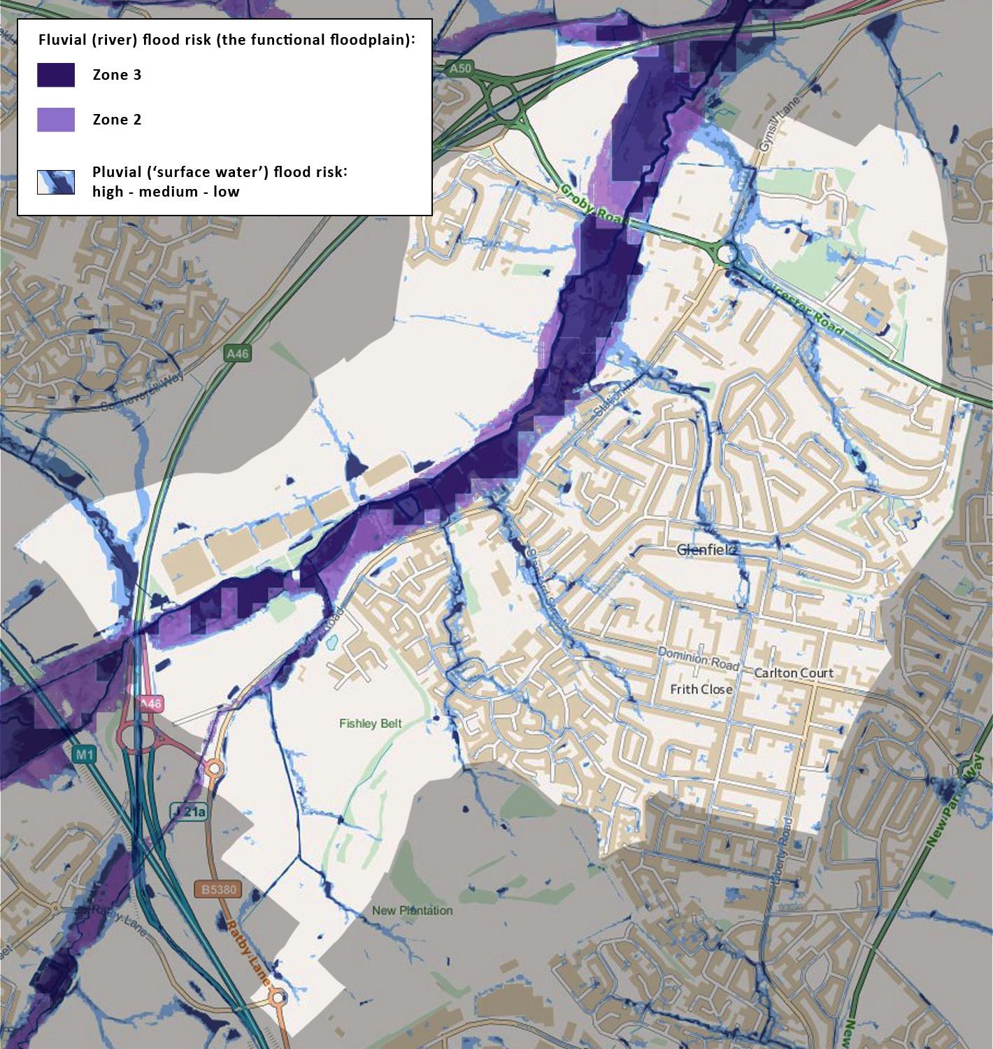
Figure 18: Flood risk from rivers and surface water. Mapping combined from Environment Agency sources
The main residential areas of the Neighbourhood Plan Area are located on high ground with a clay subsoil. Rainwater run-off is naturally relatively fast. Small tributary watercourses flow across these areas into Rothley Brook; they are generally ditched or culverted, but (as shown in figure 18), high rainfall events demonstrably overwhelm this infrastructure to cause localised surface water flooding
49
of high and medium frequency and depth. This is largely the result of rapid run-off from impermeable infrastructure (buildings, paved gardens, commercial sites, roads, etc.) in previous approved developments.
The remaining section of the Plan Area is in the topographic floodplain of Rothley Brook. This is notably broad and flat-bottomed (the result of peri- and post-glacial fluvial erosion and deposition); although the functional modern floodplain occupies only part of this, its boundaries are topographically indistinct – future climate-change related fluvial flood levels are likely, within decades, to exceed the presently-defined Flood Zones 3b, 3a and possibly 2. Large-scale commercial development, with extensive impermeable surfaces (roofs, paved logistics distribution yards, etc.), has been allowed in recent decades, and it should be recognised that flood risk resilience has thereby already been compromised.
In light of this local fluvial and pluvial flood risk susceptibility, it is particularly important that the locations and technical standards of all new development proposals in the Plan Area should in future be judged on their likely contribution to flooding in a climate change world. In parallel, the community will support proposals to improve the infrastructure within the built-up areas for managing flashflooding and surface water run-off events, providing this is not unnecessarily detrimental to the historic built environment, biodiversity sites, or open and green spaces.
This policy supports and is in conformity with NPPF paragraphs 159, 160 and 161, especially (b), and is strongly supported by the 2019 draft National Flood and Coastal Erosion Risk Management Strategy for England, particularly the strategy’s recognition of the need to build flood resilience into future strategic development planning. It is also in general conformity with Blaby District Council Local Plan policies CS 21 and CS 22 and Blaby DC Delivery DPD Site Allocation Policy SA3 (k).
POLICY CC1: FLOOD RISK RESILIENCE – Development proposals in flood risk zones 2 and 3 and within the areas of surface water flood risk indicated in Figure 18 will be required, where appropriate, to demonstrate that the benefit of development outweighs the harm in relation to its adverse impact on national flood resilience strategies or on national and Blaby District Council climate change targets, and that it will not conflict with locally applicable flood resilience strategies and mitigation infrastructure.
Proposals to construct new (or modify existing) floodwater management infrastructure (ditches, roadside gullies, retention pools, etc.), including within the built-up areas, will be supported.
Development proposals for one or more new dwellings and/or for employment development should demonstrate that:
a. if in a location susceptible to flooding from rivers (Zones 3 and 2) or surface water, an alternative site to meet the local residential development need is notavailable b. its location and design respect the geology, flood risk and natural drainage characteristics of the immediate area and is accompanied by a hydrological study whose findings must be complied with in respect of design, groundworks andconstruction c. it includes a Surface Water Drainage Strategy which demonstrates that the proposed drainage scheme, and site layout and design, will prevent properties from flooding from surface water,
50


