
10 minute read
COVER STORY 封面故事
Have you ever wondered where Hong Kong’s original shorelines lie? Discover
how reclamation has led and represented the city’s development over the centuries, with fun and fascinating facts.
Advertisement
Filled to the Hilt Hong Kong’s Fascinating
Reclamation History 香港填海工程史
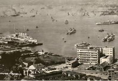
Since the earliest days of the British colony, geographically and economically, Hong Kong has been substantially built on land reclaimed from the sea. Compared with the city’s coastline two hundred years ago, when Hong Kong was still a collection of hamlets and fishing villages, today’s landform is almost unrecognisable.
Expanding territory into the sea has been a human endeavour for hundreds of years, undertaken by countries and cities around the world. The Dutch have extensively reclaimed low-lying areas since the 13th century. In Hong Kong, the infilling of nearby shallow waters has played a pivotal role on the city’s development. In all, more than 6.3%, or around 70 square kilometres, of the city’s total area of 1,106 square kilometres has been reclaimed. But this vital new land accounts for more than 27% of the city’s residential area and supports 70% of its commercial activity.
The city’s eagerness to make its own land was led by its natural geography. Most of Hong Kong Kong’s original coastline was rugged and largely uninhabitable, with villages clinging to slivers of flat space between the mountains and the sea. So when the area around you is mostly level, it is likely the work of man, not nature.
Take a walk with us back through time to explore how reclamation projects have shaped and transformed Hong Kong. By visualising the original geography, we can appreciate the city’s remarkable transformation from remote outpost to one of the world’s great cities.


Hong Kong Island
港岛
Practically all of Hong Kong Island’s northern shore, stretching from Kennedy Town to Shau Kei Wan, stands on land pulled out of Victoria Harbour, its development literally the foundation of the city’s growth over the years. Some notable projects include:
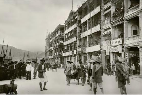
Connaught Road in Central in the 1920s. In the foreground is Blake Pier 1920年代的中環幹諾道中。前面是卜公碼頭

Central Praya Reclamation Schemes 海旁填海计划
from 由 1850s 年代 to 至 1910s 年代
The first road the British built upon taking possession was Queen’s Road, along the shoreline between Sai Wan and Wanchai. The very first reclamation scheme was undertaken in 1851 after a large fire destroyed much of Sheung Wan below Queen’s Road, where the Chinese merchants operated. Using the residual debris plus other rubble, the waterfront line was pushed out from Jervois Street, between Wellington Street and Morrison Street, to a new Bonham Strand, a generous 50 feet wide. Shortly thereafter, the waterfront in adjacent Central was also extended northward, from Queen’s Road to what is now Des Voeux Road Central. In phases over subsequent decades, the sea wall between Central and Sai Ying Pun shifted still further out into the waters of Victoria Harbour, with Connaught Road becoming the new waterfront. Many of today’s landmark buildings in the district, including the Court of Final Appeal building (formerly the Old Supreme Court), Prince’s Building and the Hong Kong Club, then looked out across the harbour.
The harbourfront on Connaught Road around 1920s. Besides shops, quite a number of inns were opened in the area providing accommodation for foreign businessmen visiting in Hong Kong. 1920年左右的干諾道海濱。除商店外,這裡還開設了許多旅館,為香港的外國 商人提供住宿。
3
Connaught Road in Central in the 1920s. In the foreground is the Duke of Connaught statue set opposite Pedder Street. 1920年代的中環幹諾道中, 前面是康諾特公爵雕像,位於畢打街對面。

Wanchai / Causeway Bay 湾仔/铜锣湾
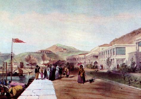
Simply put, much of where you travel in Wanchai and Causeway Bay is reclaimed. To trace the original shoreline, we begin hard up against the hillside, far inland. The first roads built were Queen’s Road East and part of Johnston Road, in front of the small rise where now stands the Ruttonjee Hospital. A jagged headland called East Point reached to where the World Trade Centre now stands, in Causeway Bay. Swampy wetlands formed the shores off today’s Happy Valley and Tai Hang, with a causeway built along the now Causeway Road to keep seawater from flooding the muddy inlet.
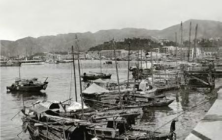
Various reclamation schemes from the late 1800s relentlessly extended the coastline, making Hennessy Road the new waterfront. Further works in the 1950s then laid claim out to the line of Gloucester Road, a stone’s throw from Kellett Island, location of the Royal Hong Kong Yacht Club. In the 1970s, the Wanchai North area was carved out, to be occupied by the Hong Kong Convention and Exhibition, several large commercial complexes and key government buildings. The latest Central and Wanchai Reclamation project created the HKCEC Extension, Bauhinia Square and the infrastructure for the Sha Tin Link and Central-Wanchai Bypass tunnel. For glimpses of the old shoreline, take a walk along Queen’s Road East – for instance, check out Hing Shing Temple and the old Wanchai Post Office.
一句話概括,灣仔和銅鑼灣的大部分地方都由填海建成。你可以通過觀察 山丘起點來追溯最初的海岸線。填海修建的第一條道路是皇后大道東和莊 士敦道的一部分,莊士敦道正對着小山坡上的律敦治醫院。銅鑼灣的東點 成鋸齒狀,現在是世界貿易中心所在地。現時的跑馬地和大坑道原是一片 沼澤濕地,而高士威道旁建有一條堤道,防止海水淹沒泥濘的海岸。早在 19世紀末,各種填海計劃開始不斷擴大土地面積。十九世紀後期進行的大 規模填海工程將軒尼詩路建成了海濱新區;隨後1950年代的填海工程將其 擴展到告士打道,距離香港遊艇會所在地的奇力島僅一步之遙。 1970年 代左右,香港又一次大規模的填海造就了灣仔北地區,也就是香港會展中 心,目前是幾個大型商業綜合體和政府大樓所在地。最新一期中環及灣仔 填海工程包括香港會展中心、紫荊廣場,以及沙田至中環線隧道的基礎設 施建設。
沿着皇后大道東漫步,看看您是否能瞥見昔日的海岸線,還可以參觀皇后 大道東的洪聖廟和舊灣仔郵政局。
1
Spring Gardens, Wan Chai, 1846 1846年,灣仔,春天花園景色
2

Aerial view of Wanchai and Causeway Bay from the Peak around 1925. Landfill works were in progress in Wanchai. 1925年左右,從山頂俯瞰灣仔和銅鑼灣。填海工程進行中。


3
East harbourfront in Wanchai - around 1910 灣仔東海旁-1910年左右
Old Kai Tak Airport / Kowloon Bay / Kwun Tong 旧启德机场/九龙湾/观塘
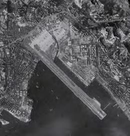
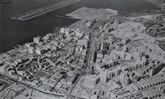
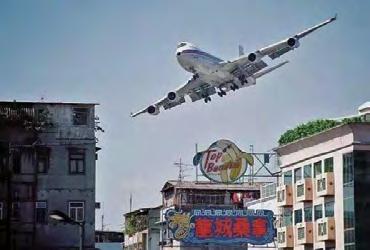
Back in the 1800s, the foothills of Lion Rock Mountain, Kowloon Peak (Fei Ngo Shan) and others comprised of villages built along the shallow shores and mangrove wetlands, with Kowloon Bay forming a natural shelter. Due to rapid growth of refuges from Qing Dynasty China in the early 20th century, plans were drawn to reclaim much of the shallow foreshore and wetlands to create a large residential area. In fits and starts the effort progressed over the decades until the British leased the land for an airfield, eventually expanding into a Royal Air Force Airbase at the now old Kai Tak Airport. The wartime occupying Japanese administration expanded the airport and in the early 1950s, the Hong Kong Government built out a three-kilometre modern runway over the waters of Kowloon Bay and formed a large apron to create a full-fledged civilian airport. At the same time, land was formed from the waters off Kwun Tong to create an industrial area of godowns, shipyards and factories, with more residential areas above. Reclamation off Ngau Tau Kok came next, making way for the current Telford Garden areas south of the foothills. Today, a new reclaimed harbourfront stretching from Kwun Tung to Kowloon Bay is lined with gleaming office buildings and a scenic boulevard. The old airport is well on the way to becoming a major destination, headlined by the Kai Tak Cruise Terminal and a large sports complex being built. But the sleepy bay that once was there is unrecognisable.

1
Kwun Tong Industrial Zone 1966 1966年的觀塘工業區

2
Kwun Tong, early 1960s with Kowloon Bay and the Kai Tak runway in the background 1960年代初的九龍灣觀塘,以九龍灣和啟德跑道為背景

4
Kai Tak at its busiest, in the 1970s 1970年代最繁忙的啟德機場
3
1960s Ngau Tau Kok and Kwun Tong 1960年代牛頭角及觀塘

1
1998 West Kowloon Reclamation viewed from the Peak 1998年山頂俯瞰的西九龍填海區
West Kowloon Reclamation 西九龙填海区
Under the Airport Core Programme of the early 1990s, the West Kowloon Reclamation took out a 3.4-square-kilometre swathe of western Victoria Harbour off Jordan and Tai Kok Tsui. Today, the Western Harbour Tunnel runs through the area, which is also home to the Airport Express Station, the city’s largest mixed-used development, comprised of its tallest office building (ICC), hotels (Ritz Carlton and W Hotel), shopping mall (Elements), a transport exchange (Airport Express and MTR), and swanky high-rise residences. Once the vast West Kowloon Cultural District is completed, the area is set to become the city’s cultural hub. Already well worth visiting, the area includes a scenic promenade, the Xiqu Centre, the Art Park and Free Space.

2

West Kowloon, 1995 1995年的西九龍
New Territories – New Town Development 新界—— 新市镇发展
Sha Tin 沙田
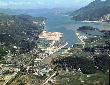
With rapid population growth from the 1950s to the 1970s, consisting largely of arrivals from China and their burgeoning families, the government looked to the New Territories to create satellite towns. When the flat agricultural lands surrounding the villages proved difficult to acquire and consolidate, plans were made to reclaim coastal areas. First came Sha Tin, rising from swampy land beside the Shing Mun River and now home to more than 700,000 people – Hong Kong’s largest satellite town. The creation of other New Territories new towns including Tai Po, Tuen Mun and Ma On Shan also relied largely on reclaimed land.
1
Sha Tin New Town Reclamation, circa 1974 1974年左右的沙田新市鎮
Tseung Kwan O 将军澳
The most recent large satellite development is Tseung Kwan O, an ambitious reclamation project that took in over half of Junk Bay and subsumed shoreline villages including Hang Hau and Rennie’s Mill (Tiu Keng Leng), former home of refugee Kuomintang loyalists. Most of the new town’s 10 square kilometres came from the bay and it now serves as the gateway to the beautiful Sai Kung District hills, scenic beaches and coastline.
1
Tseung Kwan O New Town 將軍澳新市鎮


Lantau
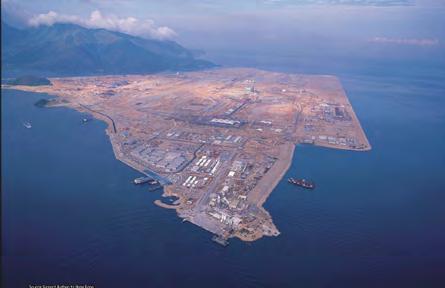
1Hong Kong International Airport Chek Lap Kok Reclamation Circa 1990s 1990年代香港國際機場赤鱲角填海工程
2
Tung Chung New Town Reclamation 1990s 1990年代東涌新市鎮填海工程

大屿山
Hong Kong International Airport / Tung Chung 香港国际机场/东涌
The crown jewel of Hong Kong’s illustrious reclamation projects is surely the 12-square-kilometre Hong Kong International Airport, along with the adjacent Tung Chung new town. The small island of Chek Lap Kok Island, off northwest Lantau island, was levelled and the sea bottom dredged and filled to make space for the new airport. A small hill of Chek Lap Kok was preserved as a sound barrier for the new town of Tung Chung – also reclaimed from the shores and mangrove wetlands of famously hilly Lantau. In the past decade, more reclamation helped create the entry point for the Hong Kong–Zhuhai–Macau Bridge, another engineering marvel in its own right. It is best viewed from the Ngong Ping 360 Cable Car out of Tung Chung and up to the Big Buddha. Other attractions in the area include Sunset Peak and Lantau Peak and the fishing village of Tai O.


