4 minute read
Figure 5: LSPS Structure Plan


SITE
Figure 5: LSPS Structure Plan (site as yellow dot)
Advertisement
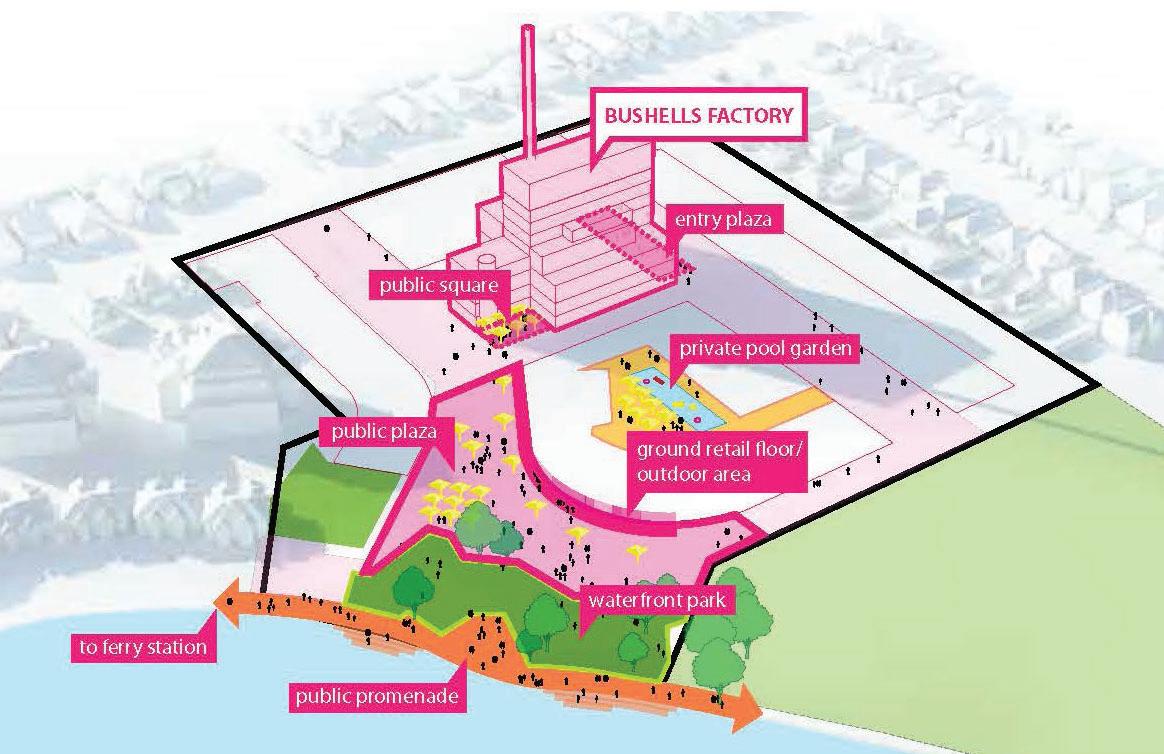
3.1.4 Canada Bay Local Housing Strategy 2021
The Canada Bay Local Housing Strategy (LHS) was endorsed by the Department of Planning, Industry and Environment in May 2021 and analyses the population, demographic and supply issues associated with the delivery and take up of housing in the Canada Bay local government area. The LHS identifi es the site as an opportunity area for the provision of additional residential development.
The strategic principles and objectives of the LPS have been superceded and adopted into the Canada Bay LSPS.
The Canada Bay Local Planning Strategy (LPS) sets out the long term overall strategic land use management and planning objectives to 2031, and aims to ensure that regional strategic planning objectives and major infrastructure projects identifi ed by the State Government are considered at a local level.
The LPS sets out a range of priorities to achieve balanced growth within the LGA, and identifi es objectives and actions relating to improving housing supply and affordability, urban design, employment, transport and infrastructure (including public transport and active transport), open space and recreation, and enhancing to the quality of the natural environment, heritage and the harbour foreshore.
The LPS makes specifi c reference to the subject site as follows: Objective E5 Retain industrial sites within the LGA – this objective supports the retention of the Freshfood site (Bushells) for industrial purposes for the medium term, with further investigation to occur within 10 years (i.e. 2020) Action H6 Consider opportunities for the provision of affordable housing on rezoned sites – over the longer term, Council expects the subject site to be rezoned for other purposes and
accordingly provision of affordable or low cost housing should be explored on this site. With respect to estimated employment land capacity and potential to accommodate future employment, the subject site is identifi ed as having limited take up given that it is an established industrial use and has a peninsular location with poor access and proximity to sensitive residential uses.
Council's approach to land use management of the subject site is broadly refl ected in the ECDP's Planning Priority E12 – Retaining and managing industrial and urban services land, however the LSP sets a timeline for the retention of industrial use on the site.
Where the ECDP's Planning Priority E12 is somewhat of a blanket approach to industrial land across the District, at the local level, Council's LSP foreshadows potential redevelopment of the site and the opportunity for it to accommodate much needed affordable housing in the long term.
Further details and assessment of this amended Planning Proposal against Council's LPS is provided in Section 5.3.2 of this report.
The Parramatta Road Corridor Urban Transformation Strategy (PRCUTS) was released in 2016 and is a 30-year plan setting out how the Parramatta Road Corridor (the Corridor) will grow and bring new life to local communities living and working along the Corridor. The Strategy has been adopted by the NSW Government and is given statutory force by a Ministerial Direction under section 117 (now Section 9.1) of the Environmental Planning and Assessment Act 1979 (NSW).
The Parramatta Road Corridor spans 20 kilometres from Granville in the west to Camperdown in the east and comprises land adjoining and at least one block back from Parramatta Road, as well as Precincts that have been identifi ed as a focus for future growth based on their different functions and character. The precincts include Granville, Auburn, Homebush, Burwood-Concord, Kings Bay, Taverners Hill, Leichhardt and Camperdown.
Whilst the subject site is not within the Parramatta Road Corridor, it is in proximity to the Burwood-Concord and Kings Bay Precincts.
The Burwood-Concord Precinct will be a gateway to Burwood Town Centre based around the enlivened spine of Burwood Road strengthening existing amenity for new residents. It will develop to reinforce it’s role as the major centre for the Corridor, allowing for a greater diversity of housing while maintaining the quality of buildings in the area. It is envisaged to accomodate 11,400 new people, 5,500 new homes and 3,800 new jobs by 2050.
Kings Bay is envisaged as a new residential urban village with a Parramatta Road address. It will have a dense network of streets and an identity built on its proximity to Sydney Harbour. It is envisaged to accommodate 5,200 new people, 2,500 new homes and 2,900 new jobs by 2050.
As discussed in Section 5, proposed future uses on the subject site have the potential to support the foreshadowed growth in these precincts in terms of social infrastructure, public open space and retail and employment offer.
3.1.7 Sydney Green Grid
The Sydney Green Grid sets the framework for the enhancement of open space throughout Metropolitan Sydney. The Sydney Green Grid proposes the creation and consolidation of a network of high quality green areas and waterways that connect town centres, public transport networks and major residential areas and provide hydrological, ecological and recreation services to support sustainable growth keep the city cool, encourage healthy lifestyles, enhance biodiversity and ensure ecological resilience.