28 minute read
Table 9: Consistency with relevant Section 9.1 Directions


Advertisement
The amended Planning Proposal is consistent with the provisions of the former Coastal Management SEPP.
This amended Planning Proposal no longer seeks additional permitted uses on Exile Bay nor is it proposed to enable uses or activities that would compromise the environmental quality of Exile Bay. Future development would need to demonstrate zero net impact on the environmental values of Exile Bay at the Development Application stage.
Sydney Regional Environmental Plan (Sydney Harbour Catchment) 2005
The amended Planning Proposal is consistent with the provisions of the former Sydney Harbour Catchment REP.
The intent for development within this area is to provide for appropriate recreational and similar uses of the foreshore, to rehabilitate or improve degraded foreshores and to protect valuable natural shorelines.
Q6. Is the planning proposal consistent with applicable Ministerial Directions (section 9.1 directions)?
The amended Planning Proposal is consistent with the relevant Ministerial Directions as addressed in the table below. It is noted that the Ministerial Directions numbering was changed on 1 March 2022, with the provisions of each direction remaining the same. The latest direction number at the time of writing this planning proposal is referenced in the table below.
Table 9: Consistency with relevant Section 9.1 Directions
MINISTERIAL DIRECTION AMENDED PLANNING PROPOSAL RESPONSE
1. Employment and Resources
The objectives of this direction are to:
(a) encourage employment growth in suitable locations,
(b) protect employment land in business and industrial zones, and
(c) support the viability of identifi ed centres.
It has been demonstrated in the amended Planning Proposal that the site is unsuitable for continued or intensifi ed industrial use as per the IN1 General Industrial Zone.
A mixed use development on the Subject Site would result in a net loss in land zoned for employment uses however would enable the establishment of a neighbourhood centre that would provide a net increase of 51 jobs in retail, commercial and urban support services roles.
MINISTERIAL DIRECTION AMENDED PLANNING PROPOSAL RESPONSE
Relevant matters include:
Retain existing business and industrial zones The proposed rezoning would result in a loss in industrial zoned land. However the site is isolated from other industrial land, has poor access for heavy vehicles, and is surrounded by low to medium density residential uses, which impact on its ongoing suitability for industrial uses. From a future supply perspective, the subject site represents 13% of existing supply of employment lands (land zoned B5, B6, B7 or IN) in Canada Bay in 2015, but just 0.2% of the supply within the Eastern City District. Notwithstanding, a minimum 3,000m² of light industrial uses/urban services will be provided for in the site.
No net loss of potential fl oorspace for employment uses and related public services in business zones The proposed rezoning is not within a business related zone. Thus it would not result in a potential net loss in fl oorspace related to employment uses and related public services in commercial centres. The development proposes to include 7,000m² of retail and commercial fl oorspace. As such the development results in a net increase in employment and community fl oorspace.
Not reduce the potential fl oorspace area for industrial uses in industrial zones The proposed rezoning would result in a potential loss in fl oorspace that could be utilised for industrial uses, however a minimum 3,000m² of light industrial uses/ urban services will be provided for in the site.
The continued suitability and appeal of the site for industrial use is constrained by the site's peninsular location, poor road access for heavy vehicles and proximity to sensitive residential uses. More broadly, the Inner West industrial market is characterised by low levels of demand and a shift away from traditional industrial uses.
In accordance with a Strategy approved by the Secretary of DPE The proposed rezoning and subsequent mixed use development responds to and accords with the indicative targets for population, housing and employment growth set out in the Greater Sydney Region Plan and the Eastern District Plan.
1.3 Mining, Petroleum Production and Extractive Industries (now Direction 8.1) 1.4 Oyster Aquaculture (now Direction 9.3) 1.5 Rural Lands (now Direction 9.2)
2. Environmental and Heritage
Not Applicable
MINISTERIAL DIRECTION AMENDED PLANNING PROPOSAL RESPONSE
2.2 Coastal Management (now Direction 4.2)
The subject site is located within the Coastal Zone, however it is not within a coastal vulnerability area nor identifi ed as being subject to current or future coastal hazard in an LEP or DCP. Accordingly the proposed increase in development is not inconsistent with this Direction with respect to Direction 2.2 (5).
2.3 Heritage Conservation (now Direction 3.2)
An Aboriginal Due Diligence Assessment has been prepared by Heritage21 (Appendix Q) which provides a summary of the environmental context of the study area, the archaeological background of the site, and a discussion with recommendations arising from the assessment.
The fi ndings of the assessment recommend that:
• In areas where there are existing buildings and the geotechnical information shows no remnant
A Horizon soils there is no need for additional archaeological assessment. There is no impediment to development in these areas on the archaeological grounds and it is recommended that development can 'proceed with caution' as outlined in the due diligence guidelines.
• If ground disturbance is proposed to the depth of the described alluvial soils, consideration should be given to further assessment of these areas.
In the fi rst instance it is recommended that a geomorphologist with experience in assessing soil preservation in archaeological contexts be consulted.
• A copy of this report should be provided to the
Metropolitan Local Aboriginal Land Council for comment.
• On-site employees or contractors involved in ground disturbance should be aware of the statutory obligations that apply to the discovery of Aboriginal objects.
• If Aboriginal objects are uncovered during ground surface works, all works must cease and Offi ce of
Environment and Heritage should be contacted to determine a course of action.
• In the unlikely event that suspected human remains are found all work must cease, the site should be secured and the NSW Police should be notifi ed to advise on a course of action. If the remains are found to be archaeological, OEH and the NSW Aboriginal
Land Council should be contacted to assist in determining appropriate management.
Overall, the assessment considers the potential for Aboriginal objects to be low-moderate. Suitable provisions can be put in place to ensure the conservation of any potential found objects or items.
MINISTERIAL DIRECTION AMENDED PLANNING PROPOSAL RESPONSE
2.4 Recreation Vehicle Areas (now Direction 3.5) 2.5 Application of E2 and E3 Zones and Environmental Overlays in Far North Coast LEPs (now Direction 3.4) 2.6 Remediation of Contaminated Land (now Direction 4.4)
Not Applicable
The planning proposal is consistent with this direction as it will reduce the risk of harm to human health and the environment by adhering to the following recommendations of the Detailed Site Investigation (Round 1) prepared by Geotechnique (Appendix Y). The extract fi nds:
• "Samples should be recovered from a minimum of 50 locations systematically across the site. Only 16 locations had been investigated so far. Completion of investigation for the remaining 34 locations will be required (preferable after completion of the demolition of the factory, the administration building, the transformer room and the gate house).
• Detailed investigation is required after completion of the investigation of the 34 locations in order to delineate the extent of Arsenic concentration of concern identifi ed at BH5, BH2, and BH9.
• Assessment of the soil at and in the vicinity of the existing underground storage tanks will be required to determine the contamination status.
• Groundwater and soil gas investigation would be required.
It is considered reasonable for conditional development consent to be issued to require the above recommendations. It is our opinion that based on this approach Council can be satisfi ed that the site can be made suitable for the proposed uses."
On the basis of the above recommendations and for the purposes of this Planning Proposal, the proposal is considered to satisfy the Direction in this regard. As suggested by the above recommendations, further contamination investigation and determination of remediation action is suitable for, and will be undertaken via a subsequent Development Application.
3. Housing, Infrastructure and Urban Development
3.1 Residential Zones (now Direction 6.1)
The amended Planning Proposal will facilitate future development with the capacity to contribute to the housing supply within the Canada Bay LGA. The Concept Plan proposes a mix of housing types (terrace/ townhouse and apartments), providing housing choice and diversity.
MINISTERIAL DIRECTION AMENDED PLANNING PROPOSAL RESPONSE
The amended Planning Proposal seeks to diversify housing choice by providing a range of permissible residential uses in the R3 Medium Density Residential and B1 Neighbourhood Centre zones. All future DAs on the site would be subject to the provisions of SEPP 65 to ensure good design and amenity.
Being an established and well serviced area, the amended Planning Proposal will enable future development on the site to make effi cient use of the signifi cant road and public transport upgrades to be undertaken along the Parramatta Road Urban Transformation Corridor and the Greater Parramatta to the Olympic Peninsula Priority Growth Area.
3.2 Caravan Parks and Manufactured Home Estates (now Direction 6.2) 3.3 Home Occupations (revoked 9 November 2020)
Not Applicable
The Planning Proposal does not propose any provisions that would preclude home occupations from being carried out in dwellings. It is also noted that this direction was revoked on 9 November 2020.
3.4 Integrating Land Use and Transport (now Direction 5.1)
3.5 Development Near Licensed Aerodromes (now Direction 5.3) 3.6 Shooting Ranges (now Direction 5.4)
4. Hazard and Risk
4.1 Acid Sulfate Soils (now Direction 4.5)
4.2 Mine Subsidence and Unstable Land (now Direction 4.6)
The amended Planning Proposal is consistent with this Direction as follows: the Concept Plan provides greater permeability by the inclusion of new roads and paths to encourage walking and cycling to the Exile Bay foreshore provision of neighbourhood retail / commercial uses provides a walkable alternative to Majors Bay Road shops for residents of the pensinsula
Not Applicable
The majority of the site is identifi ed as Class 5, with a portion along the foreshore identifi ed as Class 2 soils.
The Geotechnical Report (Appendix T) has assessed the potential for Acid Sulfate Soils on the site and provides recommendations for their management.
Not Applicable
MINISTERIAL DIRECTION AMENDED PLANNING PROPOSAL RESPONSE
4.3 Flood Prone Land (now Direction 4.1)
A Flood Assessment Report (Appendix X) accompanies this planning proposal which has undertaken an assessment of the matters specifi ed in Ministerial Direction 4.1. The assessment concludes that it is feasible to implement the requirements of the direction subject to further design development and assessment as part of the Development Application process and will likely be accompanied by a detailed Flood Impact and Risk Assessment.
Accordingly, the provisions of the planning proposal that are inconsistent with the direction are of minor signifi cance.
4.4 Planning for Bushfi re Protection (now Direction 4.3)
5. Regional Planning
Not Applicable
Directions 5.1 – 5.8 (now Directions 1.2, 1.3, 1.17, 3.3, 7.3 and 9.4)
6. Local Plan Making
6.1 Approval and Referral Requirements (now Direction 1.3) 6.2 Reserving Land for Public Purposes (now Direction 5.2) 6.3 Site Specifi c Provisions (now Direction 1.4)
Not Applicable
This is an administrative requirement for Council.
This is an administrative requirement for Council.
The Planning Proposal has been prepared in accordance with the provisions of the Standard Instrument and in a manner consistent with the Canada Bay LEP 2013.
The planning proposal is a minor inconsistency that is essential to achieve the desired outcome which includes uses that do not fi t into a single Standard Instrument zone.
7. Metropolitan Planning
(now Directions 1.6 - 1.16)
This amended Planning Proposal is consistent with the Greater Sydney Region Plan to the extent described at the beginning of this Section 5.3.2 (Q2).
5.3.3 sECTION C – Environmental, Social and Economic Impact
Q7. Is there any likelihood that critical habitat or threatened species, populations or ecological communities, or their habitats, will be adversely affected as a result of the proposal?
The site is urban and can be seen cleared in 1943 aerial photography. There is no indication of identifi ed critical habitat or threatened species, populations or ecological communities, or their habitats.
Q8. Are there any other likely environmental effects as a result of the amended Planning Proposal and how are they proposed to be managed?
Traffi c and Transport
The revised Traffi c Impact Assessment (Appendix F) identifi es that the amended Planning Proposal could generate in the order of 115 movements in the AM peak hour and 115 movements in the PM and Saturday peak hours for the residential component, and 142 movements in the AM peak hour and 283 movements in the PM peak hour for the nonresidential component.
In total, the assessment indicates that the proposed development could generate 257 movements in the AM peak hour and 398 movements in the PM peak hour.
The SIDRA intersection analysis of has been undertaken for the following intersections: Broughton Street/ Zoeller Street/ Ian Parade Broughton Street/ Crane Street Burwood Road/ Crane Street Burwood Road/ Gipps Street Burwood Road/ Parramatta Road
SIDRA intersection analysis of post-development traffi c in year 2019 indicates that all intersections would operate at satisfactory levels (Levels of Service D or better).
The Sydney Strategic Travel Model (STM) shows an increase in traffi c volumes on Burwood Road in 2036 which is likely to be as a result of increased residential growth on the Parramatta Road corridor and within the Peninsula Parramatta Road.
The SIDRA analysis of post development traffi c for the future year 2036 taking into consideration WestConnex shows that the relevant intersections operate within comparable levels of service to their existing operation (acceptable LOS D or better), with the exception of the following intersections: Burwood Road/ Crane Street (LOS E) during PM peak hour; and Burwood Road/ Gipps Street (LOS E) during the AM peak hour.
Accordingly, it is proposed that the project team would work with RMS and Council to agree on operational and physical improvements to mitigate impacts on affected intersections, particularly the Burwood Road/ Crane Street intersection. These may include: Select peak period right turn bans to improve intersection effi ciency where turning movements are currently low. Preliminary consultation with RMS suggests that this may be an appropriate treatment measure. Analysis shows that the intersection would operate within capacity with right turn bans on both the Crane Street approaches (eastern and western leg)
during peak periods in 2036 post development. Further local area traffi c management devices to reduce travel speeds and improve operation. It is noted that Council could consider reviewing some of the local area traffi c management schemes particularly along Broughton Street north of Crane Street, to ensure traffi c control devices meet the needs of future traffi c and access conditions.
Whilst not part of this amended Planning Proposal, consideration for the provision of a connection between Marceau Drive and Crane Street to allow for left-out only movements would improve connectivity and permeability. This would likely result in reduced traffi c demand at the Burwood Road/ Crane Street intersection particularly, as well as at the Burwood Road/ Gipps Street intersection, particularly given that approximately a third of the outbound development traffi c is expected to turn left at Crane Street from Burwood Road.
To reduce private car use, a privately funded shuttle bus service for residents and visitors is proposed. The shuttle bus would operate in a loop through the local area (potentially in both directions) and would provide access to Majors Bay Road Shops, Concord Hospital, Concord Library and Burwood Station. It is anticipated that two vehicles would be used, with an approximate one-hour round trip and therefore half-hour service intervals. It is proposed that the Proponent will fund the operation of the bus route for a period of three years.
Parking can provided to meet requirements on site, predominately in basements to satisfy Council's DCP requirements. Any parking impacts from non-residential uses on the surrounding residential streets could be adequately managed by introducing timed parking in conjunction with a resident parking scheme.
The amended Planning Proposal will have a positive impact on walking and active transport options like cycling by incorporating cyclist and pedestrian access to the new uses on the site. New residents and surrounding residents will be able to access locally serving retail and services within walking distance, reducing the need for some longer predominately car based trips.
Against existing traffi c volumes in the vicinity of the site, the additional traffi c generated by the proposed development could not be expected to compromise the safety or function of the surrounding road network, following implementation of select agreed road network improvements.
Visual Impact
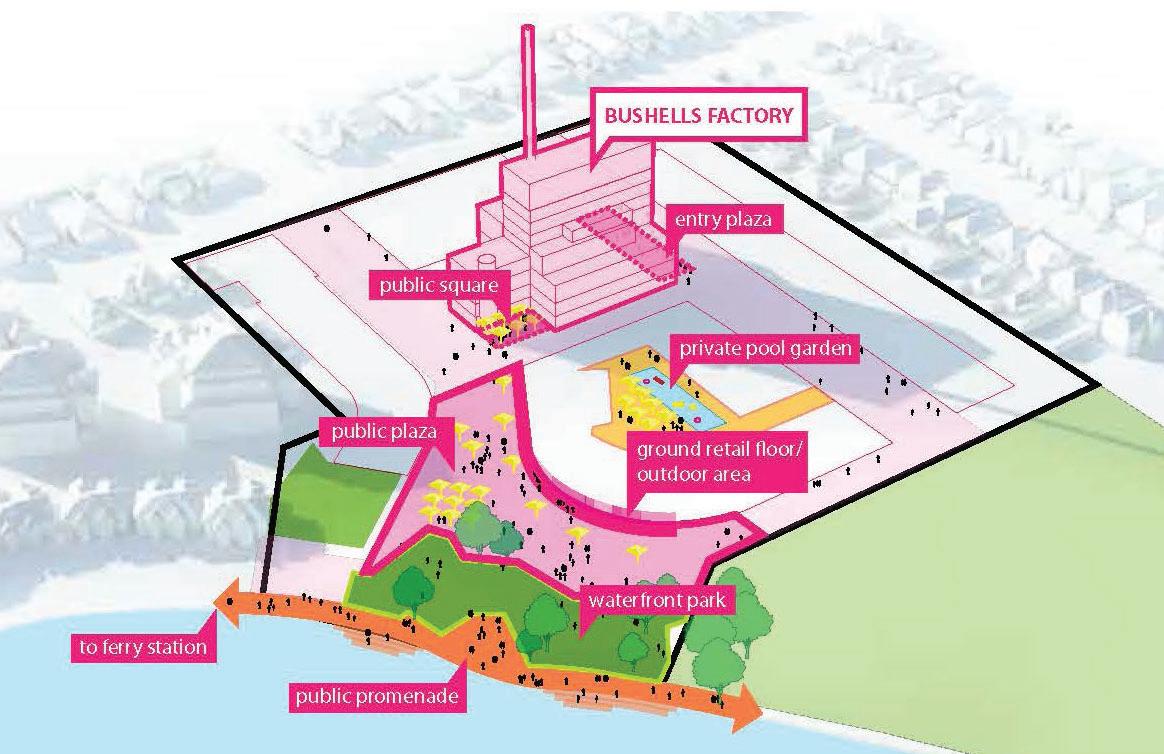
The existing Former Bushells Factory Central Roasting Hall and associated chimney stack will remain as the dominant built form features on the site to ensure the value of the factory as a recognisable landmark.
The amended Planning Proposal provides for new built form around the retained Central Roasting Hall, at approximately half its height or less. Such buildings are less likely to be seen from the surrounds due to existing development and trees.
Views from residences on Duke Avenue will not be adversely impacted, as the 12m side setback provided for in the Concept Plan will enable retention of existing established trees that already screen such views.
Views towards the site from the Burwood Road street frontage will change in appearance, however will not result in view loss to a particular scenic element. Some units in the 6 storey apartment building located immediately east of the site, 162G Burwood Road, currently afford views north-west towards Massey Park Gold Course. These views may be reduced for some residents however units will still afford views north towards Exile Bay which is considered high value.
New buildings as a consequence of the amended Planning Proposal will not cause signifi cant public domain view loss or blocking effects. Primary view loss of key public domain locations
are likely to be restricted to upwards views of open sky. Whilst new buildings will alter the composition of foreground views from close public and private viewing locations, they will not block views to scenic or more highly valued items. The visual impact from when viewed from the across the bay (north and east of the site) may also be reduced with careful selection of materials and fi nishes.
Additionally, new locations to view the Exile Bay and Parramatta River will be created by the proposed new public roads and open space on the site.
Overshadowing
The potential overshadowing impacts of the amended Planning Proposal are outlined in the Concept Plan, Analysis and SEPP 65 Certifi cation prepared by AJ+C (Appendix C) as follows: Solar access to properties west of the site may result in a minor reduction in the morning.
However much of the shadow impact will be contained within shadows of existing trees. Properties south of the site will not experience impact of overshadowing as a result of the proposal. Properties to the east of the site may result in some reduction to afternoon sun light after 2pm at the winter solstice. The impact on existing buildings may be minimised through careful building massing and articulation.
Any overshadowing impact would be need to be confi rmed as part of the Development Application process. Notwithstanding, any future development would need to comply with the provisions of SEPP 65.
Solar Access
The Concept Plan, Analysis and SEPP 65 Certifi cation (Appendix C) provided by AJ+C outlines the solar access compliance of indicative apartment and communal open space locations as per the requirements of Apartment Design Guide Objective 4A of Schedule 1 of SEPP 65.
Visual and Acoustic Privacy
The Concept Plan provides for adequate separation distances between residential buildings. It is expected that visual and acoustic privacy would be addressed at the Development Application stage.
Public Domain
The amended Planning Proposal will positively contribute to the public domain by providing new public open space in the form of a waterfront park. This new open space will provide improved waterfront connections from Bayview Park in the east to Prince Edward Park in the north.
The proposed public domain on the site will be well connected to the local area through the provision of pedestrian links from Burwood Road and Zoeller Street.
The Concept Plan provides for a plaza addressing ground fl oor retail / commercial uses, thereby encouraging street activity.
Tree Retention
The amended Planning Proposal will enable the retention of the existing landscaping along the eastern and western boundary of the site, and the trees within the north east portion of the site, notably the Hills Fig Tree. To ensure protection and suitability trees to be retained an Arboricultural Assessment Report has been prepared (Appendix G) .
Loss of existing tree canopy will be mitigated with new planting on the site. The Concept Plan provides for new planting along streets and deep soil areas such as the proposed public foreshore park. A minimum of 25% urban tree canopy can be achieved according to the Concept Plan.
Stormwater
Council’s requirements for stormwater management including fl ood mitigation, water reuse, water sensitive urban design, water quality control, and environmental protection can be provided for on-site. Building roof stormwater runoff will be harvested for re-use in non-potable uses where possible.
The underground drainage network can been designed to contain the major (100yr ARI) storm, and emergency overland fl ows paths have been designed to avoid local nuisance fl ooding to site buildings and neighbouring properties.
It is anticipated that all low fl ows (<Q1) will be conveyed to a centrally located water quality treatment system to reduce target pollutants of suspended solids, total phosphorous, and total nitrogen, sediment and gross pollutants. Discharge points are proposed to remain unchanged or be altered to improve discharge conditions.
The above issues would be formally addressed at the Development Application stage.
Flooding
Council's draft Exile Bay Study 2020 quantifi es the existing fl ood behaviour on the site with peak fl ood levels in the vicinity of the development as: 1% Annual Exceedance Proability (AEP) of 3.6m - 8.4m AHD, and Probable Maximum Flood level of 3.7m - 8.6m AHD.
The majority of the development is subject to low hazard fl ooding and is affected by low magnitude overland fl ow. In the 1% AEP event, this is in the order of 1.6m3/s which is feasible to convey in either an above of below ground stormwater system.
The Flood Assessment Report (Appendix X) fi nds that the indicative concept is feasible with regard to the requirements of Council's LEP and DCP and subject to further design development and assessment as part of the Development Application process.
Contamination, Geotechnical and Groundwater
A preliminary (Appendix R), additional (Appendix S) and detailed (Round 1) (Appendix Y) Site Contamination Assessments have been prepared for the site which conclude that based on the soil samples assessed on the site are generally unlikely to pose a risk of harm to human health and the environment. Arsenic concentration at one test location was marginally higher than risk based Health Investigation Level B. This has been identifi ed as a hot spot for further investigation and remediation. Some acidic soils were also detected which may infl uence the footings of structures.
It is anticipated that if excavation extends below the groundwater level (most likely to be RL 0), dewatering may be required, and a specialist dewatering contractor should be contacted during basement excavations.
As basements levels form part of the Architectural Concept Plan, further investigations of groundwater conditions under the site would be carried out as part of any future Development Application based on the recommendations of the Geotechnical Investigation Report prepared for the site.
Q.9. Has the amended Planning Proposal adequately addressed any social and economic effects?
Housing Supply
The amended Planning Proposal enables a range of housing products to be developed on the site to positively contribute to housing supply within Concord and Canada Bay Local Government Area.
The Concept Plan provides for approximately 400 dwellings, 10% of which will be provided as affordable housing in accordance with a draft Affordable Rental Housing Scheme prepared by Council.
Industrial Land Supply
The Economic Impact Assessment (Appendix O) concludes that given the low levels of demand and new lease activity for the industrial market within the Inner West, and the site’s location on Parramatta River surrounded by residential uses with poor heavy vehicle access and isolation from other industrial uses, it is unlikely that the industrial use of the site will continue past its current use. Notwithstanding, the Planning Proposal makes provision for light industry uses within the B1 Neighbourhood Centre zone that will enable a range of emerging 'urban services' to occur that support the local community and refl ect the changing uses and character of employment lands in Eastern Sydney.
In addition, the EIA identifi es several economic benefi ts of the amended Planning Proposal: New employment creation; Additional economic activity during the period of construction, stimulating investment in the locality; and Increased proportion of residents living close to employment, retail facilities, amenities and public transport.
Retail Supply
The amended Planning Proposal seeks the rezoning of part of the site to B1 Neighbourhood Centre to enable commercial premises including, but not limited, to neighbourhood shops and neighbourhood supermarkets.
The Retail Demand Assessment prepared by Hill PDA (Appendix P) suggests at total retail fl oor area of approximately 3,000m2 with a retail mix is as follows: Approximately 800 to 1,000m2 supermarket (small format Coles or Woolworths, IGA, Harris
Farm or similar) 200sqm to 400m2 of specialty food (liquor, bakery, butcher, confectionery, coffee, etc) Approximately 800m2 of restaurants and fast food/take-aways Approximately 500 to 800m2 of non-food retailing and personal services (newsagency, arts, hair and beauty, chemist, etc)
Following the recommendations of the SECPP, there will be ample fl oorspace to accommodate the above retail uses and mix, given the minimum provision of 7,000m² of non-residential fl oor space on the site. The Retail Demand Assessment has found $18.7m out of $35m growth in the walkable catchment of site between 2016 and 2031 would be captured by retail as proposed in the Concept Plan. The proposed centre is justifi able based on growth alone and would not be reliant upon redirecting signifi cant trade away from existing centres.
The redevelopment of the subject site provide economic benefi ts in terms of attracting additional retail spend to the area. The proposed extent of retail is aimed at serving the local population but will not take signifi cant trade away from existing centres and will encourage active transport to convenience retail.
Heritage
A Statement of Heritage Impact (Appendix K) has been prepared which found that: The following aspects respect the heritage signifi cance of the items in the vicinity: –The redevelopment does not propose to alter the curtilage or the physical fabric of the surrounding heritage items; –Redevelopment would interpret of the site's distinct character within the local area; –The views between the subject site and the heritage items would remain largely consistent with views from the heritage items dominated by the highest elements of the subject site; –The proposed higher built forms would be located in the centre of the site which would minimise the visual impact of the proposed building on the existing views, particularly from Concord Road, the waterfront and Massey Park Golf Course; –The redevelopment would encourage and facilitate ongoing social use of the heritage items; and –Landscaping elements make reference to the nature of the surrounding heritage items and would reinvigorate the local area, particularly through the creation of a publicly accessible foreshore park. There are no aspects of the proposal which could be detrimental to the signifi cance of the heritage items in the vicinity.
The SoHI concluded that the proposed development would positively contribute to the surrounding heritage items by encouraging and facilitating their ongoing use and appreciation. By locating the taller building heights in the centre of the site, visual impact of any future development on the nearby heritage items, the waterfront and the streetscape would be minimised.
It is recommended that the Former Bushells Factory Building be listed as an item of environmental heritage in CBLEP 2013. The signifi cance of the subject site is attributed to the Former Bushells Factory Building, including the chimney stack, the 'B' facade, and the landscaped setting.
Heritage Setting The most important aspects to the current heritage setting are: A visually prominent Central Roasting Hall building; and The characteristic industrial landscape setting.
The visual prominence of the Central Roasting Hall building, most importantly as seen from the foreshore round, will be retained by ensuring that the maximum height of new buildings does not exceed 21m (6 storeys), which is approximately half the height of the existing building.
The industrial landscape setting, which is typical of Inter-War and Post-War industrial complexes in Sydney, will be maintained in terms of the grassed areas surrounding the retained building and the proposed foreshore park.
Adaptive Reuse The Former Bushells Factory Building is proposed to be retained, conserved and adaptively reused to accommodate residential, retail, commercial and community uses in a manner that will not alter the exterior or interior spaces, except where the upper fl oors are to be converted for residential use. All prominent structural elements, including beams, columns and large internal open area, are to be maintained. This is consistent with adaptive reuse principles of allowing the building's structure and form to be maintained without having to remove, alter or demolish a signifi cant amount of original fabric.
The prominent glazed elements of the northern and southern façades of the factory building will be maintained as an element. Due to BCA and NCC requirements, the existing glass and aluminium framing cannot be retained, however a contemporary style of curtainwall glazing would be introduced that reads closely to that which already exists. A wintergarden is proposed that establishes a secondary line to glazing to minimise impacts of the glazed components of the tower and to meet the specifi c requirements for residential use.
Social Infrastructure
The amended Planning Proposal will have a positive impact on the community as it responds to the needs that were identifi ed within the Social Infrastructure and Community Uses Demand Assessment (Appendix W).
The amended Planning Proposal seeks to enhance the amenity and public domain of the subject site and surrounding areas via landscaping improvements and the provision of public open space and in turn, increased levels of activity.
The linkages of the site with surrounding uses and facilities would promote a positive fl ow on effect to the broader community to the benefi t of social health and well-being. The co-location of open space and retail facilities on the subject would have a positive impact on the use of the neighbouring Bayview Park and Hen & Chicken Bay Foreshore Walk. The through site link would also increase accessibility from neighbouring Bays, particularly for cyclists, which would have positive benefi ts in terms of social health and well-being.
5.3.4 SECTION D – STATE AND COMMONWEALTH INTERESTS
Q10. Is there adequate public infrastructure for the Amended Planning Proposal?
Public Transport
According to the Traffi c Impact Assessment (Appendix F) the amended Planning Proposal is likely to result in development with occupants that will increase demand for the bus services that connect the site to key destinations such as Burwood Train Station and Town Centre.
The recent re-routing of the 466 bus route to travel to the northern end of Burwood Road and frequent services in the peak hour (services every 15 minutes) will help to accommodate the increase in population in the area. The 466 bus provides a connection to Burwood Station where commuters can transfer to the T1 North Shore, Northern and Western Line or T2 Inner West Line and Leppington Line, providing connections to other parts of Sydney including the CBD.
Utilities
The site is within an established urban area, with all urban services provided to the site. While the proposal may require the upgrading of service facilities such as water, electricity or sewer to cater for the proposed increase in density, these can be addressed as part of a future Development Application.
Open Space
The site is well serviced by recreational open spaces with a number of public open space and facilities within walking distance including Bayview Park and Hen & Chicken Bay foreshore walk.
The Concept Plan provides for a new public foreshore park and the enhancement of the Exile Bay frontage (to be rezoned as RE1 Public Recreation).
Health and Education
The site is relatively well-serviced by a range of health facilities with 14 health facilities located within a 2 km radius of the site, included services such as medical centres, physiotherapists, pathologists, orthopaedics, and dental services. Two community health facilities, the Concord Early Childhood Health Centre and the Five Dock Early Childhood Centre, are located within a 2 km radius of the site. The Concord Repatriation General Hospital is located approximately 3km north west of the site.
Similarly, there are a number of primary and secondary educational facilities within 2 km of the site, including seven primary schools and fi ve secondary schools.
Accordingly, it is anticipated that there are adequate health and education facilities and infrastructure in the local area and the wider LGA to support the amended Planning Proposal.
Q11. What are the views of state and Commonwealth public authorities consulted in accordance with the Gateway determination?
Appropriate consultation with relevant government agencies will be undertaken as required by Condition 4 of the Gateway Determination.