Appendix A: Designation Conditions
CRL Designation Conditions
29 October 2019
Aotea Alteration: BROWN (confirmed 24 January 2017)
Condition 27.1(b) (Swanson St diversion): ORANGE (confirmed 23 June 2017)
Strata/Sub-Strata Alteration: GREEN (confirmed 22 September 2017)
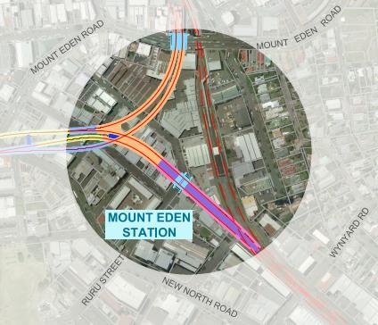
Mt Eden CRL and NAL Alteration: BLUE (Environment Court Decision 15/12/17)
Condition 27.1(b) (second Swanson St diversion): PINK (confirmed 27 March 2018)
Operational Vibration Conditions 63 & 66:
PURPLE (confirmed 24 July 2018)
Karangahape Station Alteration: RED (Environment Court Decision 12 April 2019, upheld by High Court Decision 25 October 2019)
Explanatory Note:
The following explanatory note does not form part of the conditions.
It is a non-statutory way finding explanation of how the conditions are structured, what they cover in broad terms and where referenced documents can be found.
This note does not alter legal obligations and rights created by the conditions.
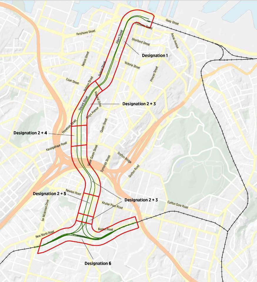
The conditions attach to six different designations. The designations are:
2500-1
2500-2
2500-3
2500-4
2500-5
2500-6
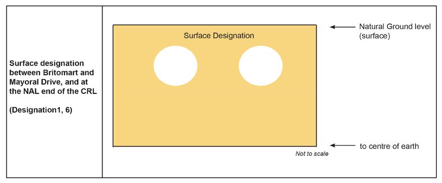
A surface designation extending from Britomart Transport Centre to Albert Street/Mayoral Drive (in the vicinity of the Aotea car park entrance on Mayoral Drive) for the construction, operation and maintenance of the CRL – including two rail tunnels and Aotea Station.
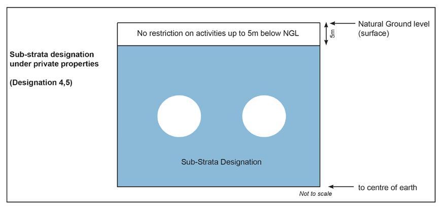
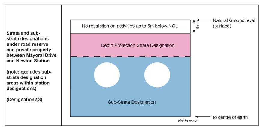
A sub-strata designation of land below the ground surface (within road resource and private property) for the construction, operation and maintenance of the CRL –including two rail tunnels and ancillary activities. This designation sits underneath the strata (protection) designation 2500-3 and extends from Mayoral Drive to New North Road.
A strata (protection) designation that acts as a buffer between activities on the ground surface and the sub-strata designation (2500-2) that provides for the two rail tunnels. This designation sits above designation 2500-2, starting from 5 metres below the ground surface, and extends from Mayoral Drive to New North Road.
A surface and sub-strata designation for the construction, operation and maintenance of Karangahape Station, and encompassing land within road reserve and private property in the vicinity of Pitt Street, Beresford Square, Karangahape Road, and Mercury Lane.
A surface and sub-strata designation for the construction, operation and maintenance of Newton Station, and encompassing land within road reserve and private property in the vicinity of Symonds Street, Dundonald Street, and New North Road.
A surface designation for the construction, operation and maintenance of the CRL –including the rail tunnels and connections required to join the CRL to the North Auckland Railway Line (NAL). This designation is located generally between New North Road, Mt Eden Road and Boston Road in the north and the NAL in the south. It also includes land located on the southern side and adjacent to the NAL between Normanby Road and Mt Eden Road, and to the imm ediate east and west of Porters Avenue.
Hereafter for the purpose of this condition set the designations are referred to as 1, 2, 3, 4, 5 and 6.
The table of contents for the conditions provides a broad overview of the subject matter. It commences with definitions and abbreviations and progresses to general conditions applicable to all designations followed by the conditions for pre-construction, construction, and operation. Under each of these
headings may be found sub-headings dealing with specific aspects of the work. There follow advice notes and appendices for:
- buildings for consideration as to building condition surveys; and
- heritage buildings for consideration as to building condition surveys
The conditions for designation 3 conclude the suite of conditions.
Set out below are a series of figures illustrating and explaining the location, extent and nature of designations 1 – 6. For precise details, please refer to the relevant designation overlays within the planning maps.
Figure 1: Designations Overview Map
The map below is not to scale and is intended as a visual tool only to show the location of each designation. The Land Requirement Plans and associated Schedule of Directly Affected Parties (attached to each designation) should be referred to for the actual area of land required.
Figure 2: Visual explanation of the designation types
Surface Designations
Sub-strata Designations
Strata Designation with Sub-strata Designation below
Figure 3: Indicative long-section of the designations across the length of the CRL
The relationship between the various plans required by designation conditions is illustrated in the diagram below:
The documents referred to in the designation conditions can be found at [insert]
Requiring Authority Designation Conditions – for Designations 1, 2, 4, 5 and 6
DEFINITIONS
GENERAL CONDITIONS
Condition 1
Condition 2
Condition 3
PRE-CONSTRUCTION CONDITIONS
Condition 4 – Appointment of Communication and Consultation Manager
Condition 5 – Pre-Construction Communication and Consultation Plan
Condition 6 – Network Utility Operators
Condition 7 – Community Liaison Groups
Condition 8 – Mana Whenua Consultation
Condition 9 – Network Utility Operator Liaison
CONSTRUCTION CONDITIONS
Condition 10 – Outline Plan Requirements
Condition 11 – Independent Peer Review of CEMP and DWPs
Condition 12 – Availability of Outline Plan(s)
Condition 13 – Monitoring of Construction Conditions
Communication and Consultation
Condition 14 – Contact Person
Condition 15 – Communication and Consultation Plan
Condition 16 – Communications – Notable Noise and Vibration Receivers
Condition 17 – Concerns and Complaints Management
Condition 18 – “One Network” Consultation
Construction Environmental Management Plan (CEMP) and Delivery Work Plans (DWPs)
Condition 19 – Preparation, Compliance and Monitoring
Condition 20 – CEMP Requirements
Condition 21 – CEMP Construction Works Requirements
Condition 22 – Review Process for CEMP and DWPs
Condition 23 – Update of CEMP and DWPs following review
Condition 24 – Network Utilities
Transport, Access and Parking
Condition 25 – General Transport, Access and Parking
Condition 26 – Monitoring of Transport Network Congestion
Condition 27 – Transport, Access and Parking: Specific Requirements (Britomart to Mayoral Drive)
Condition 28 – Transport, Access and Parking: Specific Requirements (Karangahape Station Area)
Condition 29 – Transport, Access and Parking: Specific Requirements (Newton Station Area)
Condition 30 – Transport, Access and Parking: Specific Requirements (NAL Area)
Noise and Vibration
Condition 31 – Project Standards – Construction Noise
Condition 32 – Project Standards – Blasting Noise
Condition 33 – Project Standards – Construction Vibration
Condition 34 – Project Standards – Construction Vibration (Amenity)
Condition 35 – Project Standards – MediaW orks
Condition 36 – Construction Noise and Vibration DWP
Condition 37 – Site Specific Construction Noise Management Plan (SSCNMP)
Condition 38 – Site Specific Construction Vibration Management Plan (SSCVMP)
Condition 39 – Notable Noise and Vibration Receivers
Condition 40 – Construct ion Noise and Vibration Management Plan – MediaW orks
Built Heritage/Archaeology
Condition 41 – Historic Character – Built Heritage
Condition 42– Historic Character – Archaeology
Condition 43 – Heritage Advisory Group and Composition
Condition 44 – Heritage Advisory Group Function
Condition 45 – Bluestone Wall Management Plan
Building Condition Surveys
Condition 46 – Process for Building Condition Surveys
Urban Design
Condition 47 – Urban Design Principles
Condition 48 – Mitigation Planting Requirements
Condition 49 – Engagement with Mana Whenua and the Mana Whenua Principles
Condition 50 – Specific Area Requirements: Britomart to Aotea Station
Condition 51 – Specific Area Requirements: Karangahape Station area
Condition 52 – Specific Area Requirements: Newton Station area
Condition 53 – Specific Area Requirements: North Auckland Line area
Condition 54 – Station Plan Requirements
Trees and Vegetation
Condition 55 – Trees and Vegetation DWP
Public Art
Condition 56 – Public Art DWP
Contamination
Condition 57 – Contamination DWP
Condition 58 – Contamination Validation Report at Completion of Construction
Air Quality
Condition 59 – Air Quality DWP
Social Impact and Business Disruption
Condition 60 – Property Management Strategy
Condition 61 – Social Im pact and Business Disruption DWP
Specific Design Requirements
Condition 62 – Specific Design Requirements relating to 152 Vincent Street
OPERATIONAL CONDITIONS
Condition 63 – Operational Rail Vibration
Condition 64 – Operational Noise – Mechanical Ventilation Plant
Condition 65 – Operational Noise and Vibration Management Plan (ONVMP)
Condition 66 – Operational Noise and Vibration Management – Mediaworks
ADVICE NOTES
APPENDIX ONE – Buildings for Consideration as to Building Condition Surveys
APPENDIX TWO – Heritage Buildings for Consideration as to Building Condition Surveys
ADVICE NOTES
Requiring Authority Designation Conditions – for Designations 1, 2, 4, 5 and 6
DEFINITIONS 1 2 4 5 6 Consult Consulting Consultation
1 4 5 6
1 4 5 6
Fully operational traffic lane
The process of providing information about the construction works, and receiving for consideration, information from stakeholders, directly affected and affected in proximity parties, regarding those effects and proposals for the management and mitigation of them.
May include a traffic lane that is subject to a reduced speed limit, or one which may have a temporary reduction in the lane width, due to construction activity.
Two way access
1 2 4 5 6 Notable Noise and Vibration Receivers
Access into and out from a site or a road. This access may include restrictions (eg. left in, left out) where these are specified within the relevant conditions.
Receivers that undertake activities within spaces that rely on a particularly low noise and vibration environment. For these designations these spaces are defined as:
• Public Performance Theatres;
• Recording Studios, both sound and television (including Mediaworks, except the specific spaces addressed by Condition 35);
• In relation to sensitive equipment - Medical Facilities and Scientific Laboratories;
• In relation to the requirement to record witness statements - The Auckland District Court in Albert Street 1 2 4 5 6 Sensitive Noise and Vibration Receivers
Receivers that may be disturbed during rest, concentration, communication or prayer. For these designations these include (but are not limited to):
• Dwellings
• Offices
• Schools, including Child Care Centres and tertiary facilities
• Libraries
• Hospitals
• Rest Homes
• Marae and other Cultural Centres
• Churches
• Hotels or other accommodation facilities
1 Site Specific Construction
These include site specific construction noise management plans (SSCNMP), site specific construction vibration plans (SSCVMP), or a
2 4 5 6
Noise and Vibration Management Plans
1 2 4 5 6 Best practicable option
1 2 4 5 6 Historic Character
combination of both noise and vibration in one plan (SSCNVMP) to address the effects from the construction activity on notable or sensitive receivers
1 2 4 5 6 Mana Whenua
Has the meaning under the Resource Management Act 1991 and, for the purpose of these conditions, comprises the best practicable option for minimising the effects of any construction activity (including effects on the transport network or heritage values) on the receiver.
This includes heritage buildings, sites and places identified in the New Zealand Historic Places Trust register or in the Auckland Council District Plan (Isthmus or Central Area Sections) or as specifically identified in conditions.
Mana whenua for the purpose of this designation are considered to be the following (in no particular order), who at the time of Notice of Requirement expressed a desire to be involved in the City Rail Link Project:
• Ngati Maru
• Ngati Paoa
• Ngai Tai ki Tamaki
• Ngati Te Ata
• Ngati Whatua o Orakei
• Te Akitai
• Te Kawerau o maki
• Ngati Tamaoho
1 2 4 5 6 Material change
1 2 4 5 6
Delivery Work Plans
Material change will include amendment to any base information informing the CEMP or other Plan or any process, procedure or method of the CEMP or other Plan which has the potential to materially increase adverse effects on a particular receiver For clarity, changes to personnel and contact schedules do not constitute a material change.
Delivery Work Plans will contain specific objectives and methods for avoiding, remedying or mitigating effects and address the following topics:
(a) Transport, Access and Parking;
(b) Construction noise and vibration;
(c) Historic Character (including Archaeology);
(d) Urban Design (including landscape and station plans);
(e) Trees and vegetation;
Condition Number NoR Designati on Applies to Condition
(f) Social Impact and Business Disruption; (g) Air quality;
(h) Public Art; and (i) Contamination. 1 2 4 5 6 Peak Particle Velocity
The maximum component peak vibration level (in mm/s) measured in any of three orthogonal axes (vertical, transverse, longitudinal).
6 MediaWorks
6 MediaWorks site
MediaWorks means any television, radio and/or interactive media facilities which broadcast from the MediaWorks site (including any successor which conducts the same activities).
MediaWorks site means the properties at 2-3 Flower Street and 44-52 New North Road included within the following:
Lot 1 DP 84213
Lot 2 DP 49561
Lot 4 Section 3 Deeds Plan 45(blue)
Part Lot 5 Section 3 Deeds Plan 45 Blue
Lot 1 DP 60771
6 MediaWorks buildings
6 Studio 1
ABBREVIATIONS
NA40B/1323
NA2063/54
NA557/190
NA557/144
NA15C/727
MediaWorks buildings means the buildings located at 2 Flower Street (Lot 2 DP 49561, NA2063/54), 3 Flower Street (Lot 1 DP 84213, NA40B/1323), 40 New North Road (Lot 1 DP 80372, NA37A/545), 44 New North Road (Lot 4 Section 3 Deeds Plan 45 (Blue), NA557/190), 4648 New North Road (Pt Lot 5 Section 3 Deeds Plan 45 (Blue), NA557/144), and 52 New North Road (Lot 1 DP 60771, NA15C/727).
Studio 1 means the main broadcasting studio at the MediaWorks building at 3 Flower Street as shown on Diagram 1.
CEMP Construction Environmental Management Plan
DWP Delivery Work Plan
NoR Notice of Requirement
ONVMP Operational Noise and Vibration Management Plan
PPV Peak Particle Velocity
SSCNVMP Site Specific Noise and Vibration Management Plan
1.1 The City Rail Link Project (City Rail Designations 1, 2, 4, 5 and 6) shall be undertaken in general accordance with the following, subject to final detailed design:
(a) the information provided by the Requiring Authority in the Notice of Requirement dated 23 August 2012 and supporting documents (as updated by information provided by the Requiring Authority up until the close of the Hearing and during the course of Environ ment Court proceedings) being:
(i) Assessment of Environmental Effects report (contained in Volume 2 of the Notice of Requirement suite of documents, dated 15 August 2012 Rev B);
(ii) Supporting environmental assessment reports (contained in Volume 3 of the Notice of Requirement suite of documents, dated August 2012);
(iii) The Concept Design Report (contained in Volume 2 of the Notice of Requirement suite of documents, dated 13 August 2012 Rev 3);
(iv) Plan sets:
• Land requirement plans (contained in Volume 1 of the Notice of Requirement suite of documents, dated 15 August 2012 and GIS4214293-100-10 Rev 5 as amended for 32 Normanby Road, dated 14 September 2015);
• Plans contained in the Concept Design Report Appendices (contained in Volume 3 of the Notice of Requirement suite of documents, dated 13 August 2012 Rev 3);
• Plan CIV-000-DRG-0001 attached at Appendix 1 to these Conditions.
(v) Information provided in response to the Section 92 requests and/or in advance of the Council’s section 42A report, including the following:
• “City Rail Link Notice of Requirement: Social Impact Assessment” prepared by Beca Carter Hollings & Ferner Ltd (Beca), dated 19 April 2011 (approved for release 19 April 2013);
• “City Rail Link – Supplementary Report: Traffic Modelling of Alternative Construction Scenarios” prepared by Flow Transportation Specialists Ltd, dated 22 May 2013.
(vi) Evidence (including supplementary evidence) provided prior to and at the Council hearing, including but not limited to:
• Statement of Evidence by Ian Clark (Transport) dated 2 July 2013;
• “Drawing 0220, Revision B” dated 20 August 2013, being part of the City Rail Link Project: Mt Eden Worksite set by Aurecon, submitted as part of the Second Supplementary Statement of Evidence of William (Bill) Russell Newns for Auckland Transport;
• “City Rail Link Notice of Requirement: Outline Plan Process and Environmental Management Plan System (Indicative)” prepared by Beca Carter Hollings & Ferner Ltd, dated 27 September 2013;
• “City Rail Link: Indicative Communication and Consultation Plan” prepared by Auckland Transport, dated September 2013;
• “Outline Social Impact and Business Disruption Delivery Work Plan” submitted as Attachment A to the Statement of Evidence of Amelia Joan Linzey (Beca Carter Hollings & Ferner Ltd), dated 26 September
Condition Number NoR Designati on Applies to
Condition 2013.
(vii) All material and evidence (including rebuttal evidence) provided by the Requiring Authority in the Environment Court proceedings (ENV-2014-AKL -000057).
(b) Except as modified by the following alterations:
(i) Assessment of Environmental Effects (Reference CRL -AOT-RME-000-0057), Design and Construction Report (Reference CRL -AOT-RME-000-0059 and Drawings CRL¬ SYW-RME-000- DWG-0025-0030 (‘Aotea Alteration’ - CRL Designation 1); and
(ii) Assessment of Environmental Effects (Reference CRL -SYWRME-000-RPT-0065, Design and Construction Memorandum (Reference CRL-SYW- RME-000-MEM0002) and Drawings CRL-SYW- RME-000-DRG-0120 to 0124 and 0128 to 0132 ‘Strata / Sub-Strata Alteration (CRL Designation 2); and
(iii) Assessment of Environmental Effects (Reference CRL -MTE -RME- 000-RPT-0060, Revision 7 dated 9/11/16), Design and Construction Memorandum (Reference CRL-MTE-RME-000-MEM-0001, dated 9/11/16) and Drawings CRL -SYW-RME000-DWGDRG-0101 Revision 1 dated 26/7/16, 0102 Revision 1 dated 26/7/16, 0110 Revision 1 dated 26/7/16 and 0133 Revision 1 dated 26/7/16 and CRL -EFCROA-000-DRG-1027 Revision 4 dated 30/6/16, 1028 Revision 4 dated 30/6/16 and 1127 Revision 2 dated 30/6/16 and CRL -EFC-CON-000-DRG- 0060 Revision 1 dated 20/6/16, 0061 Revision 1 dated 20/6/16, 0062 Revision 1 dated 20/6/16, 0063 Revision 1 dated 20/6/16 and 0064 Revision 1 dated 8/7/16)(‘Mt Eden Station Alteration’ - CRL Designation 6), Section 92 responses dated 20/12/16, 17/2/17 and 27/4/17;
(iv) Assessment of Environmental Effects (Reference CRL -PAT-ENV-CON -PLN-003285, Revision 2 dated 19/12/17, Section 92 Responses dated 19/2/18.
(v) Assessment of Environmental Effects (Reference CRL -KRD-RME-000-RPT-003, Revision 3.0 dated 2/5/17), Design and Construction Memorandum (Reference CRL-KRD-RME-000-MEM-0002 FINAL, Revision 0 dated 2/5/17) and Drawings CRL-SYW-RME -000-DRG-0134 Revision 2.0 dated 21/9/18 and 0135 Revision 2.0 dated 28/9/18 (Karangahape Station Alteration – CRL Designation 4), and Section 92 response dated 4/7/17, as amended to exclude any reference to the ventilation and emergency egress structures on Pitt Street and the temporary removal of canopies at 70-74 and 82-86 Pitt Street. For the avoidance of doubt these Pitt Street structures and canopy works at these locations no longer form part of the Karangahape Station Alteration. Temporary removal of canopies is limited to 55-59 and 61-65 Pitt Street and 9 Mercury Lane.
1.2 Where there is inconsistency between:
(a) The documents listed above and these conditions, these conditions shall prevail;
(b) The information and plans set out in conditions 1.1(a) and 1.1(b) lodged with the requirements and presented at the Council Hearing and during the course of Environment Court proceedings, the most recent information and plans shall prevail;
(c) The indicative management plans and evidence presented at the Council Hearing and the management plans (DWPs, CEMP, etc) required by the conditions of these designations and submitted through an Outline Plan, the requirements of the management plans shall prevail.
2 1 2 2.1 In accordance with section 184(1) of the Resource Management Act 1991 (the RMA), these designations shall lapse if not given effect to within 15 10 years from the date on
3.1 As soon as reasonably practicable, and no later than the point at which any part or parts of the City Rail Link become operational, the Requiring Authority shall:
(a) Review the area and volume of land designated for the City Rail Link;
(b) Identify any areas of designated land that are either no longer necessary for construction of the City Rail Link (if the City Rail Link has been constructed in part), or no longer necessary for the on-going operation and/or maintenance of the City Rail Link or for on-going mitigation measures; and
(c) Give notice in accordance with Section 182 of the RMA for the removal of those parts of the designation identified in (b) above.
(d) Give notice in accordance with s182 of the RMA for the drawback of the CRL designation post construction where the CRL overlaps the North Auckland Line designation (Auckland Unitary Plan reference 6300) as follows:
(i) Between 4 Haultain Street and 5 Fenton Street north and south (Identification reference 7 on drawing CRL-SYW-RME-000-DRG-0104 Revision 1 dated 26/7/16);
(ii) Between 49-51 Boston Road and Severn Street (Identification references 1, 2 and 3 on drawing CRL-SYW-RME-000-DRG-0101 Revision 1 dated 26/7/16;
(iii) At 14-22 Boston Road (Identification references 5 on drawing CRL-SYW-RME000-DRG-0101 Revision 1 dated 26/7/16);
(iv) At 11 Water Street (Identification reference 6 on drawing CRL-SYW-RME-000DRG-0101 Revision 1 dated 26/7/16);
(v) At 26 and 28 Mt Eden Road (Identification references 5 and 6 on drawing CRLSYW-RME-000-DRG-0103 Revision 1 dated 26/7/16);
(vi) Over road reserve at Normanby Road between Lauder Road and Boston Road to reflect the Normanby Road overbridge (Identification reference 2 on drawing CRL-SYW-RME -000-DRG-0103 Revision 1 dated 26/7/16); and
(vii) At Porters Ave to reflect the location of signalling infrastructure (Identification reference 8 on drawing CRL-SYW-RME-000-DRG-0104 Revision 1 dated 26/7/16).
PRE-CONSTRUCTION CONDITIONS
Appointment of Communication and Consultation Manager
4.1 Within three months of the confirmation of the designation the Requiring Authority shall appoint a Communication and Consultation Manager to implement the Pre-construction Communication and Consultation Plan (Condition 5). The Communication and Consultation Manager shall be the main and readily accessible point of contact for persons affected by or interested in the City Rail Link Project until the commencement of the construction phase of the Project, or the contact person under Condition 14 is appointed.
4.2 The Communication and Consultation Manager’s contact details (or, if appointed under Condition 14, that contact persons details) shall be listed in the Pre-construction Communication and Consultation Plan and listed on the Requiring Authority website, the City Rail Link Website, and the Auckland Council website.
Pre-Construction Communication and Consultation Plan
5.1 The objective of the Pre-construction Communication and Consultation Plan is to set out a framework to ensure appropriate communication and consultation is undertaken with the community, stakeholders, affected parties and affected in proximity parties prior to the commencement of construction of the City Rail Link.
5.2 The Requiring Authority shall prepare a Pre-Construction Communication and Consultation Plan. This Plan shall be submitted to Auckland Councils Major Infrastructure Projects Team Manager, within 2 months of the Designation being confirmed, for confirmation that the Plan has been prepared in accordance with this condition.
5.3 The Plan shall be implemented and complied with within 3 months from the confirmation of the designations until the commencement of the construction of the City Rail Link.
5.4 This Plan shall set out recommendations and requirements (as applicable) that should be adopted by and/or inform the development of the CEMP and DWPs.
5.5 The Pre-construction Communication and Consultation Plan shall set out how the Requiring Authority will:
(a) Inform the community of Project progress and likely commencement of construction works and programme;
(b) Engage with the community in order to foster good relationships and to provide opportunities for learning about the Project;
(c) Obtain (and specify reasonable timeframes for) feedback and input from Stakeholders, directly affected and affected in proximity parties regarding the development of the CEMP and DWPs;
(d) Respond to queries and complaints. Information shall include but not be limited to:
(i) Who is responsible for responding;
(ii) How responses will be provided;
(iii) The timeframes that the responses will be provided within.
(e) Where feedback (in accordance with this condition) is provided, the Pre-construction Communication and Consultation Plan shall articulate how that feedback has informed the development of the CEMP and DWPs and where it has not, reasons why it hasn’t;
(f) Provide updates on the property acquisition process as well as the management strategy for properties acquired by the Requiring Authority for the construction of the City Rail Link.
5.6 The Pre-Construction Communication and Consultation Plan shall be prepared in consultation with Stakeholders, directly affected parties and affected in proximity parties including, but not limited to:
(a) All property owners and occupiers (including, subject to Condition 61.5, sub lessees) identified within the designation footprint;
(b) All property owners and occupiers adjacent to construction sites (Britomart and Albert Street (Designation 1), Karangahape Road (Designation 4), Newton Station (Designation 5), and the main construction site including grade separation works at Normanby Road and Porters Ave (Designation 6));
(c) New Zealand Historic Places Trust (NZHPT);
(d) Department of Corrections;
(e) Ministry of Justice;
(f) MediaWorks;
(g) Network Utility Operators;
(h) Bear Park Early Childhood Centre;
(i) Body Corporate 164980 & Tenham Investments Limited
(j) Community Liaison Group(s) (refer Condition 7);
5.7 The Pre-construction Communication and Consultation Plan shall, as a minimum, include:
(a) A communications framework that details the Requiring Authority’s communication strategies, the accountabilities, frequency of communications and consultation, the range of communication and consultation tools to be used (including any modern and relevant communication methods, newsletters or similar, advertising etc.), and any other relevant communication matters;
(b) Details of the Communication and Consultation Manager for the pre-construction period (Condition 4 of this designation) including their contact details (phone, email and postal address);
(c) The methods for identifying, communicating and consulting with stakeholders, directly affected parties and affected in proximity parties and other interested parties. Such methods shall include but not be limited to:
(i) Newsletters;
(ii) Newspaper advertising;
(iii) Notification and targeted consultation with stakeholders, affected parties and affected in proximity parties; and
(iv) The use of the project website for public information.
(d) The methods for identifying, communicating and consulting with the owners of 1 Queen Street (HSBC House) and 21 Queen Street (Zurich House) regarding the development of the City Rail Link design and construction methodology between Britomart Transport Centre and Customs Street (through the Downtown Shopping Centre site).
(e) The methods for communicating and consulting with mana whenua for the implementation of mana whenua principles for the project (refer to condition 8 and 48);
(f) The methods for communicating and consulting with the Community Liaison Group(s);
(g) How communication and consultation activity will be recorded; and
(h) Methods for recording reasonably foreseeable future planned network utility works so that these can be considered and incorporated, where appropriate, into the City Rail Link design.
5.8 The Pre-construction Communication and Consultation Plan will be publicly available once finalised and for the duration of construction.
Network Utility Operators
6.1 Under s 176(1)(b) of the Resource Management Act 1991 (RMA) no person may do anything in relation to the designated land that would prevent or hinder the City Rail Link, without the prior written consent of the Requiring Authority
6.2 In the period before construction begins on the City Rail Link (or a section thereof), the following activities undertaken by Network Utility Operators will not prevent or hinder the City Rail Link, and can be undertaken without seeking the Requiring Authority’s
written approval under section 176(1)(b) of the RMA:
(a) Maintenance and urgent repair works of existing Network Utilities;
(b) Minor renewal works to existing Network Utilities necessary for the on-going provision or security of supply of Network Utility Operations;
(c) Minor works such as new property service connections;
(d) Upgrades to existing Network Utilities within the same or similar location with the same or similar effects on the City Rail Link designation.
6.3 For the avoidance of doubt, in this condition an “existing Network Utility” includes infrastructure operated by a Network Utility Operator which was:
(a) In place at the time the notice of requirement for the City Rail Link was served on Auckland Council (23 August 2012); or
(b) Undertaken in accordance with this condition or the section 176(1)(b) RMA process.
Community Liaison Groups
7.1 Within three months of the confirmation of the designations the Requiring Authority shall, in consultation with the Auckland Council, establish at least one Community Liaison Group in each of the following key construction areas:
(a) Britomart and Albert Street (Designation 1)
(b) Karangahape Road (Designation 4)
(c) Newton Station (Designation 5)
(d) Main Construction site (Designation 6)
7.2 The number of Groups shall be confirmed with the Auckland Council.
7.3 The membership of the Community Liaison Group(s) shall include representative(s) of the Requiring Authority and be open to all directly affected and affected in proximity parties to the Project including, but not limited to the following:
(a) Representative(s) for and/or directly affected and affected in proximity property owners and occupiers;
(b) CBD Residents Advisory Group;
(c) The Karangahape Road Business Association;
(d) Eden Terrace Business Association;
(e) Heart of the City;
(f) Roman Catholic Diocese of Auckland;
(g) St Patrick’s Cathedral; and
(h) St Benedict’s Parish.
7.4 In addition to the requirements in Condition 5, the purpose of the Groups shall be to:
(a) Provide a means for receiving regular updates on Project progress;
(b) Monitor the effects of constructing the Project on the community by providing a regular forum through which information about the Project can be provided to the community.
(c) Enable opportunities for concerns and issues to be reported to and responded by the Requiring Authority.
(d) Provide feedback on the development of the CEMP and DWPS.
(e) Proposed potential joint initiatives to the Requiring Authority for the Property Management Strategy regarding the interim use of properties including vacant land
acquired for the construction of the City Rail Link.
7.5 The Requiring Authority will consult with the Groups in respect of the development of the CEMP and DWPs.
7.6 The Requiring Authority will appoint one or more persons appropriately qualified in community consultation as the Community Consultation Advisor(s) to:
(a) Provide administrative assistance to the Groups;
(b) Ensure the Groups are working effectively (including the development of a Code of Conduct) and appropriate procedures for each Group; and
(c) Act as a community consultation advisor to the Group.
7.7 The Requiring Authority will use its best endeavours to ensure that the Groups meet at least annually until the commencement of construction and then at least once every three months or as otherwise required once construction commences.
7.8 Once construction has commenced the Requiring Authority will provide an update at least every three months (or as otherwise agreed) to the Groups on compliance with the designation conditions and the CEMP and DWP and any material changes to these plans.
7.9 The Requiring Authority shall provide reasonable administrative support for the Groups including organising meetings at a local venue, inviting all members of the Groups, as well as the taking and dissemination of meeting minutes.
7.10 The Groups shall continue for the duration of the construction phase of the Project and for six months following completion of the Project.
Mana Whenua Consultation
8.1 Within three months of the confirmation of the designations the Requiring Authority shall establish a kaitiaki or mana whenua forum to provide for an on-going role in the design and construction of the CRL Project.
8.2 The frequency at which the forum meets shall be agreed between the Requiring Authority and mana whenua.
8.3 The role of the mana whenua forum may include the following:
(a) Developing practical measures to give effect to the principles in the Urban Design DWP (refer to Condition 49);
(b) Input into, where practicable, the design of the stations (refer to Condition 54);
(c) Input into the preparation of the CEMP and DWPs;
(d) Working collaboratively with the Requiring Authority around built heritage and archaeological matters;
(e) Undertaking kaitiakitanga responsibilities associated with the City Rail Link Project, including monitoring, assisting with discovery procedures, and providing mātauranga Māori input in the relevant stages of the Project; and
(f) Providing a forum for consultation with mana whenua regarding the names for the City Rail Link stations, noting that there may be formal statutory processes outside the project (such as the New Zealand Geographic Board) which may be involved in any decision making on station names.
8.4 The mana whenua forum may provide written advice to the Requiring Authority in relation to any of the above matters. The Requiring Authority must consider this advice and the means by which any suggestions may be incorporated in the City Rail Link project
9 1 Network Utility Operator Liaison
CONSTRUCTION
9.1 The Requiring Authority and its contractor shall:
(a) Work collaboratively with Network Utility Operators during the development of the further design for the City Rail Link to provide for the ongoing operation and access to network Utility operations;
(b) Undertake communication and consultation with Network Utility Operators as soon as reasonably practicable, and at least once prior to construction timing being confirmed and construction methodology, and duration being known; and
(c) Work collaboratively with Network Utility Operators during the preparation and implementation of the CEMP (Condition 24) and DWPs in relation to management of adverse effects on Network Utility Operations.
9.2 A summary of the communication and consultation undertaken between the Requiring Authority and Network Utility Operators prior to construction commencing shall be provided as part of the Outline Plan.
9.3 The Requiring Authority shall undertake on-going communication and consultation with Network Utility operators throughout the duration of construction, including in relation to changes envisaged by Conditions 22 and 23 affecting Network Utility Operations to ascertain whether or not any changes or updates to the CEMP Network Utilities section are required to address unforeseen effects.
Outline Plan Requirements
10.1 The Requiring Authority shall submit an Outline Plan to the Auckland Council for the construction of the City Rail Link in accordance with section 176A of the RMA. The Outline Plan shall include:
(a) The Communication and Consultation Plan (Condition 15);
(b) The Construction Environmental Management Plan (CEMP);
(c) Delivery Work Plans (DWPs);
(d) Site Specific Construction Noise/Vibration Management Plans (SSCNVMPs) and Notable Receiver Management Plans; and
(e) Any other information required by the conditions of this designation associated with the construction of the City Rail Link.
10.2 The plans listed in Condition 10.1 above must clearly document the comments and inputs received by the Requiring Authority during its consultation with stakeholders, affected parties and affected in proximity parties, and any recommendations received as part of the Independent Peer Review Panel process (where applicable), along with a clear explanation of where any affected party comments or peer review recommendations have not been incorporated, and the reasons why not.
10.3 The Requiring Authority may choose to give effect to the designation conditions associated with the construction of the City Rail Link:
(a) Either at the same time or in parts;
(b) By submitting one or more:
(i) Communication and Consultation Plans;
(ii) CEMP;
(iii) DWPs; and
(iv) SSCNVMPs, SSCNMPs and SSCVMPs
10.4 These plans should clearly show how the part integrates with adjacent City Rail Link construction works and interrelated activities. This particularly applies where the Urban Design DWP is submitted as a number of plans.
10.5 Early engagement will be undertaken with Auckland Council in relation to preparation and submission of the Outline Plan to establish a programme for the Outline Plan process to ensure achievable timeframes for both parties.
10.6 All works shall be carried out in accordance with the Outline Plan(s) required by this condition.
Independent Peer Review of CEMP and DWPs
11.1 Prior to submitting the CEMP, DWPs, SSCNMPs and SSCVMPs (other than those prepared in accordance with Condition 39) to Auckland Council for the construction of the City Rail Link, the Requiring Authority shall engage suitably qualified independent specialists agreed to by Auckland Council to form an Independent Peer Review Panel. The purpose of the Independent Peer Review Panel is to undertake a peer review of the CEMP, DWPs, SSCNMPs and SSCVMPs (other than those prepared in accordance with Condition 39), and provide recommendations on whether changes are required to those plans in order to meet the objective and other requirements of these conditions.
11.2 The CEMP, DWPs, SSCNMPs and SSCVMPs (other than those prepared in accordance with Condition 39) must clearly document the comments and inputs received by the Requiring Authority during its consultation with stakeholders, affected parties and affected in proximity parties, along with a clear explanation of where any comments have not been incorporated, and the reasons why not. This information must be included in the CEMP, DWPs, SSCNMPs and SSCVMPs (other than those prepared in accordance with Condition 39) provided to both the independent peer reviewer and Auckland Council as part of this condition.
11.3 The CEMP, DWPs, SSCNMPs and SSCVMPs (other than those prepared in accordance with Condition 39) submitted to Auckland Council shall demonstrate how the recommendations from the independent peer reviewers have been incorporated, and, where they have not, the reasons why not.
11.4 In reviewing an Outline Plan submitted in accordance with these designation conditions, Auckland Council shall take into consideration the independent specialist peer review undertaken in accordance with this condition and any additional information provided to Auckland Council by affected parties.
Availability of Outline Plan(s)
12.1 For the duration of construction the following plans and any material changes to these plans shall be made available for public viewing on the Project web site:
(a) CEMP;
(b) DWPs (including SSCNVMPs, SSCNMPs and SSCVMPs); and
(c) Communication and Consultation Plan.
12.2 A copy of these Plans will also be held and made available for viewing at each construction site
Monitoring of Construction Conditions
13.1 The Requiring Authority, its contractor team, and the Auckland Council Consent Monitoring officer(s) shall establish and implement a collaborative working process for dealing with day to day construction processes, including monitoring compliance with the designation conditions and with the CEMP and DWPs (including SSCNVMPs, SSCNMPs and
6 SSCVMPs) and any material changes to these plans associated with construction of the City Rail Link.
13.2 This collaborative working process shall:
(a) Operate for the duration of the construction works and for 6 months following completion of construction works where monitoring of designation conditions is still required, unless a different timeframe is mutually agreed between the Requiring Authority and the Auckland Council;
(b) Have a “key contact” person representing the Requiring Authority and a “key contact” person representing the contractor team to work with the Auckland Council Consent Monitoring officer(s);
(c) The “key contacts” shall be identified in the CEMP and shall meet at lea st monthly unless a different timeframe is agreed with the Auckland Council Consent Monitoring officer(s). The purpose of the meeting is to report on compliance with the designation conditions and with the CEMP, DWPs and material changes to these plans and on any matters of non-compliance and how they have been addressed;
(d) Once construction has commenced, the Requiring Authority and / or the contractor shall provide an update to the Community Liaison Groups (Condition 7 of this designation) at least once every 3 months, or if in accordance with Condition 7 these groups meet more regularly, at least once every two months.
13.3 The purpose and function of the collaborative working process is to:
(a) Assist as necessary the Auckland Council Consent Monitoring officer(s) to confirm that:
(i) The works authorised under these designations are being carried out in compliance with the designation conditions, the CEMP, DWPs (including SSCNVMPs, SSCNMPs and SSCVMPs) and any material changes to these plans;
(ii) The Requiring Authority and its contractor are undertaking all monitoring and the recording of monitoring results in compliance with the requirements of the CEMP and DWPs (including SSCNVMPs, SSCNMPs and SSCVMPs) and any material changes to these plans;
(b) Subsequent to a confirmed Outline Plan, provide a mechanism through which any changes to the design, CEMP or DWPs, which are not material changes requiring approval under Condition 10 triggering the requirement for a new Outline Plan, can be required, reviewed and confirmed;
(c) Advise where changes to construction works following a confirmed Outline Plan require a new CEMP or DWP (including SSCNVMPs, SSCNMPs and SSCVMPs);
(d) Review and identify any concerns or complaints received from, or related to, the construction works monthly (unless a different timeframe is mutually agreed with the Auckland Council Consent Monitoring officer) and adequacy of the measures adopted to respond to these
14 1 2 4 5 6
Contact Person
14.1 The Requiring Authority shall make a contact person available 24 hours seven days a week for the duration of construction for public enquiries on the construction works.
15 1 Communication and Consultation Plan
15.1 The objective of the Communication and Consultation Plan is to set out a framework to ensure appropriate communication and consultation is undertaken with the community, stakeholders, affected parties and affected in proximity parties during the construction of the City Rail Link.
15.2 The Requiring Authority shall prepare a Communication and Consultation Plan which shall be implemented and complied with for the duration of the construction of the City Rail Link.
15.3 The Communication and Consultation Plan shall set out how the Requiring Authority will:
(a) Inform the community of construction progress and future construction activities and constraints that could affect them;
(b) Provide early information on key Project milestones;
(c) Obtain and specify a reasonable timeframe (being not less than 10 working days), for feedback and inputs from directly affected and affected in proximity parties regarding the development (as part of the review process provided by Condition 22) and implementation of the CEMP or DWPs (including SSCNVMPs, SSNMPs and SSCVMPs); and
(d) Respond to queries and complaints including but not limited to:
(i) Who is responsible for responding;
(ii) How responses will be provided;
(iii) The timeframes that responses will be provided within.
15.4 The Communication and Consultation Plan shall as a minimum include:
(a) A communications framework that details the Requiring Authority’s communication strategies, the accountabilities, frequency of communications and consultation, the range of communication and consultation tools to be used (including any modern and relevant communication methods, newsletters or similar, advertising etc), and any other relevant communication matters;
(b) The Communication and Consultation Manager for the Project including their contact details (phone, email and postal address);
(c) The methods for identifying, communicating and consulting with persons affected by the project including but not limited to:
(i) All property owners and occupiers within the designation footprint
(ii) All property owners and occupiers adjacent to construction sites (Britomart and Albert Street (Designation 1), Karangahape Road (Designation 4), Newton Station (Designation 5), Main Construction site and the works at Normanby Road and Porters Ave (Designation 6))
(iii) New Zealand Historic Places Trust (NZHPT)
(iv) Department of Corrections (including the entity contracted by Department of Corrections to administer and run the Mt Eden Corrections facility at 1 Lauder Road)
(v) Ministry of Justice (including but not limited to) confirming the details of the contact person required under Condition 14 of this designation, and to provide appropriate details (including but not restricted to timing, duration, scale, noise effects, vibration effects, access restrictions, and disruption to utilities) in respect to any works impacting the operation of the Auckland District Court at 65-71 Albert Street, Auckland. Communication and consultation of such details should be provided to the Ministry of Justice Auckland Property Programme
Manager at least 9 months prior to the commencement of such works.
(vi) Media Works
(vii) Community Liaison Group(s) (refer Condition 7);
(viii) Bear Park Early Childhood Centre;
(ix) Body Corporate 164980 and Tenham Investments Ltd;
(x) Network Utility Operators, including the process:
• To be implemented to capture and trigger where communication and consultation is required in relation to any material changes affecting the Network Utilities;
• For the Requiring Authority to give approval (where appropriate) to Network Utility Operators as required by section 176(1)(b) of the RMA during the construction period;
• For obtaining any supplementary authorisations (including but not limited to resource consents (including those required under a National Environmental Standard) and easements);
• For inspection and final approval of works by Network Utility Operators; and
• For implementing conditions 9, 22, 23, and 24 of this designation in so far as they affect Network Utility Operations.
(xi) The owner of 4 Kingston Street
(xii) The owner of 6-12 Kingston Street
(xiii) The owner of 83 Albert Street
(xiv) The owner(s) of 5 Porters Avenue (ALLOT 236 SEC 10 Suburbs AUCKLAND)
(d) How stakeholders and persons affected by the project will be notified of the commencement of construction activities and works, the expected duration of the activities and works, and who to contact for any queries, concerns and complaints;
(e) How stakeholders and persons affected by the project will be consulted in the development and review of the CEMP and DWPs (including SSCNVMPs, SSCNMPs and SSCVMPs), including specifying reasonable timeframes for feedback;
(f) Methods for communicating in advance temporary traffic management measures and permanent changes to road networks and layouts to directly affected and in proximity parties, bus (public and private) operators, taxi operators, bus users, and the general public;
(g) Methods for communicating in advance to surrounding communities (including sensitive noise and vibration receivers) which must be notified at least 24 hours in advance where construction activities are predicted to:
(i) Exceed the noise limits (refer Condition 31); or
(ii) Exceed a vibration limit (refer Conditions 33 and 34); or
(iii) Be within 200m of a blast site (refer Condition 32).
Further provisions for Notable Noise and Vibration Receivers are contained in Condition 16
(h) Methods for communicating in advance proposed hours of construction activities outside of normal working hours and on weekends and public holidays, to surrounding communities, and methods to record and deal with concerns raised about such hours;
(i) Methods for communicating and consulting with mana whenua for the duration of
construction and implementation of mana whenua principles for the project (refer to Conditions 8 and 49);
(j) Methods for communicating and consulting with the Auckland Council Parks Department regarding works to be undertaken to any trees on public land (streets, squares, etc.) located within the City Rail Link surface designation footprint, including how trees not being removed, or in close proximity to the surface designation footprint where works are occurring, will be protected;
(k) Methods for communicating and consulting in advance of construction works with emergency services (Police, Fire, Ambulance) on the location, timing and duration of construction works, and particularly in relation to temporary road lane reductions and/or closures and the alternative routes or detours to be used, with specific detail around the management of the Fire and Ambulance from their central stations on Pitt Street;
(l) A list of Stakeholders, directly affected and affected in proximity parties to the construction works who will be communicated with;
(m) How communication and consultation activity relating to construction activities and monitoring requirements will be recorded; and
(n) Methods for communicating and consulting with the Department of Corrections (including the entity contracted by Department of Corrections to administer and run the Mt Eden Corrections facility at 1 Lauder Road), to confirm the details of the contact person required under Condition 14 of this designation, and in respect of any works impacting on access or works in proximity to the Mt Eden Corrections Facility and the Boston Road Community Corrections site; including temporary traffic management measures and permanent changes to road networks and layouts which may impact on access to and from the Facility and the motorway network.
15.5 The Communication and Consultation Plan shall also include (as relevant) linkages and cross-references to the CEMP and DWPs (including SSCNVMPs, SSCNMPs and SSCVMPs).
15.6 The Communication and Consultation Plan shall include a summary of the communication and consultation undertaken between the Requiring Authority and parties as required by the Pre-construction Communication and Consultation Plan. The summary shall include any outstanding issues or disputes raised by parties. The Communication and Consultation Plan shall be reviewed six monthly for the duration of construction and updated if required. Any updated Communication and Consultation Plan shall be provided to the “key contacts” (see Condition 13) and the Auckland Council Consent Monitoring officer for review and agreement on any further action to be undertaken. Any further action recommended as a result of this review shall be undertaken by the Communication and Consultation Manager for the City Rail Link and confirmation of completion provided back to the Auckland Council Consent Monitoring officer.
15.7 If, in the course of amendments undertaken as part of the review process, a material change to the Communication and Consultation Plan is made, those parties affected by the change shall be notified within 1 month of the material change occurring.
Communications – Notable Noise and Vibration Receivers
16.1 A SSCNVMP shall be prepared for all Notable Noise and Vibration Receivers (refer Condition 39). As part of the SSCNVMP (and further to Condition 15 of this designation), the Requiring Authority shall undertake communication and consultation, as soon as reasonably practicable (and at least once following confirmation of construction timing and methodology), with any Notable Noise and Vibration Receivers located within 200 metres of blasting, or within 100 metres (either horizontally or vertically) of the
designation footprint for other construction activities. Communication and consultation with these parties should focus on a collaborative approach to manage the adverse effects from construction noise and vibration while works are undertaken in the vicinity.
16.2 The Requiring Authority shall undertake on-going communication and consultation with notable noise and vibration receivers throughout the duration of construction occurring in the vicinity. This communication shall be reported back to the “key contacts” (see Condition 13) and the Auckland Council Consent Monitoring officer for their review and confirmation of any further action to be undertaken. The Auckland Council Consent Monitoring Officer shall advise the Requiring Authority of its recommendation within 10 working days of receiving this information from the Requiring Authority.
Concerns and Complaints Management
17.1 Upon receiving a concern or complaint during construction, the Requiring Authority shall instigate a process to address concerns or complaints received about adverse effects. This shall:
(a) Identify of the nature of the concern or complaint, and the location, date and time of the alleged event(s);
(b) Acknowledge receipt of the concern or complaint within 24 hours of receipt;
(c) Respond to the concern or complaint in accordance with the relevant management plan , which may include monitoring of the activity by a suitably qualified expert, implementation of mitigation measures, and, in the case of noise and / or vibration, preparation of a site specific noise and / or vibration management plan (in accordance with Conditions 37 and 38);
17.2 A record of all concerns and / or complaints received shall be kept by the Requiring Authority. This record shall include:
(a) The name and address of the person(s) who raised the concern or complaint (unless they elect not to provide this) and details of the concern or complaint;
(b) Where practicable, weather conditions at the time of the concern or complaint, including wind direction and cloud cover if the complaint relates to noise or air quality;
(c) Known City Rail Link construction activities at the time and in the vicinity of the concern or complaint;
(d) Any other activities in the area unrelated to the City Rail Link construction that may have contributed to the concern or complaint such as non-City Rail Link construction, fires, traffic accidents or unusually dusty conditions generally;
(e) Remedial actions undertaken (if any) and the outcome of these, including monitoring of the activity.
17.3 This record shall be maintained on site, be available for inspection upon request, and shall be provided every two months (or as otherwise agreed) to the Auckland Council Consent Monitoring officer, and to the “key contacts” (see Condition 13).
17.4 Where a complaint remains unresolved or a dispute arises, the Auckland Council Compliance Monitoring Officer will be provided with all records of the complaint and how it has been dealt with and addressed and whether the Requiring Authority considers that any other steps to resolve the complaint are required. Upon receiving records of the complaint the Auckland Council Compliance Monitoring Officer must determine whether a review of the CEMP and/or DWPs is required under Condition 22 to address this complaint. The Auckland Council Compliance Monitoring Officer shall advise the Requiring Authority of its recommendation within 10 working days of receiving the
“One Network” Consultation
18.1 The Requiring Authority and its contractor shall work collaboratively with the New Zealand Transport Agency (NZTA) during the preparation of the Traffic, Access and Parking DWP (Conditions 25, 27, 28, 29, and 30) in relation to confirming the management of adverse transport effects on the road network. A record of this consultation and outcomes shall be included in the Traffic, Access and Parking DWP. The Requiring Authority shall consult with the NZTA throughout the duration of construction on any changes or updates to the Traffic, Access and Parking DWP which relate to the management of the road network.
Construction Environmental Management Plan (CEMP) and Delivery Work Plans (DWPs)
19.1 The objective of the CEMP and DWPs is to so far as is reasonably practicable, avoid, remedy or mitigate any adverse effects (including cumulative effects) associated with the City Rail Link construction.
19.2 All works must be carried out in accordance with the CEMP, the DWPs required by these conditions and in accordance with any changes to plans made under Condition 23.
19.3 The CEMP and DWPs shall be prepared, complied with and monitored by the Requiring Authority throughout the duration of construction of the City Rail Link.
19.4 The DWPs shall give effect to the specific requirements and objectives set out in these designation conditions.
19.5 The CEMP shall include measures to give effect to any specific requirements and objectives set out in these designation conditions that are not addressed by the DWPs.
19.6 Where mitigation measures are required to be implemented by the Requiring Authority in relation to the construction of City Rail Link, it shall meet reasonable and direct costs of implementing such mitigation measures.
CEMP Requirements
20.1 In order to give effect to the objective in Condition 19.1, the CEMP must provide for the following:
(a) In relation to Designation 2, the use of one Tunnel Boring Machine (unless the effects of using more than one Tunnel Boring Machine are not materially different from those associated with the use of one Tunnel Boring Machine);
(b) Notice boards that clearly identify the Requiring Authority and the Project name, together with the name, telephone number and email address of the Site or Project Manager and the Communication and Consultation Manager;
(c) Training requirements for employees, sub-contractors and visitors on construction procedures, environment management and monitoring;
(d) A Travel Management Plan for each construction site outlining onsite car parking management and methods for encouraging travel to the site using forms of transport other than private vehicle to assist in mitigating localised traffic effects; and
(e) Where a complaint is received, the complaint must be recorded and responded to as provided for in Conditions 13, 15 and 17.
20.2 The CEMP shall include details of:
(a) The site or Project Manager and the Communication and Consultation Manager (who will implement and monitor the Communication and Consultation Plan), including
their contact details (phone, email and physical address);
(b) The Docu ment management system for administering the CEMP, including review and Requiring Authority / Constructor / Auckland Council requirements;
(c) Environmental incident and emergency management procedures;
(d) Environmental complaint's management procedures (see also Condition 17);
(e) An outline of the construction programme of the work, including construction hours of operation, indicating linkages to the DWPs which address the management of adverse effects during construction;
(f) Specific details on demolition to be undertaken during the construction period;
(g) Means of ensuring the safety of the general public; and
(h) Methods to assess and monitor potential cumulative adverse effects.
20.3 Subject to any alternative agreement with the landowner(s) of HSBC House and Zurich House, the Requiring Authority shall prepare specific construction methodologies for the works adjacent to 1 Queen Street and 21 Queen Street detailing how they will be undertaken to avoid compromising the structural integrity of the existing structures on the site including their foundation systems. The specific construction methodologies shall be prepared in consultation with the owner(s) of these properties. A record of this liaison and outcomes shall be included in the CEMP as part of the Outline Plan This summary must provide a clear explanation of where any comments have not been incorporated into the CEMP, and the reasons why not. This summary must be provided to both the Independent Peer Review Panel and Auckland Council as part of the Outline Plan process.
CEMP Construction Works Requirements
21.1 In order to give effect to the objective in Condition 19.1, the CEMP shall include the following details and requirements in relation to all areas within the surface designation footprint where construction works are to occur, and / or where materials and construction machinery are to be used or stored:
(a) Where access points are to be located and procedures for managing construction vehicle ingress and egress to construction support and storage areas;
(b) Methods for managing the control of silt and sediment within the construction area;
(c) Methods for earthworks management (including depth and extent of earthworks and temporary, permanent stabilisation measures and monitoring of ground movement) for earthworks adjacent to buildings and structures;
(d) Measures to adopt to keep the construction area in a tidy condition in terms of disposal / storage of rubbish and storage unloading of construction materials (including equipment) All storage of materials and equipment associated with the construction works shall take place within the boundaries of the designation;
(e) Measures to ensure all temporary boundary / security fences associated with the construction of the City Rail Link are maintained in good order with any graffiti removed as soon as possible;
(f) For the duration of construction affecting Lower Queen Street or Queen Elizabeth II Square, construction fences and / or hoardings shall be placed no closer than 3 metres from the north frontage (building frontage onto Queen Elizabeth II Square) of 21 Queen Street in the vicinity of the entrance to the ground level retail space and the main pedestrian entrance to the building.
(g) The location and specification of any temporary acoustic fences and visual barriers, and where practicable, opportunities for mana whenua (see Condition 8) and
community art or other decorative measures along with viewing screens to be incorporated into these without compromising the purpose for which these are erected;
(h) How the construction areas are to be fenced and kept secure from the public and, where practicable and without compromising their purpose how opportunities for public viewing, including provision of viewing screens and display of information about the project and opportunities for mana whenua and community art or other decorative measures can be incorporated to enhance public amenity and connection to the project;
(i) The location of any temporary buildings (including workers offices and portaloos) and vehicle parking (which should be located within the construction area and not on adjacent streets);
(j) Methods to control the intensity, location and direction of artificial construction lighting to avoid light spill and glare onto sites adjacent construction areas;
(k) Methods to ensure the prevention and mitigation of adverse effects associated with the storage, use, disposal, or transportation of hazardous substances;
(l) That onsite stockpiling of spoil or fill at Downtown and Lower Albert Street construction yards be minimised where practicable;
(m) That site offices and less noisy construction activities be located at the edge of the construction yards where practicable; and
(n) Methods for management of vacant areas once construction is completed in accordance with the Urban Design DWP
21.2 Unless expressly agreed in writing with the landowner of the Downtown Shopping Centre (at 7 Queen Street):
(a) the Downtown construction yard (including QEII Square, Downtown Shopping Centre and Lower Albert Street), shall be progressively released from occupation for construction purposes where the area or any part of the area is no longer required for construction of the section of CRL between Britomart and Wyndham Street; and
(b) following completion of the section of the CRL between the Downtown Shopping Centre and Wyndham Street and reinstatement of Albert Street, Lower Albert Street shall not be occupied for construction purposes for any section of CRL south of Wyndham Street.
Review Process for CEMP and DWPs
22.1 The CEMP and DWPs shall be reviewed at least annually or as a result of a material change to the City Rail Link project or to address unforeseen adverse effects arising from construction or unresolved complaints Such a review may be initiated by either Auckland Council or the Requiring Authority. The review shall take into consideration:
(a) Compliance with designation conditions, the CEMP, DWPs (including SSCNVMPs, SSCNMPs and SSCVMPs) and material changes to these plans;
(b) Any changes to construction methods;
(c) Key changes to roles and responsibilities within the City Rail Link project;
(d) Changes in industry best practice standards;
(e) Changes in legal or other requirements;
(f) Results of monitoring and reporting procedures associated with the management of adverse effects during construction;
(g) Any comments or recommendations received from Auckland Council regarding the
CEMP and DWPs (including SSCNVMPs, SSCNMPs and SSCVMPs); and (h) Any unresolved complaints and any response to the complaints and remedial action taken to address the complaint as required under Condition 17.
22.2 A summary of the review process shall be kept by the Requiring Authority, provided annually to the Auckland Council, and made available to the Auckland Council upon request.
Update of CEMP and DWPs following Review
23.1 Following the CEMP and DWPs review process described in Condition 22, the CEMP may require updating.
23.2 Any material change to the CEMP and DWP must be consistent with the purpose and objective of the relevant condition.
23.3 Affected parties will be notified of the review and any material change proposed to the CEMP and DWPs (including SSCNVMPs, SSCNMPs and SSCVMPs).
23.4 The CEMP and DWPs must clearly document the comments and inputs received by the Requiring Authority from affected parties about the material change, along with a clear explanation of where any comments have not been incorporated, and the reasons why not.
23.5 Any material change proposed to the CEMP and DWPs shall be subject to an independent peer review as required by Condition 11.
23.6 Following that review any material change proposed to the CEMP and DWPs relating to an adverse effect shall be submitted for approval to Auckland Council Compliance and Monitoring Officer, at least 10 working days prior to the proposed changes taking effect. If any changes are not agreed, the relevant provisions of the RMA relating to approval of outline plans shall apply.
Network Utilities
24.1 To manage the adverse effects on Network Utilities Operations during the construction of the City Rail Link, the following shall be included in the CEMP.
24.2 The purpose of this section of the CEMP shall be to ensure that the enabling works and construction of the City Rail Link adequately take account of, and include measures to address the safety, integrity, protection or, where necessary, relocation of existing network utilities that traverse, or are in close proximity to, the designation during the construction of the City Rail Link.
24.3 For the avoidance of doubt and for the purposes of this condition an “existing Network Utility” includes infrastructure operated by a Network Utility Operator which was:
(a) In place at the time the notice of requirement for the City Rail Link was served on Auckland Council (23 August 2012); or
(b) Undertaken in accordance with condition 6 of this designation or the section 176(1)(b) RMA process.
24.4 The CEMP shall be prepared in consultation with Network Utility Operators who have existing Network Utilities that traverse, or are in close proximity to, the designation and shall be adhered to and implemented during the construction of the City Rail Link. The CEMP shall include as a minimum:
(a) Cross references to the Communication and Consultation Plan for the methods that will be used to liaise with all Network Utility Operators who have existing network utilities that traverse, or are in close proximity to, the designation;
(b) Measures to be used to accurately identify the location of existing Network Utilities,
and the measures for the protection, support, relocation and/or reinstatement of existing Network Utilities;
(c) Methods to be used to ensure that all construction personnel, including contractors, are aware of the presence and location of the various existing Network Utilities (and their priority designations) which traverse, or are in close proximity to, the designation, and the restrictions in place in relation to those existing Network Utilities. This shall include:
(i) Measures to provide for the safe operation of plant and equipment, and the safety of workers, in proximity to existing Network Utilities;
(ii) Plans identifying the locations of the existing Network Utilities (and their designations) and appropriate physical indicators on the ground showing specific surveyed locations;
(d) Measures to be used to ensure the continued operation of Network Utility Operations and the security of supply of the services by Network Utility Operators at all times;
(e) Measures to be used to enable Network Utility Operators to access existing Network Utilities for maintenance at all reasonable times on an ongoing basis during construction, and to access existing Network Utilities for emergency and urgent repair works at all times during the construction of the City Rail Link;
(f) Contingency management plans for reasonably foreseeable circumstances in respect of the relocation and rebuild of existing Network Utilities during the construction of the City Rail Link;
(g) A risk analysis for the relocation and rebuild of existing Network Utilities during the construction of the City Rail Link;
(h) Earthworks management (including depth and extent of earthworks and temporary and permanent stabilisation measures), for earthworks in close proximity to existing Network Utilities;
(i) Vibration management and monitoring for works in close proximity to existing Network Utilities;
(j) Emergency management procedures in the event of any emergency involving existing Network Utilities;
(k) The process for providing as-built drawings showing the relationship of the relocated Network Utilities to the City Rail Link to Network Utility Operators and the timing for providing these drawings;
(l) Measures to ensure that network utility services are not interrupted to the Mt Eden Corrections Facility as a result of City Rail Link works. The requiring authority shall advise the Department of Corrections and the entity contracted by Department of Corrections to administer and run the Mt Eden Corrections facility at 1 Lauder Road, of any works on network utilities in the vicinity of the Mt Eden Corrections Facility which may impact on utility service provision to the Mt Eden Corrections Facility at least 14 days prior to those works occurring to allow the Department of Corrections (and the entity contracted to administer and run the facility at 1 Lauder Road) to arrange suitable contingencies. Communication and consultation with the Department of Corrections, and the entity contracted to administer and run the facility at 1 Lauder Road, shall be recorded in accordance with condition 15) of this designation. The Requiring Authority shall be responsible for ensuring that construction works do not interrupt network utility services to the Mt Eden Corrections Facility, unless by prior arrangement with Department of Corrections and
the entity contracted by Department of Corrections to administer and run the Mt Eden Corrections facility at 1 Lauder Road
(m) A summary of the consultation (including any methods or measures in dispute and the Requiring Authorities response to them) undertaken between the Requiring Authority and any Network Utility Operators during the preparation of the CEMP.
24.5 If the Requiring Authority and a Network Utility Operator cannot agree on the methods proposed under the CEMP to manage the construction effects on the Operator’s network utility operation, unless otherwise agreed, each party will appoint a suitably qualified and independent expert, who shall jointly appoint a third such expert to advise the parties and make a recommendation. That recommendation will be provided by the Requiring Authority as part of the CEMP along with reasons if the recommendation is not accepted.
General Transport, Access and Parking
25.1 A Transport, Access and Parking DWP shall be prepared to manage the adverse effects of construction of the City Rail Link, or any part of it, on the transport network
25.2 The objective of the Transport, Access and Parking DWP is to so far as is reasonably practicable, avoid, remedy or mitigate the adverse effects of construction on transport, parking and property access. This is to be achieved by:
(a) Managing the road transport network for the duration of construction by adopting the best practicable option to manage congestion;
(b) Maintaining pedestrian access to private property at all times; and
(c) Providing on-going vehicle access to private property to the greatest extent possible.
25.3 To achieve the above objective, the following shall be included in the Transport, Access and Parking DWP:
(a) The road routes which are to be used by construction related vehicles, particularly trucks to transport construction related materials, equipment, spoil, including how the use of these routes by these vehicles will be managed to mitigate congestion, and to the greatest extent possible, avoid adverse effects on residential zoned land and education facilities;
(b) Transport route options for the movement of construction vehicles carrying spoil, bulk construction materials or machinery shall be identified and details provided as to why these routes are considered appropriate routes. In determining appropriate routes, construction vehicles carrying spoil, bulk construction materials or machinery shall as far as practicably possible only use roads that:
(i) Form part of the regional arterial network;
(ii) Are overweight / over dimensioned routes;
(iii) Or other routes (specified below) where no other practical option is available.
(c) For the purposes of this condition the following routes (that at the time this designation was confirmed were not part of the regional arterial network and / or overweight / over dimensioned) shall be used where practicable for the movement of construction vehicles carrying spoil, bulk construction materials or machinery:
(i) Ngahura Road, for trucks heading to/from Eden Terrace construction site;
(ii) Dundonald Street and Basque Road, for trucks heading to/from the Newton Station construction sites;
(iii) Pitt Street (between Hobson Street and Hopetoun Street), Beresford Square, Mercury Lane, Canada Street and Upper Queen Street (between Canada Street
and Karangahape Road), for trucks heading to/from Karangahape Station construction sites;
(iv) Wellesley Street (between Nelson Street and east of Albert Street), Cook Street (between Mayoral Drive and Hobson Street) and Mayoral Drive (between Wellesley Street and Cook Street) for trucks heading to/from Aotea Station construction sites;
(v) Nelson Street (north of Wellesley Street), Hobson Street (north of Cook Street) and Lower Albert Street, for trucks heading to/from the Albert Street and Downtown construction sites.
(d) Where other routes are necessary (other than those routes identified above), the Transport, Access and Parking DWP shall identify any residential zoned land and education facilities and shall provide details on how adverse effects from these vehicle movements are to be mitigated through such measures as:
(i) Communication and consultation (in accordance with Condition 15 of this designation) with these properties in advance of the vehicle movements occurring;
(ii) Restricting vehicle movements on Monday to Friday to between 9.30am and 4pm, and on Saturday to between 9am and 2pm.
(e) Proposed temporary road lane reductions and / or closures, alternative routes and temporary detours, including how these have been selected and will be managed to mitigate congestion as far as practicably possible and how advance notice will be provided;
(f) How disruption to the use of private property will be mitigated through:
(i) Ensuring pedestrian and cycle access to private property is retained at all times;
(ii) Providing vehicle access to private property as far as practicably possible at all times, except for temporary closures where landowners and occupiers have been communicated and consulted with in reasonable advance of the closure; and
(iii) How the loss of any private car parking will be mitigated through alternative car parking arrangements.
(g) Where an affected party unexpectedly finds their vehicle blocked in as a result of a temporary closure, the Requiring Authority shall (within reasonable limits) offer alternative transport such as a taxi, rental car, or other alternative.
Note: For the purposes of designation Conditions 25, 27, 28, 29 and 30 “temporary closure” is defined as the following:
(i) In place for less than six hours, the Requiring Authority shall communicate and consult on the closure at least 24 hours in advance, but is not required to offer or provide alternative parking arrangements, though it may choose to offer this on a case by case basis in consultation with the affected party; and
(ii) In place for between six and 72 hours, the Requiring Authority shall communicate and consult on the closure at least 72 hours in advance, and will offer and provide where agreed with the affected party alternative parking arrangements. The alternative parking arrangement should be as close to the site affected as is reasonably practicable.
(h) How disruption to use of the road network will be mitigated for emergency services, public transport, bus users, taxi operators, freight and other related vehicles, pedestrians and cyclists through:
(i) Prioritising, as far as practicably possible, pedestrian and public transport at intersections where construction works are occurring;
(ii) Relocating bus stops and taxi stands to locations which, as far as practicably possible, minimise disruption; and
(iii) Identifying alternate heavy haul routes where these are affected by construction works.
(i) Cross references to the specific sections in the Communication and Consultation Plan that detail how emergency services, landowners, occupiers, public transport users, bus and taxi operators, and the general public are to be consulted with in relation to the management of the adverse effects on the transport network.
(j) The alternative (to road) transport options that are available (including the option of rail use at the main construction site adjacent the North Auckland Rail Line) and that have been considered and assessed for the transportation of spoil. This will include as applicable:
(i) Benefits that could be provided by alternative options;
(ii) Potential adverse effects associated with alternative options;
(iii) Where an alternative option is proposed, methods for managing potential adverse effects; and
(iv) Reasons for either adopting or not adopting alternative transport options.
Monitoring of Transport Network Congestion
26.1 To achieve the objective of Condition 25.2(a), the Requiring Authority will undertake monitoring of the transport network and implement additional mitigation measures as required to manage congestion to achieve the best practicable option.
26.2 The purpose of the monitoring is to monitor congestion on the transport network by measuring average delays for traffic travelling along specified routes. The evaluation times will be:
(a) The average travel times over the weekday two hour morning peak period; and
(b) The average travel times over the weekday two hour evening peak period; and
(c) The average weekday inter-peak travel times between 9am to noon, noon to 2pm and 2 to 4pm.
26.3 The Requiring Authority shall carry out continuous monitoring for the duration that construction of the City Rail Link is occurring. The intention is that this monitoring is to be continuous, although it is acknowledged that there may be occasional malfunctions.
26.4 If a congestion incident occurs (such as an accident), the monitoring during the affected period will be considered unrepresentative.
26.5 Monitoring shall commence six months prior to construction of the City Rail Link to establish a baseline of existing transport congestion.
26.6 The monitoring will establish whether the City Rail Link construction works have increased traffic delays as follows:
(a) Either by more than 10 minutes (from the monitoring previously undertaken in accordance with this condition)
(b) Or if the travel times are more than three minutes or 30% greater than the forecast modelled increases along that route (according to the most recent traffic model test of that scenario, undertaken prior to the start of construction. The modelled time is to be based on the Auckland City Centre SATURN traffic model or a different traffic model approved by the Requiring Authority).
27 1
(c) The 30% above shall only apply for an increase predicted to be over four minutes.
26.7 If the travel times exceed the above criteria on any one of the specified routes, then additional mitigation shall be implemented by the Requiring Authority in its role as the Road Controlling Authority (under its statutory obligation). The additional mitigation could include but is not limited to advertising alternative routes, removing on street car parking or implementing operational measures, such as lane reconfigurations or signal phasing, to increase capacity on the surrounding network where reasonably possible at that time.
26.8 The purpose of additional mitigation measures is to mitigate the increases in traffic delays, reducing these to below the levels identified in Condition 26.6 as far as is reasonably achievable.
26.9 For the purposes of this condition, the following are the specified routes:
(a) Wellesley Street (between Victoria Street and Princes Street)
(b) Victoria Street (between Wellesley Street and Princes Street)
(c) Customs Street/Fanshawe Street (bet ween Nelson Street and Tangihua Street)
(d) Quay Street/Lower Hobson Street (between Fanshawe Street/Hobson Street and Tangihua Street)
(e) Nelson Street/Hobson Street (between Pitt Street and Fanshawe Street)
(f) Queen Street (between Mayoral Drive and Customs Street)
(g) New North Road/Symonds Street (between Dominion Road and Newton Road)
(h) Mount Eden Road (between Normanby Road and Symonds Street)
(i) Khyber Pass Road between the southern motorway ramps and Symonds Street if this route is to be used by construction related trucks
(j) Newton Road between the northwestern motorway ramps and Symonds Street
26.10 The specified routes shall exclude whichever east-west route has its intersection with Albert Street closed at the time of the surveys.
Transport,
Access and Parking: Specific Requirements (Britomart to Mayoral Drive)
27.1 To achieve the objective in Condition 25, the following measures shall be implemented:
(a) A vehicle access lane at least 3m wide shall be provided along the eastern side of Albert Street between Customs Street and Victoria Street to provide access to properties (except that while the Albert Street/Victoria Street intersection is closed, this access lane is only to be provided between Customs Street and Durham Street);
(b) A vehicle access lane at least 3m wide shall be provided along the western side of Albert Street between Custo ms Street and Victoria Street to provide access to properties, except that:
(i) While the Albert Street/Customs Street intersection is closed, this access lane is only to be provided between Victoria Street and Wolfe Street; and
(ii) While the Albert Street/Victoria Street intersection is closed, this access lane is only to be provided between Kingston Street and Customs Street. If Kingston Street is also to be closed to Albert Street during this construction stage, this access lane shall be provided between Wyndham Street and Customs Street; and
(iii) For a single period of up to 3 months while the cut and cover trench structure establishment works are carried out along Albert Street between Swanson Street and Customs Street, this access land is only required to be provided between Victoria Street and Swanson Street if northbound traffic is otherwise diverted via
Swanson Street West and Federal Street; and (iv) For a single period of up to 10 months while the public realm reinstatement works are carried out along Albert Street between Wyndham Street and Wolfe Street, this access lane is only required to be provided between Victoria Street and Swanson Street if northbound traffic is otherwise diverted via Swanson Street West and Federal Street.
(c) The east-west / west -east connection (two fully operational traffic lanes in each direction) is to be maintained in each direction at two of the Customs Street, Victoria Street and Wellesley Street intersections with Albert Street during the period when the third of those intersection s is otherwise fully closed;
(d) The left turn movement from Customs Street (from the east) into Albert Street, and the left turn from Customs Street (from the west) into Albert Street, shall be retained while the Albert Street / Customs Street intersection is fully closed;
(e) The left turn from Durham Street into Queen Street shall be reopened while the Albert Street/Victoria Street intersection is fully closed;
(f) Two way access shall be provided on the single service lane along the western side of Albert Street between 87 Albert Street and Kingston Street while the Albert Street/Victoria Street intersection is fully closed. If Kingston Street is also to be closed to Albert Street during this construction stage, this access shall be provided to Wyndham Street;
(g) Vehicular access into and egress from:
(i) Mills Lane to and from either Albert Street or Swanson Street; and (ii) The Stamford Plaza Auckland main entrance and forecourt area is to be provided at all times and for the avoidance of doubt cannot be temporarily closed during construction.
(h) Providing pedestrian and cycle access to private property at all times;
(i) Providing footpaths of at least 1.5m in width along either side of Albert Street;
(j) At a minimum two safe crossing passageways (which are “fully accessible” with a minimum width of 1.5m wide and well lit ), need to be provided in the vicinity of Swanson Street and Wyndham Street, in addition to pedestrian crossings at the intersections of Victoria Street and Customs Street;
(k) Ensuring that construction traffic does not use Swanson Street, Wolf Street or Federal Street north of Swanson Street;
(l) During the Kingston Street closure, pedestrian access to and from the Auckland District Court’s fire escape on the north side of Kingston Street shall be maintained at all times; and
(m) 18 metres of on street parking within Kingston Street shall be reserved for police at the nearest practicable location.
27.2 The Transport, Access and Parking DWP shall demonstrate how these measures will be implemented and shall also include the following:
(a) How construction works will be undertaken to mitigate congestion on Albert Street, Wellesley Street, Victoria Street, Customs Street, and Quay Street including retaining east-west traffic movements across Albert Street on Customs Street, Victoria Street and Wellesley Street;
(b) The timing and sequencing of temporary road lane reductions and / or closures, and the alternative routes and temporary detours to be used, including:
(i) How these have been selected and will be managed to, where practicable,
mitigate congestion on the surrounding road network;
(ii) How the Albert Street/Wyndham Street intersection will be reopened as soon as practically possible;
(c) How disruption to the use of private property located immediately adjacent the designation with access onto Galway Street, Tyler Street, Queen Elizabeth Square, Customs Street, Albert Street, Kingston Street, will be mitigated through:
(i) Providing vehicle access to private property as practicably possible at all times;
(ii) Retaining local vehicle access to properties located along Albert Street (which may include only left in, left out access);
(iii) Retaining access for loading and unloading of goods located along the service lane on the eastern side of Albert Street, between Victoria Street and Wellesley Street; and;
(iv) Providing an on street loading bay on Customs Street, Lower Albert Street or Lower Queen Street to provide servicing to 21 Queen Street if access during construction cannot be provided to the existing loading bay area for 21 Queen Street, accessed from Lower Albert Street; and;
(v) Providing access for loading and unloading of goods between Wyndham Street and Victoria Street West.
(d) How disruption to the use of the local road network will be mitigated for private bus users, pedestrians and cyclists through:
(i) Providing, where practicable, for the continued operation of private bus operators from hotels and other pick up / drop off locations in the city centre area (cross references to the Communication and Consultation Plan for consulting with private bus operators shall be included in the CEMP and Traffic, Access and Parking DWP); and
(ii) Retaining pedestrian and cycle access through Lower Queen Street and / or Queen Elizabeth Square to provide access to and from the Ferry terminal and Customs Street; and
(e) How disruption to pedestrians and cyclists requiring the ability to cross from east to west (and vice versa) across Albert Street between Victoria Street and Customs Street can be mitigated through providing, where practicable, safe pedestrian and cyclist passageways across the construction works on Albert Street
Transport Access and Parking: Specific Requirements (Karangahape Station Area)
28.1 To achieve the objective in Condition 25, the following measure shall be implemented:
(a) Retaining one lane of traffic in each direction on Pitt Street (unless otherwise agreed with the Auckland Council Consent Monitoring officer); and
(b) Spoil trucks shall not use East Street where practicable and on-street parking at the Southern end of East Street will be retained.
28.2 The Transport, Access and Parking DWP shall demonstrate how these measures will be implemented and shall also include the following:
(a) How construction of the shafts providing access to the Station can be undertaken to mitigate congestion on Pitt Street, Karangahape Road, and Mercury Lane;
(b) The timing and sequencing of temporary road lane reductions and / or closures on Pitt Street, Mercury Lane, and the western end of Beresford Street, and the alternative routes and temporary detours to be used, including how these have been selected and will be managed to, where practicable, mitigate congestion on the
surrounding road network;
(c) How disruption to the use of private property located immediately adjacent the surface designation with access onto Beresford Street, Pitt Street, Mercury Lane, and East Street will be mitigated through:
(i) Providing pedestrian and cycle access to private property at all times, particularly those businesses located at the eastern end of Beresford Street and the northern end of Mercury Lane;
(ii) Providing vehicle access to private property, which may include only a turn in and a turn out in the same direction), as practicably possible at all times, except for temporary closures where landowners and occupiers have been communicated and consulted with in reasonable advance of the closure;
(iii) Providing local vehicle access to properties located along Beresford Street and Samoa House Lane (which may include only a turn in and a turn out in the same direction);
(iv) Alternative parking arrangements or other offers for resolving the temporary loss of car parking during construction for the Hopetoun Alpha Building.
Transport, Access and Parking: Specific Requirements (Newton Station Area)
29.1 To achieve the objective in Condition 25, the Transport, Access and Parking DWP shall include the following:
(a) How construction of the shafts providing access to the Newton Station, although constructed wholly on private land, can be undertaken to mitigate construction related congestion on Symonds St, the Symonds Street / Mt Eden Road / New North Road intersection, Dundonald Street, and the western end of Basque Road;
(b) The timing and sequencing of temporary road lane reductions and / or closures on Symonds St in the vicinity of the intersection of Symonds Street / Mt Eden Road and New North Road , Dundonald Street, and the western end of Basque Road, and the alternative routes and temporary detours to be used, including how these have been selected and will be managed to, where practicable, mitigate congestion on the surrounding road network;
(c) How disruption to the use of private property located immediately adjacent the surface designation with access onto Symonds Street, Dundonald Street, and the western end of Basque Road will be mitigated through:
(i) Providing pedestrian and cycle access to private property at all times, particularly for those businesses and residences located along Symonds Street and Dundonald Street;
(ii) Providing vehicle access to private property, which may include only a turn in and a turn out in the same direction), as practicably possible at all times, except for temporary closures where landowners and occupiers have been communicated and consulted with in reasonable advance of the closure. How the loss of public pay and display parking located at the Auckland Transport Symonds Street Public Car Park will be mitigated through alternative parking arrangements. The Requiring Authority may be able to arrange such alternative car parking at the Burleigh Street car park.
(d) The effects of the temporary use of the Symonds Street car park as a construction site are to be mitigated by the Requiring Authority by active parking management and enforcement, within 400m of the car park, to maximise short term parking within this area
Transport and Property Access: Additional Requirements (NAL Area)
30.1 To achieve the objective in Condition 25, the following measures shall be implemented:
(a) The retention of at least two traffic lanes (one in either direction) on Mt Eden Road during the construction of the replacement Mt Eden Road Bridge;
(b) During the closure of the Normanby Road level crossing to construct the grade separated crossing, the Mt Eden Road and Normanby Road intersection shall be signalised and a second traffic lane shall be provided on the Boston Road approach to its intersection with Mt Eden Road intersection. Additionally, the no parking restrictions on Boston Road shall be extended along the length of Boston Road and considered for any adjacent local roads to facilitate through traffic;
(c) A temporary pedestrian crossing (over the rail line) at Normanby Road is to be provided for the period of the temporary closure of the Normanby Road connection;
(d) Access will be maintained to Nikau Street at all times by at least one lane (minimum 3m), and two lanes on Nikau St between Flower and Korari Streets. Access to sites within Flower Street and Korari Street is to be retained, from Nikau Street or New North Road, at all times;
(e) Construction works will be undertaken to ensure two -way access is maintained at all times for vehicles to all accessways to the MediaWorks site including staff and visitors cars, trucks and service vehicles;
(f) Providing for traffic to turn right out of Ruru Street to reduce any congestion (particularly at peak times) resulting from not being able to travel via Nikau Street to the traffic lights at Flower Street and New North Road;
(g) Providing accessibility along Mt Eden and Normanby Roads as a priority for, where practicable: public transport (buses), emergency services, access to properties for pedestrians, and cyclists;
(h) Construction works will be undertaken to ensure two -way access is maintained at all times for all vehicles accessing the Mt Eden Corrections Facility at Lauder Road (including staff and visitors’ cars, service vehicles, prison vans, emergency vehicles and buses), communication and consultation with the Department of Corrections, and the entity contracted by Department of Corrections to administer and run the Mt Eden Corrections facility at 1 Lauder Road, on this matter shall be recorded in accordance with Condition 15) of this designation. The Requiring Authority shall be responsible for ensuring that the construction works do not restrict 24-hour two-way access for all vehicles accessing the Mt Eden Corrections Facility at Lauder Road;
(i) Construction works will be undertaken to ensure two -way access is maintained at all times for vehicles accessing the premises at 51-63 Normanby Road, including staff and visitors cars, trucks and service vehicles. The measures shall:
(i) Ensure safe and reasonable access to and from the site, to Austroads standards;
(ii) Not result in the loss of any on site parking;
(iii) Incorporate a crossing width sufficient not to reduce the range of vehicles required to access the site, relative to the existing situation;
(iv) It is noted that the site is used occasionally by large trucks of up to 18m. These vehicles are to be provided for in the design of the access (i.e. the vehicle crossing and the access onto the site);
(v) Following completion of the grade separation of Normanby Road safe and reasonable access will be provided to and from the property at 51-63 Normanby Road to meet the relevant Austroads and NZS2890.1 standards or the applicable
standard required by the road controlling authority.
(j) Construction works will be undertaken to ensure pedestrian and two-way vehicle access is maintained at all times to access the premises at 32 Normanby Road, including staff and visitors cars, trucks and service vehicles. The measures shall:
(i) Ensure safe and reasonable access to and from the site, to Austroads standards;
(ii) Incorporate a crossing width sufficient not to reduce the range of vehicles required to access the site, relative to the existing situation;
(iii) Should the Requiring Authority require part of the site at 32 Normanby Road that is currently used for 40 car parking spaces for the construction of the City Rail Link 34 alternative car parking spaces will be provided at 14-22 Boston Road (in accordance with Plans DRG 0052 Rev 2.0 CRL -EFC-CON-000-DRG-0064
Revision 1 dated 8/7/16 and DRW 0058 Rev 5.0 CRL-EFC-ROA-000-DRG-1027
Revision 4 dated 30/6/16, 1028 Revision 4 dated 30/6/16 and 1127 Revision 2 dated 30/6/16). The Requiring Authority shall provide safe pedestrian access across the North Auckland Line and into the site for customers and staff, visiting or employed at the site in accordance with Condition 30.1(c) until the grade separation works are completed and permanent access is reinstated to the site.
(k) At completion of the grade separation of Normanby Road safe and reasonable pedestrian and vehicle access to and from the site and 34 on site car parking spaces will be provided for the property at 32 Normanby Road. In the case of pedestrian and vehicle access and parking arrangements, this will be in accordance with Plans DRG 0058 Rev 5.0 CRL -EFC-ROA-000-DRG-1027 Revision 4 dated 30/6/16, 1028 Revision 4 dated 30/6/16 and 1127 Revision 2 dated 30/6/16, and meet the following requirements:
(i) The ramp access will meet relevant Austroads, NZS2890.2 and the Auckland Council District Plan: Isthmus Section design standards;
(ii) The 34 car parking spaces will be provided across the site and the adjoining KiwiRail property. The spaces will be compliant with the appropriate Auckland Council District Plan: Isthmus Section parking standards for dimension and manoeuvring;
(iii) The design, structures and barriers associated with the ramp and pedestrian access to the site will be subject to the urban design process of Condition 47; and
(iv) Provision for landscape planting both on the site and on the KiwiRail land in the area shown on DRG 0058 Rev 5.0 CRL -EFC-ROA-000-DRG-1127 Revision 2 dated 30/6/16 and if appropriate beyond the site (in accordance with Condition 47.2). Indicative widths of landscaping on DRG 0058 Rev 5.0 are 1m for the section shown alongside the railway and 0.5m for the section on the southern side of the ramp
(l) The KiwiRail land required by condition (k) above for car parking spaces, landscaping and the ramp access will be provided by the Requiring Authority until such time as the vehicle access ramp is no longer required by the landowner. If the vehicle access ramp is no longer required to provide access to the property it shall be removed by the Requiring Authority at its cost within 3 months unless otherwise agreed with the landowner.
(m) Construction of the grade separation works at Normanby Road on the parcels of land identified on the CRL NOR6 Sheet 2 as parcels 242, 243, 244, 245, 246, 393, 394, 399, 400 and 401 shall not commence until the KiwiRail land is available and written
confirmation of this has been provided by the Requiring Authority to Auckland Council.
(n) Access to Water Street to and from Mt Eden Road for CRL construction related heavy commercial vehicles shall be limited to left -in and left-out movements only.
(o) Access to 14-22 Boston Road from Normanby Road shall be restricted to left -in and left-out movements only; the exception to this will be when Normanby Road is closed; and
(p) During the temporary works along Boston Road, a 1.8m wide footpath on the north side of the street, in addition to two 3.0m wide traffic lances shall be provided on Boston Road between Normanby Road and Khyber Pass. A safe temporary pedestrian crossing facility shall be provided at the western extent of Active Construction Zone M1.
30.2 The Traffic, Access and Parking DWP shall demonstrate how these measures will be implemented and shall also include the following:
(a) How construction works can be undertaken to mitigate congestion on New North Road, Ruru Street, Korari Street, Flower Street, Nikau Street, Ngahura Street, Porters Avenue, Mt Eden Road, Normanby Road, Boston Road, Nugent Street, and the road network in general in this area including:
(b) Which routes are to be used by construction trucks to remove spoil from the construction yard including how the use of these routes by these vehicles will be managed to mitigate congestion;
(c) Which routes are to be used by construction related traffic (especially trucks) to deliver construction materials and other related goods and services to the construction yard including how the use of these routes by these vehicles will be managed to mitigate congestion;
The grade separation of Porters Ave so that it is undertaken at a time when vehicles, pedestrians, and cyclists can be managed and accommodated on Dominion Road, Mt Eden Road and Normanby Road to an extent which mitigates where practicable, delays to travel journeys from congestion on these roads resulting from City Rail Link construction works;
(d) The grade separation of Normanby Road so that it is undertaken at a time when vehicles, pedestrians, and cyclists can be managed and accommodated on Dominion Road, Mt Eden Road and Porters Avenue, to an extent which mitigates where practicable, delays to travel journeys from congestion on these roads resulting from City Rail Link construction works;
(e) Any reduction in the number of fully operational traffic lanes associated with the closure of Porters Avenue and Normanby Road, and the reduction in the number of vehicle lanes on the Mount Eden Road bridge, is to be undertaken on only one of these three two routes at a time;
(f) The timing and sequencing of temporary road lane reductions and / or closures at the Symonds Street / New North Road / Mt Eden Road intersection , Ruru Street, Korari Street, Flower Street, Nikau Street, Ngahura Street, Porters Avenue, Mt Eden Road in the vicinity of the bridge over the rail line, Normanby Road, Boston Road, Nugent Street in the vicinity of the rail crossing, and the alternative routes and temporary detours to be used, including how these have been selected and will be managed to, where practicable, mitigate congestion on the surrounding road network;
(g) How disruption to the use of property located immediately adjacent to the surface
Condition Number NoR Designati on Applies to
designation with access onto New North Road, Ruru Street, Korari Street, Flower Street, Nikau Street, Ngahura Street, Porters Avenue, Mt Eden Road, Normanby Road, Boston Road, Nugent Street will be mitigated through:
(i) Providing pedestrian and cycle access to private property at all times;
(ii) Providing local vehicle access and pedestrian access at all times to properties located along Flower Street (between Nikau Street and Shaddock Street) and Shaddock Street (between Flower Street and its dead end to the east), which are not located within the designation footprint, except for temporary closures where landowners and occupiers have been communicated and consulted with in reasonable advance of the closure;
(iii) Retaining local vehicle and pedestrian access to properties located outside the designation footprint along Haultain Street, Fenton Street, Porters Avenue, Ngahura Street, Ruru Street, Korari Street, Flower Street, Nikau Street, Mt Eden Road, Boston Road, Nugent Street, and Normanby Road at all times except for temporary closures where landowners and occupiers have been communicated and consulted with in reasonable advance of the closure; and
(iv) Full accessibility to those parts of Porters Avenue not affected by, but in the vicinity of, the construction works; and
(h) How disruption to the use of Mt Eden Rail Station will be mitigated through providing, where practicable, access during construction works associated with the replacement of Mt Eden Road Bridge.
Project Standards - Construction Noise
31.1 Construction noise shall comply with the following Project Standards (unless otherwise provided for in a SSCNMP which is approved under Condition 37, 39 or 40):
Receiver Type
Early Childhood Education Centres (whilst occupied during normal opening hours)
Monday to Saturday 0700 – 2200
Sundays and Public Holidays 0700 – 2200 At all other times 2200 – 0700
LAeq in sleeping areas
Bear Park Early Childhood
Education Centre at 32
Akiraho Street (whilst occupied during normal opening hours)
Notes:
35 dB LAeq in sleeping areas
65 dB LAeq in outdoor playing areas
1. 60dB LAeq for Designation 5 and Designation 6; and 2. 75dB LAFmax for Designation 5 and Designation 6.
31.2 Construction noise shall be measured and assessed in accordance with the provisions of NZS 6803:1999
Project Standards - Blasting Overpressure and Vibration
For the avoidance of doubt this condition only applies to NoR 6 where blasting is required.
32.1 Prior to commencement of production blasts (ie. blasting that is undertaken as part of the construction process), trial blasts (ie. preliminary blasts that occur prior to production blasts for the purpose of data acquisition), shall be undertaken to demonstrate how adverse effects will be managed and how compliance with Conditions 32.2, 32.3 and 32.4 will be achieved in production blasting. Trial blasts will determine site-specific attenuation characteristics, air overpressure levels and maximum instantaneous charge weight (MIC) thresholds. Outcomes shall be documented in a Trial Blasting Report. This Trial Blasting Report shall be used for subsequent design of production blasting.
32.2 Air overpressure from the blast events shall not exceed 120 dB LZpeak at the facade of any occupied building measures and assessed in accordance with the provisions of the Australian Standard AS 2187.2-2006 Explosives – Storage and use – Use of explosives.
32.3 Air overpressure from blast events shall not exceed 133dB LZpeak at the facade of any unoccupied building measured and assessed in accordance with the provisions of Australian Standard AS 2187.2-2006 Explosives – Storage and use – Use of explosives.
32.4 Unless a SSCNVMP is approved under Conditions 38, 39 or 40 which includes an alternative blasting vibration standard:
(a) Vibration from blast events shall not exceed 10mm/s PPV for 95% of blast events and 15mm/s for 100% blast events when measured at the foundation of any building that will be occupied during the blast event when measured and assessed in accordance with the provisions of DIN 4150-3:1999.
(b) Vibration from blast events shall not in any case exceed the limits specified in Condition 33 when measured at the foundation of any building when measured and assessed in accordance with the provisions of Condition 33.
32.5 For the purposes of 32.2 and 32.3, a building is deemed to be occupied if there are persons inside only during the blast event (ie. if the occupants of a dwelling are out (eg. at work) during the blast event then the dwelling is deemed to be unoccupied).
32.6 Blasts must be performed at set times during the daytime only, between 9am and 5pm, Monday to Saturday only.
32.7 Comprehensive vibration and air overpressure level predictions must be performed prior to every blast event.
32.8 Blasting shall not be carried out where overpressure levels are predicted to be above the Project Standards in 32.1 and 32.2 at any building. Blasting shall not be carried out where
vibration levels are predicted to be above the project standards in Condition 32.4 at any building.
32.9 These criteria may be varied only by a Site Specific Construction Noise Management Plan (SSCNMP) that has been approved under Condition 37.
Project Standards - Construction Vibration
33.1 Construction vibration (including blasting) shall comply with the following Project Standards for building damage (unless otherwise provided for in a SSCVMP which is approved under Condition 38, 39 or 40) Type
(continuous) vibration
PPV at the foundation at a frequency of PPV at horizontal plane of highest floor (mm/s) PPV at horizontal plane of highest floor (mm/s)
Note:
1. Standard DIN 4150-3:1999 defines short-term (transient) vibration as “vibration which does not occur often enough to cause structural fatigue and which does not produce resonance in the structure being evaluated”. Long-term (continuous) vibration is defined as all other vibration types not covered by the short-term vibration definition.
33.2 Construction vibration (including blasting) shall be measured in accordance with German Standard DIN 4150-3:1999.
Project Standards - Construction Vibration (Amenity)
34.1 Between the hours of 10pm and 7am vibration generated by construction activities (excluding blasting) shall not exceed:
(a) a Peak Particle Velocity (PPV) of 0.3mm/s when measured at any part of the floor of any bedroom;
(b) a noise level of 35 dB LAeq(15min) when measured in any bedroom.
34.2 Between the hours of 7am and 10pm vibration generated by construction activities (excluding blasting) shall not exceed:
(a) A Peak Particle Velocity (PPV) of 1mm/s as measured on the floor of the receiving room for residentially occupied habitable rooms, bedrooms in temporary accommodation and medical facilities; and
(b) A Peak Particle Velocity (PPV) of 2mm/s as measured on the floor of the receiving room for retail and office spaces (including work areas and meeting rooms);
34.3 The limits in 34.1 and 34.2 shall only be investigated and applied upon the receipt of
a complaint from any building occupant. They shall not be applied where there is no concern from the occupant of the building.
34.4 Where the limits in 34.1 and 34.2 are found (through measurement) to be exceeded then a SSCVMP shall be prepared for that receiver (Condition 38).
Project Standards – MediaWorks
35.1 The noise and vibration limits set out in Conditions 35.2 and 35.3 shall apply only during Sensitive Times. For the purposes of MediaWorks, Sensitive Times are defined as follows:
(a) During scheduled live broadcasting
(b) During emergency/breaking news live broadcasting
(c) During scheduled recording sessions
If the limits are complied with in Studio 1, the noise and vibration levels in all other Studios will be acceptable.
For the avoidance of doubt, (a)-(c) above include sound checks as well as actual broadcast/recording time.
35.2 Noise Limits – Studios
The noise level (whether air borne or reradiated from ground vibration) from all construction sources as received inside Studio 1 shall not exceed 30dB LAeq (5 min) and 33 dB LAeq (1 sec) These limits apply to the construction component of the total noise. However for up to two periods of tunnelling, each no more than 15 consecutive days, the noise limits may be up to 5 decibels higher (ie. 35dB LAeq (5 min) and 38 dB LAeq (1 sec)) during Sensitive Times, other than during the Live Broadcasting Periods as follows:
(a) Weekdays:
0600-0900 hours
1200-1230 hours
1730-1930 hours
2230-2330 hours
(b) Christmas holiday season (Saturday prior to Christmas Day to Sunday following New Years Day inclusive) and weekends:
1730-1900 hours
The Requiring Authority must give MediaWorks at least 12 days notice of the commencement of each such period.
35.2A Rockbreaking shall not be used for tunnel excavation within 100m of the MediaWorks site during Sensitive Times unless compliance with the noise limits in Condition 35.2 can be demonstrated in accordance with the methodology set out in the SSCNVMP.
35.3 Vibration Limits – Studios
For the protection of studio camera image quality, the construction vibration level (including blasting) as received inside Studio 1 shall not exceed 0.1mm/s PPV. This limit may be elevated by agreement of both the Requiring Authority and MediaWorks where image quality is found to be unaffected.
35.4 Noise level measurements inside Studio 1 shall be undertaken at a position that is representative to the level received within 2m from, and at a similar height to, the microphone of the main presenter(s).
35.5 Noise level measurements inside Studio 1 shall be undertaken with all doors to the studio closed.
35.6 For the protection of amenity, the construction vibration level as received in inside office areas, meeting rooms and technical suits shall not exceed 1mm/s PPV (as received on the floor of the receiving room) when those spaces are in use.
35.7 For the prevention of building damage, the construction vibration level shall not exceed the limits in Condition 33 at all times.
35.8 For the protection of sensitive equipment, the construction vibration (including blasting) level shall not exceed 200mg (2m/s2) between 5-500Hz. Levels are to be measured on the floor supporting the Sensitive Equipment.
35.9 All attended noise and vibration measurements shall be undertaken by a suitably qualified and experienced expert.
35.10 For the avoidance of doubt, the MediaWorks conditions (Conditions 35, 40 and 66) only apply for so long as television, radio and/or interactive media facilities broadcast from the MediaWorks site.
35.11 Blasting shall not occur during MediaWorks Sensitive Times (as defined in Condition 35.1). Blasting shall occur at times to be agreed with MediaWorks and as documented in the SSCNVMP.
Construction Noise and Vibration DWP
For the avoidance of doubt, this condition is applicable to the management of construction noise and vibration on all receivers, including sensitive and notable receivers
36.1 A Construction Noise and Vibration DWP shall be prepared and implemented. The objective of the Construction Noise and Vibration DWP is to provide for the development and implementation of identified best practicable option to avoid, remedy or mitigate the adverse effects on receivers of noise and vibration resulting from construction.
36.2 The Construction Noise and Vibration DWP shall:
(a) Adopt the noise and vibration standards for construction set out in Conditions 31, 32, 33 and 34 of these designations;
(b) Be generally consistent with the draft Construction Noise and Vibration management plan submitted as part of the Notice of Requirement documentation (dated 23 August 2013); and
(c) Identify methods to achieve b est practicable option for mitigating adverse effects.
36.3 To achieve this objective, the Construction Noise and Vibration DWP shall include:
(a) The roles and responsibilities of the noise and vibration personnel in the contractor team with regard to managing and monitoring adverse noise and vibration effects;
(b) That piling and road cutting will be restricted to between the hours of 7am to 7pm, Monday to Saturday;
(c) Construction machinery and equipment to be used and their operating noise and vibration levels;
(d) Identification of construction activities that are likely to create adverse noise and vibration effects, the location of these in the construction site areas, and the distance to comply with the Project Criteria in Conditions 31, 32, 33 and 34;
(e) The timing of construction activities that are likely to create an adverse noise and vibration effect;
(f) The location of sensitive noise and vibration receivers;
(g) A record of communication and consultation with sensitive noise and vibration receivers. The record must include a clear explanation of where any comments from
sensitive receivers have not been incorporated in the Construction Noise and Vibration DWP, and the reasons why not. This information must be included in the Construction Noise and Vibration DWP provided to both the Independent Peer Review Panel and Auckland Council as part of the Outline Plan process specified in Condition 11;
(h) Specific measures to address the concerns raised by those sensitive receivers;
(i) Specific training procedures for construction personnel including:
(i) The project noise and vibration performance standards for construction (conditions 31, 32, 33 and 34);
(ii) Information about noise and vibration sources within the construction area and the locations of sensitive noise and vibration receivers; and
(iii) Construction machinery operation instructions relating to mitigating noise and vibration;
(j) Methods and measures to mitigate adverse noise and vibration effects including, but not limited to, structural mitigation such as barriers and enclosures, the scheduling of high noise and vibration construction, use of low noise and vibration machinery, temporary relocation of affected receivers or any other measures or offer agreed to by the Requiring Authority and the affected receiver;
(k) The proposed methods for monitoring construction noise and vibration to be undertaken by a suitably qualified person for the duration of construction works including:
(i) Updating the predicted noise and vibration contours based on the final design and construction activities;
(ii) Confirm which buildings are to be subject to a pre and post building condition survey in accordance with Condition 46. This includes consideration of those buildings in Appendix One and Two to these conditions;
(iii) The timing and location for monitoring of buildings during construction is required (Note that the flow charts contained in Appendices B and C of Appendix J of the technical noise and vibration report provided as part of the Notice of Requirement should be used as a guide);
(iv) Identifying appropriate monitoring locations for receivers of construction noise and vibration;
(v) Procedures for working with the Communication and Consultation Manager to respond to complaints received on construction noise and vibration, including methods to monitor and identify noise and vibration sources;
(vi) Procedures for monitoring construction noise and vibration and reporting to the Auckland Council Consent Monitoring officer; and
(vii) Procedures for how works will be undertaken should they be required as a result of the building condition surveys;
(l) Cross references to the specific sections in the Communication and Consultation Plan which detail how landowners and occupiers are to be communicated with around noise and vibration effects.
Site Specific Construction Noise Management Plan (SSCNMP) For the avoidance of doubt, this condition does not apply to MediaWorks.
37.1 The objective of a SSCNMP is to detail the best practicable option to avoid, remedy or mitigate adverse effects on a receiver resulting from construction noise that does not
6 comply with the Project Noise Standards.
37.2 Further to the Construction Noise and Vibration DWP in Condition 36, a SSCNMP shall be prepared for any receiver or activity for which air overpressure is either predicted or measured to exceed the limits in Condition 32, or where construction noise is either predicted or measured to exceed the Project Noise Standards in Condition 31, except where the exceedance of the standards in Condition 31 is less than 5 decibels and does not exceed :
(a) 0700-2200: 1 period of up to 2 consecutive weeks in any 2 months
(b) 2200-0700: 1 period of up to 2 consecutive nights in any 10 days
37.3 For predicted exceedances of less than 5 decibels (refer 37.2) monitoring shall be undertaken to confirm the actual noise levels. If exceedance is shown to be more than 5 decibels, or the period exceeds those detailed, then a SSCNMP will be prepared.
37.4 In addition to the SSCNMPs prepared in accordance with Condition 37.2, and notwithstanding Condition 37.1, the Requiring Authority shall prepare SSCNMPs specifying the best practicable option for management, methods and measures to mitigate all noise effects for the properties located at:
(a) 1 Queen Street (Lot 1 DP 165403);
(b) 21 Queen Street (Lot 1 DP 67723);
(c) 29 Customs Street West (Lot 7 DP 77037)
(d) 188 Quay Street (Lot 5 DP 63972 and Lot 1 DP 78340); and
(e) 23-29 Albert Street (Lot 1 DP 116724).
37 5 SSCNMPs will identify:
(a) The extent to which noise may exceed the Project Noise Standards in Condition 31 or the overpressure limits in Condition 32;
(b) The timing and duration of any exceedance;
(c) Details of the type of activity causing any exceedance;
(d) The summary of the communication and consultation undertaken with the receiver. The summary must include a clear explanation of where any comments have not been incorporated, and the reasons why not. This information must be included in the SSCNMP provided to both the Independent Peer Review Panel and Auckland Council as part of the Outline Plan process specified in Condition 11;
(e) The methods and measures to mitigate noise effects, including but not limited to, potential to offer temporary relocation of affected receivers, alternative ventilation, façade sound insulation improvements, building condition surveys in the case of overpressure generated by blast events, or other offers made by the Requiring Authority and whether these have been agreed to by the affected receiver;
(f) The reasons why the management and mitigation measures and methods reflect best practicable option
37.6 The SSCNMP shall be submitted for the review of Auckland Council as part of the Outline Plan. The works shall then be undertaken in accordance with the SSCNMP confirmed by the Requiring Authority as part of the Outline Plan.
Site Specific Construction Vibration Management Plan (SSCVMP) For the avoidance of doubt, this condition does not apply to MediaWorks.
38.1 The objective of a SSCVMP is to detail the best practicable option to avoid, remedy or mitigate adverse effects on a receiver resulting from vibration that does not comply with
Notable Receivers
39 1 2 4
the Project Vibration Standards.
38.2 Further to the Construction Noise and Vibration DWP in Condition 36, a SSCVMP shall be prepared:
(a) For any unoccupied building, structure or infrastructure for which construction vibration is either predicted or measured to exceed the Project Vibration Standards in Condition 33;
(b) Where a complaint or concern is raised and the vibration level exceeds the amenity levels of Condition 34.2(a) and 34.2(b);
(c) In response to other concerns or complaints where required (refer Condition 17).;
(d) For the properties listed in Condition 37.4.
38.3 Where the amenity limits in Conditions 34.2(a) and 34.2(b) are exceeded:
(a) Best practicable management of vibration must be applied; and
(b) The vibration activity shall be scheduled to avoid disturbance. If this is not practicable then reasonable respite periods shall be provided to reduce vibration exposure.
38.4 The limits in condition 33 may be relaxed by a SSCVMP but only for a building, structure or infrastructure that has been assessed by a suitably qualified and experienced structural engineer and where it has been deemed to be capable of withstanding higher vibration levels without sustaining building or structural damage, and where appropriate vibration and building condition monitoring regimes are in place.
38.5 SSCVMPs will identify:
(a) The timing and duration of any exceedance;
(b) Details of the type of activity giving rise to any exceedance;
(c) Site Specific vibration criteria that addresses the issue(s) of concern (i.e. building damage, amenity and sensitive equipment). Site Specific criteria shall be determined by a suitably qualified independent vibration expert;
(d) The summary of the communication and consultation undertaken with the receiver. The summary must include a clear explanation of where any comments have not been incorporated, and the reasons why not. This information must be included in the SSCVMP provided to both the Independent Peer Review Panel and Auckland Council as part of the Outline Plan process specified in Condition 11;
(e) The methods and measures to mitigate vibration effects, including but not limited to, investigating alternative low-vibration construction methods, undertaking highvibration works outside sensitive times, vibration barriers, building condition surveys, potential to offer temporary relocation of affected receivers, or other offers made by the Requiring Authority and agreed to by the affected receiver;
(f) The reasons why the management and mitigation measures and methods reflect best practicable option.
38.6 The SSCVMP shall be submitted for the review of Auckland Council The works shall then be undertaken in accordance with the SSCVMP confirmed by the Requiring Authority as part of the Outline Plan.
Notable Noise and Vibration Receivers
For the avoidance of doubt, Conditions 39.5 and 39.6 do not apply to MediaWorks.
39.1 Further to Condition 36, the Requiring Authority and its contractor, in conjunction with a
5 6 suitably qualified expert, shall work collaboratively with each notable receiver during the preparation of a SSCNVMP to confirm the extent and management of adverse effects on each Notable Receiver.
39.2 In addition to the Construction Noise and Vibration DWP, a SSCNVMP shall be prepared for each identified Notable Receiver. The objective of the SSCNVMP is to detail the best practicable option to avoid, remedy or mitigate adverse noise and vibration effects on each Notable Receiver.
39.3 The Requiring Authority shall consult with the notable receiver throughout the duration of construction and update the SSCNVMP as required to achieve the objective in 39.2.
39.4 The SSCNVMP shall include:
(a) The level at which noise and vibration effects on the notable receiver will unreasonably interfere with its operation. This will enable development of the site specific criteria. In the case of MediaWorks this is set out in Condition 40;
(b) Construction activities and equipment which are likely to create adverse noise and vibration effects and the location and timing of these in relation to the notable receiver;
(c) The methods and measures associated with the worksite including, but not limited to, structural mitigation such as barriers and enclosures, use of low noise and vibration machinery and the scheduling of high noise and vibration construction;
(d) The methods and measures associated with the notable receiver building or operation including, but not limited to, potential for isolation of sensitive areas and equipment, dampening of reradiating surfaces and temporary relocation of affected receivers that are proposed to minimise adverse noise and vibration effects on the notable receiver;
(e) Details about the methods to be adopted by the Requiring Authority to minimise construction noise and vibration effects on the notable receiver and the anticipated effectiveness of those methods;
(f) A summary of the communication and consultation undertaken with the notable receiver. The summary must include a clear explanation of where any comments have not been incorporated, and the reasons why not;
(g) Offers made by the Requiring Authority to the notable receiver to mitigate effects and the response by the operators, such as relocation, and whether those offers were accepted or not by the notable receiver;
39.5 If the parties cannot agree on any of the matters above they shall each appoint a suitably qualified and independent expert, who shall jointly appoint an independent and suitably qualified third expert who shall certify the following matters to be included in the SSCNVMP:
(a) The level at which noise and vibration effects on the notable receiver unreasonably interfere with its operation (the certified noise and vibration limit);
(b) The mitigation methods and measures within the worksite (at source) including, but not limited to, structural mitigation such as barriers and enclosures, use of low noise and vibration machinery and the scheduling of high noise and vibration construction;
(c) The mitigation methods and measures at the notable receiver including but not limited to: isolation of sensitive areas and equipment; dampening of reradiating surfaces; any response to such offers; and temporary relocation of affected receivers;
(d) Whether or not the mitigation methods and measures reflect best practicable
management; and
(e) Whether or not the residual effects are likely to cause significant disruption to the activities of the notable receiver
39.6 Following the above process the SSCNVMP shall be submitted for the review of Auckland Council as part of the Outline Plan. For the avoidance of doubt, the Requiring Authority shall not be entitled to make any changes to the SSCNVMP through the Outline Plan process following any agreement reached with the notable receiver and/or through the above certification process without the consent of the notable receiver. The works shall then be undertaken in accordance with the SSCNVMP confirmed by the Requiring Authority as part of the Outline Plan process.
Construction Noise and Vibration Management Plan – Mediaworks
Further to Condition 36, a SSCNVMP shall be prepared for MediaWorks implementing the project standards in Condition 35.
40.1 The MediaWorks SSCNVMP shall identify high noise or vibration plant and machinery, and list the relevant items that require testing in accordance with Condition 40.4 and 40.8.
40.2 Prior to any demolition or construction commencing, the Requiring Authority shall undertake a noise survey to determine the Transmission Loss (TL) performance of the MediaWorks building envelope. This testing shall only be undertaken outside of Sensitive Times.
40.3 Prior to any demolition or construction commencing, the Requiring Authority shall undertake a vibration survey to determine the transfer function of the MediaWorks building structure from ground vibration outside the building to reradiated noise in Studio 1. This testing shall only be undertaken outside of Sensitive Times.
40.4 All high noise plant and machinery to be used at a location where it is predicted to generate noise levels in excess of 3 dB below the limits specified in Condition 35.2 shall be tested prior to use, to determine its Sound Power Level (Lw) at a sufficient distance from the MediaWorks building to ensure compliance. These measured Lws shall be used to predict the noise level at the MediaWorks building façade(s) from proposed construction scenarios. The façade TL (refer Condition 40.2) shall then be applied to predict the noise levels in the relevant rooms.
40.5 All high noise plant and machinery may not be used until Condition 40.4 is satisfied, taking into account the cumulative noise levels from active sources on the site.
40.6 The Requiring Authority and its contractor, in conjunction with a suitably qualified expert, shall work collaboratively with MediaWorks during the preparation of a SSCNVMP to confirm the extent and management of adverse effects on MediaWorks.
40.7 The SSCNVMP shall set out the requirements for monitoring, the number of monitors, the instrument location, any adjustments necessary if a proxy position is required and any other procedures or requirements that are necessary. The data shall be available in real time to the Requiring Authority, Auckland Council and MediaWorks.
40.8 Prior to the use of any high vibration equipment to be used at a location where it is predicted to generate vibration levels greater than 75% of the PPV vibration limits in Condition 35.3, 35.6, 35.7 and 35.8, or reradiated noise within 3 decibels of the limits in Condition 35.2, the Requiring Authority shall undertake vibration measurements at a sufficient distance from the MediaWorks building to ensure compliance, applying the transfer function required by Condition 40.3 to assess reradiated noise These measurements shall be used to determine minimum set-back distances from the building to avoid potential exceedances of the vibration limits in Conditions 35.2, 35.3, 35.6, 35.7 and 35.8 The results of the testing and the outcomes affecting construction operations
shall be set out in the SSCNVMP.
40.9 The noise and vibration levels from construction shall be monitored to determine compliance with conditions 35.2, 35.3, 35.6, 35.7 and 35.8 continuously by automated noise and vibration monitors located at positions that will represent the noise and vibration level in the relevant spaces and for the relevant noise and vibration limits. The SSCNVMP shall set out the requirements for monitoring, the instrument location, any adjustments necessary if a proxy position is required and any other procedures or requirements that are necessary including methods to exclude extraneous sources. The data shall be available in real time to the Requiring Authority, Auckland Council and MediaWorks.
40.10 Monitoring to determine compliance or otherwise with Condition 35.67 relating to office amenity shall only be undertaken in response to complaints from MediaWorks. The measurements must be attended by a suitably qualified person.
40.11 The SSCNVMP shall set out corrective action measures that must be adopted in situations where any of the noise and vibration limits in Conditions 35.2, 35.3, 35.6, 35.7, and 35.8 are exceeded and where the noise and/or vibration levels are unacceptable to MediaWorks. The corrective action measures must include the following:
(a) Immediate cessation of the work(s) that is giving rise to the exceedance;
(b) A procedure to require the implementation of whatever measures are necessary to reduce the noise or vibration levels;
(c) A monitoring procedure to determine compliance (once the remediation works are complete);
(d) A requirement to ensure that the work(s) responsible for the exceedance are not recommenced during Sensitive Times;
(e) A complaints procedure that is capable of effecting the immediate cessation of works including making a point of contact directly available 24 hours, seven days a week.
40.12 If there is a disagreement between the Requiring Authority and MediaWorks as to the content of the SSCNVMP, they shall each appoint a suitably qualified and independent expert, who shall jointly appoint an independent and suitably qualified third expert who shall certify the matters set out in Condition 40.11 and any other matters in dispute in the SSCNVMP.
40.13 Following the above process the SSCNVMP shall be submitted for the review of Auckland Council as part of the Outline Plan. For the avoidance of doubt, the Requiring Authority shall not be entitled to make any changes to the SSCNVMP through the Outline Plan process following any agreement reached with MediaWorks and/or through the above certification process without the consent of MediaWorks. The works shall then be undertaken in accordance with the SSCNVMP confirmed by the Requiring Authority as part of the Outline Plan process.
41.1 The Historic Character DWP shall be prepared to manage the adverse effects on built heritage and archaeology that may result from associated works prior to, during, and after the construction of the City Rail Link or any part of it.
41.2 The objective of the Built Heritage section is to avoid, remedy or mitigate adverse effects on built heritage as far as reasonably practicable. To achieve the above objective, the following shall, as a minimum, be included in the built heritage section of the Historic Character DWP:
(a) Preparation of a Building Record and Salvage Strategy that outlines a suitable set of procedures for the removal, storage and for later refitting and reuse of elements of heritage buildings and/or structures identified for demolition including the Griffith s Building, Beresford Toilets, Bluestone Toilets, and the rear annex to the building at 223-227 Symonds Street.
(b) The proposed methods for monitoring building damage that is to be undertaken by a suitably qualified person for the duration of construction works. This includes confirming which Built Heritage buildings and structures are to be subject to a pre and post building condition survey through:
(i) Using the updated predicted vibration contours undertaken in Condition 36;
(ii) Reviewing those buildings in Appendix 2 to these conditions in accordance with Condition 46.1;
(iii) Reviewing buildings within the designation footprint (including above sub-strata designation) or located in close proximity to identify buildings which have been recognised as having heritage value as a result of scheduling under the Historic Places Act 1993 or in the Auckland Unitary Plan
(c) Identification and methodology for recording of Built Heritage directly affected by the construction, or associated pre- and post-construction works (i.e. within the surface designation footprint), which cannot be retained and / or adaptively re-used / partially retained. For the avoidance of doubt, the following buildings and structures may be demolished:
(i) Bluestone Toilets (SCDP Category B);
(ii) Beresford Toilets;
(iii) Rear annex to building at 229-231 Symonds Street; and
(iv) Griffiths Building.
(d) Identification and methodology for recording Built Heritage directly affected by the construction, or associated pre- and post-construction, which are to be:
(i) Adaptively reused;
(ii) Partially retained in design and construction; or
(iii) Built heritage elements have been integrated into other elements of the City Rail.
(iv) In particular, the Requiring Authority shall explore the adaptive re-use of the buildings at 51-53 Victoria Street West (known as Martha’s Corner building) with complete demolition only considered as a last resort. As guidance, an appropriate level of adaptive re-use could include retention of the façade on all street frontages or the utilisation and incorporation of elements of the building into the design:
(e) How Built Heritage Buildings and Structures will be protected during construction through the use of screening or other protective measures to mitigate adverse construction effects;
(f) How mitigation or rectification of damage to Built Heritage Buildings and Structures will be addressed; and
(g) Cross references to the specific sections in the Communication and Consultation Plan which detail how the Auckland Council Heritage Department, the New Zealand Historic Places Trust, and mana whenua (see condition 15) are consulted, and the communication with the general public on the management of the adverse effects relating to Built Heritage
(h) That the detailed design of the reinstat ed and/or replacement canopies on heritage buildings shall be based on an engineered architectural design which replicates the present installations, and/or recovers original (historical) construction and architectural detail.
Historic Character - Archaeology
42.1 A Historic Character DWP shall be prepared to manage the adverse effects on built heritage and archaeology that may result during construction of the City Rail Link or any part of it.
42.2 The objective of the Archaeology section of the Historic Character DWP is to avoid, remedy or mitigate adverse effects on archaeological remains during construction, as far as reasonably practicable
42.3 To achieve the above objective the following matters shall be included in the Archaeology section of the Historic Character DWP:
(a) Constructor roles and responsibilities, stand-down periods and reporting requirements are to be clearly identified;
(b) How procedures for archaeological investigations and monitoring of preliminary earthworks are to be implemented in areas where there is potential for archaeological remains to be discovered;
(c) Procedures for the discovery of, including accidental discovery of archaeological remains including:
(i) The ceasing of all physical construction works in the immediate vicinity of the discovery;
(ii) Practices for dealing with the uncovering of cultural or archaeological remains and the parties to be notified (including, but not limited to, appropriate iwi authorities, the Auckland Council Consents Monitoring officer, the New Zealand Historic Places Trust, and the New Zealand Police (if koiwi (human skeletal remains) are discovered);
(iii) Procedures to be undertaken before physical works in the area of discovery can start again, including any iwi protocols, recording of sites and material, recovery of any artefacts, and consultation to be undertaken with iwi, Auckland Council Consent Monitoring officer and Heritage Unit, and with the New Zealand Historic Places Trust; and
(iv) Procedures for recording any archaeological remains or evidence before it is modified or destroyed, including opportunities for the conservation and preservation of artefacts and ecofacts (biological material) that are discovered. Consideration shall be given to the incorporation of in-situ material or artefacts into the design of stations and / or public places associated with the City Rail Link project. Consideration shall also be given to the provision for ‘post-excavation’ assessment analysis and publication of material within 24 months of completion of construction.
(v) Provision for ‘post-excavation’ archiving, assessment and analysis of the archaeological records and materials; publication of results of that work within 24 months of completion of construction assessment analysis and publication of material within 24 months of completion of construction.
(d) Training procedures for all contractors are to be undertaken in advance of construction, regarding the possible presence of cultural or archaeological sites or material, what these sites or material may look like, and the relevant provisions of
43 1
the Historic Places Act 1993 if any sites or material are discovered;
(e) Cross references to the specific sections in the Communication and Consultation Plan which details how the Auckland Council Heritage Department, the New Zealand Historic Places Trust, mana whenua (see condition 8) are consulted, and the communication with the general public on the management of the adverse effects relating to archaeology.
Heritage Advisory Group and Composition
43.1 The Requiring Authority must engage, at its expense, a panel of suitably qualified and experienced heritage experts to discharge the functions required by conditions 44 and 45. The Heritage Advisory Group will consist of three independent experts, whose members will not be directors or employees of the Requiring Authority, the New Zealand Historic Places Trust or the consent authority. The Heritage Advisory Group will comprise one nominee from the Requiring Authority, one nominee from the consent authority, and a third nominee appointed jointly by the Requiring Authority's and consent authority's nominees.
43.2 Before establishing the Heritage Advisory Group the Requiring Authority shall seek the opinion of NZHPT on the appointment of the Heritage Advisory Group.
43.3 The Heritage Advisory Group may determine its own processes and procedures for conducting its meetings and performing its functions as it sees fit, including methods for ensuring any disagreements between panel members are resolved, and must meet as necessary to fulfil its functions. All costs associated with the role and function of the Heritage Advisory Group and appropriate administrative support must be paid by the Requiring Authority. If any member of the Heritage Advisory Group is unable to continue in the role for whatever reason, then a replacement member must be appointed using the process set out in this condition.
Heritage Advisory Group Function
44.1 The functions of the Heritage Advisory Group are to review the assessment of the alternatives and option selected by the Requiring Authority to manage the adverse effects on the heritage values of the Bluestone wall and the Martha’s Corner building.
44.2 In relation to Bluestone Wall, the Heritage Advisory Group will:
(a) Certify that the method selected by the Requiring Authority under Condition 45 will have the least impact on the heritage value of the Bluestone wall compared to other reasonably practicable methods; or
(b) Prepare a report as to why the method selected by the Requiring Authority under Condition 45 will not have the least impact on the heritage value of the Bluestone wall and set out details as to an alternative recommended reasonably practicable method.
44.3 In relation to Martha’s Corner, the Heritage Advisory Group will:
(a) Certify that the heritage outcomes for Martha’s Corner adhere to the intent of Condition 41; or
(b) Prepare a report as to why the method selected by the Requiring Authority will not adhere to the intent of Condition 41 and set out details as to the recommended reasonably practicable method.
44.4 The Requiring Authority must provide Auckland Council with the Heritage Advisory Group’s certification or report, and if applicable the reasons the Requiring Authority has not selected the method recommended by the Heritage Advisory Group.
Bluestone Wall Management Plan
45.1 A Bluestone Wall Management Plan shall be prepared to manage the adverse effects on the heritage values of the Bluestone wall during the construction of the City Rail Link.
45.2 The objective of this Plan is to minimise adverse effects on the heritage values o f the Bluestone wall during the construction of the City Rail Link by adopting the best practicable option
45.3 To achieve the above objective, the following shall be included in the Bluestone Wall Management Plan:
(a) Identification of the key heritage values of the wall;
(b) Assessment of the alternative construction methods to ensure that construction of the City Rail Link has the least impact on the heritage value of the Bluestone wall, within the practical constraints of constructing the project; and
(c) The option selected by the Requiring Authority.
45.4 The Bluestone Management Plan shall be prepared in consultation with the NZHPT and the Heritage Advisory Group (set out in Condition 43).
Process for Building Condition Surveys
46.1 Prior to construction, as a minimum those buildings listed in Appendix One and Appendix Two or identified pursuant to Condition 41.2(b) will be considered for a building condition survey. A building condition survey will be undertaken where it is assessed that there is potential for damage to buildings or structures arising from construction as determined by an independent suitably qualified person appointed by the Requiring Authority based on the criteria below unless the relevant industry criteria applied at the time or heightened building sensitivity or other inherent building vulnerability requires it Building damage criteria will initially be assessed in accordance with Burland, J.B. (1997) “Assessment of Risk of Damage to Buildings due to Tunnelling and Excavation”
Additional factors which may be considered in determining whether a building condition survey will be undertaken include:
(a) Age of the building;
(b) Construction types;
(c) Foundation types;
(d) General building condition;
(e) Proximity to any excavation;
(f) Whether the building is earthquake prone; and
(g) Whether any basements are present in the building.
46.2 Where prior to construction it is determined that a Building Condition Survey is required in accordance with Condition 46.1, or if measurements exceed the criteria in Condition 33:
(a) The Requiring Authority shall employ a suitably qualified person to undertake the building condition surveys and that person shall be identified in the CEMP;
(b) The Requiring Authority shall provide the building condition survey report to the relevant property owner within 15 working days of the survey being undertaken, and additionally it shall notify and provide the Auckland Council Consent Monitoring officer a copy of the completed survey report;
Design
1 4 5 6
(c) The Requiring Authority shall contact owners of those buildings and structures where a Building Condition Survey is to be undertaken to confirm the timing and methodology for undertaking a pre-construction condition assessment;
(d) The Requiring Authority shall record all contact, correspondence and communication with owners and this shall be available on request for the Auckland Council Consent Monitoring Officer;
(e) Should agreement from owners to enter property and undertake a condition assessment not be obtained within 3 months from first contact, then the Requiring Authority shall not be required under these designation conditions to undertake these assessments;
(f) The Requiring Authority shall undertake a visual inspection during "active construction" if requested by the building owner where a pre-construction condition assessment has been undertaken.
(g) The Requiring Authority shall develop a system of monitoring the condition of existing buildings which is commensurate with the type of the existing building and the proximity of the CRL works. The purpose of monitoring is to assess whether or not active construction is compromising the structural integrity of the building.
(h) The Requiring Authority shall, during the Building Condition Survey, determine whether the building is classified as Commercial / Industrial / School or a Historic or sensitive structure in terms of Condition 33.
46.3 During construction:
(a) The Requiring Authority shall implement procedures that will appropriately respond to the information received from the monitoring system. Where necessary this may include the temporary cessation of works in close proximity to the relevant building until such time as measures are implemented to avoid further damage or compromise of the structural integrity of the building.
(b) Any damage to buildings or structures shall be recorded and repaired by the Requiring Authority and costs associated with the repair will met by the Requiring Authority
46.4 Following construction:
(a) The Requiring Authority shall, within 12 months of the commencement of operation of the City Rail Link, contact owners of those buildings and structures where a Building Condition Survey was undertaken to confirm the need for undertaking a post-construction condition assessment;
(b) Where a post-construction building condition survey confirms that the building has deteriorated as the result of construction or operation works relating to the City Rail Link, the Requiring Authority shall, at its own cost, rectify the damage; and
46.5 Where the Requiring Authority is required to undertake building repairs in accordance with Conditions 46.3(b) or 46.4(b), such repairs shall be undertaken as soon as reasonably practicable and in consultation with the owner of the building.
Urban Design Principles
47.1 The objective of the Urban Design DWP is to enable the integration of the CRL’s permanent works into the surrounding landscape and urban design context.
47.2 An Urban Design DWP shall be developed to ensure that the areas within the designation footprint used during the construction of the City Rail Link are to be restored and the
permanent works associated with the CRL are developed in accordance with urban design principles. The following Principles from the Urban Design Framework submitted as part of the Notice of Requirement documents will be used to inform the Urban Design and Landscape Plan:
(a) Mana Whenua Principles – see Condition 49;
(b) Movement and Connections –
(i) Existing Networks - Structures of the CRL should not interrupt or adversely change the function of existing public open space, street networks and infrastructure.
(ii) Entrance Location - Station entrances should be clearly identifiable and conveniently located in relation to existing and anticipated main pedestrian routes and destinations.
(iii) Intuitive Orientation - The location and nature of structures resulting from the CRL (station entrances in particular) should facilitate intuitive orientation and support a legible street network.
(iv) Way Finding - Coherent signage should be utilised to aid intuitive orientation and way finding.
(v) Mode Integration - Spatial integration with bus stops as well as kiss and ride should be facilitated where possible without imposing on the quality of public realm.
(vi) Bicycle Parking – Appropriate numbers of safe bicycle storage or parking should be provided in each station environment.
(vii) Street Crossings - Safe pedestrian street crossings shall be provided in the immediate vicinity of station entrances to the extent practicable. The provision of level street crossings is preferable over any grade separated solutions.
(viii) Footpaths – Footpaths surrounding stations need to be adequate to provide for pedestrians entering and exiting the stations.
(ix) Grade separated rail crossings – Structures associated with grade separated rail crossings need to be carefully and sensitively designed and in accordance with crime prevention through environmental design principles to ensure appropriate amenity and safety are retained or achieved. Measures to achieve this may include:
a. Utilising permeable balustrades on overbridges;
b. Maximising the width of the footpath at grade in street reserves;
c. Orientating any steps parallel to overbridges;
d. Providing appropriate levels of lighting (in accordance with the Auckland Transport Street Lighting Policy (Appendix 1) for “Pathways in high risk, high brightness areas”); and
e. Treatment of the sides of ramps and footpaths to enhance visual amenity.
(x) Grade separated rail crossings – Permeable balustrades on overbridges should be required not only for crime prevention purposes but to enable views into the neighbouring sites. For clarity all balustrades comprised within Normanby Road grade separation works (as defined in condition 30.1(l) shall be permeable including without limitation the ramp to be constructed into the site at 32 Normanby Road
(xi) The Porters Avenue Bridge (lift and bridge structure above finished ground level)
shall be located no closer than 3.5m from the property boundary of 5 Porters Avenue (ALLOT 236 SEC 10 Suburbs AUCKLAND). Foundation support (i.e. below finished ground level) for the bridge may extend closer but shall not cross the property boundary.
(xii) The design of the Porters Avenue and Fenton Street pedestrian/cycle bridges shall:
a. Minimise loss of privacy on adjacent residential sites, including by locating the pedestrian/cycle bridge in the western half of the Avenue;
b. Ensure the lifts are through lifts to carry bicycles; and
c. Incorporate bicycle push ramps into the side of the pedestrian stairways.
(xiii) The extensions to Ruru Street and Nikau Street shall generally be undertaken in accordance with the indicative road layout shown on drawing CRL-SYW-RME000-DRG-0110 Revision 1 dated 26/7/16.
(c) Public Realm and Landscape –
(i) Existing Streetscape – Structures of the CRL should be designed to respect and contribute positively to the form and function of existing public open space.
(ii) Universal Access – Station environments should promote universal access (e.g. footpath ramps and smooth ground surfaces).
(iii) Safe Environments – Structures resulting from the CRL should promote safe environments. The station entrances should release patrons into safe public spaces that are well lit at night, overlooked by other users (e.g. residents or workers) and have sufficiently wide and unobstructed footpaths.
(iv) Reinstated Surfaces - The design and construction of reinstated streetscapes should be coherent with the wider area and/or recent public realm upgrades in the area.
(v) Station Plazas - The design and construction of station plazas should be coherent with the wider area and/or recent public realm upgrades in the area.
(vi) Public Art - Integration of art and design should foster local identity and character and reflect and/or interpret local characteristics including natural heritage and Mana Whenua cultural narratives, history, art and particular traits of the local community.
(vii) Landscape Planting – Plant species used in station environments and/or as part of landscape plantings should consider the opportunity to acknowledge the area’s pre-human ecology as and where appropriate. This may include species which connect strongly with Mana Whenua cultural narratives.
(viii) Entrances within the Road Reserve - Designs for station entrances within the road reserve should be designed to consider the impacts upon other modes of traffic, including the expected pedestrian patronage.
(ix) Utility Structures - Above ground utility structures (e.g. vents, access services) should be designed to minimise any negative effect on public realm. Where possible these structures should be integrated with other buildings.
(x) Where landscape planting is affected by construction works on private properties, replanting and/or mitigation of any such landscaping shall be undertaken in consultation with those landowners, and in recognition of wider mitigation works required for those properties (e.g. vehicle parking and access
1 4
requirements).
47.3 The Urban Design DWP shall show how these principles have been used to guide and influence the design of permanent works associated with the CRL, and how the design has responded or otherwise to these principles and initiatives.
47.4 The work to restore those areas within the designation footprint used during construction of the City Rail Link will occur as part of construction or within six months of the City Rail Link being operational.
Auckland Council Urban Design Panel
47.5 The Requiring Authority shall request the Auckland Council to refer the Urban Design DWP to the Auckland Urban Design Panel (or other equivalent entity (if any) at that time) and invite the Auckland Urban Design Panel to comment on:
(a) The degree to which the Urban Design DWP has appropriately responded to the principles listed in 47.2 and 49.1;
(b) The degree to which station plans have appropriately responded to the principles listed in Condition 54.1.
47.6 As part of the Urban Design DWP submitted, the Requiring Authority shall:
(a) Provide a record of feedback received from the Auckland Urban Design Panel (or equivalent entity at that time);
(b) Provide detail of how the Urban Design DWP has responded to any feedback received from the Auckland Urban Design Panel (or equivalent entity at that time) and, where they have not, the reasons why;
(c) Provide detail regarding the degree to which the community stakeholder, affected party and affected in proximity party feedback has been considered and where applicable incorporated into design. Where feedback has not been incorporated, the Requiring Authority shall provide comment as to reasons why the feedback has not been incorporated;
(d) The information set out in (a), (b) and (c) above must be included in the Urban Design DWP submitted to both the independent peer reviewer and Auckland Council as part of the Outline Plan.
Mitigation Planting Requirements
48.1 The Urban Design DWP shall include any replacement planting proposed to mitigate the adverse effects of tree and vegetation removal from within the designation footprint It is acknowledged that the mitigation of effects of tree and vegetation removal will be considered in response to the urban design principles of Condition 47.
48.2 Any landscaping included under the Urban Design DWP shall be implemented in accordance with this plan within the first planting season following the City Rail Link being operational. If the weather in that planting season is unsuitable for planting, as determined by the Auckland Council Consent Monitoring officer (in consultation with the Auckland Council Parks Department), the landscaping shall instead be implemented at the first practicable opportunity thereafter. The next practicable opportunity shall be agreed by the Auckland Council Consent Monitoring officer.
48.3 The landscaping will be maintained by the Requiring Authority for a period of 5 years for specimen trees and 3 years for all other landscape planting.
Engagement with Mana Whenua and the Mana Whenua Principles
49.1 The Urban Design DWP shall include:
50
(a) How mana whenua (see Condition 8) have been engaged with during its development in relation to the implementation and interpretation of the Principles set out under Condition 47, and particularly in relation to the mana whenua principles set out below:
(i) Mana / Rangatiratanga – As the original local authorities of Tamaki Makaurau, Iwi require high level Treaty based relationships with all key stakeholders including the Requiring Authority and Auckland Council which recognise their Tangata Whenua status in order to fulfil their roles as kaitiaki. Such partnership relationships can then inform engagement with AT / Council at all levels including direct involvement with design consortia. Relationships are required at governance and senior management levels. Such relationships are a precursor to actualising the other 6 principles.
(ii) Whakapapa – Names and genealogical connections– reviving names revives mana through Iwi connections to specific ancestors and events / narratives associated with them. An Iwi inventory of names associated with a given site can be developed so that the most appropriate names are identified to develop design, interpretation and artistic responses.
(iii) Tohu – Acknowledging the wider significant Iwi cultural land marks associated with the CRL route and their ability to inform the design of the station precincts, entrances and exits. In particular exploring opportunities to maximise view shafts to such tohu / landmarks as a way of both enhancing cultural landscape connections and as way finding / location devices.
(iv) Taiao – Exploring opportunities to bring natural landscape elements back into urban /modified areas e.g. specific native trees, water / puna wai (springs) –promoting bird, insect and aquatic life to create meaningful urban eco systems which connect with former habitats, mahinga kai (food gathering areas) and living sites.
(v) Mauri tu – Ensuring emphasis on maintaining or enhancing environmental health / life essence of the wider site – in particular focusing on the quality of wai / water (puna / springs), whenua / soil and air. In particular any puna or underground waterways encountered should be carefully treated with Mana Whenua assistance to ensure their mauri is respected and enhanced where possible. It is also important to minimise the disturbance to Papatuanuku through carefully planned ground works.
(vi) Mahi toi – Harnessing the Creative dimension through drawing on names and local tohu to develop strategies to creatively re-inscribe iwi narratives into architecture, interior design, landscape, urban design and public art.
(vii) Ahi kaa – need to explore opportunities to facilitate living presences for iwi / hapu to resume ahi-kaa and kaitiaki roles in and around the CRL route and new station precincts; and
(b) A summary of the engagement with mana whenua (see Condition 15) and identification of where design has incorporated the mana whenua principles and other mana whenua aspirations. The summary must include a clear explanation of where any comments have not been incorporated and the reasons why not. The summary must be included in the Urban Design DWP submitted to both the Independent Peer Review Panel and Auckland Council as part of the Outline Plan.
1 Specific Area Requirements: Britomart to Aotea Station
50.1 For this designation the Urban Design DWP shall include how the following are to be
51 4
restored following completion of the City Rail Link construction works:
(a) Queen Elizabeth Square and lower Queen Street between Quay Street and Customs Street;
(b) Albert Street between Quay Street and Victoria Street; and
(c) Albert Street between Victoria Street and Mayoral Drive including those part of Victoria and Wellesley Streets, the Council owned land on the southeast corner of Albert and Wellesley Streets which is to be used as a construction area, affected by surface construction works; and
(d) Kingston Street.
50.2 The restoration plan for this designation shall demonstrate how street upgrades and public realm improvements have been considered when Albert Street and Mayoral Drive are reinstated. This should include as a minimum how the design and construction utilises material palettes, planting schedules and street furniture that are coherent with the surrounding streetscape character.
Specific Area Requirements: Karangahape Station area
51.1 For this designation the Urban Design DWP shall include restoration plans (showing how the following are to be restored following completion of the City Rail Link construction works):
(a) Beresford Square and Street including where surface works have occurred within Pitt Street; and
(b) Mercury Lane.
51.2 The restoration plan for this designation shall demonstrate how street upgrades and public realm improvements have been considered when Beresford Street, Pitt Street and Mercury Lane are reinstated. This should include as a minimum:
(a) How the design and construction utilises material palettes, planting schedules and street furniture that are coherent with the surrounding streetscape character.
(b) Methods for street upgrades and public realm improvements.
(c) With reference to condition 47.2(c)(ii), in Mercury Lane how either a maximum gradient of 1 in 12 for the footpath and approaches to the Station will be achieved, or the compensatory measures to be introduced to address a steeper grade. The number and location of any pause points to improve accessibility should be identified, taking into account other users of the footpath.
51.3 Final public realm design for Mercury Lane shall include the following features:
(a) The widening of footpaths of both sides of Mercury Lane between Karangahape Road and the station entrance including the provision of level pause points at intervals within the paved areas with seats and soft landscaping;
(b) The forming of a new public laneway between Mercury Lane and East Street, beside the southern edge of the station entrance building;
(c) The forming of a raised street surface pedestrian crossing between Cross Street and the station entrance;
(d) New street lighting to Mercury Lane; and
(e) Resurfacing of all roadway surfaces affected by the works.
Specific Area Requirements: Newton Station area
52 5
52.1 For this designation the Urban Design DWP shall include restoration plans (showing how the following are to be restored following completion of the City Rail Link construction
53 6
works) for those areas used for surface construction works within the designation footprint, including the construction yard located on the northeast corner of Mt Eden Road and Symonds Street.
Specific Area Requirements: North Auckland Line area
53.1 For this designation the Urban Design DWP shall include the following:
(a) Restoration Plans showing how the worksite area will be maintained during the construction period
(b) Restoration Plans showing how the following are to be restored after construction completion:
(i) The replacement of Mt Eden Road Bridge;
(ii) The area used for the grade separation of Porters Avenue;
(iii) The area used for the grade separation of Normanby Road; and
(iv) The replacement of the pedestrian connection, to be provided over the railway, between Ngahura Street and Fenton Street, including a connection to the Mount Eden Station.
(c) How the bulk, scale and massing of structures resulting from the City Rail Link at Mt Eden Station are integrated with the components of the Mt Eden Station located in the adjacent North Auckland Line designation.
Station Plan Requirements
54.1 The Urban Design DWP shall include a Station Plan/s (report and design plan/s as required) and include the following:
(a) The design details showing both the above ground and below ground elements of the station/s;
(b) How the above ground and below ground design of the stations has taken into account the following principles:
(i) Overarching - stations should achieve a successful and memorable transport experience.
(ii) Function - stations will provide safe, functional and clear transport solutions.
(iii) Performance - stations will provide a credible, sustainable design outcome that responds to climate, site and social economics.
(iv) Personality - stations will provide an expression that contributes to their context and local identity and will respond to an appropriate network wide identity.
(v) Existing and New Building Structures
(vi) Built Heritage:
• Where built heritage is required for City Rail Link station requirements, adaptive reuse strategies should be considered to preserve the building’s role in establishing the streetscape and urban character.
• The development of new buildings and structures should minimise impact on, and disturbance of, Built heritage listed by the New Zealand Historic Places Trust or the Auckland Council District Plan that play a significant role in establishing the streetscape and urban character of the local area.
(vii) Bulk, Scale and Massing:
• Bulk, scale and massing of structures resulting from the City Rail Link (station buildings in particular) should be sympathetic with the surrounding built urban form.
• Aotea Station building frontages should correspond with the road reserve boundary unless a specific station plaza area is intended.
• Karangahape Road station building(s) should be sensitively designed so as to contribute positively and to complement the good public realm and urban form qualities that currently exist in this area of Karangahape Road, Pitt Street and the upper end of Beresford Street.
• The redevelopment of land acquired for the Newton Mt Eden Station provides the opportunity for a continuous active building frontage to correspond with the road reserve boundary, providing:
This does not conflict with the operation requirements of the station; or
Unless a specific station plaza area is intended.
(viii) Active Frontage – Structures resulting from the City Rail Link should present an active frontage towards public spaces like streets, squares, pedestrian walkways or station plaza areas provided that this doesn’t conflict with the operation requirements of the station.
Where no active frontage is proposed, an explanation of the reasons shall be outlined in the Urban Design DWP.
(ix) Weather Protection – Where practicable, station entrances should provide some weather protection along their frontage (e.g. verandahs, awnings, canopies etc.) and these should be considered as part of the design.
(x) Adaptability – The design of structures resulting from the City Rail Link should be able to adapt to change over time (e.g. change of uses, innovations in technology etc.) where reasonably practicable and anticipate opportunities (e.g. additional entrances) that may become possible in the future. The station design should not inhibit wider development opportunities (e.g. above or around station entrances).
(xi) Identity – The design of the station entrances should provide an expression that reflects their respective context and local cultural identity. They could reflect, respond and/or interpret local characteristics like natural or Mana Whenua heritage, history, art, particular traits of the local community and unique architectural and urban forms of the area.
(xii) Construction Quality – The design and construction of structures resulting from the City Rail Link (station buildings in particular) should be of a quality that lasts over time. Materials should be selected that are highly durable, elegant and vandal resistant where they come into contact with patrons.
(xiii) Mana Whenua Principles – see Condition 49.
(c) How these principles have been used to guide and influence the design, and how the design has responded, or otherwise, to these principles and initiatives; and
(d) A summary of the engagement with mana whenua (see Condition 15) and identification of where design has incorporated the mana whenua principles and other mana whenua aspirations into station design. The summary must include a clear explanation of where any comments have not been incorporated and the reasons why not. The summary must be included in the Urban Design DWP submitted to both the Independent Peer Review Panel and Auckland Council as part of the Outline Plan.
Trees and Vegetation DWP
55.1 A Trees and Vegetation DWP shall be prepared to manage the adverse effects from the removal of trees and vegetation during the construction of the City Rail Link or any part of it.
55.2 The objective of the Trees and Vegetation DWP is to avoid the removal of scheduled trees as far as practicable. Where trees are identified for removal in surface works the Requiring Authority will remedy or mitigate the adverse effects of construction on trees and vegetation.
55.3 To achieve the above objective the following shall be included in the Trees and Vegetation DWP and implemented as required:
(a) Confirmation of the trees to be removed due to surface construction works and whether it is appropriate and feasible to relocate or store these trees for replanting. The removal of schedule trees which form a significant group should only be undertaken as a last resort ;
(b) A list of trees, which due to being located in proximity to construction works, have root systems and / or foliage within and / or overhanging the surface designation footprint, and the methods to be used, where practicable, to protect these trees from construction works;
(c) Cross references to the Urban Design DWP and the proposed mitigation of any tree / vegetation removal through replanting trees at a 1:1 ratio, re-instatement of the area, and other methods. In preparing the Trees and Vegetation DWP, the Requiring Authority shall seek input from the Auckland Council Parks Department with regard to tree species / vegetation selection, tree pit construction where deemed necessary, and the positioning of replacement trees and from directly affected land owners with regards to preferences for any replacement planting for vegetation / trees removed from private property or for any replacement planting on private property;
(d) Other methods to be used to monitor and report on the management of the adverse effects from tree / vegetation removal; and
(e) Cross references to the specific sections in the Communication and Consultation Plan which detail how the Auckland Council Parks Department, mana whenua (see condition 8) are consulted, and communication with the general public on the management of the adverse effects relating to the removal of trees and vegetation.
Public Art DWP
56.1 A Public Art DWP shall be prepared to manage the adverse effects on public art located within or in close proximity to the designation footprint.
56.2 The objective of the Public Art DWP is to enable:
(a) The appropriate removal and / or relocation of one piece of public art directly affected by the construction of the City Rail Link;
(b) The protection of two pieces of public art that are located on public land in close proximity to the City Rail Link construction works.
56.3 To achieve the above objective the following shall be included in the Public Art DWP and implemented as required:
(a) The process that will be undertaken to remove the public art work known as "Enduring Fires" (at the time of the Notice of Requirement process located within Queen Elizabeth Square), including the consultation undertaken with the Auckland
Council and Ngati Whatua ki Tamaki or Ngati Whatua o Orakei as to its removal, storage, re-establishment or relocation and / or replacement (as part of the restoration works associated with the City Rail Link construction);
(b) The process that will be undertaken to protect or remove the public art work known as "Maori Warrior" (at the time of the Notice of Requirement process located on the pavement of Quay Street adjacent to 1 Queen Street), including the consultation undertaken with the Auckland Council as to its protection during construction or whether it should be removed, stored, relocated and / or replaced (as part of the restoration works associated with the City Rail Link construction);
(c) The process to protect the public art known as "Matahorua Anchor and Tainui Anchor" (at the time of the Notice of Requirement process located at the northern end of the Bledisloe Building on Wellesley Street) from construction works to the west, including the consultation undertaken with the Auckland Council as to its protection.
56.4 If one does not already exist, an asset management plan shall be prepared by the Requiring Authority in collaboration with Auckland Council for any of the above listed public art works as part of any protection or removal process.
56.5 Should the above public art works be removed from these sites prior and separate to the City Rail Link project, this condition will not need to be complied with.
Contamination DWP
57.1 A Contamination DWP shall be prepared to manage the adverse effects relating to contaminated land during the construction of the City Rail Link or any part of it.
57.2 The objective of the Contamination DWP is to avoid, remedy or mitigate the adverse effects of construction on human health which may result from the disturbance of contaminated materials during construction.
57.3 To achieve the above objective the following shall be included in the Contamination DWP and implemented as required:
(a) A health and safety plan that addresses:
(i) Worker safety in relation to hazardous substances; and
(ii) Worker training with regard to handling hazardous substances, identifying potentially contaminated soil / material, and notification procedures for discovery of contamination;
(b) Procedures for how erosion and sediment control, storm water, dust, and odour control measures will manage the removal of contaminated soil / material;
(c) Procedures for contaminated soil classification, management and disposal of contaminated soil / material;
(d) Where any trenches/excavations during civil works are to be sealed as a result of contamination and how this is to be recorded;
(e) How and which work areas are to be restricted to authorised personnel only and procedures to limit the presence of ignition sources in these areas (e.g. no smoking within or adjacent to construction area, no welding or open flames near areas with high concentrations of hydrocarbon contamination);
(f) Procedures for the monitoring and management of the removal of contaminated soil / material by a suitably qualified environmental specialist;
(g) How the placement of re-used contaminated soil / material will be recorded and
tracked;
(h) Where areas for stockpiling and storing contaminated soil / material will be established on the construction site and the procedures for managing the containment of the contaminated soil / material in these areas;
(i) Cross references to the specific sections in the Communication and Consultation Plan which detail how the general public are to be communicated with on the management of the adverse effects relating to the removal of contaminated soil / material.
Contamination Validation Report at Completion of Construction
58.1 At the completion of construction works a validation report will be prepared in accordance with any Ministry for the Environment guidelines and submitted to the Auckland Council Consent Monitoring officer documenting the management of soil and evidence of appropriate disposal. The validation report shall include a record of all analytical results, volumes, tip dockets, and any incidents or complaints and how these were addressed. The validation report shall also identify any areas which need on-going monitoring and management by the Requiring Authority.
Air Quality DWP
59.1 An Air Quality DWP shall be prepared to avoid, remedy or mitigate the adverse effects on air quality during the construction of the City Rail Link or any part of it.
59.2 The objective of the Air Quality DWP is to detail the best practicable option to avoid dust and odour nuisance being caused by construction works and to remedy any such effects should they occur.
59.3 To achieve the above objective the following shall be included in the Air Quality DWP and implemented as required:
(a) The procedures to be implemented for the continuous monitoring of Total Suspended Particulate (TSP) concentrations and meteorology including, but not limited to, the establishment of two monitoring sites (to the north and south of the site);
(b) Identification of the sensitive locations, and the specific methods for monitoring, including trigger limits to determine whether further action (such as implementation of the mitigation measures discussed below or other mitigation measures) is required;
(c) Procedures for responding to malfunctions with construction machinery or works causing accidental dust discharges including, but not limited to, the requirement to remedy any malfunction within 24 hours;
(d) Procedures for monitoring weather conditions and the requirement that water spray is used on soil stockpiles, any non-paved construction areas, and the wheels of truck s where dust may disperse beyond the site;
(e) Procedures for establishing when the covering of trucks will be required;
(f) Procedures for determining when hard surfaced areas in construction yards and active construction areas should be cleaned including, but not limited to, the requirement that such areas be cleaned whenever dust generation occurs due to traffic on these surfaces;
(g) Procedures for responding to discharges of odour (including in the event of excavation of contaminated sites) including, but not limited to, the requirement to
address discharge of objectionable odour by immediately ceasing the activity causing the discharge;
(h) Procedures for equipment inspection (including timeframes for regular inspections), maintenance, monitoring and recording, including baghouses, pressure relief valves and high level alarms to mitigate dust emissions;
(i) Procedures for, where practicable, limiting dust and odour nuisance and the methods for monitoring these procedures including Identification of contingency measures to address identified and verified adverse effects on sensitive receptors. Contingency measures may include options such as:
(i) Cleaning of air filtration intakes; or
(ii) Cleaning of other buildings and infrastructure; and
(j) Procedures for responding to any complaints received and the timeframes for response to complaints and reporting;
(k) Cross references to the specific sections in the Communication and Consultation Plan which detail how the communities in the vicinity of construction works are to be communicated with on the management of the adverse effects relating to air quality.
Property Management Strategy
60.1 The Requiring Authority will prepare a Property Management Strategy and shall submit the Strategy to Auckland Council within 3 months of the Designation being confirmed for confirmation that the Strategy has been prepared in accordance with this condition.
60.2 The purpose of the Strategy is to set out how the Requiring Authority will ensure the properties acquired for the City Rail Link are appropriately managed so they do not deteriorate and adversely affect adjoining properties and the surrounding area. The Strategy shall identify measures and methods to ensure the properties are managed in a manner that:
(a) Does not significantly change the character, intensity and scale of the effects of the existing use of the land;
(b) Maintains the condition of the property at that which existed at the time of purchase by the Requiring Authority;
(c) Contributes to the functioning of the area within which the property is located;
(d) Maintains occupancy as far as reasonably practicable; and
(e) Provides confidence to occupants, adjoining property owners, and the community that the properties are managed responsibly pending construction.
Social Impact and Business Disruption DWP
61.1 The Requiring Authority shall prepare a Social Impact and Business Disruption DWP. The objective of the Social Impact and Business Disruption DWP is to avoid, remedy or mitigate the adverse effects arising from disruption to businesses, residents and community services/facilities so far as reasonably practicable.
61.2 To achieve this objective the Requiring Authority shall engage a suitably qualified specialist(s) to prepare a Social Impact and Business Disruption DWP to address the following specific issues:
(a) How disruption to access (including pedestrian, cycle, passenger transport and service/private vehicles) for residents, community services and businesses as a result of construction activities will, so far as is reasonably practicable, be avoided,
remedied or mitigated;
(b) How the disruption effects that result or are likely to result in the loss of customers to businesses as a result of construction activities will, so far as is reasonably practicable, be avoided, remedied or mitigated;
(c) How the loss and/or relocation of community facilities and the loss or change to catchments associated with these facilities as a result of the property acquisition process particularly to the Chinese Community Centre and Life Centre Church and the temporary loss of car parking at Hopetoun Alpha will be mitigated; and
(d) How loss of amenity for residents, community services and businesses as a result of construction activities will be or has been mitigated through the CEMP and other DWPs.
61.3 The Social Impact and Business Disruption DWP shall be prepared in consultation with the community, community facility operators, business owners, affected parties and affected in proximity parties to:
(a) Understand client and visitor behaviour and requirements and operational requirements of community facilities and businesses;
(b) Identify the scale of disruption and adverse effects likely to result to businesses, residents and community services/facilities as a result of construction of the City Rail Link;
(c) Assess access and servicing requirements and in particular any special needs of residents, community facilities and businesses; and
(d) To develop methods to address matters outlined in (b) and (c) above, including:
(i) The measures to maximise opportunities for pedestrian and service access to businesses, residents and social services/facilities that will be maintained during construction, within the practical requirements of the Transport, Access and Parking conditions (Conditions 25 to 30) and the Transport, Access and Parking DWP;
(ii) The measures to mitigate potential severance and loss of business visibility issues by way-finding and supporting signage for pedestrian detours required during construction;
(iii) The measures to promote a safe environment, taking a crime prevention through environmental design approach;
(iv) Other measures to assist businesses and social services/facilities to maintain client/customer accessibility, including but not limited to client/customer information on temporary parking or parking options for access;
(v) Other measures to assist residents, businesses and social services/facilities to provide for service delivery requirements;
(vi) The process (if any) for re-establishment and promotion of normal business operation following construction;
(vii) If appropriate and reasonable, requirements for temporary relocation during construction and/or assistance for relocation (including information to communities using these services and facilities to advise of relocations); and
(viii) The measures to remedy and mitigate the disruption impacts to the community as a result of any closure and/or relocation of community services and facilities required by the Project.
61.4 The Social Impact and Business Disruption DWP shall include:
(a) A summary of the findings and recommendations of the Social Impact Assessment
report (2013);
(b) A record of the consultation undertaken with the community including specific access and operational requirements of individual businesses and residents including, if relevant, consultation on the necessity for, and the feasibility of, options and requirements for temporary relocation during construction and/or assistance for relocation);
(c) An implementation plan of the methods to mitigate the disruption effects (as developed in 61.3 above);
(d) Reference to any site/business specific mitigation plans that exist (though these may not be included in the DWP);
(e) Cross reference to detail on how the CEMP and DWPs have responded to the issues of resident, business and social service/facility accessibility and amenity;
(f) Details of on-going consultation with the local community through the Community Liaison Groups to provide updates and information relating to the timing for project works and acquisition;
(g) Details of best endeavours steps undertaken with regard to acquisition and/or relocation of the Chinese Community Centre and Life Centre Church under the Public Works Act 1981; and
(h) The process for resolution of any disputes or complaints in relation to the management / mitigation of social impacts (including business disruption impacts).
61.5 In relation to the site at 32 Normanby Road, the Requiring Authority shall consult with sub-lessees in the presence of the landowner and head lessee when developing site/business specific mitigation plans, unless the sub-lessee(s) request otherwise.
61.6 The Social Impact and Business Disruption DWP shall be implemented and complied with for the duration of the construction of the City Rail Link and for up to 12 months following the completion of the Project if required.
61.7 Suitably qualified independent specialists for the social impact and business disruption mitigation (whose appointment shall be agreed by the Council) shall peer review the Social Impact and Business Disruption DWP pursuant to Condition 11
61.8 The Requiring Authority shall prepare an annual report on the identification, monitoring, evaluation and management of the effects outlined in the Social Impact and Business Disruption DWP together with a summary of matters raised by the community, and how these have been responded to. The report shall be presented to the Community Liaison Groups.
Specific Design Requirements
62 2
62.1 The operational tunnel will avoid running under the building footprint of the property at 152 Vincent Street.
Operational Rail Vibration
63.1 The Requiring Authority shall confirm that operational rail vibration and reradiated noise levels comply with the following Project Criteria at any noise or vibration sensitive receiver existing at the time of lodgement of the CRL NoR:
Building Type Vibration Criteria Reradiated Noise Criteria (dB LASmax re: 20 µPa)
PPV (mm/s)
Note:
1. Such as offices, businesses, churches, schools, universities and libraries.
2. This includes Albert Street District Court.
63.2 For any noise or vibration sensitive building types that are not provided for in the table above, the upper limit for vibration and reradiated noise shall not exceed 0.3 mm/s PPV and 50 dB LASmax respectively.
63.3 For the avoidance of doubt this does not apply to the North Auckland Line and Britomart Designations.
63.4 When assessing operational rail vibration and reradiated noise, compliance with Conditions 63.1 and 63.2 shall be achieved for at least 95% of any 20 consecutive train pass-by ‘events’.
Operational Rail Vibration
63A.1 The Requiring Authority shall confirm that operational rail vibration and reradiated noise levels comply with the following Project Criteria at any noise or vibration sensitive receiver existing at the time of lodgement of the CRL NoR:
Building Type Vibration Criteria Reradiated Noise Criteria (dB LASmax re: 20 µPa)
Note:
1. Such as offices, businesses, churches, schools, universities and libraries.
2. This includes Albert Street District Court.
3. Maximum one-second root-mean-square (RMS) value with an upper frequency limit of 80 Hz.
63A.2 For any noise or vibration sensitive building types that are not provided for in the table above, the upper limit for vibration and reradiated noise shall not exceed a RMS level (1s, maximum) of 0.21 mm/s and 50 dB LASmax respectively.
63A.3 For the avoidance of doubt the Project Criteria in Conditions 63A.1 and 63A.2 do not apply to the North Auckland Line and Britomart Designations.
63A.4 When assessing operational rail vibration and reradiated noise, compliance with
Conditions 63A.1 and 63A.2 shall be achieved for at least 95% of any 20 consecutive train pass-by ‘events’. The events shall be representative of the rolling stock fleet operating on the line and shall include maintenance activities, unless such maintenance activities are undertaken after 11.30pm or before 6.00am.
63A.5 Subject to Condition 66.4 in the case of MediaWorks, when assessing operational rail vibration measurement shall be made in accordance with Section 5.2.3 of BS6472-1:2008 Guide to evaluation of human exposure to vibration in buildings.
Operational Noise – Mechanical Ventilation Plant
64.1 Operational noise from mechanical ventilation plant servicing the underground rail sections of the City Rail Link shall be measured and assessed in accordance with the following Project Criteria:
Auckland Central Area 7.00am to 11:00pm
Isthmus Area
to 10:00pm
64.2 Measurements shall be undertaken in accordance with New Zealand Standard NZS 6801:2008 “Acoustics – Measurement of environmental sound” and assessed in accordance with New Zealand Standard NZS 6802:2008 “Acoustics - Environmental Noise”.
64.3 For the avoidance of doubt this does not apply to the North Auckland Line and Britomart Designations.
Operational Noise and Vibration Management Plan (ONVMP)
65.1 To manage the adverse effects from the maintenance and operation of the City Rail Link, the Requiring Authority shall, prior to the operation of the CRL, prepare an Operational Noise and Vibration Management Plan, (ONVMP) to the satisfaction of Auckland Council’s Compliance Monitoring Manager. The objective of the ONVMP shall be to ensure that the tracks, rolling stock and associated infrastructure (including ventilation and other mechanical plant) are maintained and operated in accordance with maintenance standards as outlined in the Requiring Authority’s maintenance programme for the City Rail Link, so that operational noise and vibration levels received at noise sensitive receiver locations, and vibration levels comply with Conditions 63 and 64. .
65.2 The ONVMP shall set out procedures for:
(a) The maintenance of rolling stock to minimise noise and vibration emissions including, but not limited to, the management of wheel roughness and flats, braking systems, cooling systems, suspension systems and any other significant source associated with the operation of locomotives;
(b) The maintenance of tracks to minimise noise and vibration emissions, including, but not limited to, the management of curve squeal, rail roughness, joint constructions and any other significant source associated with the use of the tracks;
(c) The implementation of mitigation measures associated with the operation and maintenance of the City Rail Link, for the operational life of the City Rail Link;
(d) The management of noise from the operation of the line, including, but not limited to, the use of audible warning devices and acceleration / deceleration controls (where relevant); and
(e) The management of noise and maintenance of noise-generating equipment from stations and associated ventilation and mechanical plant infrastructure including, but not limited to, PA systems, fans and ventilation noise and audible warning devices.
65.3 The ONVMP shall be adhered to at all times. It may be updated or amended at any time with the approval of Auckland Council’s Compliance Monitoring Manager.
65.4 For the avoidance of doubt this does not apply to the North Auckland Line and Britomart Designations.
Operational Noise and Vibration Management – MediaWorks
66.1 At least six months prior to the opening of the CRL, the Requiring Authority shall provide a report from a suitably qualified noise and vibration expert to Auckland Council’s Compliance Monitoring Manager and to MediaWorks. The report shall confirm the trackform mitigation applied to the project has been designed to ensure that operational noise and vibration will not exceed the levels as set out in Conditions 63A.1, 63A.2 and 66.5
66.2 The Requiring Authority shall implement continuous vibration monitoring on the tunnel structure on the East Link Down Main line within 20m of the closest point of the CRL tunnel to Studio 1 to determine compliance with Conditions 63A.1 and 63A.2 during the operation of the CRL (but only for so long as MediaWorks remains located at the MediaWorks site). The monitoring regime shall:
(a) Be based on measurements with an upper frequency limit of 500 Hz; Note: The upper monitored frequency band of 500Hz reflects the supplier’s permissible criteria specified for equipment operated by MediaWorks.
(b) Ensure that measurement equipment and signal chain complies with the manufacturers guidelines for accuracy and calibration;
(c) Capture every train pass-by on the line which may be triggered by vibration level radio frequency tag, interrupted beam or any other practicable triggering method;
(d) Ensure the retention of the RMS data for every train pass-by on the line;
(e) Ensure the transmission of RMS data for every train pass-by to the Requiring Authority at an interval not exceeding 48 hours between data uploads to enable records to be viewed and interrogated as required without requiring access to the monitoring location;
(f) Ensure that the Requiring Authority, Auckland Council’s Compliance Monitoring Manager and MediaWorks are alerted to RMS values exceeding a value at the tunnel monitoring location that corresponds to 90% of the limits specified in Condition 63A.1 for TV/Recording Studios to enable the Requiring Authority to instigate preventative maintenance of tracks and rolling stock with the aim of avoiding exceedences of the noise and vibration limits at the MediaWorks building.
The ONVMP required by Condition 65 shall set out the method for determining the transfer function between the tunnel monitoring location and the floor of Studio 1, and what the vibration trigger level is (based on measurements on the tunnel structure) for investigation and corrective action measures relative to Condition 66.2(f) above. The transfer function shall be accurately determined prior to the railway becoming
operational using the tunnel monitoring location and the floor of Studio 1.
66.3 Conditions 63A 1, 63A.2 and 66.5 shall be complied with at the MediaWorks building for so long as MediaWorks remains located at the MediaWorks site
66.4 Noise shall be measured in accordance with the requirements of NZS6801:2008 Acoustics - Measurement of Environmental Sound. Vibration shall be measured in accordance with the requirements of section 5.2.3 of BS6472-1:2008 Guide to evaluation of human exposure to vibration in buildings, except that all references to people, persons and body in that clause shall apply to equipment as well.
66.5 In addition to compliance with the criteria set out in Condition 63A.1 relating to TV/Recording Studios, and for the purpose of monitoring the effects of vibration on camera shake, the vibration arising from train pass-bys shall at all times comply with a vibration limit of 1m/s2 between 5Hz and 500Hz when measured on the floor of the MediaWorks filming studios.
66.6 In the event of any exceedance of any noise or vibration in Conditions 63A.1 and 63A.2 during a Sensitive Times (as defined in Condition 35.1) measures to reduce the noise or vibration below the relevant limit in Condition 63A shall be implemented as soon as reasonably practicable.
The Requiring Authority will require an Authority under the Historic Places Act 1993 to destroy, damage or modify any archaeological site. This Authority is required in advance of earthworks commencing in the area where the archaeological site is located. It is expected that there will be staged Section 12 Authority applied for to cover the earthworks programme.
In the event of unanticipated archaeological sites or koiwi being uncovered the Requiring Authority shall cease activity in the vicinity until it has the relevant approvals, and consulted with the Historic Places Trust and relevant iwi interests.
The Requiring Authority will need to acquire the relevant property interests in land subject to the designation before it undertakes any works on that land pursuant to the designation. That may include a formal Public Works Act 1981 land acquisition process. It is acknowledged that property rights issues are separate from resource management effects issues and that the resolution of property issues may be subject to confidentiality agreements between the Requiring Authority and the relevant landowners.
Prior to construction if Network Utility Operators are carrying out works that do not require prior written consent of the Requiring Authority in accordance with condition 6 of this designation, they must carry out those works in accordance with the Corridor Access Request (CAR) Process (as set out in Part 4 of the National Code of Practice for Utility Operators’ Access to Transport Corridors 2011) where that process applies to the works being carried out.
Under section 176 of the RMA no person may do anything in relation to the land subject to the designation that would prevent or hinder the Rail Link without the written approval of the Requiring Authority.
Some of the land is subject to existing designations. Nothing in these designation conditions negates the need for the Requiring Authority to adhere to the provisions of section 177 of the RMA.
AN6 6
AN7 1
AN8 6
Some of the land is subject to existing designations. Nothing in these designation conditions negates the need for the Requiring Authority to adhere to the provisions of section 177 of the RMA.
For the avoidance of doubt, the Requiring Authority shall obtain the written consent of the Minister of Corrections in accordance with section 177 of the RMA for any work authorised by the City Rail Link designation on the Mt Eden Corrections Facility site at 1 Lauder Road.
Modifications to Britomart Transport Centre to connect the City Rail Link tracks into the rail network are separate to this designation and are covered under the Britomart Transport designation.
Works required to connect the City Rail Link to the North Auckland Rail Line occurring within the North Auckland Rail Line designation are separate to this designation and are covered under the North Auckland Line Rail designation.
Appendix One to Designation Conditions ( NoR for Designations 1, 2, 4, 5 and 6)
Condition 36 of this designation requires as part of the CEMP process the confirmation of where and when building condition surveys will be undertaken in relation to vibration and settlement Note that those buildings classed in the “heritage” category are covered under the Appendix Two below. In accordance with condition 46, at a minimum building condition surveys shall be considered for the following buildings:
Two to Designation Conditions ( NoR for Designations 1, 2, 4, 5 and 6)
41 of this designation requires as part of the CEMP process the confirmation of where and when building condition surveys will be undertaken in relation to Built Heritage (including those affected as a result of excavation). In accordance with condition 46, at a minimum building condition surveys shall be considered for the following buildings:
1 3
1.1 The City Rail Link Project (City Rail Designation 3) shall be undertaken in general accordance with the following:
(a) The information provided by the Requiring Authority in the Notice of Requirement dated 23 August 2012 and supporting documents being:
(i) Assessment of Environmental Effects report (contained in Volume 2 of the Notice of Requirement suite of documents, dated 15 August 2012 Rev B);
(ii) Supporting environmental assessment reports (contained in Volume 3 of the Notice of Requirement suite of documents, dated August 2012);
(iii) The Concept Design Report (contained in Volume 2 of the Notice of Requirement suite of documents, dated 13 August 2012 Rev 3);
(iv) Plan sets:
(i) Land requirement plans (contained in Volume 1 of the Notice of Requirement suite of documents, dated 15 August 2012);
(ii) Plans contained in the Concept Design Report Appendices (contained in Volume 3 of the Notice of Requirement suite of documents, dated 13 August 2012 Rev 3).
(b) Except as modified by the following alterations:
(i) Assessment of Environmental Effects (Reference CRL -SYW-RME-000-RPT0065, Design and Construction Memorandum (Reference CRL-SYW-RME-000MEM-0002) and Drawings CRL-SYW-RME-000-DRG-0120 to 0124 and 0128 to 0132 ‘Strata / Sub-Strata Alteration (CRL Designation 2 and 3).
(ii) Assessment of Environmental Effects (Reference CRL -MTE -RME- 000-RPT0060 Revision 7 dated 9/11/16), Design and Construction Memorandum (Reference CRL -MTE-RME-000-MEM-0001 dated 9/11/16) and Drawing CRLSYW-RME-000-DRG-0133 Revision 1 dated 26/7/17) (‘Mt Eden Station Alteration’ - CRL Designation 3 and 6).
1.2 Where there is inconsistency between the documents listed above and these conditions, these conditions shall prevail.
2 3
3 3
2.1 In accordance with section 184(1) of the Resource Management Act 1991 (the RMA), this designation shall lapse if not given effect to within 10 years from the date on which it is confirmed.
3.1 The Requiring Authority shall, as soon as reasonably practicable, but no later than at completion of detailed design:
(a) Review the area and volume of land of NoR Designation 3 required to protect the structural integrity of the two tunnels (including the relevant considerations at Condition 5.5);
(b) Identify any areas of designated land that are no longer necessary to protect the structural integrity, safety or operation of the two tunnels; and
(c) Then give notice in accordance with Section 182 of the RMA for the removal of those parts of the designation identified in (b) above.
4.1 Under s 176(1)(b) of the Resource Management Act 1991 (RMA) no person may do anything in relation to the designated land that would prevent or hinder the City Rail Link, without the prior written consent of the Requiring Authority.
4.2 In the periods pre, during and post construction of the City Rail Link, the following activities undertaken by Network Utility Operators will not prevent or hinder the City Rail Link, and can be undertaken without seeking the Requiring Authority’s written approval under section 176(1)(b) of the RMA:
(a) Maintenance and urgent repair works of existing Network Utilities;
(b) Minor renewal works to existing Network Utilities necessary for the on-going provision or security of supply of Network Utility Operations;
(c) Minor works such as new property service connections;
(d) Upgrades to existing Network Utilities within the same or similar location with the same or similar effects on the City Rail Link designation.
4.3 For the avoidance of doubt, in this condition an “existing Network Utility” includes infrastructure operated by a Network Utility Operator which was:
(a) In place at the time the notice of requirement for the City Rail Link was served on Auckland Council (23 August 2012); or
(b) Undertaken in accordance with this condition or section 176(1)(b) RMA process.
5.1 This designation does not authorise any CRL works but restricts development from proceeding without the approval of the Requiring Authority where that development would result in an adverse effect on the CRL in terms of safety, operation or construction.
5.2 The Requiring Authority will work with developers in a collaborative manner and may require alterations or changes to development proposals for the purpose in 5.1.
5.3 The Requiring Authority may require alterations or changes to any proposal for development including but not limited to construction of basements and foundations where such works disturb the ground in a way that is likely to result in loading changes and result in deformations or produce other risks to the integrity of the CRL structures.
5.4 Reasons shall be given by the Requiring Authority for these changes to demonstrate they are reasonably necessary to provide for safety, construction or operation of the CRL,
5.5 Any proposal for physical works or activities within the designation shall be provided to the Requiring Authority and will be assessed on the following:
(a) Building height, size, mass and proximity to the CRL structures;
(b) Foundation and basement designs;
(c) Geotechnical conditions;
(d) Separation between the CRL structures and the proposed development;
(e) Nature of the activities including methods and staging of construction;
(f) The predicted loading change on the CRL structures resulting from the development; and
(g) Any other relevant information necessary to determine the likelihood and extent of any adverse effect that may occur as a result of the proposed development.
These factors will also be relevant considerations in the drawback of the designation as provided for in Condition 3.1.
5.6 That assessment shall be peer reviewed by an independent certified engineer, paid for by the Requiring Authority, and the findings supplied to the landowner/ developer and the Auckland Council for information.
Advice Notes relating to the Designation
This is a designation for protection purposes only. It protects the City Rail Link infrastructure to be constructed, operated and maintained in a separate designation located beneath this designation. The use of the land within this designation is subject to the agreement of the Requiring Authority to protect the subterranean works below. Any person proposing to undertake physical works within this designation is required to contact the Requiring Authority and obtain its approval in accordance with provisions set out in section 176(1)(b) of the Resource Management Act 1991.
If Network Utility Operators are carrying out works that do not require prior written consent of the Requiring Authority in accordance with condition 6 of this designation, they must carry out those works in accordance with the Corridor Access Request (CAR) Process (as set out in Part 4 of the National Code of Practice for Utility Operators’ Access to Transport Corridors 2011) where that process applies to the works being carried out.
Diagram