Preparation is vital to ensuring the safety of our families, neighbors, and community in times of uncertainty. This annual emergency preparedness guide provides information about planning for natural disasters, power outages, wildfires, and more. Helping you plan and stay prepared for any unexpected situation. Have an emergency plan for your family and loved ones. Planning can make all the difference tomorrow—let’s get prepared today together! Country Media, Inc.
Disasters and emergencies can happen anywhere, and without warning.
In Oregon, we deal with wildfires, floods, heat domes, ice and snowstorms. Then there is the ever-present threat of a Cascadia Subduction Zone earthquake. It’s important for everyone to know what to do, and how to care for one another.
This is why FEMA and the Oregon Department of Emergency Management (OEM) observe National Preparedness Month in September and the Great ShakeOut in October. We want to empower community members to prepare together.
As director of OEM, it’s a top priority for me to help people living in Oregon be ready for disasters. As such, I am excited to announce the launch of a brand-new Be 2 Weeks Ready Toolkit. The digital version of the kit is available at Oregon. gov/OEM and is offered in English, Spanish, Russian, Chinese and Vietnamese, with American Sign Language videos coming soon.
faith-based organizations, neighborhood associations, local 4-H clubs, schools, and workplaces. By working together, these communities can enhance their collective resilience and ensure everyone is equipped to handle emergencies.
A great opportunity for community practice, is to participate in the first ever Great Oregon Camp-In the weekend after the Great ShakeOut on October 17. This “camp-in” is the perfect time to test your skills without electricity or running water, and to inventory your emergency supplies.
If possible, camp out for a night in your living room or yard. Maybe invite your neighbors to join you. Get the community involved and practice your Be 2 Weeks Ready skills.
If you don’t have a yard—or a full day of camping feels overwhelming—try not using running water or electricity for a couple hours—or even a whole day.
on your mobile phone.
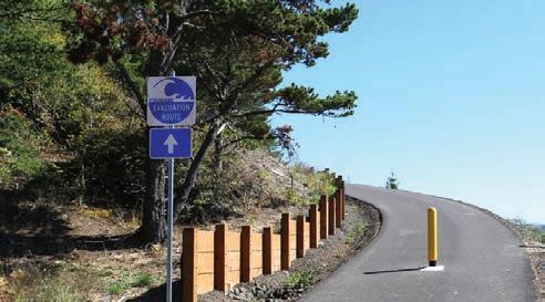
• Understand Oregon’s evacuation levels and know the evacuation routes in your area.
• Familiarize yourself with TripCheck.com.
• Make go bags with survival essentials for every member of your family, including pets.
Please remember to also look to your local leaders for additional tips on how your community is preparing. Connect with your local emergency management office, Community Emergency Response Teams (CERTs), sheriff’s office, or Tribal police and follow them on social media to stay up to date during quickly changing emergencies.
A pro tip: consider making copies of the im-

powered, not frightened, when thinking about how they will respond in an emergency.
I know this new Be 2 Weeks Ready Toolkit will help them build meaningful connections with one another that will lead to better outcomes for everyone when disaster strikes.
Chief
Chief
Reproduction
This new community-based initiative is designed to help individuals and their communities prepare for emergencies and practice their skills as a group. We encourage people to work through the Be 2 Weeks Ready Toolkit, and when possible, come together to practice their skills and share resources.
We want the Be 2 Weeks Ready program to foster a culture of preparedness within established groups such as
It’s important to note that being two weeks ready doesn’t have to be expensive or happen all at once. There are a lot of effective and low-cost to no-cost actions your community can take today to be ready for tomorrow. You can find more details about these on FEMA’s preparedness site Ready. gov, but I’ve included a few here:
• Visit ORAlert.gov to sign up or update your contact information to receive local emergency alerts.
• Enable Wireless Emergency Alerts (WEA)
portant documents you’ll need to get your life back on track after a disaster; scan or take photos of this information and store it in a password-protected online drive or on a flash drive in a waterproof container and keep it with your go bag.
In the end, what I most want for the people of Oregon is to feel em-
McMahon is the Oregon Department of Emergency Management (OEM) Director appointed in September 2023. She came to the agency as a retired U.S. Army brigadier general, attorney and combat veteran with 24 years of experience advising state and national leaders on emergent and active emergencies requiring operational and civilian support.
CHRIS BRANAM Guest Column
A transdisciplinary team of Oregon State University researchers, Extension specialists and students dedicated to helping coastal communities adapt to natural hazards has been recognized as one of four regional winners of the Outreach Scholarship W.K. Kellogg Foundation Engagement Award.
The Oregon Coastal Futures Project is one of four regional award winners announced today by the Association of Public and Land-grant Universities (APLU). The winners will compete for the C. Peter Magrath Community Engagement Scholarship Award, the top honor nationally for this type of initiative. The Magrath Award will be announced in November.
“As a modern, landgrant university, OSU partners with communities to solve of some of our state’s greatest challenges,” OSU President
members after a disaster.
Peter Ruggiero, a professor in the College of Earth, Ocean, and Atmospheric Sciences who leads Oregon Coastal Futures, said the project’s success started with working closely with a Community Advisory Council comprised of non-governmental organization representatives and agency personnel, who provided deep experience and expertise with coastal hazards impacts along the Oregon Coast.
said. “By engaging with the Advisory Council, local community-based organizations and community members themselves, our project was able to co-develop new knowledge about how underrepresented populations consider natural hazard risks, assess the protective actions they may take and explore new policy approaches that take these actions into account.”
Jayathi Murthy said. “The Oregon Coastal Futures Project is a shining example of how transdisciplinary research and teaching can combine with community engagement to benefit all Oregonians.”
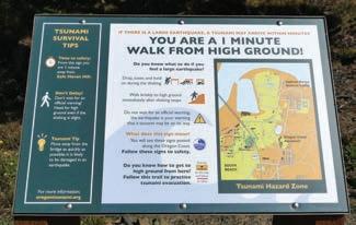
Oregon’s coastal counties are susceptible to sea level rise, coastal storms, and the rupture of the Cascadia Subduction Zone, which could lead to a massive earthquake and resulting tsunami. In response to a request from
Oregon’s coastal communities, OSU launched the Oregon Coastal Futures Project with community partners to improve the ability of underserved and rural residents to prepare for earthquakes, tsunamis, storms and rising sea levels.
The project uses a collaborative approach to consider social, economic and ecological costs and benefits of adaptation strategies. The project collects social, economic,

natural and infrastructure data to create nuanced equitable adaptation policies that examine how assets could best be protected and made accessible to community
“Our frequent meetings and conversations with the Community Advisory Council led to co-produced research approaches and priorities that broadened authentic connections with coastal communities,” Ruggiero
The university-community team of students, postdoctoral scholars, and community partners regularly share the broader impacts of their
Continued on Page 5


work, including more than 30 presentations to Oregon coastal lawmakers and public interest groups, at academic and professional conferences, and at “Science on Tap” talks. The team also has produced more than 15 peer-reviewed publications, two websites and multiple story maps.
Marina Denny, associate vice provost for engagement in the OSU Division of Extension and Engagement, said that OSU is committed to being an engaged university through its intentional and collaborative approach to reach and impact individuals and communities.
“We are the people’s university, committed to
engaging communities to mutually find solutions to big problems,” Denny said. “It’s inspiring that we have passionate faculty building strong and lasting relationships with community partners and contributing to significant environmental, social, and economic impacts on such a large scale. Engagement, when done well, is a transformational approach to strengthening university-community partnerships.”
In addition to Ruggiero, members of the Oregon Coastal Futures team are:
John Bolte, professor in the Department of Biological and Ecological Engineering in the College of Agricultural Sciences.
Patrick Corcoran, associate professor emeritus in the College of Earth, Oceans, and Atmospheric
Award. Open Campus, a program of OSU Extension that provides local access to learning to address the unique educational needs of Oregon’s communities, won in 2014.
The four regional winners — OSU, East Carolina University, the University of Minnesota and West Virginia University — will each receive a $5,000 prize to further their work.
Sciences (CEOAS), retired Oregon Sea Grant Extension coastal hazards specialist and a member of the project’s advisory council.
Daniel T. Cox, professor and director of the Cascadia Lifelines Project in the College of Engineering.
Steven J. Dundas, associate professor in the College of Agricultural Sciences and researcher
at the Coastal Oregon Marine Experiment Station.
Felicia Olmeta Schult, professor of practice in CEOAS and Oregon Sea Grant Extension coastal hazards specialist.
Jenna Tilt, assistant professor in CEOAS.
It’s the second time OSU has had a regional winner of the Outreach Scholarship W.K. Kellogg Foundation Engagement
Since 2007, APLU and the Engagement Scholarship Consortium, with support from the W.K. Kellogg Foundation, have partnered to honor the engagement scholarship and partnerships of fouryear public universities. The award recognizes programs that demonstrate how colleges and universities have redesigned their learning, discovery and engagement missions to deepen their partnerships and achieve broader impacts in their communities. The national award is named for C. Peter Magrath, APLU president from 1992 to 2005.
“Community engagement is a critical part of public universities’ mission and we’re pleased to highlight the work of institutions that are instrumental to solving the most pressing challenges facing their communities through partnerships with other stakeholders,” APLU President Mark Becker said.
Chris Branam is a news editor at Oregon State University’s University Relations and Marketing Department. Branam may be reached at 541-737-2940 or at chris.branam@oregonstate.edu


victims until they can be evacuated out of the area.
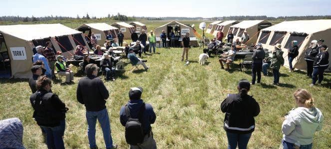
One of the larger efforts underway in the process of preparing a response to a natural disaster has been the creation of Evacua-

tion Assembly Points (EAPs). These are sites that would be used in
the early aftermath of a disaster to triage and temporarily care for

An EAP was established this year at the Newport Municipal Airport, and in May, a two-day exercise was held — the largest event of its kind ever on the Oregon coast. The training was coordinated by the Oregon Department of Human Services’ Office of Resilience and Emergency Management (OREM) in partnership with Lincoln County Emergency Management and a variety of other agencies. The purpose was to simulate an emergency, such as a Cascadia Subduction Zone earthquake and
ensuing tsunami, where first responders had an opportunity to set up, test, and demobilize tents and other EAP equipment.
Jeff Gilbert, OREM regional emergency coordinator, said during this exercise, “There’s a lot of folks that worked to bring this into reality, and those who are not familiar with an Evacuation Assembly Point, it’s a relatively new concept, but it’s one that we’re going to be putting a lot more time, energy and effort into. This is state, counties and cities
Continued on Page 7

Continued from Page 6
understanding of how we can become better prepared, not just for a Cascadia-type event, but large-scale wildfire or other issues that might impact citizens and we need to evacuate people off of the coast.”
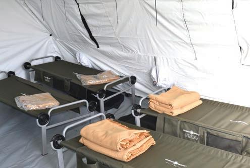
At the site were several tents that had been erected. They housed things like an incident command center, mess hall, medical center, registration area, dorms, and showers.
“A lot of folks are going to look at all of this tent structure and say that this is a shelter, but it’s not just a shelter,” Gilbert said. “This is an area where people are going to be brought to, triaged, (and) prioritized
to be removed from the coast into safe locations. So think of this as an assembly point to move people off of the coast.”
The EAP at the Newport Airport is capable of accommodating 80 people for up to two weeks before additional supplies will be needed. But the idea is that people will be continually evacuated and others brought in.
The mess hall will serve as more than just a place for people to eat. It will also be a place with activities for both young and old, and a place where people can gather to receive status updates.
The shower tent consist of six showers — two rows of three stalls. Each shower is curtained off for privacy, and showers will be scheduled.
A tank called a water buffalo can hold up to 500 gallons of water to supply the showers, and there is a propane heater to warm the water up.
The incident command center will house the operations team, mass care coordinator, communications and procurements and contract section.
Michelle Richards, mass care coordinator with OREM, said, “In an event, we’re going to be calling on our vendors and our partners within the communities. We want to make certain that this is always locally led — this is state supported, but local first. Those partnerships … really help us to be able to run this. We absolutely cannot do this without that support.

“We know that in a large-scale event, we’re not going to be able to get out here right away,” added Richards, “so that local presence is what’s really going to be driving this. So this (training exercise), to be able to set this up, gives us all the experience of what this looks like and helps local volunteers and partners be able to experience what this will feel like if they have to set this up on their own.”


Oregon Emergency Mangers already seeing significant reduction in time to communicate evacuation information.
Salem, Ore. - In honor of National Preparedness Month, the Oregon Department of Human Services (ODHS) is excited to announce a new contract that will provide advanced evacuation software to all of Oregon’s 36 counties and nine Tribes. The software, from Genasys Inc., will help manage emergency evacuations more effectively across the state.
As Oregon deals with more frequent and severe disasters, it’s essential to have a clear plan for evacuations and support services. While law enforcement handles the immediate evacuation of people, the ODHS Office of Resilience and Emergency Management (OREM) works with local communities to help identify people who need evacuation assistance and ensure people are evacuated to a location that meets their needs.
“Even well-prepared communities face challenges with evacuations, especially when multiple areas are affected. We’re thrilled to offer this new software to all our counties and Tribes,” said Ed Flick, Director of OREM. “This tool will help emergency managers make quick and informed decisions to keep everyone safe.
Over the last week the tool was used to coordinate evacuations for the Rail Ridge Fire in Grant, Crook and Wheeler Counties, which is Oregon’s top priority wildfire. National Preparedness Month is a great time for everyone to review their own emergency plans and supplies. For tips, check out Ready. gov.”
The Genasys EVAC software helps with planning and managing evacuations. It allows emergency services to quickly create and update evacuation plans, run realistic simulations, and respond faster during an emergency.
Nick Vora, Emergency Manager for Union County, shared his enthusiasm:
“Changing, exporting, and adding evacuation zones for alerts used to be slow and complicated. While there are many great mapping tools out there, they often made it timeconsuming to update evacuation zones and get them ready for emergency alerts. It could take 15 to 30 minutes to make these changes and load them into the alert system. With Genasys, however, the process is much faster. You can select and adjust an area and get it ready for alerts in just a few minutes. This quick turnaround makes managing emergency alerts much easier and more efficient.”
“Genasys Protect was instrumental in notifying community members of evacuations during the Falls and Telephone Fires in Harney County. When time is of the essence, being able to instantly notify community members of updated evacuation levels is crucial. We loved the ease of use and the ability to train new staff members on how to use it under one minute. This is an essential tool during wildfires,” said Melinda Todd, Harney County Emergency Manager.
Ken Kehmna, a retired fire chief and advisor at Genasys, added, “After Oregon’s severe fires in 2020, we tested this software in Deschutes and Jackson counties. Both counties saw great results and adopted the software, leading to its statewide use.”
Michael Smith, Senior Vice President at Genasys Protect, emphasized the benefits: “EVAC’s planning and real-time communication features are vital for managing emergencies in any community, from small towns to large cities.” This new software represents a significant step forward in making sure Oregon is ready for emergencies and can respond quickly and effectively.


Continued from Page 10
ODHS holds four distinct roles throu xgh its Office of Resilience and Emergency Management, all of which reduce the impact of disasters on people.
• Mass care: Planning for and supporting people in the early stage and immediate aftermath of emergencies. Our work includes things like coordinating evacuation assistance, the distribution of life-sustaining goods and services, including hydration, feeding, sheltering, reunification, and
distribution of emergency supplies.
• Social services recovery: Helping people and social services agencies recover. Our Social Services Recovery Coordinators work with survivors and their families to identify barriers to recovery, make a plan to address those barriers, and support the survivors on their journey. Our role also includes helping local social services agencies that may be impacted by the disasters to return to full functioning as soon as possible.
• Continuity of operations: Ensuring communities’ ongoing access to ODHS services. This includes making sure our offices are open and essential services continue, as well as supporting the agency programs and


the case managers who ensure the safety of the tens of thousands of Oregonians who may need extra and early help in an emergency.
• Legislatively directed resilience work: Warming, cooling and cleaner air shelters; water distribution and resilience hubs. These situations don’t fit what’s traditionally been considered emergencies, but they can have significant impacts on people. The Legislature made OREM the lead for this type of work to help people.
Across all these roles, ODHS develops and relies on partnerships and coordination with public and private organizations at the local and regional levels and with our state and Tribal Nation partners.
Astoria (503) 325-9906
Tillamook (503) 842-8755
Seaside (503) 738-4043
Lincoln City (541) 996-5102
Newport (541) 265-2888
Florence (541) 997-9495
(888) 271-8078 Toll Free www.NCHC.net
Did you know that floodwaters as little as six inches deep can be strong enough to sweep a person off their feet? Floods are among the most frequent and costly natural disasters. When heavy or steady rain saturates the ground over several hours or days, flood conditions may occur. Flash floods occur suddenly due to rapidly rising water along a stream or low-lying area.
Before
• Know your flood risk and locations where flooding may occur.
• Make an escape plan and build a kit.
• Listen to area radio and television stations and a NOAA weather radio for possible flood warnings and reports of flooding in progress or other critical information from the National Weather Service (NWS).
• Because standard homeowner’s insurance does not cover flooding, it’s important to have protection from floods associated with hurricanes, tropical storms, heavy rains and other conditions that impact the U.S. For more flood safety tips and
information on flood insurance, please visit the National Flood Insurance Program website at FloodSmart.gov.
• Raise your furnace, water heater and electric panel to floors that are less likely to be flooded. An undamaged water heater may be your best source of fresh water after a flood.
• Install checkvalves (valves that allow fluid to flow through in only one direction) in plumbing to prevent floodwater from backing up into the drains in your home.
• Seal walls in basements with waterproofing compounds to avoid seepage through cracks.
• If a flood is expected, some communities might offer free sandbags to residents. Listen to the news or contact local emergency management agencies to learn more about these resources.
• Fill your car’s gas
tank in case you need to evacuate.
• Move your furniture and valuables to higher floors of your home.
• Move livestock to higher ground. If using a trailer to evacuate animals, move animals sooner rather than later.
During
• When a flood or flash flood warning is issued for your area, head for higher ground and stay there. Avoid walking or driving through floodwaters. As little as six inches of moving water can knock you down, and two feet of moving water can sweep a vehicle away.
• Stay away from floodwaters. If you come upon a flowing stream and the water is above your ankles, stop, turn around and go another way.

Continued from Page 12
• If you encounter a flooded road while driving, turn around, don’t drown. If you are caught on a flooded road and waters are rising rapidly around you, get out of the car quickly, and move to higher ground.
• Avoid contact with floodwater. It may be contaminated with sewage or contain dangerous insects or animals.
• Dispose of any food that has come into contact with floodwater.
• Let friends and family know you’re safe.
• Do not enter your home until officials say it is safe to do so.
• Report downed power lines to your utility company and do not step in puddles or standing water.
• Wear protective clothing, including rubber gloves and rubber boots, and be cautious when cleaning up.
• Wear protective clothing, including rubber gloves and rubber boots, and be cautious when cleaning up.
• Disinfect anything that flood water touches.
More information about repairing your flooded home is available online at www. redcross.org.
Additional information, including maps about flooding, are available on the Oregon Department of Geology and Mineral Industries (oregongeology. org) or Washington Department of Natural Resources (dnr.wa.gov) websites.
Did you know that wildfires can move at speeds of up to 14 miles an hour?
Oregon and Washington are prone to deadly wildfires. Droughts and dry conditions throughout the year increase wildfire risk. Careless use of fire in highly wooded areas can also dramatically increase the chance of a wildfire, which can then quickly spread across trees and dry brush and threaten homes and businesses in the vicinity.
Before
• Learn about the wildfire risks in your area.
• Make an escape plan and build a kit.
• Clear leaves and other vegetative debris from roofs, gutters, porches and decks.
• Screen-in areas below patios and decks with wire mesh to prevent debris and combustible materials from accumulating.
• Remove flammable materials (wood piles, propane tanks, etc.) from within 30 feet of your home’s foundation and outbuildings, such as garages and sheds. If it can catch fire, don’t let it touch your house, deck or porch.
• Prune trees so the lowest branches are 6 to 10 feet from the ground.
• Identify and maintain an adequate water source outside your home, such as small pond, cistern, well or swimming pool.
• Gather household items that can be used as fire tools such as a rake, ax, saw, bucket and shovel.
• Keep a garden hose that is long enough to reach any area of the home and other structures on the property.
During
• Be ready to leave at a moment’s notice.
• Listen to local radio or television stations for the latest emergency information.
• Gather an emergency supply kit and be ready to leave.
• Arrange for temporary housing at a friend or relative’s home outside the threatened area.
• Confine pets to one room so you can find them if you need to evacuate quickly.
• Watch for and listen to air quality reports and health warnings about smoke.
• Keep indoor air clean by closing windows and doors to prevent outside smoke from getting in.
• Use the recycle or recirculate mode on the air conditioner in your home and/or car.
• Choose building materials and plants that resist fire.
• When smoke levels are high, do not use anything that burns or adds to indoor air pollution, such as candles, fireplaces and gas stoves. Avoid vacuuming.
• If you have asthma or another lung disease, follow your health care provider’s advice.
• Dress to protect yourself; wear cotton/ woolen clothing including long sleeved shirts, long pants and gloves.
• Back your car into your garage for easier evacuation.
• If you are trapped outdoors, crouch in a pond, river or pool.
• Do not place wet clothing or bandanas over your nose or mouth.
• Let friends and family know you’re safe.
• Do not re-enter your home until fire officials say it is safe to do so.
• Use caution when entering burned areas as hazards may still exist, including hot spots that can flare up without warning.
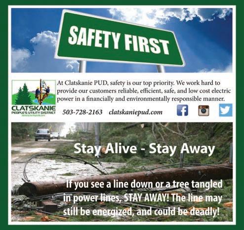
• Avoid damaged or fallen power lines, poles and downed wires.
• Wear leather gloves and heavy soled shoes to protect hands and feet.


Power outages are most commonly caused by bad weather, trees contacting electric lines or equipment, motor vehicle crashes affecting electric equipment, equipment failure or damage caused by animals. Faulty wiring and equipment in your buildings can also cause a localized power outage.
Investigate your home or business to determine if any electrical hazards are present. If there are, notify your local power company. If you see or smell any signs of an electrical flash or fire, call 911.
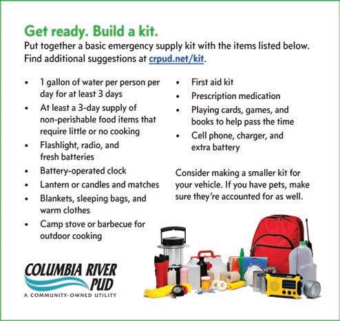
Look to see if your neighbors are also without power. Streetlights may be the best indication of this. Prepare in advance: assemble an emergency preparedness kit, with supplies such as water, non-perishable food, a flashlight, extra batteries, first aid kit and more; create a household evacuation plan that includes your pets; and stay informed abut your community’s risk and response plans.
Protect yourself during a power outage: keep freezers and refrigerators closed, only use generators outdoors and away from windows and understand
the risks of carbon monoxide poisoning, do not use a gas stove to heat your home, disconnect appliances and electronics to avoid damage from electrical surges, and check on neighbors, use flashlights instead of candles, eliminate unnecessary travel.
To keep your food from spoiling during a power outage, keep a cooler, ice and a digital thermometer on hand. Have at least a half tank of gas in your car and fill extra containers. If power is out for an extended time, gas supply may be limited.
Be safe after: throw away food that
has been exposed to temperatures 40 degrees or higher for two hours or more, or that has an unusual odor, color or texture; if the power is out for more than a day, discard any medication that should be refrigerated, unless the drug’s label says otherwise. If electrical power lines are down, do not touch them. Report downed lines to your utility company.
To report a power outage, call your local electric service.
Information was gathered from Tillamook PUD, Department of Homeland Security, and American Red Cross.