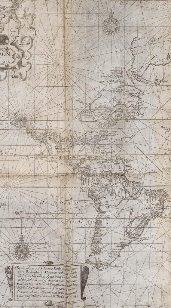
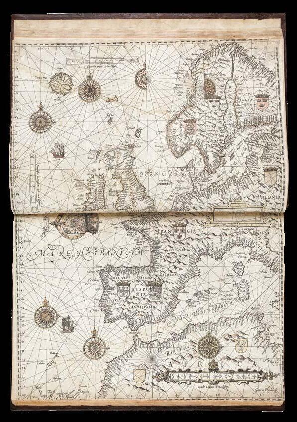
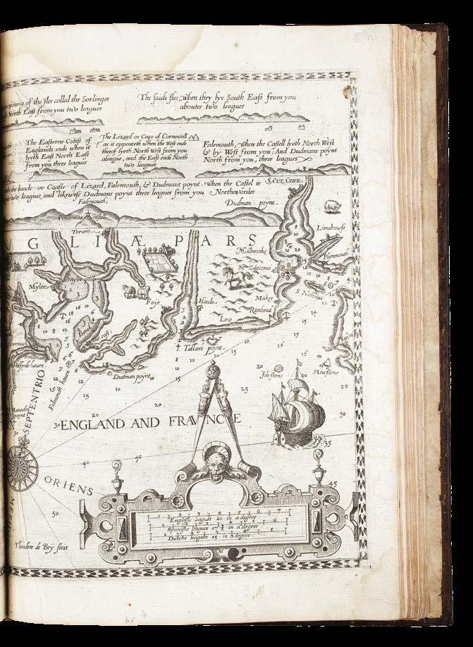
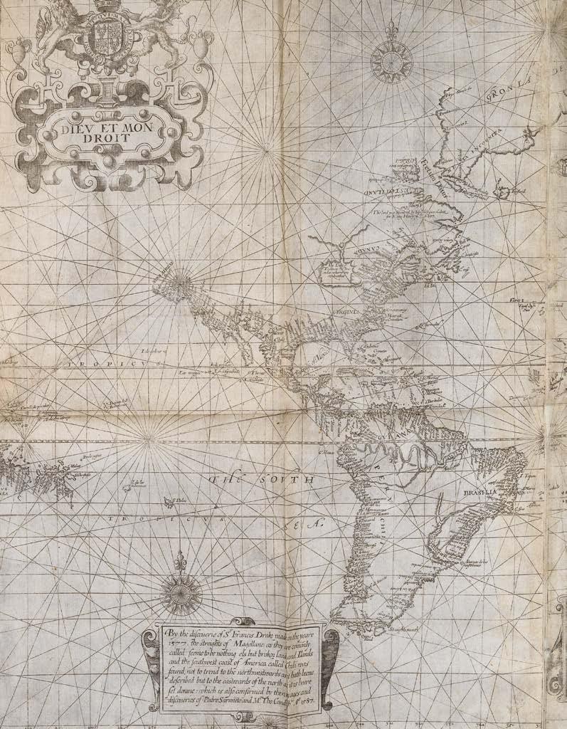
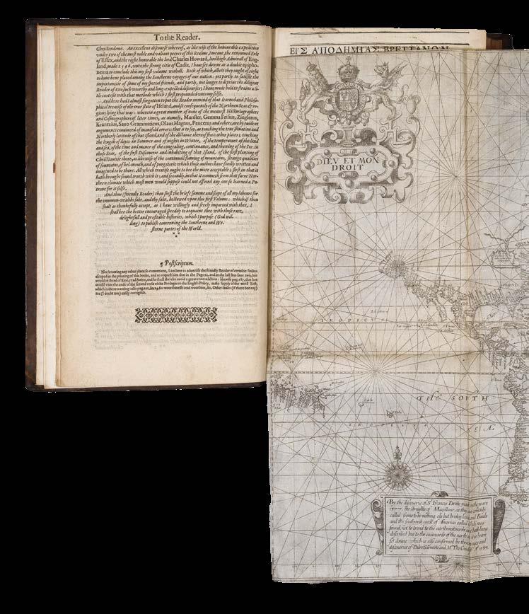
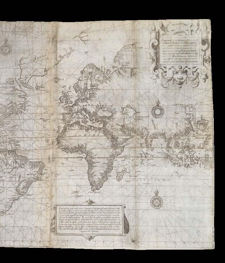
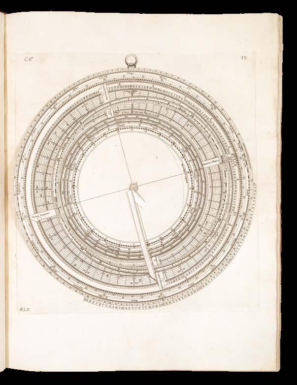
The Mariners Mirrour... Herein also may be understood the exploits lately atchived by the Right Honorable the L. Admiral of England with Her Ma[jes]ties Navie; and some former services don by the worthy Knight S[i]r Fran[cis] Drake.
Publication [London, J. Charlewood for ?H. Haslop, 1588].
Description
Two parts in one volume. Folio (391 by 266mm). Two engraved titles, engraved coat-of-arms of Sir Christopher Hatton, small engraved radial plate tipped in to A1, 3 engraved plates with volvelles, 45 double-page engraved charts, several charts with early hand-colour, some offsetting to a few charts; contemporary calf, gilt, spine in compartments, separated by raised bands, gilt.
References Koeman, Wag 13; ESTC, S122236; Hind, ‘Engraving in England’, 151–153; Koeman, ‘The history of … Spieghel der Zeevaerdt’, Lausanne, 1964; Skelton, ‘Bibliographical note’ in the facsimile edition, Amsterdam, 1966; Waters, ‘Art of navigation’, London, 1958; Waters, ‘Waghenaer’s … influence on English hydrography’ in ‘Lucas Jansz. Waghenser van Enckhuysen’, Enkhulzen, 1984.
$252,000
The first sea pilot printed in English
“In 1587 the English translation of Waghenaer’s ‘Speighel der Zeevaert’ was commissioned by the Lord Chancellor, Sir Christopher Hatton. The translation was carried out by Anthony Ashley, Clerk of the Privy Council, who used the 1586 Latin edition as a model. New plates were cut by De Bry, Jodocus Hondius, Augustine Ryther, and Johannes Rutlinger” (Koeman).
The maps are some of the earliest engraved in England and the atlas, as well as being the first printed sea atlas, was the first book to standardize symbols of buoys and beacons. The maps for the English edition were simplified from the earlier versions, removing the wavy lines chosen to represent the sea to make the rutter more useable onboard ship. The ornamental ships and sea monsters were retained, in part because the ships were useful to the mariner in determining location as the vessels depicted correspond to the stretches of coast shown. Such considerations do not, however, detract from the decorative appeal of the charts and the book “outranks any other rutter of its period, with its splendid presentation of charts and text; as such it stood as a model for the folio-sized charts and pilot guides with charts in the seventeenth century”(Koeman). Such was the popularity of this work in England that all subsequent sea atlases and pilots became commonly known as ‘waggoners’.
An exceptionally rare item. ESTC lists fifteen examples of the book, all in institutions; Koeman cites only eight. We are aware of one other complete example of this work coming up for sale in the last thirty years: the Wardington copy, sold for £90,000 plus premium in 2006. The present example was offered by John Howell Books in 1982, for $85,000.
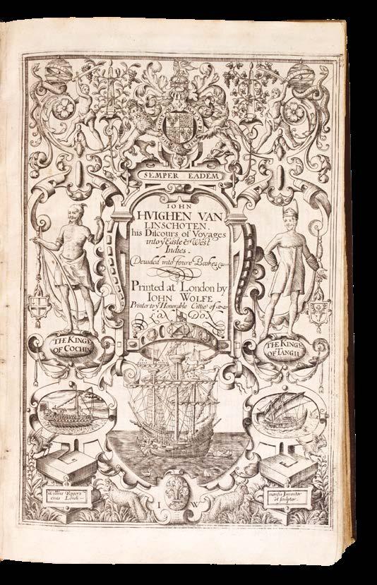
LINSCHOTEN, Jan Huygen van.
John Huighen van Linschoten his Discours of Voyages unto ye Easte & West Indies. Devided into Foure Bookes.
Publication
London, John Wolfe, 1598.
Description
Four parts in one volume. Folio (285 by 180mm). Mostly black letter, double column. [6] leaves, blank, engraved general title-page by William Rogers (Johnson, p.2, Rogers no.3), dedication, ‘To the Reader’, pages numbered 1-197 ‘The First Booke’, [1] leaf sectional vignette title-page with engraved map of the Congo, pages numbered [197]- 259 (ie 295) ‘The Second Booke’, [1] leaf sectional vignette title-page with engraved double- hemisphere map of the world, Shirley 182, pages numbered 307- 447 ‘The Thirde Booke’, [1] leaf sectional vignette title- page with engraved map of Spain, pages numbered [451]-462 ‘The Fourth Booke’; double-page engraved folding map of the world ‘Typus Orbis Terrarum’ (Shirley 169), 8 large doublepage folding maps, and 3 folding views of St. Helena and Ascension, 4 woodcut maps in text, woodcut initials, factotums and head-piece ornaments; full contemporary English calf, each cover ruled in blind with central gilt arabesque, the spine in seven compartments, citron morocco letteringpiece in one, the others decorated with a gilt ingot and pincer tool, upper hinge just starting at the head of the spine, endpapers renewed at early date.
Alden and Landis, 598:57; Borba de Moraes, I:417; Church, 321; ESTC, S111823; Hill, 182; Howgego, L131, G40; Luborsky and Ingram, 509; Parker, 159-161; Sabin, 41374; Schilder, 195228; Shirley [World], nos. 167 and 216; Shirley [Atlases], G.Lin 2a; Streeter Sale, 1:31; Worms, 1705; Worms and BayntonWilliams.
$323,000
“The navigator’s vade mecum for the Eastern seas” - one of the most influential English travel books of the sixteenth century
The very rare English edition of Linschoten’s ‘Itinerario’, first published in Dutch in 1595-1596, and translated from the Dutch by William Phillip.
Linschoten’s was the first printed work to include precise sailing instructions for the East Indies. Its exposition of a route to the south of Sumatra through the Sunda Strait allowed Dutch and, later, English merchants to circumvent the Portuguese stranglehold on passage, and, therefore, trade, to the East through the Straits of Malacca. This enabled the British East India Company and the Dutch East India Company to set sail for the Spice Islands and, ultimately, China and Japan, and was of such economic utility that, according to Church, and others, “it was given to each ship sailing from Holland to India” and soon became “the navigator’s vade mecum for the Eastern seas” (Penrose).
“This important work contains all the knowledge and learning related to the East and West Indies and navigations to those parts that was available at the end of the sixteenth century. It was held in such high esteem that for nearly a century a copy was given to each ship sailing to India as a guide to the sailing directions. The fact that most copies were in continual use is in no doubt the reason that fine copies, especially with all correct plates and maps, are so very rare” (Hill).
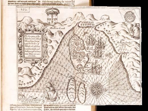
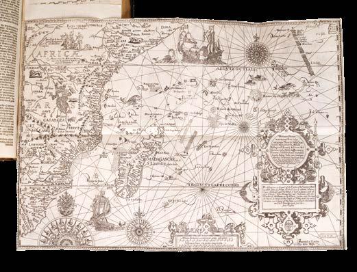
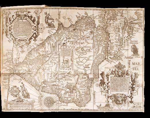
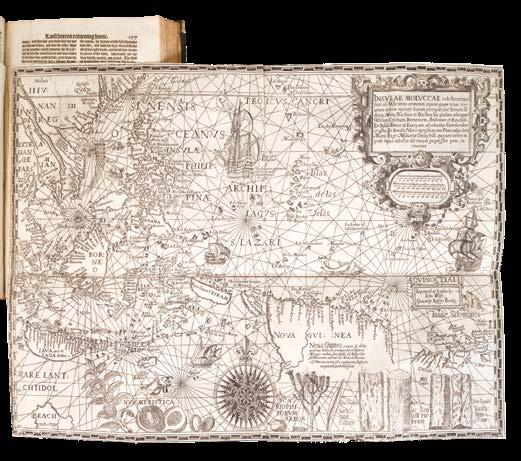
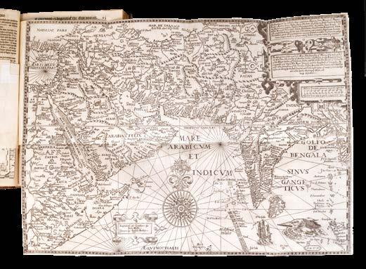
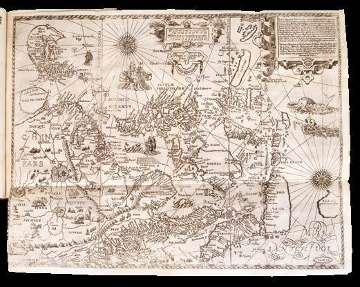
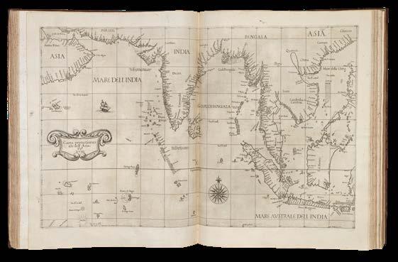
The work is made up of four parts. The first, provides the account of Linschoten’s travels in Asia and includes accounts of east coast of Africa, Arabia and as far east as Japan. The chapter is accompanied by fine folding maps of the world, Arabia and India, the southeast coast of Africa, a superb map of east Asia and the East Indies and finally one of southwest Africa.
The second book focuses on the west coast of Africa, around the Cape of Good Hope to Arabia and India. It also details the New World accompanying which is a fine map of South America extending northwards to Florida. The third book is derived from the discoveries of the Portuguese Royal pilot Diego Affonso, and details the navigation from Portugal to India, and onwards to the East Indies. Similar detail is also provided for Spanish America and Brazil. Accompanying this is the superb ‘Spice Islands’ map illustrated with spices of the region. The final fourth book provides economic details provided by the territories of the King of Spain.
In fact, until its publication, no other book contained anything like the amount of useful information on the East and West Indies, and it soon became required reading for all navigators sailing to the East, with chapters on the coast of ‘Arabia Felix’, i.e. the southern coast of the Arabian peninsula, the island of Ormus, and Islamic India.
“This is the first work outside of Portugal and Spain to provide detailed practical information on how to get to and engage in trade with America and India. The work was indispensable to sailors on the route to the Indies [and] served as a direct stimulus to the building of the vast English and Dutch overseas empires” (Streeter).
Jan Huyghen van Linschoten (1563-1611)
Linschoten was a native of Enkhuizen who travelled to Spain in 1576 to join his two elder brothers. The family moved to Lisbon during the troubles of 1581. Through family contacts the young Linschoten became attached to the retinue of Vincente de Fonseca as he was sent to Goa as Archbishop. Arriving in September 1583 he spent time travelling through Malabar and Coromandel. All the while he compiled a secret account of his findings. In 1586 Dirck Gerritsz (1544-1604) passed through Goa returning from Japan having also been to China. He was probably the first Dutchman to visit the former. He passed much of his knowledge to Linschoten.
The archbishop returned to Europe in 1587 to report to Philip II but Linschoten remained. Expecting his return, he later found out that he had died at sea. He resolved to return himself and through the auspices of Dutch traders such as the Fuggers and Welsers in India obtained the position of a factor on one of their returning vessels in 1589. He remained on the island of Terceira in the Azores for two years and made his way back to Holland in September 1592. He continued to gather further information from Dutch sailors even accompanied William Barentsz’s second voyage to the Kara Sea in 1594-95. In 1594 he received permission to publish his work. The ‘Itinerario’ was an instant success and combined his first-hand accounts with translations of Portuguese and Spanish documents.
Translation
Word of the significance of the book reached the publisher John Wolfe (fl.1579-1601) who records in the dedication:
“About a Twelvemonth agoe, a learned Gentleman brought unto mee the Voyages and Navigation of John Huyghen van Linschoten into the Indies written in the Dutche Tongue, which he wished might be translated into our Language, because hee thought it would be not onley delightfull, but also very commodious for our English Nation. Upon this commendation and opinion, I procured the Translation thereof accordingly, and so thought goo to publish the same in Print...’. That gentleman was identified in the address to the reader: ‘Which Booke being commended, by Richard Hackluyt, a man that laboureth greatly to advance our English Name and Nation”.
Wolfe was ideally placed to undertake the work, being “the first London bookseller to produce a sequence of map-illustrated works. He clearly kept a rolling-press and was possibly the first regular London book-printer to do so” (Worms & Baynton-Williams). The translation was undertaken by William Phillip. The maps and plates were engraved by Robert Beckit, Ronald Elstrack and William Rogers. Most are re-engravings of those in the Dutch edition. “Wolfe’s turbulent career, his clashes with his old master John Day and the Stationers’ Company, his imprisonments, secret presses, and faked imprints have sometimes obscured his other
achievements. He had an extensive international trade and was ‘the father of news publishing’ in London” (Worms).
“Financial help came from a group of London merchants who provided ten pounds to Hakluyt to see the book in print alongside a further thirty shillings towards the production of maps to accompany it” (Parker).
Illustration
The English edition did not include copies of the thirty or so illustrations of native peoples found in the Dutch edition.
List of maps
Most of the maps and views of the English edition are re-engravings of the plates of the original Dutch edition of 1595-1596, with captions in Latin and English.
1. [Anonymous after] ORTELIUS, Abraham, ‘Typus Orbis Terrarum’. An English derivative of Ortelius’ more up to date plate of 1587 and the earlier more decorative cloud border. Shirley (1993) 167.
2. [Mozambique], ‘The description of the Islandes and Castle of Mozambique...’, engraved by William Rogers.
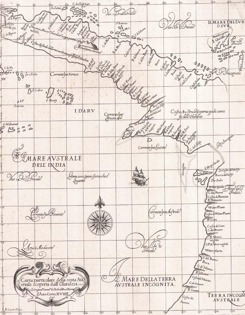
3. [Arabia, the Indian Ocean and India], ‘The description of the coast of Abex...’ A much-improved depiction of the Arabian Peninsula. Al-Qasimi (1999) p. 32 Dutch edition only; Ankary (2001) pp. 74-6, 148-9 referring only to the Dutch plate; Gole (1978) no. 8 listing only the Dutch plate; Schilder (2003) pp. 220-3; Tibbets (1978) no. 51: “The surprising fact about the representation of the [Arabian] peninsula is the close resemblance of the outline to that of a modern map when compared with other engraved maps of the time. There is a vague suggestion of the Qatar peninsula, which is not seen again until the nineteenth century” (Tibbets).
4. [East Africa], ‘The description or Caerd of the Coastes of the Countreys following called Terra do Natal...’, engraved by Robert Beckit, including the western half of the Indian Ocean along the coast of South Africa, all of Madagascar.
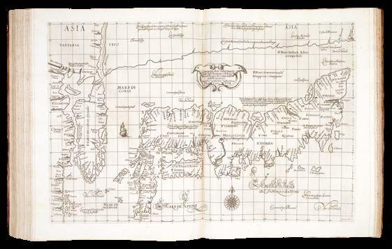
5. [Southeast Asia], ‘The Trew Description of All the Coasts of China...’, extending from the island of Korea and Japan south of ‘Beach’ (Australia), Java, Timor, the Philippines, the Indochina peninsula, and most of the coast and much of the interior of China), Chang (2003) pl. 16, p. 147 Dutch only, p. 192 no. 134 English; Geldart (2017) p. 19; Hubbard (2012) p. 47, fig. 36; Schilder (1976) no. 18 Dutch; Schilder (2003) pp. 222-6; Suarez (1999) pp. 178-9; Suarez (2004) p. 79; Walter (1994) no. 12 Dutch.
6. [St. Helena]
a. ‘The Island of St. Helena full of Sweet and pleasaunt ayre fructfull ground and fresh water...’,
b. ‘The true description, and situation of the Island St. Helena, on the East, North, and West Sydes’, both engraved by Raygnald Elstrak.
7. [Ascention Island], ‘The True Description of the Island of Ascention...’, engraved by William Rogers.
8. [Southwest Africa], ‘The description of the Coast of Guinea...’. Norwich (1983) no. 239a Dutch; Schilder (2003) pp. 215-19; Tooley (1969) p. 67 Dutch.
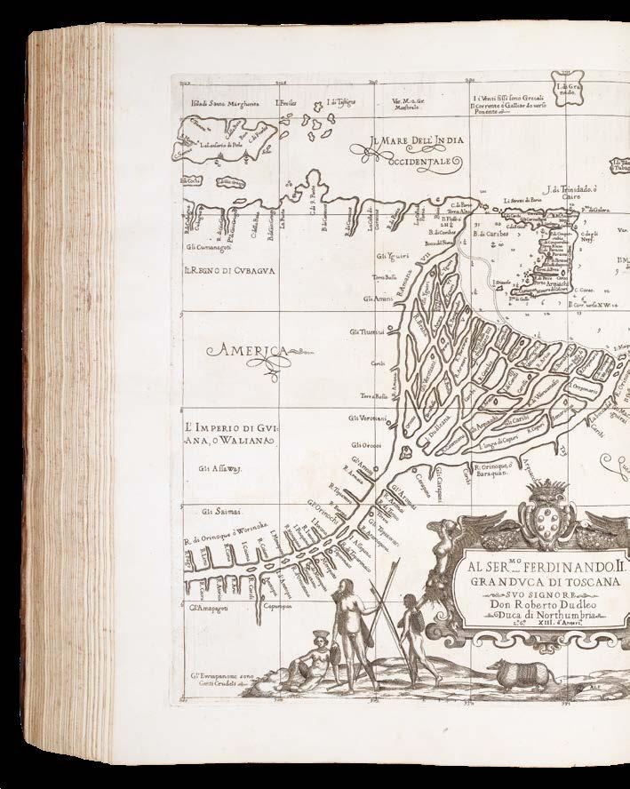
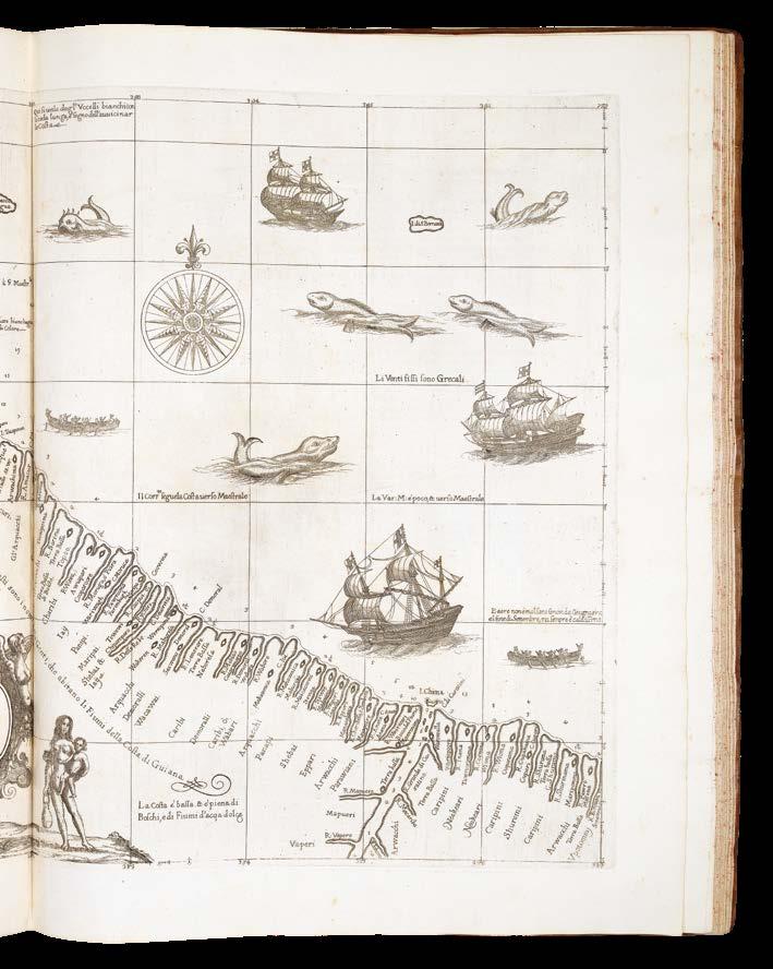
9. [South America], ‘The description of the whole coast lying in the South Seas of Americae called Peru...’, displays the whole of South America, Caribbean and Florida. Schilder (2003) pp. 226-8.
10. [The Spice Islands Map], ‘Insulae Molucca celeberrimae...’, extends from southeast Asia to the Solomon Islands and northwards to include the Philippines. The famous Spice Island map, so called for its depiction of the spices nutmeg, clove, and sandalwood along the bottom after the original by Petrus Plancius who obtained his information covertly from the Portuguese maps of Bartolomeu Lasso. Schilder (2003) pp. 117-22; Suarez (1999) pp. 177-9.
Provenance
1. Large seventeenth century engraved armorial bookplate with motto in Latin and English: “Ostendo non ostento” - “In things transitory resteth no glory”, the Isham family, of Lamport Hall, probably Sir John Isham (1582-1651), 1st Baronet of Lamport, advanced by Charles I on the 30th May 1627. A scion of the family, Captain Henry Isham (c.1628-1675) emigrated to America in 1656, where he settled in Henrico County, Virginia, and became the ancestor of, amongst others, President Thomas Jefferson; 2. With Bernard Quaritch, 1924.
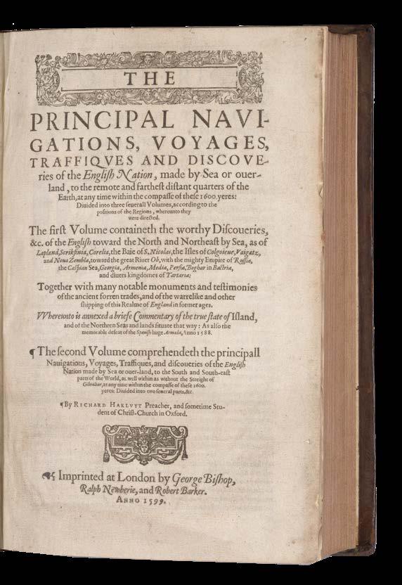
HAKLUYT, Richard, and WRIGHT, Edward
The Principal Navigations, Voyages, Traffiques and Discoveries of the English Nation, Made by Sea or Over-land...
Publication
London, George Bishop, Ralph Newberies and Robert Barker, 1599–1600.
Description
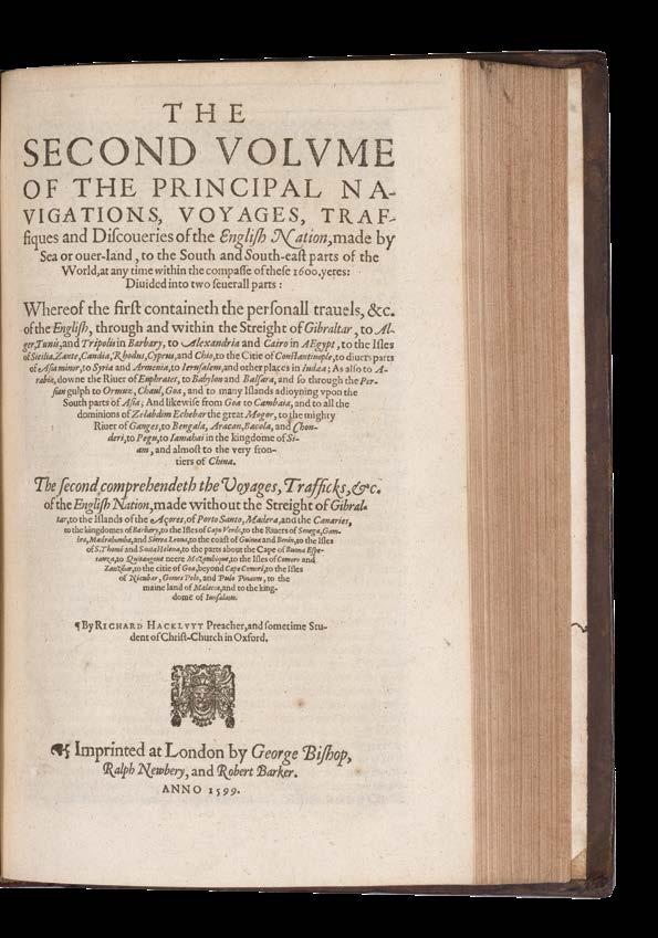
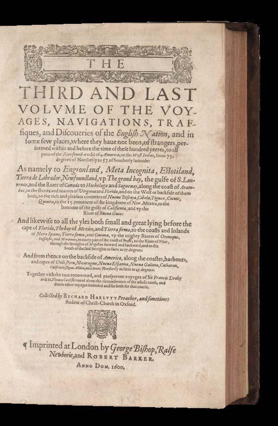
3 works bound in 2 volumes, folio (286 by 181 mm), complete with the rare WrightMolyneux world map on two sheets joined, map carefully trimmed to the neatline, with repaired closed tear and light restoration around folds, eighteenth-century bookplate of John Seale of Mount Boon, Devon, to front pastedown of second volume, vol. I sig. I6 with chip to fore edge just grazing shoulder note, a few leaves in same volume with very minor peripheral damp staining; vol. III sig. I5 with text misaligned with consequent slight shaving of shoulder note, contents generally very clean and fresh, mid-eighteenth century calf, recent red morocco labels to style, neat restoration at extremities, covers panelled in blind, light red speckled edges.
Dimensions
Map dimensions: 630 by 430mm. (24.75 by 17 inches).
References
Borba De Moraes, pp. 391–92; Church 322; ESTC S106753; Grolier English 100, 14; Hill 743; JCB (3) I:360–61; LOC European Americana 598/42; Penrose, Boies, ‘Travel and Discovery in the Renaissance 1420–1620’, p. 318; Pforzheimer 443; Printing and the Mind of Man 105; Quinn, p. 490; Sabin 29595-97-98; STC 12626; cf. Shirley 221.
$1,000,000
“The great prose epic of the Elizabethan period” with both the Wright-Molyneux world map and the rare suppressed ‘Voyage to Cadiz’
The Wright-Molyneux Map is the first English map on Mercator’s projection, it is the first map to name Lake Ontario, and one of the first maps to use the name “Virginia”. Richard Hakluyt’s ‘Principall Navigations’ is first collection of English voyages, published at the height of Elizabethan maritime prestige and “the great prose epic of the Elizabethan period”.
The Wright-Molyneux Map
Gerard Mercator (1512-1594) revolutionized cartography with his development of an isogonic cylindrical projection that mapped a sphere on to a flat plane. Mercator expected that his projection would be a valuable tool for navigators but he neglected to provide practical guidelines on how use it. Edward Wright (c1558-1615), a professor of mathematics at Cambridge University, modified Mercator’s system and published his results, ‘The Correction of Certain Errors in Navigation’, in 1599 and again in an improved edition entitled ‘Certaine errors in navigation, detected and corrected’ (London, 1610). Wright’s book contained new mathematical tables and instructions on plotting straight-line courses on maps based on the Mercator projection. The system developed by Wright contributed to the supremacy of the British Navy and is still in use today.
Wright published ‘A Chart of the World on Mercator’s Projection’ in 1599 based on his projection of a globe engraved by the English globe maker Emeric Molyneux in 1592. It was the first map to use Wright’s improvements on Mercator’s projection. It quickly became famous, even catching Shakespeare’s attention: in “Twelfth Night”, first performed in 1602, Maria says of Malvolio: “He does smile his face into more lines than is in the new map with the augmentation of the Indies” (Act III, Scene II). Unlike many maps and charts of the era that represented the often fantastic speculations of their makers, Wright’s ‘Chart of the World’ offers a minimum of detail and even leaves areas blank wherever geographic information was lacking. These undefined areas are especially evident along Wright’s coastlines. For example, the coast of California above Cape Mendocino is blank.
Wright’s world map depicts a wider Pacific Ocean than other maps of its time. On the American continent, Wright labels upper California ‘Nova Albion’; other maps designated this area ‘Anian’ but Wright adopted the name given the region by Sir Francis Drake. ‘Quivira’ still appears on the West coast. Further to the east, the map also shows a ‘Lake of Tadouac’ reminiscent of the Sea of Verrazano. This lake is connected to the Atlantic Ocean by a river that appears to run south of the St. Lawrence River. It is also connected to a large body of water to the north. Lake Tadouac is apparently an early reference to either the Hudson Bay or to the Great Lakes, neither of which were “discovered” by Europeans until eleven or twelve years after Wright’s map was published. Wright’s map is also one of the earliest maps to use the name “Virginia”.
The present example is in the second state, also from 1599, with the cartouche with engraved text describing Drake’s discoveries in the Americas added to the lower left of the map.
Top left are the arms of Elizabeth I; top right a strapwork cartouche with a text about Francis Gaulle’s discoveries in the Pacific; and bottom centre another cartouche with a general description of the chart.
The Principall Navigations
Comprising 243 narratives of voyages and travels in the New World in some 1,700,000 words, ‘The Principall Navigations’ is the greatest assemblage of travel accounts and navigations to all parts of the world collected up to its time, and a vital source for early New World exploration. “It is difficult to over rate the importance and value of this extraordinary collection of voyages” (Sabin).
This second edition of Hakluyt’s voyages is, in fact, an entirely different book from the initial 1589 compilation and was greatly expanded from the single-volume original. Boies Penrose considered that “the first edition of the Principal Navigations transcended anything that had gone before, though it, in turn, was surpassed by the second edition”. Indeed, Hakluyt devoted his life to the work and “throughout the 1590s, therefore, this indefatigable editor set himself to the formidable task of expanding the collection and bringing it up to date … this was indeed Hakluyt’s monumental masterpiece, and the great prose epic of the Elizabethan period … Much that was new and important was included: the travels of Newbery and Fitch, Lancaster’s first voyage, the new achievements in the Spanish Main, and particularly Raleigh’s tropical adventures …The book must always remain a great work of history, and a great sourcebook of geography, while the accounts themselves constitute a body of narrative literature which is of the highest value in understanding the spirit and the tendencies of the Tudor age” (Penrose).
Hakluyt’s Principal Navigations was one of the major prestige publications of the Tudor state, seeking to do for English exploration what Holinshed’s Chronicles had done for the nation’s history, a key work in promoting overseas ventures. Hakluyt himself never travelled further afield than France, but he met or corresponded with many of the great explorers, navigators, and cartographers including Drake, Raleigh, Gilbert, Frobisher, Ortelius, and Mercator. In addition to long and significant descriptions of the Americas in volume 3, the work also contains accounts of Russia, Scandinavia, the Mediterranean, Turkey, Middle East, Persia, India, south-east Asia, and Africa. Hakluyt owed a good deal to Sir Francis Walsingham’s support and probably gathered intelligence for him in Paris; the first edition was both dedicated to and licensed for publication by him. After Walsingham’s death in 1590, the patronage of Sir Robert Cecil was increasingly important to Hakluyt. Volume I of the second
edition of the Principal Navigations was dedicated to the lord admiral, Lord Howard of Effingham, but the other two were dedicated to Cecil.
Here the first volume contains the original printing of the rare ‘Voyage to Cadiz’, which was suppressed by order of Queen Elizabeth after Robert Devereux, the Earl of Essex, incurred her wrath by returning to England from Ireland without leave in 1599 to marry Sir Philip Sidney’s widow, the daughter of Sir Francis Walsingham. This copy is the second issue of the second edition with volume I dated 1599. The first issue is dated 1598, and its title page makes reference to the Earl of Essex’s voyage to Cadiz, which was ordered to be suppressed because Elizabeth was angered by Essex’s status as a popular hero of the war against Spain. However, the printed leaves detailing the voyage to Cadiz, pp. 607-619, which ought also to have been suppressed, are here present in their original uncancelled state.
The third volume is devoted almost entirely to the Americas, the South Seas, and various circumnavigations of the world. It includes the accounts of Niza, Coronado, Ruiz, and Espejo relating to New Mexico; Ulloa, Drake, and others concerning California; and Raleigh’s account of Guiana. “Hakluyt was a vigorous propagandist and empire-builder; his purpose was to further British expansion overseas. He saw Britain’s greatest opportunity in the colonization of America, which he advocated chiefly for economic reasons, but also to spread Protestantism, and to oust Spain” (Hill).
Edward Wright’s world map was, according to Quinn’s 1974 census for ‘The Hakluyt Handbook’, only to be found in 19, of the 240, predominantly institutional, examples of the book surveyed. Quinn notes that this survival rate is, even allowing for the high mortality levels traditionally attached to decorative world maps in books, “sufficiently low to raise the possibility that not all copies were equipped with the map, either because it was made available after many sets had been sold, which would mean that its date might be later than 1599, or because it was an optional extra supplied at additional cost”. Quinn’s survey included all major booksellers’ catalogues and public auctions in the English speaking world.
Subsequent to this 1974 census, the only other copy we know to have appeared in commerce with the map in the past half-century is the Grenville–Crawford–Rosebery copy, bound in early nineteenth-century red morocco, which lacked the map until a supplied copy was inserted sometime between its sale at auction by Sotheby’s in 1933 and its reappearance in the Franklin Brooke-Hitching sale, Sotheby’s, 30 Sept. 2014, lot 579. Hakluyt’s use of this map in his publication was to show “so much of the world as hath beene hetherto discovered, and is comme to our knowledge”.
The historical importance of the work cannot be overstated. It is truly “an invaluable treasure of nautical information which has affixed to Hakluyt’s name a brilliancy of reputation which time can never efface or obscure” (Church). ‘The Principall Navigations’ “redounds as much to the glory of the English nation as any book that ever was published” (Bancroft).
Rarity
Known examples of the Wright-Molyneux map British Library, London (3 copies); Bodleian Library, Oxford; Chatsworth House, Derbyshire; Eton College Library, Windsor; Huntington, San Marino (2 copies); Newberry Library, Chicago; Lilly Library Bloomington; Clements Library, Ann Arbor; Princeton (2 copies); New York Public Library, New York; Philadelphia Public Library, Philadelphia; Naval War College, Newport; JCB Library, Providence; University of Virginia, Charlottesville; Mitchell Library, Sydney.
Provenance
Sir John Henry Seale, 1st Baronet (1780–1844) of Mount Boone in the parish of Townstal near Dartmouth in Devon, was a Whig Member of Parliament for Dartmouth in 1838. He was created a baronet on 31 July 1838. He owned substantial lands in Devon, mainly at Townstal and Mount Boone. Together with the Earl of Morley of Saltram House near Plymouth, he built several bridges in Dartmouth, most notably the Dart crossing.
Blaeu’s pilot of the Mediterranean
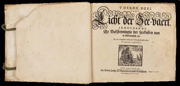
BLAEU, Willem
‘T Derde deel van ‘t Licht der zee-vaert, inhoudende de beschryvinghe der zeecusten van de Middelandtsche Zee, By een vergaedert ende in’t licht ghebracht door Willem Janssen. Blaeu.
Publication Amsterdam, W. J. Blaeu, 1618.
Description
Oblong quarto, (270 by 300mm), 33 charts numbered 1-30, 2 unnumbered charts and one in the text, a few worm holes to upper left, affecting first 13 leaves, and first chart, a few charts trimmed to neatline, a few age toned; contemporary Dutch vellum, with original ties.
References Koeman M. Bl 8.
$207,000
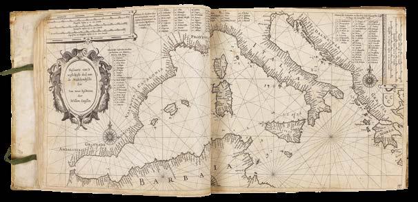
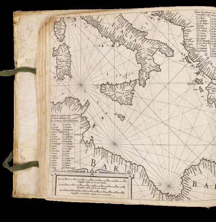
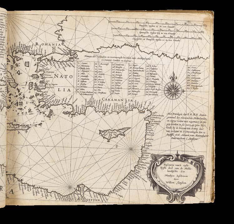
The extremely rare third part of Blaeu’s ‘Licht der Zeevaert’, covering the Mediterranean Sea.
Blaeu published the first two books of the ‘Licht der Zeevaert’, covering the Western, and Eastern and Northern navigations (i.e. the coast from Amsterdam to the Straits of Gibraltar; and from Amsterdam to the Scandinavia), in 1608. In 1618, he issued a third book covering the Mediterranean; the first pilot of those waters to be published since Barentsz’s ‘Nieuwe Beschryvinghe ende Caertboeck van de Midlandtsche’, last published in 1609. In the works dedication, Blaeu pays handsome tribute to Barentsz’s pilot, and although he has taken a great deal of information from the earlier work, Blaeu easily surpasses it in detail and accuracy.
The pilot consists of 33 finely engraved charts, the first two are general chart of the Western and Eastern Mediterranean, respectively; with the subsequent charts plot a clockwise course of the coast, beginning and ending with the Straits of Gibraltar. For a full description of the ‘Licht der Zeevaert’, please see item 23.
Blaeu would publish further editions of the pilot in 1621, and 1623. All editions are extremely rare. We are unaware of another example appearing at auction since the Second World War.
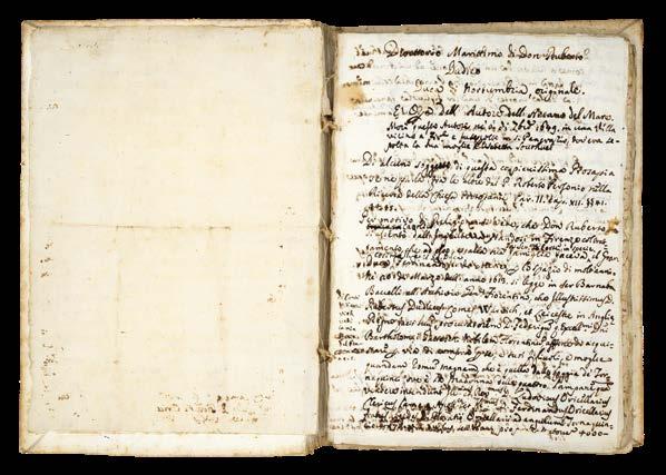
DUDLEY, Robert; and others
Direttorio Marittimo di Don Roberto Dudleo Duca di Northumbria fatto p[er] ordine del Ser[issimo]Gr: Duca di Toscana suo Sig[no]re e diviso in due Tomi et ogni Tomo in due libri co[n] suoi Capitoli.
Publication [Firenze, c1637-1647].
Description Folio (290 by 196mm). Original working autograph and holograph manuscript, in Italian, illustrated throughout with diagrams, and drawings of instruments, on seventeenth-century Italian paper, with various watermarks including a Sun (similar to Heawood 3893) and a Medici Coat-ofArms (similar to Heawood 786), extensively revised at the time, some pages edited with paste-overs, others excised; early drab Italian stiff paper wrappers, stabbed and sewn as issued.
Collation: 282 pages, foliated in pencil; pages [i-iv] bio-bibliography by Domenico Maria Manni; 1: title-page; 2: additional draft title-page, and dedication; p3-14: prospectus of contents (cancelled), followed by autobiographical ‘Proemio’; p15-139: ‘Direttorio Marittimo’, revised texts of 28 chapters of ‘Dell’arcano del mare’, incorporating theological ‘Proemio’, pp39-40; p140-146 addenda.
Condition: a few leaves missing between folios 86 and 87 (chapter xix and the beginning of xx), some lower margins trimmed, occasionally crossing the text
References
R. Dudley, Dell’Arcano del mare, 6 books in 3 volumes, Florence, 1646-1647; Dell’arcano del mare, second edition, Florence, 1661; Arthur Gould Lee, The Son of Leicester, the Story of Sir Robert Dudley, London, 1964; J. T. Leader, Life of Sir Robert Dudley, Florence, Barbera, 1895; J. F. Schutte, S. J., ‘Japanese Cartography at the court of Florence; Robert Dudley’s maps of Japan, 1606-1636’, in Imago Mundi (23), 1969, pages 29-58; Giovanni Targioni-Tozzetti, Notizie degli aggrandimenti delle scienze fisiche accaduti in Toscana nel corso di anni LX. del secolo XVII, 3 volumes. Florence, 1780; Manoscritti e alcuni libri a stampa singolari esposti e annotati da Pietro Bigazzi. Firenze, Tipografia Barbera, 1869.
$645,000
Dudley’s original manuscript manual for the use and instruction of the officers of the Tuscan fleet
The only known manuscript example of any part of Robert Dudley’s magnum opus, ‘Dell’arcano del mare’ held in private hands. An astonishing survival: a working manuscript, seemingly specifically assembled for the eyes and instruction of the officers of the Tuscan Navy, the Knights of St. Stefano, rather than for a public audience. This suggestion is borne out by the wording of the first title for the work that Dudley has crossed out (page 2): ‘Compendio del Direttorio Marittimo: Il pr[im]o Tomo e intilato, Supplemento della Navigare. Nel pr[im]o libro si discorre dell ‘arte, piu Curiosa di Navigare...’.
This was also the theory of Sir John Temple Leader, previous owner, and Dudley scholar: “It seems probable that the Arcano del Mare was only a resume of several previous works by Dudley. One of them is the MS. volume, quarto size, of which I possess the original, mostly in Dudley’s own hand. It is called the ‘Direttorio Marittimo’, and was written in very faulty Italian for the use and instruction of the officers of the Tuscan fleet. In it most of the subjects enlarged upon in the Arcano, are treated concisely, including great circle sailing and all kinds of navigation ; the administrative management of a fleet, and its manoeuvres in a naval battle, etc. The book is in ancient covers of thick paper, and preceded by a dedication to the Grand-Duke, and by a sketch of Dudley’s own naval life, written in his own hand with all his corrections and underlinings” (Leader, page 19).
Leader acquired the ‘Direttorio’ from Florentine librarian, collector, and bookseller, Pietro Bigazzi, from who he also acquired Gian Carlo de’ Medici’s (1611-1663), first edition of ‘Dell’Arcano del mare’, and a second edition, too. Leader writes about all three works, and the story of their acquisition, in his ‘Life of Sir Robert Dudley’ (1895).
The texts of the ‘Direttorio’ have clearly been written by Dudley, over time, but from at least as early as 1643-1644, and are further annotated by him up until 1647 (he died in 1649), and then further annotated by others, up until the publication of the second edition of 1661. They include: Dudley’s autobiography, in which he sets out his credentials as an expert in all things maritime - exploration, navigation, naval warfare, and architecture; several drafts and a completed version of a theological preface, or ‘Proemio’, which was eventually published in the second edition of the ‘Dell’arcarno del mar’ (1661); 28 chapters of material related to the text of the first edition of the ‘Dell’arcano del mare’ (1646-1647); theoretical navigational material not published in either edition of the ‘Dell’arcano del mare’.
Contents
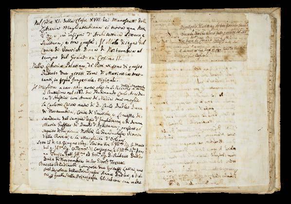
Pages [i-iv]: later bio-bibliography
Written by Domenico Maria Manni (1690-1788) director of the Bibilioteca Strozzi, polymath, editor and publisher, also a member of Academia dell Crusca. He owned the ‘Direttorio’, according to Giovanni
Targioni -Tozzetti (1712-1783), see ‘Notizie degli aggrandimenti delle scienze fisciche: accaduti in Toscana nel corso dianni LX del scolo XVII Florence’, 1780, volume I., page 80. These notes include mention of the manuscript design by Dudley of the Mole at Livorno in the time of Cosimo II (1590-1620) which was then in the Magliabechiana library. Manni also notes two imperial folio volumes, in the Palatina di Pitti library, of “Marine Treatises”, i.e. Dudley’s manuscript Treatise on marine architecture, began before 1610, in English and continued in Italian, by Dudley, until about 1635 (see Maria Enrica Vadala, ‘Il Trattato dell’architettura maritima di Roberto Dudley, storia e dispersione di un manoscritto’, Studi secenteschi, vol. 61 (2020), pages 193-237).
Manni writes: “Leaving aside many superfine circumstances which have given the Author the opportunity of attending to the theory and practice of the art of navigation, it will suffice to say that as a young man he had a natural sympathy for the sea, so that although he had a very pleasant charge on land in 1588 under his father, then Generalissimo, he nevertheless wanted to exercise the maritime militia, on which the greatness and reputation of the Kingdom of England then depended. Desirous still of discovering new countries (which pert made to manufacture and arm vessels of war), Author confided much in the great knowledge and experience of the famous seafarer and learned mathematician Abram Kendal of England, his master. Hence it followed that in 1594 he began his voyage to West India to discover and open the passage of the Guyana or Walliana Empire in America, and at that time he was much nominated as a great and rich nation; as he did with good success being General by sea and land with his vessels and people etc.”
Pages 1-2: Title-pages and Dedication
Dudley opens his ‘Dorettorio’ with a heart-felt dedication, officially to Grand Duke Ferdinand II, as was proper, and as he did ‘Dell’arcano del mare’. However, in this instance, he goes to great pains to go above and beyond that dedication to extend his tribute to the “Generalissimo del Mare”, i.e. Gian Carlo de’ Medici (1611-1663), Cardinal from 1644, “High Admiral of the Tuscan Navy”, “General of the Mediterranean Sea”, and “General of the Spanish Seas”. Gian Carlo was the second son of Cosimo II de’Medici, Grand Duke of Tuscany, and Maria Maddelena of Austria, and the recipient of a superb example of ‘Dell’arcano del mare’, with which the current manuscript was previously housed.
Humbly, Dudley hopes that “in [the ‘Direttorio] one can find something not useless for the common good of Navigation for your Highness and for Prince Giovanni Carlo Medici”. And thanks the Medici family for their support during the “past 37 years that he has been in voluntary exile …and under their protection”, dating the dedication to 1643-44.
Dudley then notes that he took the trouble to finish the ‘Direttorio’ in the best way that his experience in 50 years of maritime affairs (i.e. since 1594) has been able to produce and plan, but if he has erred in anything he hopes he will be excused.
Pages 3-14: ‘Supplem[en]to della Navigaz[io]ne perfetta Tomo primo libro I : proemio’
Dudley writes of his many maritime achievements in exploration, warfare, and naval architecture, clearly intending to give authority to the following texts: “Setting aside many superfluous circumstances which have occasioned the author to turn his attention to the theory and practice of the art of navigation, suffice it to say that he is Nephew of three Grand Admirals of England (or Generalissimi of the Sea, which is one of the highest offices held under that of the Crown) and that he had from his youth a natural sympathy for the sea, and this in spite of his having in 1588 held the very honorable post of Colonel in the land forces, which he exercised under the command of his father, the General in Chief and Grand Master of England…”
As Tyacke reports: this ‘proemio’ or autobiographical preface is not printed in the first edition of the ‘Dell’Arcano del mare’; nor is it the “theological proemio” which is printed in the second edition of 1661; but rather an account of Dudley’s career before he arrived in Florence. It is clearly designed to establish his credentials and to add great authority to the ‘Direttorio’. The text describes how Dudley had learnt the art of navigation and maritime discipline at about the age of 17, had experience of battle under his father the Earl of Leicester, and of navigation, and of designing warships and of participating in sea battles. There is a version of the text he wrote for Richard Hakluyt’s ‘Voyages…’ (1600) (volume III page 574) about his voyage to Trinidad and to the Orinoco, and Guiana in 1594 (see George F. Warner, ‘The voyage of Sir Robert Dudley …to the West Indies’, (1594-1595), Hakluyt Society, 1899).
In this autobiographical preface Dudley writes: “Si contento, non di meno, che consumasse il capricio e la spesa dall India Occidentale, p[er] scoprire et aprire il passo dell Imperio di Guiana o Walliana in America molto nominato in quel tempo pazione grande e vicca si come fece essendo Generale per mare...si fece padrone dell Isola della Trinita scopri la Guiana” – “He was happy, nevertheless… to discover the West Indies and open the way to the Empire of Guiana or Walliana in America, much known at that time as a great and wealthy country, and to be the General for the sea voyage … he made himself master of Trinita Island [Trinidad]; He discovered Guiana”. Dudley always claimed that he got to the river Orinoco in Guiana, in 1594 before Sir Walter Ralegh.
Dudley then writes about the famous learned mariner and mathematician Abraham Kendal who was his ship’s master on his voyage to Trinidad,
and then records how he had sent Captain Wood on a voyage to China (which in the event was unsuccessful). He records his own participation in the raid on Cadiz to destroy the Spanish fleet being assembled in 1596; he says in this and other voyages he practised navigation and the maritime and military disciplines, using great circle sailing and longitude: ‘di gra circoli e della longitude’, adding the words “come Arcano” – “as in the Arcano”, presumably a bit later.
He says that mariners have not well understood, nor practiced, navigation, according to great circles, and the other “spiral and horizontal methods”, with practical longitude.
It is his intention to explain how to do this, and a later insertion, by Dudley, in the margin, says that the first book teaches the method of using the hydrographical and general charts of the Author.
Pages 15-139: ‘Direttorio Marittimo’, revised texts of 28 chapters of ‘Dell’arcano del mare’, incorporating theological ‘Proemio’ (pages 39-40)
This is a theological preface to the ‘Direttorio’, and Dudley assures the censors that these potentially troublesome mathematical matters were in fact created by God himself along with natural and supernatural elements. Dudley formulates his argument for scientific knowledge, of which there are three types: the natural, supernatural, and the efficacy of the scientific (i.e. geometry and mathematics, see page 39) “le cose mathematiche sono certe, sicure et infallibili p[er] dimonstrazione e pero sono pui excellenti delle cose naturali...ma sono inferiori, delle cose supernaturali et immutabili”. An earlier version, on page 15, has crossed out “intelletto humana non arriua” – “Mathematical things are as certain and infallible by demonstration and therefore they are superior to the natural senses …but they are inferior to the supernatural things to which the human intellect cannot reach”.
There are no fewer than four early versions of the theological ‘Proemo’ in the ‘Direttorio’, two of which are incomplete revisions of difficult passages. However, the “theological proemio” which appears on pages 39-40 of the ‘Direttorio’ is published in the second edition of the ‘Dell’arcano del mare’ (1661), but not, apparently, in the first edition. Either it, or something similar must have been available to Lucini or Bagononi, the publishers of the second edition of 1661.
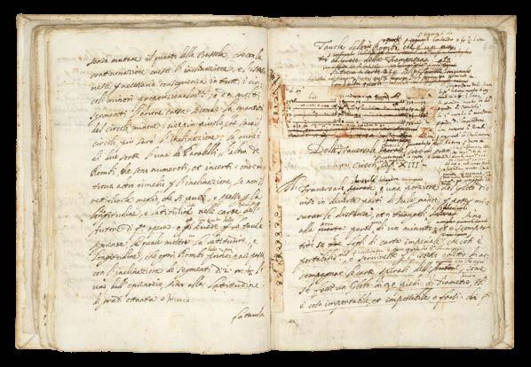
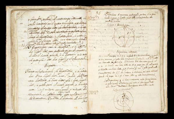
This section of the ‘Direttorio’ is composed of early versions of important passages in Books One, Two and Five of ‘Dell’Arcano del mare’: a compendious study of naval theory and practice, treating of longitude and latitude and Great Circle sailing. They appear as drafts and revisions of twenty-eight chapters (lacking part of Chapters 19 and 20); but the order and headings of the chapters does not correspond with that of the ‘Dell’arcano del mare’.
The subjects in this part of the ‘Direttorio’ cover many of those in the ‘Dell’arcano del mare’: how to navigate along known and unknown
coasts; knowing which winds prevail; currents and the times of tides of places; how to use ‘Tables of Ephemerides’ for celestial observation; how to ascertain magnetic declination values with a meridian compass across the globe. In the field of cartography, Dudley considers how to determine latitudes and longitudes across the oceans, and explains the errors of “horizontal” or common charts in navigation. He proposes the use of mathematical instruments, as well as celestial observation, to accomplish correct navigation. Interestingly, he also proposes to establish longitude by the use of a clock “oriuolo mecuriale”. As in the ‘Dell’arcano del mare’, Dudley focusses on his preferred method of navigating by Longitude and Great Circle sailing - using his own invention of tables of “traversali sfericali”, and his charts based on what we now call “Mercator’s projection”, giving his latitudinal values.
Here the ‘Direttorio’ is heavily re-worked with some passages entirely re-written by the author in the margins, and in places makes direct reference to the text of the ‘Dell’arcano del mare’. This suggests that some parts of the ‘Direttorio’ may well have been written during, or after, the text for the ‘Dell’arcano del mare’, was being printed. On page 3 of Dudley’s autobiographical ‘proemio’, Dudley adds “come Arcano” – “like the Arcano”; on page 122, a reference to the “master of the Arcana, who holds the secret of longitude” is mentioned; further on pages 21- 22 when in discussing the method of using the “spiral” charts (Cap 8 and 9), Dudley refers to the “carte hydrografice del 2[do] libro” – “hydrographic charts in Book 2”, which is exactly where they appear in the published ‘Dell’arcano del mare”.
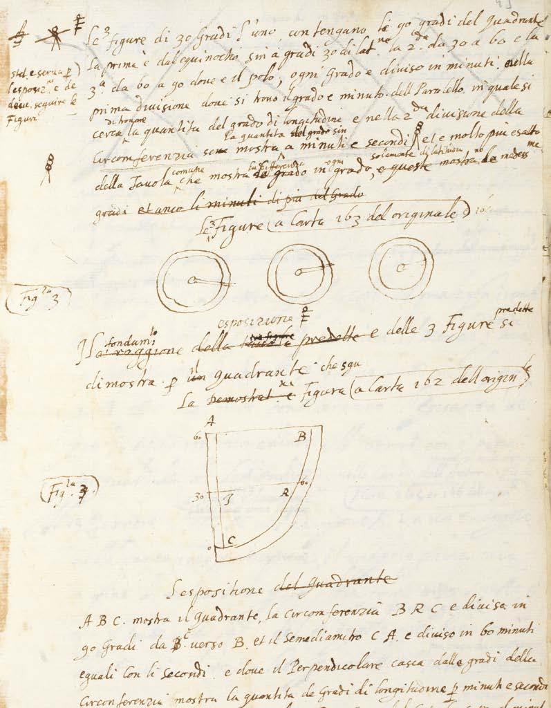
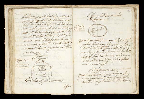
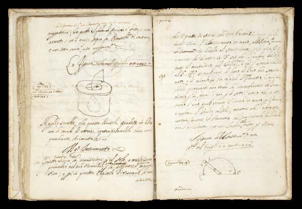
These chapters of the ‘Direttorio’ are illustrated with numerous small drawings, and a number of larger diagrams, but the numbering of the figures, while referencing specific charts, do not correspond to the engraved figures in the published ‘Dell’arcano del mare’. It is possible that the references may correspond to the set of 268 manuscript charts now preserved in the BSB, in three volumes (Cod icon 138-140).
Similarly, these chapters also contain text not found in the published ‘Dell’arcano del mare’. Dudley describes the likely effects of bad weather in high latitudes above 66°N, and the usual weather in temperate and tropical latitudes (pages 133-134); and ‘Cap XXIV’ contains Dudley’s explanation of how to find the North Star with a diagram (page115).
Pages 140-146 Addenda
Apparently new text, in which Dudley formulates his ideas on the application of science to navigation on the high seas: “la 2 da parte di q[ues]to libro tratta de naviagare con scienza in alto mare Cap 6”; incomplete sections on astronomical and military subjects; and a few additional notes in other hands.
Dudley and the Medicis
Robert Dudley (1573-1649) first published his ‘Secrets of the Sea’ in 1646 when he was 73. It was the culmination of his life’s work, and a testament to his close bond with one of the greatest ruling families of Italy, it is dedicated to Ferdinand II de’Medici. For his services to three Medici Grand Dukes of Tuscany (Ferdinand I, Cosimo II, and Ferdinand II), as philosopher, statesman, civil and military engineer, naval architect, hydrographer and geographer, mathematician and physician, Dudley was rewarded with status during his lifetime, a public funeral and a memorial monument upon his death.
Dudley was the son of the Earl of Leicester (the one time favourite of Elizabeth I) and Lady Douglas Sheffield, the widow of Lord Sheffield. Although born out of wedlock, Robert received the education and privileges of a Tudor nobleman. He seems to have been interested in naval matters from an early age, and in 1594, at the age of 21, he led an expedition to the Orinoco River and Guiana. He would later, like all good Tudor seamen, sack Cadiz, an achievement for which he was knighted.
His success upon the high-seas was not matched, unfortunately, by his luck at court, and at the beginning of the seventeenth century he was forced to flee, along with his cousin Elizabeth Southwell, to Europe. Eventually, in 1606, he ended up in Leghorn, Italy, which he set about turning into a great international naval and commercial seaport, in the service of Ferdinand I.
Dudley, successful at last, married his cousin, converted to Catholicism, helped Ferdinand wage war against the Mediterranean pirates, by designing and building a new fleet of fighting ships for the Italian navy, served as Grand Chamberlain to three Grand-Duchesses of Tuscany in succession: Maria Maddelena, widow of Cosimo II; then Christina of Lorraine, widow of Ferdinand I; then to Vittoria della Rovere, Princess of Urbino, and wife of Ferdinand II, who created Dudley Duke of Northumberland.
Gian Carlo de’ Medici (1611-1663)
It is not surprising that Dudley should dedicate his ‘Direttorio’ to his greatest patrons, Grand Duke Ferdinand II, and Gian Carlo de’ Medici. Nor that they should have owned examples of his greatest work, ‘Dell’arcano del mare’. What is very pleasing is that this working manuscript for the ‘Direttorio’, should also once have been in the possession of at least two other previous owners of both Gian Carlo’s first edition ‘Dell’arcano del mare’: Pietro Bigazzi, Florentine bookseller; and Sir John Temple Leader. Gian Carlo de’Medici shared Dudley’s passion for all things maritime. The second son of Cosimo II de’Medici, Gian Carlo was made “High Admiral of the Tuscan Navy” in 1638, held the title of “General of the Mediterranean Sea”, and appointed “General of the Spanish Seas” by Philip IV of Spain during the 40 years war. In 1644, he reluctantly
resigned his naval appointments when Pope Innocent X appointed him Cardinal. As a young and attractive man, he found the religious life a trial, and in 1655, the Pope returned him to Florence, after he became a bit too friendly with Queen Christina of Sweden. There he remained until his death, working in close collaboration with his brothers, in the government and cultural enrichment of the grand duchy. Gian Carlo was “passionate about science, letters and above all music. Founded the Accademia degli Immobili and contributed to the construction of the Teatro della Pergola, inaugurated in 1658.... and enrichment of the Galleria Palatina di Palazzo Pitti” (Cardella, Lorenzo. ‘Memorie storiche de’ cardinali della Santa Romana Chiesa’. Rome, Stamperia Pagliarini, 1793, VII, 51).
The close bond between Dudley and Gian Carlo is attested to by a letter written in September of 1638 from Dudley to Gian Carlo, who had just been appointed High Admiral of the Tuscan Navy, offering his homage and swearing his fealty, saying, that “if his nautical experience of many years merited employment in the service of his Highness, he, though old, would be always ready to obey the Admiral’s commands” (John Temple Leader in his ‘Life of Sir Robert Dudley,...’ 1895, pages 115-116).
Domenico Maria Manni, Pietro Bigazzi, and the Biblioteca Moreniana (Moreniana Library)
A Florentine bookdealer and collector, Pietro Bigazzi was also a librarian, and clerk of the Academia della Crusca, from 1854. His large library had come from a number of sources, including that of Domenico Maria Manni (1690-1788) director of the Bibilioteca Strozzi, who has supplied the four pages of bio-bibliography at the beginning of the ‘Direttorio’. See ‘Manoscritti e alcuni libri a stampa singolari esposti e annotati da Pietro Bigazzi’, Firenze, Tipografia Barbera, 1869, in which it is noted: “manuscript ceded, many years ago, to Mr. Temple Leader, a distinguished English gentleman, domiciled among us; solicitous repairer of the Tuscan Memoirs”.
The Biblioteca Moreniana “was created when the Provincial Deputation of Florence acquired the bibliographic collection that had belonged to Pietro Bigazzi.
The collection of literary writings, the majority of which were part of the library owned by Domenico Maria Manni and Domenico Moreni, consists mostly of records on Tuscan history and culture. Later, several other literary collections from well-known scholars and collectors of Tuscan antiquities were added. In 1942, the library was housed in Palazzo Medici Riccardi and opened to the public. Other historically significant collections of manuscripts were added later. Today the library is managed by the Metropolitan City of Florence” (Biblioteca Moreniana, online).
John Temple Leader (1879-1903)
Possessed both the first and second editions of Dudley’s ‘Dell’Arcano dell mare’, and this manuscript, the ‘Direttorio Marittimo’. He describes his relationship with Pietro Bigazzi, the Florentine bookdealer from whom he purchased all three items, in his biography of Dudley: “Long ago I bought from Signor Pietro Bigazzi, together with many other books which had belonged to Dudley, the first two volumes and the fourth of the ‘Arcano del Mare’, the first edition of his great work which was published at Florence in 1646-47. The third volume was wanting, perhaps lent to some friend who had forgotten to return it. Two or more years after this, Signor Bigazzi brought me, as a New Year’s gift, the missing volume of this very same incomplete set. He had discovered it on the low wall or ledge of the Palazzo Riccardi, and bought it from the salesman who had permission to sell his books there. My joy on thus unexpectedly receiving the missing part may be easily imagined by collectors and lovers of old books. The four volumes thus happily reunited after a long separation were in the old binding with the arms of a Cardinal of the Medici family” (pages 18-19).
Other Dudley manuscripts related to ‘Dell’arcano del mare’ Manni noted that the Palatina di Pitti library held two imperial folio volumes, in manuscript, of “Marine Treatises” by Dudley. They were on marine architecture, begun before 1610 in English, and continued by Dudley in Italian until about1635 (see Maria Enrica Vadala: ‘Il Trattato dell’architettura maritima di Roberto Dudley, storia e dispersione di un manoscritto’, Studi secenteschi, vol. 61 (2020), pp. 193-237) .
The Bayerische Staatsbibliothek holds several manuscripts by Dudley related to the ‘Dell’arcano del mare’, including: a of 268 manuscript charts, in three volumes, (Cod icon 138-140); and another relating to naval architecture and the conduct of naval warfare (Cod.icon 221) British Library (Add MS 22811).
Provenance:
1. Domenico Maria Manni (1690-1788), polymath, editor and publisher, also a member of Academia dell Crusca, and Director of the Biblioteca Strozzi, who has supplied 4 pages of bio-bibliography at the front of the manuscript;
2. Pietro Bigazzi, Florentine collector, librarian, and bookseller, a number of annotations in pencil, including on the flyleaf (“Ms citato del Targioni negli aggrandimenti Vole 10 pag.80”), sold to:
3. Sir John Temple Leader (1879-1903), who also bought Gian Carlo de’ Medici’s (1611-1663), first edition of ‘Dell’Arcano del mare’, and a second edition, from Bigazzi;
4. By descent to Richard Luttrell Pilkington Bethell, 3rd Baron Westbury (1903-1917), who sold Leader’s collections “piecemeal”.
The first atlas on Mercator’s Projection
DUDLEY, Robert
Dell’arcano del Mare di D. Ruberto
Dudleo Duca di Northumbria, e Conte di Warwich …
Publication
Florence, Giuseppe Cocchini, 1661.
Description
Six parts in two volumes, folio (550 by 425mm), two printed titles with engraved vignettes, traces of removed library stamps, double-page plate of the author’s patent of nobility, 216 engraved plates (of which 66 have volvelles or moveable parts), 146 engraved charts (of which 88 are double-page); contemporary calf, panelled, foliate roll-tool border, foliate corner and central tool, spine in seven compartments separated by raised bands.
The ‘Arcano de Mare’ is one the “greatest atlases of the world” (Wardington). This sumptuous atlas, first published in 1646 when its author, Robert Dudley, was 73, was not only the first sea atlas of the world, but also the first to use Mercator’s projection; the earliest to show magnetic deviation; the first to show currents and prevailing winds; the first to expound the advantages of ‘Great Circle Sailing’ – the shortest distance between two points on a globe; and “perhaps less importantly the first sea-atlas to be compiled by an Englishman, all be it abroad in Italy” (Wardington)
Robert Dudley (1573–1649) was the son of the Earl of Leicester (the one time favourite of Elizabeth I) and Lady Douglas Sheffield, the widow of Lord Sheffield. Although born out of wedlock, Robert received the education and privileges of a Tudor nobleman. He seems to have been interested in naval matters from an early age, and in 1594, at the age of 21, he led an expedition to the Orinoco River and Guiana. He would later, like all good Tudor seamen, sack Cadiz, an achievement for which he was knighted.
His success upon the high-seas was not matched, unfortunately, by his luck at court, and at the beginning of the seventeenth century he was forced to flee, along with his cousin Elizabeth Southwell, to Europe. Eventually he ended up in Florence at the court of Grand Duke Ferdinand I of Tuscany, where he not only married his cousin and converted to Catholicism, but also help Ferdinand wage war against the Mediterranean pirates. In his spare time he set about his great life’s work: the ‘Arcano del Mare’.
The atlas is divided into six books, or sections: book one deals with longitude; book two covers errors in the then-existing sea charts, and includes the portolano for the Mediterranean and 15 general maps; book three deals with naval and military discipline, notably the former, and there is a long section on naval tactics, especially remarkable for a plan of the construction of a navy in five grades of vessel; book four describes the method of designing and building ships of the “Galerato” and “Galizaba” types and is concerned with naval architecture, giving the lines and dimensions of ships; book five is devoted entirely to navigation and methods of measuring the sun’s declination and the relative positions of the stars; book six contains the sea atlas.
For the beautifully engraved charts, Dudley employed the services of Antonio Francesco Lucini. Lucini states in the atlases that the work took him 12 years to complete and required 5,000lbs of copper. The charts are by English and other pilots, and it is generally accepted that the work was both scientific and accurate for the time. It is assumed that Dudley used the original charts of Henry Hudson, and for the Pacific Coast of America used his brother in-law Thomas Cavendish’s observations.
Contents:
VolumeI
Book 1. [4], 30pp., printed title with plate of a navigational instrument, [2] engraved facsimile of the Patent, 30 engravings on 28 sheets, 22 of which have moveable volvelles (of these, 2 have a string).
Book 2. 24pp., 15 engravings on nine sheets, 9 of which have volvelles, and 15 large engraved charts (six double-page or folding), of which four relate to America, five to the European coasts, four to Asia, and two to Africa.
Book 3. 25pp., 8 engraved plates on 6 sheets (three plates being of ships in battle formation, etc.) including four sheets with plates of fortifications and cities with walled defences.
Book 4. 12pp., 18 engravings on 14 sheets, of which seven are double page, all designs of ships in plan and in section.
Book 5. 26, [2]pp., 145 engravings on 89 sheets, 38 have moveable volvelles and additional 5 have a string.
Volume II
Book 6. [4], 41pp., title with plate of the Great Bear, 131 engraved charts (82 double-page), 58 covering Europe, Greenland, and Canada, 17 of Africa, 23 of Asia, and 33 of America.
Rarity
Rare. The last example to come on the market sold for £731,000 in Christies London, 2019, and, before that, $824,000 in the Frank Streeter sale, Christies New York, 2007.
Provenance
1. Sir John Temple Leader (1879-1903); first Villa Maiano, and then at the Castello di Vincigliata near Fiesole, which he purchased in 1855 and restored in neo-medieval style, furnishing and richly embellishing it with paintings and furniture of the fourteenth and fifteenth centuries. Leader possessed both the first and second editions of Dudley’s ‘Dell’Arcano dell mare’, and Dudley’s manuscript, the ‘Direttorio Marittimo’. He describes his relationship with Pietro Bigazzi, the Florentine bookdealer from whom he purchased all three items, in his biography of Dudley: “Long ago I bought from Signor Pietro Bigazzi, together with many other books which had belonged to Dudley, the first two volumes and the fourth of the ‘Arcano del Mare’, the first edition of his great work which was published at Florence in 1646-47. The third volume was wanting, perhaps lent to some friend who had forgotten to return it. Two or more years after this, Signor Bigazzi brought me, as a New Year’s gift, the missing volume of this very same incomplete set. He had discovered it on the low wall or ledge of the Palazzo Riccardi, and bought it from the salesman who had permission to sell his books there. My joy on thus unexpectedly receiving the missing part may be easily imagined by collectors and lovers of old books. The four volumes thus happily reunited after a long separation were in the old binding with the arms of a Cardinal of the Medici family” (pages 18-19).
2. By descent to Richard Luttrell Pilkington Bethell, 3rd Baron Westbury (1903-1917), who sold Leader’s collections “piecemeal”.
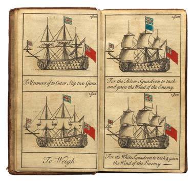
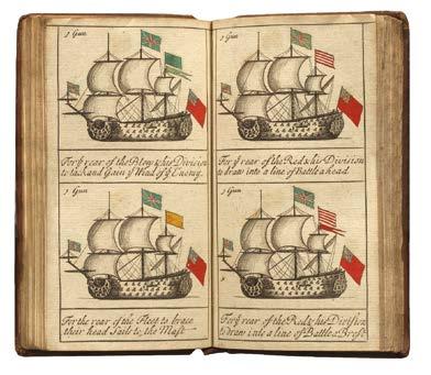
GREENWOOD, Jonathan
The Sailing and Fighting Instructions or Signals as they are Observed in the Royal Navy of Great Britain
Publication [?London, 1714-1715].
GREENWOOD, Jonathan
Description
The Sailing and Fighting Instructions or Signals as they are Observed in the Royal Navy of Great Britain.
Publication [?London, 1714-1715].
Duodecimo (149 by 77 mm), unpaginated, engraved title, 2pp. dedication, 70 engraved plates, 65 with original hand colour, manuscript calculation in ink to front free endpaper, dated in a contemporary hand March 4 to title page, contemporary sheep, blind stamped and tooled, spine in six compartments separated by raised bands, title piece to spine, title in ink.
References
Description Duodecimo (149 by 77 mm), unpaginated, engraved title, 2pp. dedication, 70 engraved plates, 65 with original hand colour, manuscript calculation in ink to front free endpaper, dated in a contemporary hand March 4 to title page, contemporary sheep, blind stamped and tooled, spine in six compartments separated by raised bands, title piece to spine, title in ink.
Commader Hilary P. Mead, ‘The Earliest English Signal Book’, Proceedings of the US Naval Institute 61 (1935); William Gordon Perrin, British Flags, Their Early History, and Their Development at Sea: With an Account of the Origin of the Flag as a National Device, (Cambridge: Cambridge University Press, 1922); James Tritten, Doctrine and Fleet Tactics in the Royal Navy, (PP Publishing, 2015).
$10,000
References Commader Hilary P. Mead, ‘The Earliest English Signal Book’, Proceedings of the US Naval Institute 61 (1935); William Gordon Perrin, British Flags, Their Early History, and Their Development at Sea: With an Account of the Origin of the Flag as a National Device, (Cambridge: Cambridge University Press, 1922); James Tritten, Doctrine and Fleet Tactics in the Royal Navy, (PP Publishing, 2015).
The first printed English signals book
The first printed English signals book
A scarce naval signals book, the first to be printed in the English language. The book was the enterprising production of Jonathan Greenwood. Greenwood was born about 1656 and apprenticed in June 1670 in the Stationers’ Company, where he was made free in 1679. He presumably had naval connections, but no other works of his are known and no other record of him as a publisher survives (Mead).
A scarce naval signals book, the first to be printed in the English language.
The book was the enterprising production of Jonathan Greenwood. Greenwood was born about 1656 and apprenticed in June 1670 in the Stationers’ Company, where he was made free in 1679. He presumably had naval connections, but no other works of his are known and no other record of him as a publisher survives (Mead).
The growth of the British navy led to a demand for a record of the signals used at sea. Commanders might have to manage “as many as a hundred ships in battle, many of which were still privateers”: the vessels might not be trained in Navy discipline (Tritten).James II was the first to co-ordinate British flag signals while still Duke of York, and various manuscript works followed, in an inconvenient folio size.
The growth of the British navy led to a demand for a record of the signals used at sea. Commanders might have to manage “as many as a hundred ships in battle, many of which were still privateers”: the vessels might not be trained in Navy discipline (Tritten). James II was the first to co-ordinate British flag signals while still Duke of York, and various manuscript works followed, in an inconvenient folio size.
Greenwood saw the opportunity for a small, cheaper book aimed at “Inferior Officers who cannot have recourse to the Printed Instructions”; although the instructions to the fleet were confidential, the signals were not (Perrin). Each signal is shown by an engraving of a ship displaying the flags of the appropriate signal, coloured where necessary, with an explanation underneath. In the dedication, he explains that he has “disposed matters in such a manner that any instruction may be found out in half a minute”.
Greenwood saw the opportunity for a small, cheaper book aimed at “Inferior Officers who cannot have recourse to the Printed Instructions”; although the instructions to the fleet were confidential, the signals were not (Perrin). Each signal is shown by an engraving of a ship displaying the flags of the appropriate signal, coloured where necessary, with an explanation underneath. In the dedication, he explains that he has “disposed matters in such a manner that any instruction may be found out in half a minute”.
Although Greenwood’s work was not an official publication, it was used by at least one Mediterranean fleet commander (Tritten).
Although Greenwood’s work was not an official publication, it was used by at least one Mediterranean fleet commander (Tritten).
The book is dedicated to the six Lords Commissioners of the Admiralty, including Sir George Byng, whose son John, also an Admiral, was famously executed in 1757 “pour encourager les autres”, according to Voltaire, after failing to relieve the British garrison during the Battle of Minorca.
The book is dedicated to the six Lords Commissioners of the Admiralty, including Sir George Byng, whose son John, also an Admiral, was famously executed in 1757 “pour encourager les autres”, according to Voltaire, after failing to relieve the British garrison during the Battle of Minorca.
A large cross-staff (750 by 340mm) Ebony staff (sawn at each end), signed “VOC” and dated “1798”, inscribed with degrees and stars, three later pearwood vanes, each with winged brass set screws.
References Ackermann, ‘Epact Scientific Instruments of Medieval and Renaissance Europ, online; Bruyns, ‘The Cross-Staff: History and Development of a Navigational Instrument’ (1994).
$25,000
“I took my staff... and cut it asunder” (Zekariah)
A previously unrecorded, and exceptionally rare cross-staff, inscribed “VOC” in the penultimate year of the Dutch East India Company’s existence, before it was disbanded in 1799. Significantly, the ebony staff is sawn off at both ends, possibly in a symbolic act of destruction, commemorating the dissolution of the VOC.
This cross-staff has not been recorded by Bruyns in his definitive census of these distinctive navigational instruments, however, it is very similar to item 55, which is dated 1748. According to Bruyns, fewer than 100 cross-staffs are known to survive, in any condition. Of these, only about 40 bear at least one original vane, and most are in institutions. The cross-staff was the preferred navigational instrument of the VOC until 1750, when it was supplanted by the octant, and then later, the sextant.
The cross-staff was a navigational instrument that was used “to measure angles and altitudes, consisting of a trigonometrically graduated staff and one or more perpendicular vanes moving over it. First described in about 1342 by the Jewish philosopher and scientist Levi ben Gerson and originally used for astronomical and surveying purposes, it became a mariner’s navigational instrument in the 16th century (also known as ‘ballastella’, ‘Jacob’s staff ‘ or ‘fore-staff’). The instrument was mainly used for finding the latitude by measuring the altitude of the polar star and for measuring the altitude of the sun. In the latter use, the observer had to face the sun and this inconvenience led to the development of the back-staff. To measure the altitude of a celestial body, the eye-end of the staff was placed near the observer’s eye and the other end half way between the horizon and the celestial body. The vane was then slid along the staff until its upper edge appeared to touch the celestial body, while the lower edge appeared to touch the horizon. The altitude could then be read off the staff” (Ackermann).
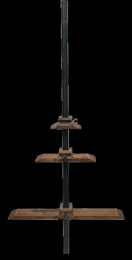
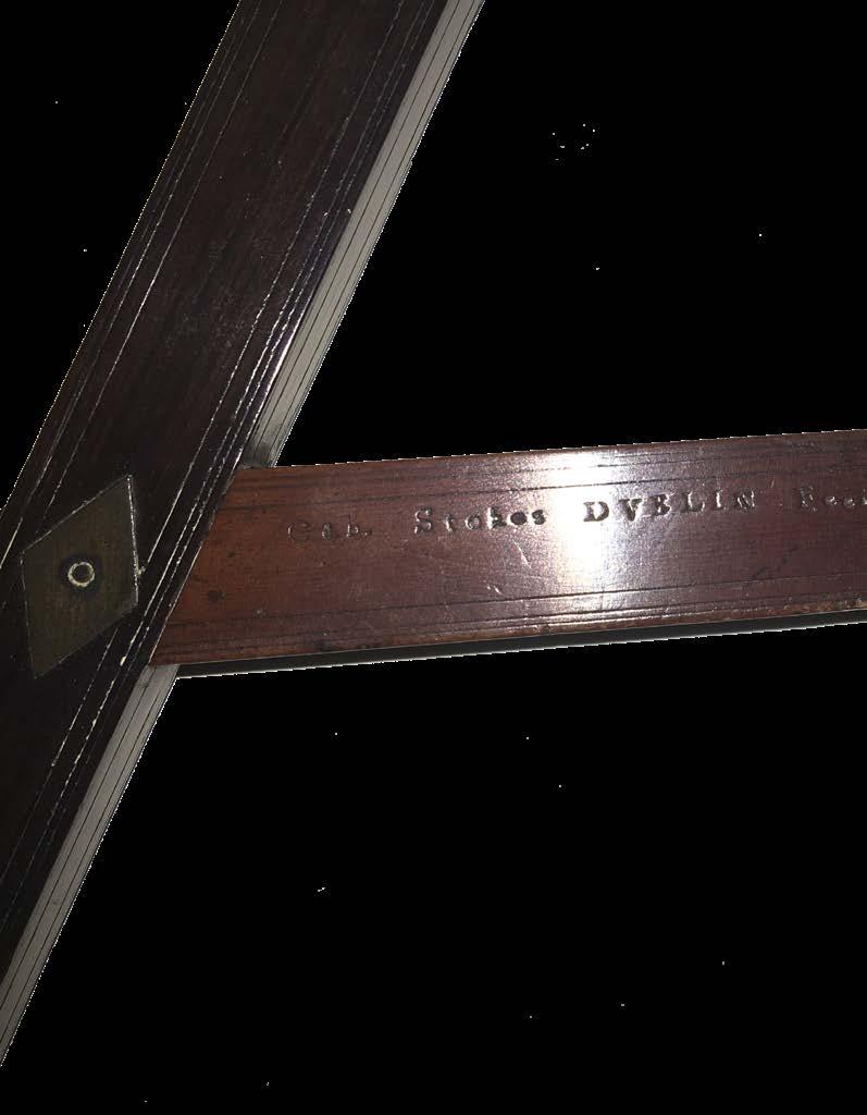
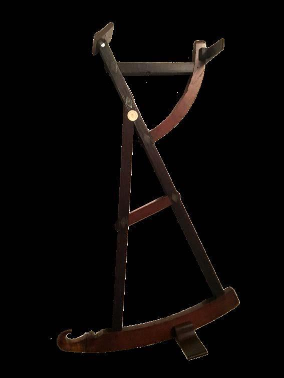
STOKES, Gabriel
Back-staff.
Publication Dublin, [c1750].
Description
A large back-staff (610 by 380mm) Rose, pear wood and brass, signed “Gab. Stokes Dvblin Fecit”, inscribed with degrees, three later pear wood vanes.
References Turner, Gerard L’Estrange. Scientific Instruments, 1500-1900: An Introduction. Berkeley: University of California Press, 1998.
$25,000
“But, now the sun is just above our head, we do those shadows tread” (John Donne)
The Backstaff
“Backstaff” is the name given to any instrument that measures the altitude of the sun by the projection of a shadow. Users kept the Sun to their back - hence the name - and observed the shadow cast by a pointer, or “vane”, to enable calculations of the elevation of both the user and the sun from the horizon. This method was preferable to the cross staff as it avoids direct, and hazardous, observation of the sun’s light. The idea for measuring the sun’s altitude using back observations originated with Thomas Harriot, but it was popularised by the English navigator John Davis, who described it in his book ‘Seaman’s Secrets’ in 1594. It is, therefore, Davis’ name that is most remembered, and the backstaff is also known as a “Davis Quadrant”
Backstaffs were typically constructed using a dark wood such as ebony or rosewood in a triangle shape with adjustable vanes – used for sighting; and two arcs – used for taking angle measurements. One arc was 30 degrees, the other was 60 degrees. To use the backstaff, the navigator with his back to the sun, places the instrument on their shoulder. To find the altitude, the navigator would move the vanes along the arcs, and view the horizon through a small slit. They would move the shadow vane on the smaller arc until the edge of the vane casts a shadow on the slit of the horizon vane. While doing this, the navigator would also look through a peephole in the vane on the larger arc and through a slit in the horizon vane to view the horizon. This allows the navigator to find the altitude of the sun by viewing the horizon and the sun’s shadow at the same time through the horizon vane
The Instrument Maker
Gabriel Stokes (1682-1768), was a mathematical instrument maker and Deputy Surveyor General of Ireland. He lived at The Dial, Essex Street, Dublin. “His first signed map (1716) was a precursor to his most productive period, from the 1720s into the middle of the following decade. He mapped (1725) the course of the River Liffey downstream to Dublin Bay. After producing maps of Christ Church (1700) and St Patrick’s cathedrals (1716, 1725), Stokes also surveyed (1718–1730s) various properties and estates held by the archbishopric of Dublin. More closely associated with Dublin than any other private surveyor during the century, throughout his career he surveyed various parts of the city although, apart from a poor-quality map of Co. Dublin (1750), he never mapped either city or county. Stokes, with Thomas Cave, surveyed (1734) and mapped the site of the houses of parliament. The following year Stokes published A scheme for effectively supplying every part of the city of Dublin with piped water (1735), to which he appended ‘The mathematical cabinet of the hydrostatical balance unlock’d’, presenting his plans for improving the city’s water supply, and eliciting various responses from Richard Castle and others; both Stokes and Castle were asked to prepare schemes.
It was as deputy surveyor general of Ireland (1748–52) that Stokes made perhaps his most lasting contribution. Appointments were usually made on a political basis, and here Stokes was unusual for his skilled training and experience covering his remit. Establishing a certification scheme (1750), issuing certificates by the following May, and probably examining candidates himself, Stokes did a great deal to improve contemporary surveying standards. In 1767 he advertised a surveying textbook, selling all the instruments therein described including the pantrometron, a device he invented. The first Irishborn instrument maker, he took on at least four apprentices over his career”.
(Dictionary of Irish Biography)
Provenance
1. From the scientific instrument collection of Mr Howard Dawes, Craycombe House Collection, Pershore, Worcestershire.
2. Zuylenburgh Planetarium, Oud-Zuilen.
Bruyns, W. F. J. Mörzer, and Richard Dunn, ‘The Backstaff, or Davis Quadrant’ in ‘Sextants at Greenwich: A Catalogue of the Mariner’s Quadrants, Mariner’s Astrolabes Cross-staffs, Backstaffs, Octants, Sextants, Quintants, Reflecting Circles and Artificial Horizons in the National Maritime Museum’, Greenwich, London, Oxford University Press, 2009.
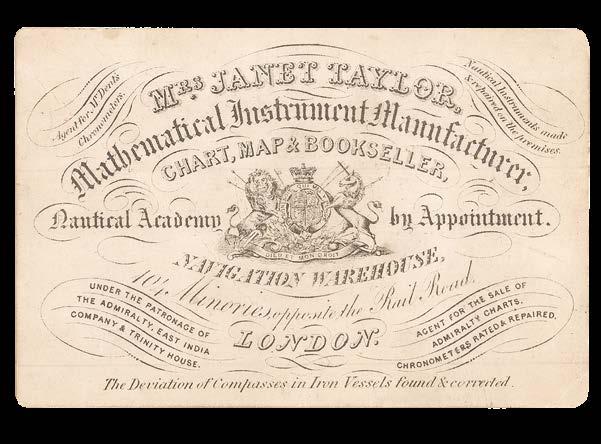
TAYLOR, Janet
Mrs. Janet Taylor, Mathematical Instrument Manufacturer, Chart, Map & Bookseller, Nautical Academy by Appointment.
Publication [London], [c.1845-1860].
Description Engraved trade card. With Croucher & Croucher, ‘Mistress of Science’, 2016.
Dimensions 75 by 115mm. (3 by 4.5 inches).
References Croucher & Croucher, ‘Mistress of Science’, 2016; Fisher, ‘The Makers of the Blueback Charts’, 2001.
$7,000
“one of the most remarkable and talented women of the nineteenth century” (Croucher & Croucher)
Trade card of the “redoubtable” Janet Taylor, instrument maker, astronomer, mathematician, author, and “intrepid chart-seller” (Fisher, p.12), one of the most significant figures in the male-dominated world of nineteenth-century navigation, and the only woman in 235 years to patent a nautical instrument. Taylor (1804-1870) established her business, alongside her husband, George, whose role was, at best, “nominal” (Croucher & Croucher, p.3), in the early 1830s. By 1845, she was operating from the 104 Minories premises advertised on the present trade card, manufacturing nautical instruments (among them sextants, quadrants, compasses, and barometers), selling charts, adjusting compasses, and teaching at ‘Mrs Janet Taylor’s Nautical Academy’. Not only was Taylor an astute businesswoman, she was also an inventor, patenting, in 1834, the “Mariner’s Calculator” (this, however, met with little success, deemed by the Admiralty too complex for sailors to use), and a prolific author, with selected works including ‘Principles of Navigation Simplified’ (1834), which ran to three editions, and ‘Luni-Solar and Horary Tables’, first published in 1833, when Taylor was heavily pregnant with her second child, which would go on to run to seven editions.
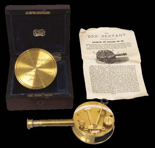
CARY, John
Brass Box Sextant.
Publication London, Cary, [c.1860].
Description
Brass box sextant, signed by John Cary, brass body with sliding shutter sight and dark lens, wheeled rack drive to index arm reading from 0 to 150 degrees on the silvered scale, with magnifying lens to vernier, with separate telescope, the lid engraved Royal Military College, with engraved dedication.
Dimensions
Sextant: (Diameter) 75 (3 inches); Case: 120 by 50 by 100mm (4.75 by 2.5 by 4 inches).
$2,000
Rare Pocket Sextant
A fine brass box sextant by the renowned scientific instrument maker John Cary.
The instrument was presented to William S. Cooke, whose name is engraved on the instruments lid:
“Royal Military College. Presented to Gentleman Cadet William S. Cooke for Attention to and Progress in Military Surveying, June, 1860.”
According to the 3rd July 1860 edition of The London Gazette, Gentleman Cadet William Smith Cooke from the Royal Military College was appointed to the 2nd Regiment of Life Guards in the Summer of that year. This Cary box sextant would likely have been a presentation gift to commemorate this occasion.