& PARK MASTER PLAN

DECEMBER
GREENWAY
2022
Produced For North Carolina Department of Natural and Cultural Resources 109 E. Jones Street Mail Service Center 4601 Raleigh, NC 27601 Produced By Destination by Design 136 Furman Road, Suite 6 Boone, NC 28607 828.386.1866

ACKNOWLEDGMENTS
PROJECT OVERSIGHT COMMITTEE
Chad Barrow
NC School of Science and Math
Judy Francis NC Division of Parks and Recreation
Trey Hatcher NC Department of Health and Human Services
Sandy Hoilman Western Piedmont Community College
Bill Holmes NC Department of Natural and Cultural Resources
Phillip Luckadoo City of Morganton
Mark Patrick NC School for the Deaf
Shane Prisby Burke County
Sally Sandy City of Morganton
Chastan Swain NC Hometown Strong
COMMUNITY STAKEHOLDERS
Grant Buckner
Catawba Riverkeeper
Andrew Kota and Tom Kenney
Foothills Conservancy of NC
Bryant and Linda Lindsey
Overmountain Victory North Carolina State Trail - Friends
Geoff Smith
Wildlands Engineering
Lee Kiser
Community Trails Advocate
CONTENTS 1 INTRODUCTION 2 SITE ANALYSIS & DESIGN DETERMINANTS 3 3.1 Community Surveys ................. 18 3.2 Public Engagement & Input .... 20 PUBLIC INPUT & DRAFT PLAN 4 4.1 Final Greenway Trail Alignment .................................... 26 4.2 Greenway Trail Types ............... 32 4.3 Hunting Creek Park Master Plan ................................. 34 RECOMMENDATIONS 5 5.1 General Implementation Recommendations ................... 40 5.2 Physical Needs Summary & Estimate of Probable Costs ..... 42 IMPLEMENTATION A 01 NRCS Soils Map ......................... 46 02 Public Engagement Meeting Comments .................................... 47 03 Hunting Creek Stream Restoration and Enhancement Plan ................................................ 48 04 Duke Energy Shared Use Path/Trails Requirements ........ 50 05 NCSHP0 Project Review Response ...................................... 51
1.1 Background 02 1.2 Goals ............................................ 03 1.3 Planning Process ....................... 04 1.4 Plan Organization ..................... 05 2.1 Study Area Context 08 2.2 Previous Plans............................ 10 2.3 Natural & Built Environment .. 12
APPENDIX
MAPS Map 01: Regional Context ................................ 09 Map 02: Final Greenway Alignment .................. 27 Map 03: Hunting Creek Greenway - Section One .................................................... 28 Map 04: Hunting Creek Greenway - Section Two .................................................... 29 Map 05: Hunting Creek Greenway - Section Three .................................................. 30 EXHIBITS Exhibit 01: Study Area Opportunities & Constraints ........................................................ 14 Exhibit 02: Hunting Creek Stream Restoration ........................................................ 26 Exhibit 03: College Street Redesign Project ... 28 Exhibit 04: Hunting Creek Relocation ............. 29 Exhibit 05: Box Culvert Under I-40.................. 30 Exhibit 06: Hunting Creek Park Master Plan ... 35 Exhibit 07: Hunting Creek Park Trail Types ..... 36 Exhibit 08: Precedent Images ........................... 37 Exhibit 09: Potential Grant Funding Sources .. 40 Exhibit 10: Estimate of Probable Costs - Hunting Creek Greenway and Trails ............................... 42 Exhibit 11: Estimate of Probable Costs - Hunting Creek Park ........................................................ 43


1 The Hunting Creek Greenway and Park Master Plan serves as a guide for the development of a community park and approximately two-mile long trail along Hunting Creek. INTRODUCTION 1.1 Background 1.2 Goals 1.3 Planning Process 1.4 Plan Organization
1.1 BACKGROUND
In the late 1800s, the State of North Carolina acquired approximately 300 acres of land in Morganton and opened what is currently known as Broughton Hospital. In 1891, the City of Morganton donated approximately 100 acres next to the Hospital for the NC School for the Deaf which opened in 1894. Additional land in the area was acquired by state and county agencies in the early and mid-1900s, and the construction of Western Piedmont Community College, Burke County Sheriff’s Office, and the Burke County Agricultural Building occurred in the second half of the century. Over time, approximately 750 acres of contiguous public land was amassed, and facility development occurred along the perimeter of the site on the hills that rise above Hunting Creek.

Recently, the Re-imagining Broughton: A Reuse Study of Historic Broughton Campus planning process identified redevelopment opportunities for public and private investment. The plan addressed recommendations for civic, residential, and commercial uses within the 750 acre site. Since that time, the NC School of Science and Math has developed its new western campus on property formerly managed by the NC School for the
Deaf, and a 240 unit private residential development has occurred on the eastern side of the property.
Local residents have often considererd the remaining open space a significant community asset. It currently serves as an informal public green space utilized by students, state employees, and residents of Morganton. A number of plans have laid a framework for the expansion and development of public recreation facilities into and within this open space. Hunting Creek, which is classified as an impaired stream due to compromised ecological and biological integrity, has also been identified as an ideal opportunity for stream restoration and enhancement.
The Hunting Creek corridor provides a pastoral setting among rolling hills and grassy fields within the city limits of Morganton. A greenway within the corridor would be a natural, educational, and recreational asset for Morganton, Burke County, and western NC.
“The 2018 City of Morganton Comprehensive Recreation Master Plan identifies the Broughton study area as an opportunity for recreation development.”
1.2 GOALS
Access & Connectivity
Provide access to Hunting Creek and connect educational facilities and future residential and commercial redevelopment opportunities to downtown Morganton and a developing local, regional, and state greenway and trail system.
Quality of Life
Enhance quality of life for current and future residents of Morganton and Burke County through outdoor infrastructure that promotes educational experiences, active living, and recreational opportunities for physical, mental, and social well-being.

Economic Development
Promote economic growth by creating a community asset and recreational amenity that can act as a catalyst for public and private investment.
Ecological Restoration & Enhancement
Identify stream restoration and enhancement opportunities to improve streambed and bank stability, aquatic habitats, and the water quality of Hunting Creek.
Poised for Grant Funding
Ensure grant competitiveness by adhering to planning guidelines required by the North Carolina Parks and Recreation Trust Fund (PARTF) and other grant funding sources.


3
1.3 PLANNING PROCESS
Project Launch
June 2022
Discovery & Analysis
Final Plan Development

4
• Develop Working Maps • Kick-off Meeting
June-July 2022 • Previous Plan Review • Existing Conditions Inventory • Site Analysis
Draft Plan Development & Public Meeting
August-September 2022 • Draft Site Master Plan • Develop Renderings and Schematics • Public Meeting
October-December 2022 • Finalize Site Master Plan • Final Plan Presentation to the Project Oversight Committee and Community
1.4 PLAN ORGANIZATION
Chapter 1: Introduction
This chapter highlights the project background, goals, and planning process, and provides an overview of plan organization.
Chapter 2: Site Analysis & Design Determinants
Chapter 2 reviews previous planning efforts, examines existing conditions of the natural and built environment, and identifies opportunities and constraints for greenway and park development.
Chapter 3: Public Input & Draft Plan
This chapter outlines citizen input obtained through previous recreational needs surveys and the planning process that was led by a project oversight committee.


Chapter 4: Recommendations
Chapter 4 presents the final Hunting Creek Greenway alignment, trail types, and final master plan for Hunting Creek Park. The chapter provides supporting maps, site plans, and renderings.


Chapter 5: Implementation
The final chapter addresses general implementation recommendations, an estimate of probable costs, and grant funding opportunities.
5
I I I I I - 40 Burkemont Ave Enola Rd US Hwy 64 USHwy70Byp SSterlingSt WFlemingDr CoalChuteRd StateHwy18 Old N C 18 US Hwy 64 Bus FlemingDr - 40 Hunting Creek Hunting Creek I Broughton Hospital Broughton Hospital NC School of Science and Math NC School Science Math Western Piedmont community college Western Piedmont community college Proposed hunting creek park (wpcc training grounds Proposed hunting creek park wpcc training grounds) NC School for the deaf NC for the deaf Burke county sheriffs office sheriffs office Burke county center Burke county center Murphys farm development development

This chapter provides an overview of existing conditions along the Hunting Creek corridor. The chapter begins by examining the context of the project area and reviewing past planning efforts. Next, it highlights features of the natural and built environment that may have implications on greenway and park development.

2
SITE ANALYSIS & DESIGN DETERMINANTS 2.1 Study Area Context 2.2 Previous Plans 2.3 Natural and Built Environment
2.1 STUDY AREA CONTEXT
The study area is located within the City of Morganton, which is easily accessed by Interstate 40, in central Burke County, North Carolina. US Highway 64 is the major north-south thoroughfare through the city, and Lenoir, Asheville, Boone, and Rutherfordton all lie within an hour drive. Additionally, the City is within half an hour of Linville Gorge, Lake James, Catawba River, Lake Rhodhiss, Mountains-to-Sea Trail, Overmountain Victory National Historic and State Trail, Fonta Flora State Trail, Wilderness Gateway State Trail, Burke River Trail, and South Mountains State Park and Gamelands (See Map 01: Study Area Context, page right).
The approximately 750 acre site is situated less than a mile southeast of downtown Morganton, and bounded by West Fleming Drive (US Hwy 70) to the northwest, South Fleming Street (NC Hwy 18) to the northeast, Old NC Hwy 18 and Enola Road to the east, Interstate 40 and J. Iverson Riddle Developmental Center to the south, and Burkemont Avenue (US Hwy 64) to the west. The properties within the site are managed primarily by Western Piedmont Community College (WPCC), Broughton Hospital, NC School for the Deaf (NCSD), and the NC School of Science and Math (NCSSM).
The headwaters of Hunting Creek begin in the South Mountains of Burke County, and it slowly meanders north through the City of Morganton to the Catawba River. On its way, the creek passes through minimally developed forest and agricultural lands before passing underneath I-40 and through the 750 acre study area.
Hunting Creek continues north under South Sterling Street and parallels East Fleming Drive through a relatively urban setting. A number of tributaries from minimally developed rural lands to the east join the creek before it flows once again through large forested parcels to join the Catawba River.
Hunting Creek bisects the study area, and the rolling hills on either side are the primary sites of existing development which consist mainly of large institutional buildings and parking areas around the periphery of the property. The core of the property remains natural. An existing gravel road and an informal trail system on WPCC property are used by local residents for walking, running, and mountain biking.
8


9 Lake James Morganton Marion BurkeCounty Lake Rhodhiss Valdese South Mountains State Park & Game Lands Linville Gorge Pisgah National Forest Mountain st oS e a T r a i l Mountain st oS e a T r a i l F o n t a Flora St a t e T r ail F o n t a Flora St a t e T r ail Wilderness Ga t e w a y S t ate Trail Wilderness Ga t e w a y S t ate Trail Overmountain Victory Trail Overmountain Victory Trail Burke River Trail Burke River Trail Catawba River Catawba River 0 5 2 5 Miles 70 221 221 19E 221 70 64 64 321 40 40 18 OldNorth Carolina18Rd EnolaRd Linville River Linville River Legend Study Area Public Land Current Proposed Hunting Creek Greenway Future Proposed Hunting Creek Greenway Fonta Flora State Trail Overmountain Victory National Historic & State Trail Wilderness Gateway State Trail Mountains-to-Sea State Trail Burke River Trail Existing Local Greenway Municipal Bounds Burke County Line N Overmountain Victory Trail & Fonta Flora State Trail Overlap Overmountain Victory Trail & Fonta Flora State Trail Overlap Solid for Existing Dashed for Proposed MAP 01: REGIONAL CONTEXT Burke County 20 10 Miles Hunting Creek Greenway 0 321 64 64 321 74 421 40 40 winston - salem VA TN NC sC wilkesboro Boone charlotte gastonia morganton rutherfordton asheville lenoir LAke Rhodhiss South Mountains State Park And Gamelands Linville Gorge Blueridgeparkway lake james state park MST FFST ovT WGST
2.2 PREVIOUS PLANS
The consultant team reviewed land use, watershed, environmental, and parks and recreation planning documents that might have implications on the Hunting Creek Greenway alignment, connections, and desired park amenities.
Morganton Mission 2030

Comprehensive Land Use Plan (2008)
This plan promotes the Broughton District as an area for potential redevelopment and identifies the Hunting Creek Watershed Protection Plan as an opportunity for synergy between the need for improvements and restorations along Hunting Creek and the City’s desire for redevelopment in the area.
Hunting Creek Watershed Plan (2011)
This plan provides an environmental review of the conditions within the Hunting Creek Watershed and establishes needs for restoration and protection. The plan also establishes that developments made to advance or meet the goals of the Mission 2030 plan should also meet the needs of the Hunting Creek Watershed Plan.
Burke County
Comprehensive Parks & Recreation Master Plan (2014)
This plan discusses existing recreation facilities and details results of community surveys that support the expansion of greenways and trails throughout the county. The plan also includes a discussion of state and national trends that further support the justification for an investment into greenways and trails.


Re-Imagining Broughton Reuse Study (2014)
This study of the Historic Broughton Campus includes a review of existing facilities, and provides a plan for redevelopment of the site. The study includes conceptual renderings, diagrams, and budgeting matrices.

10
Morganton, NC:
Building a Healthier Community through Open Spaces, Greenways, and Natural Resource Enhancement (2015)
This report focuses on the area that includes Broughton Hospital, Western Piedmont Community College, North Carolina School of Math and Science, and North Carolina School for the Deaf. The report includes specifics for site analysis and future facility design centered around the idea of connecting an existing network of trails on the site.


City of Morganton
Comprehensive Recreation Master Plan (2018)
This plan examines the existing recreation facilities and greenway connections within the City of Morganton and connections to greenways that extend outside the City and into Burke County. The plan promotes the Broughton District as an area of opportunity for recreation asset development and provides project details for a greenway along Hunting Creek.
City of Morganton
College Street Redesign Project (2021)
This project will implement a road diet for College Street which will keep two travel lanes and construct a separated 12-foot wide multi-use path on one side of the road and a sidewalk on the other. The project will extend the City’s bikeway and pedestrian system from the existing greenway system east of N. Green Street to W. Fleming Drive and proposes connections to access the state properties managed by North Carolina School for the Deaf, North Carolina School of Science and Mathematics, Broughton Hospital and Western Piedmont Community College.
Hunting Creek
Conceptual Restoration Plan (2022)
This plan includes on-site existing conditions data and a design approach for stream restoration that will effectively facilitate flow through the project area, reduce the sediment load being transported during storm events, and perpetually increase water quality benefits. The plan was developed to evaluate and document identified issues with the streams on-site and provide restoration opportunities to address current issues in the stream and add aesthetic value along the proposed greenway.

11
2.3 NATURAL & BUILT ENVIRONMENT
This section highlights site analysis findings pertaining to the natural and built environment, including topography, hydrology, floodplain, soils, vegetation, natural communities, land use, utilities, and roads.

Topography
The approximately 750 acre site features elevations that range from 1040 to 1220 feet above sea level. The Hunting Creek corridor runs from south to north and ranges from an elevation of 1080 in the southern section to an elevation of 1040 in the northern section. The highest points on the site are located on the periphery of the property and developed. Two currently undeveloped prominent knobs located in the center of the site create a narrow gorge along a short section of the creek corridor. Steep slopes exist along I-40, West Fleming, and South Sterling Streets due to past road construction..
Hydrology and Floodplain
The project area includes approximately two miles of Hunting Creek. One minor drainage from the west and three minor drainages from the east feed the creek intermittently. The floodplain is relatively wide on the southern and northern ends of the study area and narrows significantly in the gorge located centrally on the site. The floodway, which includes the channel of the creek plus any adjacent floodplain areas that must be kept free from encroachments, is limited and averages approximately 150 feet in width.
Soils
According to the Natural Resources Conservation Service (NRCS), there are 6 different soil types found within the project site. See Appendix 01: NCRS Soils Map. The soils identified include: Colvard sandy loam (CvA), Fairview sandy clay loams (FaB2, FaC2, and FaD2), Fairview urban land complex (FeC), and Udorthents loamy (Ud). Generally speaking, the soils within the project site are sandy, occasionally flooded, and moderately eroded. According to the NRCS soil survey reports, these soils have characteristics that are generally rated as being somewhat limited for path and trail development. However, these soil types have features that are moderately favorable for development with fair performance and moderate maintenance can be expected.
12
Vegetation and Natural Communities
The site consists primarily of open space that encompasses open fields managed as utility right-of-ways and for hay production. Scattered multi-aged mixed deciduous forests contain a variety of tree types typical of the region including oak, hickory, blackgum, red maple, yellow poplar, and pine. There are no significant natural communities found on the site.
According to 2018 data from the North Carolina Natural Heritage Program, there are 2 element occurrence records found on the site, the Alabama Grape-fern (Sceptridium jenmanii) and an endangered animal species not identified in public records for the purpose of its protection.

Built Environment
The study area includes a number of important existing public facilities serving Western Piedmont Community College, North Carolina School for the Deaf, North Carolina School of Science and Math, Broughton Hospital, Burke County Center, and Burke County Sheriff’s Office and Jail. WPCC also manages a firearm training range and emergency services training center in close proximity to Hunting Creek. A large residential apartment complex was recently constructed on the eastern edge of the property accessed by Enola Road.
Utility corridors crisscross the study area and are managed by the City of Morganton and Duke Energy. The corridors contain power and sewer infrastructure. A gravel road connects the western and eastern WPCC campuses on the south end of the study area. Coal Chute Road is a gated asphalt road on Broughton Hospital property that connects Enola Road with Fleming Drive.
13
Opportunities
Constraints
Natural or built features that present challenges, but do not necessarily preclude trail development.
Planned Greenway System Connection
Existing Business Connections
Broughton Historic District Connection
WPCC Emergency Services Training Center Connection
NC School of Science & Math Connection
NC School for the Deaf Connection
Murphy’s Farm Development Connection

Steep Bank
Broughton Hospital Security Concerns
Coal Chute Road Crossing
NC School of Science & Math Security Concerns
Steep Slopes
Hunting Creek Crossing
WPCC Shooting Range
High Priority Stream Restoration Area
Western Piedmont Community College Connection
Burke County Center Connection
Large Culvert Under I-40
Existing Park at J. Iverson Riddle Developmental Center
large culvert will allow the Hunting Creek Greenway to safely cross under I-40.

Burke County Sheriff's Office Security Concerns Wetlands Near Creek The WPCC Shooting Range is located in close proximity to the Hunting Creek corridor. A

14 7
7 11
2 4 5 1 2 3 4 5 6 7 1 3 7 9 10 6 8 11 12 8 9 EXHIBIT
1 CONSTRAINTS
The steep embankment next to West Fleming Drive will present a challenge for the planned greenway connection to South College Street.
The new Murphy’s Farm Development will connect to the Hunting Creek Greenway with additional trail development.
01: STUDY AREA OPPORTUNITIES AND
Environmental features or community assets that are optimal for trail development and connectivity.


15 I I I I I I I- 40 Burkemont Ave Enola Rd US Hwy 64 USHwy70Byp SSterlingSt WFlemingDr CoalChuteRd StateHwy18 Old N C 18 US Hwy 64 Bus FlemingDr Hunting Creek Hunting Creek Hunting Creek Hunting Creek 2 6 5 9 8 7 1 3 4 3 4 2 5 6 7 9 8 11 10 12 1 Broughton Hospital Broughton Hospital NC School of Science and Math NC School of Science and Math Western Piedmont community college Western Piedmont community college J. Iverson Riddle Developmental CEnter J. Iverson Riddle Developmental CEnter Proposed hunting creek park (wpcc training grounds) Proposed hunting creek park (wpcc training grounds) NC School for the deaf NC School for the deaf Burke county sheriff's office Burke county sheriff's office Burke county center Burke county center Murphy’s farm development Murphy’s farm development I 1 1


3 This chapter examines survey results from previous parks and recreation planning efforts and provides an overview of public input in the planning process. PUBLIC INPUT & DRAFT PLAN 3.1 Community Surveys 3.2 Public Engagement & Input
3.1 COMMUNITY SURVEYS
The consultant team reviewed the community surveys conducted for the Burke County Comprehensive Parks and Recreation Master Plan (2014) and City of Morganton Comprehensive Recreation Plan (2018) to assess the public's desire for greenway and park facilities.
Burke County Comprehensive Parks and Recreation Plan
The Burke County Comprehensive Parks and Recreation Master Plan (2014) included the results from a community survey used to determine what activities the respondents were interested in and which facilities the respondents were currently using. The survey received 714 responses. Approximately 89% of respondents indicated that they would support new greenways and greenway connections that would provide access to destination areas in the county. Additionally, survey respondents identified greenway trails, jogging/walking trails, and bike trails as the top three facilities that should be developed or improved in Burke County.
89% YES
18
GREENWAY TRAILS JOGGING/WALKING TRAILS BIKE TRAILS FITNESS FACILITY HIKING TRAILS PLAYGROUNDS INDOOR SWIMMING POOLS FISHING OPPORTUNITIES COMMUNITY RECREATION CENTER MULTI-SPORT COMPLEX
WHAT ARE THE HIGHEST PRIORITY FACILITIES TO DEVELOP OR IMPROVE IN BURKE COUNTY?
WOULD YOU SUPPORT DEVELOPING NEW GREENWAYS/TRAILS IN BURKE COUNTY?
11% NO
City of Morganton Comprehensive Recreation Plan
The City of Morganton Comprehensive Recreation Plan (2018) included results from a community outreach process completed in early 2017. The plan consultants conducted intercept surveys at predetermined locations and events, held events and meetings with various focus groups and steering/ stakeholder committees, and conducted multiple public information and input sessions.
Approximately 64% of survey respondents felt more greenways and trails were extremely important. Approximately 50% of survey respondents also felt the City needed more trails and greenways.
19
How important to you is extending the greenway network in Morganton? 27% 9% 64% The network is fine as is Extending the network is good but not important More trails are extremely important to me In your opinion, does the City of Morganton need more or less of the following types of facilities: 90% 80% 70% 60% 50% 40% 30% 20% 10% 0% SoccerfieldsBaseballfieldsActivitiesfordisabledSwimmingpoolsSplashpadsAquaticactivitiesTenniscourtsBasketballcourts GymsExerciseclassesWeighttrainingfacilitiesTrails/greenways Needs More Just Right Needs Less How often would you use a greenway that connects to: 34% 36% 31% Western Piedmont Community College FREQUENTLY OCCASIONALLY NEVER Downtown 47% 36% 17% FREQUENTLY OCCASIONALLY NEVER
3.2 PUBLIC ENGAGEMENT & INPUT
Project Oversight Committee
The Project Oversight Committee (POC) for the Hunting Creek Greenway Master Plan included representatives from Broughton Hospital, Western Piedmont Community College, NC School for the Deaf, NC School of Science and Math, City of Morganton, Burke County, NC Department of Natural and Cultural Resources, and NC Division of Parks and Recreation. The consultant team conducted two POC meetings for input and to gauge support for project ideas and concepts.
Project Oversight Committee Meeting #1
On June 29, 2022, the consultant team held a kick-off meeting for the POC at Western Piedmont Community College. The first meeting introduced the scope of work and project schedule to committee members. The consultant team presented summaries of previous planning efforts, preliminary analysis results, and a proposed greenway alignment for review. The POC also provided input on amenities for the future Hunting Creek Park.
Key Takeaways
• Broughton staff requested that the greenway alignment be located on the west side of Hunting Creek between College Street and Coal Chute Road due to security concerns.
• NC School of Science and Math and Burke County staff asked that the greenway alignment stay as close to Hunting Creek as possible in areas within close proximity to the properties they manage.
• Several POC members requested that the consultant team consider amenities at Hunting Creek Park that would require minimal maintenance and management.
Project Oversight Committee Meeting #2
On September 29, 2022, the consultant team presented the POC with public comments from the first community input meeting. Trail type renderings and the Hunting Creek Park illustrative master plan were also offered to POC members for input prior to the final community input meeting.
Key takeaways
• The POC supported the trail type cross sections as presented.
• Committee members recommended incorporating shelters of various sizes at Hunting Creek Park to accommodate families, small organized groups, and corporate groups.
• POC members supported the proposed greenway alignment as presented.
20


21
Community Engagement Meetings
The consultant team held two community engagement meetings to receive public input on the project. In addition, primary stakeholder groups were given the opportunity to learn more about the project, review project maps, and discuss questions or concerns in a one-on-one meeting with the consultants. Comments from the community input meetings can be found below and in Appendix 02: Public Engagement Meeting Comments.
Community Input Meeting #1
On August 4, 2022, a public meeting was held at the NC School of Science and Math to introduce the project to the public, answer questions, and receive public comment. Approximately 70 people attended.
A lot of this greenway could use old/underused service roads/paths on the campus.
Community Input Meeting #2
On October 27, 2022, a second public meeting was held at the NC School for the Deaf. The consultant team presented the final greenway alignment, trail types, and Hunting Creek Park master plan to the public for comment. Approximately 25 people attended the meeting.
This is a great idea and a great use of resources. It would be great if the greenway would be natural surface like at Valdese Lakeside Park. Also, would love to see the mountain bike trail above the greenway restored.
Bike repair stations.
Skate park, playground, mountain bike paths away from pedestrians.
Hunting Creek is used in classes and research at WPCC. Access to creek is important.
22
A butterfly trail to involve the community.


23


4 This chapter features the final alignment and master plan for Hunting Creek Greenway and Park. This plan represents the vision expressed among citizens, stakeholders, and project oversight committee members throughout the process. RECOMMENDATIONS 4.1 Final Greenway Trail Alignment 4.2 Greenway Trail Types 4.3 Hunting Creek Park Master Plan
4.1 FINAL GREENWAY TRAIL ALIGNMENT
This section provides a description of the final Hunting Creek Greenway trail alignment. The greenway stretches along the Hunting Creek corridor from the intersection of South College Street and West Fleming Drive to Parents Park at the J. Iverson Riddle Developmental Center. The proposed greenway alignment is divided into three sections.

Trailheads
Trailheads for Hunting Creek Greenway are proposed at existing parking areas located at Western Piedmont Community College, NC School for the Deaf, J. Iverson Riddle Developmental Center, and the historic Broughton Campus near Enola Road. A temporary trailhead is proposed at the greenway crossing of Coal Chute Road until Hunting Creek Park is developed.
Hunting Creek Stream Restoration and Enhancement
Due to the severe impairment of Hunting Creek, Wildlands Engineering, Inc. performed an initial assessment of the Hunting Creek corridor and watershed within the site to provide a potential restoration design. This evaluation included on-site reconnaissance, data collection, and hydrologic modeling to compile a preliminary design. Wildlands Engineering and the consultant team coordinated stream restoration and greenway initiatives to develop a synergistic approach to both projects. See Appendix 03: Hunting Creek Stream Restoration and Enhancement Plan.
26
A combination of restoration and enhancement is proposed for Hunting Creek and its tributaries. Restoration may involve filling the existing, impaired channel and constructing a new channel that will provide improved access to the floodplain. Source: Hunting Creek Conceptual Restoration Plan (2022) EXHIBIT 02: HUNTING CREEK STREAM RESTORATION

MAP 02: FINAL GREENWAY ALIGNMENT
MAP 03: HUNTING CREEK GREENWAY - SECTION ONE

Section 1 begins at the intersection of South College Street and West Fleming Drive. The City of Morganton's planned 12-foot wide multi-use path on South College Street will end on the west side of West Fleming Drive. See Exhibit 03 below. The Hunting Creek Greenway will immediately begin on the east side of West Fleming Drive and gradually descend from the road to the creek corridor.
The trail will cross Coal Chute Road approximately midway between its intersection with West Fleming Drive and the entrance road to the existing WPCC emergency services training center and proposed entrance to Hunting Creek Park.
The greenway alignment continues south between an existing gravel service road and Hunting Creek while navigating a Duke Energy transmission line right-ofway. See Appendix 04: Duke Energy Shared-Use Path/ Trails Requirements. A spur trail and bridge crossing Hunting Creek will connect the trail to Hunting Creek Park. Another spur trail will follow an old railroad bed northeast to connect the greenway with the NC School of Science and Math.
EXHIBIT 03: COLLEGE STREET REDESIGN PROJECT
The purpose of the College Street Redesign Project is to improve bicycle and pedestrian connectivity and safety to downtown Morganton. This project extends the City’s bikeway and pedestrian system from the existing greenway east of North Green Street to West Fleming Drive. The Hunting Creek Greenway will begin on the east side of West Fleming Drive across from College Street.
Source: City of Morganton Public Meeting Map

28
Section 2 begins at the mouth of Hunting Creek gorge which is created by two currently undeveloped prominent knobs located near the center of the site. This short section of the greenway will follow the alignment of a gravel service road for approximately 1000 feet before crossing Hunting Creek on a proposed new bridge.
The trail continues south through an agricultural field used for hay production. Due to a proposal to move Hunting Creek further east into the field, the greenway will stay on the east side of the creek. See Exhibit 04 below.

As the trail continues south it crosses under City of Morganton utility lines and intersects with the Campus Connector gravel road. This connection provides access to the new Murphy’s Farm residential apartment development and existing natural surface mountain bike trail.
A section of Hunting Creek within the southern portion of the site will be realigned through the existing field. This project will move the stream towards the center of the valley where both floodplains will be accessible during high flow events. The Hunting Creek Greenway will parallel the stream on its eastern side.
Source: Hunting Creek Conceptual Restoration Plan (2022)

29
MAP 04: HUNTING CREEK
SECTION TWO
EXHIBIT 04: HUNTING CREEK REALIGNMENT
GREENWAY -
MAP 05: HUNTING CREEK GREENWAY - SECTION THREE
Section 3 of the Hunting Creek Greenway alignment will remain on the east side of the creek as it crosses the Campus Connector gravel road. The trail passes through another agricultural field before crossing the Duke Energy transmission line right-of-way and going under Interstate 40 through an existing box culvert. See
Exhibit 05: Box Culvert Crossing under I-40 below.
The Hunting Creek Greenway continues to follow the creek south on property managed by the J. Iverson Riddle Developmental Center to Beechtree Park before climbing up to Parents Park located on the JIRDC loop road. A trailhead is proposed at the existing parking area.

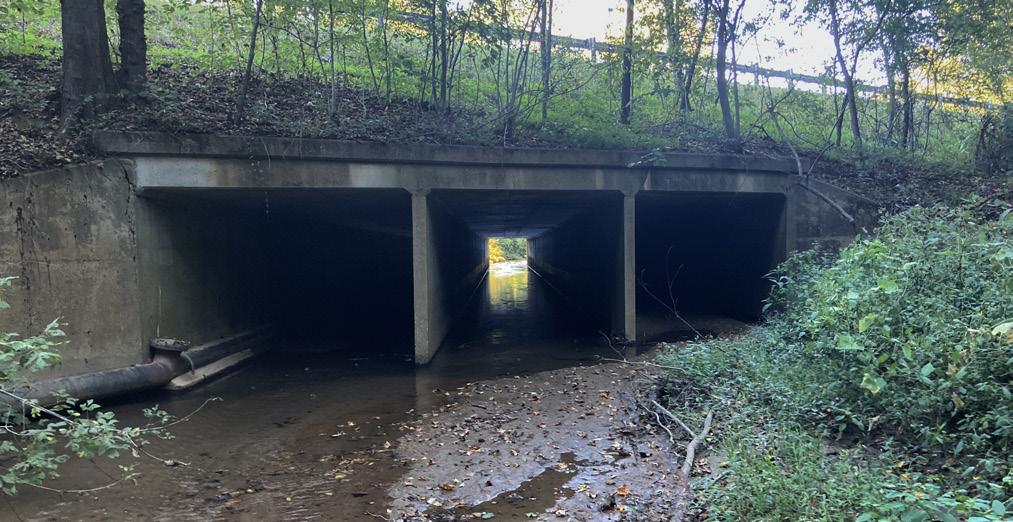
EXHIBIT 05: BOX CULVERT UNDER INTERSTATE 40
An existing box culvert that guides Hunting Creek underneath Interstate 40 will also allow for the greenway. The easternmost culvert opening will accommodate the greenway alignment.

Existing Conditions

30

4.2 TRAIL TYPES
Two trail types are proposed for the Hunting Creek Greenway and two trail types are proposed for connecting trails located in the study area. A specific trail type is proposed according to its location, surrounding environment and the opportunity to create a unique and meaningful user experience.
Typical Greenway
The typical greenway is a 10 foot wide multiuse asphalt path with a 2 foot wide shoulder on each side. This trail segment will serve as a transition segment between the intersection of College Street and Fleming Drive and Coal Chute Road.


Rural Greenway
The rural greenway is a 8-10 foot wide multiuse crushed fines path with a 2 foot wide shoulder on each side. Ideally, this trail type will provide a firm and stable surface for ADA accessibility. This is the primary trail type for the Hunting Creek Greenway.
32 2’ SHOULDER 2’ SHOULDER 3:1 MAX SLOPE 3:1 MAX SLOPE
MAX SLOPE SHOULDER 3:1 MAX SLOPE 3:1 MAX SLOPE 2’ SHOULDER 2’ SHOULDER 10’ CONCRETE
10’ ASPHALT
2’ SHOULDER 2’ SHOULDER 3:1 MAX SLOPE 3:1 MAX SLOPE 3:1 MAX
3:1 MAX
2’ SHOULDER 2’ SHOULDER 3:1 MAX SLOPE 2’ SHOULDER 10’ ASPHALT
8’
3:1
GREENWAY
GREENWAY
SLOPE
SLOPE
GREENWAY
- 10’ CRUSHER FINES GREENWAY
Crushed Stone
The crushed stone trail type is a 6 foot wide trail with a crushed gravel surface. Crushed stone trails will connect the greenway and natural surface trails.


Natural Surface
The natural surface trail type is a 4 foot wide soil path. This trail type is constructed utilizing a full bench cut to maximize the long-term environmental sustainability of the trail.
33 6’ CRUSHER FINES PATH 4’ NATURAL SURFACE PATH 10’ BOARDWALK
4.3 HUNTING CREEK PARK MASTER PLAN
Hunting Creek Park is centrally located on the site. The site currently serves as the Western Piedmont Community College Emergency Training Facility and encompasses approximately 17 acres. Once developed, the park will serve as the primary access for the Hunting Creek Greenway.
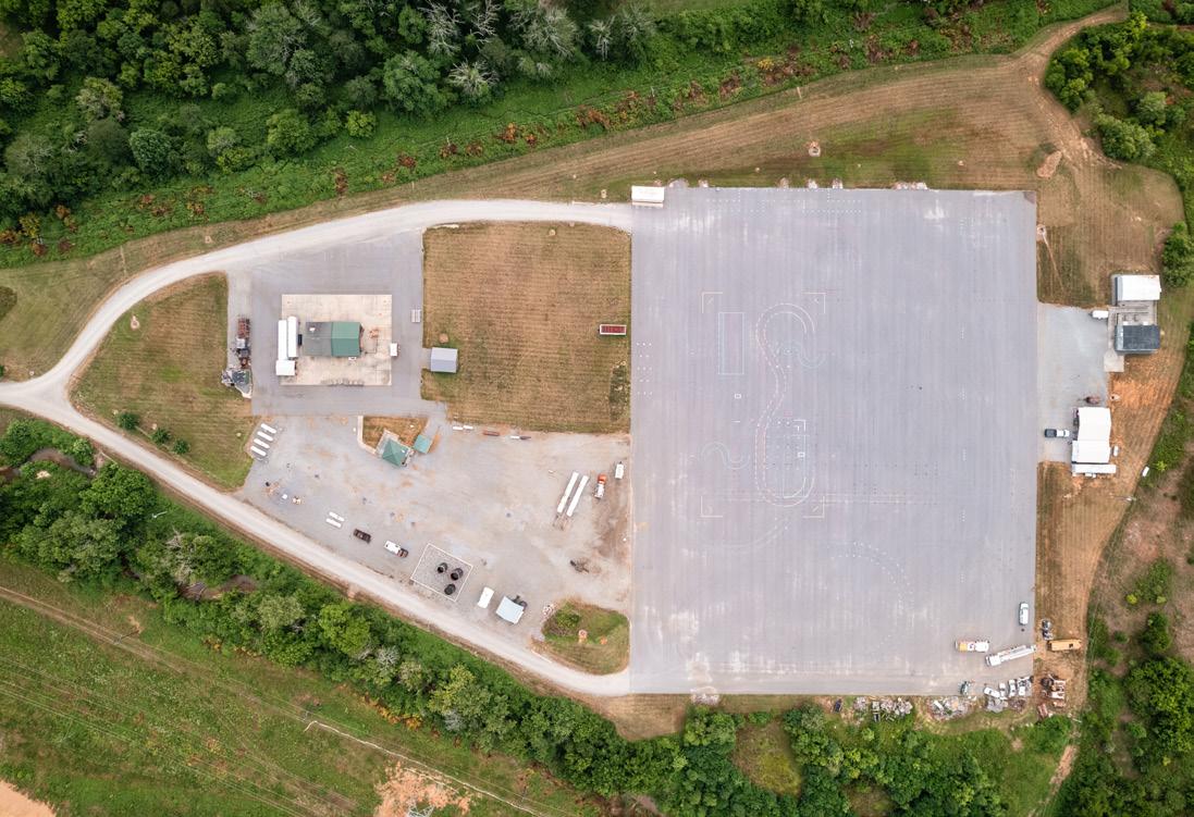
Key park elements include an open green, bouldering wall, mountain bike skills park, market pavilion, event lawn and stage, and a stormwater wetland featuring boardwalks and viewing platforms.
Supporting park elements include a playground, public art, restroom and storage building, walking path, expanded creek buffer, entrance sign, gateway to existing mountain bike trails, and parking.

ENTRANCE SIGN COAL CHUTE ROAD
34
EXPANDEDCREEKBUFFER
Existing Conditions
PARKING (84) BUFFER OVERLOOK STORMWATER WETLAND GATEWAY OPEN GREEN OVERFLOW PARKING (~75) EVENT LAWN OVERFLOWPARKING(~60) BOULDERING WALL PLAYGROUND BOARDWALK PICNIC SHELTER STAGE BRIDGE RESTROOM PUBLIC ART MTN BIKE SKILLS PARK STORAGE CORPORATE / MARKET PAVILION LEGEND FLOODPLAIN FLOODWAY HUNTING CREEK GREENWAY TYPICAL GREENWAY RURAL GREENWAY EXHIBIT 06: HUNTING CREEK PARK MASTER PLAN
Hunting Creek Park Amenities
Concrete Greenway
The concrete greenway is a 10 foot wide multiuse concrete path. This trail type will be applied to all paths within Hunting Creek Park.
Open Green & Walking Path
An open green is located in the center of the park and is bordered by a walking path, landscaping, and parking. The area could also serve as an overflow parking area for large events. The open green could also be planted as a wildflower field if less intense maintenance is desired.
Mountain Bike Skills Park
A mountain bike skills park is located in the southeast corner of Hunting Creek Park. This area will provide riders of all abilities the opportunity to develop skills that increase proficiency with bike handling, balancing, jumping, and turning.
Bouldering Wall
A bouldering wall will safely introduce park users to rock climbing without the use of ropes, harnesses, or special equipment.
Market Pavilion
The market pavilion will provide a covered area adjacent to parking which can be used for selling goods, farmers market, food trucks, and covered eating. The pavilion can also be used as a corporate picnic shelter.
EXHIBIT 07: HUNTING CREEK PARK TRAIL TYPES
The trail types within Hunting Creek Park will serve visitors of all ages and abilities. The concrete greenway will connect amenities in the park and boardwalks will complete connections in the stormwater wetland.

36
4’ NATURAL SURFACE PATH 10’ BOARDWALK
2’ SHOULDER 2’ SHOULDER 3:1 MAX SLOPE 3:1 MAX SLOPE 3:1 MAX SLOPE 2’ SHOULDER 2’ SHOULDER 3:1 MAX SLOPE 3:1 MAX SLOPE 2’ SHOULDER 2’ SHOULDER 10’ CONCRETE GREENWAY 10’ ASPHALT GREENWAY 8’ - 10’ CRUSHER FINES GREENWAY
Event Lawn and Stage
An open event lawn and stage is located at the south end of the park. It is bordered on the south end by a stage and north end by a corporate/market pavilion. The area can also be utilized as an open green when events aren’t occurring.
Stormwater Wetland with Boardwalk
A wetland/stormwater bioretention area is located in the southwest corner of the park adjacent to Hunting Creek. This wetland will store stormwater from the park and surrounding area while providing an educational feature at the park. A boardwalk with overlooks will allow park visitors to meander throughout the wetland and create an educational feature. In addition, an expanded creek buffer that stretches from the wetland north will provide more protection to the water quality in Hunting Creek.


Picnic Shelters

Six small to medium sized picnic shelters are located on the north side of the primary parking area and the southern end of the open green/wildflower field. These shelters will serve families and organizations of different sizes and provide a number of central gathering spaces.


Playground
Bouldering Wall
Mountain Bike Skills Park Stage Picnic Shelter
Restroom
HUNTING
EXHIBIT 08:
CREEK PARK PRECEDENT IMAGES


5 The Hunting Creek Greenway presents an ambitious project that will have a positive impact on the economy and quality of life for local residents and visitors. Due to its connection to the downtown area and other multi-use pathways and parks within Morganton, the project will not only expand recreational opportunities in the City, but it will also support economic growth by creating a significant community and tourism asset. IMPLEMENTATION 5.1 General Implementation Recommendations 5.2 Physical Needs Summary and Estimate of Probable Costs
The Project Oversight Committee (POC) should continue to work together on implementation, management, and maintenance of the greenway and park. A variety of grant sources should be explored to help fund the project.
Hunting Creek Greenway and Park Management
The POC should remain intact and guide implementation and management of the Hunting Creek Greenway and Park. Initially, the Hunting Creek corridor should be placed under the ownership/management of one governmental agency to provide for site control, which is a requirement for most grants. In addition, placing a conservation easement on the corridor and park site will provide permanent protection and could potentially provide project funding if acquired with grant funding. An interlocal agreement between the project partners will address implementation, management, and maintenance of the greenway and park.
Grant Procurement Strategy
Many state and federal grants have an environmental, recreation, or health and wellness focus. The existing degraded condition of Hunting Creek and the variety of recreational opportunities along the greenway and within the park may increase the number of grants available for the project. Environmental grants that aren’t typically associated with recreational development can often be leveraged with grants for parks and greenways and create a source of matching funds. See Exhibit 09:Potential Grant Funding Sources below.
This plan was prepared in accordance with the NC Parks and Recreation Trust Fund (PARTF) standards. This grant source should anchor any grant procurement strategy developed by the proposed managing organization. The NC Water Resources Development Grant provides funding for stream restoration, water management, and water-based recreation sites such as greenways. This grant should also be pursued as a possible funding source for all elements of the project.
40
GENERAL IMPLEMENTATION RECOMMENDATIONS EXHIBIT 09: POTENTIAL GRANT FUNDING SOURCES PARTNERSHIP FUNDING AGENCY Parks and Recreation Trust Fund (PARTF) IMPLICATIONS MAX. AMOUNT MATCHING FUNDS DEADLINE All types of parks, trails, and recreation facilities $500,000 50% Early May Recreational Trails Program (RTP) All types of trails, greenways, and paddle access areas $100,000 25% Early August Water Resources Development Grant Program Greenways, boardwalks, and water access areas Varies 50% Late Dec/June People for Bikes Community Grant Bike Trails and Greenways $10,000 50% Spring/Fall NC Land and Water Fund Formerly Clean Water management Trust Fund (CWMTF) Stream restoration, enhancement, or stabilization Varies Varies Early February
5.1

42
5.2 PHYSICAL NEEDS SUMMARY & ESTIMATE OF PROBABLE COSTS EXHIBIT 10: HUNTING CREEK GREENWAY AND TRAILS ITEM Greenway and Trail Development QUANTITY UNIT UNIT COST TOTAL COST Hunting Creek Greenway - Asphalt 2,089 Linear Feet $150 $313,350 Hunting Creek Greenway - Gravel Fines 8,498 Linear Feet $80 $679,840 Hunting Creek Bridge 1 Lump Sum $300,000 $300,000 Connecting Trails 26,813 Linear Feet $30 $804,390 Minor Bridges Lump Sum $150,000 $150,000 Subtotal $2,247,580 Contractor Overhead and Contingency Mobilization, Site Supervision, and Bonds (5%) $112,379 Contingency (10%) $224,758 Subtotal $337,137 Soft Costs Engineering and Permitting (18%) $465,249 Contract Administration (3%) $77,542 Subtotal $542,791 Grand Total $3,127,508
The purpose of this section is to establish a summary of physical needs and estimate of probable costs. The physical needs include the recreational infrastructure elements of the greenway and park. The estimates of probable costs have been separated between the greenway and trails and Hunting Creek Park to allow for phased implementation.
43 EXHIBIT 11: HUNTING CREEK PARK ITEM Site Work and Park Development QUANTITY UNIT UNIT COST TOTAL COST Demolition, Site Prep, and Grading 1 Lump Sum $250,000
Curb and Gutter 2,846 Linear Feet $30
Bouldering Wall 1 Lump Sum $250,000
Bridge to Greenway 1 Lump Sum
Stage 1 Lump Sum $250,000
Subtotal $4,190,986 Contractor Overhead and Contingency Mobilization, Site Supervision, and Bonds (5%) $209,549 Contingency (10%) $419,099 Subtotal $628,648 Soft Costs Engineering and Permitting (18%) $867,534 Contract Administration (3%) $144,589 Subtotal $1,012,123 Grand Total $5,831,757 Stormwater and Drainage 1 Lump Sum $150,000 $150,000 Sidewalks 30,447 Square Feet $13 $395,811 Restroom 1 Lump Sum $250,000
Mountain Bike Skills Park 1 Lump Sum $150,000
Playground 1 Lump Sum
Utilities 1 Lump Sum $75,000
Boardwalk 600 Square Feet
Storage Building 1 Lump Sum $100,000
Medium Picnic Shelter 3 Lump Sum
Signage 1 Each $50,000
Asphalt Parking Lot 4,137 Square Feet $35 $144,795 20' X 95' Market Pavilion 1 Lump Sum $300,000
Stormwater Wetlands 1 Lump Sum
Small Picnic Shelter 4 Each
Landscape 1 Lump Sum $150,000 $150,000
$250,000
$85,380
$250,000
$250,000 $250,000
$250,000
$250,000
$150,000
$200,000 $200,000
$75,000
$150 $90,000
$100,000
$150,000 $450,000
$50,000
$300,000
$300,000 $300,000
$75,000 $300,000


A APPENDIX 01 NRCS Soils Map 02 Public Engagement Meeting Comments 03 Hunting Creek Stream Restoration and Enhancement Plan 04 Duke Energy Shared Use Path/ Trails Requirements 05 NCSHP0 Project Review Response

46 APPENDIX 01: NCRS SOILS MAP

47
HUNTING CREEK GREENWAY COMMUNITY ENGAGEMENT DROP-IN MEETING
Thursday, August 4, 2022, at 5:30-7 PM NC School of Science and Math Morganton Campus - Goodwin Hall
● A butterfly trail to involve the community
● This is a great idea and great use of resources. It would be great if the greenway was natural surface like at Valdese Lakeside Park. Also, would like to see the mtb trail above the greenway restored.
● Skate park
● Playground
● Mtn bike paths
● Away from pedestrians
● Hunting Creek is used in classes and research at WPCC. Access to creek is important.
● Bike Repair Stations
● Suggestion for the fire training reuse and overall land use. Not great space for real mountain bike trails - too many fields and spread out. Instead use the space/land for trails more like Moses Cone or Biltmore. Great paths for multiuse bike/run/walk. We need more rec space.
● With limited time studying the map, a lot of this greenway could use old/under used service roads/path on the campus. I suppose it would connect to the current trails already in place?
● Glad you are including JIRDC. Does that mean it will be wheelchair accessible? Restrooms, picnic areas. Path down to water in some places. Restore trees and plants native to NC.
● At one time talking with …., I had seen a proposal done under the McCrory administration. That a pond was to go in where the Burke County Emergency Training Facility. Sediment load that comes down Hunting Creek, a pond would have to be cleaned out every 6-8 months.
● Existing cost-share contract with State of NC - Division of Soil and Water and Burke Soil and Water has a 10 year maintenance agreement stream stabilization project.
48 APPENDIX
02: PUBLIC ENGAGEMENT COMMENTS
HUNTING CREEK GREENWAY COMMUNITY ENGAGEMENT DROP-IN MEETING
Thursday, October 27, 2022, at 5:30-7 PM NC School for the Deaf Main Building Auditorium
● Love the open green space at the park
● So thankful and excited for this - Those service roads regularly get foot traffic in the walking and jogging classes … at WPCC
● Take care, if possible, of the culverted Hunting Creek area between S. College Street and South Sterling Street as part of the stream restoration. Also, get additional parking from the Roses parking lot.
● Show connection to new apartments.
● Who takes care of all of this?
● I don’t think all of these park amenities are needed, just open lawn and parking with restroom and shelters.
● Seems like storm pond area is at opposite end from drainage should be near entrance?
● Show pedestrian crossing concept @ Fleming
● Show cross section of trail adjacent to Fleming @ or below road grade?
● Playground and activity uses too far from Coal Chute Road
● Show historic amenity of the actual coal chute w/signs and renovation, include in plan
● Remove shooting range at WPCC
● Show rendering of bridge crossing/what elevation over creek will it be, what type of bridge recommended
● Show Coal Chute upgrades and gateway to park @ Fleming
● Need light @ Coal Chute for working in area to cross Fleming @ lunch break
● Bridge crosses at intersection of two drainages currently or is this after they converge
● Make road and parking pervious
49


50
greenway revisions
to interference with stream
Wildlands
greenway revisions due to interference with stream 9/23/2022 gdecarvalho Map 5 - Conceptual Greenway Exhibit Hunting Creek Restoration Site Catawba River Basin (03050101) ¹ 0 500 1,000 Feet Burke County, NC Path: Z:\Projects\NC\W16901_MorgantonHuntingCreek\PRO_HuntingCreek\PRO_HuntingCreekRestoration.aprx 2020 Aerial Imagery *Final greenway design and composition to be determined by Destination by Design Proposed Greenway (Destination by Design) Proposed Greenway Revison (Wildlands) Proposed Stream Enhancement Proposed Stream Restoration APPENDIX 03: HUNTING CREEK STREAM RESTORATION & ENHANCEMENT PLAN
Wildlands proposed
due
re-alignment
proposed
Electric Transmission Right of Way Requirements for Shared-Use Paths/Trails
This list of Duke Energy’s transmission right of way requirements for the co-location of shared-use paths/trails has been developed as a guideline to answer the most frequently asked questions. This should not be considered a comprehensive list of all requirements or factors that may need to be addressed. You should contact the Asset Protection Right of Way Specialist if you have additional questions or concerns. This list of requirements and guidelines is subject to change at any time and without notice. Duke Energy reser ves all rights conveyed to it by the right of way agreement applicable to the subject proper t y An engineering drawing, including topographic grade changes, location of Duke Energy structures and paths/trails must be approved by an Asset Protection Specialist.
Compliance with these Duke Energy Shared-Use Path/Trails requirements, or approval of any such plans by Duke Energy, does not guarantee that other applicable requirements imposed by any local, count y, state, federal or other applicable regulator y agency have been satisfied.
Definition: For purposes of this document the term “trail(s)” shall be used to refer to Multi-Use Paths or Shared-Use Paths as defined by the American Association of State Highway and Transpor tation Officials (AASHTO).
1. The trails must not exceed a total of 12 feet in width, regardless of the sur face construction material.
2. A minimum separation of 25 feet is required between the trail and its associated easement, to any Duke Energy electrical facilit y This includes, but is not limited to, poles, towers, guy anchor(s), equipment, etc. If the owner of the trail is not the current owner of the fee simple title to the lands underlying Duke Energy’s easement, the trail owner shall obtain a legally sufficient easement from the current fee simple title owner and produce said easement to Duke Energy prior to commencing activities within the Duke Energy easement. In the event a private easement is not required, no por tion of the trail or shoulder, or associated grading, shall be located within 25 feet of any electrical facilit y.
3. The owner of the trail shall be responsible for safety and liability associated with its construction or use thereof
4. Bollards shall be installed per Duke Energy specifications, with Duke Energy locks, where the trailheads connect with roads/ streets as to prevent vehicular traffic. Duke Energy may require reinforcement of the trail at specified access points along the corridor for Duke Energy heavy equipment crossings. These trail reinforcement areas shall consist of a 20-foot-long, 12-footwide paved area capable of supporting 80,000 pounds with pavement markings indicating “heavy equipment crossing.”
5. Culver ts shall be installed where the trails cross creeks, ditches, etc. These culver ts shall be capable of supporting 80,000 pounds, and shall be a minimum of 20 feet wide. Signage must indicate the maximum load of the crossing at culver t approach.
6. No structures including, but not limited to, lights, signs, benches, exercise equipment, and irrigation systems shall be located within the Duke Energy easement.
7. Planting of vegetation shall adhere to the Right of Way (RW) Restrictions Guidelines for the specific Duke Energy territor y. A copy of the RW Restrictions/Guidelines can be obtained from your Asset Protection Specialist.
8. Duke Energy reser ves the right to close, without notice, all or a por tion of the trail located within the transmission line easement, for any length of time, for construction, maintenance or emergency line operations.
9. Duke Energy will not be held responsible for any damages to the trails due to its operations or any liability based on the use of the trail. Prior to the installation of a shared-use trail, a “Trail Encroachment Agreement”, which includes “hold harmless” language, shall be executed with Duke Energy In addition, deed information of all proper ty owners that the trail affects must be supplied to Duke Energy Proof that the proper ty owners have signed an easement agreement with the owner of the trail will be required, as applicable.
10. All other Duke Energy electric transmission right of way restrictions/guidelines shall apply to the installation of trails.
We hope this is useful information If you have additional questions or plan any activity not mentioned above, please contact:
Form #XXXXXX (Rev. 05/19/2014) 51 APPENDIX 04: DUKE ENERGY SHARED USE PATHS/TRAILS
Duke Energy Representative Phone Number
REQUIREMENTS
Placeholder
52 APPENDIX 05: NC SHPO PROJECT REVIEW RESPONSE
Placeholder
53
