
Produced For:

Produced By:

CONTENTS 1 2 3 Introduction & Background 1.1 Background ................... 10 1.2 Goals ................................ 11 1.3 Planning Process ........ 12 Site Analysis & Design Determinants 2.1 Study Area Context . 16 2.2 Previous Plans ........... 20 2.3 Environmental Conditions ................... 22 2.4 Opportunities & Constraints .................. 26 Public Engagement 3.1 Community Surveys ......................... 32 3.2 Public Engagement & Input .......................... 34
Acknowledgments: Project Oversight Committee
Carol Price, McDowell County TDA
Bob Boyette, City of Marion
Heather Cotton, City of Marion/Friends of the MST
Ginger Webb, West Marion Community Forum
Steve Pierce, McDowell Trails Association
Debora Workman, Marion East Community Forum
Billy Martin, City of Marion/West Morehead Cemetery
Vance McNees, City of Marion
Pat Cook, Marion East Community Forum
Oscar Creech, McDowell Trails Association
4 5
Recommendations 4.1 General Rail Trail Recommendations ... 38 4.2 Specific Site Recommendations ... 42 Implementation 5.1 General Implementation Recommendations ... 74 5.2 Physical Needs Summary & Estimate of Probable Costs ..... 76 5.3 Funding Opportunities ............. 78 Appendix A: Phase I Environmental Assessment Executive Summary...................... 82 B: NRCS Soil Map ........... 85 C: Public Engagement Meeting Comments 88 D: Peavine Trail Trestle Feasibility Study ....... 89 E: Corridor Deed .......... 107
A
Maps: Map 01: Study Area Context ...................................... 16 Map 02: Regional Trail Network................................ 17 Map 03: Marion Peavine Trail 19 Map 04: Marion Peavine Rail Trail Study Area ... 39 Map 05: Recommendations - Section 1 ................ 43 Map 06: Peavine Cemetery Connections ............. 53 Map 07: Recommendations - Section 2................. 61 Map 08: Passive Park & Mixed-use Redevelopment Opportunities ............... 67
Exhibits: Exhibit 01: Oak Grove & Morehead Cemeteries .... 25 Exhibit 02: Peavine Rail Trail Branding & Signage 38 Exhibit 03: Peavine Trail Type Cross-Section ....... 40 Exhibit 04: Peavine Rail Trail Road Crossings........ 41 Exhibit 05: State Street Trail Entrance..................... 45 Exhibit 06: Alabama & Virginia Avenues Trail Crossings ............................................. 47 Exhibit 07: Georgia Avenue/Morehead Road Trail Crossing ................................... 50 Exhibit 08: Georgia Avenue/Morehead Road Rendering .......................................... 51 Exhibit 09: Baldwin Avenue Crossing ...................... 56 Exhibit 10: Baldwin Avenue Rendering .................... 57 Exhibit 11: Marion Street Crossing 59 Exhibit 12: First Christian Church Trailhead & Rail Trail ..................................................... 63 Exhibit 13: Peavine Trail Trestles Feasibility Study .............................................................. 65 Exhibit 14: Trails & Mixed Use Developments ....... 68 Exhibit 15: Project Summary Matrix .......................... 77 Exhibit 16: Grant Funding Opportunities Matrix ............................................................. 79

INTRODUCTION & BACKGROUND
1.1 Background
1.2 Goals
1.3 Planning Process
The Marion Peavine Rail Trail Master Plan presents a detailed master plan for the improvement and extension of the trail from State Street to Jacktown Road in Marion, North Carolina. This chapter provides a brief project background and outlines the project goals and planning process.


1
1.1 BACKGROUND
In 2010, the City of Marion purchased a 2.4 mile long, 100-foot-wide former railroad corridor from Norfolk Southern Corporation with the vision to create a 10-foot-wide shared use trail between downtown Marion and McDowell Technical Community College. At that time, the City constructed 1.5 miles of crushed gravel and grass trail running from State Street in downtown Marion to Ford Way.
The long-range vision, as outlined in the Peavine to Thermal Belt Rail Trail Connector Feasibility Study from 2020, is to create a 30 mile regional trail that connects Marion to Rutherfordton, North Carolina, and the existing trail system there. The Peavine Trail has also been adopted by the N.C. Department of Transportation as part of the Great Trails State Plan, a statewide plan with the goal of connecting all 100 counties via shared use path or trail.
The Destination McDowell Tourism Master Plan completed in 2021 identified the Peavine Trail as a high-priority project. The plan provides recommendations for a Peavine Trail brand to be incorporated into quality signage and surface treatments along the length of the existing trail. Destination McDowell also presents renderings and site plans of street crossing enhancements for the trail.
The City of Marion plans to improve the Peavine Rail Trail to make it a more attractive asset for community members and visitors. Improvements to the trail will create a more accessible and appealing experience for walkers, runners, and cyclists, which may spark private investment in commercial and residential development along the trail corridor.
The vision for the Marion Peavine Trail includes welcoming trailheads with adequate parking, wayfinding signage, information kiosks, benches, safe pedestrian crossings and eventually the extension of the trail to McDowell Technical Community College.
10 Introduction & Background
The 2020 Destination McDowell
Tourism Master Plan identified
“”
the Peavine Trail as a highpriority project.
1.2 GOALS
PROVIDE ACCESS & CONNECTIVITY
Provide safe access and connectivity for pedestrians and cyclists between downtown Marion, residential neighborhoods, and McDowell Technical Community College.
PROMOTE HEALTH & WELLNESS
Enhance quality of life for current and future residents and visitors through outdoor recreation infrastructure that promotes opportunities for physical, mental, and social wellness.
CREATE IDENTITY
Strengthen the appeal of the Marion Peavine Rail Trail as a valuable community asset by providing a unique brand that distinguishes it from other trails and greenways in the area.
SUPPORT COMMUNITY GOALS
Support community goals to improve the health of residents, attract visitors, foster entrepreneurship, and preserve the sense of community that is unique to Marion.
POISED FOR GRANT FUNDING
Ensure grant competitiveness by adhering to planning guidelines required by the North Carolina Parks and Recreation Trust Fund (PARTF) and other grant funding sources.
11 Introduction & Background
1.3 PLANNING PROCESS
PHASE 1 // PROJECT LAUNCH
OCTOBER 2022
» Develop Working Maps
» Kick-off Meeting
PHASE 2 // RESEARCH
& ANALYSIS
OCTOBER-NOVEMBER 2022
» Previous Plan Review
» Existing Conditions Inventory
» Site Analysis and Field Visit

12 Introduction & Background
PHASE 3 // COMMUNITY ENGAGEMENT
DECEMBER 2022
PHASE 4 //
DRAFT PLAN DEVELOPMENT
DECEMBER 2022-JANUARY 2023
PHASE 5 //
FINAL PLAN DEVELOPMENT
JANUARY 2023
» Stakeholder Meeting
» Public Meeting
» Draft Trail Master Plan
» Develop Renderings and Schematics
» Estimate of Probable Costs
» Finalize Trail Master Plan
» Adoption by City Council

13 Introduction & Background
2 SITE ANALYSIS & DESIGN DETERMINANTS
2.1 Study Area Context
2.2 Previous Plans

2.3 Environmental Conditions
2.4 Opportunities and Constraints
This section provides an overview of existing conditions along the Peavine Trail corridor. The chapter begins by examining the context of the project area and reviewing past planning efforts. Next, it highlights features of the natural and built environment that may have implications on the trail improvements and extension. Finally, the chapter presents opportunities and constraints found along the trail corridor.
2.1 STUDY AREA CONTEXT
The study area is located in the foothills of western North Carolina within the City of Marion, which lies in close proximity to Interstate 40 in McDowell County. US Highway 221 bisects the County and runs north to south connecting the Blue Ridge Mountains to the Foothills. Asheville, Spruce Pine, Morganton, and Rutherfordton are all within a half-hour drive. The city is surrounded by natural and recreational assets like Pisgah National Forest, Chimney Rock State Park, Blue Ridge Parkway, Lake James State Park, and South Mountains State Park and Game Lands (See Map 1: Study Area Context).

REGIONAL TRAIL NETWORK
The Mountains-to-Sea Trail, Overmountain Victory National Historic and State Trail, Fonta Flora State Trail, and the Wilderness Gateway State Trail all travel through McDowell County. The Fonta Flora State Trail is planned to pass through downtown Marion on its way to Asheville and Morganton. The Upper Catawba River Paddle Trail connects Marion with communities along the Catawba River via an existing blueway. The planned Peavine to Thermal Belt Rail Trail Connector will provide a north to south connection to the Main Street region of neighboring Rutherford County. This growing regional trail network will connect Marion to assets in western North Carolina and statewide (See Map 2: Regional Trail Network, page right).
16 Site Analysis & Design Determinants
Map 01 : Study Area Context

Map 02 : Regional Trail Network
MARION PEAVINE TRAIL
The existing Marion Peavine Trail begins at City Stage on North Main Street in downtown Marion. It travels south along sidewalks approximately 0.2 miles to the intersection of South Main Street and State Street then turns east. The trail route follows the sidewalk on the north side of State Street approximately 0.25 miles to the beginning of the rail trail corridor.
The existing rail trail stretches 1.5 miles to Ford Way, just south of First Christian Church on Rutherford Road. A short section stretches approximately 0.2 miles further south before ending at a gate across the trail at an abandoned trestle. The rail corridor continues south parallel to Rutherford Road before ending at Jacktown Road. This section of the corridor above represents the study area for this planning effort.
At Jacktown Road the corridor rejoins an active CSX Transportation railroad line. Future plans to extend the Peavine Trail to McDowell Technical Community College will require the trail alignment to travel south across US Highway 226 and through an existing culvert under Interstate 40 (See Map 3: Marion Peavine Trail, page right).
18
HZion ill Dr CoolSpringLn CrawfordTer Cross St C o p per Pot D r Ruth Dr Willoughby Way Pine St Snow BrookeDr MeredithLn AtwoodDr Carriage Sta GreenleeSt BigDipperDr Wdoo C h u c k Ln WZebVanceSt Hunt St Cool SpringRd Joes Dr D a r e D r Shop Dr EdCannonDr S t at e Rd 1811 SCrestLn Tennessee Ave 5th Em St State Rd 1827 DSleeping oveD r 4th Em St CopelandDr Gable Dr EuclidAve Pine Grove St 2nd Em St CrawfordSt S tat e Rd1729 T e a l St Georgia Ave 1stEm St Bostic St Southview Ct E Ya nce y St W CourtSt 3rd Em St Sinc la i r evA V a l e S t Bo b s ImportDr RidgecrestDr ScottDr 6th E m S t N Garden St Leach St ClaySt Alabama Ave Lincoln Ave Three Point dR Virg inia Ave Christop dRher KidsWay Willow St Ridge S t SMcDowell A v e rotcorP KnobRd BarnesHillRd N Mai n St Robin Dr Nature Dr RailroadSt Parkers Ch a pel Rd PoteatRd StateRd1811 Fairview Rd Beulah LandDr Mountain CrestDr S Logan St GlenwoodAve Fairview Rd Robert a S t Forest H e ig h t Ds r MorganSt GoforthRd WildwoodTer BroadSt HunterDr PisgahViewDr Hol l y Hill D r hC a lep iH l l Chu rc h Loop Perry St Marion S t Californi a A v e Spring St S Mai n St WoodChuckLn WHendersonSt Gaddy RdW S Gard en S t E Glenview St ECourtSt College Dr Foxwood Dr State Rd1734 Fairview Rd Cooper Rd MoreheadRd StateSt Snow BrookeDr MountainCrestDrS tvP StateRd1741 N M ai n S t USHwy221 B a l d w i n A v e Sta te Rd1703 Moodytown Rd State Rd1733 Woodchuck Ln Mountain CrestDrSP v t Owl Hollow Rd HeavenheightsLn GrantsMountain Rd I-40 Jacktown Rd I40 RutherfordRd USHwy221 Byp USHwy 221Bus StateHwy226 Marion Mcdowell technical community college First christian church City Stage 221 40 40 226 70 0 1 0 . 5 Miles Existing Peavine Trail Planned Peavine Trail N Map 03 : Marion Peavine Trail
2.2 PREVIOUS PLANS
The consultant team reviewed transportation, tourism, greenway, and parks and recreation planning documents that might have implications on the Marion Peavine Trail alignment, improvements, and desired trail amenities.

GREAT TRAILS STATE FINAL REPORT (2022)

The Peavine Trail has been adopted by the N.C. Department of Transportation as part of the Great Trails State Plan, a statewide plan with the goal of connecting all 100 counties across the state via shared use path or trail to create opportunities for active transportation, conservation, recreation, health, tourism and economic prosperity.
THE PEAVINE TO THERMAL BELT RAIL TRAIL CONNECTOR FEASIBILITY STUDY (2020)
This feasibility study from 2020 examines the potential health, recreation, and economic benefits of establishing a multi-use public trail along an abandoned railroad corridor. This proposed 19-mile long trail will connect the Peavine Trail in Marion to the Thermal Belt Rail Trail in Rutherford County.

NORTH MAIN STREET CORRIDOR STRATEGY REPORT (2020)

The North Main Street Corridor Plan was produced in 2020 and proposes significant upgrades to a two-mile section of US70/221 in Marion. A four-lane divided boulevard and major gateway features at each end of the corridor have been proposed. The plan provides further connectivity through downtown Marion to the Peavine Rail Trail and the proposed Fonta Flora State Trail.
DESTINATION MCDOWELL TOURISM MASTER PLAN (2021)

This Tourism Master Plan was created in 2021 and provides a 15-year infrastructure development plan for the McDowell County TDA and its partners. Corridor redevelopment and trail improvements along the Peavine Trail were identified as a high-priority project to provide access to recreational opportunities within the city limits and provide connections to longer regional and state trails.
PEAVINE TRAIL TRESTLES FEASIBILITY STUDY (2019)
The Peavine Trail Trestles Feasibility Study was conducted in 2019 to assess the viability of extending the Peavine Trail to the southeast along the existing abandoned railroad corridor. The study evaluated the two railroad trestles in this section for possible conversion into pedestrian bridges.
20 Site Analysis & Design Determinants
ISOTHERMAL REGIONAL BICYCLE PLAN (2018)
The Isothermal Regional Bicycle Plan was prepared for the Isothermal Planning and Development Commission in 2018. The plan recognizes regional partnerships and the importance of creating an extensive network of bicycle routes and options attractive to tourists and local users alike. The Peavine Trail extension is listed as a top priority project in this plan.


MCDOWELL COUNTY COMPREHENSIVE PARKS AND RECREATION MASTER PLAN (2014)
The McDowell County Comprehensive Parks and Recreation Master Plan from 2014 addresses the parks and recreation needs for the County. This was accomplished through extensive public input and a complete assessment of existing facilities. The plan documents that trails and greenways received tremendous public support during the planning process with nearly 100% of the survey participants in favor of expanding existing greenways in the County.


CITY OF MARION: PARKS AND RECREATION MASTER PLAN (2016)

The City of Marion Parks and Recreation Master Plan considers many aspects of both passive and active recreation. The plan provides an evaluation and inventory of existing facilities and describes public involvement and the planning process. The plan notes that residents would like the Peavine Trail to extend to McDowell Technical Community College and would also like to see the old railroad trestles restored for bike and pedestrian use.
CITY OF MARION COMPREHENSIVE BICYCLE PLAN (2016)
The City of Marion adopted a Comprehensive Bicycle Plan in 2016. The plan was a part of the NCDOT Bicycle and Pedestrian Planning Grant Initiative program, which places a strong emphasis on traffic safety and the economic benefits of active transportation. Various improvements to the City’s street network are suggested including improved linkages between local destinations such as the Peavine Trail and the Catawba River Greenway. The Peavine is identified as a priority investment recommendation in the plan.
MCDOWELL COUNTY COMPREHENSIVE TRANSPORTATION PLAN (2013)
The McDowell County Comprehensive Transportation Plan (CTP) is a multi-modal plan that examines the County’s long-range transportation needs. The CTP was based on the projected growth for the planning area which only included the County.
MCDOWELL COUNTY GREENWAYS MASTER PLAN (2007)
The McDowell County Greenway Master Plan was adopted by the McDowell County Commissioners in 2007 and lays out the vision of the McDowell Trails Association (MTA), a non-profit organization created for the purpose of establishing an extensive trail system in the County. The plan identifies existing and planned trail sections as well as possible future alignments and connections.

21 Site Analysis & Design Determinants
2.3 ENVIRONMENTAL CONDITIONS
This section highlights site analysis findings pertaining to the natural and built environment, including those related to topography, soils, vegetation, land use, and roads. A detailed Phase I Environmental Site Assessment (ESA) of the corridor was conducted in 2011. See Summary in Appendix A: Phase I Environmental Assessment Summary, page 82.
TOPOGRAPHY
The study area corridor is 2.4 miles long, 100-feet-wide, and contains approximately 30 acres. Elevations range from 1400 to 1280 feet above sea level. The highest elevation is near the State Street trail entrance and the lowest elevation is located between Ford Way and Jacktown Road.
Several short sections of the corridor are elevated significantly above the surrounding terrain. This includes the southern halves of the railbed between Virginia Avenue and Georgia Avenue/Morehead Road and Georgia Avenue/Morehead Road and Baldwin Avenue. South of Ford Way the corridor also rises above the surrounding terrain as it approaches the first railroad trestle and continues to a former lumber yard accessed from Jacktown Road.
SOILS
According to the Natural Resources Conservation Service (NRCS), there are 6 different soil types found within the project corridor. The soils identified include: Braddock clay loams (BrC2 and BrD2), Hayesville-Evard complex (HeD), Hayesville-Evard-Urban land complex (HrD), Hayesville-Urban land complex (HuC), and Iotla sandy loam (IoA).
Generally speaking, the soils within the project site are a mixture of sandy clay loams. According to the NRCS soil survey reports, these soils are generally rated as being somewhat limited for path and trail development and very limited for road development due to soil characteristics. However, the Peavine Trail will utilize the existing man-made railroad bed which was constructed in the early 1900s for train use and is appropriate for trail development.
HYDROLOGY AND FLOODPLAIN
Youngs Fork runs parallel and well away from the study area corridor on the west side of Rutherford Road from its beginning at West Henderson Street before crossing underneath Rutherford Road just south of Ford Way. The creek continues south parallel to and below the railroad corridor before passing under Jacktown Road. Two small drainages and creeks flow under the corridor from the east and feed Youngs Fork. A wide floodplain exists on a vacant parcel at the confluence of Youngs Fork and the second drainage below the abandoned railroad corridor.
Site Analysis & Design Determinants
22
VEGETATION & SIGNIFICANT NATURAL COMMUNITIES
The site consists of a 100-foot-wide corridor with a manmade raised railroad bed. Scattered multi-aged mixed deciduous forests within the corridor contain a variety of tree types typical of the region including Oak, Hickory, Blackgum, Red Maple, Yellow Poplar, and Pine. There are no significant natural communities found on the site.


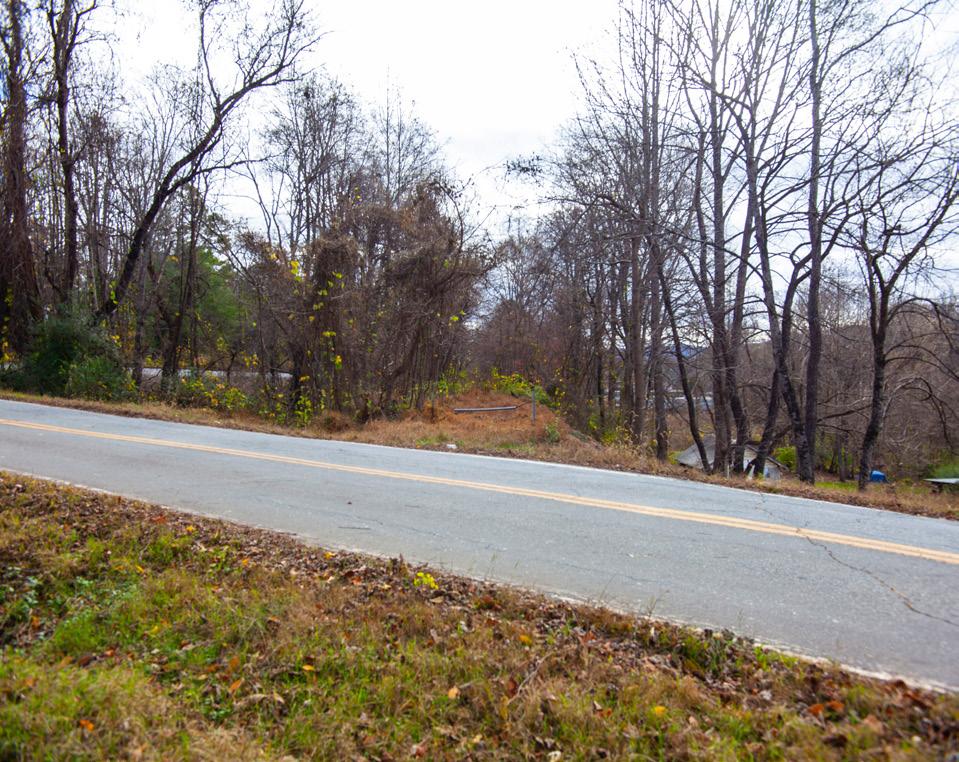
BUILT ENVIRONMENT
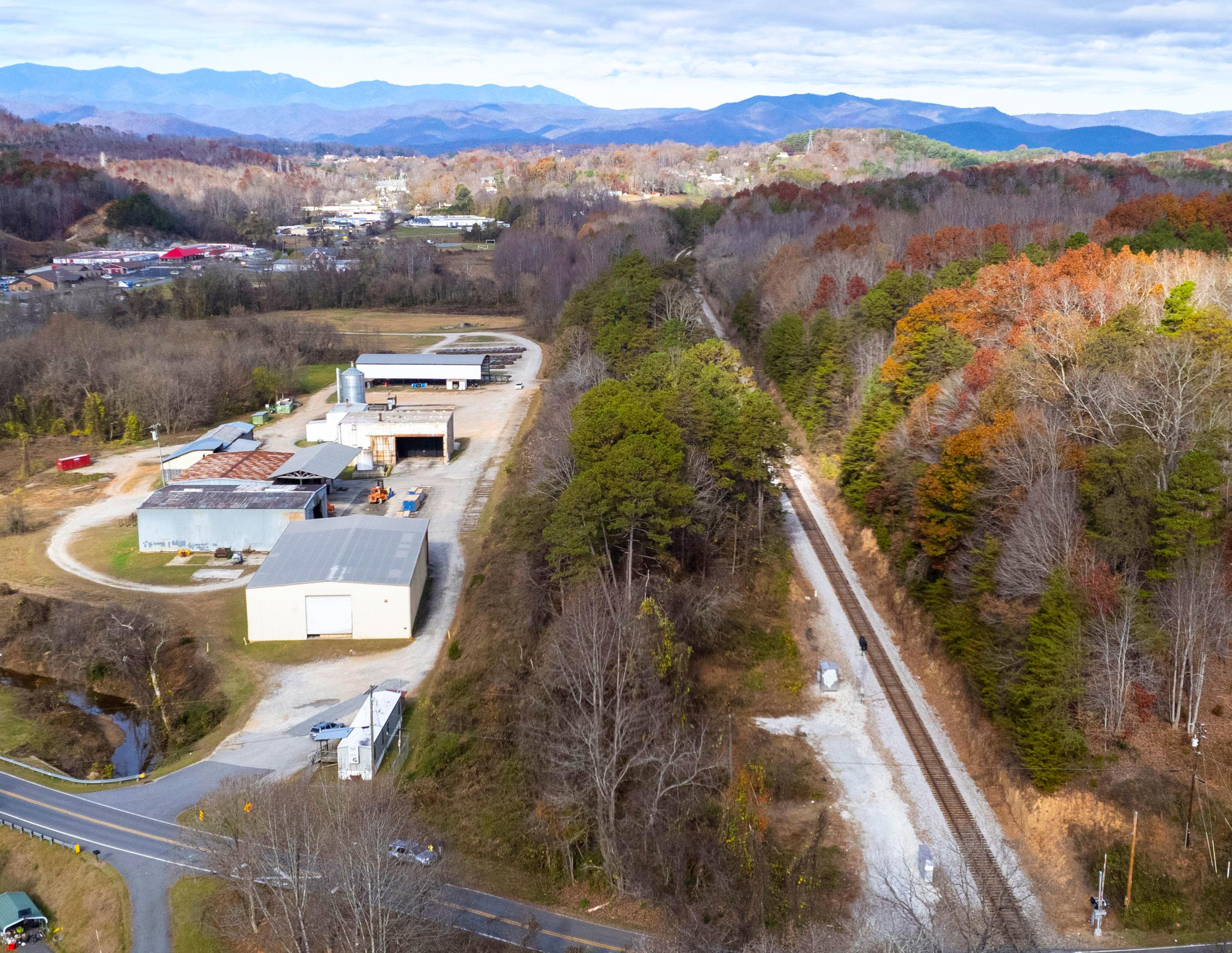
A man-made railbed exists within the study area corridor. Approximately 1.5 miles of the railbed has been cleared and surfaced with crushed gravel. In some areas, erosion has exposed rocks of various sizes. The remaining 0.9 miles of the railbed is overgrown with vegetation and the surface is a mix of grass, leaves, and soil. Two wooden railroad trestles are also located on this section.
The corridor begins at State Street and passes through and next to a mixture of residential, civic, industrial, and commercial land uses. The trail from State Street to Georgia Avenue/Morehead Road features primarily residential development. After this crossing, the large Oak Grove Cemetery is located on the west side of the corridor and the smaller Morehead Cemetery and several wooded parcels are found on the east side of the trail. A large Duke Energy substation is located next to Oak Grove Cemetery at the trail’s intersection with Baldwin Avenue. The trail then passes through a mix of residential and commercial uses before ending at Ford Way next to First Christian Church. The abandoned railroad corridor continues south to Jacktown Road through a mix of commercial and light industrial uses and vacant parcels.
The study area corridor parallels Rutherford Road (US Highway 221 Business) for its entire length. The Peavine crosses the following lightly traveled roads from north to south: Alabama and Virginia Avenues, Georgia Avenue/ Morehead Road, Baldwin Avenue, Marion Street, and Ford Way. Spring Street and Glenwood Avenue run parallel to the trail for short distances.
An active CSX Transportation railroad line approaches the study area corridor from the east across from the location where Youngs Fork runs under Rutherford Road on the west side of the corridor. The active rail line parallels the corridor at a distance of approximately 150 feet until they meet on the south side of Jacktown Road outside of the study area corridor.
23 Site Analysis & Design Determinants
A variety of multi-aged mixed deciduous tree types are found within the railroad corridor.
The study area corridor passes through a residential area next to Glenwood Road.
An active rail line parallels the abandoned railroad corridor as it leads south to Jacktown Road.
Morehead Cemetery is located north of Oak Grove Cemetery on Morehead Road. This historically African American cemetery has had alternate names over the years including Morehead City Cemetery. The City of Marion Cemetery Division cleaned up the property and assumed maintenance responsibilities beginning in 2014. The McDowell Cemetery Association manages the 3.47 acre property.
Oak Grove Cemetery is a city-owned cemetery located along Rutherford Road. It’s approximately 15.9 acres in size and the cemetery entrance is flanked by two large columns with bronze plaques.
 Morehead Cemetery

EXH 01 : Oak Grove & Morehead Cemeteries
Oak Grove Cemetery
2.4 OPPORTUNITIES & CONSTRAINTS
Opportunities
ENVIRONMENTAL FEATURES OR COMMUNITY ASSETS THAT ARE OPTIMAL FOR TRAIL DEVELOPMENT AND CONNECTIVITY.


Constraints
NATURAL OR BUILT FEATURES THAT PRESENT CHALLENGES, BUT DO NOT NECESSARILY PRECLUDE TRAIL DEVELOPMENT.

1 3 2 4 5
Cemetery Connections Potential Trailhead-Georgia Avenue Potential Trailhead-State Street Large Parcel; Potential Redevelopment Opportunity Wide Floodplain; Potential Park Site 1 2 3 4
Property Encroachment
Duke Power Substation
Steep Slopes on Sides of Trail Steep Slopes on Sides of Trail
The area around State St. provides an opportunity for a trailhead. 1
There is property encroachment present on the trail northwest of First Christian Church.
4
The Peavine provides an opportunity to connect to two community cemeteries. 3
There is a large Duke Power substation adjacent to the trail that limits development. 26 Site Analysis & Design Determinants
3


ClaySt Cross St DareDr Currier Ct Willoughby Way US Hwy70 MeredithLn Morgan St WashingtonSt Carriage Sta S Mc Do we l l A v WZebVanceSt H u n t S t Ford W Dare D r Shop Dr S Madison St EuclidAve Garland D r TremontSt Tennessee Ave 5th Em St S Main St Woody St PerrySt 4th Em St Cu r r i e r A v e CopelandDr Pine Grove 2nd Em St 3rd St W4thEmSt T e a l S t Georgia Ave 1st Em St 1st St Columbi a evA 3rd Em St CircleEm St S in c la i r A v e V a l e S t RidgecrestDr 6th E m S t Alabama Ave Lincoln Ave Virg inia Ave Ridge St Woodland rD Youngs Cre e k Dr GlenwoodAve State Rd1734 Roberta S t S Garden St HunterDr StateRd1806 StateRd1700 StateSt Marion St Spring St EGlenview S t Morehead Rd MillerAve B a l dw in A v e State Rd 1703 Moodytown Rd StateRd1733 RutherfordRd State Hwy 226 USHwy221Bus YoungsFork 1 2 3 4 1 2 3 4 5 1 2 3 4 1 2 4 5


28 Site Analysis & Design Determinants 1 3 2 4 5 6 ENVIRONMENTAL FEATURES OR COMMUNITY ASSETS THAT ARE OPTIMAL FOR TRAIL DEVELOPMENT AND CONNECTIVITY.
Abandoned Railroad Bed Large Parcel; Potential Redevelopment Existing Trestle Over Creek Aging, Existing Rail Trestle over Creek Wide Floodplain; Potential Park Site Potential Trailhead Opportunity 1 6 2 7 3 8 4
NATURAL
BUILT FEATURES
CHALLENGES,
PRECLUDE TRAIL DEVELOPMENT. 5 Proximity to Active Rail Line Blind Curve on Jacktown Rd Overgrown Railroad Bed Creek Crossing Large Parcel, Aging Industrial Use Aging Industrial Use Potential Need for Culvert Aging Rail Trestle
Opportunities
Constraints
OR
THAT PRESENT
BUT DO NOT NECESSARILY
An existing trestle crosses a creek east of First Christian Church. 1
4
The existing railroad corridor is overgrown and would require significant clearing to reach Jacktown Rd.
The rail trail corridor parallels an active railroad on the southern end of the study area.
7
2
A large parcel located adjacent to the trail and Jacktown Road provides an opportunity for redevelopment.


lato Dr Hunte r D r Ford Way NMain St GlenwoodAve WoodChuckLn HeavenheightsLn Woodchuck L n cktown Rd StateRd1737 WoodchuckLn FoxwoodDr State Rd1734 USHwy221Byp RutherfordRd USHwy221Bus StateHwy226 YoungsFork 5 6 7 4 3 1 1 2 3 5 6 4 1 2 3 4 5 6 7 8 1 2 3 4 5 6
PUBLIC ENGAGEMENT
3.1 Community Surveys
3.2 Public Engagement and Input
This chapter outlines public input, led by a project oversight committee, that was gathered through the planning process. The chapter provides an overview of previous plan survey results, project oversight committee meetings, and the community input meeting conducted to collect input on plan recommendations.


3
3.1 COMMUNITY SURVEYS
The consultant team reviewed public input and community surveys from previous plans that may have implications on the Marion Peavine Rail Trail planning effort. Relevant survey results from the Destination McDowell Tourism Master Plan, Isothermal Regional Bicycle Plan, City of Marion Comprehensive Bike Plan, and McDowell County Comprehensive Parks and Recreation Master Plan can be found below.
DESTINATION MCDOWELL TOURISM MASTER PLAN (2021)
An online survey was used to hear citizen ideas and to identify opportunities and constraints for future tourism infrastructure development projects in the Destination McDowell Tourism Master Plan planning process. It was distributed online by the McDowell County Tourism Development Authority, Town, City, and County officials, and local stakeholder groups via web, email and social media. The survey collected 210 responses between April 20 and June 3, 2021. Survey respondents believed multiuse trails and paved greenways should be a high priority for tourism infrastructure development in McDowell County.
ISOTHERMAL REGIONAL BICYCLE PLAN (2018)
Public input for the planning process was collected between March and December 2017 through forms available online and at events, festivals, and a public open house that focused on the primary recommendations of the draft plan. More than 500 respondents from across the Isothermal region provided input. One of the primary questions that has implications on planning for the rail trail asked survey respondents about the likelihood that the following types of bicycling facilities would influence them to bike more often (% responding “VERY LIKELY”).
WHICH TYPES OF BICYCLING FACILITIES WOULD INFLUENCE YOU TO BIKE MORE OFTEN? (% RESPONDING "VERY LIKELY") THE FOLLOWING FACILITIES SHOULD BE A HIGH PRIORITY FOR FACILITY DEVELOPMENT IN MCDOWELL COUNTY:
MULTI-USE TRAILS PAVED GREENWAYS
79% 64% 55% 36%
GREENWAYS SHARED-USE PATHS INTERSECTION IMPROVEMENTS FOR BICYCLISTS
DIRECTIONAL AND WAYFINDING SIGNAGE FOR BICYCLISTS
46% 44% 32 Public Engagement
CITY OF MARION COMPREHENSIVE BIKE PLAN (2016)
Public input for this plan was collected in the Spring/Summer 2015 through a project website, public comment form, and public workshops. The public identified safety, opportunities for recreation and exercise, and livability as the main topics being important for the comprehensive bike plan to address.
Specific comments from the public that have implications on the Peavine Trail included the following:
MCDOWELL COUNTY COMPREHENSIVE PARKS AND RECREATION MASTER PLAN (2014)

Surveys for this master planning process requested public opinion on needed improvements to existing County facilities and the development of future park facilities and programs in McDowell County. The survey was advertised in the local newspaper and on the County’s Facebook and web page. It was also made available at the public workshops. A total of 374 total surveys were returned representing approximately 1,098 people.
Approximately 93% of survey respondents were in favor of the continued expansion of greenways throughout McDowell County. Biking, hiking, and jogging/walking trails were rated high when respondents were asked what improvements needed to be made to existing McDowell County parks and recreation facilities. The addition of trails was the most often mentioned need.
A community mapping exercise was also conducted as part of the planning process. Community meeting participants were asked to mark what activities or recreation amenities they would like to see offered within the County and where they thought these facilities should be located. One concern noted during this exercise was the need for greenway/trail expansion to outlying areas of the County from Marion. Connectivity to facilities in Marion from other towns within the County was also desired.
33 Public Engagement
A community mapping exercise asked participants where they would like to see new park facilities, including greenways, developed.
3.2 PUBLIC ENGAGEMENT & INPUT
A Project Oversight Committee (POC) guided the planning process and included representatives from the City of Marion, McDowell County Tourism Development Authority, McDowell Trails Association, Marion East Community Forum, and West Marion Community Forum, Inc. A community input drop-in session offered the public an opportunity to comment on plan recommendations.
PROJECT OVERSIGHT COMMITTEE MEETING #1
On October 19, 2022, the consultant team conducted a kick-off meeting with the POC at Marion City Hall. The meeting included a review of the project schedule, previous planning efforts, and preliminary analysis results. Committee members discussed future connections to other trails and provided input on opportunities and constraints within the study area and trail types.
KEY TAKEAWAYS:
» The railroad and adjacent cemeteries represent an important part of the City’s history which should be promoted along the Peavine with trail connections and interpretive signs.
» The existing trail is in fair condition and could be improved through resurfacing and regular maintenance.
» Personal safety can be a concern along the rail trail and this should be considered when making future improvements.
34 Public Engagement
PROJECT OVERSIGHT COMMITTEE MEETING #2
On December 8, 2022, the consultant team presented draft plan recommendations to the POC at the Marion Community Building. Committee members also noted which themes and aspects of the project they believed should be reflected prominently in the recommendations within the planning document.


KEY TAKEAWAYS:
» Committee members supported the recommendations as presented.
» The POC mentioned history, redevelopment, and transportation were themes that were particularly important to the project.
COMMUNITY INPUT DROP-IN MEETING
The consultant team presented project maps and draft plan recommendations at a drop-in meeting on December 8, 2022. Approximately 26 citizens attended the public meeting to review and comment on final analysis maps, project branding and signage, road crossing site plans, and photo renderings. A full list of public meeting comments can be found in Appendix C, page 88.
35 Public Engagement
The Project Oversight Committee met in the conference room at Marion City Hall to discuss the project and review maps.

RECOMMENDATIONS
4.1 General Rail Trail Recommendations


4.2 Specific Site Recommendations
This chapter outlines recommendations for the Marion Peavine Rail Trail from State Street to Jacktown Road. General recommendations highlight trail character and specific site recommendations address safety enhancements along the trail. Site recommendations are supported by site plans and photo renderings.
4
4.1 GENERAL PEAVINE RAIL TRAIL RECOMMENDATIONS
This section highlights branding and signage for the rail trail. The proposed trail type and standard road crossing enhancements are also described and supported with schematics. Map 04: Marion Peavine Rail Trail Study Area (page right) outlines the plan study area.
BRANDING AND SIGNAGE
Unique branding for the Peavine Rail Trail will help distinguish it from other trails and greenways in the area. Branded signage will provide a consistent visual cue to both trail users and drivers to increase awareness of and safety on the trail at road crossings and access points.

EXH 02 : Peavine Rail Trail Branding & Signage
A compelling Peavine Trail brand incorporated into quality signage and surface treatments at trailheads and street crossings will create a visual identity for this local community asset and enhance the user experience.

38 Recommendations
HZion ill Dr CoolSpringLn CrawfordTer Cross St C o p per Pot D r Ruth Dr Willoughby Way Pine St Snow BrookeDr MeredithLn AtwoodDr Carriage Sta GreenleeSt BigDipperDr Wdoo C h u c k Ln WZebVanceSt Hunt St Cool SpringRd Joes Dr D a r e D r Shop Dr EdCannonDr S t at e Rd 1811 SCrestLn Tennessee Ave 5th Em St State Rd 1827 DSleeping oveD r 4th Em St CopelandDr Gable Dr EuclidAve Pine Grove St 2nd Em St CrawfordSt S tat e Rd1729 T e a l St Georgia Ave 1stEm St Bostic St Southview Ct E Ya nce y St W CourtSt 3rd Em St Sinc la i r evA V a l e S t Bo b s ImportDr RidgecrestDr ScottDr 6th E m S t N Garden St Leach St ClaySt Alabama Ave Lincoln Ave Three Point dR Virg inia Ave Christop dRher KidsWay Willow St Ridge S t SMcDowell A v e rotcorP KnobRd BarnesHillRd N Mai n St Robin Dr Nature Dr RailroadSt Parkers Ch a pel Rd PoteatRd StateRd1811 Fairview Rd Beulah LandDr Mountain CrestDr S Logan St GlenwoodAve Fairview Rd Robert a S t Forest H e ig h t Ds r MorganSt GoforthRd WildwoodTer BroadSt HunterDr PisgahViewDr Hol l y Hill D r hC a lep iH l l Chu rc h Loop Perry St Marion S t Californi a A v e Spring St S Mai n St WoodChuckLn WHendersonSt Gaddy RdW S Gard en S t E Glenview St ECourtSt College Dr Foxwood Dr State Rd1734 Fairview Rd Cooper Rd MoreheadRd StateSt Snow BrookeDr MountainCrestDrS tvP StateRd1741 N M ai n S t USHwy221 B a l d w i n A v e Sta te Rd1703 Moodytown Rd State Rd1733 Woodchuck Ln Mountain CrestDrSP v t Owl Hollow Rd HeavenheightsLn GrantsMountain Rd I-40 Jacktown Rd I40 RutherfordRd USHwy221 Byp USHwy 221Bus StateHwy226 Marion Mcdowell technical community college First christian church State st to jacktown rd study area City Stage 221 40 40 226 70 0 1 0 . 5 Miles Existing Peavine Trail Plan Study Area Planned Peavine Trail N Map 04 : Marion Peavine Rail Trail Study Area
EXH 03 : Peavine Trail Type Cross-Section
TRAIL TYPE
The Peavine Rail Trail is currently a 10-foot wide path surfaced with crushed granite screenings. A specific trail type is proposed according to the trail’s location, surrounding environment, and the opportunity to create a unique and meaningful user experience. The proposed trail type for the Peavine will incorporate both a paved and natural surface in order to accommodate walkers, runners, bikers, and trail users with mobility issues. Both surface types will provide a firm and stable surface suitable for ADA accessibility.
The Peavine Rail Trail will be a ten foot wide path with a two foot wide shoulder on each side. The trail will consist of two adjacent surface types. An asphalt surface will be six (6) feet wide and a crushed granite screenings surface will be four (4) feet wide.

6’ ASPHALT GREENWAY 4’ CRUSHER FINES SCREEN 2’ SHOULDER 2’ SHOULDER 6’ SWALE, 1’ DEEP AT A 3:1 SLOPE 40 Recommendations
EXH 04 : Peavine Rail Trail Road Crossings

A standard set of enhancements should be applied at every road crossing to include the following: bollards; rumble strips; typical red stop signs including the intersecting street name; thermoplastic Peavine brand or standard DOT markings across the road; and vehicular yield for pedestrians and cyclists signage.

Typical red stop signs including the intersecting street names
Thermoplastic or standard DOT markings across the road
Painted ground plane from bollard to road
Bike lane directional arrows
ROAD CROSSINGS
The typical existing road crossing on the Peavine Rail Trail includes a DOT high visibility crosswalk, plastic chain stretched between two posts, and regulatory signage. A standard road crossing should include elements that enhance safety for trail users and increase awareness of the trail for drivers.
EXISTING CONDITIONS

41 Recommendations
4.2 SPECIFIC SITE RECOMMENDATIONS
This section outlines specific site recommendations within two (2) planning sections. Each planning section features an overview of the trail location, quick facts about the trail section, and a description of recommendations. Specific recommendations and projects are marked on a detailed map for each planning section.
SECTION 1: STATE STREET TO FORD WAY
The Peavine Trail leaves the existing sidewalk on State Street and follows an old railroad line southeast from State Street to Ford Way, passing through woodlands bordered by low density residential neighborhoods, two cemeteries, and light commercial uses (See Map 05: Recommendation - Section 1, page right).
Section Length: 1.3 Miles
Trail Setting: Woodlands
Residential
Light Commercial
Existing Points of Interest: Oak Grove Cemetery
Morehead Cemetery
42 Recommendations
ClaySt Cross St DareDr Currier Ct Willoughby Way US Hwy70 MeredithLn Morgan St WashingtonSt Carriage Sta S Mc Do we l l A v e WZebVanceSt H u n t S t Ford Way Dare D r Shop Dr S Madison St EuclidAve Garland D r TremontSt Tennessee Ave 5th Em St S Main St Woody St PerrySt 4th Em St Cu r r i e r A v e CopelandDr Pine Grove St 2nd Em St 3rd St W4thEmSt T e a l S t Georgia Ave 1st Em St 1st St Columbi a evA 3rd Em St CircleEm St S in c la i r A v e V a l e S t RidgecrestDr 6th E m S t Alabama Ave Lincoln Ave Virg inia Ave Ridge St Woodland rD Youngs Cre e k Dr GlenwoodAve State Rd1734 Roberta S t S Garden St HunterDr StateRd1806 StateSt Marion St Spring St EGlenview S t Morehead Rd MillerAve B a l dw in A v e State Rd 1703 Moodytown Rd StateRd1733 RutherfordRd State Hwy 226 USHwy221Bus youngs fork 1 . 1 State Street Trail Entrance 1 . 2 Alabama and virginia trail crossings 1 3 virginia / georgia ave fencing 1 4 georgia ave ./ morehead rd crossing 1 . 6 rail trail Fencing at oak grove cemetery 1 . 7 Baldwin Avenue Crossing 1 . 8 Marion Street Crossing 1 . 5 Cemetery Connections Existing Peavine Trail Recommendations Planned Peavine Trail streams and creeks town or county property Marion city limits N CSX Railroad 0 0 . 5 0 . 25 Miles Map 05 : RecommendationsSection 1
RECOMMENDATION 1.1: STATE STREET TRAIL ENTRANCE
The Peavine Trail enters the old railroad corridor at its intersection with State Street. A formal trailhead on adjoining property at this location will provide access to the northern end of the rail trail and provide an information kiosk, connector trail, and parking.

44 Recommendations
The Peavine Trail follows the sidewalk on State Street from its northern terminus at City Stage in Downtown Marion to the State Street trail entrance.
The State Street Trail Entrance will include a trail monument, fencing, mile marker, benches, and paved entry to the trail.

EXISTING CONDITIONS

EXH 05 : State Street Trail Entrance
EXISTING CONDITIONS
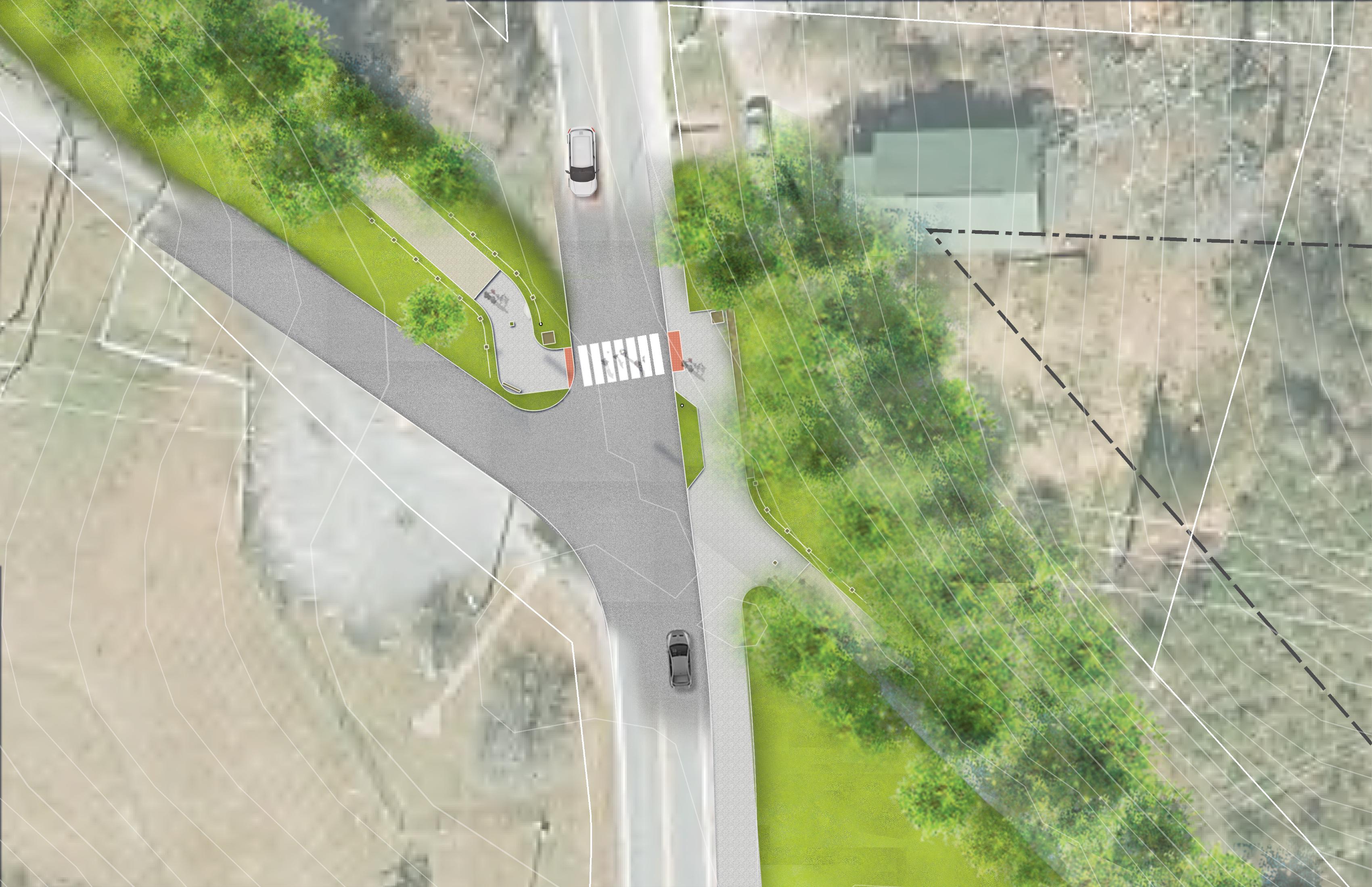
RECOMMENDATION 1.2: ALABAMA & VIRGINIA AVENUE TRAIL CROSSINGS
The trail parallels Spring Street as it crosses Alabama and Virginia Avenues. This short section of neighborhood green space will be enhanced with an allée of ornamental trees and benches to provide an area of refuge for trail users.

46 Recommendations
The trail parallels Spring Street for a short distance and is adjacent to open green space.
Alabama
Branded Crossing and Bollard
Possible Location of Future Neighborhood Greenspace
Branded crossings at Alabama and Virginia Avenues and an allée of ornamental trees along Spring Street will provide a safe corridor for the trail. The crossings will enhance pedestrian safety by providing a visual cue for both drivers and pedestrians.

SpringSt
Seating
Allee of Flowering Trees
Ave
Virginia Ave
EXH 06 : Alabama & Virginia Avenues Trail Crossings
RECOMMENDATION 1.3: RAIL TRAIL FENCING BETWEEN VIRGINIA & GEORGIA AVENUES
The rail trail is elevated significantly above the surrounding terrain between Virginia and Georgia Avenues. Fencing along this section of the trail will increase safety for trail users and be consistent in appearance with fencing located at trail entrances.

48 Recommendations
 The rail trail is elevated significantly above the surrounding terrain for a short distance in this residential area.
EXISTING CONDITIONS
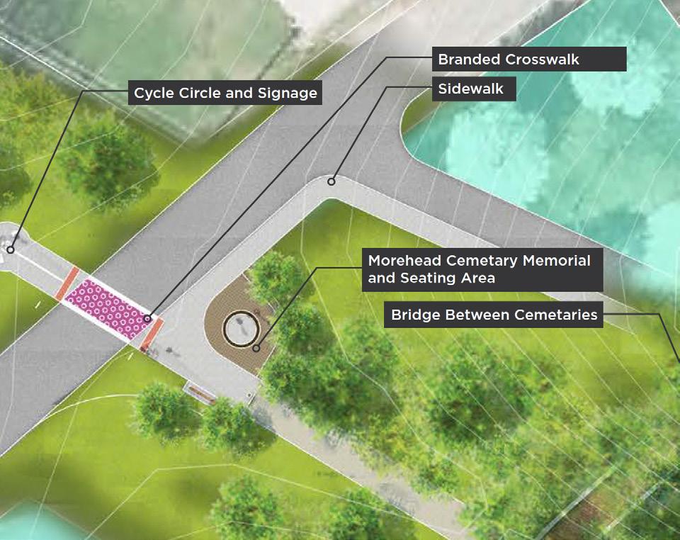
RECOMMENDATION 1.4: GEORGIA AVENUE & MOREHEAD ROAD TRAIL CROSSING
The Peavine Trail approaches Oak Grove and Morehead Cemeteries at the Georgia Avenue/Morehead Road crossing. A small seating area, interpretive waysides, and memorial will provide trail users with a contemplative resting area.
EXH 07 : Georgia Avenue/Morehead Road Trail Crossing
Intersection enhancements at Georgia Avenue/Morehead Road include a cycle circle, branded crosswalk, and sidewalk connection. A granite sign, memorial and seating area for Morehead Cemetery will formally mark the entrance to the cemetery from the Peavine Trail. A bridge will provide a connection between Oak Grove and Morehead Cemeteries.
 Cycle Circle and Signage
Branded Crosswalk Sidewalk
Morehead Cemetary Memorial and Seating Area
Bridge Between Cemetaries
Cycle Circle and Signage
Branded Crosswalk Sidewalk
Morehead Cemetary Memorial and Seating Area
Bridge Between Cemetaries
GeorgiaAve
50 Recommendations
A seating wall will give trail users a temporary resting place and interpretive signs will present trail users with information about the history of Morehead Cemetery. A sidewalk will provide a safe connection to the Morehead Cemetery entrance.

EXISTING CONDITIONS

EXH 08 : Georgia Avenue/Morehead Road Rendering
RECOMMENDATION 1.5: CEMETERY CONNECTIONS
A short natural surface trail will provide a direct connection from the Peavine Rail Trail to Oak Grove Cemetery on the southwest side of the trail about midway between Georgia Avenue/Morehead Road and Baldwin Avenue. This trail, in combination with a bridge and the sidewalk and driveway connection to Morehead Cemetery at the Georgia Avenue/Morehead Road crossing, will provide a short figure eight loop with the Peavine Rail Trail (See Map 6: Peavine Cemetery Connections, page right). The existing parking area for Morehead Cemetery will also serve as an informal trailhead for the Peavine with this trail connection.

52 Recommendations
The Morehead and Oak Grove Cemeteries reflect the rich history and cultural diversity of the City of Marion. This area will provide a peaceful spot along the Peavine Rail Trail for users to stop and contemplate the area’s storied past and pay respect to its former inhabitants.
Cross St Columbia Ave Circle EmSt Ridge St Shop Dr Columbia Ave MoreheadRd Tennessee Ave Georgia Ave B a l d w i n Ave S t a t e R d 1 7 0 3 RutherfordRd StateHwy226 USHwy221Bus youngs fork Existing Peavine Trail Cemetery Parcels Cemetery Trail Connector streams and creeks N Morehead cemetery parking P 0 500 250 Feet P Map 06 : Peavine Cemetery Connections
RECOMMENDATION 1.6: RAIL TRAIL FENCING AT OAK GROVE CEMETERY
The rail trail is elevated significantly above Oak Grove Cemetery and the Duke Energy substation north of Baldwin Avenue. Fencing along this section of the trail will increase safety for trail users and be consistent in appearance with fencing located at other trail locations.

54 Recommendations
 The rail trail is elevated significantly above a section of Oak Grove Cemetery and the Duke Energy substation.
EXISTING CONDITIONS
RECOMMENDATION 1.7: BALDWIN AVENUE CROSSING
Baldwin Avenue represents one of the busiest road crossings along the trail. A small parking area and substation access road is located on Duke Energy property to the southwest of the trail. This crossing location will be ideal for a formal trailhead on adjacent property.
EXH 09 : Baldwin Avenue Crossing
The Baldwin Avenue crossing will incorporate a realigned high visibility crosswalk to increase pedestrian safety. A small open green near the trail will provide space for a pocket park.
Future Discussions
 Parklet and Proposed MultiFamily Housing on Adjacent Property
Future DOT Project TBD
with Duke Energy
Parklet and Proposed MultiFamily Housing on Adjacent Property
Future DOT Project TBD
with Duke Energy
56 Recommendations
The Baldwin Avenue crossing will feature trail monuments, mile marker, and fencing to provide a consistent branded identity for the trail.

EXH 10 : Baldwin Avenue Rendering
RECOMMENDATION 1.8: MARION STREET CROSSING
The rail trail leaves a wooded setting as it approaches Marion Street from the northwest and enters a more developed setting along Glenwood Avenue. Crossing enhancements will be consistent with the other road crossings and improve pedestrian safety. The existing parking area for Morehead Cemetery will also serve as an informal trailhead for the Peavine with this trail connection.

58 Recommendations
The existing Peavine Rail Trail enters a wooded setting near Marion Street as it continues north.
EXISTING CONDITIONS

Branded Crosswalk Signage EXH 11 : Marion Street Crossing
Fencing
A branded crossing at Marion Street will enhance safety at this intersection. Branded signage and fencing will visually connect this crossing with the others in the rail corridor.
SECTION 2: FORD WAY TO JACKTOWN ROAD
The Peavine Trail continues from Ford Way through the parking lot of First Christian Church southeast to Jacktown Road, passing through woodlands and sparse commercial and industrial uses.
Section Length: 0.88 Miles
Trail Setting: Woodlands
Sparse commercial and Industrial land uses
Existing Points of Interest: Trestles
60
Plato Dr Hunte r D r Ford Way NMain St GlenwoodAve WoodChuckLn HeavenheightsLn Woodchuck L n Jacktown Rd WoodchuckLn FoxwoodDr State Rd1734 US Hwy 221Byp RutherfordRd USHwy221Bus StateHwy226 youngsfork 2 . 1 first christian church Trailhead 2 . 2 Trestles 2 . 3 Passive park opportunity 2 . 4 mixed - use redevelopment opportunity 2 . 5 jacktown rd trailhead Existing Peavine Trail Recommendations Planned Peavine Trail streams and creeks City or county property Marion city limits CSX Railroad N 0 0 . 5 0 . 25 Miles Map 07 : RecommendationsSection 2
RECOMMENDATION 2.1: FIRST CHRISTIAN CHURCH TRAILHEAD
The existing Peavine Trail is defined by a narrow asphalt strip adjacent to the First Christian Church parking area and is difficult to find. Currently, the trail and parking spaces are delineated by painted white lines. A sign notes no parking during Sunday church hours. A trailhead monument, mile marker, and bench at this location would promote it as a formal trailhead.

62 Recommendations
The Peavine Trail is defined by a narrow asphalt strip and painted white line on the edge of the First Christian Church parking area.
GLENWOOD AVE
FORDWAY
FIRST CHRISTIAN CHURCH
The existing Peavine Trail is defined on the edge of the parking area by a solid white line that marks it and parking spaces within the First Christian Church parking area. Bollards or short posts along the trail edge would better delineate the path for trail users.
 TRAILHEAD MONUMENT
BENCH
BOLLARD (x9)
TRAILHEAD MONUMENT
TRAILHEAD MONUMENT
BENCH
BOLLARD (x9)
TRAILHEAD MONUMENT
EXH 12 : First Christian Church Trailhead & Rail Trail
PEAVINE RAIL TRAIL
RECOMMENDATION 2.2: TRESTLES
On this section of the proposed trail, there are two abandoned railroad trestles that cross small streams. The northern trestle is approximately 300 feet long and the southern trestle is approximately 150 feet in length. The trestles offer unique points of interest along the Peavine Rail Trail that provide a reminder of the history of the railroad corridor. The trestles will be modified and repaired to keep their historical look and provide safe passage for trail users.


64 Recommendations
In January 2019, the City of Marion contracted with Kimley-Horn to conduct the Peavine Trail Trestles Feasibility Study and evaluate the two existing trestles for conversion into pedestrian bridges.

The consultant determined that both trestles have significant foliage overgrowth, and in many areas, exterior beams are deteriorated beyond repair and the timber is rotted. The study recommended and provided cost estimates for repurposing the existing trestles through a series of modifications and repairs. A cost estimate was also provided for demolishing the existing trestles, rerouting the trail, and utilizing shorter pedestrian bridges
Source: Peavine Trail Trestles Feasibility Study

EXH 13 : Peavine Trail Trestles Feasibility Study
RECOMMENDATION 2.3: PASSIVE PARK OPPORTUNITY
A large 10.5 acre parcel of vacant land adjacent to the trail contains Youngs Fork and a wide floodplain. This site could present an opportunity for city officials to develop a passive park if the landowner is willing to sell or donate the property. Due to the site’s location next to the stream and within the floodplain, the purchase price and associated costs may be covered by grant funding sources like the North Carolina Land and Water Fund (See Map 8: Passive Park & Mixed Use Redevelopment Opportunities, page right).

66 Recommendations
A large parcel adjacent to the rail trail provides a passive park and mixed-use redevelopment opportunity. The City can use grant funding to acquire the floodplain, and seek a private investor to develop the remaining portion of the property.
PlatoDr NMain St Woodchuck Ln FoxwoodDr Stat e Rd1734 Foxwood Dr State Rd 1734 Jacktown Rd USHwy 221Byp RutherfordRd USHwy221Bus StateHwy226 youngs fork Planned Peavine Trail areas of interest streams and creeks Marion city limits N 100 year floodplain CSX Railroad ~~~ ~ ~~~ ~ 0 500 250 Feet Map 08 : Passive Park & Mixed Use Redevelopment Opportunities
RECOMMENDATION 2.4: MIXED-USE REDEVELOPMENT OPPORTUNITY

A 15.3 acre parcel formerly used as a sawmill with a dry kiln and lumber yard is located adjacent to the trail and Jacktown Road. The site is next to an identified public park opportunity, and with private investment it could become a major node along the trail accommodating residential units, shopping, restaurants, services, and office space (See Map 8: Passive Park & Mixed Use Redevelopment Opportunities, page 67).
EXH 14 : Trails & Mixed Use Developments
Innovation Quarter - Winston Salem, NC
In Winston Salem, North Carolina, the Innovation Quarter represents a vision for a research park led by city, county and state governments, educational institutions, local businesses, developers, and community members. The development offers a place for diverse businesses, residential apartments, research institutions, and public greenspace. The Long Branch Trail is a 1.7-mile greenway that runs the length of the Innovation Quarter and connects to other greenways, trails, and the larger community.
68 Recommendations
Union Square - Hickory, NC

Union Square is the centerpiece of downtown in Hickory, North Carolina, with shops, restaurants, and outdoor spaces that host farmers markets, public events, and dining. The recently developed Hickory City Walk runs adjacent to the site and parallel to an active Norfolk Southern railroad line. The ten-foot-wide, shared use path is part of the larger planned Hickory Trail that features a series of interconnected paths that provide connectivity throughout the city.

Southside Works - Pittsburgh, PA
Southside Works is a large development in Pittsburgh, Pennsylvania, that houses local and national retailers, restaurants, fitness, and lifestyle shops. Recent investments include innovative office space, parks and greenspace, and residential living space. Nearby connections to the Three Rivers Heritage Trail, an urban rail trail paralleling the Monongahela River, provide residents with a place to live, work, and play.
69 Recommendations
Photos by others
RECOMMENDATION 2.5: JACKTOWN ROAD TRAILHEAD
The abandoned railroad corridor crosses Jacktown Road before merging into an active CSX Transportation railroad line. At this location, an alternative alignment will need to be utilized to connect the rail trail at Jacktown Road with McDowell Technical Community College to the south. The study area ends at Jacktown Road.
Jacktown Road will serve as the southern terminus for the Peavine Rail Trail until a connection to McDowell Technical Community College is determined. Due to an uncertain timeline for this extension, a small formal trailhead with an information kiosk and parking would be appropriate within the abandoned corridor on the northwest side of Jacktown Road.

70 Recommendations
 A small formal trailhead within the abandoned railroad corridor on the northwest side of Jacktown Road would mark the southern terminus of the trail.

IMPLEMENTATION
5.1 General Implementation Recommendations
5.2 Physical Needs Summary and Estimate of Probable Costs
5.3 Funding Opportunities
This chapter includes general implementation recommendations and a review of site specific recommendations for the trail corridor with an estimated probable cost range. The section concludes with a review of potential grant funding opportunities.

5
5.1 GENERAL IMPLEMENTATION RECOMMENDATIONS
Prior to implementation of this project, the City of Marion needs to complete a property boundary survey of the corridor to determine exactly where the 100-foot wide railroad easement is located in reference to adjacent properties, DOT right-of-ways, and the active railroad easement on the southern end of the corridor study area (See Appendix E: Corridor Deed, page 107). Along some sections of the trail, encroachments exist within the rail trail corridor. The City needs to identify areas of encroachment and resolve them with property owners.
A design level topographic survey will be required to complete engineering for the project. Due to the proposed trail type, features in the surrounding environment, and expected level of use, the Peavine Rail Trail should be designed and engineered for maximum sustainability and longevity. An appropriate design may include a crowned trail surface, ditches, and culverts to effectively deal with stormwater within the trail corridor. A design level survey can be included when the property boundary survey is completed.

74 Implementation
Encroachments within the railroad corridor need to be identified and resolved.

5.2 PHYSICAL NEEDS SUMMARY AND ESTIMATE OF PROBABLE COSTS
This project summary matrix provides a listing of general and specific site recommendations from Chapter 4 with comments and an estimated cost range. The branding and signage cost estimate is included within specific site recommendations that incorporate these elements. The estimate for trail type recommendations include design, engineering, and construction. Road crossing recommendations reflect elements included in the standard road crossing enhancements (See Exhibit 4, page 41).
76 Implementation
77 General Peavine Rail Trail Recommendations Branding and Signage Estimated cost range is noted within total for specific site recommendations. Not applicable Trail Type Includes design, engineering, and construction. $1,300,000-$1,650,000 Road Crossings Includes five standard road crossing enhancements (See Exhibit 4, page 41). $125,000 Specific Site Recommendations SECTION 1: STATE STREET TO FORD WAY 1.1: State Street Trail Entrance Trail monument, fencing, mile marker, and benches $40,000-$55,000 1.2: Alabama and Virginia Avenue Trail Crossings Landscaping $5,000-$10,000 1.3: Rail Trail Fencing between Virginia and Georgia Avenues 1,150 LF $34,500-$46,000 1.4: Georgia Avenue and Morehead Road Trail Crossing Sidewalk connection, cemetery sign, small seating area, interpretive waysides, and memorial $60,000-$75,000 1.5: Cemetery Connections Bridge (200’) and natural surface trail (100’) $250,000-$275,000 1.6: Rail Trail Fencing at Oak Grove Cemetery 800 LF $24,000-$32,000 1.7: Baldwin Avenue Crossing Open green $3,000-$5,000 1.8: Marion Street Crossing Signage and fencing $15,000-$20,000 SECTION 2: FORD WAY TO JACKTOWN ROAD 2.1: First Christian Church Trailhead Trail monument, mile marker, bench, and bollards $30,000-$40,000 2.2: Trestles Modification and repair of trestles $980,000-$1,100,000 2.3: Passive Park Opportunity Potential land acquisition may be reimbursed with grant funding TBD 2.4: Mixed-use Redevelopment Opportunity Potential project for private developer TBD 2.5: Jacktown Road Trailhead Small trailhead with parking and kiosk $30,000-$40,000 TOTAL $2,908,500-$3,473,000 COMMENTS ESTIMATED COST RANGE EXH 15 : Project Summary Matrix
5.3 FUNDING OPPORTUNITIES
The Marion Peavine Rail Trail recommendations focus on improvements to an existing rail trail and development of an extension to the trail along the abandoned railroad corridor. The trail represents a feasible recreation, health, and tourism project for the City of Marion.
Many federal, state, and foundation grants and funding sources have a recreation or health focus (See Exhibit 16: Grant Funding Opportunities, page right). The City should develop a grant procurement strategy that leverages grants “against each other” to minimize the amount of matching funding contributed from local dollars. The City may appropriate funding from the City budget and request funding from McDowell County Tourism Development Authority occupancy tax revenues to supplement project funding.
78 Implementation
79 EXH 16 : Grant Funding Opportunities Matrix
PEAVINE TRAIL IMPLICATIONS MAXIMUM AMOUNT MATCHING FUNDS REQUIRED DEADLINES NC Parks and Recreation Trust Fund (PARTF) All types of parks, trails, and recreation facilities $500,000 50% Early May NC Recreational Trails Program (RTP) All types of trails, greenways, and paddle access areas $100,000 25% Varies McDowell County Tourism Development Authority Tourism-related infrastructure development Varies Varies Varies NC Water Resources Development Grant Program Greenways, boardwalks, and water access areas Varies 50% Late December/ Late June People for Bikes Community Grant Bike Trails and Greenways $10,000 50% Spring/Fall NC Land and Water Fund Land
or stabilization Varies Varies Early February AARP Community Challenge Grant Help communities become more livable for people of all ages Varies N/A Early March T-Mobile Hometown Grant Community and Public Spaces $50,000 N/A Rolling/Quarterly
PARTNERSHIP FUNDING AGENCY MARION
acquisition, stream restoration, enhancement,

APPENDIX
A: Phase I Environmental Assessment Executive Summary
B: NRCS Soil Map
C: Public Engagement Meeting Comments
D: Peavine Trail Trestle Feasibility Study

E: Corridor Deed

A
SUMMARY
S&ME, Inc. performed a Phase I Environmental Site Assessment (ESA) for subject property located approximately 0.1 mile northeast of State Street continuing to the southeast where it terminates approximately 0.2 miles southeast of Jacktown Road in Marion, McDowell County, North Carolina. The following summary is intended as an overview of the Phase I ESA, and does not include the complete findings and opinions of the full report.
The Phase I ESA included research of public records for the subject property and surrounding properties that might have a bearing on the subject property, interviews with local authorities, a reconnaissance of the subject property and the surrounding area in preparation of this report.
The subject property consists of an approximately 2½ mile long by 100-foot wide section of former Norfolk Southern railroad line located in the southeast portion of the city of Marion, North Carolina. The subject property is currently owned by the City of Marion, North Carolina.
The subject property is currently developed as a hiking/biking trail. Track ballast and soil cover the majority of the trail. Several chain-link fences are located along the trail designating sections that are currently closed to the public including one trestle. Stop signs and other trail signage are present on the property.
S&ME contracted Environmental Data Resources (EDR), to conduct an environmental search and prepare a Radius Map with GeoCheck® Report (EDR Report) compiling federal, state, and tribal environmental database information from the regulatory records of the United States Environmental Protection Agency (US EPA), the State of North Carolina, and available tribal sources. The purpose of the EDR Report was to identify environmental sites and activities within a radius of potential concern from the subject property, as outlined by ASTM Standard Practice E 1527-05. According to the EDR Report, the subject property is not listed in the searched databases. The following mapped sites were identified by EDR: three (3) RCRA Conditionally Exempt Small Quantity Generators, two (2) Emergency Response Notification System records, one (1) US Clandestine Drug Lab location, eight (8) Facility Index System sites, one (1) Historical US Clandestine Drug Lab location, one (1) NC Leaking Underground Storage Tank site, and five (5) NC Registered Underground Storage Tank sites. None of the mapped sites are considered a recognized environmental condition
Creosote-treated railroad ties have historically been used for railroad track construction. Piles of excavated ties are still present on the southern portion of the property. Creosote contains polycyclic aromatic hydrocarbons (PAHs) which can be released from the treated wood. According to Brooks (2004) it is reasonable to expect a detectable migration of creosote-derived PAHs from newly treated railroad ties into supporting ballast during their first exposure to hot summer weather. The PAHs rapidly disappear from the ballast during the fall and winter following the initial summer loss. Then statistically insignificant vertical and horizontal migration of these PAHs suggest
Phase I ESA Report
S&ME Project No. 1411-11-007
Peavine Trail (Former Norfolk Southern Rail Line)/ Marion, NC February 21, 2011
that they either evaporated or were degraded in the ballast. Based on interviews conducted with Mr. Neal and Mr. Boyette, the former rail line located on the subject property was taken out of service in the mid 1970s. Based on the length of time since the former railroad track on the subject was in service, the presence of creosote-treated railroad ties on the subject property are not considered to be a recognized environmental condition.
Several above-ground storage tanks were observed at the residences and businesses adjoining the subject property. Storage tanks have the potential to leak and leach contaminants into the soil and groundwater. None of the storage tanks observed gave indications such as excessive rust or staining that they were leaking. If a release from a storage tank on an adjoining property were to occur impacting the soil and/or groundwater, the tank owner would be the responsible party for any required assessment and/or remediation, therefore; the above-ground storage tanks observed on properties adjoining the subject property are not considered to be a recognized environmental condition
Buildings labeled as glue room, engine room, machine shop, junk, and painting/spraying are identified on the adjoining Catawba Furniture Company property on the Sanborn Fire Insurance maps from 1902 to 1939. This property was utilized as a concrete plant at the time of the site reconnaissance. Based on the property location, topography suggests contaminant migration would be to the south towards Youngs Fork, not towards the subject property. Based on this information, the previous building uses on the Catawba Furniture Company property adjoining the subject property are not considered to be a recognized environmental condition
1. INTRODUCTION
S&ME, Inc. (S&ME) conducted a Phase I ESA of the above referenced property. The ESA was conducted using the American Society for Testing and Materials (ASTM) E 1527-05, Standard Practice for Environmental Site Assessments: Phase I Environmental Site Assessment Process. S&ME’s services were authorized by Mr. Jim B. Edwards, Executive Director with Isothermal Planning and Development Commission, and were completed in general accordance with S&ME, Inc. Proposal No. ENV-160-10 dated November 4, 2010.
1.1 Purpose
The purpose of the ESA is to identify, pursuant to ASTM E 1527-05, recognized environmental conditions in connection with the subject property. ASTM defines the term recognized environmental condition (REC) as the presence or likely presence of hazardous substances or petroleum products on the property under conditions that indicate an existing release, past release, or a material threat of a release of hazardous substances or petroleum products into the structures on the property or into the ground, groundwater, or surface water of the property. The term does not included de minimis conditions that generally do not present a material risk of harm to public health or the environment and that generally would not be the subject of enforcement action if brought to the attention of appropriate governmental agencies.
82
Phase I ESA Report
S&ME Project No. 1411-11-007
3
Peavine Trail (Former Norfolk Southern Rail Line)/ Marion, NC February 21, 2011
4
AppendixA : Phase I Environmental Assessment Summary
S&ME Project No. 1411-11-007
Peavine Trail (Former Norfolk Southern Rail Line)/ Marion, NC February 21, 2011
1.2 Detailed Scope of Services
1.2.1 ASTM E 1527-05
S&ME's approach to performing this Environmental Site Assessment consisted of four major tasks in accordance with ASTM Standard Practice E 1527-05.
Task 1 - A review of reasonably ascertainable public records for the site and the immediate vicinity was conducted. This review was performed to characterize environmental features of the site and to identify past and present land use activities, on or in the vicinity of the site, which may indicate a potential for recognized environmental conditions. The review of the reasonably ascertainable public records included:
1. Examination of federal, state, tribal and reasonably ascertainable local public records for the site and immediate vicinity.
2. Examination of one or more of the following standard historical sources: aerial photographs, fire insurance maps, tax files, building department records, zoning/land use records, street directories and topographic maps of the site and vicinity for evidence suggesting past uses that might have involved hazardous substances or petroleum products.
Task 2 - A site reconnaissance was performed to identify visual signs of past or existing contamination on or adjacent to the site. This reconnaissance was also performed to evaluate evidence found in our public record review that might indicate activities resulting in hazardous substances or petroleum products being used or deposited on the site. The site reconnaissance included the following activities:
1. A reconnaissance of the site was performed to look for evidence of current and past property uses, signs of spills, stressed vegetation, buried waste, underground or above ground storage tanks, subsidence, transformers, or unusual soil discoloration which may indicate the possible presence of contaminants on the properties. Photographs are provided to document these conditions.
2. The exterior reconnaissance involved a viewing of the periphery of the property and a walk-through of accessible areas of the site interior including the exterior of on-site structures.
3. The interior reconnaissance involved a walk-through of the interior of accessible rooms within the onsite structures.
Task 3 – Interviews with the present property owner/property manager and business managers/employees, as well as appropriate local officials were conducted to consider local knowledge of hazardous substances or petroleum products on the property or on adjacent properties.
Task 4 - Report preparation and review.
1.2.2 Exclusions from and Additions to Scope of Services
Unless specifically authorized as an addition to the Phase I ESA work scope, the assessment did not include any assessment of environmental conditions not specifically included in the ASTM E1527-05 standard including, but not limited to sampling of materials (i.e., soil, surface water, groundwater or air), or the assessment of business risk issues such as wetlands, lead in drinking water, asbestos containing materials, mold, fungi or bacteria in on-site buildings, regulatory compliance, cultural/historic risks, industrial hygiene, health/safety, ecological resources, endangered species, indoor air quality (including an evaluation of vapor intrusion), radon or high voltage power lines.
1.3 Significant Assumptions
A significant assumption used in evaluating potential impacts to the subject property of nearby, off-site incidents was that the groundwater within the local geologic province is typically contained in an unconfined (water table) aquifer. The slope of the water table under static conditions (no pumping interference) often approximates the land surface topography. Thus, the interpreted groundwater flow direction is assumed to be approximately the same as the dip of the ground surface. Perennial surface waters (creeks, streams, rivers, etc.) are assumed to act as a discharge point for groundwater flow.
1.4 Limitations and Exceptions of Assessment
The Phase I Environmental Site Assessment was conducted using ASTM E 1527-05. The findings of this report are applicable and representative of conditions encountered at the property on the date of this assessment, and may not represent conditions at a later date. The review of public records was limited to that information which was available to S&ME at the time this report was prepared. Interviews with local and state government authorities were limited to those people whom S&ME was able to contact during the preparation of this report. Information was derived from “reasonably ascertainable” and “practically reviewable” sources in compliance with our understanding of the standards set forth by ASTM E 1527-05.
A limitation of the Phase I ESA was that standard historical sources were not reasonably ascertainable to trace the operational history of the property since 1940 in approximately five year intervals because standard historical sources, such as additional aerials photographs or Sanborn Maps, were not readily ascertainable to obtain the information.
The client was responsible for reviewing land title and judicial records for environmental liens and activity and use limitations. The results of that review were not shared with S&ME, Inc. Information provided by the client, including the User Questionnaire, is assumed to be correct.
1.5 Special Terms and Conditions
This Phase I ESA was conducted in general accordance with S&ME Proposal No. ENV160-10 dated November 4, 2010. Agreement for Professional Services (Contract# 11001) is incorporated into the Proposal, a copy of which is included in Appendix VII.
83
Phase I ESA Report
5
6
Phase I ESA Report S&ME Project No. 1411-11-007 Peavine Trail (Former Norfolk Southern Rail Line)/ Marion, NC February 21, 2011
Phase I ESA Report S&ME Project No. 1411-11-007
Peavine Trail (Former Norfolk Southern Rail Line)/ Marion, NC February 21, 2011
1.6 User Reliance
The resulting report is provided for the sole use of Isothermal Planning and Development Commission and the City of Marion, North Carolina. Use of this report by any third parties will be at such party’s sole risk except when granted under written permission by S&ME. Any such authorized use or reliance by third parties will be subject to the same Agreement, under which the work was conducted for Isothermal Planning and Development Commission.
The additional party's use and reliance on the report will be subject to the same rights, obligations, and limitations imposed on the client by our Agreement. However, the total liability of S&ME to all parties of the Phase I ESA shall be limited to the remedies and amounts as provided in the Agreement as a single contract. The additional party's use and reliance on the report shall signify the additional party's agreement to be bound by the proposal and contract that make up the Agreement between S&ME and Isothermal Planning and Development Commission.
2. SITE DESCRIPTION
2.1 Site Location
The subject property is an approximately 2½ mile long by 100-foot wide section of former railroad line located in the southeast portion of the city of Marion, McDowell County, North Carolina. The location of the site is depicted on the Location Map, presented as Figure 1 in Appendix I.
The subject property begins approximately 0.1 mile northeast of State Street at the intersection with the active Norfolk Southern rail line and continues to the southeast where it terminates approximately 0.2 miles southeast of Jacktown Road at the intersection with the active Norfolk Southern rail line. No parcel identification number has been assigned to the property by McDowell County as of the issuance of this report. The approximate boundaries of the subject property are depicted on Figure 3 in Appendix I.
2.2 Site and Vicinity Characteristics
The site is a former rail line and is level to gently sloping along its length. Groundcover consists of railroad ballast and soil. Access to the property can be gained from several cross streets along the length of the property. The properties surrounding the subject property are primarily developed as light industrial, commercial/retail, residential, and undeveloped properties.
In general, the topography of the subject property and immediate adjoining properties slope to the southwest towards Youngs Fork.
2.3 Current Uses of the Property
The property is currently used as a hiking/biking trail.
84
7


85 AppendixB : NRCS Soil Map Natural Resources Conservation Service Web Soil Survey National Cooperative Soil Survey 12/28/2022 Page 1 of 3 3947000 3947400 3947800 3948200 3948600 3949000 3949400 3947000 3947400 3947800 3948200 3948600 3949000 3949400 408500 408900 409300 409700 410100 410500 410900 411300 411700 412100 412500 408500 408900 409300 409700 410100 410500 410900 411300 411700 412100 412500 35° 41' 9'' N 82° 0' 41'' W 35° 41' 9'' N 81° 57' 56'' W 35° 39' 42'' N 82° 0' 41'' W 35° 39' 42'' N 81° 57' 56'' W N Map projection: Web Mercator Corner coordinates: WGS84 Edge tics: UTM Zone 17N WGS84 05001000 2000 3000 Feet 0250500 1000 1500 Meters Map Scale: 1:18,900 if printed on A landscape (11" x 8.5") sheet.
Area of Interest (AOI)
Soils
Soil Map—McDowell County, North Carolina (Marion Peavine)
MAP LEGEND MAP INFORMATION
Area of Interest (AOI)
Soil Map Unit Polygons
Soil Map Unit Lines
Soil Map Unit Points
Special Point Features
Blowout Borrow Pit
Clay Spot
Closed Depression
Gravel Pit
Gravelly Spot
Landfill
Lava Flow
Marsh or swamp
Mine or Quarry
Miscellaneous Water
Perennial Water
Rock Outcrop
Saline Spot
Sandy Spot
Severely Eroded Spot
Sinkhole
Slide or Slip
Sodic Spot
Spoil Area
Stony Spot
Very Stony Spot
Wet Spot
Other
Special Line Features
Water Features
Streams and Canals
Transportation Rails
Interstate Highways
US Routes
Major Roads
Local Roads
Background
Aerial Photography
The soil surveys that comprise your AOI were mapped at 1:24,000.
Please rely on the bar scale on each map sheet for map measurements.
Source of Map: Natural Resources Conservation Service
Web Soil Survey URL:

Coordinate System: Web Mercator (EPSG:3857)
Maps from the Web Soil Survey are based on the Web Mercator projection, which preserves direction and shape but distorts distance and area. A projection that preserves area, such as the Albers equal-area conic projection, should be used if more accurate calculations of distance or area are required.
This product is generated from the USDA-NRCS certified data as of the version date(s) listed below.
Soil Survey Area: McDowell County, North Carolina
Survey Area Data: Version 24, Sep 14, 2022
Soil map units are labeled (as space allows) for map scales
1:50,000 or larger.
Date(s) aerial images were photographed: Apr 22, 2022—May 10, 2022
The orthophoto or other base map on which the soil lines were compiled and digitized probably differs from the background imagery displayed on these maps. As a result, some minor shifting of map unit boundaries may be evident.
86
Map Unit Legend
87
Map Unit Symbol Map Unit Name Acres in AOI Percent of AOI BrC2 Braddock clay loam, 6 to 15 percent slopes, eroded 1.8 2.2% BrD2 Braddock clay loam, 15 to 25 percent slopes, eroded 4.9 6.1% HeD Hayesville-Evard complex, 15 to 25 percent slopes 12.9 15.9% HrD Hayesville-Evard-Urban land complex, 15 to 25 percent slopes 32.6 40.3% HuC Hayesville-Urban land complex, 6 to 15 percent slopes 20.5 25.3% IoA Iotla sandy loam, 0 to 2 percent slopes, occasionally flooded 8.3 10.3% Totals for Area of Interest 81.0 100.0%
Soil Map—McDowell County, North Carolina Marion Peavine
Community Input Drop-in Session
Marion Community Building
Thursday, December 8, 2022 - 4-6 pm
● Peavine is very good
● Appreciate the opportunity to have input
● Work on trestles in particularly impressive
● Many thanks
● Thank you, thank you, thank you!
● So excited about the trail work
● RJR fund for exercise and active living
● Just for the area @ State St down to VA St. Leave it alone - maybe smoother trail
● The less done the better.
● We support the Peavine Rail to Trail project and the current plan
● Consider handi cap access
● Safety items on trestles and large hills
● Instead of rebuilding trestles excavate on each side and replace with a smaller bridge
88
AppendixC : Public Engagement Meeting Comments
PEAVINE TRAIL TRESTLES
Peavine Trail Trestle Feasibility Study (EB-5542)


January 2019 – Marion, North Carolina


Peavine Trail Trestles
Peavine Trail is a current pedestrian trail located in Marion, North Carolina The trail follows an existing railroad corridor that has been repurposed for pedestrian usage. In its current state, the trail begins at State Street and runs southeast to Ford Way. The City of Marion and The North Carolina Department of Transportation (NCDOT) have plans to extend the Peavine Trail to the southeast along the existing railroad corridor. Along the proposed extension of the trail are two railroad trestles that span small creeks. The City asked Kimley-Horn to evaluate the two abandoned railroad trestles for possible conversion into pedestrian bridges for the trail extension
Kimley-Horn performed a site visit to Marion, North Carolina on October 3rd, 2018 to observe and document the current condition of the two trestle bridges along the existing railroad corridor Photographs were taken during the site visit to document the condition of the trestles. Full photographic documentation can be found in the photo log in Appendix A. On the day of the site visit, the weather was mostly sunny with temperatures in the mid-80s. Kimley-Horn’s scope included a site visit that was limited to visual, nondestructive observations of the readily accessible portions of each trestle In addition, Kimley-Horn will provide two alternatives for converting the existing trestles to pedestrian bridges The scope did not include structural calculations, materials testing, hydraulic calculations, geotechnical services, construction documents or any additional services that were not explicitly described in the original scope of services.
The following section of this report describes the two trestle bridges based on the site visit and information provided by the City of Marion. For general location and naming convention of the trestles, please see Figure 1, below.
89
FEASIBILITY STUDY JANUARY 2019
1
Figure 1: Location map and naming convention for trestle bridges
AppendixD : Peavine Trail Trestle Feasibility Study
Peavine Trail Trestle Feasibility Study (EB-5542)
January 2019 – Marion, North Carolina
General Description
Railroad line was in operation until 1983.
The land was purchased by the City of Marion from Norfolk Southern Railway in 2010
Both trestles have significant foliage and overgrowth around/on them which partially obscures them from view


Both trestles span over minor streams that feed into Youngs Fork
Trestle One has 16 spans and is approximately 25’ above the ground surface at its highest point
Trestle Two has 9 spans and is approximately 15’ above the ground surface at its highest point
Per field measurements, the approximate span length was 14’–0”, typical for all spans on both trestles. The substructure consists of timber bent caps, each supported by six (6) timber piles.
Timber piles were tapered from top to bottom and have an approximate diameter of 12” near ground level.
Timber cap beams are approximately 16” width x 15” depth
Superstructure of both trestles consists of 18 beams that measure approximately 12” width x 15” depth
The railroad ties and rails have been removed from both trestles No ballast was visible on the trestles. The surface of each bridge has been covered with soil, which has allowed for vegetation growth.
Observed Previous Modifications and Repairs
Trestle One
o Two of the timber bent caps have been replaced with concrete bent caps.
o The concrete bent caps have been anchored to the piles with steel rods
o Bent 3 has a major pile repair on one of the exterior piles. The original pile was cut off near the ground line and replaced with a new square pile. This square pile is supported by at least three concrete members which appear to be bearing directly on the ground.
o Several piles were cut near the ground line. The top part of the existing pile was replaced with newer timber members (square in some cases and circular in other cases) with the existing pile remaining in the ground. In these cases, the new timber members were connected to the existing piles with railroad tie nails.
Trestle Two
o No obvious modifications or repairs.
Peavine Trail Trestle Feasibility Study (EB-5542)
January 2019 – Marion, North Carolina
Key Findings
Trestle One
Superstructure
There was a significant amount of overgrowth on Trestle One Kudzu is growing on the substructure elements and obstructing the view of these elements. In addition, the walking surface of the bridge has a significant amount of vegetation, including trees, growing over and covering the beams. Because of this overgrowth, the top of the deck/beams were inaccessible and the condition of the top of the beams is unknown.
90
2
3
Figure 3: Overgrown plants and foliage on Trestle One
Figure 2: Elevation view of Trestle One – showing significant overgrowth on structure
Peavine Trail Trestle Feasibility Study (EB-5542)
January 2019 – Marion, North Carolina
Underneath the trestle, the beams were more accessible/visible which allowed for some visual observation The exterior beams in nearly all spans were deteriorated beyond repair. In many cases there was significant section loss and severe rotting of the timber, which is shown in Figure 4.

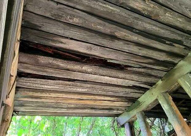
In some select spans, the exterior beams have begun to separate from the interior beams, allowing for openings in the deck, which can be seen in Figure 5
In various spans along the trestle, there was an assortment of interior beams with varying degrees of section loss, as seen in Figure 6 The level of decay in the interior beams varied, with some of the beams only showing minor decay, while other beams showed significant section loss and major rotting. Beams with major rotting will require full replacement, as the section loss is too significant for the member to be relied on to provide structural capacity


Peavine Trail Trestle Feasibility Study (EB-5542)
January 2019 – Marion, North Carolina
Substructure
Two of the timber bent caps have been replaced with concrete bent caps. These concrete caps were anchored to the piles using steel rods. The cap and the connection are both shown in Figure 7. In general, the concrete caps appeared to be in good condition with minimal cracking/spalling.
Many of the timber bent caps were inaccessible due to their height from the ground, therefore Kimley-Horn was only able to complete a visual assessment from the ground. Many of the bent caps were in generally good condition. However, there were several timber bent caps that would require replacement due to significant decay and rotting. For instance, Bent 7, shown in Figure 8, shows some severe splitting and general decay. This bent cap, and all similar caps, will require replacement.
Overall the piles were in fair condition with miminal section loss and decay. There was a single pile with some major section loss at the end bent that will need to be replaced. Additionally, there were several piles that had been cut near the ground line and spliced with a new section of pile. The portion of the pile that was in the ground remained in place and the portion of the pile above ground had been replaced with various timber members – some square and some circular The new timber members were connected to the existing pile (the portion in the ground) with a single railroad tie nail. Further investigavtion is requied to determine if this detail is structural y adequate An example of one of these piles is shown in Figure 9

91
4
Figure 6: Interior beam showing significant section loss in span 2
Figure 4: Significant deterioration of exterior beam, typical for exterior beams
Figure 5: Exterior beam that has rotated away from the interior beams, showing visible light from above
5
Figure 7: Concrete bent cap with connection to existing timber piles
Figure 9: Timber piling that has been cut and replaced with a circular timber member and connected with a railroad tie nail.
Figure 8: Timber bent cap with some section loss and decay
Peavine Trail Trestle Feasibility Study (EB-5542)
January 2019 – Marion, North Carolina
A major pile modification was completed on one of the exterior piles on Bent 3. The original pile was cut off near the gournd and replaced with a square pile. The load was taken from the square pile to the ground, bypassing the existing in-groud pile, by a system of concrete members bearing directly on the ground. This repair does not appear to be structurally adequate and would need to be modified or completely removed before the trestle could be placed in service. The pile modification can be seen in Figure 10.
Stream Conditions
The stream was generally calm during the site visit with minimal noticeable scour on either bank. There is no rip rap or other scour protection on the banks of the stream


Peavine Trail Trestle Feasibility Study (EB-5542)
January 2019 – Marion, North Carolina
Trestle Two
Superstructure
As with Trestle One, there was some overgrowth on top of the structure. Because of this overgrowth, the top of the deck/beams was inaccessible and the condition of the top of the beams is unknown

92
6
Figure 10: Timber piling resting on concrete members – a modification to the existing piles.
Figure 11: Stream under the Trestle One
7
Figure 13: Standing on top of Trestle Two, looking at the overgrowth on the superstructure
Figure 12: Elevation view of Trestle Two – showing some overgrowth on structure
Peavine Trail Trestle Feasibility Study (EB-5542)
January 2019 – Marion, North Carolina
The exterior beams in nearly every span have failed or have considerable damage. In many cases, the beams have separated from the interior beams due to falling trees or tree root systems from the vegetation on top of the trestle These beams should not be used to resist structural loading in any future modifications to the trestle.


In general, the interior beams of Trestle Two were in better condition than the interior beams of Trestle One. However, there were still several beams that showed signs of decay and section loss. Prior to reusing any interior beam, they will need to be investigated in more detail to determine which beams must be replaced.


Peavine Trail Trestle Feasibility Study (EB-5542)
January 2019 – Marion, North Carolina
Many of the timber bent caps were inaccessible due to their height from the ground, so Kimley-Horn was only able to complete a visiual assessment from the ground. Several of the timber bent caps were observed to have splitting and section loss. This damage was noticed almost exclusively on the ends of the timber bent caps It is anticipated that several of these timber bent caps will need to be replaced prior to the bridge being repurposed.
Overall the piles were in fair condition with miminal section loss and decay However, there were a few piles on this trestle with noticeable splitting. In addition, there were two piles on the last bent with significant section loss. These piles are not adequate and would need to be replaced with similar sized piles
Substructure
End Bent 1 (south end bent) has numerous issues relating to various structural members. First, there were backwall members showing signs of severe decay and section loss. This damage was noticeable at the ends of each backwall member. Additionally, the cap has numerous locations of spliting and failed timber that will require replacement Finally, one exterior pile has significant damage and is no longer providing any structural capacity. See Figure 16 for documentaion of the cap and pile damage.
93
8
Figure 14: Complete failure in exterior beam in second span
Figure 16: End Bent 1 pile cap, showing signs of decay
Figure 15: Interior beam showing several spans where the beams are generally in good condition
9
Figure 19: Significant section loss in two interior piles
Figure 17: Interior bent cap, showing signs of deterioration at the edge
Figure 18: Interior bent cap, highlighting the splitting of the timber piles
Peavine Trail Trestle Feasibility Study (EB-5542)
January 2019 – Marion, North Carolina
Stream Conditions
The stream at this location meandered more and had a higher velocity than the stream at Trestle One. Each bank of the stream has scour issues, both upstream and downstream. At the location of the trestle, several piles have experienced scour, which will need to be remediated prior to the structure being repurposed.

There was noticeable debris (tires, old trees, etc.) in the stream that is causing the stream to meander. The tires appeared to be supporting the west bank, however it was not clear if the tires were intended for scour protection or just debris that has become lodged in the stream bank.

Peavine Trail Trestle Feasibility Study (EB-5542)
January 2019 – Marion, North Carolina
Recommendations
Based on the information gathered during the site visit, two options were developed to continue developing Peavine Trail along the existing railroad line. Option One is to repurpose the existing trestles through a series of modifications and repairs. Option Two involves demolition of the existing structures and rebuilding similar structures at the same locations. Each of these options is discussed in more detail below.
A third option would be to realign the trail to avoid the existing trestle locations With this option, no modifications would be necessary, and the existing trestles would remain in place. It is recommended that access to the trestle decks be restricted since the structure would continue to deteriorate over time.
Option One – Repurpose Existing Trestles
The first option for the trestles is to repurpose them to accommodate pedestrian traffic as part of the Peavine Trail. Based on the current state of the trestles and observations from the site visit, Kimley-Horn believes that the trestles can be repurposed for use on a greenway trail. If the City chooses to move forward with repurposing the trestles, Kimley-Horn has developed a list of modifications/repairs to the trestles that are recommended for the repurposing These recommendations are discussed in more detail below.
Remove Exterior Beams
The exterior beams, in nearly all spans of both trestles, have failed or have significant section loss. These beams should be removed. Because of the width of the existing bridge and the necessary width for a greenway trail, replacing these members is not necessary.
Replace Damaged Timber Bent Caps and Timber Backwalls
Select timber bent caps and backwalls are failing in both trestles and should be replaced with samesized timber members Approximately 3 bent caps at each trestle and all backwalls will require replacement at this time. Additional bent caps could also need replacement with continued decay. The new timber bent caps and backwall members should be pressure treated to help with long term durability
Replace Damaged Interior Timber Beams
Multiple locations of damaged interior beams were observed during the site visit on both trestles. Any interior beam that has been damaged by roots or has section loss due to decay must be replaced with a similar-sized member. From the limited visual observations, it is estimated that approximately 25% of interior beams on Trestle One and 15% of interior beams on Trestle Two will require replacement. Visual inspection of the top of the beams was not possible due to vegetation on top of the trestle Depending on condition of the top side of the beams, more interior beams might require replacement.
94
10
Figure 20: Stream under the Trestle Two with various debris
Figure 21: Stream bank scour
11
Peavine Trail Trestle Feasibility Study (EB-5542)
January 2019
Marion, North Carolina
Repair timber piles
Multiple piles on Trestle One have been cut near the ground line and replaced with new piling. These piles should be wrapped with a pile jacket to ensure they are transferring the load to the existing piles in the ground. In addition, there are several damaged piles on both trestles that must be addressed These damaged piles can be repaired with a pile jacket to provide adequate structural capacity
Add Decking
Decking needs to be added to the to surface of the beams to create an acceptable surface for the greenway trail. There are two practical options for this trail surface. The first option involves providing timber decking boards placed transverse to the bridge This option would have a look consistent with typical boardwalk construction. The second option would be a concrete deck This option would consist of several inches of concrete with steel reinforcing to create the walking surface. The concrete deck would be more expensive than the timber decking option but would require less long-term maintenance.
Add Railing
A railing must be added on each side of the trestle for the structure to be used as a greenway trail This railing must be 54” above the walking surface and have openings of 6” or less to accommodate both pedestrians and bicyclist.
Remove Vegetation/Debris/Insects
Remove all vegetation and debris from both trestles. This includes the kudzu growing on the substructure and all vegetation on the top surface of the trestles. This process should be a regular maintenance item to prevent the vegetation from causing damage to the trestles. In addition, remove any standing debris, such as tree limbs, trash, etc. from the trestles and surrounding area. These materials allow moisture to build-up, which can increase the rate of deterioration of the structural members.
In addition, harmful insects will sometime nest inside the timber members of the bridge. Intermittently monitor and safely remove any insect nests affixed to the trestles to alleviate any pedestrian safety hazards and to prevent deterioration of structural members.
Power Wash and Apply Preservative Treatment to Timber Members
Power wash the entire structure to mitigate growth of mold/mildew. Once power washing is complete apply a preservative treatment to all timber members that remain to extend the lifespan of the existing timber members.
Stabilize Stream Bank
Remove the debris on and under the stream banks. Stabilize the stream bank at Trestle Two with armoring or riprap. Routinely monitor for and remove debris accumulation around bridge.
Peavine Trail Trestle Feasibility Study (EB-5542)
January 2019 – Marion, North Carolina
Option Two – New Trestle Structures
Option Two consists of replacing the existing trestles with new structures. In this option, the superstructure would be removed from the trestles followed by the bent caps and cross braces. The timber piles would be cut off near the existing ground line with the piles below ground remaining in place. Timber members that are not damaged could be reused in other applications. The new structure would then be constructed following roughly the same horizontal and vertical alignment. These new structures would be constructed of timber members and have a similar look to the old structures. Timber piles would be driven or drilled depending on soil conditions and then connected with crossing bracing and timber caps. Timber stringers would be used to span between bents with span lengths ranging from 10’ to 15’. Timber or concrete decking would be used for the surface of the bridge with AASHTO and NCDOT compliant railings. There are several advantages of providing new structures, which include less long-term maintenance, more control over the appearance, and more predictability in construction cost.
Option Three – Leave Existing Trestles & Realign Trail
Option Three consists of realigning the trail to the south side of the existing trestles and leaving the trestles in-place as-is. Realignment concepts for both trestles are shown in Appendix C For the purposes of this study, a typical section consisting of an 8 ft wide trail with 2 ft shoulders was assumed based on other segments of the trail and direction from the City of Marion Retaining walls were used at the north trestle to limit grading impacts into the railroad embankment, minimize fill in potential wetlands, and minimize the need to acquire additiona right-of-way outside the existing railroad right-of-way. Boardwalk structures were used to span a potential stream location at the north trestle and to span the existing stream at the south trestle. Temporary construction easements will be necessary for the grading required with this option as well as access agreements with adjacent landowners to provide construction access.
Cost Estimates
After reviewing the two options for maintaining the Peavine Trail along the current railroad alignment as well as realigning the trail around the trestles, an Opinion of Probable Construction Cost (OPCC) was developed for each option. This cost estimate is a preliminary projection of approximate construction cost and should be used for planning purposes only. Cost included in the estimates for Options 1 and 2 are for structural items only. For a detailed breakdown of cost associated with each option, see full OPCC in Appendices B & C
Option 1 – Repurpose Existing Trestle Cost
Trestle One & Two (Structures Cost Only)
With Timber Decking $533,546
With Concrete Decking
Option 2 – New Trestle Structures Cost
Trestle One & Two (Structures Cost Only)
With Timber Decking
With Concrete Decking
95
12
–
13
$611,457
$756,800
$831,320
Peavine Trail Trestle Feasibility Study (EB-5542)
January
Kimley-Horn has no control over the cost of labor, materials, equipment, or over the Contractor's methods of determining prices or over competitive bidding or market conditions. Opinions of probable costs provided herein are based on the information known to Kimley-Horn at this time and represent KimleyHorn's judgment as a design professional familiar with the construction industry. Kimley-Horn cannot and does not guarantee that proposals, bids, or actual construction costs will not vary from its opinion of probable construction costs.
Summary
At the request of the City of Marion and NCDOT, Kimley-Horn completed an assessment of two existing railroad trestles for possible conversion to pedestrian bridges as part of the Peavine Trail extension. Based on the information gathered during the site visit and from the City of Marion and NCDOT staff, Kimley-Horn has recommended two structural options for extending Peavine Trail over the existing trestle structures. Option One consists of repurposing the existing trestle by repairing, replacing, or adding various elements to create a structure that is capable of functioning as a pedestrian bridge. Option Two involves using the existing alignment of the railroad but demolishing the existing trestles and building new timber structures. Both options are viable alternatives of extending Peavine Trail.
A third option that does not include any structure modification or replacement would be to realign the trail to avoid the existing trestle locations. With this option, no structure modifications would be necessary, and the existing trestles would remain in place.
To assist in the planning of this project, Kimley-Horn has provided cost estimates for each of the two trestle modification options as well as the trail realignment option. The totals are shown in the Cost Estimate section of this report and the detailed breakdown is included in Appendices B & C. Also included in those estimates is a separate cost for timber or concrete decking. Please note that the cost estimates for Options 1 and 2 are for structure items only and do not include any other greenway costs.
Both repurposing the existing trestles and constructing new structures will require a detailed design analysis to ensure the final structure is sufficient to handle the code-required loading of the greenway trail Analysis shall be performed according to all NCDOT and AASHTO standards. A professional engineer that is registered in the state of North Carolina shall be retained for this analysis. All recommendations in this report must be investigated in the design phase to confirm their feasibility.
Peavine Trail Trestle Feasibility Study (EB-5542)
January 2019 – Marion, North Carolina
96
–
14 Option 3 – Realign Trail Around Trestles Cost Trestle One $368,000 Trestle Two $74,000
2019
Marion, North Carolina
Appendix A Photo Log
Peavine Trail Trestle Feasibility Study (EB-5542)
January 2019 – Marion, North Carolina
Appendix A - Photo Documentation

Peavine Trail Trestle Feasibility Study (EB-5542)


January 2019 – Marion, North Carolina


97
A-1
Trestle 1:
Photo 1 Trestle One – General Elevation
Photo 2 End Bent Pile Decay
Photo 3 Interior Beam Decay
Photo 4 Interior Beam Decay
Photo 5 Decayed/Damaged Exterior Beam Photo 6 Typical Interior Bent
A-2
Photo 7 Failed Exterior Beam
Photo 8 Concrete Bent Cap
Photo 9 Bent 3 Major Pile Repair
Photo 10 Bent 3 Major Pile Repair
Photo 11 Bent 3 Major Pile Repair
Photo 12 Bent 3 Major Pile Repair
Peavine Trail Trestle Feasibility Study (EB-5542)
January 2019 – Marion, North Carolina
Peavine Trail Trestle Feasibility Study (EB-5542)
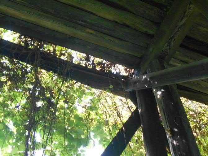


January 2019 – Marion, North Carolina


98
A-3
Photo 13 Spliced Cross Brace
Photo 14 Rotated Exterior Beam
Photo 15 Side Elevation
Photo 16 Failed Exterior Beam
Photo 17 Typical Interior Bent Photo 18 Split Bent Cap
A-4
Photo 19 Bearing Pads at Concrete Bent Cap
Photo 20 Split Bent Cap
Photo 21 Failed Exterior Beam
Photo 22 Typical Cross Bracing
Photo 23 Typical Pile Modification
Photo 24 Failed Exterior Beam
January 2019 – Marion, North Carolina


January
99
Peavine Trail Trestle Feasibility Study (EB-5542)
A-5
Photo 25 Damaged Interior Beams
Photo 26 Typical Pile Modification
Photo 27 Damaged Interior Beam
Photo 28 Interior Beam Decay
Photo 29
Damaged Interior Beam
Photo 30 Rotated Exterior Beam
Peavine Trail Trestle Feasibility Study (EB-5542)
2019 – Marion, North Carolina
A-6
Photo 31 North Trestle One Approach
Photo 32 Looking South on Top of Trestle One
Photo 33 Typical Vegetation on Trestle Deck
Photo 34 Rotated Exterior Beam from Above
Photo 35 Tree Growing on Trestle One Deck
Photo 36 Trestle One Deck
Peavine Trail Trestle Feasibility Study (EB-5542)
January 2019 – Marion, North Carolina
Peavine Trail Trestle Feasibility Study (EB-5542)


January 2019 – Marion, North Carolina


100
A-7
Photo Documentation Trestle Two:
Photo 37 Trestle Two – General Elevation
Photo 38 Trestle Two Deck
Photo 39 Trestle Two South Approach
Photo 40 End Bent Backwall Decay
Photo 41 Failed Exterior Beam
Photo 42 Typical End Bent Backwall Elevation
A-8
Photo 43 Damaged Timber Pile
Photo 44 Damaged Timber Cap
Photo 45 Typical Timber Pile
Photo 46 Exterior Beam Decay
Photo 47 Tree Growing Under Trestle Two
Photo 48 Completely Failed Exterior Beam
January 2019 – Marion, North Carolina
January 2019 – Marion, North Carolina


101
Peavine Trail Trestle Feasibility Study (EB-5542)
A-9
Photo 49 Completely Failed Exterior Beam
Photo 50 Typical Interior Bent
Photo 51 Typical Interior Beams
Photo 52 Tree Growing from Timber Cap
Photo 53 Looking Upstream
Photo 54 Looking Downstream
Peavine Trail Trestle Feasibility Study (EB-5542)
A-10
Photo 55 Stream Bank Scour
Photo 56 Stream Bank Scour
Photo 57 Tire Imbedded into Stream Bank
Photo 58 Split Cross Brace Member
Photo 59 Section Loss in Two Timber Piles
Photo 60 Damage from Falling Tree
Appendix B - Opinion of Probable Construction Cost (OPCC)


Peavine Trail Trestle Feasibility Study (EB-5542)
January 2019 – Marion, North Carolina

Appendix B
Opinion of Probable Construction Costs (Repurpose or Rebuild Trestles)
102
Trestle One Selective Demolition of Existing Structure and Debris Removal 1LS$100,000.00$100,000 Timber Decking 1LS$11,850.00$11,850 Replace Deteriorating Timber Beams1 1LS$25,600.00$25,600 Replace Deteriorating Timber Caps 1LS$13,800.00$13,800 Replace Deteriorating Timber Backwalls 1LS$7,400.00$7,400 Railing 493LF$75.00$36,975 Repair Existing Piles with Pile Jackets 80LF$600.00$48,000 Stabilize Stream Bank w/ Riprap2 0TON$65.00 $0 Powerwash Entire Structure & Apply Preservative Treatment to Timber Members 7,728SF $2.00$15,456 Contingency (10% of cost) 1LS$25,909.00$25,909 Trestle Two Selective Demolition of Existing Structure and Debris Removal 1LS$75,000.00$75,000 Timber Decking 1LS$7,410.00$7,410 Replace Deteriorating Timber Beams3 1LS$9,600.00$9,600 Replace Deteriorating Timber Caps 1LS$9,200.00$9,200 Replace Deteriorating Timber Backwalls 1LS$7,400.00$7,400 Railing 308LF$75.00$23,100 Repair Existing Piles with Pile Jackets 70LF$600.00$42,000 Stabilize Stream Bank w/ Riprap 16TON$65.00$1,040 Powerwash Entire Structure & Apply Preservative Treatment to Timber Members 4,347SF $2.00$8,694 Contingency (10% of cost) 1LS$18,345.00$18,345 Sub-Total Repair Items $486,779 Engineering Costs Design Costs (15% of Construction Cost)4 1LS$46,767.00 $46,767 $533,546 Footnotes 1 It is assumed that approximately 25% of the beams of Trestle One will need to be replaced 2 At this time, riprap is not necessary at Trestle One.
It is assumed that approximately 15% of the beams of Trestle Two will need to be replaced
Engineering costs are included for estimating purposes only are not to be considered final nor negotiated. 5 Total Estimated Cost is for structures items only. Estimated Cost Option One - Timber Decking Repair Items QuantityUnit Cost Total Estimated Cost5 = B-1
3
4
Appendix B - Opinion of Probable Construction Cost (OPCC)


Appendix B - Opinion of Probable
Cost (OPCC)
103
Trestle One Selective Demolition of Existing Structure and Debris Removal 1LS$100,000.00$100,000 Concrete Decking 3,450SF$15.00$51,744 Replace Deteriorating Timber Beams1 1LS$25,600.00$25,600 Replace Deteriorating Timber Caps 1LS$13,800.00$13,800 Replace Deteriorating Timber Backwalls 1LS$7,400.00$7,400 Railing 493LF$75.00$36,975 Repair Existing Piles with Pile Jackets 80LF$600.00$48,000 Stabilize Stream Bank w/ Riprap2 0TON$0.00 $0 Powerwash Entire Structure & Apply Preservative Treatment to Timber Members 7,728SF $2.00$15,456 Contingency (10% of cost) 1LS$29,898.00$29,898 Trestle Two Selective Demolition of Existing Structure and Debris Removal 1LS$75,000.00$75,000 Concrete Decking 1,940SF$15.00$29,106 Replace Deteriorating Timber Beams3 1LS$9,600.00$9,600 Replace Deteriorating Timber Caps 1LS$9,200.00$9,200 Replace Deteriorating Timber Backwalls 1LS$7,400.00$7,400 Railing 308LF$75.00$23,100 Repair Existing Piles with Pile Jackets 70LF$600.00$42,000 Stabilize Stream Bank w/ Riprap 16TON$65.00$1,040 Powerwash Entire Structure & Apply Preservative Treatment to Timber Members 4,347SF $2.00$8,694 Contingency (10% of cost) 1LS$20,514.00$20,514 Sub-Total Repair Items $554,527 Engineering Costs Design Costs (15% of Construction Cost)4 1LS$56,930.00 $56,930 $611,457 Footnotes 1 It is assumed that approximately 25% of the beams of Trestle One will need to be replaced 2 At this time, riprap is not necessary at Trestle One. 3 It is assumed that approximately 15% of the beams of Trestle Two will need to be replaced 4 Engineering costs are included for estimating purposes only are not to be considered final nor negotiated. 5 Total Estimated Cost is for structures items only. Total Estimated Cost5 = Estimated Cost Option One - Concrete Decking Repair Items QuantityUnit Cost B-2
Trestle One Demolition of Existing Structure 1LS$150,000.00$150,000 New Trestle Structure 1LS$276,000.00$276,000 Trestle Two Demolition of Existing Structure 1LS$110,000.00$110,000 New Trestle Structure 1LS$156,000.00$156,000 Sub-Total Replacement Items $692,000 Engineering Costs Design Costs (15% of Construction Cost)1 1LS$64,800.00$64,800 $756,800 Footnotes 1 Engineering costs are included for estimating purposes only are not to be considered final nor negotiated. 2 Total Estimated Cost is for structures items only. Estimated Cost Option Two - Timber Decking Repair Items QuantityUnit Cost Total Estimated Cost2 = B-3
Construction
Appendix B - Opinion of Probable Construction Cost (OPCC)
Peavine Trail Trestle Feasibility Study (EB-5542)
January 2019 – Marion, North Carolina
Appendix C
Trail Realignment Exhibits & Opinion of Probable Construction Costs
104
Trestle One Demolition of Existing Structure 1LS$150,000.00$150,000 New Trestle Structure 1LS$317,400.00$317,400 Trestle Two Demolition of Existing Structure 1LS$110,000.00$110,000 New Trestle Structure 1LS$179,400.00$179,400 Sub-Total Repair Items $756,800 Engineering Costs Design Costs (15% of Construction Cost)2 1LS$74,520.00$74,520 $831,320 Footnotes 1 Engineering costs are included for estimating purposes only are not to be considered final nor negotiated. 2 Total Estimated Cost is for structures items only. Total Estimated Cost2 = Option Two - Concrete Decking Repair Items QuantityUnit Cost Estimated Cost B-4
Marion Peavine Bridge Study


ENGINEER'S OPINION OF PROBABLE COST OF CONSTRUCTION - Planning
SUBTOTAL $293,685.00
CONTINGENCY @ $73,421.25
1. Cost opinion does not include costs for easement or ROW acquisition.
2. Cost opinion does not include engineering, geotech, design survey, or construction administration.
3. Cost opinion does not include cost for private utility relocations.
4. Unit costs used in this cost opinion are representative of typical market costs as best known to the Consultant as of the date of this estimate, and do not account for inflationary cost escalation.
5. Quantities used in this cost opinion are approximations based Planning Level Concepts by Kimley-Horn and are subject to revision prior to design/bid.

6. The Engineer has no control over the cost of labor, materials, or equipment, or over the Contractor's methods of determining prices or over competitive bidding or market conditions. Opinions of probable costs, as provided here, are made on the basis of the Engineer's experience and qualifications and represent the Engineer's judgment as a design professional familiar with the construction industry. The Engineer cannot and does not guarantee that proposals, bids, or actual construction costs will not vary from opinions of probable cost prepared for the Owner.
K:\CHL_PRJ\011036485 Marion Peavine Bridge Study\03_CALCULATIONS\OPCC\North Bridge\Marion Feasibility Study OPCC North Bridge.xlsm 1 of 1

105 DATE: 1-9-2019 NC LICENSE #F-0102 CHARLOTTE, NORTH CAROLINA 28202 MARION PEAVINE BRIDGE STUDY - NORTH BRIDGE PLAN AND PROFILE NORTH CL 1 1 2.0% 2.0% 2' EXISTING GROUND 2.0% 2 3 TYPICAL SECTION Prepared By: JMR Date: 1/7/2019 Checked By: AJH Date: KHA Project No: 011036485 Section Item Code Quantity Unit Unit Price Cost 800 10800.000 1 LS 26,700.00 $ 26,700.00 $ 200 10200.000 0.6 AC 10,000.00 $ 6,000.00 $ 225 10225.000 800 CY 6.00 $ 4,800.00 $ SP 81436.000 120 SY 2.50 $ 300.00 $ 453 10453.000 4000 SF 40.00 $ 160,000.00 $ 500 10500.001 1600 SY 2.50 $ 4,000.00 $ 520 10520.000 455 TN 37.00 $ 16,835.00 $ 610 10610.451 140 TN 90.00 $ 12,600.00 $ SP 80010.000 200 LF 60.00 $ 12,000.00 $ 876 10876.503 200 SY 6.00 $ 1,200.00 $ SP 81170.000 1 LS 15,000.00 $ 15,000.00 $ SP 30 LF 500.00 $ 15,000.00 $ 1 LS 13,000.00 $ 13,000.00 $ 25% SAY Notes: CONSTRUCTION COST $368,000
Drainage Boardwalk Erosion Control Geotextile for Drainage Safety Rail, Metal CLDS 50.04 Asphalt Concrete Surface Course, Type S 9.5C Fine Grading Aggregate Base Course Wall, Gravity Retaining Biaxial Geogrid Supplementary Clearing and Grubbing Unclassified Excavation Mobilization Peavine Trail North Trestle Item Description Project Description: 8' Greenway Around Trestle 1 (North Trestle) Client: NCDOT Client Project No.
Project Location: Marion, NC
ENGINEER'S
Marion
$58,936.00
@ $14,734.00

Cost opinion does not include engineering, geotech, design survey, or construction administration.

3. Cost opinion does not include cost for private utility relocations.
4. Unit costs used in this cost opinion are representative of typical market costs as best known to the Consultant as of the date of this estimate, and do not account for inflationary cost escalation.


5. Quantities used in this cost opinion are approximations based Planning Level Concepts by Kimley-Horn and are subject to revision prior to design/bid.

6. The Engineer has no control over the cost of labor, materials, or equipment, or over the Contractor's methods of determining prices or over competitive bidding or market conditions. Opinions of probable costs, as provided here, are made on the basis of the Engineer's experience and qualifications and represent the Engineer's judgment as a design professional familiar with the construction industry. The Engineer cannot and does not guarantee that proposals, bids, or actual construction costs will not vary from opinions of probable cost prepared for the Owner.
K:\CHL_PRJ\011036485 Marion Peavine Bridge Study\03_CALCULATIONS\OPCC\South Bridge\Marion Feasibility Study OPCC South Bridge.xlsm 1 of 1

106 DATE: 1-9-2019 NO MARION PEAVINE BRIDGE STUDY - SOUTH BRIDGE PLAN AND PROFILE CL 2.0% 1 PGL 2.0% 2.0% EXISTING 2.0% EXISTING GROUND 21 TYPICAL SECTION Prepared By: JMR Date: 1/7/2019 Checked By: AJH Date: KHA Project No: 011036485 Section Item Code Quantity Unit Unit Price Cost 800 10800.000 1 LS 5,360.00 $ 5,360.00 $ 200 10200.000 0.6 AC 10,000.00 $ 6,000.00 $ 225 10225.000 700 CY 6.00 $ 4,200.00 $ SP 81436.000 120 SY 2.50 $ 300.00 $ 500 10500.001 630 SY 2.50 $ 1,575.00 $ 520 10520.000 173 TN 37.00 $ 6,401.00 $ 610 10610.451 10 TN 90.00 $ 900.00 $ 876 10876.503 200 SY 6.00 $ 1,200.00 $ SP 81170.000 1 LS 15,000.00 $ 15,000.00 $ SP 30 LF 500.00 $ 15,000.00 $ 1 LS 3,000.00 $ 3,000.00 $ 25% SAY Notes: CONSTRUCTION COST $74,000 1. Cost opinion does not include costs for easement or ROW acquisition. 2.
SUBTOTAL
CONTINGENCY
Drainage Boardwalk Erosion Control Geotextile for Drainage Asphalt Concrete Surface Course, Type S 9.5C Fine Grading Aggregate Base Course Biaxial Geogrid Supplementary Clearing and Grubbing Unclassified Excavation Mobilization Peavine Trail South Trestle Item Description Project Description: 8' Greenway Around Trestle 2 (South Trestle) Client: NCDOT Client Project No.
OPINION OF PROBABLE COST OF CONSTRUCTION - Planning
Project Location: Marion, NC
Peavine Bridge Study

107 AppendixE : Corridor Deed


108


109


