

Wilson c r EE k a ction Plan:
Ex E cutiv E s ummary
Produced For:
Carolina Land and Lakes
Resource Conservation and Development
United States Forest Service
Pisgah National Forest
Grandfather Ranger District

Produced By:
Destination by Design

Project Oversight Committee:
• Carolina Land & Lakes -
Resource Conservation and Development
• US Forest Service
• American Whitewater
• A Clean Wilson Creek
• Caldwell County Chamber of Commerce
• Caldwell County Planning Department
• Foothills Conservancy of North Carolina
• G5 Trail Collective
• Latinos Aventureros en las Carolinas
• North Carolina Wildlife Resources Commission
• Northwest NC Mountain Bike Alliance
• Trout Unlimited
• Wild South
i ntroduction
The Wilson Creek Action Plan provides a vision for future outdoor recreation infrastructure development along Wilson Creek. The project study area, located in Caldwell County, North Carolina, stretches approximately nine miles in length and includes the Wilson Creek Wild and Scenic River corridor from Adako Road to NC 90 at Mortimer. Carolina Land and Lakes Resource Conservation and Development (RC&D), in cooperation with the United States Forest Service (USFS), is funding and leading the effort.
PLAN GOALS
ANALYSIS: Conduct a thorough assessment of the study area to evaluate significant opportunities and constraints for outdoor recreation infrastructure development.
COMMUNITY: Engage stakeholders, government and community leaders, and the public to encourage collaborative efforts and promote a shared vision that will support organizational and community goals.
EXPERIENCE: Create an environmentally, socially, economically, and managerially sustainable experience that provides equitable access for all.
EDUCATION: Encourage advocacy, stewardship, and appropriate use for protection of and access to the natural environment.
PUBLIC SAFETY: Guide and disperse use through infrastructure development that provides a safe experience and adequate access for emergency response.
BACKGROUND
Wilson Creek stretches approximately 23 miles from the mountains to the foothills of western North Carolina. The river, from its headwaters in Avery County to its confluence with the Johns River in Caldwell County, was added to the National Wild and Scenic River System on August 18, 2000.
Foothills Conservancy of North Carolina (FCNC) and other partners with interests in the river corridor have worked together to protect lands and educate the public about the natural resources found along Wilson Creek. Through grant funding and generous private landowner donations, FCNC has acquired over 1,500 acres of protected land in the last 20 years that links Pisgah National Forest to the Wilson Creek corridor.
With the addition of protected lands and increased accessibility to Wilson Creek, recreational use in the corridor has steadily increased. The number of visitors and vehicles consistently surpasses the capacity of existing parking areas and other outdoor recreation infrastructure within the corridor. The significant amount of use creates a number of challenges for visitor and natural resource management.

c ommunity Engag E m E nt
Significant efforts were made to introduce the project to the public and engage community members and stakeholders.
WEBSITE & SURVEY
A project specific website, hosted by G5 Trail Collective, was developed to inform the public and stakeholders about the Action Plan. A project fact sheet provided information about the planning effort in English and Spanish. The website provided a link to a community survey, which received 627 comments. Approximately 65% of respondents were local (Lenoir, Morganton, Granite Falls, Linville, Boone, and Marion). The remaining 35% of responses came from other communities in the Mountains and Piedmont.
PROJECT OVERSIGHT COMMITTEE
Members of the Project Oversight Committee guided the planning process and included representatives from the US Forest Service, Carolina Land and Lakes Resource Conservation and Development, A Clean Wilson Creek, American Whitewater, Caldwell County Chamber of Commerce, Caldwell County Planning Department, Foothills Conservancy of North Carolina, G5 Trail Collective, Latinos Aventureros en las Carolinas, North Carolina Wildlife Resources Commission, Northwest North Carolina Mountain Bike Alliance, Trout Unlimited, and Wild South.
STAKEHOLDER GROUPS
Project partners also conducted meetings with three key stakeholder groups: NC Wildlife Resources Commissions, local Law Enforcement and Emergency Medical Services, and landowners that lived within the Wilson Creek corridor. Key takeaways are listed below.
• Recreation in the headwaters and upper corridor should focus on dispersed uses like hiking, mountain biking, and fishing.
• Infrastructure that provides turn-around areas for emergency vehicles is needed.
• Access and parking areas should be identified and signed.
• Litter pick-up, collection, and human waste management are significant issues.
• Additional road maintenance is needed.
• Rule and regulation enforcement responsibilities by various agency Law Enforcement officers is unclear to the public.
• Concerns about long-term sustainability of current management, use, and environmental protection exist.

gE n E ral c orridor
General corridor recommendations address improvements for visitor orientation, experience, and safety. Each public land manager will determine which recommendations can be implemented on their lands based on agency policy and guidelines.
Visitor Orientation
• Offer regional wayfinding information at key visitor orientation areas and information specific to the Wilson Creek corridor at trailhead kiosks.
• Clearly define public land boundaries along Brown Mountain Beach Road.
Visitor Experience
• Concentrate infrastructure development into “focus areas”.
• Disperse focus areas along the length of the study area.
• Provide parking, vault toilets, and bear-proof trash cans at each focus area in the USFS day-use area to address waste management.
• Follow USFS facility design guidelines to minimize visual impacts to visitors on Wilson Creek and Brown Mountain Beach Road.
• Explore trail connectivity between focus areas to provide visitors with multiple options to access the river and adjacent public lands.
Visitor Safety
• Use consistent and standard design specifications for focus areas.
• Define each parking space (10 feet X 22 feet) with wheel stops.
• Include signage with site name and allowable use symbols at each focus area.
• Maintain a consistent road width (20 feet) for the length of the corridor
• Provide reserved parking spaces and turn-around areas for law enforcement and emergency management that is physically separated from visitor parking.
• Eliminate parking in non-designated areas using boulders, guardrails, and road realignment.
• Advocate for a lower speed limit.
AVERY COUNTY CALDWELL COUNTY
Points of Interest
Existing Day Use Areas
USFS Day Use Area
Wild & Scenic River Corridor
NCWRC Pisgah Game
Land-Lutz Tract
Pisgah National Forest
Private Land
Paved Roads
Unpaved

The Old Mill
Harper Creek trailhead
mortimer campground
Wilson Creek Visitor Center
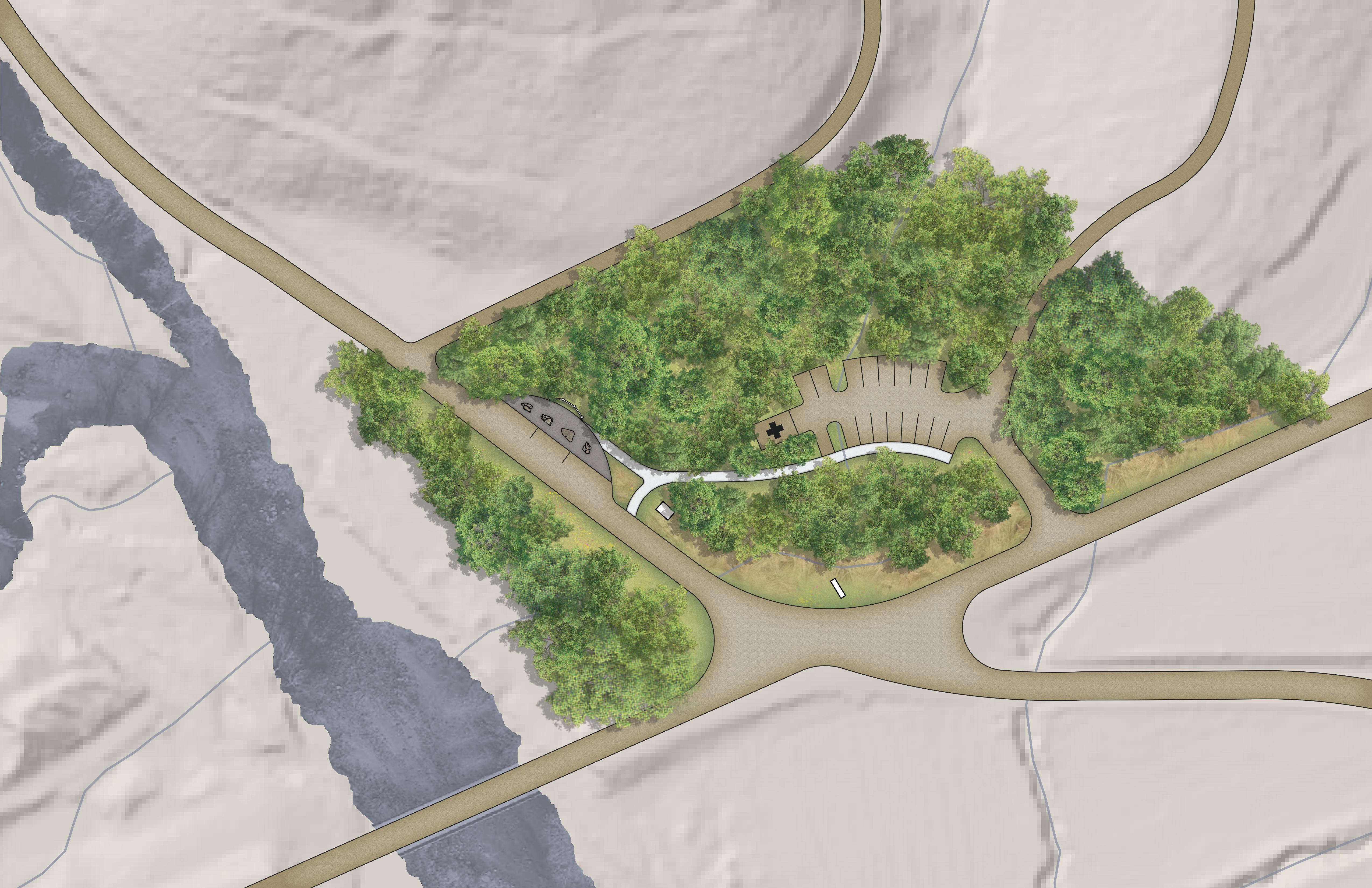
sitE sPEciFic rEcommEndations
ite specific recommendations highlight outdoor recreation infrastructure development for specific focus areas within the Wilson Creek corridor. The matrix below provides the responsible land manager, site classification, existing and proposed amenities, and number of existing parking spaces for each focus area. It also includes existing and proposed parking spaces and an estimate of probable cost. The project oversight committee determined implementation priority for each focus area.
Site plans for four high-priority focus areas are included after the matrix. Site plans for all focus areas can be found in the full plan document.
Focus Area 1: Adako
Focus Area 2: Lower Gorge
Focus Area 3: Bathtub
Focus Area 4: Middle Gorge
Existing
• Non-designated Parking
• Natural Surface Trail leading to Wilson Creek
Proposed
• Gateway Sign
• 3-Panel Informational Kiosk with Temporary Parking
• Emergency Management Staging Area/Recreational Use Parking
Existing
• Developed River Access (2)
• Restroom
• Bear-Proof Trash Cans
Proposed
• Changing Room
• Paddler Loading Zone
• Emergency Services Parking
Existing
• Dispersed River Access (2)
Proposed
• Restroom
• Changing Room
• Bear-Proof Trash Cans
• Emergency Services Parking
Existing
• Developed and Dispersed River Access
Proposed
• Restroom
• Bear-Proof Trash Cans
Planning Section 1: Planning Section 2 (Cont’d):
Planning Section 2 (Cont’d):
Focus Area 5: Thunderhole
Focus Area 6: Wilson Ridge
Focus Area 7: Lady on the Rock
Focus Area 8: Paddler Put In
Focus Area 9: Creekside
Existing
• Developed River Access
Proposed
• Dispersed Picnic Area
• Restroom
• Changing Room
• Bear-Proof Dumpster
Existing
• Trail Access
• Dispersed River Access
Proposed
• 1-Panel Kiosk
• Restroom
• Changing Room
• Bear-Proof Trash Cans
Existing
• Developed River Access
• Dispersed River Access (4)
Proposed
• ADA Viewing Platform
• ADA Riverside Parking
• Restroom
• Bear-Proof Trash Cans
• Emergency Services Parking
Existing
• Developed River Access
• Dispersed River Access (3)
Proposed
• Paddler Loading/Unloading Zone
• Restroom
• Changing Room
• Bear-Proof Trash Can
• Emergency Services Parking
Existing
• Dispersed River Access
Proposed
• Dispersed Picnic Area
• Restroom
• Changing Room
• Bear-Proof Dumpster
$447,938 $487,494 $540,417 $402,380 $550,783
Planning Section 2 (Cont’d):
Existing
• Dispersed River Access
Proposed
• Developed ADA River Access
• Picnic Shelters (2)
Focus Area 10: Deerhorn Caldwell County
Focus Area 11: Confluence
Focus Area 12: Craig Creek USFS USFS
• Dispersed Picnic Area
• Event Lawn
• Restroom
• Changing Room
• Bear-Proof Trash Cans and Dumpster
• Emergency Services Parking
• Road Realignment
Proposed
• Dispersed Picnic Area
• Developed ADA River Access
• Dispersed River Access
• Restroom
• Changing Room
• Bear-Proof Trash Cans and Dumpster
Existing
• Dispersed River Access
Proposed
• 3-Panel Informational Kiosk With Temporary Parking
• Bear-Proof Dumpster
• Emergency Management Staging Area/Parking
$847,453 $143,493 $2,364,101 Total Cost: $7,545,186
* Existing parking totals include developed and designated dispersed parking areas as outlined in the Wilson Creek Day Use Area Access and Parking Assessment produced by the USDA Forest Service Grandfather Ranger District in February 2019.
** These recommendations don’t constitute a commitment from the NCWRC. All development must be consistent with conservation dedication agreements and approved by the NCWRC and NC Natural Heritage Program.
Planning Section 3:
Focus Area 13: Wilson Creek Visitor Center
Focus Area 15: Harper
Area 16: The Old
Focus Area 17:
Existing
• Visitor Center Building
• Picnic Shelters (2)
• Small Parking Areas (2)
• Informational Kiosks (2)
• Picnic Area
• Pine Ridge Trail Access
• Event Lawn
Proposed
• Outside Restroom
• Pine Ridge Trail Trailhead Enhancement
• Amphitheater
• Bear-Proof Dumpster
• Parking Expansion
Proposed
• Informational Kiosk
• Parking
Existing
• Small Parking Area
• Harper Creek Trail Trailhead Sign
Proposed
• 1-Panel Kiosk
• Angler Access
• Parking Expansion
Existing
• Angler Access
• Bear-Proof Trash Cans (4)
• Bear-Proof Dumpster
Proposed
*Explore development of additional recreational amenities with a willing government or non-profit organization partner.
Existing
• Small Parking Area (3)
• Angler Access
• Town Of Mortimer Flagpole and Monument
Proposed
• Gateway Sign
• 3-Panel Informational Kiosk With Temporary Parking (3)
• Interpretive Sign
* Parking totals and estimates of probable cost were not determined for planning sections 3 and 4 due to their location outside the USFS day-use area.
** These recommendations don’t constitute a commitment from the NCWRC. All development must be consistent with conservation dedication agreements and approved by the NCWRC and NC Natural Heritage Program.
Focus Area 14: Emerald Pool
Creek
Focus
Mill
Mortimer
Planning Section 4:


playmore
parking (25)
• 24 typical • 1 ada

access
ada riverside parking
ada viewing platform (12’ x 12’)
single vault restroom (11’ x 17’) & TRASH
le/ems parking (30’ x 40’)

x 17’), changing room (6’ x 6’), & trash


(20’ x 30’)


i m P l E m E ntation
The Wilson Creek Action Plan provides a vision for future outdoor recreation infrastructure development along Wilson Creek. The completion of the planning process represents an important first step that should be built on to accomplish implementation. Project partners should continue to engage stakeholder groups, government leaders and staff, affected landowners, and community members, providing regular updates on implementation progress.
TIMELINE:
FEbruary 2019
USFS staff completes the Wilson Creek Day Use Area Access and Parking Assessment.
January - sEPtEmbEr 2024
Project partners work with a consultant team to complete the Wilson Creek Action Plan.
sPring 2025
DOT implements Brown Mountain Beach Road improvements and widening.
2026
USFS begins construction on high priority focus areas.
2025
USFS begins NEPA analysis and engineering.

