
15 minute read
Lungo la ‘via Maris’


“The sea coast of Palestine may be called one of the curiosities of the world. Its long, pitiless sweep from the Egyptian frontier to Carmel is familiar to all to whom this land is holy, and its chief characteristic is plain, so to speak, upon its face. It has no natural harbour On such a coast we have to ask ourselves why any one point rather than another should be selected as a port, and to this we shall probably find a ready answer. Primitive man in his search for fresh water over the parched plains of Philistia found it sometimes where he least expected it, on the seashore. One such oasis amongst the sand-dunes stands on the very brink of the Mediterranean some 12 miles north of Gaza. Its wells to this day can be counted by scores. Here you will find palms and hedgerows, fields green with cultivation and bounteous with grateful shade.
This Paradise is Askalon.”
(Phythian-Adams, 1921)
Il Mar Mediterraneo è quel vuoto tra i pieni che si pone come ponte di connessione tra popoli diversi dove lì si sono incontrati e scontrati, generando culture eterogenee ma caratterizzate dalla loro dimensione corale prettamente mediterranea. Diversi Topoi si riscontrano nelle città appartenenti a questa realtà della culla dei popoli, descritta anche dal geografo greco Strabone, nel I secolo a.C.. Nel suo trattato, parlando del Mediterraneo, egli scrive: “Da questo punto di vista il ‘nostro mare’ possiede una grande superiorità ed è dunque seguendolo che inizieremo il giro del mondo”.
Il Mar Mediterraneo è perciò quella forte quinta scenica che ha caratterizzato le radici della città di Ashkelon e ne ha tenacemente influenzato il suo sviluppo.
Civiltà di mare
Ashkelon è una delle antiche città portuali che si inserisce in questa realtà mediterranea, ed è situata nella striscia costiera israeliana tra Gerusalemme e Gaza precisamente lungo la via
Maris. Antica strada commerciale parallela al mare, la via Maris collegava Alessandria con Damasco attraversando la costa palestinese e passando per Gaza, Ashkelon, Ashdod e Dor.
Le sue origini risalgono al XX secolo a.C. con l’insediamento dei Cananei dopo i quali si susseguirono popolazioni eterogenee provenienti dal Medio Oriente e dall’Occidente. Nel XIV sec a.C. gli Egizi governano la città che, successivamente, raggiunge importanza in virtù del porto con i Filistei. Nel IX sec. a.C. diventa perciò brama di molte popolazioni tra cui gli Assiri, i Babilonesi, i Persiani per poi diventare una colonia dei Greci nel 332 a.C. con la conquista di Alessandro Magno. Maccabei e Asmonei li succedono fino all’arrivo dei Romani nel I sec a.C. con la costruzione delle mura sugli spalti di origine cananea. Il culmine della prosperità di Ashkelon si ha nel periodo bizantino, in contemporanea con la sua conversione al cristianesimo (IV-VII sec d.C), diventando un potente centro commerciale con l’esportazione di grano e vini.
The Mediterranean Sea is that empty space between fullnesses, being a a connecting bridge between different populations where they have met and clashed. It generates heterogeneous cultures, but all characterised by their typically Mediterranean choral dimension. Varied Topoi can be found in different cities belonging to this cradle of peoples, also described by the Greek geographer Strabone, in the 1st century BC. In his treatise he wrote, speaking of the Mediterranean Sea : “From this point of view, ‘our sea’ possesses great superiority and it is therefore by following it that we will begin our tour of the world “.
The Mediterranean is therefore the striking scenic backdrop that characterized the roots of the city of Ashkelon and tenaciously influenced its development.
Civilisation of the sea
Ashkelon is one of the ancient port cities in the Mediterranean Sea, and it is located in the Israeli coastal strip between Jerusalem and Gaza precisely along the Via Maris. An ancient trade route parallel to the sea, the Via Maris , connected Alexandria with Damascus by crossing the Palestinian coast and passing through Gaza, Ashkelon, Ashdod and Dor.
Its origins date back to the 20th century B.C. with the settlement of the Canaanites, after whom heterogeneous populations from the Middle East and the West followed. In the 14th century B.C., the Egyptians ruled the city, which later gained importance due to its port with the Philistines . Therefore in the 9th century B.C., it became the coveted city of many populations, including the Assyrians, Babylonians and Persians, before becoming a colony of the Greeks in 332 B.C. with the conquest of Alexander the Great.
The Maccabees and Hasmoneans succeeded them until the arrival of the Romans in the 1st century B.C. with the construction of the walls on the Canaanite ramparts. The peak of Ashkelon’s prosperity occurred in the Byzantine period, at the same time as its conversion to Christianity (4th-7th century AD), when it became a powerful trading centre with the export of grain and wine.
Distrutta e successivamente ricostruita fortificata con gli Arabi, diventa mussulmana per essere poi terra cristiana con la spedizione dei Crociati per liberare la Terra Santa nel XII sec d.C.
Nel 1187 Salah al-Din (Saladino) sconfigge i crociati e conquista le roccaforti. Nel 1191 il suo esercito viene sconfitto nella battaglia di Arsuf (Apollonia) da Riccardo Cuor di Leone, ma Saladino riesce ugualmente a demolire le fortificazioni di Ashkelon prima che i Crociati entrino in città.

Nel 1240 viene nuovamente fortificata da Riccardo I di Cornovaglia, ma nel 1270 le forze musulmane guidate dal sultano Bybars conquistano e distruggono definitivamente la città portuale. Dopo tale evento, verrà abbandonata per poi svilupparsi all’esterno delle mura disposte a semicerchio verso il mare. Nel corso dei secoli la popolazione, e di conseguenza la città, si è sviluppata sempre di più nell’entroterra allontanandosi dal mare fino a perdere quell’antico importante ruolo di città portuale che aveva portato all’egemonia economica e commerciale.
Destroyed and later rebuilt fortified by the Arabs, it became Muslim and then Christian land with the Crusade expedition to liberate the Holy Land in the 12th century AD. In 1187 Salah al-Din (Saladin) defeated the Crusaders and conquered the strongholds. In 1191 his army was defeated at the Battle of Arsuf (Apollonia) by Richard the Lionheart, but Saladin still managed to demolish the fortifications of Ashkelon before the Crusaders entered the city. In 1240 it was fortified again by Richard I of Cornwall, but in 1270 Muslim forces led by Sultan Bybars conquered and permanently destroyed the port city. After this event, it was abandoned and developed outside the walls arranged in a semicircle towards the sea.
Over the centuries, the population, and consequently the city, continued to develop inland, moving away from the sea, until it lost its former important role as a port city, which had led to economic and commercial hegemony.
Missioni archeologiche
Le rovine dell’antica città di Ashkelon vengono riportate alla luce solamente nel periodo ottomano (XVI-XX sec d.C.), inizialmente per opera della missione archeologica di Lady Hester Stanhope del 1815, succeduta poi dalle varie spedizioni del XX secolo. Tra le missioni di maggior rilievo è opportuno citare quelle di Leon Levy (1985 –2006), in quanto hanno apportato una catalogazione delle rovine ed un’accurata descrizione storica, morfologica e archeologica della città.
Da tali missioni archeologiche, è accresciuto l’interesse per l’antica città costiera da parte delle istituzioni israeliani, aumentando le attività di ricerca e aprendo il sito ai locali e turisti. Allo stesso tempo è aumentata anche la necessità di salvaguardia dei ritrova- menti derivati dagli scavi, oltre a proseguire l’attività archeologica per poter continuare a dar voce alla sua storia.
Da questa crescente necessità, nel 1964 nasce il parco archeologico di Ashkelon con il nome di National Park Authority
Archeological expeditions
The ruins of the ancient city of Ashkelon were only brought to light in the Ottoman period (16th - 20th century AD), initially by Lady Hester Stanhope’s archaeological mission in 1815, followed by various expeditions in the 20th century. Among the most important missions those of Leon Levy (1985 - 2006) should be mentioned, as they catalogued the ruins and provided an accurate historical, morphological and archaeological description of the city.

From these archaeological missions, the interest in the ancient coastal city on the part of Israeli institutions has grown, increasing research activities and opening the site to locals and tourists. At the same time the need to safeguard the findings from the exca- vations has also increased, as well as to continue archaeological work continues in order to keep giving voice to its history.
From this growing need, the Ashkelon Archaeological Park was born in 1964 as the National Park Authority.
Matrice Mediterranea
Estendendosi nell’entroterra, l’originaria Ashkelon assume una configurazione a semicerchio, il cui diametro corrisponde alla fascia a contatto con il mare mentre l’arco è definito dalle antiche fortificazioni che seguono la conformazione del terreno caratterizzata in alcune aree dalla presenza delle creste di kurkar. Queste dune di arenaria locale sono state create da sabbie di epoca preistorica provenenti da quello che poi diventerà il Delta del Nilo. Tali dune di sabbia hanno successivamente sepolto il canale fluviale preistorico che, partendo dalla sua falda acquifera delle colline ad est, trasporta acqua dolce fino alle spiagge di Ashkelon.
La pressione dell’acqua dolce sotterranea che scorre da est impedisce al mare di rendere le acque sotterranee locali salmastre, come altrimenti accadrebbe lungo la riva. Il motivo della presenza di numerosi antichi pozzi che sono stati scoperti nell’area dell’antica città è perciò chiaro. Sfruttano tale peculiarità arrivando fino a quella sorgente d’acqua dolce, così prossima al mare. La disponibilità di abbondante acqua fresca era tale da rendere Ashkelon una vera e propria oasi.
Lungo la cinta muraria a semicerchio, i cui resti sono ancora presenti, si dispongono le quattro porte della città : una di queste è la Porta di Gerusalemme (o Maggiore), chiamata così perché rivolta verso est, verso la Città Santa. La seconda è la Porta di Jaffa in direzione nord mentre a sud è presente la Porta di Gaza, entrambe rivolte verso le corrispondenti omonime città, entrambe collegate dalla via Maris
Si presume infine, che ci fosse anche il quarto accesso verso ovest, la cosiddetta Porta del Mare, ancora però oggetto di ricerca e discussione.
L’esatta posizione del porto difatti è ancora sconosciuta e probabilmente è variata nel corso dei secoli, ma nel muro sud-ovest a strapiombo sul mare sono presenti delle colonne di granito posizionate in orizzontale. Si suppone abbiano la funzione di rafforzare le pareti murarie dal momento in cui il porto ed il fronte mare hanno avuto un ruolo estremamente importante.
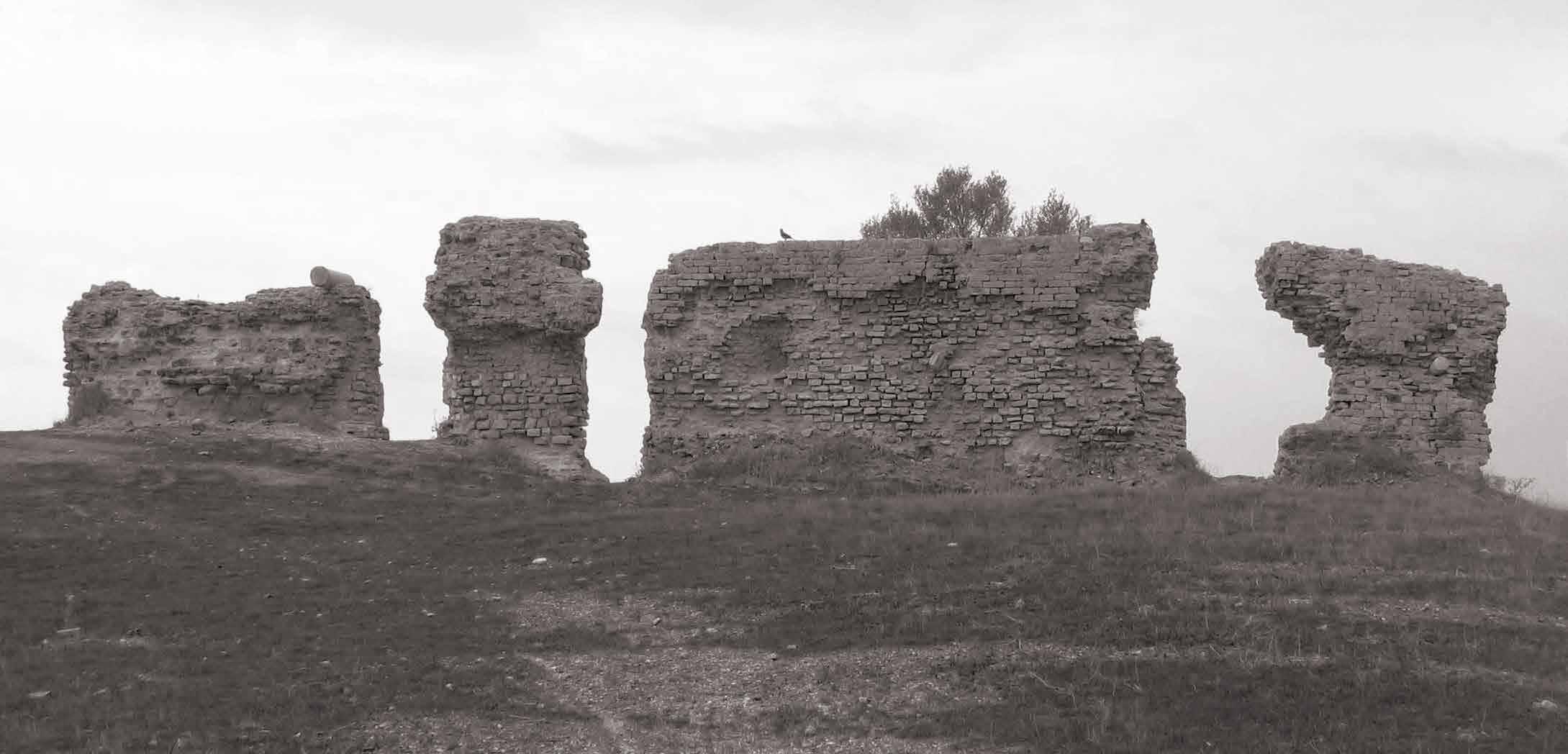
Oltre ai vari pozzi ed alcune parti della cinta muraria nel sito di Ashkelon, attualmente sono visibili resti archeologici ed architettonici presenti in maniera diffusa in tutta l’area, nella quale si possono identivifare due zone principali denominate North Tell e South Tell. Durante le spedizioni archeologiche il sito è stato ideologicamente diviso in aree di lato 100mx100m, permettendo una migliore localizzazione e catalogazione dei reperti. Tra i ritrovamenti arrivati fino ai nostri giorni emergono i resti della struttura colonnata di una Basilica, indicativamente al centro di tale griglia, ad est la Chiesa detta di S. Maria Viridis ed il Teatro di epoca romana, mentre ad ovest alcuni ruderi di ambienti voltati. L’immagine zenitale ha facilitato lo studio del tessuto urbano, del quale si può notare la somiglianza con l’impianto architettonico di Cesarea (Israele), anch’essa città portuale che si trova più a nord, a 42 km da Haifa, affacciandosi sul Mediterraneo. Le analogie tra queste due città si possono trovare già dalla cinta muraria dove è possi-
Mediterranean matrix
The original Ashkelon assumes a semicircle configuration extending inland, and its diameter corresponds to the belt in contact with the sea, while the arc is defined by the ancient fortifications that follow the conformation of the land, characterised in some areas by the presence of kurkar ridges. These dunes of local sandstone were created by prehistoric sands, from what later became the Nile Delta. At a later time, these sand dunes buried the prehistoric river channel that carries fresh water from its aquifer in the east ernhills to the beaches of Ashkelon. The pressure of fresh underground water flowing from the east prevents the sea from making the local groundwater brackish, as would otherwise happen along the shore. The reason why numerous ancient wells have been discovered in the area of the ancient city is therefore clear. They exploited this peculiarity by reaching that freshwater spring, so close to the sea. The availability of abundant fresh water was such that Ashkelon became a true oasis.
Along the semicircular city wall, whose remains are still present, are the four city gates: one of these is the Jerusalem Gate (or Major), so called because it faces east, towards the Holy City.
The second is the Jaffa Gate facing north, while to the south is the Gaza Gate, both facing the corresponding cities of the same name, both connected by the Via Maris. Finally, it is assumed that there was also a fourth access to the west, the so-called Porta del Mare (Sea Gate), which is still the subject of research and discussion. The exact position of the port is still unknown and has probably varied over the centuries. But, overhanging the sea in the south-west wall, there are some granite columns with a horizontal position. They are supposed to have the function of reinforcing the walls, since the port and the waterfront played an extremely important role.
In addition to the various wells and parts of the wall in the Ashkelon site, archaeological and architectural remains can currently be seen scattered throughout it. Two main areas called North Tell and South Tell can be identified. During archaeological expeditions, the site was ideologically divided into areas of 100mx100m, allowing for a better localisation and cataloguing of the finds.
Among the archeological ruins that have survived to the present day are the remains of the columned structure of a Basilica, approximately in the centre of this grid, in the eastern part of the Church of S. Maria Viridis and the Roman theatre, and in the west part some ruins of vaulted spaces.
The aerial photograph facilitated the study of the urban structure, in which it is possible to note the similarity with the architectural layout of Caesarea (Israel), also a port city located further north, 42 km from Haifa, overlooking bile notare in entrambe, la conformazione a semicerchio delle fortificazioni. Assumendo un’impostazione binata, raddoppiandone il tracciato. Un’area che viene identificata per il suo ruolo difensivo viene così definita, all’interno della quale vengono localizzate varie attività funzionali inserendo il teatro, lo stadio e l’anfiteatro. Più a nord di Cesarea precisamente nella città di Akko (Israele) si riscontra il medesimo impianto binato che ne determina al suo interno la presenza di un fossato.
Proseguendo questa lettura per analogie, possiamo arrivare a identificare quella matrice mediterranea secondo la quale il popolo romano organizzava il fronte mare nell’area mediterranea del Medio Oriente.
Confrontando tra loro Ashkelon e Cesarea si evince la dislocazione delle strutture pubbliche come la Basilica e l’area del Foro come fattore comune, seguendo l’orientamento cardo-decumano solo però nel caso della seconda località. Per quanto riguarda invece Ashkelon, la disposizione sembra discordare rispetto agli assi che sono stati identificati come Cardo e Decumano.
Lo sfarzo delle rovine e le imponenti fortificazioni ci lasciano intendere la posizione dell’antica Ashkelon come una città molto potente, ricchezza generata grazie alla strategica posizione sul Mar Mediterraneo, e quindi ad uno sviluppo commerciale molto potente, assieme ad un terreno estremamente fertile che ha permesso un’agricoltura abbondante.
La fertilità ed il prestigio economico per le attività mercantili della città si ritrovano nel suo nome, che riferendosi alla radice della parola shekel, indica l’unità di peso e l’antica e moderna valuta ufficiale israeliana. La medesima parola diventa identificazione dello scalogno, una delle varietà di allium, lì coltivato ed esportato in tutto il Medi- terraneo. Inoltre, altre piantagioni occupavano il terreno fertile di Ashkelon, tra cui gli ulivi, il fumento e molte piante medicinali e da frutto. Il clima è difatti ottimo per la cereagricoltura, frutticoltura e agrumicoltura.
La ricca vegetazione e l’affaccio sul Mar Mediterraneo garantivano l’indipendenza e l’egemonia della città nella pianura litorale palestinese.Secondo Claude Conder, uno degli autori della monumentale ottocentesca Survey of Western Palestine, che aveva calpestato la maggior parte del nazione: “Ascalon è uno dei luoghi più fertili della Palestina. Le grandi mura, che sono ben descritte da William di Tiro come un arco con la corda al mare, racchiude uno spazio di cinque ottavi di miglio a nord e sud, di tre ottavi di profondità.
Il tutto è pieno di ricchi giardini, e non meno di trentasette pozzi di acqua dolce esistono all’interno delle mura, mentre a nord, per quanto lontano come il villaggio, altri giardini e altri pozzi saranno trovati. L’intera stagione sembrava più avanzata in questo angolo riparato che sulla pianura più esposta. Le palme crescono in numero; i mandorli e limoni, il tamerice e il fico d’India, le olive e la vite, con ogni tipo di verdura e mais, già nella spiga, fioriscono in tutta l’estensione dei giardini all’inizio di aprile. Solo a sud le grandi onde di sabbia sempre invadente ha ora sormontato le fortificazioni e spazzò giardini un tempo fecondi, minaccioso in tempo per fare tutto un deserto sabbioso, a meno che non si trovino i mezzi per arrestarne il progresso.”
(Conder ,1875) the Mediterranean Sea. The similarities between these two cities can already be found in the city walls where it is possible to note in both the semicircular conformation of the fortifications. Doubling the line it takes a twin layout.
An area that is identified for its defensive role is thus defined, within which various functional activities are located by inserting the theatre, the stadium and the amphitheatre. More northerly of Caesarea, in the city of Akko (Israel), the same twin layout can be found. Which determines the presence of a moat within it.
Proceeding this analysis by analogy, we can identify that Mediterranean matrix, according to which the Roman people organised the seafront in the Mediterranean area of the Middle East.
Comparing Ashkelon and Caesarea shows the dislocation of public buildings such as the Basilica and the Forum area as a common factor, following the cardo-decuman orientation only in the case of the latter location. As for Ashkelon, on the other hand, the layout seems to deviate from the axes that have been identified as Cardo and Decumanus
The magnificence of the ruins and the massive fortifications suggest the position of ancient Ashkelon as a very powerful city, its prosperity generated by its strategic location on the Mediterranean Sea, and thus by a very powerful commercial development, combined with an extremely fertile soil that provided abundant agriculture. The fertility and economic prestige for the city’s mercantile activities are reflected in its name, which indicates the unit of weight and the ancient and modern official Israeli currency. Referring to the root of the word shekel
The same word became the identification of the shallot, one of the varieties of allium, cultivated there and ex- ported throughout the Mediterranean. Moreover other plantations filled Ashkelon’s fertile soil, including olive trees, wheat and many medicinal and fruit plants. In fact the climate is excellent for cereal, fruit and citrus cultivation.
The rich vegetation and the overlooking of the Mediterranean Sea guaranteed the city’s independence and hegemony in the Palestinian coastal plain. According to Claude Conder, one of the authors of the monumental nineteenth-century Survey of Western Palestine, who had travelled through most of the nation:
“Ascalon is one of the most fertile spots in Palestine. The great walls, which are well described by William of Tyre as a bow with the string to the sea, enclose a space of five-eighths of a mile north and south, by threeeighths deep. The whole is filled with rich gardens, and no less than thirty-seven wells of sweet water exist within the walls, whilst on the north, as far as the village, other gardens and more wells are to be found. The whole season seemed more advanced in this sheltered nook than on the more exposed plain. Palms grow in numbers; the almond and lemon-trees, the tamarisk and prickly pear, olives and vines, with every kind of vegetable and corn, already in the ear, are flourishing throughout the extent of the gardens early in April. Only on the south the great waves of ever-encroaching sand have now surmounted the fortifications and swept over gardens once fruitful, threatening in time to make all one sandy desert, unless means can be found to arrest its progress.”
(Conder, 1875)

Mappa di Madaba Madaba map


La storia della città di Ashkelon, determinata dalla molteplicità di interazioni culturali, è estremamente ricca di eventi e di popolazioni che si sono succedute ed influenzate a vicenda, determinando un tessuto urbano ed impianto architettonico specifico. Essendo dunque una città ricca di storia, un qualsiasi progetto nell’area più a diretto contatto con il suo passato non può astenersi dal confronto con l’antica Ashkelon.
La lettura storica, quella geografica ed archeologica forniscono alcune fonti scritte che spesso e volentieri non sono state troppo esaurienti in merito all’impostazione urbana. Tuttavia, il confronto con le raffigurazioni della città all’interno delle antiche carte è stato un’importante analisi che ha permesso una diversa interpretazione della conformazione di Ashkelon.
Due carte in particolare sono state prese come riferimento per metodo di indagine precedentemente descritto: la Tabula Peuntingeriana per il periodo romano, mentre durante il periodo medievale la Mappa di Madaba
La Mappa di Madaba è un frammento di un mosaico pavimentale risalente al VI sec d.C che si trova nella chiesa bizantina di San Giorgio, nella città giordana di Madaba. E’ una mappa del Medio Oriente che viene considerata una delle rappresentazioni più affidabili di


