1 minute read
Act One - Preston Cartographically I.II Site Attributes


The site is oriented north-south skewed slightly to the east in its diagonal. The urban density of the surrounding area decreases along this southern access meaning the rear of the site benefits from good access to daylight . However the southern aspect faces a multistorey car parking providing an eye sore at the ‘sunnyside’ of the site. The design will need to mitigate views over the car park while maximising access to daylight . The deep nature of the site and the close adjacency to other buildings will also need to be considered.
Advertisement

The site is divided by a set of invisible axis dictated by the movement through the site, its former perimeters, programmes and thresholds. The front entry to the former foyer creates a historic linear axis that is visible as a relic in the vacant archways in the facade. This axis was used a point on entry and exit through, and is perhaps only partially across the site never taking anyone through beyond the theatre doors. The lateral axis are defined by the layering of building extensions that have occurred over the century, with plan and roof lines reflecting these former building edges and the joints revealing themselves in the building’s derelict state.
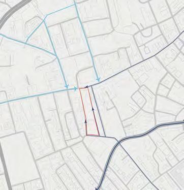
Pedestrian access occurs mostly at the north of the site, where the existing frontage remains and is well connected by the main High-street as well as other pedestrian streets leading south from the town square. Vehicular access occurs to the rear of the site, in the location of the former car park. Syke Street is linked via Avenham Lane to the Ring-road and out to the wider city area. The site is currently viewed to the north as a link within the chain of the high-street, however from the south it appears as a sloping eye-line towards the city skyline and key urban artefacts beyond. While the south may be regarded as an ancillary entrance it provides opportunity to see the site in a wider context.
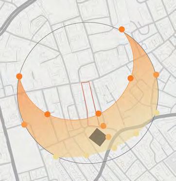
The site is well connected to public transport and cycle routes, with bus stops linking to the wider city and suburbs located directly to the north of the site and within a 5 min walking radius. Preston Bus station and Train Station a 5 and 10 min walk respectively. Recommended cycle routes run adjacent to the site to the east and west, and link to the neighbouring suburbs, university, schools and the riverside and local green-spaces. The accessibility of the site via these green infrastructural networks is key to defining the potential users and dwellers on the site, it is key to the buildings longevity that the homes locate in a positive way within their users daily lives.