15 minute read
Learning to Multiply Miriam García García (ES), PhD in Architecture, landscape architect & urban designer
Learning to Multiply
Analysis article by Miriam García García (ES) — PhD in Architecture, landscape architect & urban designer www.landlab.es/en/
Advertisement
The sites in this group are large in relation to their contexts, and include a wide variety of agents, human and non-human, with long and short-term cycles, as well as long-reaching ecological, economical and territorial implications. Multiplying agencies implies working with the relations, processes, flows and multiple forces related to the site. In this context, adopting a broader system perspective means that spatial limits must be extended and abstracted so that they reinforce an agreed division between what is human —the society and its culture— on the one hand, and what is nature —the ecosphere— on the other. The temporal limits must also be extended to match the spatial limits. This socioecological perspective applied to the productive city implies designing strategies that are able to catalyse new agencies around the site based on its synergies. This design-thinking approach leads to the integration of both social and ecological values into the design and into the management. In order to activate synergies and to change the sites metabolism into a more balanced and productive one the E15 winning projects deploy various fertile strategies.
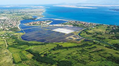
“SOFT BUFFERS” is not about introducing new uses but about catalysing new relationships between the existing ones, by turning the borders into intermediate landscapes for sharing. It is about permitting different flows to work together in a productive way while maintaining their differences. The city of Nin (HR) is located in a lagoon on the Eastern part of the Adriatic Sea, and is surrounded by natural sandy beaches (fig. 1). Four entities co-exist on the site, each with their own characteristics and without a productive relationship. There is the old town on Nin, the settlement of Ždrijac with coastal flooding effects due to climate change, and an old brickyard next to the saltworks.
3 — WEIZ (AT) > SEE MORE P.62
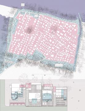
Winning project Soft buffers (fig. 2) shows the potential of the landscape as a mediator of fluxes and an activator of new uses that are visible from the scale of the architecture to the scale of the city. This way, the settlement of Ždrijac goes through a densification process while progressively being surrounded and protected by a forest park. The houses outdoor spaces serve both as public spaces and as cooling devices. The brickyard, surrounded by the landscape of constructed wetlands, gets a new chance to be productive. The wetland size is determined by the maximum number of inhabitants in Ždrijac at the peak of the Multiplying agencies tourist season, the wetimplies working with land becoming a device for waste managements the relations, processes, while simultaneously creating a new landscape flows and multiple that fits the existing ground. At the same time forces related to the site the constructed wetland sets up a new tradition of dealing with human waste, turning it into a catalyzer for the creation of a new biome. The wastewater treatment produces a by-product of sludge that becomes a fertilizer once processed.
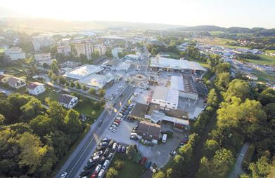
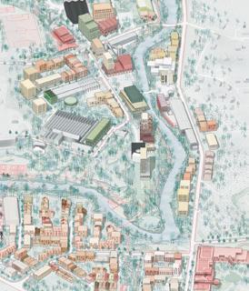
“PARALLEL AXIS” is about promoting the connections between the river and a human infrastructure —namely the currentlyunder-construction new mobility artery, which includes a rail track for commuter trains, a road, a bike path and several footbridges. The site of Weiz (AT) aspires to include new agencies, new layers of functions that may lead to a balanced growth (fig. 3). Winning project, Learning from the Future (fig. 4), proposes a sustainable, experimental, and active urban landscape to match and reflect the inhabitants’ creative and entrepreneurial energy. The masterplan designs both the physical spaces and their strategies from the perspective of a circular economy, intensifying the local strengths, namely the pioneering attitude towards energy and climate, which has yielded world-class industries and knowledge services. The project addresses several scales and
4 — WEIZ (AT), WINNER — LEARNING FROM THE FUTURE > SEE MORE P.63
ecologies along the mobility infrastructure and the river that feed one another. The potential of the idea lies in the detailed approach: the single public surface not only links the green space with the urban texture, but it also defines different scales and allocates traffic speeds. The project works with the site values and makes use of the existing relationship between the river and the street. It highlights the specificity of the place by connecting the single elements into one coherent tissue, thereby creating a strong identification of the street.
“ACTIVE MEGA-VOID” is about creating productive hybridities between existing resources and new inputs combining mobility and nature to organize a larger productive metabolism. Here, the larger scale and metropolitan dimension are particularly important.
5 — CHAMPIGNY-SUR-MARNE (FR) > SEE MORE P.38
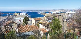
7 — MARSEILLE (FR) > SEE MORE P.46
6 — CHAMPIGNY (FR), WINNER — LOST HIGHWAY – (L)EARNING FROM A87 > SEE MORE P.39
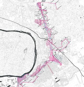
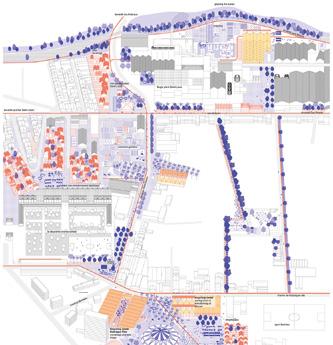
8 — MARSEILLE (FR), RUNNER-UP — LEARNING FROM MARSEILLE > SEE MORE P.48
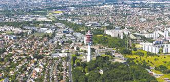
The site of Champigny-sur-Marne (FR) is part of the A87 project for a third motorway ring road planned in Paris in the 1960s (fig. 5). This global project was never implemented and was finally abandoned in the 1980s. A piece of territory on the East of Paris —namely the towns of Sucy, Ormesson, Chennevières, Champigny-sur-Marne and Villiers)— is crossed by a corridor of land that this unfinished project has literally frozen. These pending lands create a surprising and singular void in the dense Designing a grid of periphery. The result is an public spaces and local exceptional metropolitan garden phenomenon on actors that operates at this scale. Today, the various parcels that make up multiple scales, from the this lost highway are the support of isolated urban territory to the individual development projects. The urbanization process should develop around a bus line that crosses the axis along its length, connecting two future stations of the Greater Paris region. Winning project Lost Highway (fig. 6) intensifies the role of the void with a territorial strategy instead of filling it in. As a result, the emergent metropolitan garden becomes a backbone for the different municipalities, and relies on the system of Sensitive Natural Areas in force in the Val-de-Marne region. The project of public transport by would develop around this green lung, but this time in a transversal way to create a dialogue with the surrounding environment. The proposal foreshadows a succession of parks and project sites capable of forming a green belt in accordance with urban developments and improving their purposes. The project proposes to work on the edges of the corridor, examining built densities and possibilities to preserve the open space.
“MULTISCALAR NETWORK” is about designing a grid of public spaces and local actors that operates at multiple scales, from the territory to the individual. In the South of France, Marseille Rénovation Urbaine (MRU) has big expectations for the Cabucelle site, a popular district where business and residential uses and a myriad of other informal activities are expected to initiate a gradual re-appropriation (fig. 7). Runner-up team Learning from Marseille (fig. 8) envisions La Cabucelle as an exhibition space for experimentations on techniques of building and managing public spaces towards a zero-waste district that would stand as an example for the Mediterranean region. The whole project relies on the learning process as an “initiatory journey” developed by the Tour de France companions —a training companionship for professional craftsmen. In this way, it is a vision of a
productive city as a cultural change that reverses the consumption trends, involving an educational project. The project contributes to connecting people and activities through apprenticeships; it is, in real terms, an unequivocal call to connect urban renewal to job creation, training programs and the development of micro-economies for a population far from formal employment. It also associates public spaces to a progressive and participatory renovation process, establishing new relationships between indoor and outdoor public or private spaces and creating the conditions for the emergence of semi-public or semi-private public spaces. The plan includes a comprehensive green proposal, drawing a difference between slow (cycle paths and pedestrian access) and fast (cycle paths, road for vans and cars) networks. This network connects the district to the new green infrastructure that will connect it to the city centre. On a metropolitan scale, the companions’ initiatory journey follows the rivers and contributes at extending the soft mobility network. The visual opening on the maritime and mountain landscape as well as the reinforced accessibility by public transport (with the creation of the new TER Litorral-Cabu stop-over) establish the district as a new centre connected to the metropolitan area.
“MULTI-LAYERED ISLAND” is not a collection of diverse buildings, but one big interconnected ecosystem where energy, water, working spaces and waste solutions are shared. The site of Vierhavensblok has a rich history as a
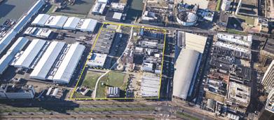
9 — ROTTERDAM VIERHAVENSBLOK (NL) > SEE MORE P.54 productive district of Rotterdam (NL). The challenge is to transform an industrial port area into a Circular Urban Makers District around the notion of a circular city where working and living meet (fig. 9). In Makers’ Maze (fig. 10), the winning project, architecture is reconnected with the economic, social and political realities of the city by offering a flexible method rather than a rigid design. The requested programmatic mix of 30-40% businesses, 10-20% offices, 30-50% housing, and 10% services is easy to achieve and adjust, because the clusters are developed not in tandem, but one by one, allowing small adjustments based on market pressures. The charm of Vierhavensblok lies in its informal character, where one can find the unexpected around every corner and where chance encounters and meetings breed new collaborations. Inspired by these qualities, Makers’ Maze proposes a series of building clusters interlocking around a network of passages, streets and squares, creating a unified, resilient and unexpected urban scheme. The streets and squares of the masterplan are defined by the surrounding architectural volumes, both new and existing. The clusters work as showcases of materials and provide a way to organize, categorize and label them. Existing workshops are no longer temporary, but rather become an integral part of the foundation of the plan. New volumes are attached to them or cantilevered above them. These new structures, besides adding floor space, provide access to rooftops and are also used as communal gardens with shared functions: laundry rooms, storage, flex offices, game rooms, labs etc. Layers of shared spaces work as buffers between the living and working zones and create a diverse, mixed urban fabric: not only horizontally, but also vertically.

“ARCHIPELAGO OF CLUSTERS” is characterized by a form of free-flowing occupation, where smooth multifunctional spaces sometimes overlap and blend into smooth experiences. In this socio-ecological system, polarities of clusters intuitively define an in-between multifunctional space. The site of Guovdageaidnu (NO) is a culturally conditioned landscape-urbanity based on continuous territorial mobility (fig. 11). The place holds the history of a nature-based household and practices connected to a larger territory; at the same time, it is in transition towards a more ambiguous relation between landscape and settlement, nomadic livelihood and a more sedentary lifestyle. Guovdageaidnu is visually and physically defined in a clear topography and by clusters of public buildings and services surrounded by sprawling housing areas. The building pattern and the interconnecting landscape allow a large degree of free movement between buildings and functions, settlements and landscape. Here, the two awarded projects show the complexity of this socio-ecological system where the Sámi identity is closely linked to the relationship between human activities and the landscape through soft layers of mobility and connectivity.
Co-winning project Catalogue of ideas (fig. 12) interestingly frames the site as having developed or unfolded between the “smooth” space of the tundra and the “striated” space of the modern welfare state. It further elaborates this framing by proposing a set of five strategies to strengthen and articulate a specific “Sámi urbanism”, in which the multifunctionality of the public space, informal pathways connecting urban and natural points of interest, as well as a functional acupuncture enhance the existing forms of production and expression. A major strength of the project lies in the recognition of territorial and ownership challenges and in the suggestion of a Land Trust in order to meet the intensified need to coordinate land use development and management. This way, Guovdageaidnu’s islands of urbanity in the tundra can reflect its past and present; it is a hybrid manifestation of ancient nomadism and the introduction of modernity with five densified central clusters. Radical Reimagining, the other winning project (fig. 13), presents a solid analysis of the site and the region as depending on larger fields of relations and patterns
11 — GUOVDAGEAIDNU (NO) > SEE MORE P.42

How smooth became striated
Sámi strategies
Smooth Tundra Push multifunctionality of domination and subordination. It also takes into consideration daily uses and interactions. Based on an understanding of the landscape as the main element to consider, the proposal acknowledges the limits of conventional planning and architecture. It aims to identify new approaches to knowledge and experience that would enhance existing practices and support the development of new ones. Emphasizing on the importance to listen to and to connect stories, memories and livelihoods, it gently presents a series of ‘productive’ strategies and places: oral mapping and knowledge sharing, embodied encounters and symbolic ‘wrapping’ which, instead of providing fixed solutions, offers departure points to reimagine productivity as well as urbanity. In this project, everyone can become an actor to establish and maintain the links between nature and culture in the vast productive archipelago of Guovdageaidnu.
“GREEN AND BLUE CORRIDOR” uses natural systems to manage water in wide neutral grounds that should also serve as support systems for a productive regulation, habitat for wildlife, and community liveability along the designed landscape. In the site of Borås (SE) the connection of the Gässlösa district to the city centre and the relation to the existing buildings, to the water and to green structures are key elements for the landscape and the economy (fig. 14). Winning project Made in Borås (fig. 15) proposes to consider the city’s riverscape as a strong tool to renew Gässlösa’s, providing high quality living and climate adaptability. This approach led to the conceptualisation of a metropolitan river park at the core of Borås and its future developments, introducing the necessary spatial qualities for denser urban living. The river park provides Borås with a strong vision, easy to comprehend by all and in direct interaction with the daily life of the inhabitants. It offers Borås a valuable
Connectivity Improve the path network
Introduction of functions
Polarity of clusters Functional acupuncture
Urbanize clusters
Striated Guovdageaidnu Densify Guovdageaidnu
FURTHER FIXED 00 - Point 01 - Point
FURTHER FLEXIBLE 02 - Mormorcafe
THE FIXED 03 - Airport 04 - The Bridge 05 - Sirkustomten 06 - Sirkustomten Storage 07 - Bird Watching Tower 08 - Sauna 09 - Fishing Platform 10 - Slip 11 - Slip Storage
12 - Markanden Storage THE FLEXIBLE 13 - Mormor Cafe 14 - The Spoken Land 15 - Wrapping Guovdageaidnu
14 — BORÅS (SE) > SEE MORE P.34


16 — TÄBY (SE) > SEE MORE P.58
15 — BORÅS (SE), WINNER — MADE IN BORÅS > SEE MORE P.35
blue-green heart while providing new connections and greatly improving access throughout the city and Gässlösa, currently characterised by a fragmented tissue. In order to sustainably (re-)create nature, the Multiplying agencies project uses for example phytoremediation for a more balanced through composting and crop rotation to metabolism that reduces clean and restore life back to the soil. These the environmental impact productive landscapes will be established early enough to immediately bring a new meaning and coherence to Gässlösa and involve communities into shaping the city of tomorrow.
“MIX-MATRIX GROUND” encourages the ground level through a pedestrian neighbourhood with an urban mixed-use between living and public amenities in order to catalyse social and economic interactions. Arninge-Ullna, in Täby (SE) is a rapidly changing district along the highway artery North of Stockholm. The area was established in the 1970’s as an island of car-based production and shopping inserted between beautiful landscapes, yet poorly connected (fig. 16). Winning project The Generous City (fig.17) offers a positive vision for the productive city of the future. Based on the topics of resources, mobility and equity the proposal suggests three strategies to develop productive cities: ‘Mix More’, ‘Move More’ and ‘Meet More’. Within
17 — TÄBY (SE), WINNER — THE GENEROUS CITY > SEE MORE P.59

the strategies, new and traditional urban planning tools are used to transform the existing large-scale and carbound monoculture into a mixed, dense and rich matrix where everyone is welcome and able to contribute. The ‘Mix More’ strategy enables city and nature to mix in order to strengthen natural cycles of air, soil and water. Streets, squares and courtyards are designed to absorb water and snow, reduce heat, clean air and help birds and other species to find their place in the city. The Generous Park also plays an active part in maintaining the ecological balance and creating an inclusive and democratic space. The ‘Move More’ strategy is designed to encourage the use of bikes, electric scooters and other light electric vehicles. This soft mobility with pocket parks and places for spontaneous sports and recreation creates a type of urbanity where people are invited and encouraged to spend time in public spaces (‘Meet More’).
CONCLUSION The comprehension of cities and regions as Complex Adaptive Systems (CAS) claims for responses for the combination of planning and design that catalyse cultural and physical processes aimed at improving their metabolism. The E15 winning projects responses are based on more dynamic models to analyse and design ecosystem structures and behaviours. That implies creativity based on ecology and embodied in strategic scenarios and tactical designs. Because by tracing the flows of resources or information into and out of the “built environment”, and incorporating changes accordingly to close the loops through the re-use, readaptation and regeneration of materials and spaces, it is possible to multiply agencies for a more balanced metabolism that reduces the environmental impact.


