HELLO
I have recently graduated from the Master of Urban Design program at UBC and have three years of experience in architecture and urban design. My proficiency in technical design, problem-solving, community engagement, and sustainable urban design makes me a valuable addition to any team.
As a team player with exceptional leadership and communication skills, I consistently deliver high-quality work and thrive in collaborative environments. I am dedicated to producing outstanding outputs and committed to incorporating sustainable urban design principles in all my projects. I am confident that my expertise will help elevate your projects to new heights.

PROJECTS
2022 -2023
01 03 04 05 06 07
Revitalizing the Central Water Front & DownTown East Side
Downtown Vancouver - Academic work - Master of Urban Design
02
Land back and saving first nations lands
Pitt Meadows- Vancouver - Academic work - Master of Urban Design
Sociability In North Vancouver Neighborhoods
North Vancouver- Vancouver - Academic work - Master Of Urban Design
2019-2022
Reconnection Urban Strip
Sadra City , Shiraz- Iran - Professional
Developed Mixed Used - K5
Kish Islan , Iran - Professional
2014-2018
Brownfields and puclic health
Shiraz , Iran - Academic work - Bachelore of Urban Planning
Regeneration and rihabilitation of ‘Ghalat village’
Ghalat , Shiraz , Iran - Academic work - Bachelore
Revitalizing the Central Water Front & DownTown East Side
Downtown Vancouver - Academic work - Master of Urban Design

Introducing our urban design project focused on revitalizing the Central Waterfront and East Side neighborhoods of Vancouver, with a specific emphasis on addressing the needs of youth. Our project aims to reconnect disparate nodes of the area and alleviate deficiencies, such as housing crises, loss of history, climate change, and pollution.
Our project is signifcant within the broader context of urban design as it offers a new approach to addressing the complex challenges facing cities today. By carefully analyzing the site, we have developed a design concept that prioritizes sustainability, affordability, and accessibility. By creating a more livable and resilient urban fabric in Downtown East Side and Central Waterfront Vancouver, we hope to inspire other cities to follow suit and create a more equitable and sustainable future for all.”
Even though the Central Waterfront in Vancouver is a place that many people pass through on a daily basis, it does not have any particular features that would encourage people to stay or spend an extended amount of time there.
In order to achieve our final design, we focused on connecting the three distinct areas of Vancouver - China Town, Gas Town, and Waterfront - through an activated route that begins at the Waterfront station and moves through Cambie, Pender, and a hidden street nestled among buildings before reaching the central waterfront. Each of these cultural and historical streets has its own unique theme, including a 24-hour food street, a traditional and cultural fashion street, a food street, and an art street. The end goal is a vibrant and bustling community center, which serves as an architectural landmark, alongside floating dorms constructed with recycled materials.
Urban Design Stuidio III I University of British Columbia

Supervisor : Derek Lee
Site Location: Central Water Front , Downtown East Side - Canada , Vancouver
Completed : Dec 2023- May 2023
Applications : Sketchup , Rhino , Illustartor , Photoshop , In Design
CONNECTED vs DISCONNECTED
Challenge 1: Losing the historical and cultural character Opportunities 1: Strong historical background that can be revitalized


Challenge 2: Urban Heat Island/ Sea Level Rising Opportunities 2: Implement adaptable spaces and buildings – forces necessarily sustainable thinking
Challenge 3: housing crises and inequity Opportunities 3: The space to utilize neglected brownfields to provide housing for those within the crisis


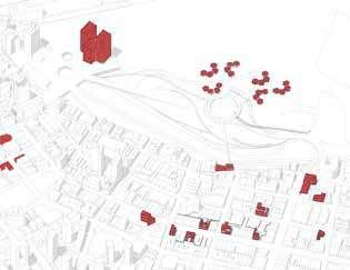


Empowering Youth to Connect Communities
New
Type of Houses And Neighborhood
Set Back = Community Garden + Sustainable Building Set Back + Semi Private Ground floor = Invite people from outside to inside


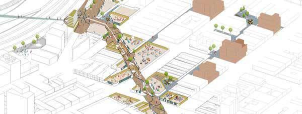

Traditional Fashion Street ( Cambie St )
Traditional Art Street ( That Hidden Street )
Set Back = New Gathering Space
Owners will Give bones to add more density if use the recommended Building Occupancy

Rose: Hey, that sounds like a great idea, I would love to come!
Rose: Yeah, it’s unbelievable how fast it went by. I’ve grown so attached to this place, I can’t imagine leaving anytime soon.
Rose: Wow, congrats on getting into SFU! Those dorms sound amazing, I’m sure you’ll love living there.
Hey there Rose, how’s it going? Have you heard about the Piano Festival today? I was wondering if you’d like to join us?
Oh wow, it’s crazy to think that we met way back in our painting class in block 3 when we were just 10 and 12 years old. Now we’re almost 20, time really flies, doesn’t it?
I totally get that, I feel the same way. But I actually just got admission to SFU and I’ve been thinking about moving out of my parents’ place. I found these really cute dorms on the water that are surprisingly affordable for me, what do you think?
Protecting Historcal Fabric Step back in time and immerse yourself in history by visiting our heritage buildings
Developing a Sense of Collaboration for Environmental Preservation
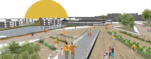


A perfect place, where life, work, and communication blend seamlessly. A place that evokes a sense of nostalgia, and offers everything within reach. A place where dreams come true, and where one can truly belong.

Land back and saving first nations lands
Costal Urbanism - Living with Water / Land Use strategies and Landscape Design
The Urban Design project focuses on improving flood management and coastal livelihoods in Pit Meadows, a city located at the edge of the Fraser River Delta. The project aims to save the Katzie Lands from flooding by utilizing strategies that enhance habitat, food and energy production, and recreational areas. The focus of the project is on the water and the rising sea level, which is analyzed in 4 time frames (2022, 2032, 2052, 2097). The project aims to create a connection between people and water, inviting more visitors to the First Nations lands.
Urban Design Stuidio II I University of British Columbia

Supervisor : Kees Lokman
Site Location: Pitt Meadows - Canada , Vancouver
Completed : SEP 2022- DEC 2022
Applications : Sketchup , Rhino , Illustartor , Photoshop


Strategies for Site B - Saving Katzie Land

 Flooded Houses
Katzi Houses on High Land
Food Forest
Food Forest
Katzie ‘s farm land
Design from Resident and User Group Perspectives

I’ve been here for a long time. After designers offer us newly constructed flooding houses, our children will be able to live here as well. In addition, we have made significant financial progress by selling fish and agricultural products through both water transportation and highways.

It is wonderful for us to visit Katzie Land and purchase locally grown and fresh vegetables and fruits.
Hello,
I’m an Indigenous person who has been here for about 50 years, and my parents came here before me. We also experienced a lot of water issues due to an ineffective dike, but we want to live here because this land is ours.
I’m glad that after years of building highlands for us, we can now live here, produce items on our land, and sell them easily when people come to visit.
Strategies for Site A - Connect people to Water


Light Water stream
HI.My name is Lora I’m 10 yeras . . My family and I occasionally go to the food forest which is close to our home to select our own fruits; it’s a fantastic hobby for me to do it after my homework.
We close to the commercial do our that
Hey, I’m Jack, and I adore fishing. Unfortunately, there aren’t many options in the area. I’ve spent most of my leisure time here, especially when the water level is low.
are really glad to live in these multi-family houses close to the Farm and Food Forest. There are close the Farm and Food Forest, Also there are various commercial portions on our first floor where we can our daily shopping and only eat local fresh things are beneficial to our bodies because of our age.


I’m a cyclist. Cycling here is a beautiful experience, especially when the sea level is high and I appear to be on the water.
We come here on weekends and holidays to stay at these rebuilt resorts, and there is too much training for walking near this region with a fresh atmosphere.
My grandson and I visit the Aqua farm occasionally to grow berries and strawberries by ourselvesWhat Was we had , what can will have


Residential Highland
Afer 75 Years
lands back to Katzie people
Give more roome to river
Afer 75 Years
Flooding Control save ecosystem Reduce distance


Invitepeople to Katzie Lands
Afer 75 Years
Save Katzie Land Katzie Land03
Sociability In North Vancouver Neighborhoods

Design Neighborhood Typology / design strategies for creating livable, affordable, sustainable, sociable, and walkable neighbourhoods.


The neighborhood designated for this project is situated in North Vancouver, specifically located between E11th and E12th streets. It boasts an ideal location in close proximity to parks and open spaces, which can be conveniently accessed within a five-minute walk or less. However, there are some challenges that need to be addressed, such as the fact that public restrooms and supermarkets are situated more than eight minutes away. Additionally, there are currently no public gathering spaces in the vicinity, and the area is predominantly residential.
The primary objective of this development is to promote sociability and facilitate an optimal environment for intergenerational living and aging in place. To achieve this goal, we have carefully designed the dwellings to feature large balconies, courtyards, laneways, and apartments, which serve as regular points of connection for individuals of all ages. We have also incorporated various features and amenities that cater to the needs of diverse age groups.
-Using different types of houses which are suitable and affordable for all ages


-Using a variety of amenities with less than-five minutes’ walks from the residence.
Urban Design Stuidio I I University of British Columbia
Supervisor : Yuichi Watanabe
Site Location: Nort Vancouver - Canada , Vancouver
Completed : JUN 2022- SEP 2022
Applications : Sketchup , Rhino , Illustartor , Photoshop / In Design

Problem Statement




Hello, my name is David, and I’ve been residing in this area for the past 40 years with my wife. Since our children have moved to the United States, we must rent out the second floor of our two-story house, which we own. We merely require a young pair to help us and occasionally engage in conversation (60- 70)
Hello, my name is Sara, and my husband and I just moved here for work. We rent the top floor of an apartment owned by an elderly couple since we cannot locate an affordable place to live (20-30)


Hey, we’ve been here for over 50 years, and as we get older, we need to be able to live independently with better safety and appropriate services in our home and neighbourhood. (80-90)


Hello, we are a 40-year-old couple with two kids who rent this house, but we have a number of access and distance issues.(3-40)


Implementing Design on the neighborhood
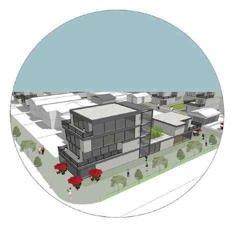
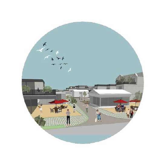

Patio in pedestrain
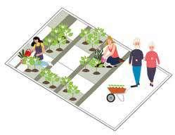
Neighborhood Farming
Affordable House for aging with lock-off suits
converting garage and parking to amenities
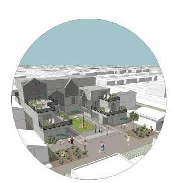
Activate Laneway connection between street by appropriate uses
Housing with commercial part in first floor
Court Yard
Removing garage and parking
Gathering Area
Adding more density to these types which have less lots size
Implementing Design on the neighborhood


Where are the public social spaces?




Where Is the best place for aging and living in the neighborhood?


Reconnection Urban Strip
Land use Planning , Urban design , Land Division ,Design Building Typology
This Project Is located in Sadra small city, which is in Shiraz – Iran. This Project is part of a large master plan for 86 Hectares of land in Sadra. The way that we designed this area is based on the topography of the land. After that, the second idea is to have more affordable houses which have the most livable atmosphere.

Reconnection urban strip” can be introduced as the backbone and one of the most important and main east-west streets of the new city of Sadra. In the western part of this axis, in an area with an approximate length of 420 meters, it is planned to design a mixed-use strip. By creating a development stimulus hub at this point, a balance can be struck between the three points east, center, and west of the new city of Sadra, with the difference that other hubs of the city are uncoordinated.
*Note : Most Relevant Pages from the original document have been Extracted
Work Experiance I Iran, Shiraz / Khat & Safhe Consulting Architecture and urban design http://khatosafhe.com/en/project/C/-Urban-Design
Supervisor : Aslan Jonoubi
Site Location: Iran, Shiraz , New Sadra City
Completed : 2020
Applications : Sketchup , Auto Cad , Illustartor , Photoshop
My Contributions : Prepare 3D model by Sketchup, Assistant in the design of the building codes and types, Report Design Layout

Site Analysis Strategies






The project is situated on the former Shiraz-Isfahan route, which runs between Sadra Shiraz’s districts 1 and 3. The idea behind this project is eco urbanism, a subcategory of sustainable design because of the site’s natural topography slopes. This street will be used as a connecting street. As a result, there are numerous chances for welcoming people to the area.
The project is situated on the former Shiraz-Isfahan route, which runs between Sadra Shiraz’s districts 1 and 3. The idea behind this project is eco urbanism, a subcategory of sustainable design because of the site’s natural topography slopes. This street will be used as a connecting street. As a result, there are numerous chances for welcoming people to the area. In this project, we recommended types of housing and divided the land by topography that we have


Strategies
The façade was created in a vibrant and lively manner by returning to the past and employing Iranian architectural principles. The porch’s employment as the primary feature in the development of this strip creates uniformity and integration in the urban landscape, as well as spatial determination. Furthermore, the shadow and light cast by these porches shield the audience from direct sunshine and rain. The green space design in this strip, by creating a connection and crossings for pedestrians and bicycles, allows them to feel the presence of high-quality urban space in a safe and climate-comfortable atmosphere.
recommended mass form and facade


Developed Mixed Used - K5
Conceptual Architecture , Developed Project , Urban Design
K5 Mixed used architectural and urban design project is located at Kish Island Iran, in the south of Iran. At the edge of the Persian Golf. This project is a mix of Urban design and architecture since between the building we design open space and pedestrian paths with different amenities and facilities.

The soft, organic, and green project, both in plan and in cross-section, is composed of a sequence of soft motions and curved lines that evoke a sense of continuing sea waves on an artificial landscape as if the waves were enveloping the site. In order to pass the sea breeze and create various views, spaces have been emptied among the volumes that have made social interactions possible in this place. Also, on the roof of the project, which connects the volumes, water facilities overlooking the Persian Gulf, make it possible for residents to use water recreation in different seasons.
*Note : Most Relevant Pages from the original document have been Extracted
Work Experiance I Iran, Shiraz / Khat & Safhe Consulting Architecture and urban design http://khatosafhe.com/en/project/C/-Urban-Design
Supervisor : Aslan Jonoubi
Site Location: Iran, Kish Islan
Completed : 2021
Applications : Sketchup , Auto Cad , Revit, Illustartor , Photoshop
My Contributions : Prepare 3D model by Sketchup, Assistance in design concept, Assistance for presentation graphics

Location of residential, hotel and commercial blocks in the plan
The most important feature in the design of the K5 multifunctional project is the presence of an open corridor in the center of a series of volumes, which extends as an interconnected chain throughout the volume. This corridor, as the central lobby, provides lighting for the spaces and rooms of the residential units. This path is like an urban space, it has been created so exploratory and diverse that it is like passing on an urban street with very different perspectives.
Parking location of each uses in the plan
Radial arrangement of commercial units taking into account the geometric form of the plan


Form of project consists of cubes that have slipped on top of each other and each one goes back a little, making it possible to watch the sky from each of these terraces. Terraces that are considered a yard with sufficient dimensions for the units provide a special view for the residents.


Brownfields and puclic health
Land use plnnig & Urban Design
Brownfields can have an indirect impact on public health in a variety of ways due to contamination that can affect on- and off-site soil, air, and water resources. Walking on the site, wind moving contamination off the site, or drinking groundwater contaminated by the site could expose people to these hazards. This might happen prior to, during, or after renovation. Brownfield redevelopment, as done in this project, is good public health practise. It can promote public health by limiting exposure to dangerous pollutants, restoring ecological balance, lowering the effects of urban heat islands, and encouraging physical exercise and recreation.
Bachelore of Urban Design and Planning Stuidio I Shiraz University

Site Location: Iran, Shiraz
Completed : SEP 2017- Nov 2017
Applications : Sketchup , Auto Cad , GIS ,Photoshop

Site Analysis
This project is located in Shiraz’s greatest southern regions, close to the city’s southern gate, and is surrounded by pine trees and the Shiraz Drak Mountain range. A business center for repair activities is located to the site’s south, while a residential area is located behind it. Due to the location of the property in a residential and industrial region, one of the challenges with this area is the absence of a clear identity. The property is in the best position to merit having a residential area in line with the regulations and objectives of public health urban planning because of its geographic location and the presence of the necessary natural elements.

Design process diagram
Strategy:
-’30 speed’ rules for local roads
-Using land topography to optimize surface water disposal
-Courtyard building blocks and typology
-Establishing user facilities by considering the optimal access radius according to the site area


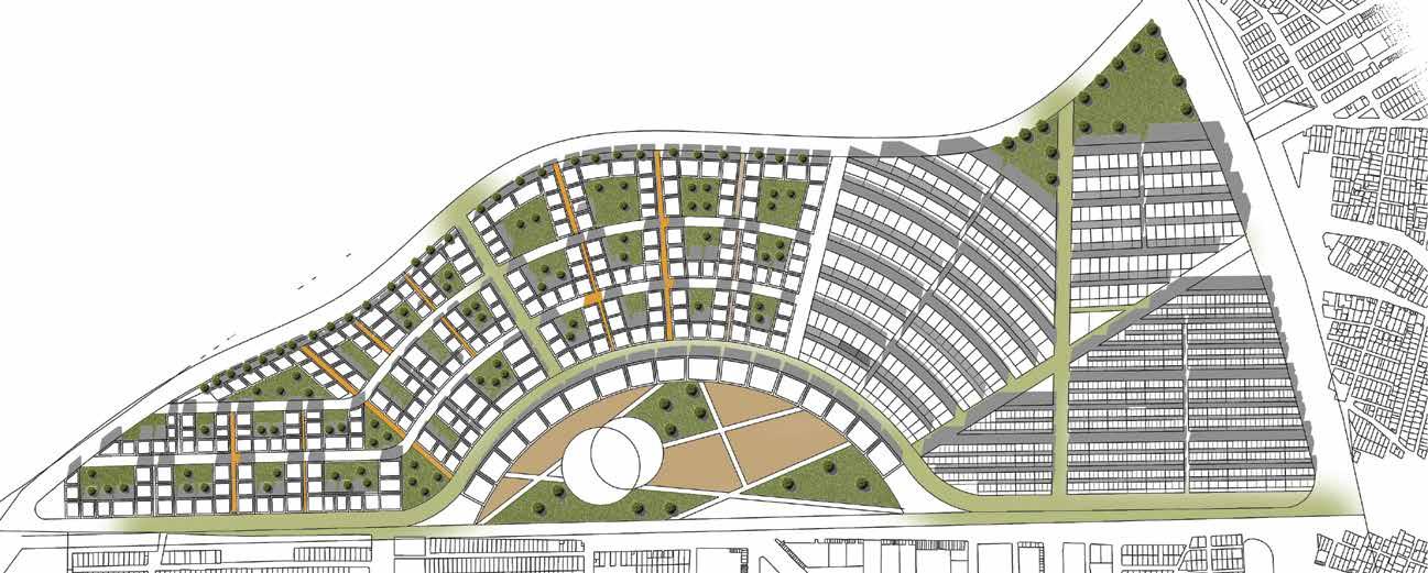
-Structuring and dividing the site according to the grading of the passage paths and the width of the street’s goals:


-Balanced distribution of private and public spaces
-Increasing the security and sense of belonging of the residents in their neighborhoods
-Using old factory buildings and turning them into a recreational and tourism environment on a regional scale
-Reducing noise pollution and environmental pollution
-Demolished brownfields
Main roads street network Green public space semi private green space Figure plan Subdivision plan public space curt yard apartments ,4-5 floors bicycle and emergency path 5-6 floors apartments retail shops 6 -7 floors apartments preserving Cement factory Master planRegeneration and rihabilitation of ‘Ghalat village’
Sustainable Urban Design , Master Planning
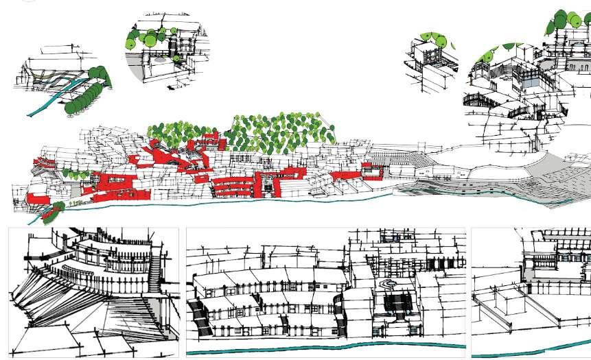
In recent years, considering rapid scientific and technical developments, followed by changes in the social, economic, and physical structure of cities and the theory of sustainable urban development, the significance of improving and reviving cities and villages has increased. urban and rural areas are vulnerable because of physical issues as they lack proper access to transportation, facilities, services, and urban infrastructure that they have low spatial, environmental, and economic values. The structure has failed to meet the needs of the community because of age and physical problems. Therefore, in this project, due to the great potential in increasing the intensity of land productivity, attempts were made to improve the physical and functional aspects. Moreover, the intent of the project is to not just restore the ecosystem, but also to regenerate the degraded natural ecosystem.
Bachelore of Urban Design and Planning Stuidio I Shiraz University
Site Location: Iran, Shiraz , Ghalat
Completed : AUG 2018- Nov 2018
Applications : Sketchup , Auto Cad , GIS ,Photoshop , Hand sketch

Site Analysis Concept
“Ghalat “is a very beautiful village which is situated 36 km northwest of Shiraz in mountainous areas with a multitude of trees and lush gardens. The local people of this village live a semi-traditional life, working in agriculture, animal husbandry, and horticulture businesses and some are busy engaging in weaving. In this village, there are buildings that can be preserved, including the village church. In recent years, this village has become a place of tourist attraction and recreation, but unfortunately, it has lost its identity and the villagers of that area do not benefit from proper urban infrastructure.
Strategies:
-Providing walkable, mixed-use neighborhoods People can provide their own products without commuting to town


-The residential can sustain a range of key services
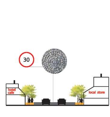

-Providing an area with its own atmosphere and sense of place
-Each traditional house has its own business such as a hotel, or cafe. Restaurants and farmland how to make trust among residents.
road networks essential nodes figure plan Building forms floor plan land use planfacing materials
Houses have to use the same materils which are similar with landscape of Ghalat village

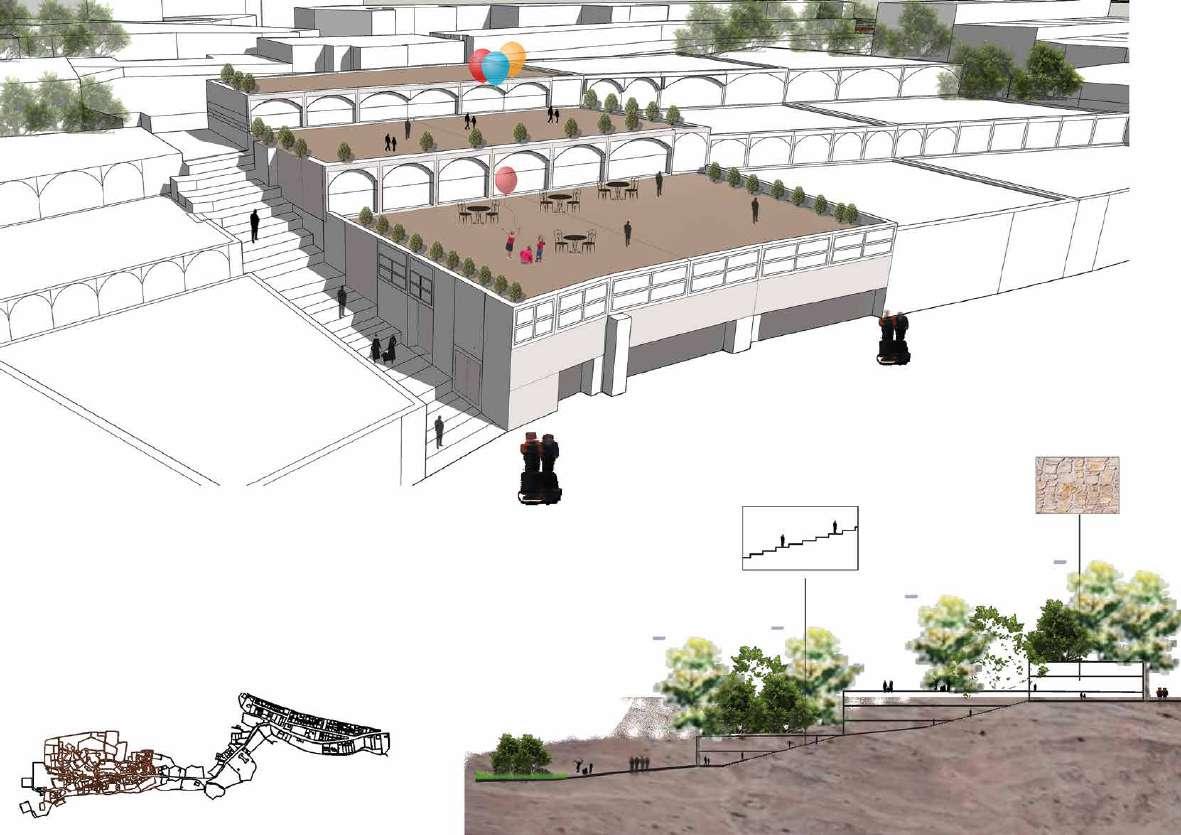 stairs section
cafe and resturant

