
9 minute read
4.5 LANDSCAPE & VISUAL IMPACT ASSESSMENT - VISUAL


The Landscape and Visual Impact Assessment (LVIA) considers visual aspects of the proposal including how existing views of the site may change, the scale of any change (a large or small impact) and the severity of the change (is it a positive or negative). LVIA also considers the impact of the change over time, in this case after fifteen years - in the intervening period any proposed landscape is considered to have matured and therefore the impacts of the proposals may change.
With comprehensive redevelopment of the Phoenix site there are inevitably impacts to views. It is still the case that the existing site provides a visually poor baseline and new development provides an opportunity for a bold intervention for the betterment of Lewes and the National Park.
Advertisement
Long views are available to the site from the top of the town at the Castle and Brackmount and also looking down from the east at Malling Down. These have been tested with visualisations in order to form height parameters and dialogue on roofscape.
In closer views much is likely to be seen as visual improvement; the introduction of a high quality development, the replacement of poor quality buildings, the improvements to the riverside, including access.
The the task of the LVIA includes the objective assessment of the proposals on the current views baseline and this has a duty to call out where the new built form might say, interrupt the long view or occupy an extent of view to the detriment of the receptors experience of the place.
Some six of the verified views have been appraised as having the potential for significant adverse visual effects. These highlight sensitivities to be born in mind when detailed proposals come forward. In some cases, the assessment suggests the right proposal might not only lessen a negative impact but provide a beneficial one.
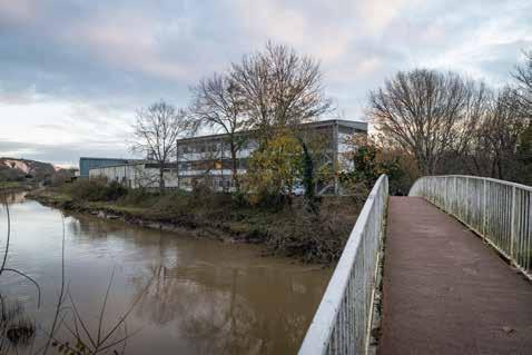
The six can be grouped as the view from Willey’s Bridge (VP 27), along the river from Malling Park (VP64 and 65), the Pells (VP F), adjacent town Conservation Area to the southwest (VP N & Q). The visual appraisal has assisted in the formulaton of the scheme, opening some gaps in the built form, lowering some heights and suggesting where better articulation is likely to be required.
Viewpoint (24mm) Panoramic (90-degrees)
Verified LVIA Viewpoints: Long views to the Phoenix
Verified LVIA views which will be preserved and/or changed:
7: LVIA verified view 7 Malling Hill, Malling Down (The Coombe)
14: LVIA verified view 14 Chapel Hill/Footpath (Public Right of Way)
32: LVIA verified view 32 South Tower (roof viewing platform), Lewes Castle
Z: Townscape View Z Brackmount
Verified LVIA Viewpoints: Across and beyond the Phoenix
Verified LVIA views which will be preserved and/or changed.
27: LVIA verified view 27 Willey’s Footbridge looking Downstream
63: LVIA verified view 63 Jenner’s Way meets Malling Recreation Ground (Right and Left)
64: LVIA verified view 64 Jenner’s Way and SOVW (Left, Centre and Right)
65: LVIA verified view 65 Jenner’s Way and SOVW (Left and Right)
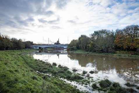
66: LVIA verified view 66 Phoenix Bridge and Causeway (A2029)
67: LVIA verified view 67 Phoenix Causeway (A2029) (Left and Right)
85: LVIA verified view 85 Skate Park, Malling Recreation ground, Footpath off Brooks Close
88: LVIA verified view 88
97: LVIA verified view 97 Pelham Terrace/Talbot Street facing Pells Pond next to Listed School House
99: LVIA verified view 99 Bankside path, mid-point along Malling Recreation Ground (Left, Centre and Right)
LVIA Townscape Viewpoints: Into the Phoenix

Verified LVIA views which will be preserved and/or changed.
F: Townscape View F Pells Pond from Pelham Terrace
N: Townscape View N Junction of Wellington Street (Car Park), North Street and Lancaster Street
P: Townscape View P Path (PRoW) adjacent to Green Wall adjacent to Residential properties no. 1 to 4
Q: Townscape View Q Green Wall SM/Wellington Street
R: Townscape View R Waterloo Place/Little East Street
S: Townscape View S Eastgate Baptist Church/A2029 Phoenix Causeway


4.6 DERELICTION & THE SITE TODAY

Physical decay
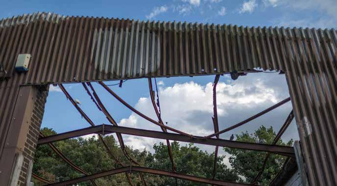
The physical condition of the site is increasingly poor, heritage assets, although unlisted are degrading; the existing principal foundry building (with the 1911 motif on its elevation) is structurally unsound and has been propped using a steel frame, it cannot be entered safely. The three other principal heritage buildings are in reality heritage structural frames with very poor-quality overcladding which has been allowed to degrade allowing vermin into the buildings.
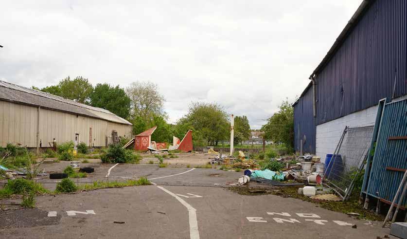
Demolition of parts of the unlisted older buildings in 2019 have revealed large areas of hard-standing which have accumulated waste and are surrounded by increasingly tired hoardings. Beyond this the 20th century buildings on site are reaching the end of their life, have poor environmental performance and are increasingly unused.
The remaining physical infrastructure on the site could most charitably be described has having been in ‘managed decline’ since the turn of the century. Highways infrastructure is an increasingly incoherent mix of dated arrangement, no longer fit for purpose and the flood wall is becoming increasingly unstable and lacking in resilience – so much so that the Environment Agency have in 2022 reinforced it. Informally arranged and poorly maintained surface car parks welcome visitors to the site and do nothing to improve first impressions. This level of physical decay is the primary image of the site in held in the minds of the communities of Lewes.
Cultural heritage decay
At least as concerning as the physical dereliction of the site is the erosion and decay of the site’s cultural heritage. As physical decay of the Phoenix site increased, so too did the size of the art and making community. Spaces that are of low commercial value are often attractive to artists and creatives who require spaces large and small but who often cannot afford commercial market rents; The Phoenix site, in the late 20th century and early 21st century, became a haven for artists, particularly in the Foundry Workshop and Gallery.
Many of these individuals and organisations operated from the site for decades before the previous owners of the site began to move them out. This wanton vandalism of living cultural heritage partly led to the formation of Lewes Phoenix Rising and the beginning of the road to Human Nature’s involvement in the site.
Some organisations such as Starfish studios, Studio Hardie remain but in buildings which are reaching the end of their life; major questions hang over their long-term viability.

4.7 CONSERVATION AREA
The Lewes Conservation Area
The Lewes Conservation Area was designated in 1970 and extended in 2012. A Conservation Area Appraisal was produced in April 2007 by the Conservation Studio (Lewes District Council, 2007). Primarily the Conservation Area encompasses the historic core of Lewes situated immediately south of the site. A small portion of the Conservation Area is situated within the Site, comprising land occupied by Springman House, alongside land situated to the south of Back to Grain and west of Phoenix House. The remainder of the site is situated beyond the Conservation Area boundary. Refer to the Heritage Statement appended to this application for a comprehensive description of the important aspects that together contribute to the overall character of the Lewes Conservation Area.
The buildings and public realm comprising the proposed development should be designed in such a way that limits its impact on (or enhances) the Conservation Area. Design aspects potentially impacting the Lewes Conservation Area (particularly material palette, form and urban grain) should be carefully controlled in future Reserved Matters Applications via the Design Code and Parameter Plans.
The Malling Deanery Conservation Area
The Malling Deanery Conservation Area is located north of the site to the north east side of the River Ouse and was designated in 1974. This Conservation Area covers the area surrounding South Malling Church and Malling Deanery. A Conservation Area Appraisal and Management Plan was adopted by the South Downs National Park Authority in 2015 (SDNPA, 2015).
The Heritage and LVIA Assessments indicate that there will be little or no impact to this Conservation Area due to vegetation buffers.
Key Grade I Grade II Grade II*
Scheduled Monument
Lewes Conservation Area
Malling Deanery Conservation Area
4.8 HERITAGE
Retained Buildings
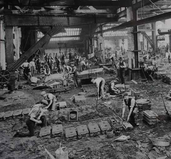
The Phoenix Iron Works is a non-designated heritage asset located within the site. The Iron Works and its successors played an important role during the second half of the 19th and the 20th centuries as one of the largest employers within Lewes and was responsible for a high output of structural steelwork, composite metal components, and specialist castings. The historical association of the Phoenix Iron Works with the development of Lewes during the 19th century can be regarded as high, however, the loss of the frontage building, furnaces, iron stores, pattern shop, offices and welfare building has created a fragmented series of buildings, which detracts from their overall historical interest.
Retention of the key existing buildings associated with the Iron Works (Phoenix House, The Soap Factory, The Foundry Workshop, Foundry Galley and The Every Hall) will have a positive impact on the industrial heritage of the site, with regards to the former Iron Works.

4.9 HISTORICAL/ARCHAEOLOGICAL ASSESTS & ARTEFACTS
Below Ground Archaeological Remains
Given the site’s proximity to the river Ouse and subsequent ground conditions characterised by alluvial deposits, there is potential for the survival/preservation of waterlogged medieval (or earlier) artefacts or environmental evidence. As such, it is recommended that a field investigation of potential pre-industrial buried archaeological remains within the site should be undertaken. In the first instance this should take the form of a deposit modelling exercise to establish the profile of earlier landforms and extent of existing impacts. Further targeted field evaluation may then be necessary to ground truth the results in areas of potential archaeological sensitivity to characterise the state of survival and significance of buried remains.
The Riverside Wall
It is proposed that the existing riverside wall is retained, with the proposed new flood wall being constructed behind it. As such, it is expected that there will be no/minor heritage impacts on the existing wall.
The Green Wall
The Green Wall (Scheduled Monument, NHLE: 1002249) is located within the southwesternmost corner of the Site. The monument comprises a length of the medieval town wall and survives as an embankment, with below ground archaeological remains. The extent of surviving below ground archaeological remains has not been fully ascertained (see investigation report ASE 2022).
The monument holds extensive archaeological and historic interest, as part of the infrastructure of the medieval town. Alongside evidencing the construction methods and techniques of medieval town walls, the monument has the potential to contribute towards the understanding of the development of Lewes and the extent or intended extent of the medieval town. The monument also has the potential to retain evidence relating to periods of construction and repair, relating to historic events such as the Battle of Lewes in 1264.
The following measures are proposed to preserve the scheduled monument: Offset the proposed adjacent buildings from the monument and surrounding area by a minimum distance of 11m; and Construct a narrow footpath between adjacent buildings and the Green Wall, allowing for the existing profile of the scheduled monument to be reinstated. Via the reinstatement of the original profile of the medieval embankment, along with signage describing its significance, the appreciation of the monument can be enhanced.
Prior to the construction of buildings in proximity to the scheduled monument, further archaeological site investigations will take place in order to establish the extent to which the embankment and associated ditch has survived previous industrial development on the site.
Lewes Castle Complex
Lewes Castle is located some 250m south-west of the site. The Lewes Castle complex includes the following designated assets:
Lewes Castle (Scheduled Monument, NHLE: 1013268);
Keep to Lewes Castle (Listed Building, listed at Grade I, NHLE: 1043894);
Barbican to Lewes Castle and Walls to South (Listed Building, listed at Grade I, NHLE: 1043895);
Remains of The Curtain Wall of Lewes Castle in the garden of Castlegate House (Listed Building, listed at Grade II, NHLE: 1043897); and
Remains of the Curtain Wall of Lewes Castle to the South and East of The Bowling Green Car Park (Listed Building, listed at Grade II, NHLE: 1190325)
Lewes Castle represents a Norman castle, built for William de Warenne shortly after the Conquest in AD1066. The list entry notes that Lewes Castle ‘is one of only two in the country to have two mottes, the other being Lincoln Castle, and hence illustrates some of the diversity of this class of monument. It survives well, with large areas of open space within which archaeological remains are considered likely to survive as well as with much original architectural detail’.
The design of the proposed development – to mitigate the effects of a new neighbourhood upon the castle complex – should pay close attention to the grain and layout of the site. Development to the south should seek to provide a measured transition from the tight grained development of the town into the looser grain development of the former industrial centre.
The Old Naval Prison Wall
The Walls of the Old Naval Prison (Grade II Listed Building, NHLE: 1043758) immediately abut the western boundary of the Site at Springman House. The walls are a rare survival of a prison from this date and demonstrate the unique requirements of the prison. These aspects imbue the walls with historic and architectural interest which contributes towards their significance.
It is considered that the disused NHS building (Springman House) currently occupying the site makes a negative contribution to the setting of the listed wall. Any proposed redevelopment of the site should enhance the setting of the listed wall considering the following:
Appropriate materiality and urban grain (as controlled by the Design Code); and
An increased setback from the wall (compared with the current Ambulance Community Response Post (ACPR), which closely abuts the wall), thereby facilitating access, visibility, maintenance and upkeep.
The existing river wall with is incremental construction and varied character is part of the visual language of the Phoenix.
Long distance views to the town and glimpsed views into the town are often characterised by the Castle.


