
12 minute read
7 THE MASTERPLAN


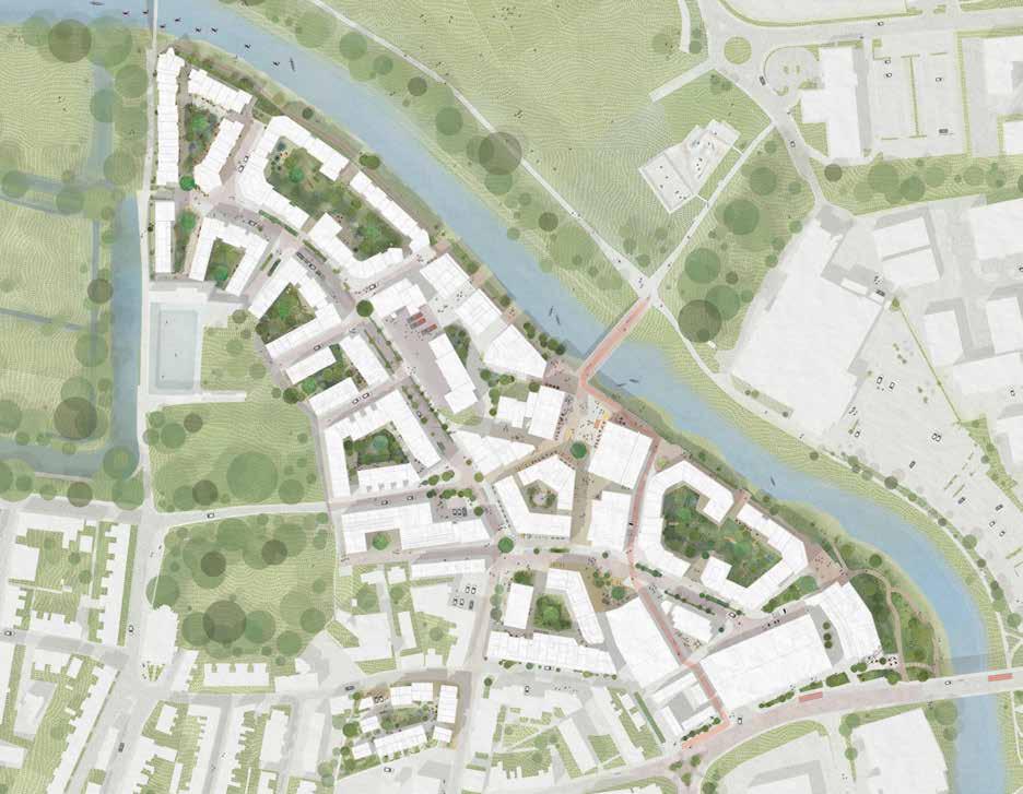
This section lays out the masterplan of the Phoenix, its block structure, street hierarchy, connectivity, mobility and movement. It sets out the location, use and scale of the neighbourhood’s buildings, as well as details about its public realm, including the squares, gardens, play areas, river walk and Belvedere, explaining how landscape-led place design determined the layout of the plans informed by context, key constraints, design principles and concepts and the Big Moves, all as identified and defined explicitly in previous sections. It also contains information and illustrations of the Phoenix’s community buildings such as the Soap Factory, the Every Hall and the Foundry Workshops and a brief overview of the future housing offer.
7.1 MASTERPLAN OVERVIEW
Advertisement
Building Plots
1 Jacobs Square Townhouses & Courtyard Homes Ash Sakula Architects
2 Pells Gardens Courtyard Material Cultures Architects
3 Spring Lane Courtyard & Mews Material Cultures Architects
4 Rowe Lane Courtyard & Mews Material Cultures Architects
5 Pells Lane Courtyard & Mews Mae Architects
6 Brook Street Co-Housing Archio Architects
7 The Foundry Healthcare Practice Mole Architects
8 Spring Gardens Apartments Al-Jawad Pike Architects
9 Phoenix House Human Nature Architects & Sustainable Construction
10 Phoenix Square Live Work & Creative Studios Ash Sakula Architects
11 Soap Factory Human Nature Architects & Sustainable Construction
12 Re-Use Centre & Apartments Periscope
13 Full Cycle Bike Shop & Courtyard Homes Rabble Architects
14 Co-Mobility Hub Periscope (architects) / WSP (transport)
15 Foreshore Apartments Adam Richards Architects
16 Phoenix Riverside Courtyard Homes Human Nature, Adam Richards Architects, TDO & Eurban (architects & timber specialists)
17 The Foundry Hotel, Roof Garden & Restaurant Al-Jawad Pike Architects
Al-Jawad
24 North Street Courtyard Homes Human Nature, Charles Holland Architects, TDO & Eurban (architects & timber specialists)
25 Springman Corner Apartments, Mole Architects
Public Realm
26 Thomas Paine Bridge Expedition Engineering (structural engineers), Paul Myles (design)
27 Foundry Yards Periscope
28 River Walk & Belvedere Periscope, Expedition Engineering (structural engineers)
29 Ouse Slipway
7.2 LANDSCAPE-LED PLACE DESIGN
Our approach to landscape-led place design is explained in Sections 2-4 of this document. The diagram responds to some of the key constraints, concepts and big moves explained inSsection 5.
Framing views
The building form, urban grain and streetscape of the new neighbourhood has been carefully considered so as to both frame existing views while creating key new views both in and out of the Phoenix.
Maximising connectivity & access
The masterplan stitches the Phoenix into the town and the landscape context, physically and then, in future, also socially, economically, and culturally.
Rain gardens
The courtyard gardens across the site provide space for large, set-piece, engineered rain gardens that, together with a network of smaller planning features protect residents and businesses from pluvial flooding. The amount of water storage is an important factor in determining the size of the courtyards.
Shared living
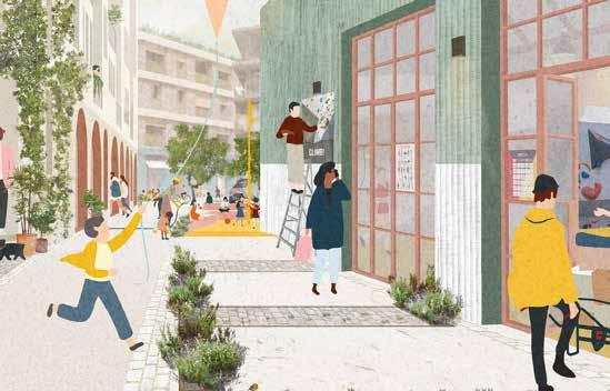
People housed at the Phoenix will primarily be living in courtyard blocks with shared gardens, play areas and storage, and with attractive rain gardens. There is also a network of public squares - shared spaces - for gathering and informal social mixing. People can and will experience many forms of social interaction in spaces across the site, building a palpable sense of neighbourliness, civility and community.
Flood wall & river walk
The flood wall houses a continuous river walk that runs from the Causeway bridge to Pells bridge. It ramps gently up to join the Belvedere at the centre of the Phoenix where it also extends as a mezzanine into the refurbished structures of the Every Hall and Foundry Workshops.
Biophilia: super-greening the urban environment
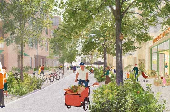
This is to bring new, natural life to the Phoenix, abundant greenery. Street trees, planted rain gardens and other SUDS, community gardens, urban farming, planters everywhere. The softer textures, colour, smells, insect and bird life, leaven the urbanity and connect us to natural landscapes beyond.
Landscape & the senses
The Phoenix aims to be a place that engages all of the senses: hearing, smell, sight, taste – but also the combinations of these as people experience place as a many-sided thing. Places have varying degrees of texture, colour, proportions, memory and history, old and new, quietude and noise, energy and calm, greenery and urbanity, wet and dry, natural or other smells.
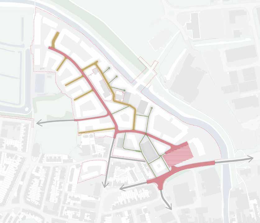
7.3 BLOCK STRUCTURE
of the Phoenix. For example, the massing of the buildings around the centre has been lowered to frame a view towards the castle. The edges of the site contain a number of carefully placed gaps which helps frame views of the surrounding landscape.
the entire length which could be extended into the town centre and onwards to Lewes Train Station in the future. The creation of the bridge at this location also creates a visual link to Lewes castle
Retention of the existing streets is a fundamental principle which shapes the masterplan. Keeping the historic street pattern has reduced embodied carbon which would have been expended creating new infrastructure (rather than upgrading the existing), ensured access for emergency vehicles to the fire station site and retained the historic links into the wider movement network.
The building form, urban grain and streetscape of the new neighbourhood has been carefully considered so as to both frame existing views while creating key new views both in and out
The river path, which ends at the northern edge of the site currently is extended south along the entire length of the river’s edge. This creates broad opportunities to access the river’s edge, increases connectivity into The Pells and sets up a future opportunity to extend further south (beyond the site boundary) towards the high street.
In order to connect North Street to the river path a series of east-west Mews Streets have been defined. These streets, being largely residential in nature will connect the entire neighbourhood to the river’s edge.
A bridge across the River Ouse creates a very strong connection between Lewes and Malling with the Phoenix en route. This route will be foot and cycle only with a dedicated cycle route
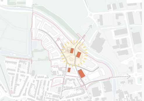
The Phoenix’s built heritage is of great historic value but also has great potential for adaptive reuse. These large structures lend themselves to public and employment uses which are active and, being at the centre of the neighbourhood, will define a ‘Neighbourhood Centre’.
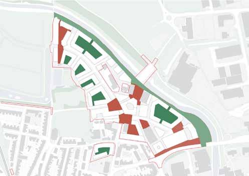
Each of these factors help to define urban blocks which are then further fragmented into buildings of various typologies and uses, each with its own approach to public and private space, amenity and playable space, fronts and backs and massing.
The result is a structure which is defined by a logic of landscape, wider connectivity and contextual integration.
Gap to create views in and out
The long river edge elevation is porous to allow for views in, out and through the site
Defensible space
Small front gardens encourage the inhabitation of building frontages
Shared courtyard garden
Communal gardens foster shared living and conviviality
Plot articulation
Blocks are broken down into individual plots, articulated on the building line
Prominent corners
Help create a sense of enclosure and encourage inhabitation in front of the building
Street hierachy
Clear legibility to network of streets
Floodable urban spaces
Functional response to flooding but also create a meaningful relationship between people and water
Open-sided blocks
Allow sunlight to penetrate deep into the garden spaces all day
Block Structure
These diagrams explain the process of designing the form and layout of the masterplan block structure.
Retain existing routes
The historic street pattern is used as a foundation for structuring the masterplan.
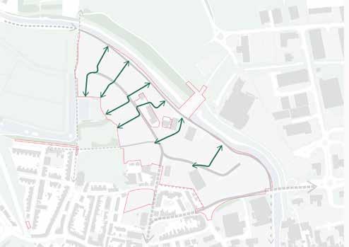

River front path
Link the Pells river walk to the Causeway, establishing a potential future link to the high street.
Mews streets
Connect to the river front with residential streets which break up the site and create views of the surrounding landscape.
Bridge to Malling Rec
Create a strong foot and cycle route connecting the town centre to Malling Rec via a new bridge.

Framing views
The building form, urban grain and streetscape of the new neighbourhood has been carefully considered so as to both frame existing views while creating key new views both in and out of the Phoenix.
Landscape infrastructure
A network of green and blue infrastructure has driven the scale and form of the open spaces.
Retention of historic structures
Key industrial heritage is retained and gives structure to a new Neighbourhood Centre to the neighbourhood.
Define block sizes
Urban blocks are defined which are further and more finely fragmented through detailed design.

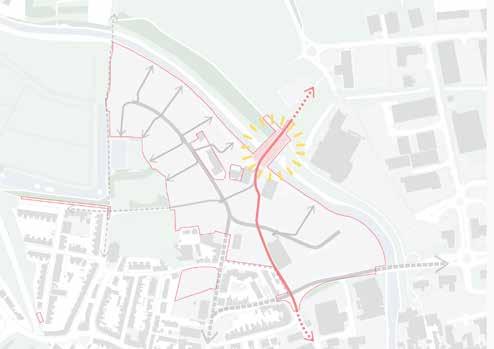
7.4 CONNECTIVITY, MOBILITY & MOVEMENT
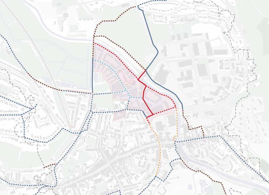
Four important connections
The River Front Path
Pedestrian route connecting the Pells river path to the Causeway. The path has three characters; a wild and green northern third, a centre third which is at higher level is called The Belvedere and a southern third which is close to the river foreshore.
The extension of the river path south beyond the Pells and as far as the Causeway, opens up the possibility of a future connection towards the high street by extending further south outside of this projects boundary.
North St & Brook St
North Street and Brook Street are the primary streets within the Phoenix neighbourhood by which all motorised vehicles will enter and exit. All residential streets feed off of North Street.
North Street, which is re-designed with walking and cycling in mind, leads to the far north of the site where there is a pedestrian link into the Pells.
Both streets link into the existing street connect adjacent to the Phoenix.
TheCauseway
Dedicated cycle route with pedestrian provision linking Malling Rec with a new foot and cycle bridge to the Phoenix and onwards towards the town centre.
New Vehicular Access to Phoenix
This access will be used by the majority of vehicles - both residents and vistors. It sits alongside the new cycle and pedestrian connections and Foreshore Park.
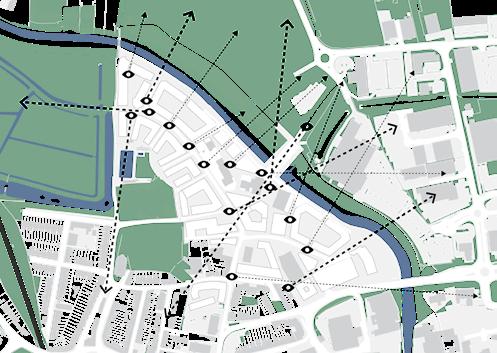
7.4.1 Wider cycling connectivity
Existing
Missing Connection!
The proposed Thomas Paine foot and cycle bridge will deliver a new connection between the Phoenix and Malling Rec which creates a new, direct route between the town and Malling via the established cycle route through the Rec. This trip would have otherwise been made along the eastern river path from Cliffe or via The Pells and Willey’s Bridge (which is not a cycle route and is very steep). This will also connect to the proposed new cycle route on the old railway line to Old Malling Farm.
Wider Cycle Connectivity Diagram
Designated Cycle Path or Other Surfaced Traffic Free Route On-Road Route with Lighter Traffic
Unsurfaced Off-Road Route
Useful Links to Push a Bike
Proposed Cycle Path (surfaced)

Proposed Useful Link to Push a Bike
Proposed On-Road Route with Lighter Traffic
Desirable Future Cycle Links (outside of project scope)
South Malling
7.4.2 Ouse Walk: The River Front
The Belvedere
The Belvedere is the centre of the riverfront and the place where the Thomas Paine Bridge connects to Malling Rec. The Belvedere and the bridge will offer views across and along the Ouse into and over Foundry Yards, to the Downs.

The Southern Boardwalk and The Foreshore Park
Walking south from the Belvedere, the boardwalk gently ramps down to riverbank level with a garden at the mid point for resting and enjoying the river.
At riverbank level a slipway for launching small boats and canoes adjoins the walk. From this point the Foreshore Park runs through the riverbank flora and links to the Causeway edge. There is also a safeguarded future link (outside of this project’s scope) which can go underneath the Causeway Bridge directly towards the town centre.
The Northern Boardwalk
Walking north from the Belvedere, the boardwalk ramps down slightly then levels to run along the riverside, connecting to Willey’s Bridge and the Pells.
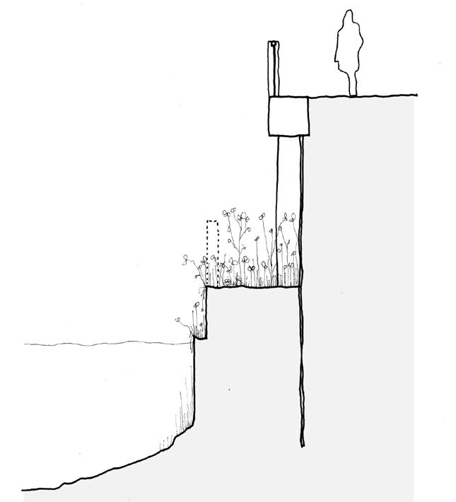
The Phoenix will be protected from fluvial (river) flooding by a new river wall. The riverfront walk has two different relations to the flood wall. The Belvedere sits on top of the river wall whilst the Northern and Southern Boardwalk sit on the outside of the river wall.


In both cases the new river wall is set back from the lower and now insufficient, existing river wall. This will leave a ‘shelf’ between the new and old river walls which will be allowed to be colonised by native riverine flora. It also acts as a safe place for animals to move along the river edge.
7.4.3 Street hierarchy
Vehicular Circulation
Private, refuse, servicing and emergency vehicle access.
Pedestrian & cycle priorityservicing / emergency vehicles only.
The low vehicle strategy which has been adopted at the Phoenix gives us an opportunity to make a neighbourhood where active travel by foot and cycle is the primary way of moving around and streets are spaces that are safe and attractive for pedestrians, cyclists and wheelers, as well as providing openness for people to enjoy.
There are three kinds of routes in the Phoenix; Streets which can be accessed by any vehicle but parking is limited to blue badge holders and 15 minute drop off bays, Mews which are vehicle free apart from emergency and servicing vehicles and Twittens which like the twittens of Lewes are small in scale and, in the case of the Phoenix, totally vehicle free.
Pedestrian & cycle priority + corporation villa’s resident vehicular access only.
CO-MOBILITY HUB
Route Typologies

‘Street’ Typology
Connection to wider network
‘Mews’ Typology
‘Twitten’ Typology
Three characters of routes
Street
Streets in this typology are places which have more space between buildings to allow for several modes of movement and inhabitation. Private vehicles as well as service vehicles can access and, in some cases, park or drop off.
Streets are not however vehicle priority streets. The design is intended to support active travel by foot and cycle, and wheelers. The width of streets also allows for generous tree planting and rain gardens which separate footways from carriageways.
Twitten
Twittens are entirely free of vehicular traffic, small in scale and animated by active edges, for instance in the case of the Soap Factory.
Twittens tend to link places and are therefore not long routes by nature and similar in character to cut-through routes found across Lewes.
Mews’ are residential spaces which support community life between buildings. They have only very occasional traffic by servicing or emergency vehicles and so are safe for children and adults to use as play and recreation spaces.
Some mews have rain gardens, planters and all are designed with soft edges or ad hoc personalised planting and seating.

7.4.4 Co-mobility services & the low traffic neighbourhood
The Phoenix provides appealing and affordable mobility services.
Comprehensive co-mobility services will provide alternatives to private car journeys.
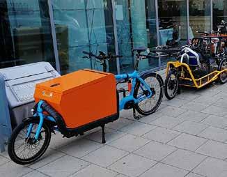
The co-mobility services for the Phoenix comprise an electric car hire service and car club with 50 electric vehicles with charging points; car-share application; E-cargo, E-bike and E-scooter hire and a last mile E-cargo bike delivery service, all based in the Co-Mobility Hub. E-shuttle bus services will also operate from here.
The Co-Mobility Hub will also provide a single location for long-term parking, with no through access for vehicles into the rest of the site. There will be controlled on-street parking on North Street, Phoenix Place, Brooks Street and Spring Gardens to allow for drop off and pick up and allocated blue badge holders, in addition to providing spaces for service vehicles to park closer to properties for repairs and larger deliveries.
There will also be a bike shop and repair workshop and distributed secure bike storage area.
Three bus lay-bys are being provided to give easy access to bus services
The Future of The Causeway
Bike Repair Shop Shop with bike parking spaces
Cycle Route Cycle path to Phoenix Place, Foundry Yards and beyond
CoMo Hub Vehicular access from the Causeway for residential and visitor parking
Bus Lay-bys Bus lay-bys with shelters, information and a refreshment kiosk with WCs
Foreshore Park
A linear green space with trees and rain gardens as well as seating and public art
Bike Shop
Street front location for the sale and repair of bikes.
CoMo Hub - Parking
Access is directly from the Causeway. This reduces traffic in the town centre and helps ensure low-traffic streets in the Phoenix.

Bus Lay-bys
Lay-bys and associated facilities.
CoMo Hub - Vehicle Hire
On the ground floor of the CoMo Hub, electric vehicles of all kinds will be available to residents of the Phoenix and Lewes in general.
PV Energy
Roof space is optimised for solar energy generation
Cafe A cafe / kiosk towards the rivers’ end of the Foreshore Park
CoMo Hub - Repair Repair and concierge services will operate from the Phoenix Place entrance and forecourt.
River Path
Access to the river path from the Causeway
Future Link
The river path opens up the possibility of a direct riverside link to the high street in the future
CoMo Hub - Last Mile Delivery
Last mile delivery centre for the whole neighbourhood.
7.4.5 Causeway access & mobility improvements
The Causeway currently provides a hard and impenetrable edge to the site. The masterplan creates new links for cyclists, pedestrians and wheelers into the site, as well as providing the new vehicular access into the Co-Mobility Hub and the bus lay-bys.
Pedestrian crossings improved with raised tables which make pedestrian / cycle movement easier and slow vehicles.
Westbound Bus Stops
Two stops (one to be used for standing at times) for westbound services.
Carriageway Surface Treatment
The Causeway surface material is changed from asphalt to help reduce speed and improve appearance.
Route
Town
Project ‘Red Line’
Illustrative plan showing future Causeway arrangement including bus lay-bys on both eastbound and westbound carriageways.
Eastbound Bus Stops
Three stops (one to be used for standing at times) for eastbound services.
Cafe / Kiosk With covered, outdoor seating.
Informal Crossing / Build Out Footway built out to slow traffic coming into town and provide and opportunity for informal crossing.
7.5 THE PUBLIC REALM
Squares and Yards will serve as connecting routes but also centres of social exchange.

The Waterfront and the series of spaces along the length of the river walk will provide opportunities for various types of engagement with the river.
Community Gardens are located throughout the neighbourhood.


