
13 minute read
FIGURE 7- CONSERVATION PRIORITY AREAS


• The Wading Bird Rookery CPA designation is increased from 6 acres in the 2011 Plan to nearly 23 acres to reflect shifts in roosting and nesting behaviors. The additions include a 50’ minimum buffer around each area of habitat.
• The largest single expansion of the CPAs on the island adds 733 acres of large, interconnected blocks of Maritime Oak Forest, including globally rare vegetative communities that are essential to this Plan’s Wildlife Priority Species.
• Verified by extensive ground-truthing, 111 acres are added to the Freshwater Wetland CPA designation. This reflects a more comprehensive knowledge of the freshwater ecosystems of the island.
• The Beach and Interdunal Swale CPA designation has been expanded landward to include an additional 572 acres, reflecting the critical importance of naturally vegetated systems in shoreline protection.
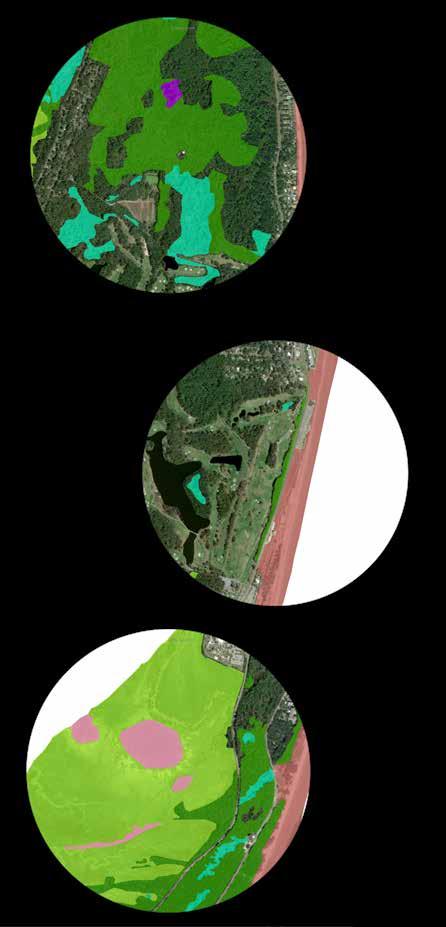
• The expansion includes those lands seaward of Beachview Drive, the “Beach Prairie”, backing the active dune system, which provide a rare experience of unobstructed ocean views along the beachfront. This area also offers exciting opportunities for ecological restoration of native maritime grasslands.
• Additional Coastal Marsh Hammock areas have been added in recognition of the habitat value these areas offer for priority species, including both natural and novel ecosystems.

Priority Vegetative Communities, a subset of the Conservation Priority Areas, were chosen for various reasons. Prior to the initial, 2011 adoption of this plan, Staff from Georgia DNR conducted detailed vegetative mapping on the Georgia coast and on Jekyll Island in particular. These detailed observations provided an understanding of the rarity of certain natural communities on Georgia barrier islands. Several of these communities were chosen as priority because they are globally rare, others were chosen because they are uncommon or rare on Georgia barrier islands. As referenced in Figure 3 (Page 23), the Vegetative Communities Map, these include:
17) Southern Hairgrass - Saltmeadow Cordgrass - Dune Fingergrass Herbaceous Vegetation 10) Southern Atlantic Coastal Plain Carolina Willow Dune Swale 2) Southeastern Florida Maritime Hammock 4) South Atlantic Coastal Shell Midden Woodland 7) Outer Coastal Plain Sweetbay Swamp Forest 8) Loblolly-bay Forest
Other natural communities were selected as priority because they are barrier island freshwater wetlands. These communities are somewhat more common on barrier islands but represent important habitats to barrier island wildlife that need a freshwater source. These include:
9) Red Maple - Tupelo Maritime Swamp Forest 20) Sawgrass Head 18) South Atlantic Coastal Pond
The following communities are typically associated with the beach and dune system. Where these communities are contiguous with the beach, they make up the Beach Community Association and, as early successional, open-canopy habitats, support some of the island’s most productive and diverse ecological assemblages. Due to the productivity of these habitats for small mammals, their predators, including bobcats, snakes, and raptors, are particularly reliant on them.
11) Atlantic Coast Interdune Swale 12) Live Oak - Yaupon - (Wax-myrtle) Shrubland Alliance 15) Sea-oats Temperate Herbaceous Alliance 22) South Atlantic Upper Ocean Beach
The 2020 update to the Conservation Plan adds Maritime Live Oak Hammock (1) to the Priority Communities due to the high Global Rarity Rank (G2) of this vegetative community and the threats it faces from development across the coastal Southeast United States (https://explorer.natureserve.org/Taxon/ELEMENT_GLOBAL.2.687074/Quercus_virginiana_-_(Pinus_elliottii_Sabal_palmetto)_-_ Persea_borbonia_-_Callicarpa_americana_Forest). Retaining and protecting large contiguous expanses of Maritime Live Oak Hammock, such as those that exist on Jekyll Island, is important for conservation of the associated biodiversity. This addition does not include Maritime Live Oak Hammock that falls on land classified in the context of Georgia law limiting the extent of development on Jekyll Island as Developed at the time of adoption of this Plan update.


In a few cases, CPA designations overlap with leased property, which is categorically classified as Developed land. For example, beach, dune, and interdunal swale are established on the southeast corner of the Days Inn leased property. Forested lands between the active sand dune system and leased parcels associated with the Hampton Inn property and the Ocean Oaks subdivision have been added to the CPAs. In addition, the Federal Aviation Administration leases a marsh hammock on the causeway harboring South Atlantic Coastal Shell Midden Woodland. The terms of lease agreements are therefore pertinent to these Conservation Priority Areas. The JIA will seek to negotiate additional protections in these circumstances, through amended, revised, or restated lease agreements, or through land transfers.
Pending implementation of a 2020 Golf Master Plan, this Conservation Plan may be amended prior to its next update to designate additional CPAs within areas currently occupied by golf course.
7.2- LANDSCAPE-SCALE IMPACTS
The landscape-scale evaluation is intended to assess potential impacts from projects that could have relatively large-scale or farreaching effects on natural resources of the Island. This Plan creates a strategy for conservation that prioritizes protection of large blocks of the remaining natural areas. Proposed projects that would impact substantial areas of undisturbed natural lands, further fragment management units, significantly alter wetland hydrology, or compromise the ability to adapt to climate change and sealevel rise would be considered landscape-scale impacts (i.e., a proposal for a new roadway that would result in unrecoverable loss or degradation of a Conservation Priority Area, as identified in this chapter.) Some potential projects could have less dramatic impacts at the outset, but over time they could cause an impact to a broad array of natural resources, and therefore be inconsistent with conservation objectives on the Island.
At the landscape scale, proposed activities on Jekyll Island must have no impacts to: • Historical fire patterns – A proposed development project that would preclude the use of fire as a management tool across the pine-dominated communities in the north end of the Island would be considered an incompatible, landscape level impact. Similarly, much of the Island is vulnerable to stand-altering fires, and the Comprehensive Fire Management Program provides an approach to limit exposure to this threat. Any proposed project that would interfere with Island-wide objectives for managing fire would be considered an incompatible landscape-scale impact. • Genetic flow of native species across the Island – Proposed development projects that would further separate the Island into genetically isolated fragments would be considered an incompatible landscape-level impact. • Wildlife movement patterns – Fragmentation impacts could cause changes in wildlife movement that could be deemed inappropriate. Any project that would significantly reduce or eliminate the potential for wildlife movement from one area of the Island to another would be incompatible with the objectives of this Plan. • Beach dynamics – Many of the Wildlife Priority Species listed in Chapter 4 depend on the Beach, Dune, and Interdunal Swale communities. Disturbances from proposed projects that could disturb the nesting, wintering, or migratory stopover of shorebirds, or nesting sea turtles could be deemed a landscape-scale impact that would result in a rejection of the proposed project as incompatible with the objectives of the Conservation Plan. Further, development projects must not jeopardize the long-term integrity of natural dune systems as the first order of beach protection from storm events and erosion across the Island. Projects that fail to provide appropriate and reasonable accommodations, to prevent retreating shorelines from leading to the loss of natural dune systems, would be incompatible with the objectives of the Conservation Plan. • River, marsh, or marine hydrology or flow patterns – Landscape-scale impacts to hydrology would be those that would have far-reaching or systemic impacts to the function of existing wetland systems, or systems that have a predictable/ achievable prospect of becoming wetlands in the foreseeable future either through restoration or due to sea-level rise. Direct or indirect impacts will be considered. These projects would not be acceptable or compatible with the objectives of the Conservation Plan. • Freshwater (surface and groundwater) hydrology – Freshwater wetland systems are a relatively rare feature in the barrier island landscape with an outsized role in ecosystem function and diversity. As such, any unmitigated loss or degradation of predominately natural freshwater wetlands will be considered a landscape-scale impact that is incompatible with the objectives of the Conservation Plan. • Population viability of native plants and animals – Viable populations of plants and animals remain so through the ability to withstand short-term and long-term perturbations such as weather extremes, disease, or predation pressure, roadway mortality, and habitat transformations associated with climate change. Projects which would be expected to jeopardize the ability of otherwise stable populations of plants and animals to withstand environmental stressors would be considered an incompatible, landscape-level impact. • Adaptability to sea-level rise – The ability of vegetation communities to move and reestablish themselves across the landscape over decadal timeframes in response to sea-level rise will contribute to the resiliency of ecosystems and their biodiversity. Development projects which would significantly reduce the capacity of uplands to accommodate colonization by plant communities associated with brackish wetlands and saltmarsh, within designated sea-level rise planning parameters, would be incompatible with the objectives of this Plan. ENVIRONMENTAL ASSESSMENT
7.3- LOCAL/SITE-SCALE IMPACTS
The review of local/site-scale parameters is intended to assess potential environmental impacts that may have influence on one or more ecological communities in the vicinity of the proposed project. Potential design changes or alternative locations for proposed projects that could cause significant local/site-scale natural resource impacts must be considered, and, if necessary, the project may be deemed inherently incompatible. An EAP review will specify project modifications required for a favorable EAP determination of compatibility. Recommendations that go beyond the essential requirements will also be provided. An example of a local-scale impact would be one in which changes in wetland hydrology could, over time, impact wetland function in an adjacent marsh. Site scale impacts could result in loss of native vegetation, or the growth of exotic species that could reduce biological diversity near the proposed project. The potential must be considered for incremental impacts or secondary impacts that could ensue from proposed activities. Requirements and recommendations provided in the EAP Report may go beyond design elements to address considerations including construction management and aspects of operations pertaining to conservation, such as waste and lighting.
At the local/site scale, proposed activities on Jekyll Island must avoid, or minimize if unavoidable, impacts including, but not limited to: • Natural resource management activities – The Oobjectives outlined in Chapter 5 provide the basis for maintaining or restoring natural systems on the Island, and their success should not be compromised by future development proposals. The approach to management is built on a concept of managing relatively large tracts of natural lands. A proposal for a new development parcel that would segment, or fragment natural communities would be considered incompatible. • Preservation of historic and archaeological resources – Proposed activities should avoid disturbance of known historic or archaeological resources and conduct a phase 1 archaeological survey for sites that have not been previously assessed unless deemed by JIA Historic Resources Division staff to be unlikely to contain significant resources. If phase 1 surveys discover significant resources, conditions of project advancement will be coordinated directly through the Historic Resources staff in coordination with the State Historic Preservation Office (SHPO) and the JIA Design Review Group. The EAP Review Team will defer to the senior staff person overseeing the JIA Historic Resources Division to determine when resources are sufficiently valuable to warrant protection, requirements for interagency coordination, and applicability of any state or federal laws in this arena. • Natural hydrology and existing drainage basins – Alterations to historical drainage patterns have been conducted on the Island in the past, and opportunities for restoration of these impacts are suggested in several chapters of this Plan. Additional impacts to surface or groundwater flows, or proposed projects that would preclude the implementation of restoration activities to improve the function of freshwater or saltwater wetlands would be considered unacceptable local impacts. • Water quality, with particular consideration of nutrients in receiving waters – Proposed development projects must provide a landscape management plan that will prevent high-nutrient discharge and a plan for treatment of other stormwater constituents that could degrade water quality, such as heavy metals, sediments, oil and grease, and pesticides and herbicides.
New development, construction, and renovation will be strongly encouraged to utilize Green and Sustainable Technology and, where appropriate, achieve certification through LEED, Green Globe, Georgia Peach or other environmental certification programs. Proposed development projects that do not include environmental certification must provide an explanation to the Design Review Group as to why certification is not practicable.
• The structure, composition and abundance of native plant and animal communities – Proposed development projects must minimize impacts to natural communities. These impacts could be direct, such as new development on a tract of existing natural lands. Or they could be indirect, such as when the development on one parcel causes a shift in vegetation structure or composition on an adjacent parcel as a result of the spread of exotic plants, changes in exposure to sunlight, or alterations in wind, salt or fire patterns. Though it is assumed that new development will cause the loss of some natural vegetation, these losses should occur along the edges of tracts of natural communities (and management units), not fragment existing systems, and minimize the footprint of disturbance, both direct and indirect. • Wetland function and extent – Saltwater, brackish, and freshwater wetlands are identified as CPAs, and impacts upon them should be avoided. • Local movements of wildlife – Proposed development projects that are likely to fragment otherwise intact natural systems would be expected to impact local movements of wildlife. Such projects should be avoided, or their affects minimized by specific design elements. • Protected species habitat – Select habitats used by priority species are mapped as CPAs in Figure 7 (Page 88). These habitats should not be impacted by proposed development projects in any way that would compromise their capacity to support priority species. ENVIRONMENTAL ASSESSMENT
7.4- REGULATORY CONTEXT
Several other Jekyll Island Ordinances are considered in the EAP review. Likewise, the State of Georgia’s Coastal Marshlands Protection Act and Shore Protection Act provide protection of tidal marshes and sand dunes, beaches, sandbars and shoals that are particularly important natural resources on the Island. Because of the presence of several federally listed species of wildlife (e.g., loggerhead sea turtle, green sea turtle, piping plover, wood stork), the Endangered Species Act is also germane to this review, as is Section 404 of the Clean Water Act because of the extent of federally-jurisdictional wetlands. The federal Coastal Barrier Resources Act discourages development by restricting federal expenditures and assistance, such as flood insurance, within designated areas. These acts and ordinances have their own specific requirements that must be adhered to, and they may also inform the EAP review. Each act or ordinance may provide specific measures to avoid and minimize environmental impacts. The EAP review will assure that necessary permits or approvals required under existing regulations and ordinances have been obtained, including:
1. Jekyll Island Ordinances including but not limited to: • Jekyll Island Land Development and Use Regulations • Beach Lighting Ordinance
2. Tree Protection Ordinance 3. Coastal Marshlands Protection Act 4. Shore Protection Act 5. GADNR EPD Coastal Stormwater Supplement to the Stormwater Management Manua
6. Section 404 of the Clean Water Act
7. Endangered Species Act 8. Coastal Barrier Resources Act
Jekyll Island Ordinances
https://www.jekyllisland.com/jekyll-island-authority/ordinances/
Coastal Marshlands Protection Act
http://rules.sos.state.ga.us/gac/391-2-3?urlRedirected=yes&data=admin&lookingfor=391-2-3)
Shore Protection Act
https://law.justia.com/codes/georgia/2015/title-12/chapter-5/article-4/part-2/
Endangered Species Act
http://www.fws.gov/laws/lawsdigest/esact.html
Section 404 of the Clean Water Act
https://www.epa.gov/cwa-404/overview-clean-water-act-section-404)
Coastal Barrier Resources Act
https://www.fws.gov/CBRA/


