The Plan was funded in FY 2022-23 Sustainable Transportation Planning Grant Program under the grant category Sustainable Communities Competitive.
Thank you to all who participated and supported the development of the City of El Centro Imperial Avenue Complete Streets Plan and a special thank you to Susan Chasang on behalf of the Sister Evelyn Mourey Center and volunteers.
Acknowledgements
City of El Centro
Andrea Montaño, Project Manager
Angel Hernandez, Community Development Director
Felix De Leon Jr., Principal Engineer
Abraham Campos, City Engineer/Public Works Director
KTUA
Joe Punsalan, Principal
Jacob Leon, Senior Associate
Morgen Ruby, Senior Planner
Isabel Pérez, Planner and Designer
Katherine Padilla & Associates, Inc. (KPA)
Katherine Padilla Otanez, Principal
Jessica Padilla Bowen, Senior Associate
Xavier Sibaja, Project Manager
Michael Baker
Ryan Zellers, Senior Transportation Planner
Jacob Swim, Senior Transportation Planner
Caltrans
Virginia Mendoza, Associate Transportation Planner
Omar Flores, Regional Grant Coordinator/Associate Transportation Planner
Alexander Araiza, Grant Manager/Associate Transportation Planner
Jacob Burkholder, Associate Transportation Planner
City Council
Tomás Oliva
Sonia Carter
Sylvia Marroquin
Claudia Camarena
John ‘Marty” Ellett
Planning Commission
Jorge Perez
Ashley Bertussi
Sergio Lopez
Aaron Popejoy
Andy Alvarez
Ramiro Urias
Jeffrey Chan
Project Advisory Committee
Ashley Bertussi
John Beltran
Lourdes Cienfuegos
Gustavo Gomez
Carlos Juarez
Sylvia Marroquin
Susana Simo
Natalie Torres
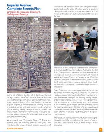
1 Introduction
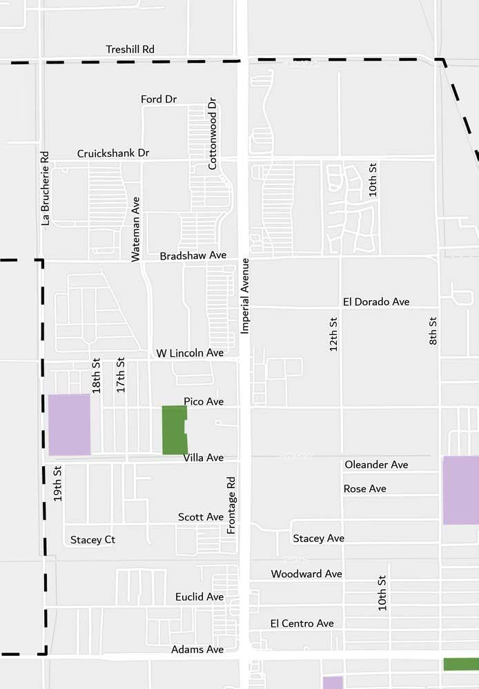
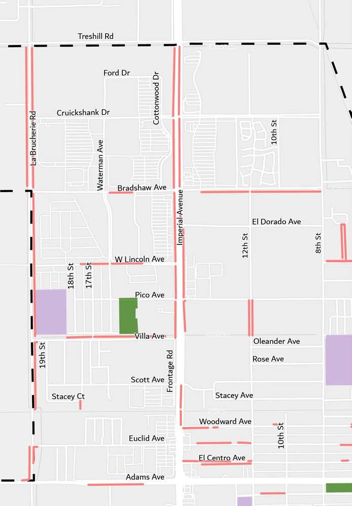
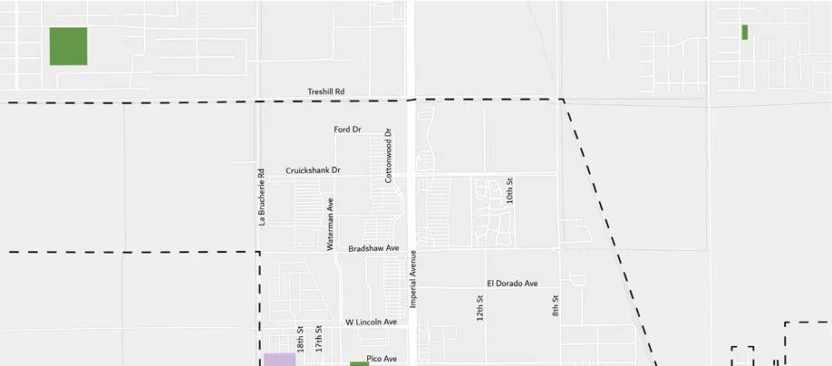
1.1 Study Area
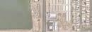
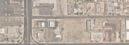
Located in Southern California, El Centro is the largest city in Imperial County. It is located just over 100 miles east of San Diego and 20 miles north of the Mexican city of Mexicali, the closest border crossing, and 30 miles south of the Salton Sea. El Centro is conveniently located near rail lines and Interstate 8 (I-8) providing an east-to-west connection to neighboring cities while State Route 111 (SR 111) provides a north-to-south connection.
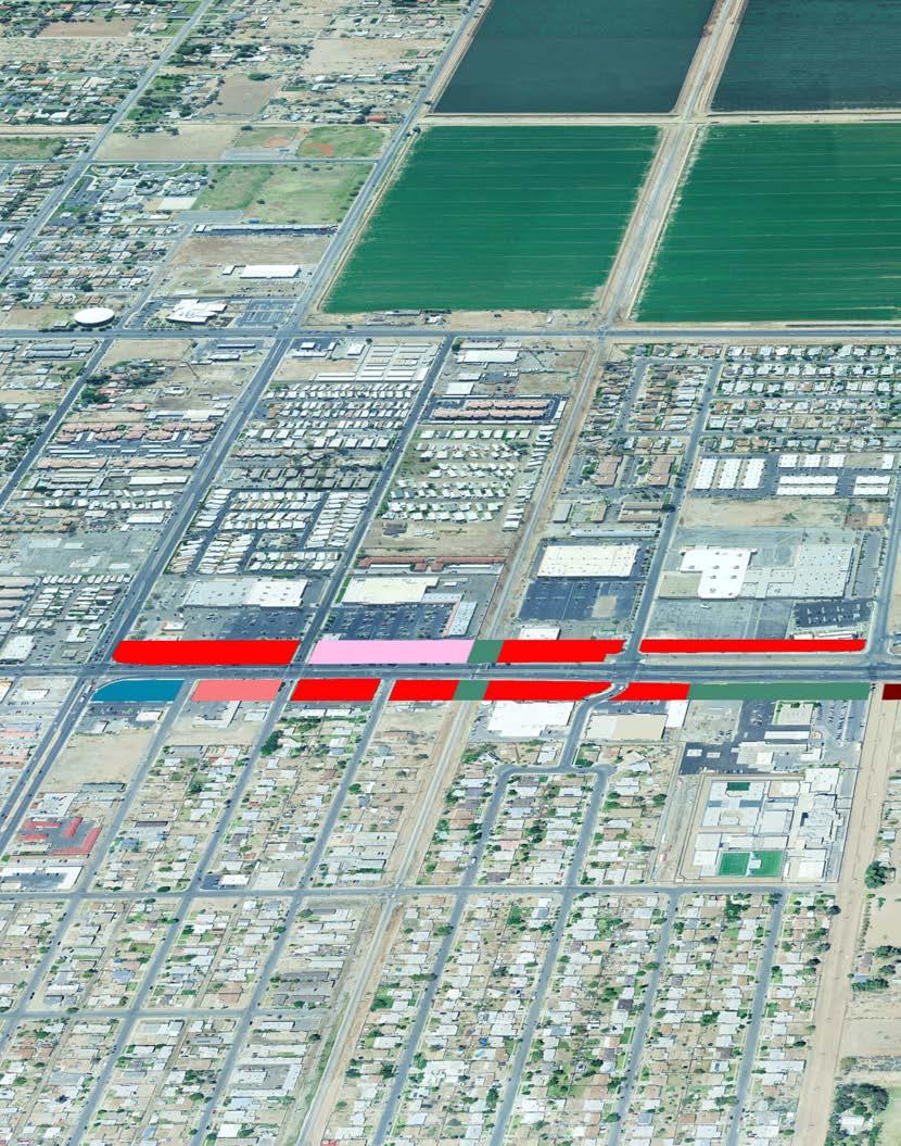
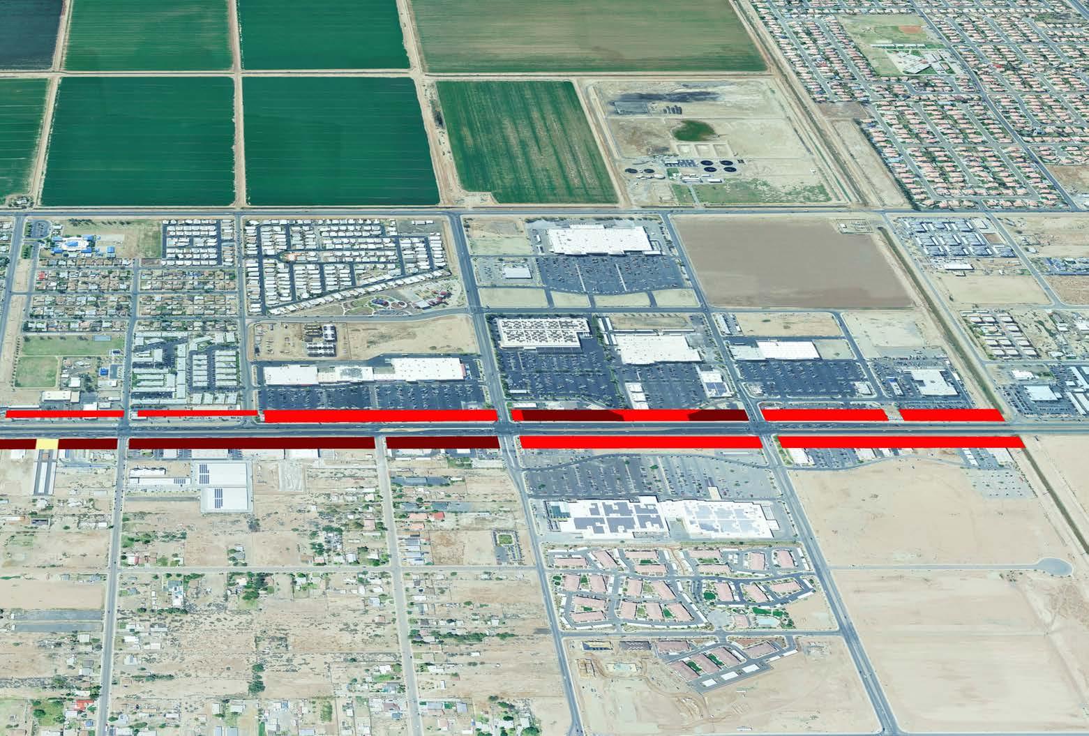
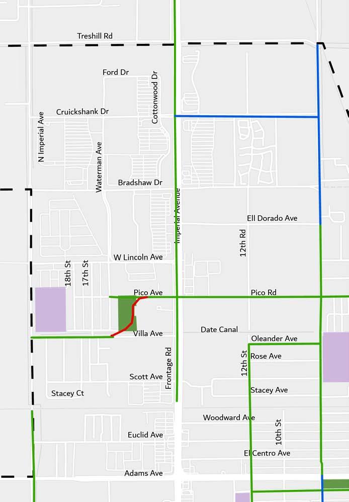
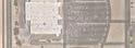
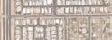
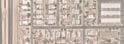
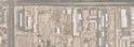
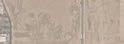
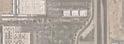
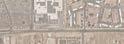
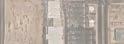
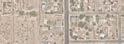
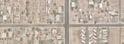
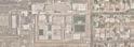
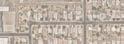
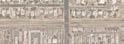
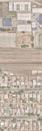
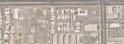
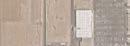
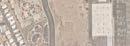
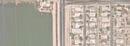
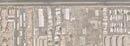
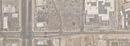
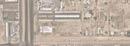
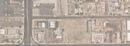
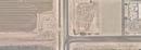
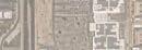
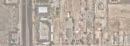
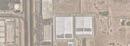
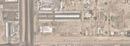
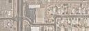
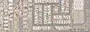
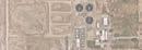
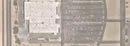
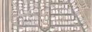
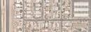
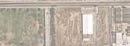
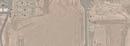
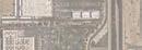
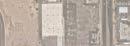
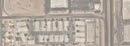
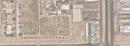
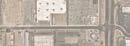
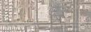
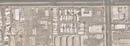
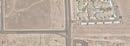
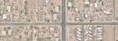
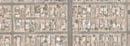
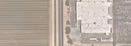
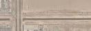
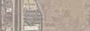
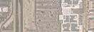
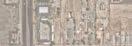
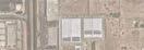
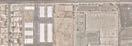
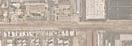
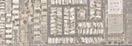
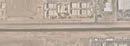
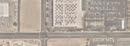
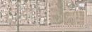
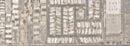
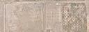
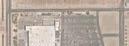
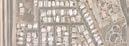
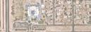
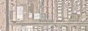
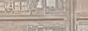
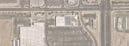
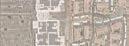
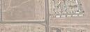
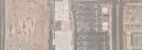
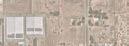
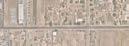
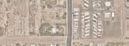
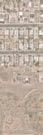
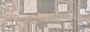
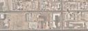
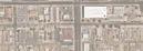
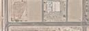
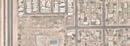
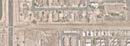
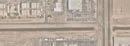
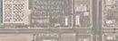
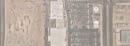
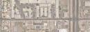
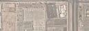
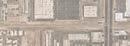
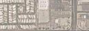
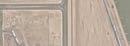
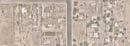
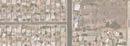
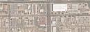
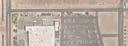
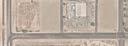
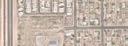
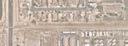
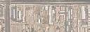
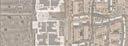
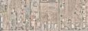
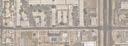
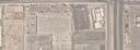
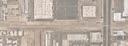
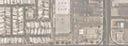
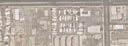
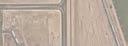
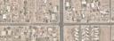
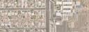
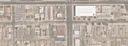
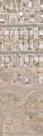
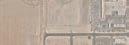
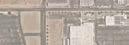
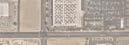
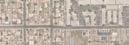
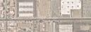
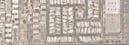
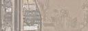
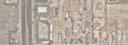
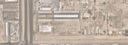
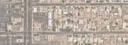
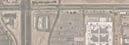
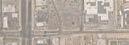
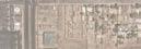
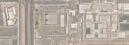
This Complete Streets Plan (CSP) focuses on a portion of Imperial Avenue, which is prioritized as a major highway and it is the backbone of El Centro’s transportation network as it bisects El Centro and creates a primary northto-south connection. Imperial Avenue serves as a primary commercial corridor while also connecting the community to public facilities, places of cultural significance, employment opportunities, and medical care. It is important to note the significance of El Centro’s core urban and metropolitan area within the Southern California Border Region as it is a major resource to El Centro and neighboring communities. The study area is highlighted in Figure 1-1
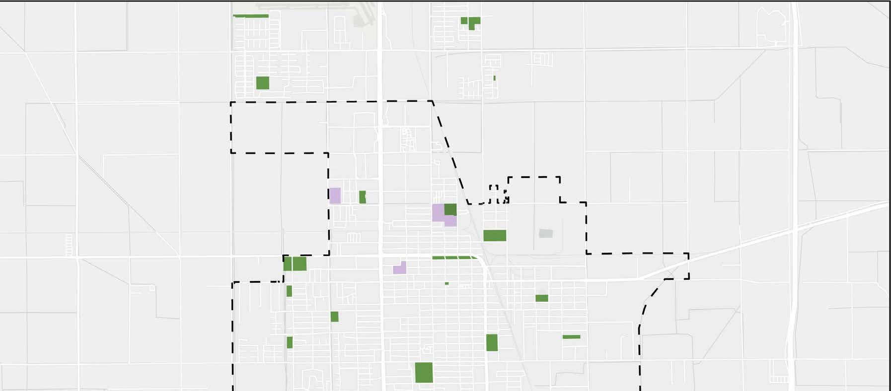
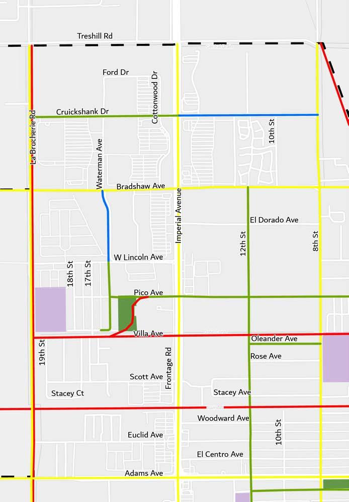
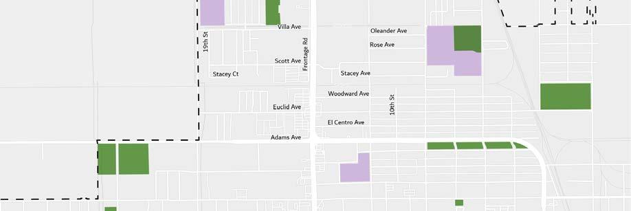
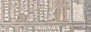
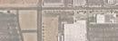
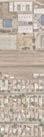
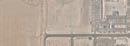
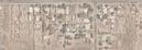
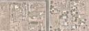
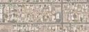
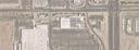
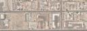
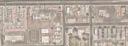
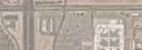
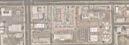
Figure 1-1: City of El Centro Map
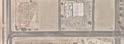
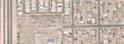
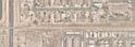
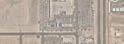
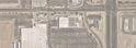
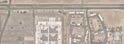
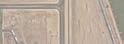
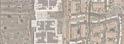
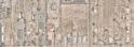
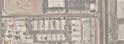
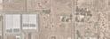
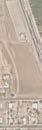
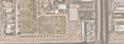
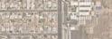
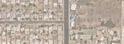
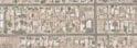
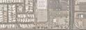
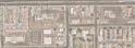
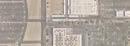
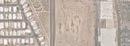
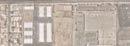
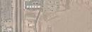
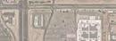
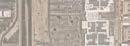
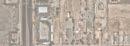
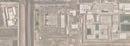
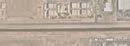
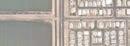
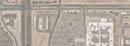
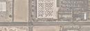
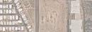
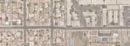
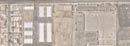
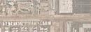
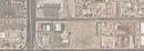
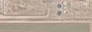
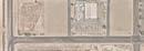
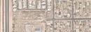
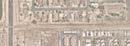
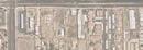
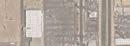
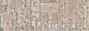
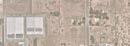
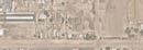
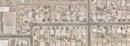
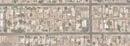
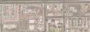
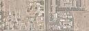
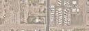
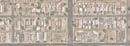
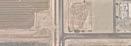
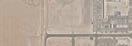
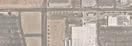
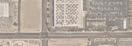
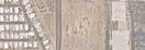
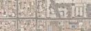
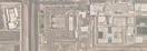
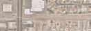
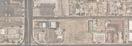
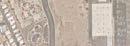
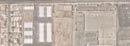
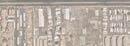
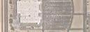
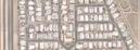
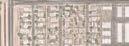
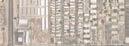
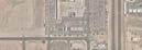
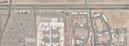
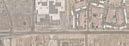
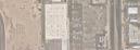
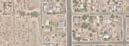
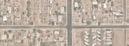
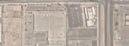
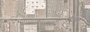
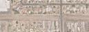
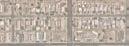
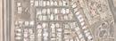
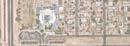
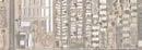
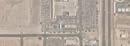
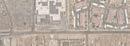
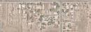
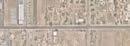
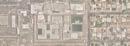
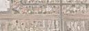
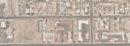
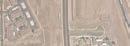
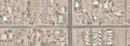
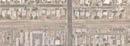
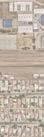
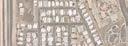
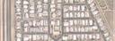
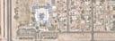
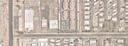
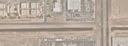
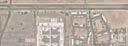
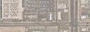
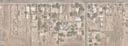
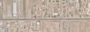
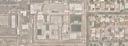
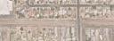
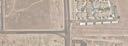
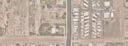
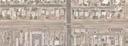
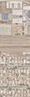
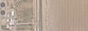
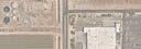
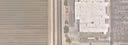
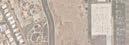
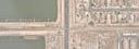
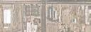
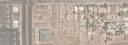
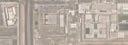
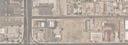
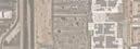
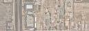
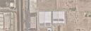
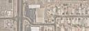
Figure 1-2: Study Area Segments
City Boundary
Study Area Boundary
Segment A
Segment B
Segment C
Schools
Parks
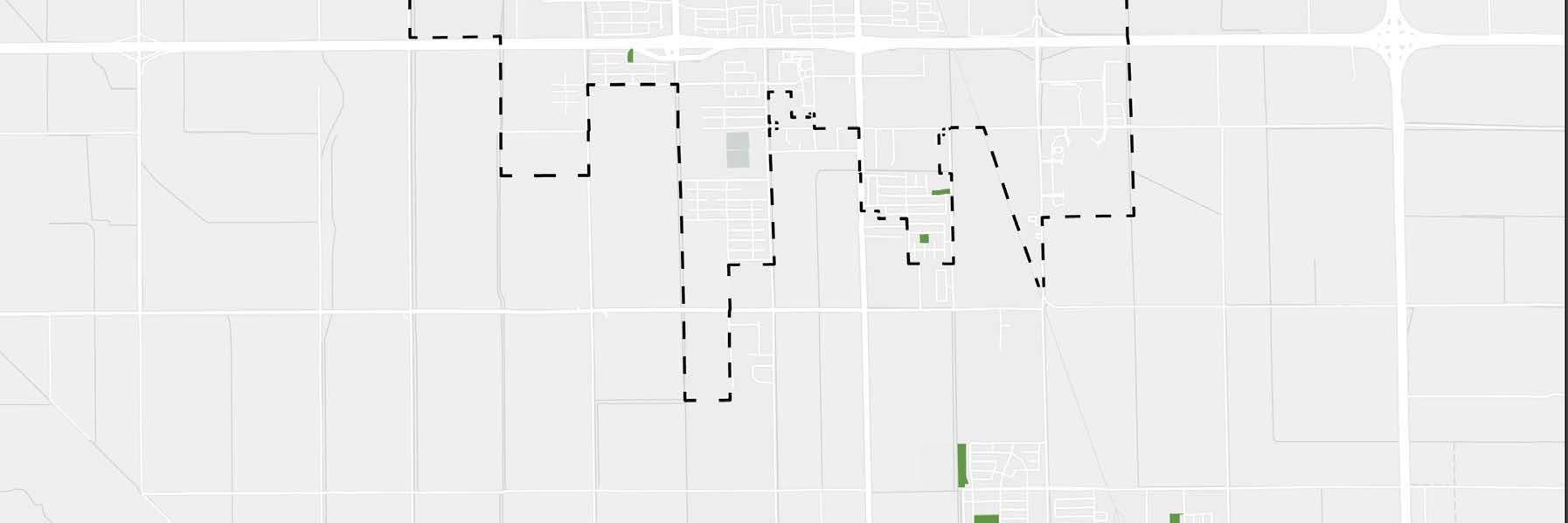
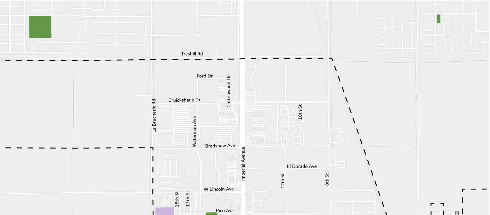
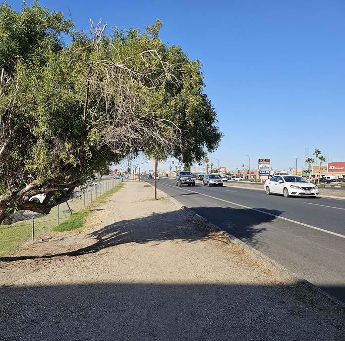
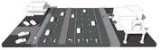
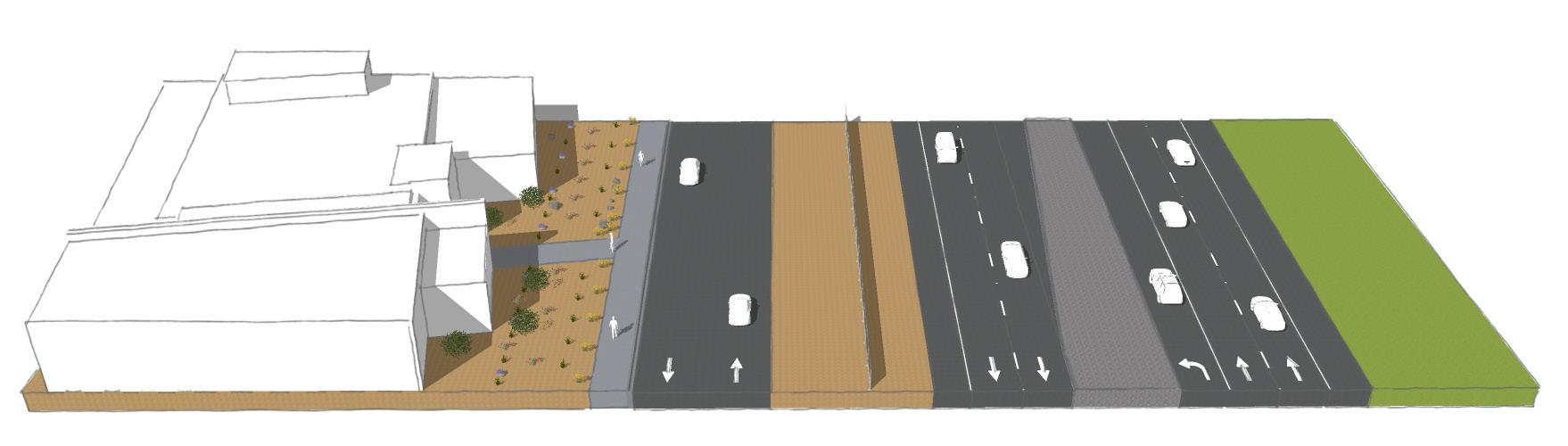
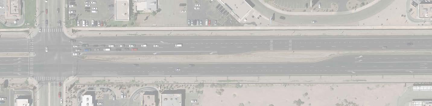
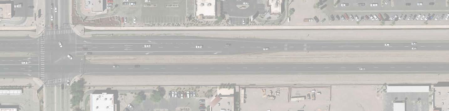
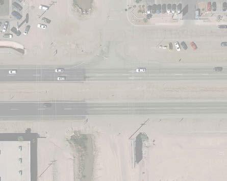
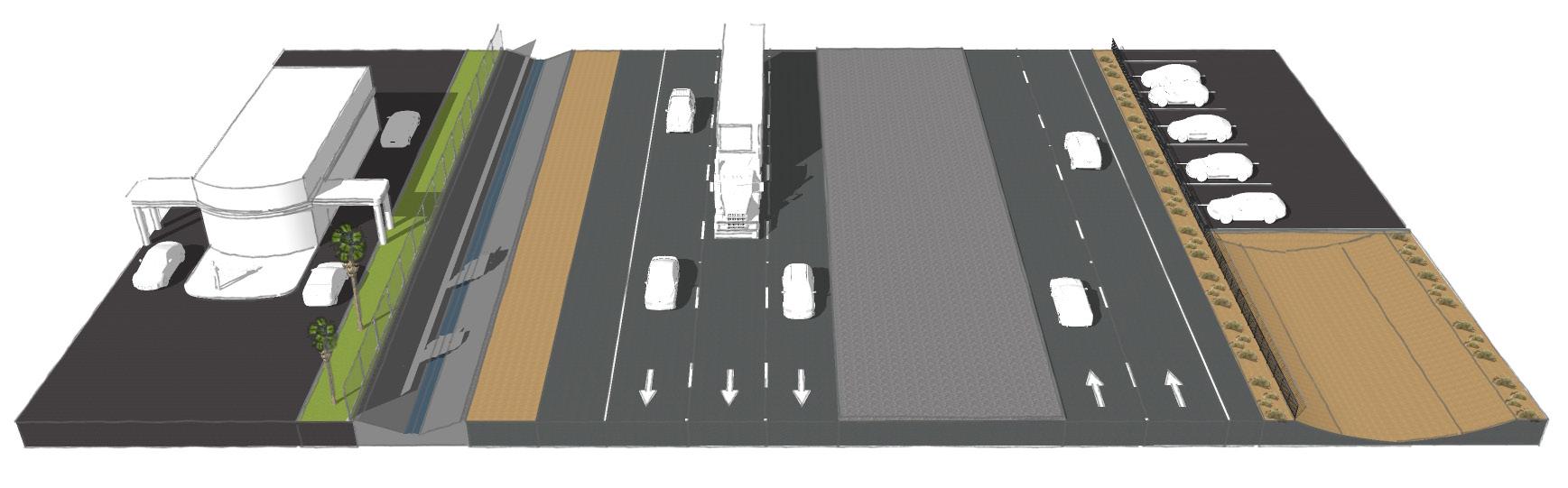
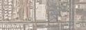
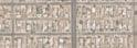
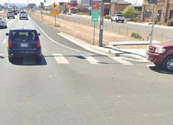
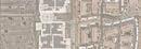
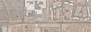
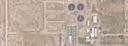
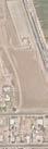
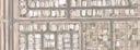
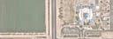
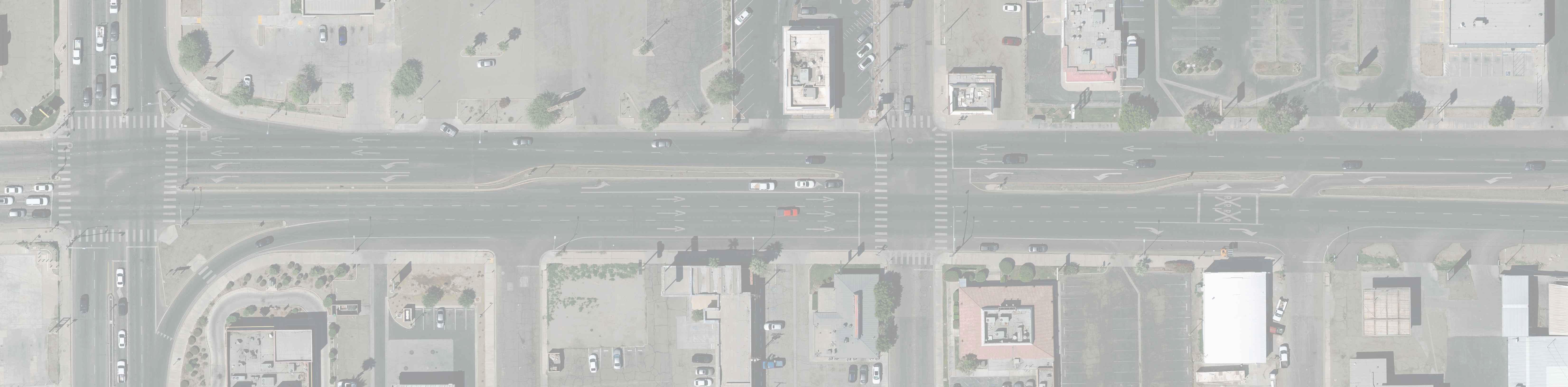
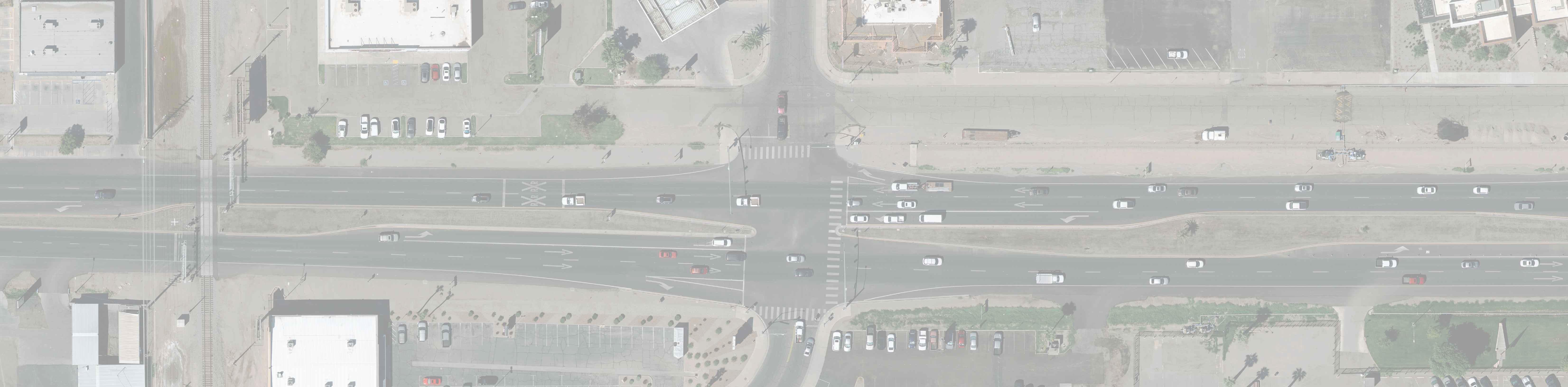
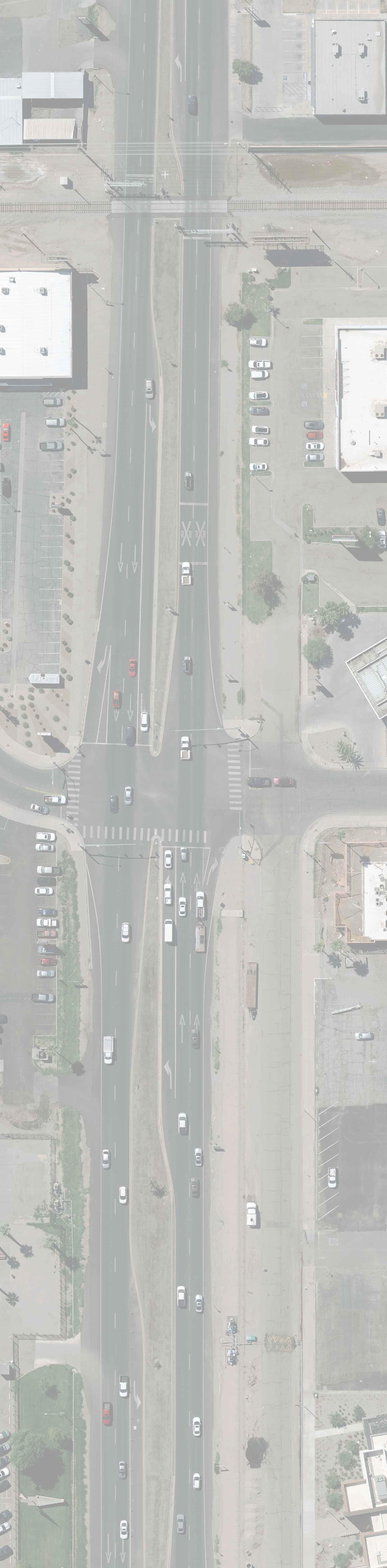
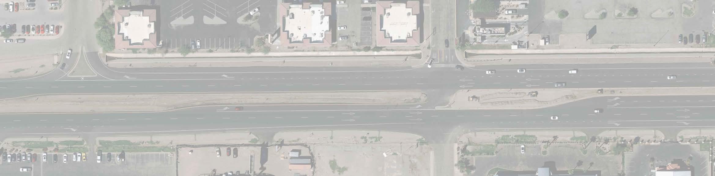
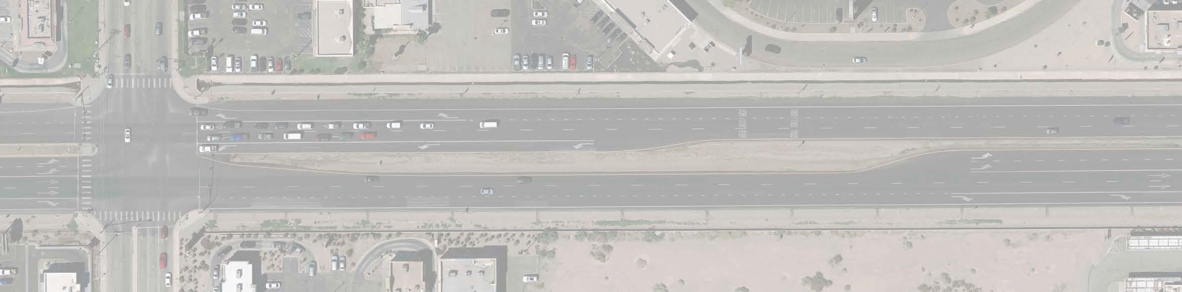
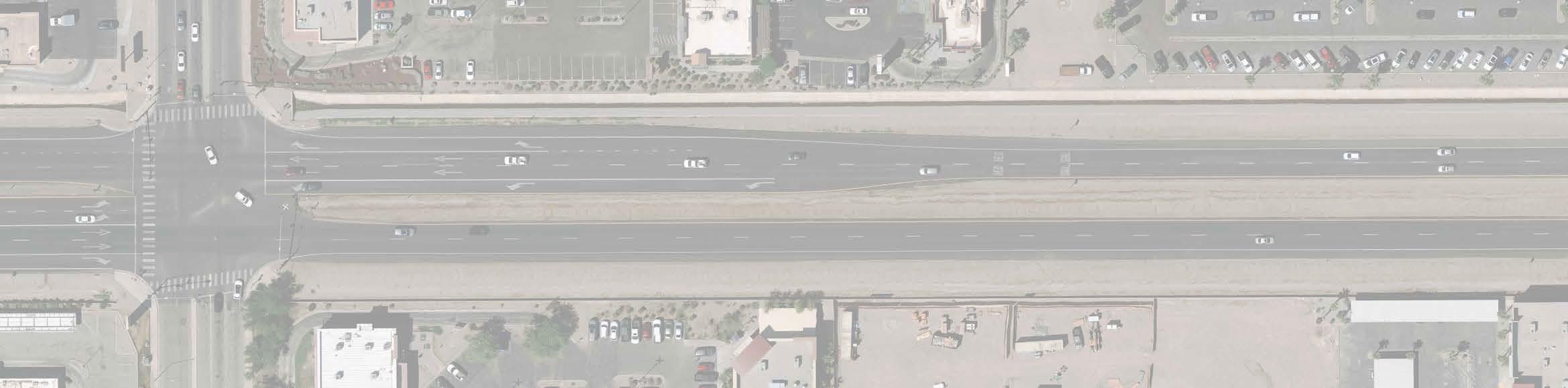
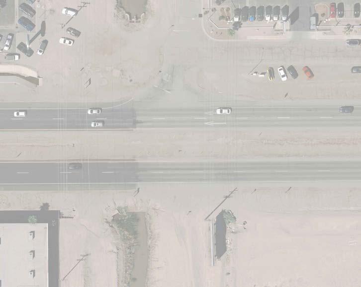
The study area consists of a 1.5 mile stretch of Imperial Avenue, or State Route 86 (SR 86) from Treshill Road to Adams Avenue.
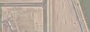
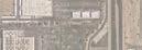
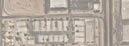
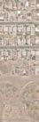
The study area for the CSP was broken down into three segments which are shown in Figure 1-2 and described in Table 1-1. Each segment has unique roadway conditions:
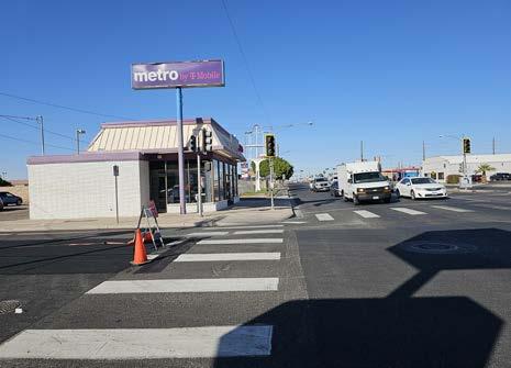
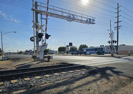
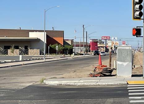
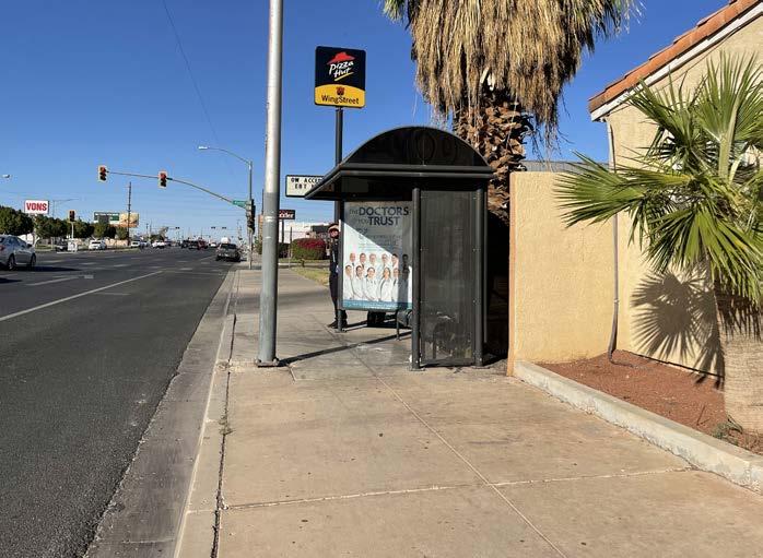
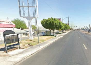
Segment A has existing sidewalks, bus shelters, raised narrow medians, wide travel lanes, and a railroad crossing.
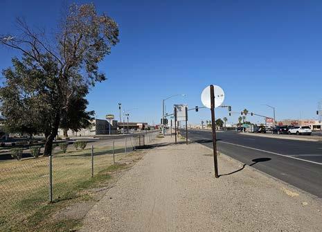
Segment B is characterized by a frontage road on the west side, a mixture of raised and earthen medians, and a lack of sidewalks.
Segment C is characterized by wide earthen medians, a lack of sidewalks, and undeveloped shoulders with an earthen drainage channel on the east side and a channelized flood control system on the west side.
Table 1-1: Study Area Segment Extents
Study Area Future Relinquishment
This CSP acknowledges that Caltrans has ownership of the study area at the time of its development. Implementation of the CSP is recommended once the study area is relinquished to El Centro. While El Centro anticipates gaining control of the study area in the future, Caltrans reviewed and provided guidance — included in Appendix A.1.
Martin Luther King Elementary
Fraizer Field
Carlos Aguilar Park
Lincoln Elementary Adams Park
Sunflower Park
McKinley Elementary Kennedy Middle School Town Square Park
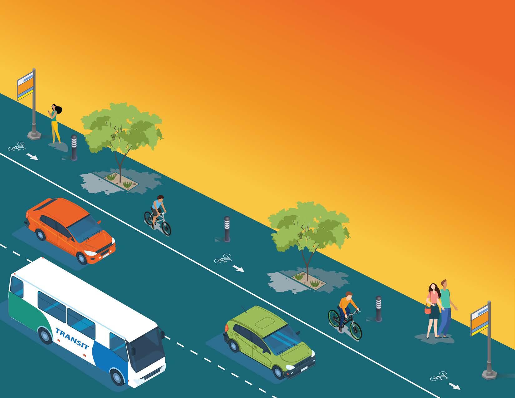
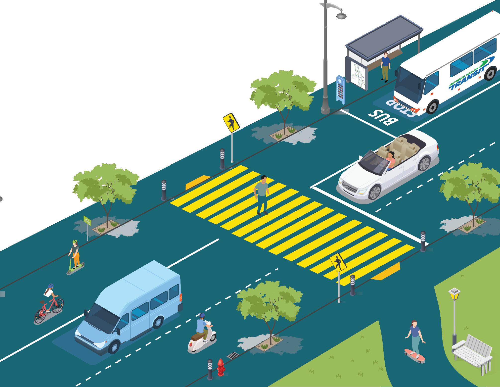
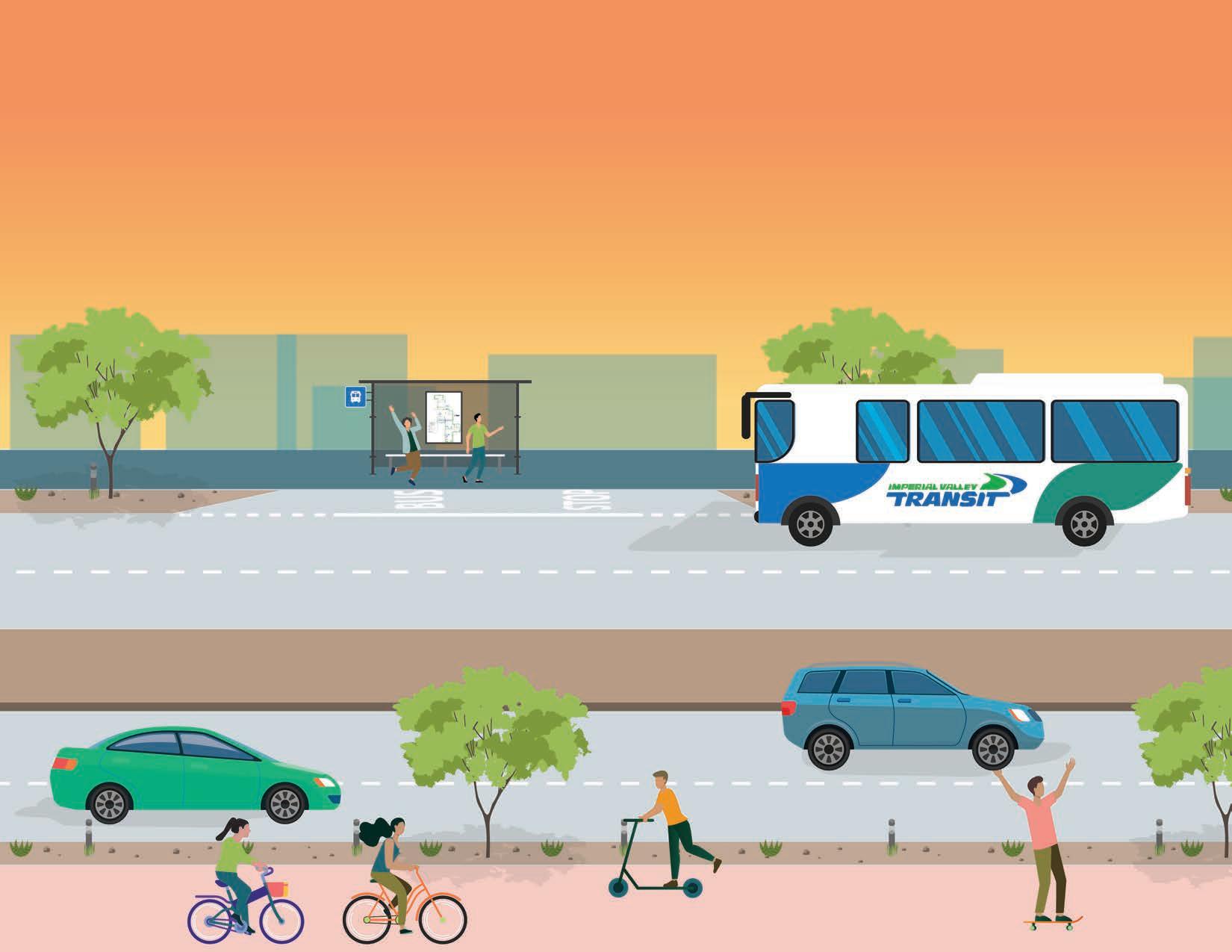
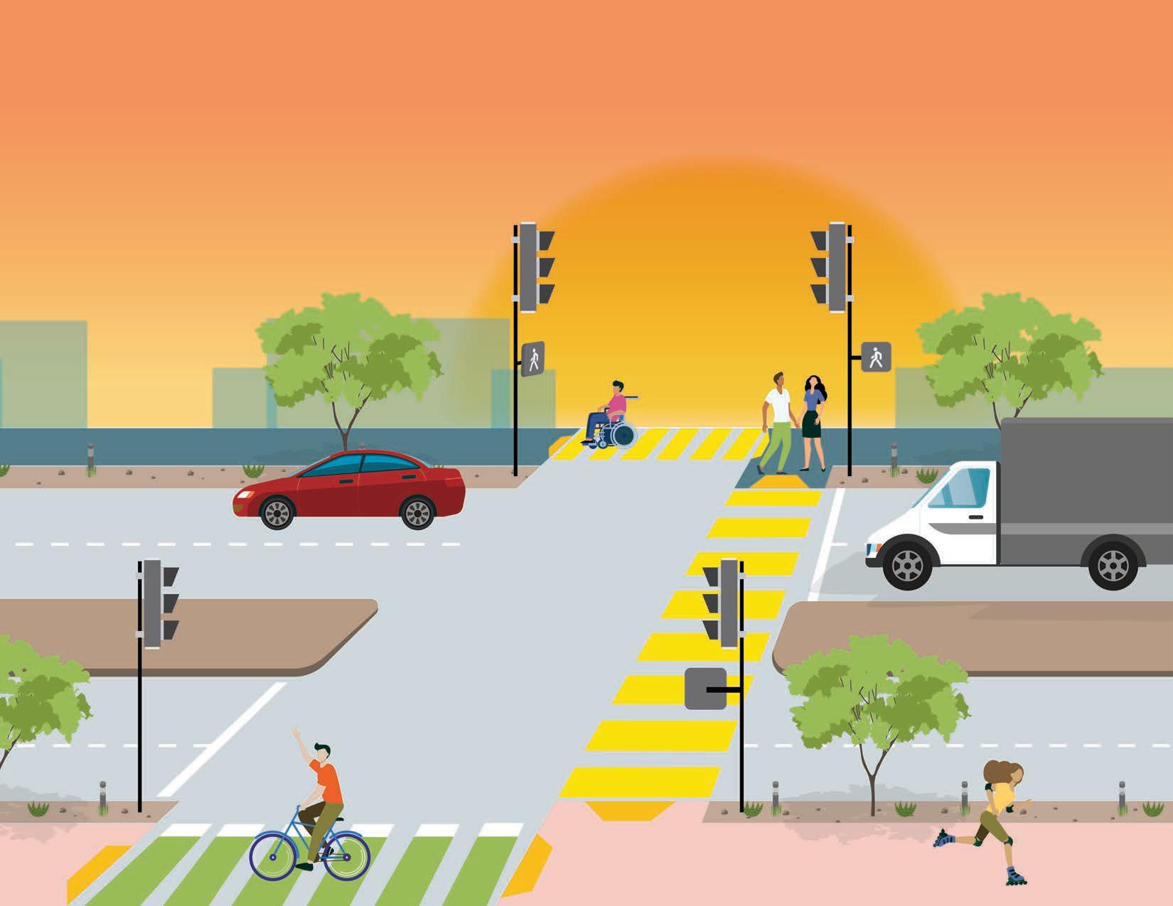
1.2 What are Complete Streets?
Complete Streets are planned, designed, and constructed to be safer, to improve access, and to strengthen community connections for all users and all modes of transportation.1 Complete Streets prioritize space for all pedestrians, bicyclists, transit users, and motor vehicle drivers of all ages and abilities within the public right-of-way. Complete Streets may also include components that increase comfort and attractiveness for roadway users through the addition of urban greening, public art, and gathering spaces.2
Special emphasis is placed on underserved and underinvested areas which are low-income and vulnerable communities facing often outdated street treatments. Complete Streets can be achieved through investment into traffic calming treatments, amenities for all road users, and maintenance to achieve a safe, comfortable, and welcoming street environment.
The Imperial Avenue CSP aligns efforts with the Caltrans Design Information Bulletin Number 94 (DIB-94): Complete Streets Contextual Design Guidance.3 The DIB-94 identifies and provides Complete Streets design guidance, best practices, and standards for the development of Complete Streets on the state-controlled road network — along with supporting policies and procedures.
Mobility for all modes of transportation
Mobility for people of all ages and abilities
Sustainable and green infrastructure
Safe, comfortable, and attractive spaces
1.2.1 Complete Streets Benefits
Creating Complete Streets has numerous benefits for pedestrians, bicyclists, drivers, and transit riders of all ages and abilities. Benefits are not exclusive to transportation users and can be experienced by adjacent homes, businesses, and key destinations.
Safety
and Wellness Economic Prosperity
A key benefit of planning, designing, constructing, and maintaining Complete Streets is the enhancement of safety for all roadway users. This CSP is the first step in planning for and designing Complete Streets that include traffic calming measures such as high-visibility sidewalks, bicycle lanes, pedestrian signals, among other measures. Construction and maintenance of Complete Streets help encourage good driver behavior and awareness while simultaneously increasing compliance with traffic regulations to aid in the reduction of pedestrian and vehicular collisions.4, 5
Equitable Access
The U.S. transportation network and infrastructure has been historically built with motor vehicles at the forefront and it has led to the present day grid network seen today in most cities. Highways have often divided neighborhoods physically, limiting access and connectivity. Complete Streets is an approach that can help close the gaps formerly created and result in increased safety, more accessible, and healthier transportation networks for all people regardless of race, ethnicity, identity, or income level.6 Additionally, a Complete Street makes streets and the public realm more attractive and aids in increased equitable access for people who may not own a motor vehicle making transportation more affordable without the need for maintenance, gas costs, and other associated costs.
Environmental
The U.S. is one of the largest contributors of greenhouse gas emissions (GHGs) through the use of on-road transportation.7,8 Increasing non-vehicular modes of transportation like walking, bicycling, and public transit, can help decrease the use and dependency on motor vehicles.9 Complete Streets also incorporates urban greening elements, such as trees, that provide shade for pedestrians and mitigate air pollution to make positive impacts towards reaching state greenhouse gas emission and reduction of vehicle miles traveled (VMT) goals.10
Health and Wellness
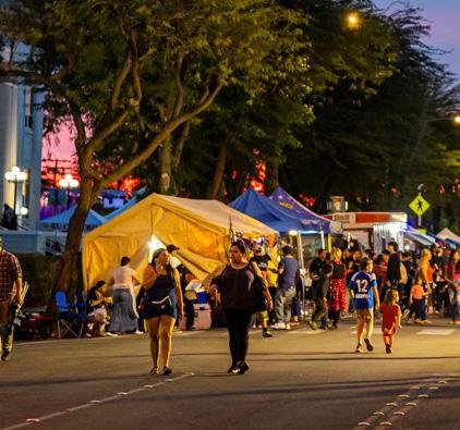
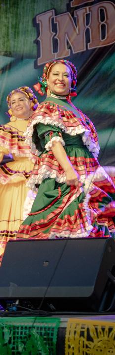
El Centro is a predominantly LatinX/Hispanic community and like many others, it lacks gathering spaces — such as along Imperial Avenue — for physical activity which often leads to increased health issues.11 Over half of neighborhoods surrounding Imperial Avenue are classified as disadvantaged communities, according to SB 535 Disadvantaged Communities data and they are often underinvested areas.12 This CSP strives to create a more comfortable and welcoming street environment for increased use by people walking and bicycling.
Economic Prosperity
A Complete Street encourages a more active lifestyle for pedestrians and bicyclists while creating a street environment that promotes safer driving. However, when improvements are made, it’s important to acknowledge the potential for displacement and gentrification. Thoughtful planning ensures that existing residents and businesses are protected and able to benefit from a Complete Street. Complete Streets are an opportunity to increase foot traffic for businesses along the corridor and result in economic growth. Elements and measures to achieve Complete Streets are often of low cost but can yield impactful results by decreasing pedestrian and vehicular collisions and activate the street environment for safer access to businesses and facilities along the corridor.13
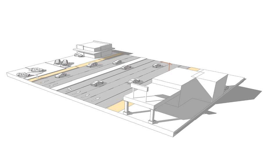
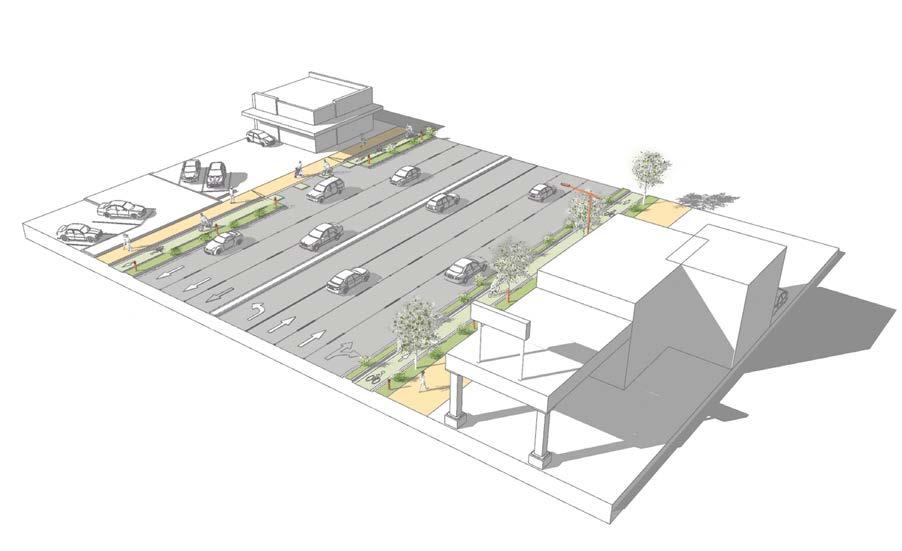
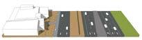
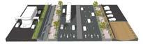
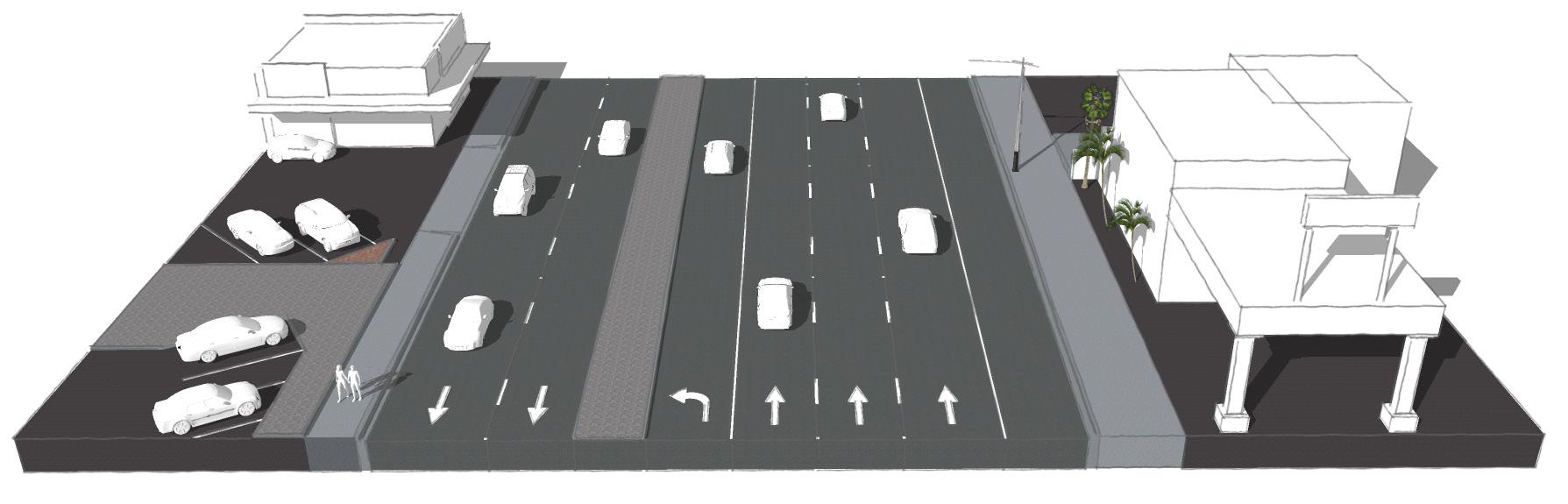
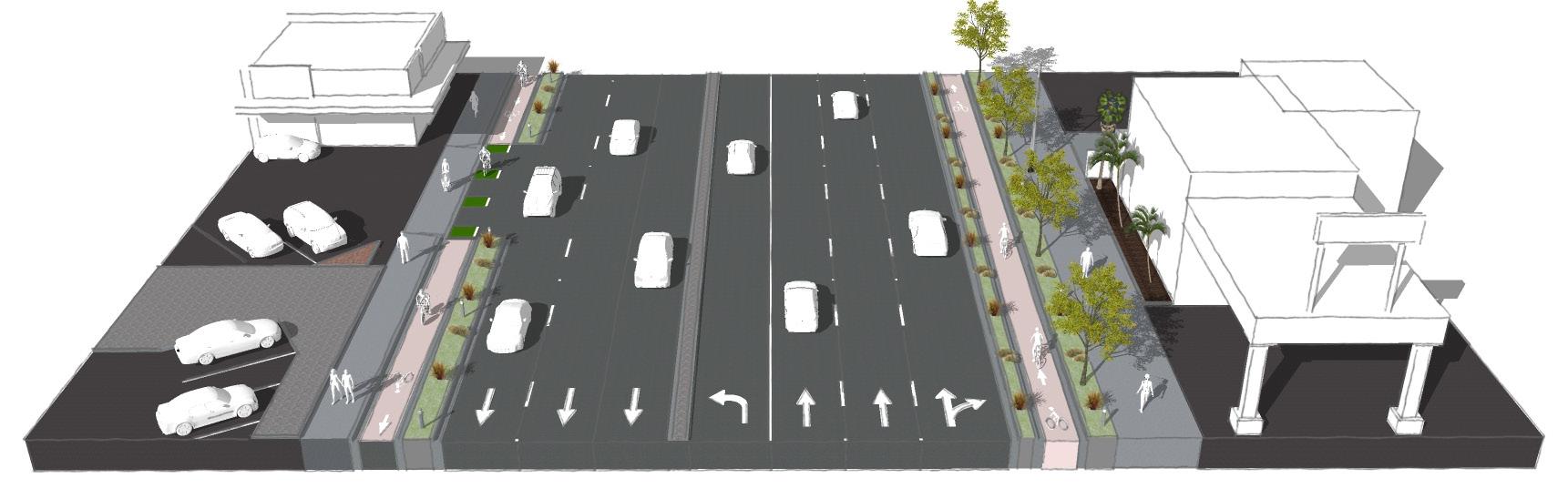
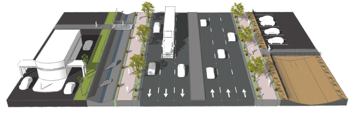
1.3 Purpose and Vision Before
The purpose of the CSP is to provide El Centro with a guide to enhance and transform the study area into a corridor that supports all modes of travel such as walking, bicycling, and taking public transit while maintaining vehicle throughput. The result will be a welcoming Complete Street for all Imperial Avenue users. The adoption of the CSP will assist El Centro to reclaim the autocentric corridor and encourage multimodal transportation that improves safety, access, and connectivity while preserving and strengthening the community character and rich history.
Endnotes
1 California Department of Transportation. (2021, December 7). Complete Streets. Caltrans. Retrieved February 6, 2024.
2 Active Transportation Alliance. (n.d.). Complete Streets, Complete Networks. Retrieved June 26, 2024.
3 Caltrans. (2024, January 16). Retrieved June 26, 2024.
4 American Planning Association. (2015). The Benefits of Street Scale Features.
5 Smart Growth America. (n.d.).
6 U.S. Department of Transportation Federal Highway Administration. (2022). Complete Streets in FHWA.
7 California Air Resources Board. (April 24, 2024). California to Propose New Greenhouse Gas Reductions from Passenger Vehicles.
8 U.S. Environmental Protection Agency. (July 8, 2024). Sources of Greenhouse Gas Emissions.
9 Pedestrian and Bicycle Information Center. (n.d.). Environment.
10 U.S. Environmental Protection Agency (2024). The State of California’s Draft Priority Climate Action Plan.
11 Salud America. (May 14, 2019). The State of Latino Housing, Transportation, and Green Space: A Research Review.
12 California Office of Environmental Health Hazard Assessment. (2022). SB 535 Disadvantaged Communities.
13 Smart Growth America. (2015). Safer Streets, Stronger Economies: Complete Streets Project outcomes from Across the Country.
Existing Conditions 2
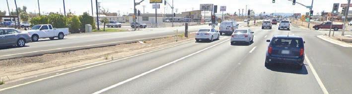
2.1 Existing Conditions
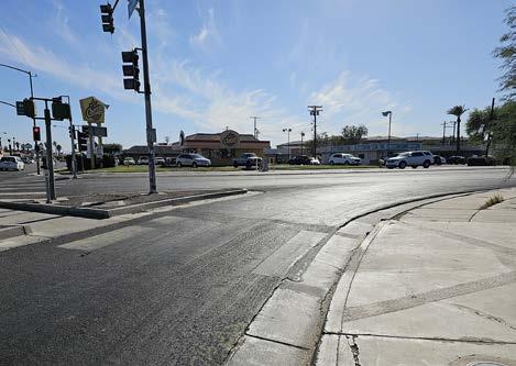
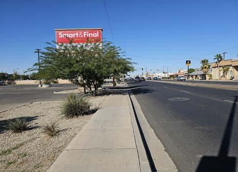
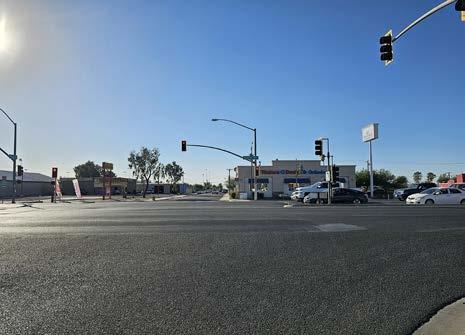
The section of Imperial Avenue between Adams Avenue and Treshill Road was constructed in the 1960s as SR 86, and therefore prioritized vehicle speed and throughput at the cost of convenience and safety of non-vehicular users. Existing conditions along this segment include lack of sidewalks, open drainage channels on both sides of the corridor, limited crossings, lack of bicycle facilities, and high driving speeds. Over the last 60 years, the area around Imperial Avenue has developed with a mix of land uses such as housing, commercial destinations, offices, and community facilities. An assessment of the barriers and opportunity areas to improve all modes of transportation is made possible through an extensive and comprehensive analysis of the existing conditions as outlined in this chapter.
2.1.1 Guiding Documents
A review of existing planning documents at the local and regional level was completed to ensure alignment between the proposed recommendations of this CSP and previous efforts. Previous planning studies provide guidance on past and current street developments as well as room for improvement for the future. The following are a list of the documents reviewed and analyzed.
The Regional Long-Range Transportation Plan (ICTC) (2024)
Imperial County Active Transportation Plan (2022)
Caltrans District 11 Active Transportation Plan (2022)
El Centro General Plan Update 2040 (2021)
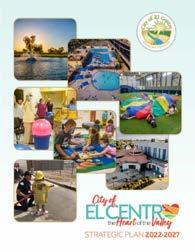
City of El Centro the Heart of the Valley Strategic Plan 2022-2027 (2021)
The City of El Centro Active Transportation & Safe Routes to School Plan (2019)
El Centro Vision 2050 Strategic Plan (2015)
Drainage Master Plan (2009)
The
Regional Long-Range Transportation Plan (2024)
The Regional Long-Range Transportation Plan addresses the future needs and growth of residents and commuters throughout Imperial County. High priority projects within the region were identified as opportunities for potential funding with support from community members who participated throughout the community outreach process. Prioritized transportation projects include the widening of Imperial Avenue from four to six lanes, installation of Class I multi-use paths in both directions from northern city limits to Adams Avenue, and pedestrian improvements, such as pedestrian countdown timers, ADA curb ramps, continental high-visibility crosswalks, and pedestrian refuge islands.
The Imperial County Transportation Commission Regional Active Transportation Plan (2022)
The Imperial County Transportation Commission Regional Active Transportation Plan identifies the City of El Centro as being one of two regional priority projects that have the potential of connecting with surrounding cities to create safer and more accessible connections. Imperial Avenue falls within one of two priority projects identified within the prioritization process of the Plan with recommendation of a Class I bicycle lane.
Caltrans District 11 Active Transportation Plan (2022)
City of El Centro the Heart of the Valley Strategic Plan (2021)
The Caltrans District 11 Active Transportation Plan is a comprehensive document identifying gaps and barriers faced by pedestrians and bicyclists. High priority locations and segments for future planning, construction, and improvements were identified in an effort to create a walkable and bikeable community. The CSP is accompanied by an interactive online map which demonstrates location-based needs for people walking or bicycling along highways. Imperial Avenue prioritized as Tier 1, representing the highest intensity of need.
El Centro General Plan Update 2040 (2021)
El Centro General Plan is a comprehensive document that includes the City’s incorporated areas and land within its sphere of influence. General Plans are required to include eight elements but for the purposes of the CSP the applicable chapters reviewed covers Land Use, Circulation, and Environmental Justice. Opportunity Area (OA-1) overlaps with one intersection of the CSP study area, at Imperial Avenue and Adams Avenue. Adams Avenue is to be planned as a four-lane arterial with Class IV cycle tracks on both sides per Policy OA-1.9 of the General Plan’s Land Use element and shows high-visibility crosswalks and conflict striping at the Imperial Avenue intersection. The Circulation Element samples pedestrian and bicycle treatments to use within the opportunity areas and throughout the City. These treatments as well as relevant policies from the General Plan were applied to this CSP, as found in Chapter 4.
The City of El Centro the Heart of the Valley Strategic Plan creates a roadmap for the planning period of 2022-2027 and it is meant to include goals and objectives of the Vision 2050 Plan which still serves as a guiding document for the City. The short planning period of this plan is meant to address the more immediate goals and actions for the pursuit of funding.
The City of El Centro Active Transportation & Safe Routes to School Plan (SRTS) (2019)
This plan presents recommendations and programs to promote more bicycling and walking throughout the City with the objective of improving non-motorized transportation, promoting public health, and promoting transportation equity. Identified recommendations for schools within proximity of the Imperial Avenue study area are Lincoln Elementary, McKinley Elementary School, Kennedy Middle School and Martin Luther King Elementary School. A recommendation applicable to Imperial Avenue identified for Lincoln Elementary school is the installation of buffered bicycle lanes, separated bikeways, and bicycle lanes along corridors such as Adams Avenue and Imperial Avenue. Additionally, the removal of the free-right turn located on the intersection of Imperial Avenue and Adams Avenue is proposed within this plan.
El Centro Vision 2050 Strategic Plan (2015)
The El Centro Vision 2050 Strategic Plan identifies goals and objectives to help guide the pursuit of creating a prosperous future for the City. Five vision elements within the document to help achieve the vision of the City of El Centro by 2050 are:
Safety and Community Preservation
Quality of Life Amenities
Economic Development
Development and Mobility
Community Pride and Spirit
City of El Centro Master Plan of Drainage (2009)
VISI N 2050
Relevant strategies to the Imperial Avenue study area include the improvement of thoroughfare by the incorporation of landscaping and lighting for pedestrians, the relocation of utilities for improved visual quality, and the enhancement of crossings for connectivity and safety.
The City of El Centro Master Plan of Drainage outlines design criteria and identifies drainage deficiencies in addition to recommendations for drainage improvements. Imperial Avenue’s existing drainage facilities are owned and operated by Caltrans and require careful consideration to provide a safe environment to prevent flooding during wet seasons. The existing drainage facilities flow into Imperial Irrigation District (IDD) Facilities which are owned and operated by the City of El Centro. A proposed solution is the upsizing of the existing system and the addition of catch basins. Imperial Avenue from Scott Avenue to the railroad track is identified as needing an upgrade to the existing storm drain and additional catch basins. The same upgrades were recommended west of Imperial Avenue along the Northgate Shopping Center and east of the corridor along the Town Center shopping Center. From Villa Avenue to Imperial Avenue to Scott Avenue flooding occurs along the street and this plan recommends that the existing storm drain is extended.
Upon future planned relinquishment of the Imperial Avenue drainage facilities from Caltrans to El Centro, the City will be responsible for any future studies, maintenance, and planned improvements.
2.2 Community Demographics
44,184 Under 19 years
Black or African American American Indian & Alaska Native
Native Hawaiian & Other Pacific Islander Some other race Two or more races Hispanic or Latino (of any race)
Hispanic or Latino
Source: U.S. Census Bureau. (2022). American Community Survey, ACS 5-Year Estimates Subject Tables DP05, S0101, S0801, S2405.
2.3 Land Use
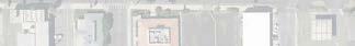
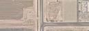
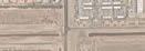
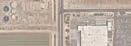
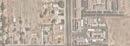
El Centro prioritizes maintaining a balanced and diverse mix of land uses all of which are necessary for maintaining a healthy community. The City is comprised of mostly Low Density Residential land use but with a mix of General Commercial, General Industrial, Light Industrial, and Public Use, as shown in Figure 2-1.
Land use along Imperial Avenue consists of mainly General Commercial and Heavy Commercial use. Other uses facing the corridor are Low Density Residential Use, Mixed Use 1, Tourist Commercial Use, Neighborhood Commercial Use, and Public Use. Adjacent uses to Imperial Avenue include High-Medium Density Residential Use. A small portion at the intersection of Imperial Avenue and Adams Avenue also falls within the Adams Avenue Opportunity Area (OA-1).
Study Area Land Use Descriptions
Low Density Residential Use
Development in this category is characterized by single-family detached dwelling units, ADUs, and accessory buildings.
Mixed Use 1
Development in this category is characterized by multiple-family residential, live/work, and retail and service-oriented uses serving the needs of local neighborhoods; allowing mixed use, stand-alone residential, standalone commercial developments.
General Commercial
Development in this category is characterized by Retail, light service, and general business, as well as large-scale planned shopping districts serving the local and regional area; where appropriate, motel/hotel & public assembly uses.
Heavy Commercial Use
“Wow, Imperial Avenue has a diverse range of land use!”
Development in this category is characterized by general commercial uses, business and consumer services, and light manufacturing.
Tourist Commercial Use
Development in this category is characterized by motels, resort hotels, related commercial and tourist oriented uses, retail and freeway oriented uses; multiple-family residential may be permitted.
Neighborhood Commercial Use
Development in this category is characterized by retail and service-oriented uses serving the needs of local neighborhoods.
Public Use
Development in this category is characterized by parcels owned by the City of El Centro, Imperial Irrigation District, school districts, or El Centro Regional Medical Center containing police and fire departments, libraries, sewer facilities, flood control basins, parks and recreation facilities, cemeteries, museums, etc.
2.3.1
Community Destinations
Attractions
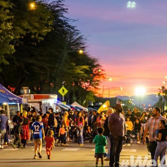
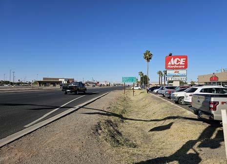
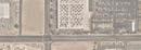
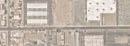
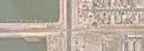
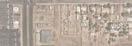
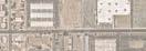
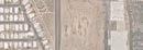
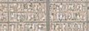
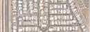
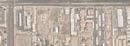
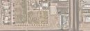
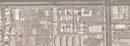
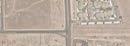
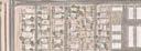
The portion of Imperial Avenue within the study area provides access to commercial areas, two parks, Carlos Aguilar Park and First Responders Park, grocery stores, vacant lots with planned commercial development, and residential areas ranging from mobile home parks to single family homes. The nearest schools are about a half-mile away from the corridor. Future developments on Imperial Avenue include an array of commercial uses ranging from cafes, eateries, medical centers and offices, and a gas station.
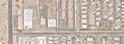
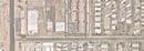
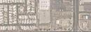
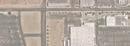
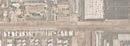
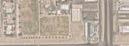
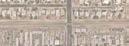
Capital Improvement Projects (CIP) along Imperial Avenue include the Valley Centerpoint Demolition near the northwest corner of Imperial Avenue and Scott Avenue. Because of the desert climate, residents have year-round extreme heat days which make for an uncomfortable walk, ride a bike, or wait for public transit to and from popular and everyday destinations. Understanding the most traveled areas, as shown in Figure 2-2, helps guide the recommendations of the CSP to make modes of transportation not only more safe, but also more comfortable and accessible to and from attractions.
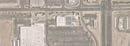
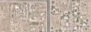
Figure 2-2: Land Use and Community Destinations/Attractions
2.4 Walk Audit
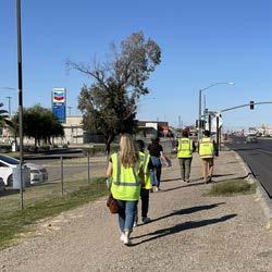
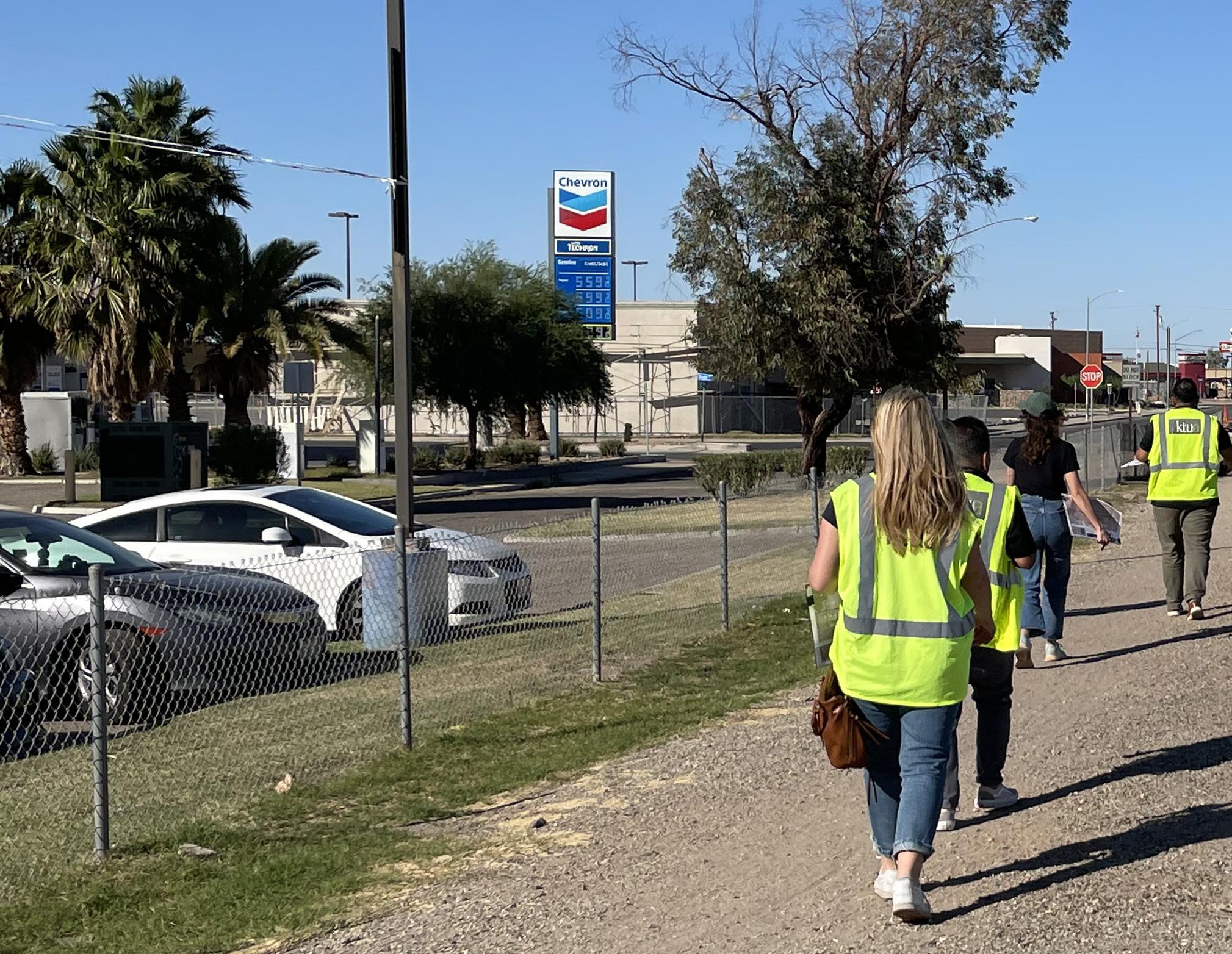
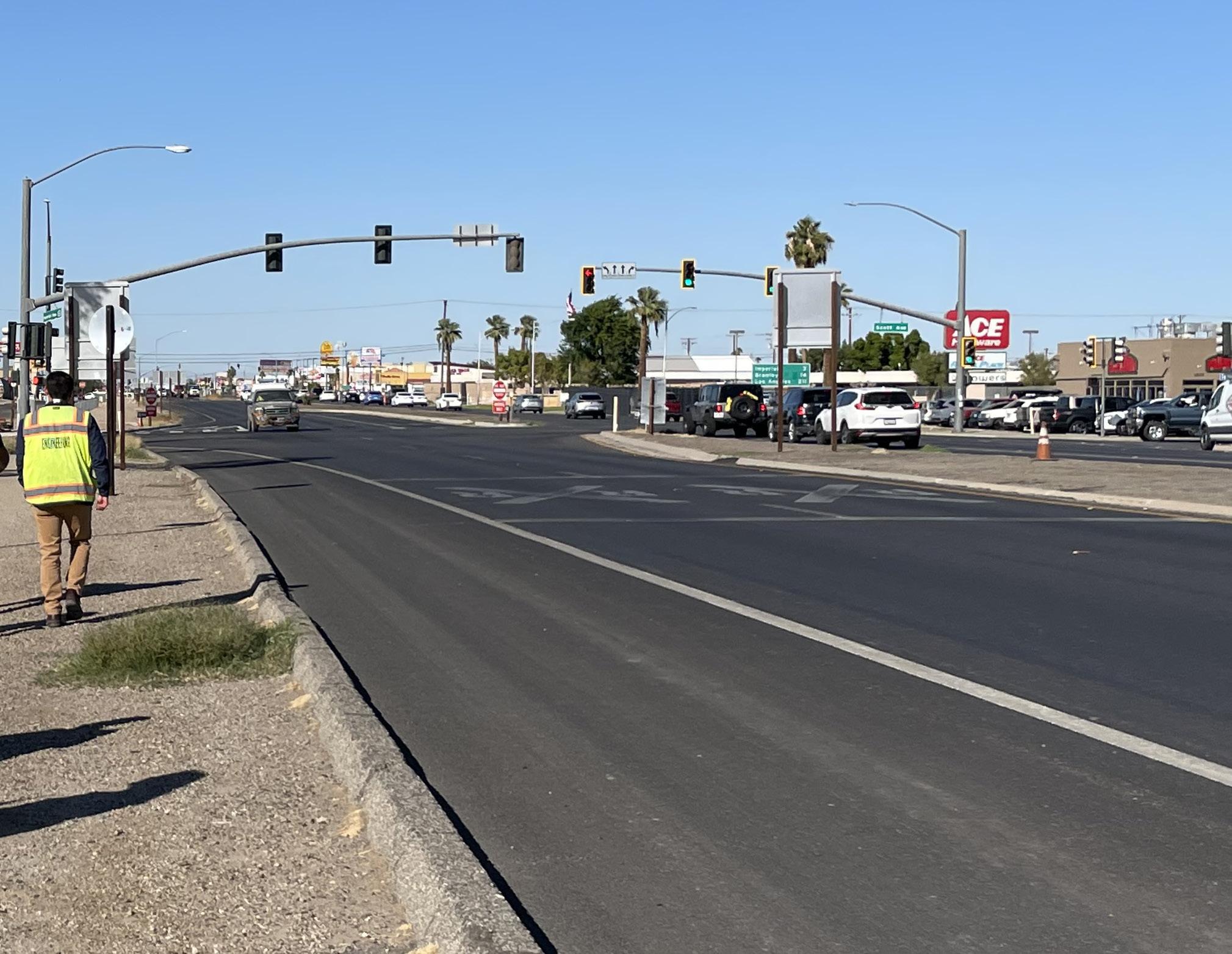
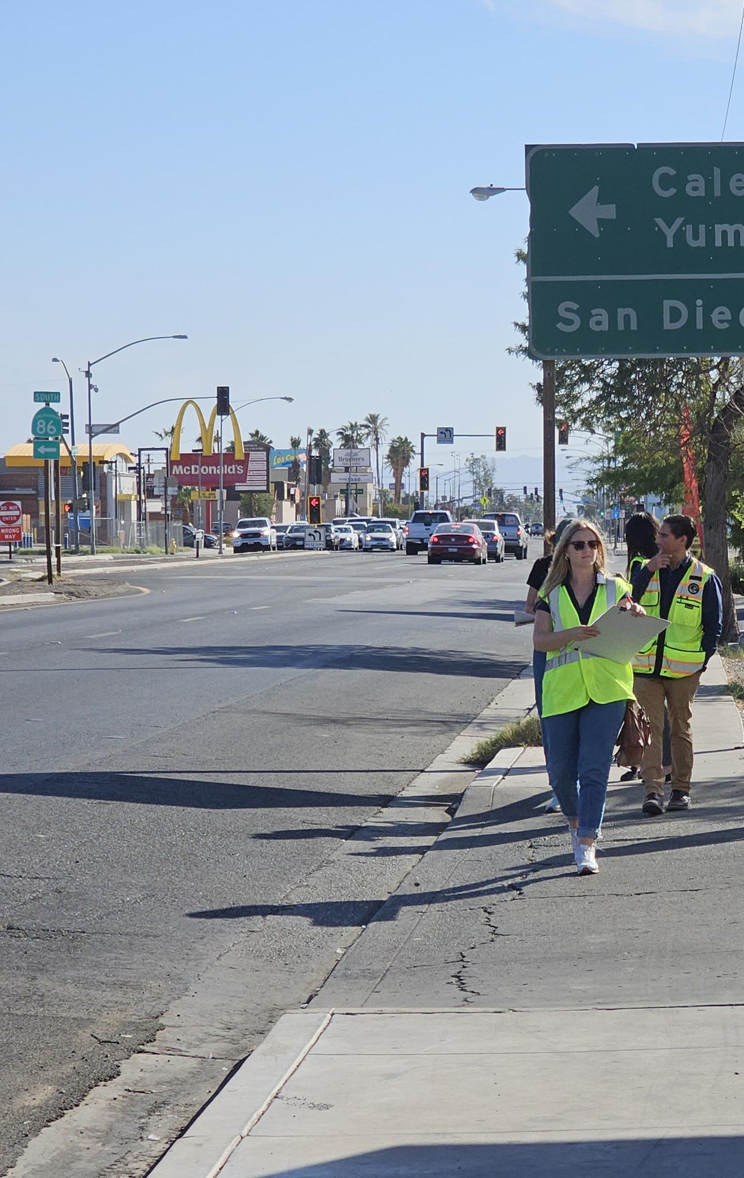
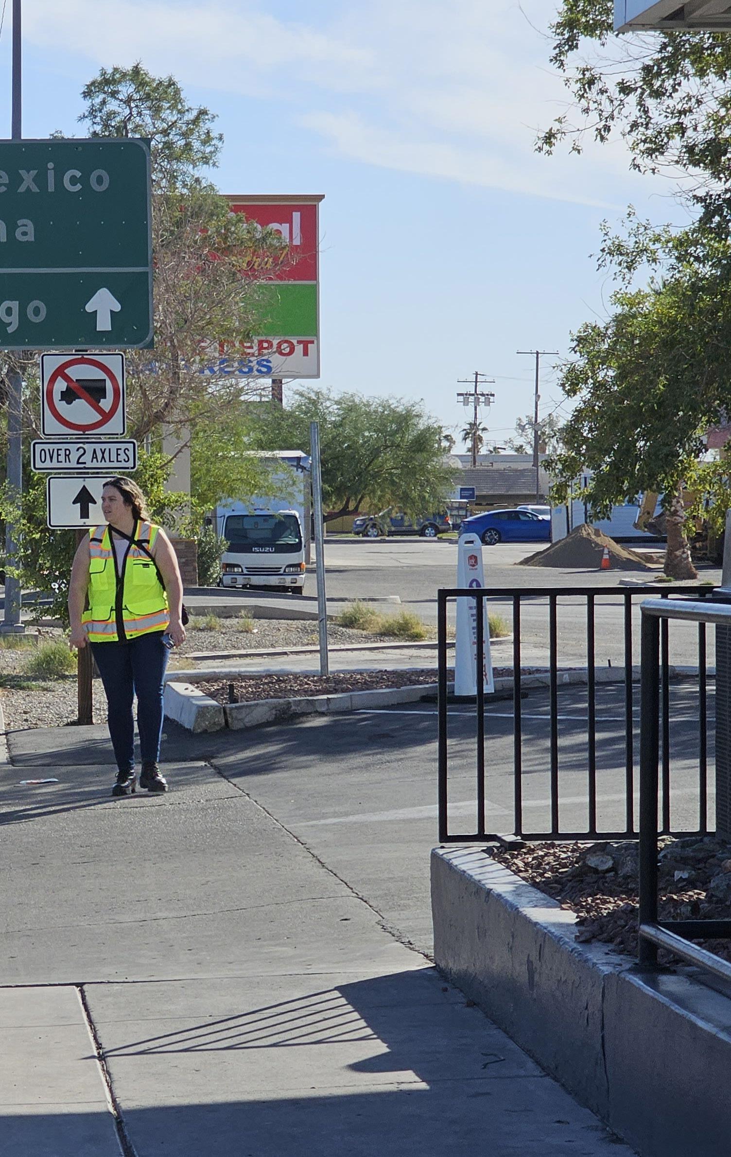
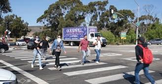
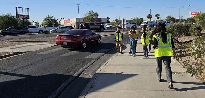
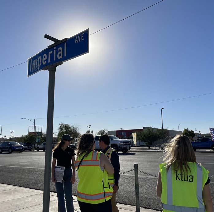
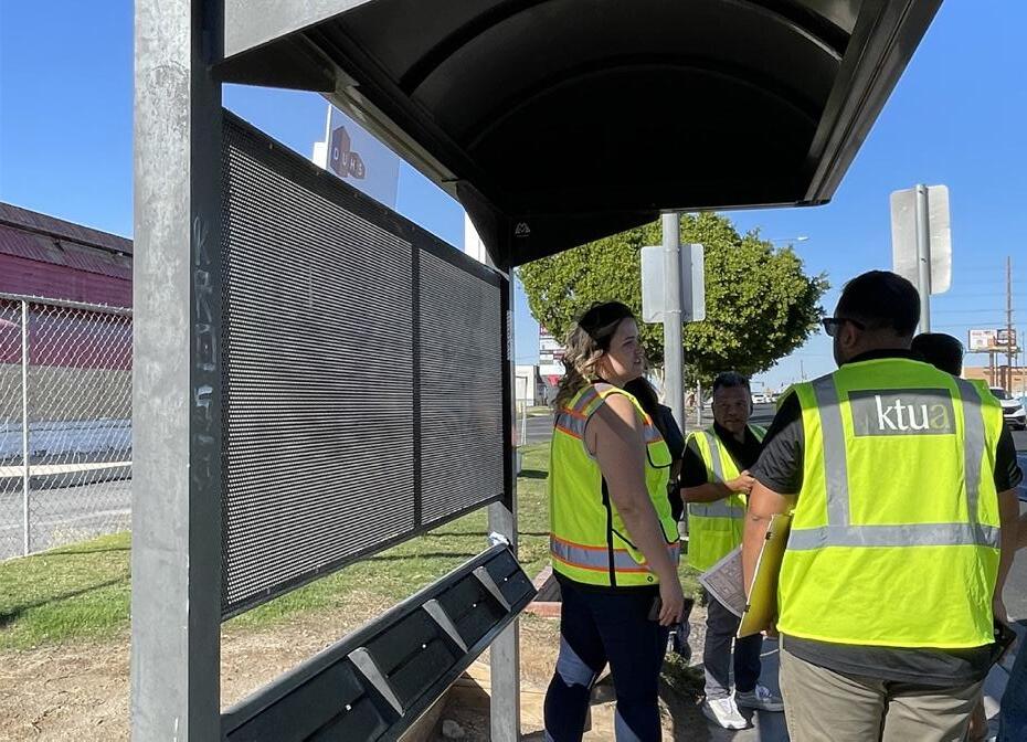
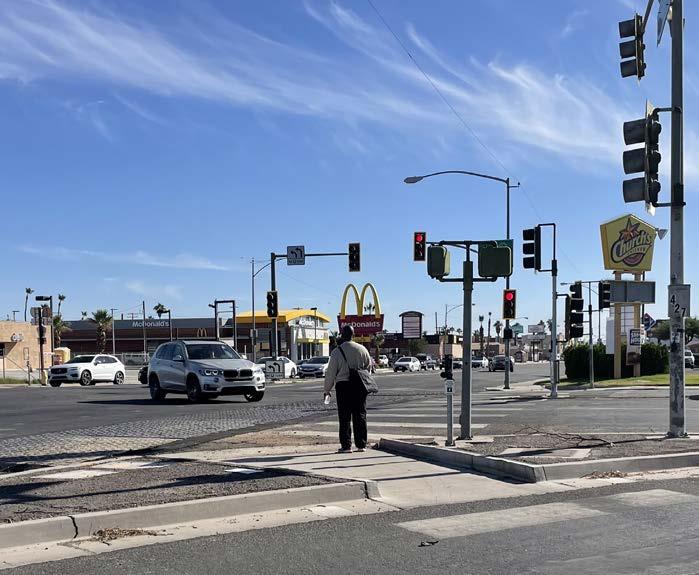
Walk audits are an integral part of the CSP. They offered the opportunity for the Project Team to walk in the shoes of residents to better understand and assess the existing conditions, needs, and barriers.
Walk Audits (November 8, 2023 )
During the initial walk audit on November 8, 2023, the Project Team and El Centro City staff walked along Imperial Avenue. They documented areas of interest on a site map, supported by photographs, and noted the following observations along the corridor:
Drainage constraints
Changes in topography along different stretches of the corridor
Missing curb ramps and truncated domes at some crossing points
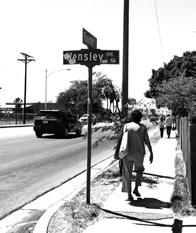
Missing sidewalks
Lack of shelter
Long distances for pedestrian crossings
Speeding cars (varied posted 35 to 55 miles per hour speed limit along the segments)
lanes pose pedestrian conflict areas
No pedestrian access at railroad crossing
Frontage roads
2.5 Transportation Characteristics
2.5.1 Transit Routes and Stops
Public transportation for El Centro is available to residents through a fixed public bus service by Imperial Valley Transit (IVT), servicing Imperial County since 1989. Bus services provided by IVT include fixed routes, deviated fixed routes, and remote zone routes. Lines 2, 3, and the Green Line run along Imperial Avenue:
2N - El Centro to Niland
2S - Niland to El Centro
3E - El Centro to Holtville
3W - Holtville to El Centro
Green Line
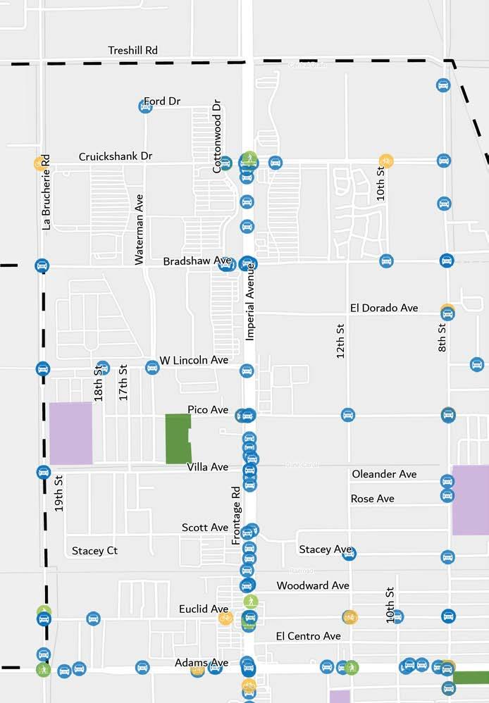
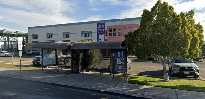
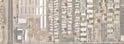
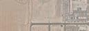
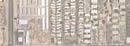
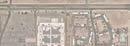
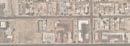
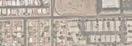
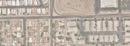
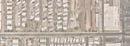
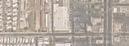
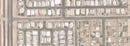
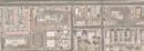
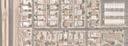
Some transit stops along the corridor have bus shelters with seating and others only display signage. Bus stops along and near the corridor are shown in Figure 2-3.
Figure 2-3: Bus Stops on Imperial Avenue
City Boundary Study Area Boundary
Schools
Parks Bus Stops
Martin Luther King Elementary N
McKinley Elementary
Carlos Aguilar Park
Adams Park
2.5.2 Commuting Mode Share
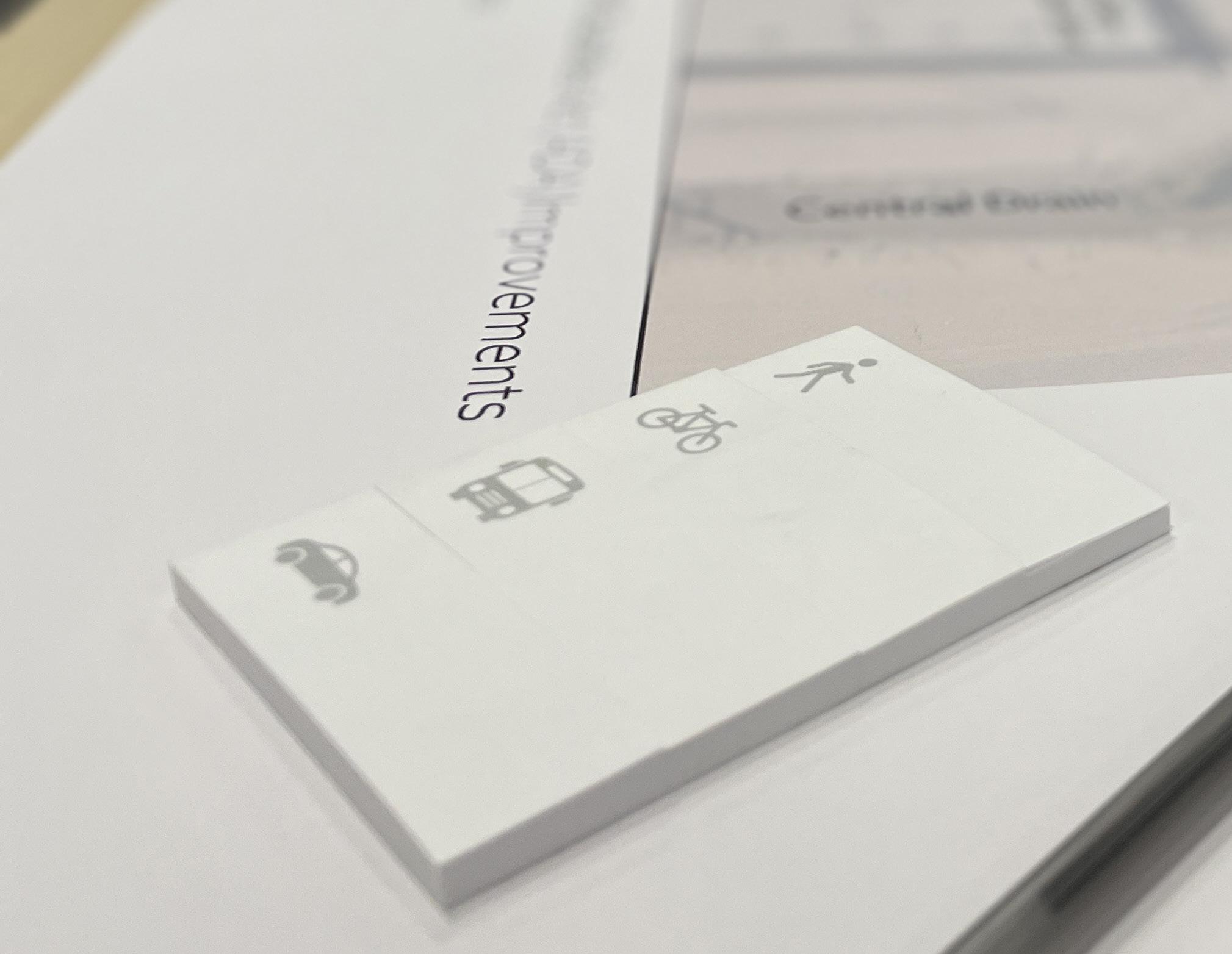
As a major north-south connection, Imperial Avenue is heavily used for daily commuting within the City and surrounding areas. Table 2-1 depicts the estimated travel modes utilized by people 16 years and over who work in El Centro according to the U.S. Census 2022 American Community Survey 5-Year Estimates (ACS).1 The majority of people working travel alone by automobile followed by people carpooling and have an average travel time of 21.6 minutes to their destination. Active modes of transportation are below two percent, demonstrating the need for Complete Streets improvements such as sidewalks, bicycle lanes, and shade.
Bicycling Mode Share
Similar to the walking mode share, bicycling mode share measures the percentage of resident workers aged 16 years and over who commute to work by bicycle. Throughout El Centro, there is no reported bicycle use when commuting to work according to the ACS data. However, this does not mean there is no need or interest in commuting by bicycle within the city.
Public Transit Mode Share
Transit mode share measures the percentage of workers aged 16 years and over who commute to work by transit. This mode share reflects how well the mobility infrastructure, transit routes, and land-use patterns support travel to work by transit.
Walking Mode Share
The walking mode share measures the percentage of workers aged 16 years and over who commute to work by foot and it reflects how well infrastructure and land use patterns support travel to work by foot. In the city, walking mode share patterns are connected to the relative proximity of housing to employment centers.
Table 2-1: Commute to Work Travel Modes
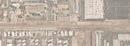
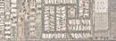
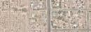
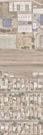
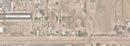
2.5.4 Sidewalk Network Evaluation
Complete Street improvements encourage pedestrians to walk more as they make streets more appealing to pedestrians due to increased safety and walkability. Identifying deficiencies in the pedestrian network is critical using data provided by El Centro. Figure 2-4 shows missing sidewalks along large portions of Imperial Avenue on both sides of the corridor. Missing sidewalks are concentrated on the northern portion of Imperial Avenue. Frontage roads on the west side of the corridor have existing sidewalks and create access to commercial uses and public facilities. However, the lack of sidewalks on both sides of the corridor create a disconnection across destinations.
Figure 2-4: Missing Sidewalks on Imperial Avenue
City Boundary Study Area Boundary Schools Parks Bus Stops Missing Sidewalks
N
Martin Luther King Elementary
Adams Park
El Centro Library
McKinley Elementary
Data Source: City of El Centro Community Development Department
Carlos Aguilar Park
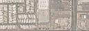
2.5.3 Bicycle Facilities
In the development of this CSP, the existing and planned bicycle facilities were analyzed to align to the greatest extent possible recommendations with past and future planning efforts.
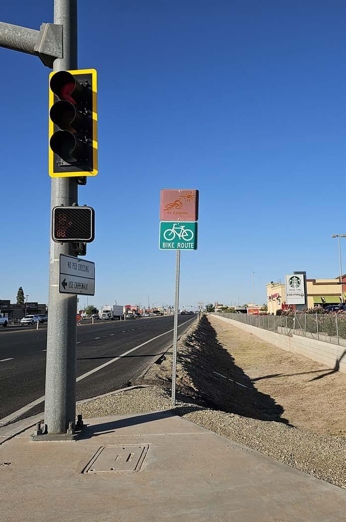
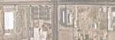
Existing Bicycle Facilities
Imperial Avenue existing bicycle facilities as shown in Figure 2-5, consist of Class III along the majority of the corridor. Intersecting bicycle facilities for east-to-west connections include Class II, Class III, and some Class I.
Planned Bicycle Facilities
According to El Centro’s General Plan Circulation Element, Figure 2-6, shows the planned expansion of bicycle facilities along Imperial Avenue include upgrading from the existing Class III bike routes to Class IV cycle tracks with intersecting Class I, Class II, and Class III bike facilities. Additionally, the Project Team during walk audits and traffic counts recorded bicycle ridership, observing the need for facilities to protect existing and attract new riders.
City Boundary
Study Area Boundary
Schools
Parks
Class I - Multi Use Path
Class II - Bicycle Lanes
Class III - Bicycle Routes
N
Martin Luther King Elementary
Adams Park
McKinley Elementary
Data Source: Southern California Association of Governments (SCAG)
Figure 2-5: Existing Bicycle Facilities
Carlos Aguilar Park
Figure 2-6: Proposed Bicycle Facilities from 2021 General Plan
City Boundary
Study Area Boundary
Schools
Parks
Class I - Multi Use Path
Class II - Bicycle Lanes
Class III - Bicycle Routes
Class IV - Separated
Bikeways
Martin Luther King Elementary
Adams Park
McKinley Elementary
Data Source: El Centro General Plan 2021 (Mobility Element)
Carlos Aguilar Park
Bicycle & Pedestrian Crash/Collisions Analysis
A comprehensive crash analysis was conducted using Statewide Integrated Traffic Records System (SWITRS) data to track bicycle, pedestrian, and vehicle collisions along Imperial Avenue. Figure 2-7 depicts six of the intersections with a high number of crashes, ranging by collision type - pedestrian, bicycle, or vehicle collision.
Traffic Count Analysis
Traffic counts were conducted on October 24, 2023 at AM and PM peak times for cars, pedestrians, and bicyclists to understand how people are currently using and moving through the study area. Despite the lack of pedestrian and bicycle amenities, users were recorded using these modes. Pedestrian and bicycle counts were higher in the southern portion of the corridor, Segment A, likely due to the presence of existing sidewalks for protection.
Refer to Appendix A.2 for detailed Existing Lane Geometry and Existing AM/PM Hour Volume exhibits.
2-7: Pedestrian, Bicycle, and Automobile Collisions
City Boundary
Study Area Boundary
Schools
Parks
Pedestrian Collision
Bicycle Collision
Vehicle Collision
1 United States Census Bureau. (2022). S0801 Commuting Characteristics.
Data Source: SWITRS
N
Martin Luther King Elementary
Adams Park
El Centro Library
McKinley Elementary
Figure
Carlos Aguilar Park
Public Engagement 3
3.1 Outreach Strategy Overview
Input from the public provided the CSP planning process with valuable information while strengthening trust and support of the project. Community members have firsthand experience with the strengths and areas needing improvement on Imperial Avenue and public outreach is a key component of project recommendations.
The outreach strategy consisted of the following events and all materials were provided in English and Spanish throughout the engagement process:
A project website
E-newsletters and social media posts
Postcards to businesses on Imperial Avenue
An online and paper survey for field interviews/intercept surveys along Imperial Avenue
A Geographical Information System (GIS) based interactive online map survey
Three (3) community workshops
Four (4) project advisory committee (PAC) meetings
Four (4) pop-up events
3.1.1 Project Branding
To engage, inform, and educate the public, project branding was established to provide digestible informative material for the community. El Centro does not have adopted design guidelines and it allowed for the development of a logo, color palette, typography, and infographics that were representative of Imperial Avenue.
3.1.2 Project Website
A project website was generated to be a bank of information as the CSP was developed with the inclusion of the project description, project timeline, project milestones, and public engagement opportunities such as the GIS-based interactive online mapping survey which allowed the public to drop icons representing a topic with a comment of any area of concern along Imperial Avenue.
#196775
#ed6129
#f09723
3.1.3 Newsletters & Social Media
Bilingual e-newsletters were sent to the project database at key milestones. The database grew throughout the project due to participation in the survey and sign-ups at the various public engagement events. E-newsletters were sent to over 500 community members.
Articles were also used as a way to engage the community as articles were drafted by the Project Team and City Staff and were posted on El Centro’s Community Newsletter for the Summer of 2023 and 2024.
Additionally, social media posts were made on the City’s social media platforms throughout all stages of the CSP.
3.1.4 Postcards
A bilingual postcard was mailed to El Centro businesses along Imperial Avenue to inform business owners and operators of the CSP to obtain additional information through the project website prior to Workshop #3 held on November 14, 2024. El Centro staff provided a list of 169 active businesses, and the postcard were mailed to all on October 21, 2024, with an arrival date and in mailboxes by October 25, 2024.
3.2 Surveys
To better understand the challenges, barriers, and opportunities for Imperial Avenue, the Project Team developed a GIS-based interactive online mapping survey and conducted intercept surveys with a traditional community survey.
The traditional survey was made available online through a Quick Response (QR) Code and website link as well as a physical survey distributed during public engagement events. The survey material was made available from October of 2023 to January of 2024.The survey was promoted on the City’s various social media platforms, at city events, and a large banner displayed at Carlos Aguilar Park. Opportunity drawings were also provided by the City to incentivize survey participation.
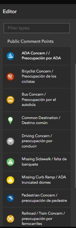
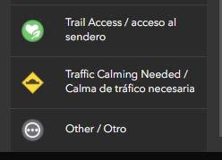
3.2.1 GIS Interactive Survey
A GIS interactive survey was posted at the start of the project along with the project website where a range of comment points/categories were available for participants to note areas of concern. The option to include any other concern or comment was also made available.
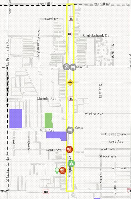
Concerns noted on the interactive survey included:
Driving concerns on Bradshaw Avenue and Villa Avenue where intersecting with Imperial Avenue
Traffic calming needed on El Dorado Avenue and Imperial Avenue intersection
Bicycle concerns on Scott Avenue and Imperial Avenue intersection and parking lots
Missing sidewalks approaching the railroad
Grocery store (Vons) as a common destination
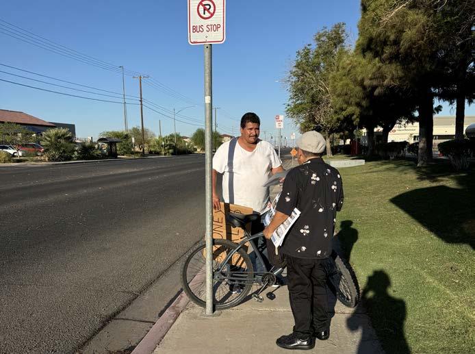
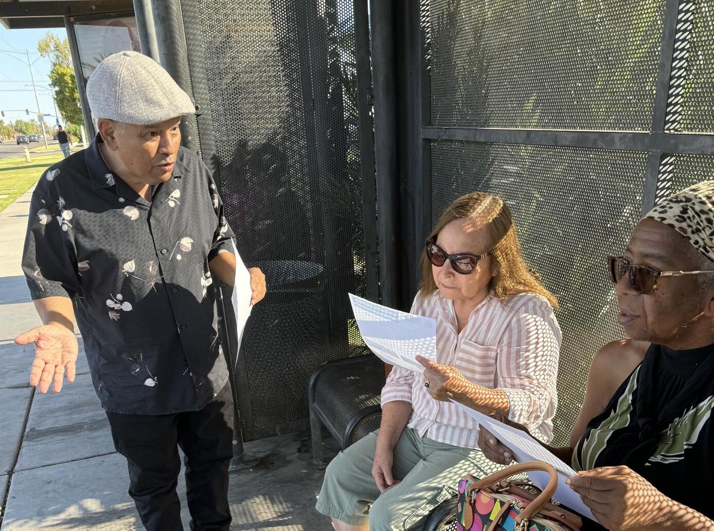
3.2.2 Intercept Surveys
Although most people have access to the technology required to complete the digital survey, it was important to ensure the survey was accessible to everyone, including those without the necessary technology or those who may experience discomfort with digital tools. For this reason, the Project Team also offered a physical survey option and conducted field interviews/intercept surveys.
Intercept Survey #1 (December 13, 2023)
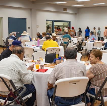
On December 13, 2023, with permission from the El Centro School District, the Project Team visited McKinley Elementary and Kennedy Middle School during after-school pickup to conduct CSP surveys to parents and caregivers. Those waiting to pick-up their students were happy to participate in the survey, and Kennedy Principal Richard Sanchez offered extra credit to the students whose parents participated. Additionally, the Project Team visited the library as well as transit stops near Costco and the Department of Motor Vehicles (DMV). Overall, participants were enthusiastic about the project to improve the nearby neighborhood.
Intercept Surveys September 17 & 18, 2024
On September 17, 2024, the Project Team visited Lincoln Elementary and Martin Luther King Elementary Schools during after-school pickup to speak with parents about the project, sharing information about the second survey from Workshop #2 about the draft concept recommendations. A station was set-up outside Cardenas, with permission from the store manager.
Additionally, to reach transit users, the team visited four transit stops along the corridor on September 18, one outside Costco, and three further south. The team also stopped at the library to speak with patrons about the project and encourage survey participation.
Over the two days, residents responded positively to the improvements, with many sharing stories of near collisions along Imperial Avenue. Some expressed concern about the addition of three stoplights from their perspective as drivers. Those who used the library were especially enthusiastic about a new traffic signal allowing easier pedestrian access to the library.
448 Total Surveys
3.2.3 Survey Results Key Findings and Takeaways
Key findings and takeaways from participants who completed the online and physical surveys at CSP events or during fieldwork have been summarized. The complete survey results can be found in the Appendix A.3.
Relationship of survey participants with El Centro
79.9%
Residents
Most popular mode of travel on Imperial Avenue
94.1%
Driving
Frequency of survey participants using the following modes of travel along Imperial Avenue
Major attractions/what draws survey participants to Imperial Avenue
Concerned about enhancing safety for the following modes of travel
Top concerns about walking, bicycling, and the use of transit along Imperial Avenue
Top things that would make people walk/ride, bike, and use transit along Imperial Avenue
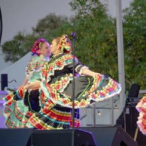
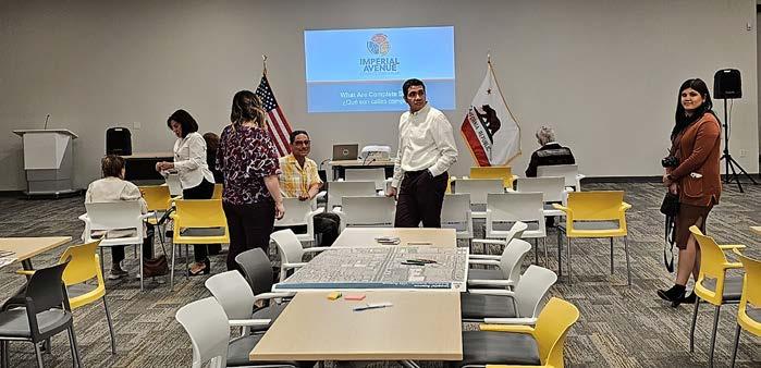
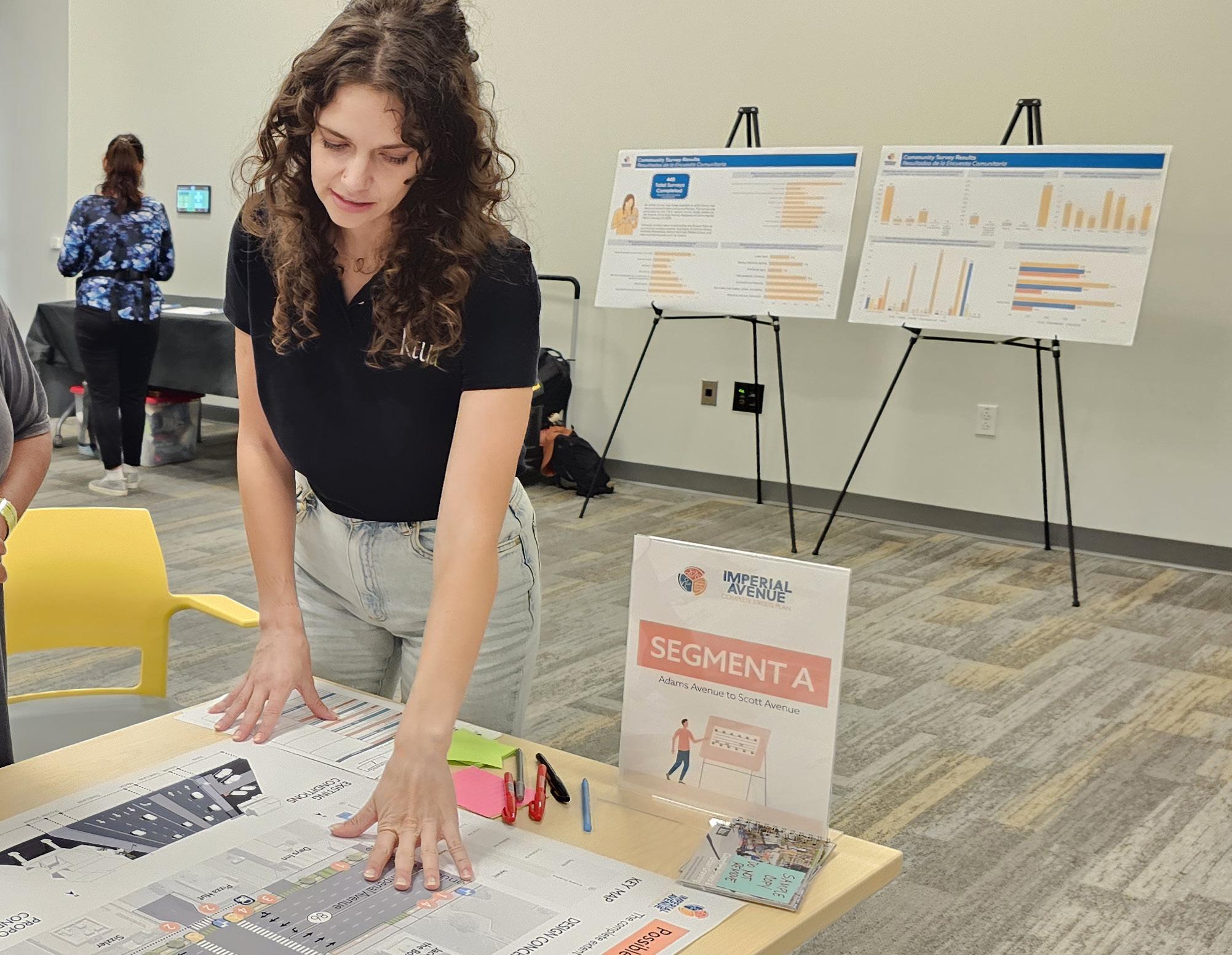
3.3 Community Workshops
Three interactive community workshops were conducted throughout various dates during the CSP planning process. All workshops were family-friendly events with bilingual staff available to facilitate participation and capture valuable feedback. The purpose of the community workshops was to identify what community members enjoy and would like to see improved on Imperial Avenue to help highlight priority areas in the advancement of the project vision of creating a vibrant corridor that connects all people to the City of El Centro.
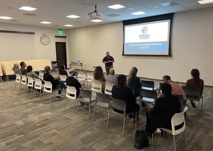
Workshop #1 - City Library (November 8, 2023)
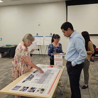
The team conducted the first community workshop on Wednesday, November 8 at the City Library located at the intersection of Villa Avenue and Imperial Avenue. A brief presentation was given by the Project Team and City Staff to introduce the CSP project. Later residents had the opportunity to review and comment on various exhibits provided which included input boards and maps to help gather comments. The feedback the team collected on existing concerns, opportunity areas, and overarching wishes for Imperial Avenue was used to develop design alternatives for residents to review at future community workshops.
developingTheCityofElCentroisaCompleteStreets completePlanthatwillassessopportunitiesfor streetimprovementsforImperial Avenue.ThePlanwillserveasaguidetohelp implementasafeandcomfortableexperience that
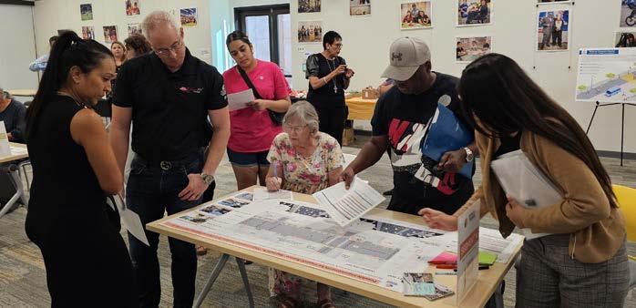
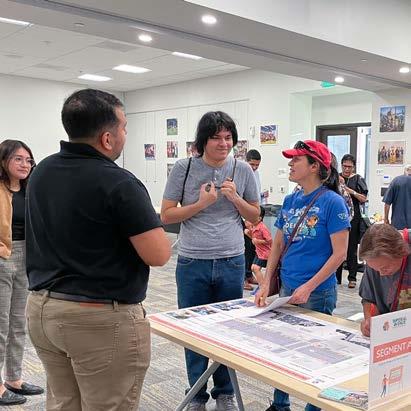
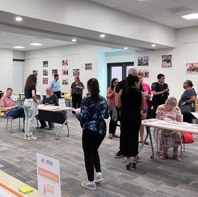
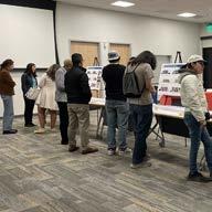
Similarly to the first workshop, the second workshop took place on Friday, August 8 at the City Library. The workshop was an open house style format where community members were encouraged to walk around and learn, comment, and participate in the various activities available.
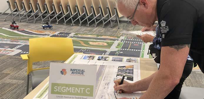
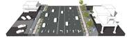
A complete streets remote control car course served as an interactive and educational activity that demonstrated traffic calming treatments to help guide pedestrians and bicyclists safely and comfortably as well as incentivize drivers to be more mindful of their surroundings to encourage safer driving. A display of boards provided a synopsis of the survey results which guided the draft recommendations that were the main focus of the workshop. The draft recommendations were shown to the public in a comprehensive but digestible format as the Imperial Avenue corridor was broken down into small portions of Segment A, B, and C. Existing and proposed three-dimensional sections of the corresponding segment accompanied the site plans and community members were asked to complete a report card for each of the segments to help gauge where further improvements were desired. Additionally, a board displaying the three locations for new proposed traffic signals was also provided for comments.
Overall, participants expressed satisfaction with the draft recommendations for all segments and previous comments made about the need for more shade, shelter, lighting, and safety for pedestrians and bicyclists still were primary areas of concern.
Draft Recommendation Survey
Following this workshop, a second survey was made available to the public for all whom were unable to attend to provide their feedback on the draft recommendations and a total of 71 surveys were completed. Overall, people were supportive of the presented recommendations for all segments and the new proposed traffic signal at the intersection of Imperial Avenue and Villa Avenue. Complete results can be found in Appendix A.4.
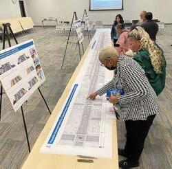
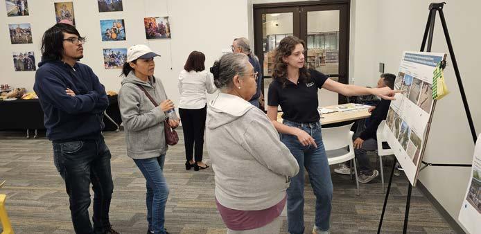
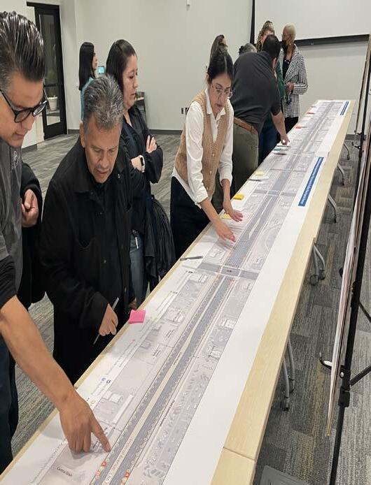
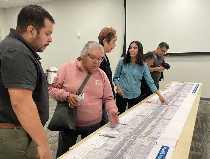
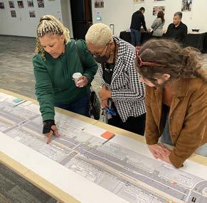
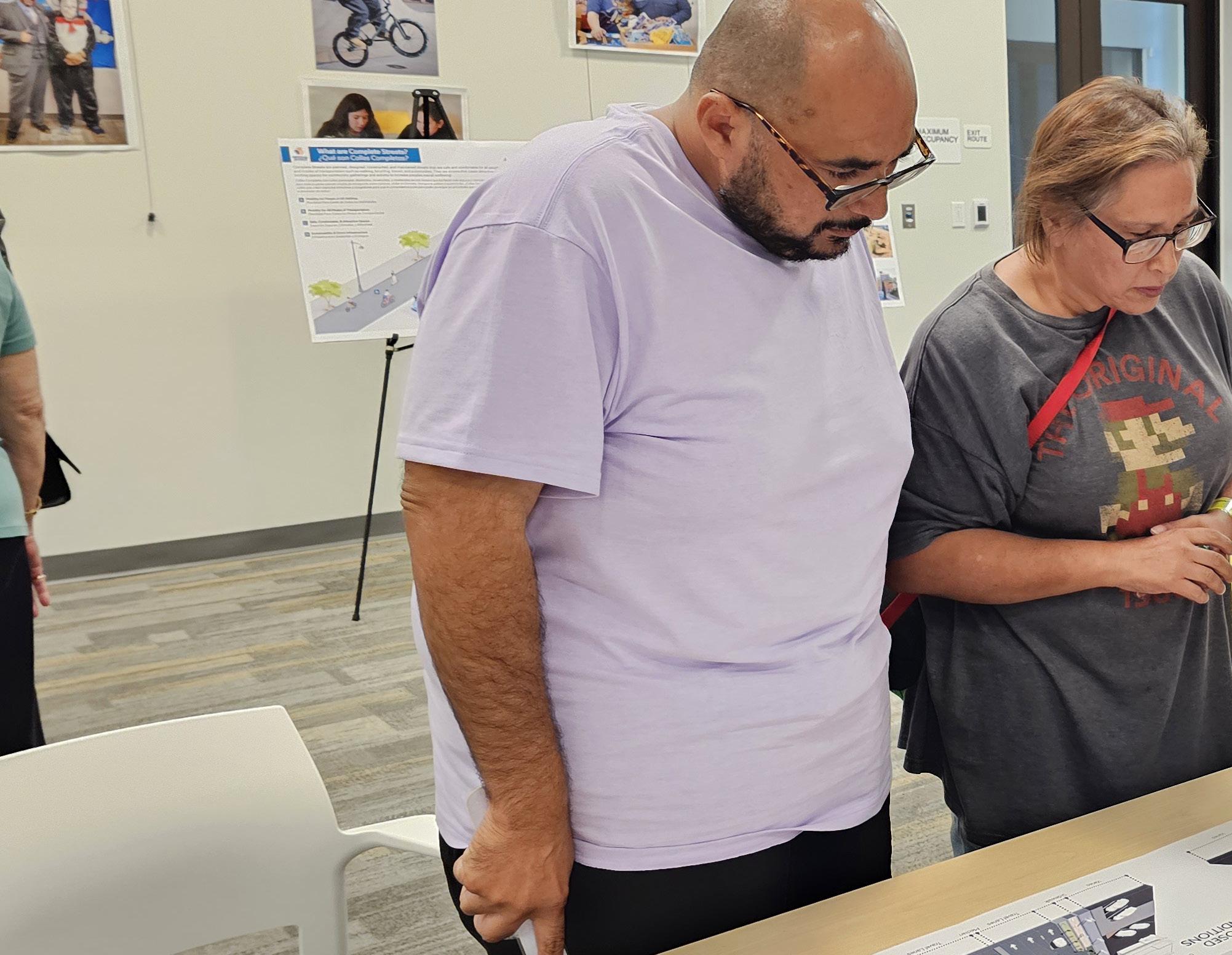
Workshop #3 - City Library (November 14, 2024)
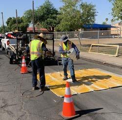
The third and last workshop was an open house style event held on November, 14, 2024 at the City Library. The workshop began with a presentation that revisited each stage of the project from the existing conditions analysis and community engagement through preliminary concept design. After the presentation, the remainder of the workshop was treated as an open house, where participants assessed the draft concept design for the entire corridor, printed at nearly 20’ in length and 14” in height. The enlarged printout, paired with a legend and photos of treatments, allowed community members to more easily understand the recommendations proposed. Attendees took their time reviewing the concept and shared their feedback in writing. Common themes involved increasing pedestrian and bicycle access to businesses, adding clear zones along frontage roads, and adding enhanced pedestrian amenities at the railroad crossing.
3.4 Project Advisory Committee (PAC)
A project advisory committee (PAC) was formed to be an advisory body and provide ongoing feedback throughout the project. Four PAC meetings were held throughout the planning process and all were held virtually to accommodate members’ schedules. Representatives from stakeholder organizations, community representatives, and City Staff who experience Imperial Avenue on a regular basis participated. A summary of each meeting is described below.
Participating organizations included:
Caltrans
El Centro Elementary School District
Imperial County Transportation Commission
Lotus Living
Mayor Planning Commission
PAC Meeting #1 (October 19,2023)
The first PAC meeting was held on October 19, 2023. Attendees were introduced to the project via a presentation and open discussion. A presentation shared an overview of community engagement, expectations for members, and project milestones. Members were asked to share their impressions of and experiences with Imperial Avenue. Their comments are summarized below.
There are long crossing distances across Imperial Avenue, short crossing times, and far distances between crossings.
Local commuters will use La Brucherie Road to avoid congestion.
Pedestrians walk on the dirt and in the irrigation channels.
Concerning driver behavior: running red lights, not yielding to pedestrians, and speeding.
Project Advisory Committee (PAC)
Introduce the project, discuss outreach strategies, identify key issues
Report back on community feedback, discuss preliminary findings
Review conceptual designs and provide update on community engagement
Review preferred design concept
The purpose of the PAC is to be an advisory body. They will assist with community engagement awareness, review preliminary concepts, and provide input on the draft plan
PAC Meeting #2 (March 7, 2024)
The second PAC meeting was held on March 7, 2024. At this meeting, there was a project update that included findings from outreach efforts, highlights from the project survey results, and data findings from the existing conditions analysis. The project update was followed by an open discussion about the possibilities for the project, summarized below.
First-last mile connections
Increased bus frequency
Additional pedestrian crossings
ADA compliance
Design considerations such as topography and ICTC’s concurrent Comprehensive Operational Analysis
PAC Meeting #3 (August 22, 2024)
The third PAC meeting was held on August 22, 2024. The meeting consisted of a project update presentation summarizing community feedback and field observations and how they applied to the draft recommendations in the form of before-and-after 3D renderings. Attendees were able to see preliminary recommendations to digest treatments at each of the three segments. Additionally, three potential intersections were proposed to address the request for additional pedestrian crossings. Stakeholders were supportive of the draft recommendations and any questions they had were answered.
PAC #4 (December 4, 2024)
On December 4th, the final PAC meeting was held which provided and opportunity to summarize the project analysis and public outreach conducted and share how this informed the proposed recommendations. The Project Team shared how community and stakeholder feedback has been incorporated into the Plan and attendees shared their appreciation. The group discussed how this Plan will position the City for diverse funding sources and emphasized how it will have both a local and regional impact on residents, visitors, and frequenters.
“Imperial Avenue experiences high pedestrian activity during peak hours.”
“Imperial Avenue is a high speed corridor with few pedestrian crossings.”
“The varying topography of Imperial Avenue presents accessibility challenges.”
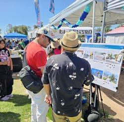
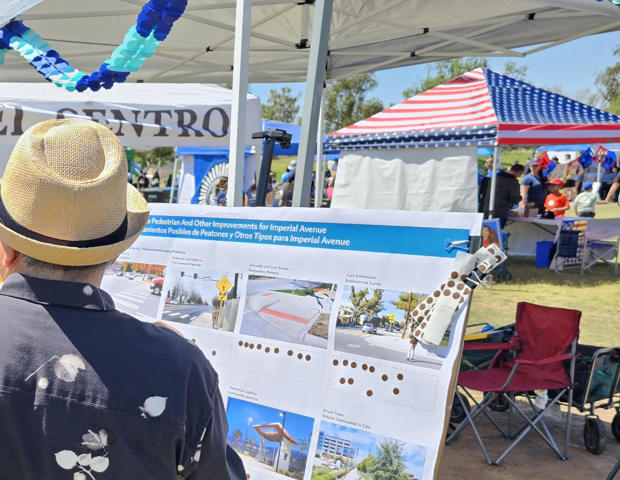
3.5 Pop-Up Events
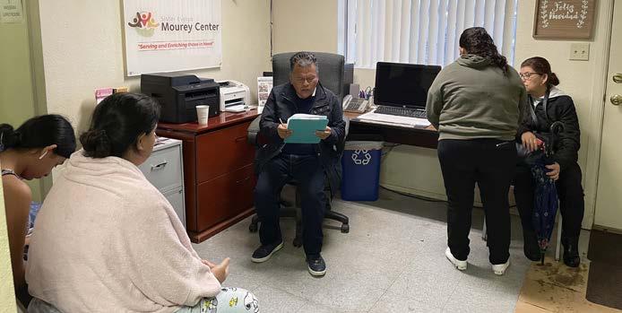
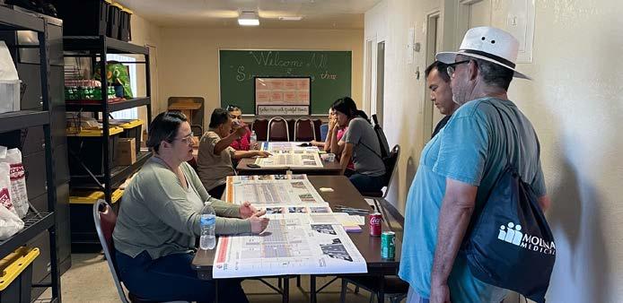
Pop-Up #1 - Sister Evelyn Mourey Center (January 22, 2024)
The first pop-up event was hosted at the Sister Evelyn Mourey Center on January 22, 2024, to talk with residents about their safety concerns along the corridor. Despite the inclement weather, nearly 40 people came out to share input. Some key takeaways were concerns about the nearby Imperial Avenue and Pico Avenue intersection crossing times being too short to safely cross. Residents shared that crossings generally feel unsafe along Imperial Avenue, especially for vulnerable populations such as seniors and people with mobility aids or disabilities.
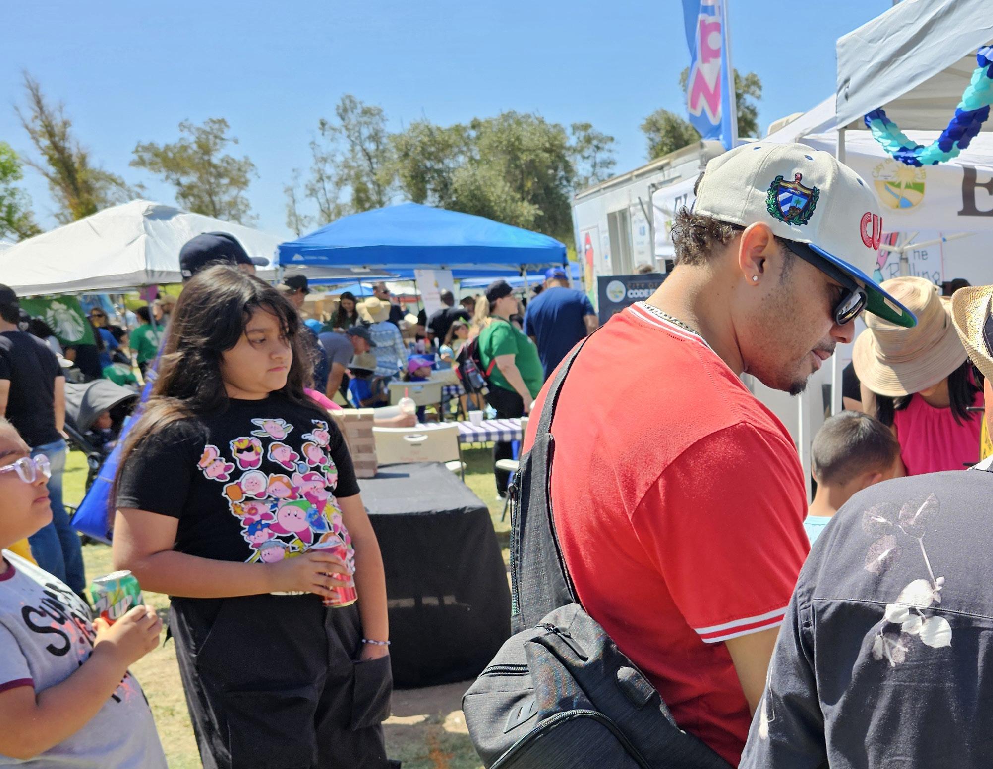
Pop-Up #2 - Children’s Fair (April 13, 2024)
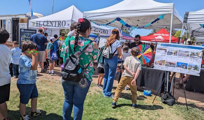
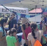
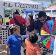
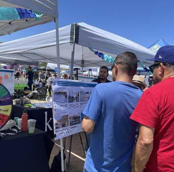
On Saturday, April 13, a second pop-up was held during the Children’s Fair, a family-friendly day with live music, games, animals, and food. To attract community members to participate, a booth was set up along with games and activities such as corn hole and a spin the prize wheel. The goal of the pop-up event was to inform the public about the results from the existing conditions analysis and capture feedback from residents to help guide the project team through the preliminary design phase.
Upon engaging with the public, some key takeaways were the barriers transit riders face, where people feel the most safe crossing Imperial Avenue on bicycles, and insight on the challenges of walking along Imperial Avenue.
Top 3 Desired Improvements by Mode
Street trees
Curb extensions
Pedestrian Hybrid Beacons (PHB),
Class I Multi-use Path
Class IV Separated Bikeways
Bike Parking
Bus shelters with protection from weather
Improved ADA access at bus stops
More bike rack capacity on the front of buses
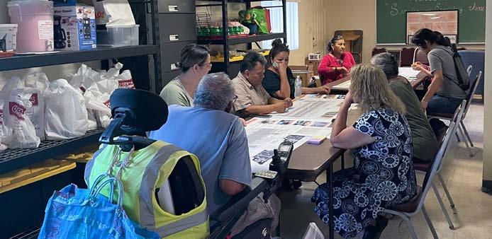
Pop-Up #3 - Sister Evelyn Mourey Center (August 9, 2024)
Pop-up three was hosted at the Sister Evelyn Mourey Center a day after Workshop #2 to continue gathering input on the draft recommendations for Segments A, B, and C. All material provided during the pop-up were the same as Workshop #2. Approximately 30 attendees shared suggestions for all three segments of the Imperial Avenue study area as well as three locations for new traffic signals. All attendees left with bags of food and other goodies as a thank you for participating.
Common themes were interest in drought tolerant street trees for shade, pedestrian-scale lighting, and increased crossing times for pedestrians.
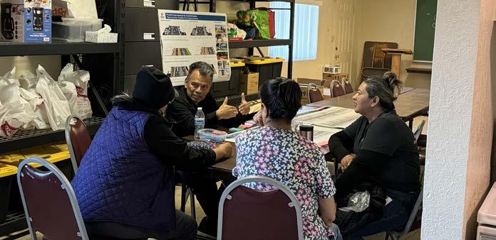
Pop-Up #4 - Sister Evelyn Mourey Center (November 15, 2024)
A final pop-up was hosted at the Sister Evelyn Mourey Center a day after Workshop #3 where approximately 53 participants received a voucher for a free turkey as Thanksgiving Day approached. Due to space constraints, the corridor was shared similarly to Workshop #3 but at a smaller scale.
Participants expressed their overall satisfaction with the recommendations and gratitude for the proposed sidewalks and crosswalks as some of their concerns remained for sidewalks, crosswalks, lighting, and enhanced safety for people of all abilities. Participants emphasized the continued need for improved visibility for pedestrians, as well as level and continuous sidewalks to accommodate people with mobility aids.
It’s intimidating crossing the street, even when there are crosswalks. “ ”
There are long stretches between crossings. ” “
A lo largo de Imperial Avenue faltan sombras en las paradas de camión. “ ”
Participant Quotes
Los automovilistas no respetan a los peatones. “ ”
3.6 Public Engagement Overarching Themes
Community members shared a range of comments and concerns throughout the public engagement process. The following are some of the overarching themes and ideas desired that influenced the proposed design for Imperial Avenue.
Coordinate opportunities for more bus stops and enhanced shelters with ICTC.
Explore opportunities for pedestrian-scale lighting.
Maintain existing lanes for automobiles.
Continuous sidewalks for connectivity and accessibility.
Pedestrian crossings for improved east-west connections.
Urban greening for shade during hot weather.
Explore protected space for bicyclists.
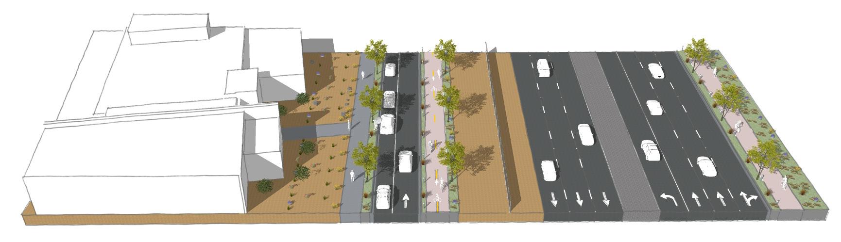
4.1 Complete Streets Toolkit
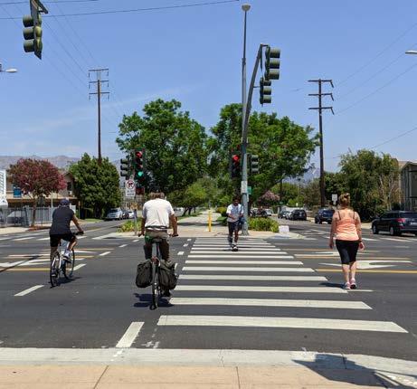
A wide range of infrastructure elements exist that can be incorporated in the development of Complete Streets. Each potential improvement will need to be evaluated further on a case by case basis during the final design and implementation phase. The following section outlines a ‘toolkit’ which includes different categories and types of street treatments that are often found or can be incorporated in the development of Complete Streets. Several of these elements can be found in the Imperial Avenue Preferred Concept described later in this chapter. The corresponding regulations, policies, guidelines, and standards should be further analyzed and followed upon implementation. Pedestrians
4.1.1 Pedestrian Facility Enhancements
Imperial Avenue is an auto-centric corridor and main truck route. Therefore, pedestrians often opt for the use of motor vehicles as a safer mode of travel to, from, and throughout the corridor. Pedestrian facility enhancements can be incorporated throughout Imperial Avenue for a safer and more accessible environment.
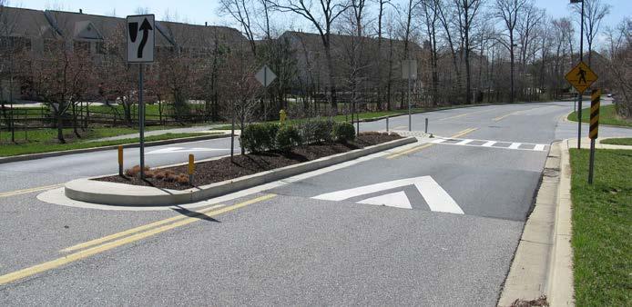
Pedestrian Refuge Islands (Median Refuge Islands)
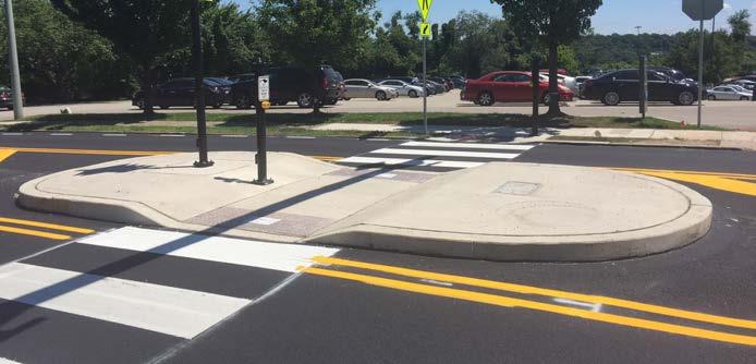
Pedestrian refuge islands or median refuge islands are raised protected spaces in the center of the streets, creating a safe space for pedestrians and bicyclists to wait as they cross one direction of the street to another.1 This is beneficial to pedestrians and bicyclists when they have to cross major streets.
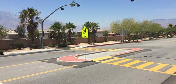
Mid-Block Crossings
Mid-block crossings provide a convenient location for pedestrians to cross the street where intersection crossings are far apart, preventing out-of-route travel for pedestrians. These types of crossings are typically developed where common use occurs such as schools, parks, and everyday uses.2
Curb Extensions (Bulb-outs or Neck-downs)
Curb extensions are also referred to as bulb-outs or neck-downs and shorten the distance needed for pedestrians to travel when crossing the street. This is due to the offset of the curb into the street that increases the pedestrian area and encourages drivers to make slower turns. Curb extensions can also be used along streets, supplementing on-street parking space and an opportunity for increased street furnishings and landscaping.3
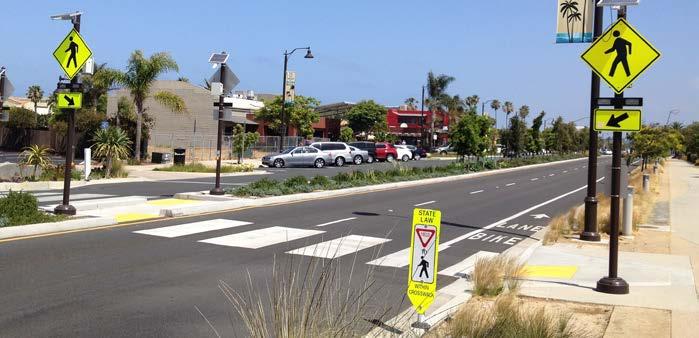
Pedestrian-Scale Lighting
Pedestrian-scale lighting provides many practical and safety benefits, such as illuminating the path and making crossing walkers and bicyclists more visible to drivers. Lighting can also be designed to be fun, artistic, and interactive.
Pedestrian Refuge Island
Mid-block crossing with Pedestrian Refuge Island
Curb Extension
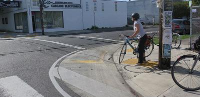
4.1.2 Conventional Bicycle Facility Types
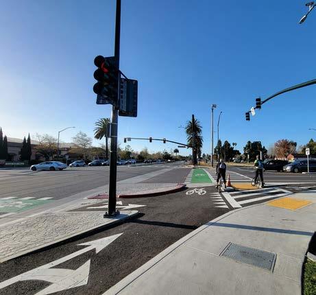
In the state of California, four conventional bicycle facility types are recognized by the California Department of Transportation and guidance on standards and specifications are found in the California Manual on Uniform Traffic Control Devices (CA MUTCD)4 and CA Highway Design Manual (HDM)5. The numerical designation of bicycle facility types does not represent a hierarchy and application of each should be considered where deemed appropriate.
According to the National Association of City Transportation Officials (NACTO)6, the benefits of conventional bike lanes are:
The increase of bicyclist comfort and confidence on busy streets.
The creation of separation between bicyclists and automobiles.
Increased predictability of bicyclist and motorist positioning and interaction.
Increased capacity of streets carrying mixed bicycle and motor vehicle traffic.
Visually reminds motorists of bicyclists’ right to the street.
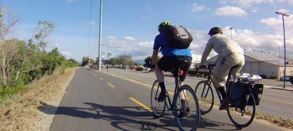
Class I Multi-Use Paths (Bicycle Path)
Class I multi-use paths, frequently referred to as “bicycle paths”, are two-way facilities physically separated from motor vehicle routes that grant exclusive right-of-way to non-motorized users, like pedestrians and bicyclists. They require physical buffers to ensure safety and comfort of the user.
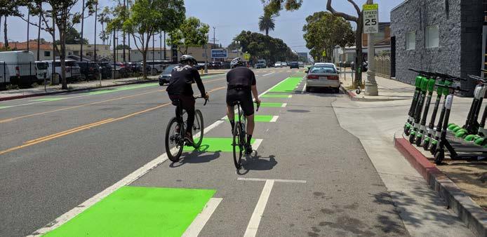
Class II Bicycle Lanes
Class II bicycle lanes are one-way facilities that dedicate right-of-way to bicyclists within the same direction of roadway adjacent to motor vehicles. They are not physically separated from motor vehicle traffic. For this reason, Class II bicycle lanes can include an additional buffer striping space whenever possible to reduce the risk of collision between bicyclists and motor vehicles.
Class I Multi-Use Path
Class II Bike Lane
Class IIB Buffered Bike Lane
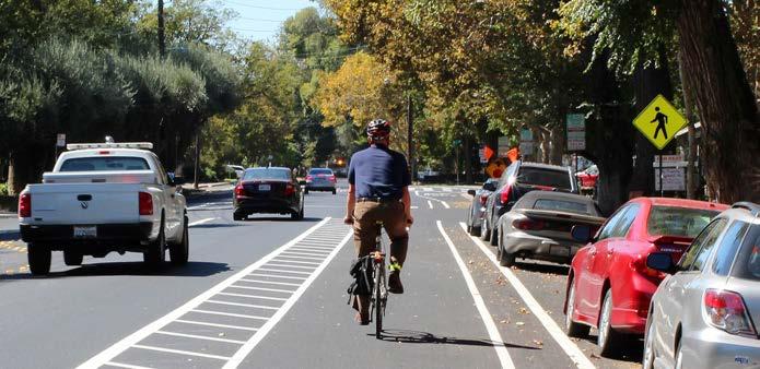
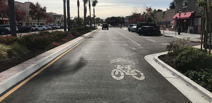
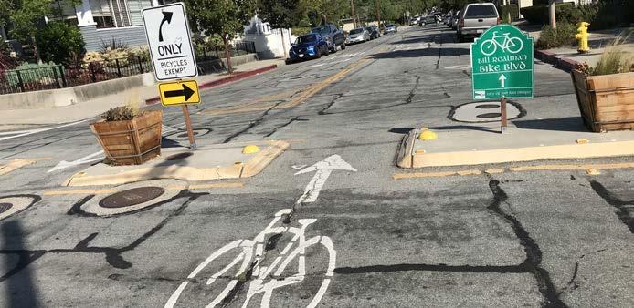
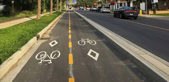
Class III Bicycle Routes
Class III bicycle routes, are one-way shared facilities typically on low speed and low volume roadways where bicyclists and motorists are expected to share the road. Therefore, these roadways can be designated as bicycle boulevards/neighborways with enhancements that include signing and pavement markings, volume management strategies, and speed management strategies such as neighborhood traffic circles.
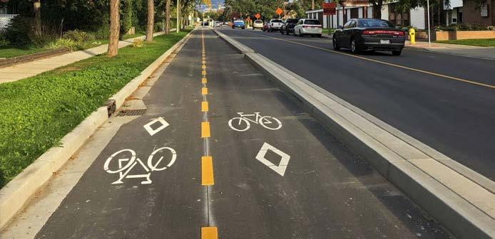
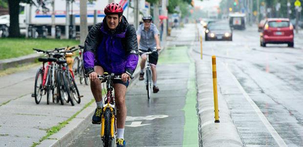
Class IV Separated Bikeways (Cycle Track)
Class IV Separated Bikeways, also commonly referred to as “cycle tracks”, are one-way or two-way on-street bike facilities that include horizontal and vertical buffer separation from vehicles for increased bicyclist safety. Class IV separated bikeways are for the exclusive use of bicycles and may be raised.
4.1.3 Enhanced Bicycle Facility Types Treatments
To create Complete Streets, enhancements to the different bicycle facility types can be low cost and be effective in increasing safety for all users. Installation of the following outlined enhancement can often be coordinated with street resurfacing projects.
Buffered Bicycle Lanes
Buffered Bicycle Lanes provide an additional space between bikeways and motor vehicles for increased comfort and safety. Buffers are created through but are not limited to road markings, posts, barriers, on-street parking, and landscaping. The buffer also encourages bicyclists to avoid riding too close to parked vehicles, keeping them out of the “door zone” where there is the potential danger of drivers or passengers suddenly opening doors into the bicyclists’ path.
Shared Lane Marking (“Sharrows”)
Sharrows are commonly used for Class III Bikeways when on-street parking is allowed adjacent to motor vehicle travel lanes. To ensure the adequate amount of separation between bicyclists, motor vehicles, and parked vehicles, sharrows are often centered within the rightmost travel lane.
Class III Bike Route with Sharrow Marking
Class IV Separated Bikeway (Two-Way)
Class IV Separated Bikeway (One-Way)
Bike Boxes
Bike Boxes are often installed at the front of travel lanes where signalized intersections are located and they designate bicyclists with a safe area to wait during red traffic signals.
Two-Stage Turn Box
A two-stage turn box is a designated waiting area at the right of a bike lane for bicyclists to advance in a multi-lane intersection or the left side of a bike lane if turning right.
Green Colored Conflict/Transition Striping
Green-colored striping can be used to highlight conflict areas between bicyclists and vehicles, such as where bicycle lanes merge across vehicle turn lanes or driveways.
Colored Bike Facilities
Colored Bike Facilities consist of colored pavement that increases visibility of bikeways and can help minimize bicyclists and motor vehicle collisions. Green-colored pavement for bicycle facilities is the standard in California and limitations include but are not limited to bicycle lanes, two-stage turn boxes, and separated bikeways within the roadway. For the full list of limitations and standards refer to Part 9 Traffic Control for Bicycle Facilities of the CA MUTCD.
4.1.4 Low Stress Bicycle Facility Types
In the process of creating safer, more comfortable, and equitable Complete Streets, the City of El Centro may find that in some cases the conventional bicycle facility types may not meet the needs of the community. Therefore, this section outlines a comprehensive list of low-stress bicycle facility types that are used in different parts of the country successfully and can be found in the NACTO Urban Bikeway Design Guide or AASHTO Guide of the Development of Bicycle Facilities.
Neighborway/Bike Boulevards
A neighborway, sometimes called a bike boulevard, is an approach to reduce traffic, slow car speed, and improve safety for those biking,
Two-stage Turn Box
Green Colored Conflict/Transition Striping
Bike Boulevard
walking, and rolling on quiet residential streets. They are typically located on more narrow, slow speed streets and combined with other traffic calming infrastructure like speed tables.
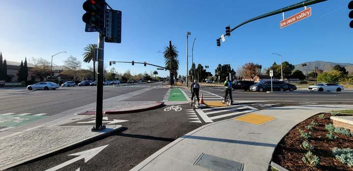
Protected Intersections
Protected intersections maintain physical separation between bicyclists and motor vehicles, creating a higher sense of safety and comfort. Protected intersections are set back from motor vehicles and bicyclists are not obligated to merge with traffic because they are provided a dedicated path.
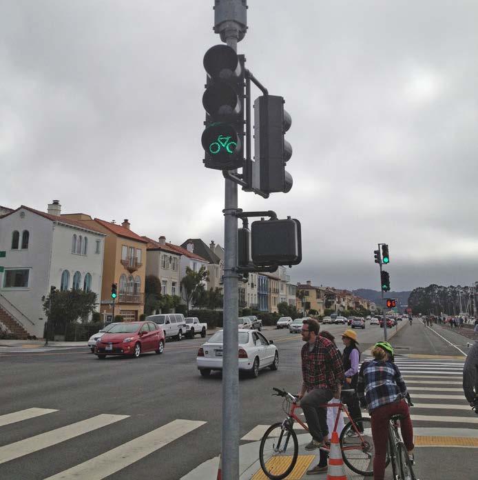
Bicycle Signals
Bicycle signals, also referred to as bicycle beacons, are typically three lens signal heads with green, yellow, and red bikeway icons. They allow bicyclists to have clarity when met with intersections and make crossing intersections safer. The use of bicycle signals is dependent on a variety of factors such as speed limits, bicycle crossing traffic, and planned or existing bicycle facilities.
Bicycle Detection
Bicycle detection is used at actuated signals which prioritize movement along primary corridors. Actuated signals can create conflicts for pedestrians if it is timed for the prioritization of motor vehicles.
Bicycle signals at activated signals alert the signal controller that a bicycle crossing event has been requested. However, bicycle detection can occur automatically or by the use of a push button.
Protected Intersections
Bicycle Signals
4.1.5 Traffic Calming
Traffic calming is a process that involves changes in street alignment, installation of barriers, and other physical measures to minimize collisions between vehicles and pedestrians. The intent of traffic calming is to decrease the negative impact to pedestrians, bicyclists, and residents that is caused by reckless driving. Successfully implementing traffic calming measures can increase street safety - making the city a more livable place.
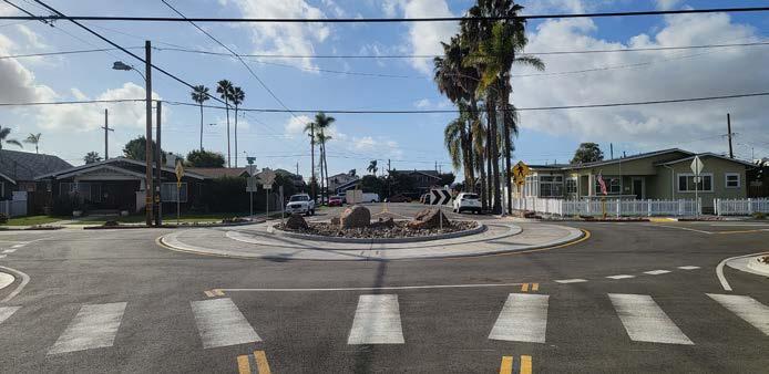
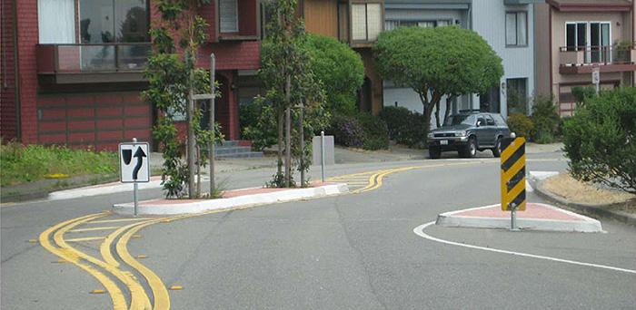
Traffic Roundabout/ Traffic Circle
Traffic roundabout and traffic circles are traffic calming measures that slow and divert traffic to nearby streets, reducing right-of-way conflicts between bicyclists, pedestrians, and motor vehicles. However, traffic roundabouts consist of intersection points with yield control at its entry that allows a driver to proceed at controlled speeds in a counter-clockwise direction around a central island. Traffic circles on the other hand are often used on bicycle boulevards and on low volume residential streets to avoid or reduce right-of-way conflicts because the overall footprint is smaller when compared to roundabouts.
Signals and Warning Devices
Signals and warning devices are used to warn and control traffic at unsignalized intersections and other locations to assist pedestrians when crossing the street. Pedestrian Hybrid Beacons (PHB) and Rectangular Rapid Flashing Beacons (RRFB) are typical signals used in lower volume and lower speed streets.
Speed Humps (“Bumps”) and Speed Cushions (Speed
Humps)
Speed humps or “bumps”, slow traffic speeds on low volume and low speed streets due to their protruding parabolic shape. Speed cushions are similar to speed humps with the exception of including wheel cutouts and extending longitudinal for larger vehicles to pass safely.
Traffic Circle
Signals and Warning Devices
Class IIB Buffered Bike Lane
Speed Tables (Raised Crosswalks)
Speed tables or raised crosswalks are a midblock traffic calming measure that allow pedestrians to cross a street when intersections are too far apart. Speed tables are similar to speed humps but are longer and flat-topped that reduce speeds and enhance pedestrian safety.
Speed Displays
Speed displays measure the speed of approaching vehicles by radar and an LED display to inform drivers of their speeds, creating awareness of how fast they are traveling and effective in reducing motor vehicle speeds.
Reflective Border on Signal Head
Reflective borders on signal heads improves visibility of signal heads with a backplate and is made even more conspicuous by framing it with a yellow retroreflective border. These are more visible in both daytime and nighttime conditions.
Chicanes
Chicanes are a traffic calming measure that through a series of narrowing or alternating curb extensions increase the amount of public space and reduce traffic speeds.
Truck Aprons
Truck aprons allow large vehicles: trucks, buses, and recreational vehicles, to turn without striking pedestrians walking, rolling, bicycling, or any fixed objects. They are typically slightly raised pavement located between the road surface and the sidewalk, or the inner circle of a roundabout due to large vehicle turning radius.
On-Street Edge Friction
On-street edge friction is created by a combination of vertical speed control elements such as on-street parking, bicycle facilities, chicanes, curb extensions, site furnishings, and landscaping that reduces the apparent width of the street. Not only does this create a safer environment, it can make walking and biking more attractive for pedestrians.
Speed Tables
Chicanes
Truck Apron
4.1.6 Green Street Improvements
Green street improvements incorporate tried and true stormwater management practices into transportation infrastructure to reduce stormwater runoff, prevent flooding, improve water quality, provide habitat for local flora and fauna, and create an enjoyable streetscape. These improvements can be installed alongside sidewalks, roadways, parking lots, medians, and more to create a more sustainable and resilient corridor. The green street improvements listed below are from the U.S. Environmental Protection Agency’s Green Streets Handbook.7
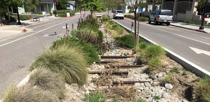
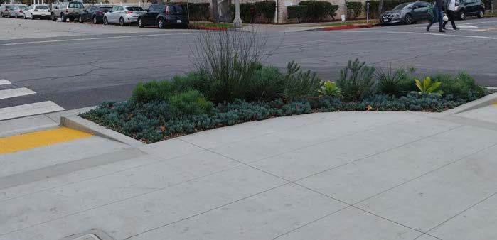
Bioretention Area
A bioretention area, or rain garden, is a shallow surface depression planted with vegetation to retain, infiltrate, and filter stormwater runoff and pollution. Bioretention areas can vary in size, shape, and site and can take the form of cells, rain gardens, or bioswales. Bioretention areas can be located on sidewalks, street frontages, intersections, road medians, road shoulders, and parking lot islands or perimeters.
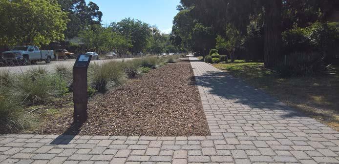
Permeable Pavement
Permeable pavements allow stormwater runoff to infiltrate through void space into the ground below or another stormwater management system instead of becoming surface runoff. Types of permeable pavement include porous asphalt, porous recycled surface products, pervious concrete, and pavers arranged with void spaces. Permeable pavement can be used instead of impervious materials on parking lots, parking lanes, driveways, sidewalks, walking paths, bicycle lanes, parkways, road shoulders, and low-traffic roads.
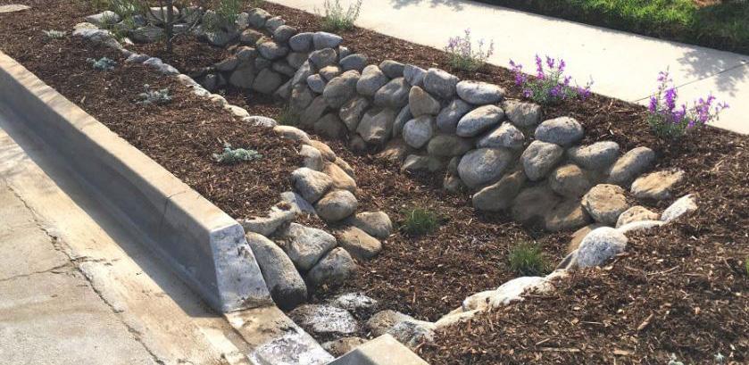
Stormwater Curb Extensions
Stormwater curb extensions, or stormwater bump outs, combine two street improvements - traffic calming and stormwater filtration - to produce multiple streetscape benefits. This strategy involves filling the area behind the curb with a bioretention soil media and vegetation similar to a bioretention cell or bioswale. Stormwater curb extensions can be located at intersections, midblock crossings, neighborhood or collector streets, or any length of a roadway.
Bioretention Area
Permeable Pavement
Stormwater Curb Extensions
Stormwater Curb Cuts
A curb cut is a cut in into a curb allowing for easier water access for collection and percolation of stormwater.
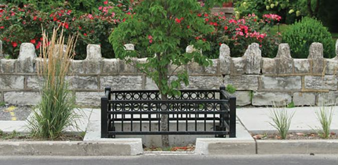
Stormwater Tree Systems
Stormwater tree systems, such as tree pits or tree trenches, contain a tree or shrub planted in a bioretention soil mix and a gravel reservoir designed to capture stormwater. Stormwater tree systems are typically located along sidewalks, medians, and parking lots and receive stormwater runoff through a curb cut, catch basin, or stormwater inlet.
Mini Parks (Pocket Parks)
Mini parks or “pocket parks” are small outdoor spaces found in already built out cities and can be designed in smaller lots than typical parks.8 They offer an opportunity to integrate green infrastructure treatments in an urban environment to create socializing and resting spaces along a corridor which can also support placemaking.
Stormwater Curb Cuts
Stormwater Tree Systems
Mini Park
4.1.7 Placemaking
Cities can feel like built-out spaces but communities can continue to be improved and built around existing places. Placemaking started as a concept credited to prominent historical figures in the field of city planning and it has been adopted as an approach to designing and managing public spaces, or the public realm, to strengthen connections between people and spaces. The City of El Centro can adopt some of the following placemaking elements on Imperial Avenue that can contribute to the creation of a Complete Street.
Signage and Wayfinding
Signage and wayfinding creates a system that allows pedestrians and bicyclists better awareness and orientation for increased safety. Signs may be placed at important points and locations to call attention to users and inform them of any road changes as well as an opportunity for the City to incorporate branding.
Street Furnishings and Public Art
Furnishings are an important part of encouraging the use of alternative modes of transportation and can help steer away from autocentric streets by providing shelter, bike racks, seating, and other amenities for people of all ages. Furnishings such as bus shelters and trash receptacles are opportunities for the city to incorporate branding and public art from local artists. Enhancing the public realm visually while also being functional can draw more people to walk, bike, and roll.
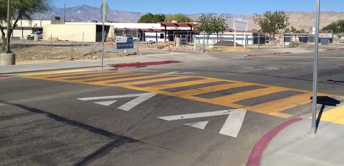
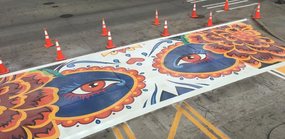
Intersection Paving and Crosswalk Art
Special intersection paving and crosswalk art provide unique opportunities to highlight crossings at key locations while simultaneously integrating context-sensitive art. They are a great opportunity to incorporate culturally representative local art of El Centro. Paving treatments and crosswalk art do not define a crosswalk and should not be seen as a safety measure. Standard transverse or longitudinal high-visibility crosswalk markings are still required.
Signage and Wayfinding
Public Art
Crosswalk Art
4.1.8 Transit/New Mobility
New mobility refers to evolving and emerging forms of clean and/or shared forms of transportation, which can include micromobility, ride-hailing, carpools, and automated and connected vehicles. These forms of transportation can provide alternatives to gas-powered, single-occupancy cars and help reduce air pollution and GHG emissions. Clean mobility and shared options also help address transportation equity by providing affordable transportation choices for lower-income households and those who are unable to drive or own a car.
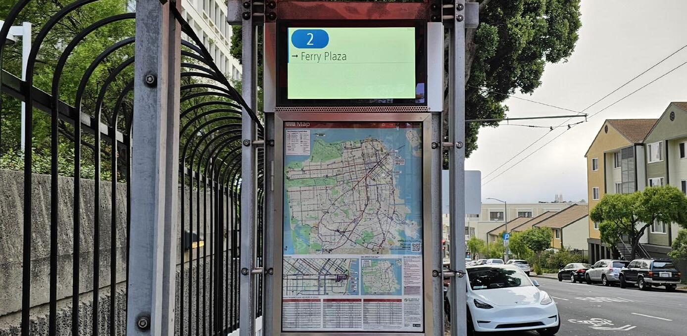
Real-Time Bus Information
Real-time bus information allows riders to predict their journey and manage their time more effectively. This increases the convenience of transit for riders by providing accurate, updated location of their bus.
Transit Stop Amenities
Transit stop amenities such as shelters with overhead protection, seating, trash receptacles, and lighting are essential for encouraging people to use public transit.
Floating Bus Island
A floating bus island is located between travel lanes and bicycle lanes where transit passengers board and alight transit vehicles. Pedestrians cross the bicycle lane when traveling to or from the platform where the bus stop is located. This eliminates conflict between bicyclists traveling in bicycle lanes and transit vehicles that must pull curbside to load and unload passengers.
Electric Shuttles
Electric shuttles can help address gaps within a community by supplementing the existing transit network or by creating new transit routes where they currently don’t exist. Depending on the make and model, electric-powered shuttles can be used to offer transit services within a specified radius.
Real-time Bus Information
Transit Stop Shelter
Floating Bus Island
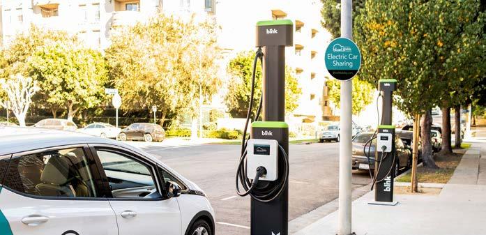
Carsharing Service
An electric carsharing service could be established by purchasing a fleet of electric cars. These cars could be rented by residents to address their transportation needs, such as commuting to work, running errands, or getting to medical appointments. The City would have its own EV charging infrastructure which could be combined with other electric mobility options, such as electric shuttles and electric vanpool/carpool services.
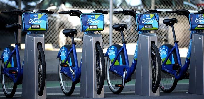
Bikeshare
Docked bikeshare is a shared transport service in which bicycles or e-bicycles are made available for shared use to individuals on a short-term basis for a price or for free. Docked bikeshare systems allow people to borrow a bicycle from a “dock” or station and return it to another dock belonging to the same system. Docked bikeshare systems often include electric-assist bicycles that provide extra comfort for users.
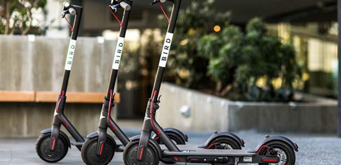
E-Scootershare
Scootershare programs are popular forms of shared transportation services that involve the rental of electric motorized scooters for short trips. These programs involve the use of a mobile app to look for, rent, pay, and park the rented scooter. Scootershare programs provide a high degree of flexibility for the individual user and can be an effective method for closing mobility gaps. Short trips to visit family members and access to schools, parks, commercial areas, and transit stops are all possible with a scootershare program.
Carsharing
Bikeshare
E-scooter
4.2 Goals, Objectives, and Actions
Policies that contain goals, objectives, and actions were developed to assist El Centro staff implement the preferred concept. These policies were developed using the existing conditions analysis, public engagement process, and feedback from city staff.
Goal 1: Provide Safe Modes of Transportation for Pedestrians, Bicyclists, and Drivers
As a part of a Complete Street, providing safety for all modes of transportation for people of all ages and abilities is vital and can be pursued through strengthened connectivity, an enhanced network, and the implementation of Complete Street principles.
Objective 1 Improve pedestrian connections for increased safety and comfort.
Action 1.1 Implement the currently adopted Active Transportation and Safe Routes to School Plan to increase the number of pedestrian and bicyclist trips from everyday destinations and transit stops.
Action 1.2 Update the Active Transportation and Safe Routes to School Plan to meet future trends and re-engage community members on existing conditions and opportunities.
Action 1.3 Implement high-visibility crosswalks and accessible pedestrian signals at high-volume intersections.
Action 1.4 Identify opportunities to add or enhance safe bicycle and pedestrian crossings along Imperial Avenue that connect to major destinations.
Action 1.5 Mitigate the impact of vehicular traffic to the pedestrian public realm by identifying and establishing curb extensions at intersections.
Objective 2 Create a safe bicyclist network that encourages use of active transportation.
Action 2.1 Identify hot spot locations of bicycle and pedestrian collisions with motor vehicles to develop countermeasures such as midblock crossings, bicycle facilities, and bicycle signals.
Action 2.2 Install bicycle facilities that connect to proposed pathways and future transit stops along Imperial Avenue.
Action 2.3 Identify a curb space management program that could be prioritizing adapting curb space, specifically in front of commercial area, to the current needs of the corridor such as bicycle parking, rideshare pick-up/drop-off, and pedestrian amenities.
Objective 3 Promote safe driving through Complete Street principles.
Action 3.1 Construct raised medians or hardened centerlines where applicable to improve traffic safety.
Action 3.2 Traffic-calming tools should be considered along Imperial Avenue where joined to collector streets.
Action 3.3 Repurpose unneeded right-of-way where space allows to implement bicycle and pedestrian improvements.
Action 3.4 Implement traffic calming measures and programs that encourage safe driving.
Action 3.5 All signalized arterial intersections should integrate monitoring and traffic flow control infrastructure for future roadway improvements and maintenance.
Goal
2: Increase Opportunities for Equitable
Access
Imperial Avenue as a highly used corridor at the heart of El Centro and is a major connector that can increase opportunities for equitable access for all users. Imperial Avenue as a Complete Street has the potential of enhancing safety for pedestrians walking, bicycling, rolling, using public transit, and driving.
Objective 1 Prioritize the needs of underinvested and underserved transit users.
Action 1.1 Pedestrian and bicycle crossings should be accessible by all and include safe traffic signals, marked crosswalks, and follow ADA guidelines.
Action 1.2 Improved pedestrian treatments for a safer walking experience should be prioritized at the intersection of Adams Avenue and Imperial Avenue due to the future planned improvements for Opportunity Area 1 as stated within the El Centro General Plan Update.
Action 1.3 The City of El Centro should coordinate with the City of Imperial to align efforts to promote bicycle connections and enhance public transportation connections.
Action 1.4 Focus complete street principles along Imperial Avenue and create connections to vital services like health and wellness services, recreational uses, and retail food services.
Action 1.5 Incorporate the identified Complete Streets goals, objectives, and actions in a sensitive manner that recognize the different needs among neighborhoods and communities.
Action 1.6 Imperial Avenue should be universally accessible and accommodate children, seniors, and people of all abilities.
Objective 2 Explore implementation of programs and projects that reduce transportation costs.
Action 2.1 Coordinate with Imperial Avenue Transit (IVT) to improve access for those who work, live, and play along Imperial Avenue per Public Right-of-Way Accessibility Guidelines (PROWAG) and compliance with the Americans with Disabilities Act (ADA).
Action 2.2 Implement projects identified in Public Works’ ADA Self-Evaluations and Needs Assessments.
Action 2.3 Innovative technologies or smart transportation programs should be incorporated to increase efficiency.
Action 2.4 Identify, increase, and maintain shared mobility programs for the population who is highly-dependent on alternative modes of transportation.
Action 2.5 Increase transportation options between employers and employees commuting to Imperial Avenue from areas with limited transportation access.
Objective 3 Create connected multimodal networks that meet the needs of all users.
Action 3.1 Imperial Avenue lane widths should be minimized where appropriate to discourage high vehicle speeds and to shorten pedestrian crossing distances.
Action 3.2 Introduce traffic calming elements and bicycle and pedestrian amenities to slow vehicle speeds along Imperial Avenue, such as at intersections and midblock crossings.
Goal 3: Provide a Reliable Corridor to Promote the Use of Public Transit
Designing a Complete Street includes providing the necessary infrastructure improvements for the use of public transit along Imperial Avenue which takes riders to their desired destinations along the corridor, throughout El Centro, and neighboring communities. Therefore, Imperial Avenue should be designed to be a reliable means for public transportation.
Objective 1 Identify and provide safe and pleasant bus shelters along Imperial Avenue.
Action 1.1 Enhance the Imperial Avenue streetscape by following adopted bus shelter guidelines to encourage the use of public transit.
Action 1.2 Enhance bus stop and waiting area amenities along the Imperial Avenue corridor by providing seating, shade, lighting, real-time travel informational displays, and trash receptacles.
Action 1.3 Coordinate with Imperial Valley Transit (IVT) and Imperial County Transportation Commission (ICTC) to provide bus shelters and waiting area in locations that accommodate Imperial Avenues future growth as identified in El Centro General Plan and supporting documents.
Action 1.4 Locate areas where there is a possible need for rideshare pick-up and drop-off joint bus shelter waiting areas.
Objective 2 Enhance streetscape along Imperial Avenue transit routes to promote use of bus stops.
Action 2.1 Revitalize and enhance pedestrian and bicycle infrastructure through coordination with future Visual Enhancement Area (VEA) plans or guidelines. El Centro General Plan identifies Imperial Avenue as a VEA.
Action 2.2 Streetscape should acknowledge cultural and environmental considerations.
Action 2.3 Install sidewalks where currently missing to create a consistent public right of way that creates areas for future transit stops.
Objective 3 Create a secure environment/corridor for pedestrians and traffic at bus stops and transit centers.
Action 3.1 Provide direct access to transit facilities and ensuring visibility to and from vehicles by avoiding blind spots often created by inappropriate landscape, fencing, and other structures.
Action 3.2 Provide and maintain lighting at all transit facilities (i.e., bus stops, bus shelters, transit center).
Objective 4 Encourage public transit improvements between neighboring cities.
Action 4.1 The City of El Centro should coordinate with Imperial County Transportation Commission (ICTC), Caltrans, and neighboring cities to identify necessary regional roadway improvements for improved transit access between El Centro and adjacent cities. Action 4.2 Foster relationships with adjoining communities identified in the El Centro Vision 2050 Strategic Plan for the improvement of adjoining roadways.
Action 4.3 Promote the use of public transportation options offered along Imperial Avenue that can improve the reach of transit for El Centro residents.
Action 4.4 Monitor and evaluate the need to implement transit priority treatments, such as dedicated bus lanes, queue jumper lanes, and transit signal priority strategies, to improve transit ontime performance and reliability.
Goal 4: Design a Comfortable and Sustainable Street Environment
Designing and creating a comfortable and sustainable street environment impacts community well-being and identity along Imperial Avenue. Comfort can be enhanced by creating space for pedestrians and bicyclists and sustainability improved by implementing a visually appealing streetscape through thoughtful placemaking and urban greening. With these improvements, Imperial Avenue can be a vibrant corridor encouraging physical activity and strengthening community ties.
Objective 1 Design Imperial Avenue as a comfortable environment that promotes physical activity.
Action 1.1 Prioritize establishing a sidewalk network that is safe and accessible with pedestrian amenities that connect pedestrians to schools, shopping, dining, parks, medical facilities, and public facilities.
Action 1.2 Sidewalks and pedestrian crossings should be continuous and free of obstructions to ensure adequate capacity and comfort.
Action 1.3 Promote and support sustainable transportation choices such as shuttle services, direct transit routes, or rideshare programs.
Objective 2 Reinforce community culture and identity through sustainable design solutions.
Action 2.1 Opportunities should be identified along Imperial Avenue where trees and landscaping can be incorporated to provide a “green corridor” to strengthen community identity, character, and culture.
Action 2.2 Buffers with urban greening should be considered along the corridor to create shade and decrease the heat island effect.
Action 2.3 Consider the implementation of an “Adopt a Tree Program” to enhance the public realm of Imperial Avenue.
Objective 3 Design a visually attractive streetscape through placemaking.
Action 3.1 Integrate new signage, wayfinding, decorative lighting, branding, and public art into the bicycle and pedestrian network; and near identified key locations.
Action 3.2 Opportunities for the integration of public art should be explored at crosswalks and intersections.
Action 3.3 Coordinate with the appropriate Visual Enhancement Area Plans for the development of future gateways and wayfinding along Imperial Avenue.
Action 3.4 Utilize streetscape to provide a visually attractive and physically comfortable environment that promotes environmental justice.
Action 3.5 Coordinate the relocation or visual improvement strategies of utilities with utility companies to allow space for complete street elements.
Goal 5: Coordination with Future Citywide Improvements
As El Centro continues to flourish, Imperial Avenue will need to adapt to the community’s changing needs as demand for multimodal transportation increases. City staff should work to develop a Complete Street and plan to maintain and invest in the continuous betterment of Imperial Avenue with the present and future in mind.
Objective 1 Encourage open communication and coordination among City departments and agencies for successful implementation of Complete Street Strategies.
Action 1.1 Dedicate staff time to create an advisory committee that meets routinely to guide the implementation of the Imperial Avenue Complete Streets Plan.
Objective 2 Ensure the planning process incorporates best practices for implementation.
Action 2.1 Develop a phased implementation strategy for incremental improvements.
Action 2.2 Incorporate Complete Street policies into future planning documents.
Objective 3 Construct, maintain, and invest in an infrastructure for all.
Action 3.1 New development should promote connectivity through direct and safe pedestrian connections to parks, schools, shopping, medical facilities, and employment destinations.
Action 3.2 Ensure new development provides a roadway, pedestrian, and bicycling network that meets the needs of future development.
Action 3.3 The City is encouraged to work with existing and future developments to continue the street grid network of short blocks for enhanced connectivity.
Action 3.4 Maintain facilities to meet the needs of the community.
Action 3.5 Plan, construct, and maintain infrastructure to avoid future upsizing while meeting future growth goals.
Action 4.1 Partner with schools to ensure transportation facilities such as sidewalks and bicycle lanes are suitable for students.
Action 4.2 New developments should extend improvements to the public realm/public right of way.
Objective 5 Pursue Federal and State infrastructure funding to improve and maintain corridor.
Action 5.1 Create a walkable corridor by identifying sidewalk gaps along Imperial Avenue and seek funding to fill in gaps.
Action 5.2 Identify funding sources to fund ongoing routine maintenance of sidewalks, roadways, and transit amenities/facilities.
4.3 Imperial Avenue Preferred Concept
The following section depicts the Preferred Complete Streets Concept that is based on extensive analysis of Imperial Avenue, feedback received throughout the public engagement process, and coordination meetings with City Staff. The Preferred Concept includes recommended Complete Streets Toolkit treatments such as:
Class I Multi-use Path
Class IV Separated Bikeway
Green conflict striping/transition striping where bike facilities intersect with driveways
High Visibility Crosswalks (Sidewalk Art Opportunity)
Pedestrian-scale Lighting
Medians (Green Street Infrastructure Opportunity)
Placemaking (Mini/Pocket Park Opportunity)
Wayfinding and Signage at key points along the entire corridor
Enhanced Bus Shelters (Floating Bus Island Opportunity)
The Preferred Complete Streets Concept has been developed as preliminary conceptual plans, found in Appendix A.5, along with three-dimensional sections and can be used by City Staff in the pursuit of funding for future implementation.
Implementation is recommended once the study area is relinquished to El Centro since at the time of the development of this CSP, Caltrans has ownership of the study area. While El Centro anticipates gaining control of the study area in the future, Caltrans reviewed and provided guidance — included in Appendix A.1.
“All these toolkit elements sound great!”
Segment A
Segment B
Segment C
Segment A
Segment A Summary
Segment A is the southernmost segment of the Imperial Avenue study area from Adams Avenue and Scott Avenue. This segment has existing sidewalks, bus shelters for bus lines 2 and 3, raised narrow medians, wide travel lanes, and a railroad crossing between Woodward Avenue and Scott Avenue. Attractions on this segment include take-out and dine-in eateries, hotel accommodations, and retail businesses. Although sidewalks exist along most of Segment A, they are missing or need improvement from Woodward Avenue to Scott Avenue on both the east and west sides. The railroad bisects this connection and grade changes along with drainage consid-
Recommendations
The proposed improvements for Segment A include the addition of a Class IV separated bikeway on both the east and west sides from Adams Avenue north towards the railroad crossing. At-grade railroad crossings, gates, and other safety equipment for pedestrians/bicyclists should be further evaluated in future studies. Considerations for elevation changes and ensuring ADA accessibility are essential. From the railroad crossing north towards Scott Avenue, Class I multiuse paths are proposed that can be used by both pedestrians and bicyclists. At the intersection of Imperial Avenue and Scott Avenue, a potential placemaking opportunity exists for the inclusion of a linear park with trees, landscaping, seating, wayfinding signage, public art, and more that can contribute to creating a gathering space to strengthen community character.
Note: El Centro
Figure 4-1: Segment A Preferred Concept
Note: Higher-resolution versions of these cutsheets can be found in the Appendix
Figure 4-2: Segment A Preferred Concept Sections
End of Segment A
Segment B
Segment B Summary
Segment B, Scott Avenue to Lincoln Avenue, is the middle segment of this study along Imperial Avenue. The segment has a frontage road on the west side for two-way traffic, a mixture of raised and earthen medians, and a lack of sidewalks on the east and west sides directly on Imperial Avenue. However, sidewalks exist along the western side of the Frontage Road. A key attraction on Segment B includes El Centro Library which offers informational, educational, cultural, and recreational materials and programming for the diverse community of El Centro. Other attractions include take-out and dine-in eateries, federal facilities, medical establishments, and retail businesses. Although not directly along the corridor, but important to highlight, are the park and school facilities on the west of Segment B, as they are major attractions for the community. Existing public transportation includes bus routes 2 and Green next to the El Centro Library.
Recommendations
Note: El Centro will need to verify speed reduction and final design requirements, such as Clear Recovery Zones (CRZ), during the engineering design phase
The proposed improvements for Segment B include the addition of a two-way Class IV separated bikeway on the east side of the frontage road from Scott Avenue north towards Lincoln Avenue. The two-way Class IV separated bikeway creates opportunities for the integration of urban greening, signage, and stormwater treatments on the west side of Imperial Avenue. A Class I multi-use path is another facility proposed on the east side of the entirety of Segment B. Class I multi-use paths can include a tree-lined buffer adjacent to Imperial Avenue that provides separation for bicyclists and pedestrians and provides stormwater catchment opportunities. The existing frontage road at the time of this study accommodates two-way traffic. However, it is recommended that it be converted to a one-way northbound travel lane. Additionally, along the east side of the frontage road, designated onstreet parking is proposed. Further study is recommended to coordinate with businesses and to study traffic flow along the frontage road to determine special access considerations. To accommodate the proposed northbound one-way couplet on Frontage Road, the southbound bus stop is relocated to Imperial Avenue with improvements such as a bus pad, bus shelter with seating and lighting, and wayfinding signage. On Imperial Avenue, two proposed signalized intersections fall within Segment B and are located at Villa Avenue and Lincoln Avenue. The proposed signalized intersections are recommended to include traffic signals, high-visibility pedestrian crossings, and adjusted signal timing.
Carlos Aguilar Park
Figure 4-3: Segment B Preferred Concept
Note: Higher-resolution versions of these cutsheets can be found in the Appendix
Figure 4-4: Segment B Preferred Concept Sections
End
of Segment B
Segment C
FROM TO
Segment C Summary
Segment C is the northernmost segment of this study from Lincoln Avenue to Treshill Road near the Central Drain and northern city boundary. This segment has wide earthen medians, a lack of sidewalks along the entire segment, and undeveloped shoulders with an earthen irrigation channel on the east side and a channelized flood control system on the west side. Attractions on this segment include take-out and dine-in eateries, places of worship, grocery stores, medical establishments, federal facilities, and retail businesses. Although there are no bus stops directly on this segment of Imperial Avenue, there is transit access nearby on Bradshaw Avenue and Cruickshank Drive.
Recommendations
The proposed improvements for Segment C include the addition of Class I multi-use path facilities on both sides of Imperial Avenue. At the intersection of Imperial Avenue and Lincoln Avenue, a placemaking opportunity exists for a mini park with urban greening elements such as trees and landscaping. A mini park also creates a space for the potential display of art by local artists and amenities such as exercise equipment. A proposed signalized intersection falls within Segment B and is recommended at the intersection of Imperial Avenue and El Dorado Avenue with the addition of high-visibility crosswalks and adjusted signal timing. Throughout the outreach efforts of this CSP, community members expressed a desire for more direct connections to business storefronts and building frontages. This feedback was incorporated by proposing pedestrian/ bicycle bridges over the channelized flood control system throughout Segment C. El Centro will coordinate with the City of Imperial to ensure continuity of the proposed recommendations.
Carlos Aguilar Park
Figure 4-5: Segment C Preferred Concept (1 of 2)
Note: Higher-resolution versions of these cutsheets can be found in the Appendix
Figure 4-6: Segment C Preferred Concept (2 of 2)
Note: Higher-resolution versions of these cutsheets can be found in the Appendix
Figure 4-7: Segment B Preferred Concept Sections
Bicyclist/Pedestrian
End of Segment C
Endnotes
1 National Association of City Transportation Officials. (2011). Urban Bikeway Design Guide. Major Street Crossings. Retrieved February 6, 2024.
2 National Association of City Transportation Officials. (2011). Urban Bikeway Design Guide. Midblock Crossings. Retrieved February 6, 2024.
3 National Association of City Transportation Officials. (2011.) Urban Street Design Guide. Curb Extensions. Retrieved February 6, 2024
4 Caltrans. (2014). California Manual on Uniform Traffic Control Devices. https://dot.ca.gov/programs/safety-programs/camutcd. Retrieved February 6, 2024
6 National Association of City Transportation Officials. (2011). Urban Bikeway Design Guide. Conventional Bike Lanes. Retrieved February 6, 2024
7 U.S. Environmental Protection Agency. (2021). Green Streets Handbook.
8 National Recreation and Park Association. (n.d). Creating Mini-Parks for Increased Physical Activity. Retrieved November 20, 2024.
Implementation 5
5.1 Implementation
Implementing the CSP may require a phased approach for further analysis and feasibility. The following phasing is recommended to implement the recommendations. However, El Centro reserves the right to implement recommendations at their discretion or as funding becomes available.
Phase One - Segment B
Imperial Avenue between Scott Road and Lincoln Road, or Segment B, has a high concentration of key destinations and recreational resources, such as the El Centro Library, Carlos Aguilar Park, the future Villa Avenue class I facility, connections to several schools, and many businesses. While there are sidewalks along the west side of the frontage road, there are no sidewalks along Imperial Avenue, and there are minimal east-west crossings. Given the high concentration of destinations and opportunity for local connectivity in the activity areas, Segment B is recommended for phase one implementation.
Phase Two - Segment C
Imperial Avenue from Lincoln Avenue to Treshill Road, or Segment C, is recommended for phase two implementation for its importance as a regional connector and density of destinations. By constructing the proposed class I facility, pedestrians and bicyclists can more easily travel between the Cities of Imperial and El Centro, connecting with Segment B improvements at Lincoln Avenue.
Phase Three - Segment A
While Segment A of Imperial Avenue, from Adams Avenue to Scott Avenue, demonstrates a need for Complete Street improvements, it is recommended for phase three implementation. Segment A currently has existing sidewalks, crosswalks, and bus shelters. Although bike facilities are currently missing, the existing infrastructure provides adequate space for other modes of travels.
For planning-level cost estimates of the Preferred Concept Plan, intended for planning purposes only, refer to Appendix A.6.
5.2
Potential Funding
Sources
Federal, state, and local government agencies invest billions of dollars annually in the nation’s transportation system. However, only a fraction of those funds are used to develop policies, plans, and projects to improve conditions for bicyclists and pedestrians which is key to creating Complete Streets. Obtaining funds is a competitive process and often limited. Projects desired and championed by the community are often unfunded due to municipalities applying for the wrong type of funding or the unawareness of existing funding opportunities. This chapter serves as a guide and resource for the City of El Centro in the pursuit of funding.
Where Does the Money Come From?
The Legislative Branch of government proposes appropriations — a law that provides an agency with budget authority — of taxpayer funds for government functions, including federal agencies in the Executive Branch of government, like the U.S. Department of Transportation. Once The President signs the appropriations bills, they become law and make funds available to agencies that can allocate funding through grant programs. Local agencies, like the City of El Centro, can then apply to secure available funds for implementing priority projects identified in a document such as this CSP.
5.2.1 Funding Tables
The following Table 5-1 and Table 5-2 identify an extensive list of potential federal, state and local funding opportunities that may be used for a wide range of projects such as the design of a corridor with pedestrian, bicycle, transit, automobile, placemaking, and urban greening enhancements.
FUNDING SOURCE
FEDERAL FUNDING
Choice Neighborhoods Planning Grants
U.S. Department of Housing and Urban Development (HUD)
Community Development Block Grants (CDBG)
U.S. Department of Housing and Urban Development (HUD)
Choice Neighborhoods Planning Grants support the development of comprehensive neighborhood revitalization plans which focus on directing resources to address three core goals: Housing, People, and Neighborhood. (U.S. Department of Housing and Urban Development)
The Community Development Block Grant (CDBG) Program provides annual grants on a formula basis to states, cities, and counties to develop viable urban communities through decent housing and a suitable living environment, and by expanding economic opportunities for principally low- and moderate-income communities. (U.S. Department of Housing and Urban Development)
Annually P
• Development and implementation of a comprehensive community driven plan for the revitalization of HUD assisted housing to increase investment and opportunities in the neighborhood for residents.
• Transformation Plan.
Annual P
• Construction of public facilities and improvements, such as: water and sewer facilities, streets, neighborhood centers, and the conversion of school buildings for eligible purposes.
Enhanced Mobility of Seniors and Individuals with Disabilities
Formula Grants for Rural Areas
Federal Transit Administration (FTA)
Federal Transit Administration (FTA)
The goal of this program is to improve mobility for seniors and individuals with disabilities by removing barriers to transportation service and expanding transportation mobility options.
The Formula Grants for Rural Areas program provides capital, planning, and operating assistance to states to support public transportation in rural areas with populations of less than 50,000, where many residents often rely on public transit to reach their destinations. The program also provides funding for state and national training and technical assistance through the Rural Transportation Assistance Program. (Federal Transit Administration)
Annually P P
• Mobility management programs
• Building an accessible path to a bus stop
• improving signage, or way-finding technology
Annually P P
• Eligible activities include planning, capital, operating, job access and reverse commute projects, and the acquisition of public transportation services.
FEDERAL FUNDING
Highway Safety Improvement Program (HSIP)
Federal Highway Administration (FHWA)
The Highway Safety Improvement Program (HSIP) is a core Federal-aid program with the purpose to achieve a significant reduction in traffic fatalities and serious injuries on all public roads, including non-State-owned roads and roads on tribal land. The HSIP requires a data-driven, strategic approach to improving highway safety on all public roads with a focus on performance. (U.S. Department of Transportation Federal Highway Administration)
California’s share of HSIP funds are split between the State HSIP for state highways and the Local HSIP for local roads
Annually / Biennial P P
• Safety improvements at signalized and nonsignalized intersections
• Pedestrian, bike, and roadway safety improvements
• Install hybrid pedestrian signals
• Improve pedestrian and bicycle safety at locations with uncontrolled crossings
• Plans
Innovative Coordinated Access and Mobility (ICAM) Pilot Program
Federal Transit Administration (FTA)
Mobility on Demand (MOD) Sandbox Demonstration Program - 5312
Federal Transit Administration (FTA)
This funding opportunity seeks to improve mobility options through employing innovative coordination of transportation strategies and building partnerships to enhance mobility and access to vital community services for older adults, individuals with disabilities, and people of low income.
The MOD Sandbox Program is a foundational element of FTA’s strategic research focus on mobility innovation. The Sandbox allows communities to creatively leverage a range of mobility options from bike- and car-sharing systems to demand-responsive bus services.
Annually P P
• Transportation projects with a focus on employing mobility management strategies, vehicle purchase, IT purchase, leasing equipment or a facility for use in public transportation etc
Annually P Eligible activities include:
• All activities leading to the demonstration of the innovative MOD and transit integration concept, such as planning and developing business models, obtaining equipment and service, acquiring/developing software and hardware interfaces to implement the project, and operating the demonstration.
FEDERAL FUNDING
Rebuilding American Infrastructure with Sustainability and Equity / RAISE Discretionary Grant Program
U.S. Department of Transportation
Previously known as the Better Utilizing Investments to Leverage Development (BUILD) and Transportation Investment Generating Economic Recovery (TIGER) Discretionary Grant, The Rebuilding America Infrastructure with Sustainability and Equity/ RAISE Discretionary Grant Program, funds projects that have a significant local or regional impact. Half of the funding is granted to projects in rural areas, and half of the funding will go to projects in urban areas. (U.S. Department of Transportation)
Annually P • Road, rail, transit and port projects that promise to achieve national objectives.
Reconnecting Communities and Neighborhoods Grant Program (RCN)
U.S. Department of Transportation/ Caltrans
Reconnecting Communities Pilot (RCP) and Neighborhood Access and Equity (NAE) programs combine two major discretionary grants into one Notice of Funding Opportunity (NOFO). Together, this combined program will be known as the Reconnecting Communities and Neighborhoods (RCN) Program. Both programs remain separate for the purpose of award Under the combined RCN Program, USDOT offers three grant types: Capital Construction, Community Planning , and Regional Partnerships Challenge. (U.S. Department of Transportation)
Annually P P
• Prioritizing disadvantaged communities
• Aiming to improve access to daily needs such as jobs, education, healthcare, food, and recreation.
• Fostering equitable development and restoration.
• Reconnecting communities by removing, retrofitting, or mitigating highways or other transportation facilities that create barriers to community connectivity, including to mobility, access, or economic development.
FEDERAL FUNDING
Road to Zero Community Traffic Safety Grant Program
National Highway Traffic Safety Administration
The Road to Zero Community Traffic Safety Grant Program is focused on supporting innovative and promising approaches for implementing evidence-based countermeasures, supporting a Safe System approach, and performing necessary research to address traffic fatalities and serious injuries, and disparities in mobility safety and access.
Annually P
• Projects must be realistically achievable within a one-year time frame and have measurable objectives.
• Proposals should demonstrate the promising nature of the countermeasure by describing the innovative implementation approach, citing the evidence of effectiveness or identifying how effectiveness will be evaluated, and/ or discussing how the project fills a gap or addresses existing disparities in traffic safety.
Safe Streets and Road for All (SS4A)
U.S. Department of Transportation
The SS4A program funds regional, local, and Tribal initiatives through grants to prevent roadway deaths and serious injuries.
There are two types of SS4A grants: Action Plan Grants and Implementation Grants.
- Action Plan Grants assist in developing or complete an Action Plan or to conduct supplemental planning activities.
- Implementation Grant includes infrastructure, behavioral, and operational safety activities identified in an Action Plan (U.S. Department of Transportation)
Annually P P P
• Development of a comprehensive safety action plan (Action Plan)
• Implement projects and strategies identified in Action Plan to address a roadway safety problem
• Engagement & Collaboration
• Planning structure
• Transforming a roadway corridor
• Installing pedestrian safety enhancements and closing network gaps
• Supporting the development of bikeway networks
• Evaluating and improving the safety of intersections
Transit Oriented Development Planning (TOD) Pilot Program Federal Transit Administration (FTA)
The Pilot Program for TOD Planning helps support FTA’s mission of improving America’s communities through public transportation by providing funding to local communities to integrate land use and transportation planning with a new fixed guideway or core capacity transit capital investment. (Federal Transit Administration)
Annually P
• Comprehensive planning funded through the program must examine ways to improve economic development and ridership, foster multimodal connectivity and accessibility, improve transit access for pedestrian and bicycle traffic, engage the private sector, identify infrastructure needs, and enable mixed-use development near transit stations.
FEDERAL FUNDING
Transportation Alternatives (TA)
Federal Highway Administration (FHWA)
The Transportation Alternatives (TA) SetAside from the Surface Transportation Block Grant (STBG) Program provides funding for a variety of generally smaller-scale transportation projects. (U.S. Department of Transportation Federal Highway Administration)
Annually P P
• Pedestrian and bicycle facilities
• Construction of turnouts, overlooks, and viewing areas
• Community improvements such as historic preservation and vegetation management
• Environmental mitigation related to stormwater and habitat connectivity
• Recreational trails
• Safe routes to school projects
• Vulnerable road user safety assessments
Urban and Community Forestry Program
U.S. Forest Service
The Urban and Community Forestry is a covered program under the Agency’s Justice40 Initiative. The program delivers 40% of the program’s investments through established and new partnerships working to support disadvantaged communities experiencing low tree canopy and environmental justice issues. (U.S. Department of Agriculture Forest Service & USDA)
Varies P
• Supports urban tree-planting
• Urban forest planning and management and related activities (particularly in disadvantaged communities)
FUNDING SOURCE
FEDERAL FUNDING
Urbanized Area
Formula Grants Federal Transit Administration (FTA) The Urbanized Area Formula Funding program (49 U.S.C. 5307) makes federal resources available to governors and other recipients for transit capital and operating assistance and transportation-related planning in urbanized areas. (Federal Transit Administration)
Annually P P P
• Eligible activities include: planning, engineering, design and evaluation of transit projects and other technical transportation-related studies.
• Capital investments in bus and bus-related activities such as replacement, overhaul and rebuilding of buses, crime prevention and security equipment and construction of maintenance and passenger facilities.
• Capital investments in new and existing fixed guideway systems including rolling stock, overhaul and rebuilding of vehicles, station infrastructure, track, signals, communications, and computer hardware and software.
• In addition, associated transit improvements, workforce development activities, and certain expenses associated with mobility management programs are eligible under the program.
Table 5-2: State Funding Matrix
STATE FUNDING PROGRAMS
Active Transportation Program (ATP)
Caltrans
Affordable Housing and Sustainable Communities Program (AHSC) Strategic Growth Council and Department of Housing and Community Development
Clean Mobility Options
Voucher Pilot Program
California Climate Investments
The program encourages increased use of active modes of transportation by the increase of trips accomplished by biking and walking, increasing safety and mobility for non-motorized users, advance active transportation efforts to achieve greenhouse gas (GHG) reduction goals, enhance public health, ensuring that disadvantaged communities fully share in the benefits of the program, and providing projects that benefit various types of active transportation users. (Caltrans)
The Affordable Housing and Sustainable Communities Program (AHSC) funds land use, housing, transportation, and land preservation projects to support infill and compact development that reduce greenhouse gas emissions. (California Climate Investments)
The Program makes $20 million available for zero emissions shared mobility projects (such as car sharing, bike sharing, and on-demand sharing) in disadvantaged and low-income communities, including some tribal and affordable housing communities (California Climate Investments)
Annually P P P
• Safe Routes to School Plan
• Transportation Alternatives Program
• Bicycle Transportation Account
Annually P P
• Class I, II, III, & IV bike lanes
• Active transportation projects to encourage connectivity to transit networks
• Bikeways and sidewalks to affordable housing and transit center
• Install dedicated bicycle facilities
• Pedestrian facilities such as bulb-outs
Varies P
• Bikeshare programs
• “Quick build” right-of-way safety improvements for bicycles and scooters
STATE FUNDING PROGRAMS
Congestion Mitigation and Air Quality Improvement (CMAQ) Program
Federal Transit Administration (FTA)
The purpose of the program is to provide flexible funding source to State and local governments for transportation projects and programs to help meet the requirements of the Clean Air Act. The program supports surface transportation projects and other related efforts that contribute to air quality improvement and congestion relief. (U.S. Department of Transportation Federal Highway Administration)
Annually P
• Travel Demand Management to promote clean commutes
• Public Education and Outreach
• Bicycle amenities; Class I, II, III, & IV bike lanes
Local Highway Safety Improvement Program (HSIP)
Caltrans Local Assistance/ FHWA
The Program funds work on any public road or publicly owned bicycle or pedestrian pathway or trail, or on tribal lands for general use of tribal members, that improves the safety for its users. Project maximum funding- $10M. Solicitation varies from annually to semi-annually. (Caltrans)
Annually / Biennial P P
• Install hybrid pedestrian signals
• Improve pedestrian and bicycle safety at locations with uncontrolled crossings
• Plans
Local Partnership Program (LPP)
California Transportation Commission
The primary objective of this program is to provide funding to counties, cities, districts, and regional transportation agencies in which voters have approved fees or taxes dedicated solely to transportation improvements or that have imposed fees, including uniform developer fees, dedicated solely to transportation improvements. Funding includes $200M/year to improve aging Infrastructure, Road Conditions, Active Transportation, Transit and rail, Health and Safety Benefits. (California Transportation Commission)
Biennial P
• Close sidewalk gap, install class II bike lanes and cycle track, curb extensions, pedestrian enhancements, improvements to lighting and signage
• Construct 4 single-lane and 1 multi-lane roundabouts, and improvements to street, pedestrian and bicycle facilities
• Expressway pedestrian overcrossing
FUNDING SOURCE
STATE FUNDING PROGRAMS
Local Streets and Roads (LSR) Program
California Transportation Commission
The purpose of the program is to provide funds to cities and counties for basic road maintenance, rehabilitation, and critical safety projects on the local streets and roads system. (California Transportation Commission)
Annually P
• Basic road maintenance, rehabilitation, and critical safety projects.
• Complete Streets Components
• Bike Lanes
Office of Traffic Safety Grant Program
CA Office of Traffic Safety
Recreational Trails Program (RTP) Nonmotorized
Federal Highway Administration (FHWA)
The Program provides annual funds to prevent serious injury and death resulting from motor vehicle crashes so that all roadway users arrive at their destination safely. Funds can be used for bicycle and pedestrian safety. (California Office of Traffic Safety)
The Recreational Trails Program (RTP) is a federal U.S. Department of Transportation grant program administered by the California Department of Parks and Recreation. The RTP provides funding to develop and maintain recreational trails and trail-related facilities for both nonmotorized and motorized recreational trail uses. The Recreational Trails Program (RTP) provides funds annually to develop non-motorized recreational trails and trails-related facilities. (California Department of Parks and Recreation)
Annually P P
• Safety education and encouragement
• Campaigns to promote safety
• SRTS safety programs
Riding for Focus Outride
This program is a school- based rider education program that promotes cycling as an outlet for middle school students to improve their cognitive, physical, and social well-being.
Annually P P
• Construction of Class I trails to close gaps
• New hiking trails, drainage crossings, retaining walls, fencing, and signage, landscaping
• Acquisition of land
• Rehabilitation of trails, Trailside and Trailhead Facilities
• Construction of new trails
• Maintenance of existing trails
Annually P
• A fleet of bikes and helmets
• 14-lesson curriculum for students
• Online training course for teachers
• Program evaluation and data analysis support
• In-person training conference and ongoing support
STATE FUNDING PROGRAMS
Solutions for Congested Corridors (SCCP)
California Transportation Commission
The purpose of the program is to provide funding to achieve a balanced set of transportation, environmental, and community access improvements to reduce congestion throughout the state. (California Transportation Commission)
Annually P P
• New or existing transit infrastructure improvements for new or improved service
• Adding new or improving existing rail infrastructure
• Addition of high-occupancy vehicle lanes and managed lanes.
• Closing gaps in the street network
• Bicycle facilities such as dedicated bicycle lanes, separated bikeways, bicycle parking, and secure storage
• Pedestrian facilities
State Highway Operations and Protection Program (SHOPP)
The State Highway Account (SHA), Federal Highway Trust Fund (HTF), and Road Maintenance and Rehabilitation Account (RMRA)
The Program is the State Highway System’s “fix it first” program that funds repairs and preservation, emergency repairs, safety improvements, and some highway operational improvements on the State Highway System. (Caltrans)
Annually P
• Upgrade sidewalks to ADA compliance
• Reconstruct damaged pavement
• Add bike lanes to updated corridors
• Upgrade pedestrian push buttons, refresh striping, and improve pedestrian and bicycle access
STATE FUNDING PROGRAMS
State Transportation Improvement Program (STIP)
California Transportation Commission
The STIP is a multi-year program adopted by the Commission for future allocations of certain state transportation funds for state highway improvements, intercity rail, and regional highway and transit improvements. Local agencies should work through their Regional Transportation Planning Agency (RTPA), County Transportation Commission, or Metropolitan Planning Organization (MPO), as appropriate, to nominate projects for inclusion in the STIP. (Caltrans)
Biennial P
• Bike/ped overcrossing and access
Improvements and bicycle and pedestrian bridge
• Class I, II, III, & IV bike lanes
• Multi-Use paths
• Complete Streets improvements
Statewide Park Program (SPP)
Sustainable Transportation Equity Project (STEP)
California Department of Parks and Recreation
Air Resources Board
The goal of this program is to create new parks and new recreation opportunities in underserved communities across California.
The Program makes funds available for one to three implementation block grants to fund clean transportation and land use projects in disadvantaged communities. Funded projects will work together to increase community residents’ access to key destinations so they can get where they need to go without the use of a personal vehicle (California Climate Investments)
P P
• Acquisition of land
• Jogging and walking loop, par course, running track
• New bike routes (Class I, Class II, or Class IV) and supporting infrastructure
• Publicly-accessible bike parking, storage, and repair infrastructure (e.g., bike racks, bike lockers, bike repair kiosks)
• New walkways that improve mobility/access/ safety of pedestrians (nonmotorized users)
• Street crossing enhancements, including accessible pedestrian signals
• Plans
STATE FUNDING PROGRAMS
Sustainable Transportation Planning Grants
Caltrans
The program includes funding to encourage local and regional planning that furthers state goals, including, but not limited to, the goals and best practices cited in the Regional Transportation Plan Guidelines adopted by the California Transportation Commission. The Sustainable Transportation Planning Grant Program includes the Sustainable Communities Grants, Climate Adaptation Planning Grants, and the Strategic Partnership Grants.
Annually P
• Safe Routes to School Plan
• Active Transportation Plan
• Bike/ped Trail/Path Feasibility Study
• Complete Streets Plan
• Sustainable Communities Plan
• Transit-Oriented Development Plan
• First/Last Mile Connectivity Plan”
Transformative Climate Communities (TCC) Strategic Growth Council and Department of Conservation
The Program funds community-led development and infrastructure projects that achieve major environmental, health, and economic benefits in California’s most disadvantaged communities. (California Climate Investments)
Annually P
• Bike share program
• Creating and considering active transportation corridors for better non-motorized connections
• Multi-use paths
• Urban greening for pedestrian facilities
Transit and Intercity Rail Capital Program (TIRCP)
CalSTA and Caltrans Division of Rail and Mass Transportation
The TIRCP provides grants from the Greenhouse Gas Reduction Fund (GGRF) to fund transformative capital improvements that will modernize California’s intercity, commuter, and urban rail systems, and bus and ferry transit systems, to significantly reduce emissions of greenhouse gases, vehicle miles traveled, and congestion. (California State Transportation Agency)
Annually P P P
• Pedestrian and bike trail
• First/last mile connections via bike lanes and separated paths
• Bike share programs
• Bike parking facilities
• Plans
STATE FUNDING PROGRAMS
Urban Greening California Natural Resources Agency
The Program supports the development of green infrastructure projects that reduce GHG emissions and provide multiple benefits. Must include at least one of the following:
• Sequester and store carbon by planting trees
• Reduce building energy use by strategically planting trees to shade buildings
• Reduce commute vehicle miles traveled by constructing bicycle paths, bicycle lanes or pedestrian facilities that provide safe routes for travel between residences, workplaces, commercial centers, and schools. (California Climate Investments)
Annually P
• Non-motorized urban trails that provide safe routes for both recreation and travel between residences, workplaces, commercial centers, and schools
• Projects that expand or improve the usability of existing active transportation routes (e.g., walking or bicycle paths) or create new active transportation routes that are publicly accessible by walking
• Complete Green Streets
Appendix A
A.1 Caltrans Comments for City to Consider
The following is a summary of the comments received from the Caltrans team that participated during the planning process of this Complete Streets Plan. Although the City’s goal is to complete the relinquishment process and take ownership of Imperial Avenue, the City appreciates the partnership and comments. The City will consider the comments below during the design, engineering, and implementation phase.
Overall Comments
The report mentions that under the Regional Long-Range Transportation Plan (2024), a widening project from four to six lanes has been prioritized. Being that this is a CSP, adding vehicle lanes not only adds capacity which may trigger vehicle-miles-traveled (VMT) mitigation, but it becomes harder to slow speeds down and increases conflict points and exposure of pedestrians at crosswalks. All proposed urban greening would need to have a landscape maintenance agreement with the city of El Centro for maintenance and irrigation.
All driveways will need to meet Highway Design Manual (HDM) standards for commercial and/or residential requirements.
All proposed sidewalks need to meet HDM standards.
All transit stops must have an executed permit with the transit operator.
All transit equipment (i.e., bus shelter, seating, trash/recycling receptables, etc.) must follow Caltrans requirements such as meeting the Clear Recovery Zone (CRZ), horizontal clearance, and have a maintenance agreement with the transit operator.
An Intersection Safety and Operational Assessment Process (ISOAP) Report will be required at any intersection where the intersection control is being proposed to change (i.e., signalized), added a vehicular lane other than striping, and other criteria.
Lanes for all segments are shown mostly as 11’ wide. Reduction of Lane width and removal of shoulders requires an approved Design Standard Decision Document (DSDD) unless the Design Information Bulletin (DIB) 94 will be applied. Consultation with the D11 Design Liaison (DDL) is needed. Please reference HDM Section 301 (Traveled Way Standards) and 302 (Highway Shoulder Standards).
Modifications to current traffic signal operations and loop detector equipment is needed for changes made to traffic movement pattern created by added NB/SB Imperial Ave (SR-86) lanes and signalized intersections.
Added bike signalization detection is recommended at signalized intersections.
SEGMENT A
The intersection of Adams Ave and Imperial Ave has two ‘free rights.’ One at westbound (WB) Adams Ave to northbound (NB) Imperial Ave and the second from southbound (SB) Imperial Ave to WB Adams Ave. The State agrees with ‘teeing-up’ the intersection, but this will require an ISOAP study for the lane modification at the intersection. It will also require the relocation or replacement of existing signals, vehicle detection system modification, and removal of pedestrian refuge areas, if signalization is the preferred alternative in the ISOAP study. Adding a right turn pocket on SB Imperial Ave will require additional ROW to accommodate the needed storage for the movement.
SEGMENT B
The signalization of Villa Ave intersection requires an ISOAP study.
SEGMENT C
An ISOAP is required for the proposed signalization at Lincoln Ave and El Dorado Ave.
A.2 Safety Assessment Memo
To: Joe Punsalan, KTUA
From: Michael Baker International
Subject: Imperial Avenue Corridor Study - Safety Assessment
Introduction
The City of El Centro is developing a Complete Streets Plan that is intended to transform a 1.5 mile auto-oriented segment of Imperial Avenue (State Route 86) within the City of El Centro into a multimodal corridor to meet the needs of pedestrian, bicyclists, and transit users. This segment of Imperial Avenue between Adams Avenue and the northern city limits at Treshill Road was designed and constructed in the 1960s as a state highway prioritizing vehicle speeds at the cost of pedestrian, bicyclists, and transit users. This report will review existing conditions and identify existing collision locations along Imperial Avenue and will help identify safety needs for all users.
Study Area
Imperial Avenue between Threshill Road and Adams Avenue is situated in a north-south orientation in northern El Centro. This Existing Conditions Assessment (Assessment) will analyze seven intersections and four segments (Exhibit 1)
Study Intersections:
1. Imperial Avenue and Cruickshank Drive
2. Imperial Avenue and Bradshaw Drive
3. Imperial Avenue and El Dorado Avenue
4. Imperial Avenue and Lincoln Avenue
5. Imperial Avenue and Pico Avenue
6. Imperial Avenue and Villa Avenue
7. Imperial Avenue and Scott Avenue
8. Imperial Avenue Euclid Avenue
9. Imperial Avenue and Adams Avenue
Study Segments:
A. Imperial Avenue between Cruickshank Drive and Bradshaw Drive
B. Imperial Avenue between Pico Avenue and Villa Avenue
C. Imperial Avenue between Villa Avenue and Scott Avenue
D. Imperial Avenue between Scott Avenue and Euclid Avenue
Photo 1: Imperial Avenue looking southbound
Existing
Conditions
Imperial Avenue is a four-lane arterial between Treshill Road and Bradshaw Avenue and a six-lane Arterial between Bradshaw Avenue to Adams Avenue. It serves as a major north-south thoroughfare across El Centro. The existing land use consists of commercial and residential along the side streets of Imperial Avenue.
Existing Conditions - Data Collection
AM and PM peak hour intersection counts were collected on October 24, 2023 and November 9, 2023. AM peak period intersection counts were collected from 7:00 AM to 9:00 AM and PM peak period intersection counts were collected from 4:00 PM to 6:00 PM. Exhibit 2 shows the existing study intersection lane geometry and Exhibit 3 shows the AM and PM peak hour volumes at the study intersections and daily traffic volumes on the study segments.
Existing Conditions -Traffic Volumes
Level of Service (LOS) is commonly used as a qualitative description of intersection operation and is based on the capacity of the travel lanes approaching the intersection, the volume of traffic using the intersection, and the average vehicle delay. The intersection analysis conforms to the operational analysis methodology outlined the Highway Capacity Manual (HCM 6th Edition) and performed utilizing Synchro 10 traffic analysis software.
The HCM analysis methodology describes the operation of an intersection using a range of level of service from LOS A (free-flow conditions) to LOS F (severely congested conditions).
Intersection Volumes
For signalized intersections, signal timing data and parameters such as cycle lengths, splits, and clearance intervals were obtained from the current signal timing data sheets provided by City staff and incorporated into the Synchro model. Synchro reports average vehicle delay for a signalized intersection, which correspond to a particular LOS, to describe the overall operation of an intersection. Unsignalized intersection LOS for all-way stops is based on the average vehicle delay for all approaches. Average vehicle delay for one-way or two-way stop-controlled intersections is influenced by available gaps in traffic flow on the non-controlled approaches and LOS is based on the approach with the worst delay. The City of El Centro has adopted level of service “C” or better as the standard for acceptable operating conditions for intersections except for the intersection of Cruickshank Drive and Imperial Avenue where LOS D is considered acceptable operating conditions per Mobility Element Policy 4.4.
at LOS D or better which is considered acceptable operating conditions. The intersection Imperial Avenue & Villa Avenue is currently operating as a two-way stop control on the side streets (Villa Avenue). The delay experienced at this location is high due to the volume of traffic on Imperial Avenue and the time needed for motorist to make a left-turn onto Imperial Avenue from Villa Avenue. The delay is not presented in the LOS summary table at this location due to the fact that motorists will find an alternative route to access Imperial Avenue and not wait in excess of 3 to 5 minutes to turn left. This corridor study will explore traffic control options to improve access and operations at this location.
Segment Volumes
The basis for roadway segment analysis is the relationship between the measured daily traffic volume and the Level of Service (LOS) capacity thresholds established according to roadway classifications. The analysis results provide a planning-level assessment of whether a segment is under, approaching, or over the planning level capacity threshold. The City of El Centro has adopted level of service “C” or better as the standard for acceptable operating conditions for roadway segments. Table 2 presents the roadway segment capacity thresholds by LOS contained in Table ME.3 from the City’s TSG.
As shown in Table 3, the roadway segment analysis is presented for three segments along Imperial Avenue. Imperial Avenue is currently operating at LOS E from Scott Avenue to Euclid Avenue. However, this roadway is planned to serve multiple modes such as pedestrians and bicyclists, not just the automobile.
CRUICKSHANK
BRADSHAW AVE
Exhibit 2. Existing Lane Geometry
Existing Conditions - Bicycle and Pedestrian Assessment
Imperial Avenue was designed and constructed in the 1960s as a state highway (SR-86), prioritizing vehicle speed and throughput at the cost of the convenience and safety of pedestrians and bicyclists. This is evident through its lack of sidewalks for 1.25 miles, open drainage channels on both sides, very few crosswalks and lack of bicycle facilities. Since the 1960s, the corridor has developed with a mixture of different land uses increasing the need for bicycle and pedestrian facilities.
There are currently no bicycle facilities on Imperial Avenue. According the El Centro’s General Plan, there are plans to implement a Class IV Cycle Track along Imperial Avenue and Class I Multi-Use Paths along side streets intersecting Imperial Avenue. Exhibit 4 identifies the planned bikeways along Imperial Avenue and the surrounding roadways. Exhibit 5 shows the existing bicycle AM and PM peak hour volumes at the study intersections.
Currently, there are existing sidewalks along the southern part of the study segment near Adams Avenue. The major intersections along Imperial Avenue have a high-visibility crosswalk but lack ADA curb ramps. Exhibit 6 shows the existing pedestrian network and Exhibit 7 shows the existing pedestrian AM and PM peak hour volumes at the study intersections.
Existing Conditions - Transit Assessment
Public transit in El Centro is provided by ICTC through IVT. There are three bus lines that currently stop along Imperial Avenue. Stop signs currently exist along the side streets of Imperial Avenue at major shopping districts. Existing transit routes and stops are identified in Exhibit 8
Photo 2 Bus stop and sidewalk on Imperial Avenue Photo
Exhibit 4. Planned Bicycle Network
Exhibit
Exhibit 8. Existing
Safety Assessment
Data
Collision data from the Statewide Integrated Traffic Records System (SWITRS) for the five-year period from 2018-2022 was used for this Assessment. SWITRS is a statewide database used for showing collision data collected by the California Highway Patrol. This Assessment focuses on collision severity, type of collision, and the cause of collision.
Overall Collision Trends
Exhibit 9 shows that between 2018-2022, six collisions resulted in severe injury, 25 resulted in visible injury, and 23 resulted in complaint of pain. there were approximately 54 total collisions along Imperial Avenue between Treshill Road and Adams Avenue. 47 of those collisions related to vehicle only collisions. Three of those collisions were bicyclist-involved and four were pedestrian-involved (Exhibit 10).
Vehicle-Only Collision Trends
Exhibit 11 identifies vehicle-only collision locations and their severity. Table 4 breaks down the crash severity by location. As shown, no fatalities occurred between 2018 and 2022. Most collisions resulted in visible injury. Cruickshank Drive and Adams Avenue along Imperial Avenue had the most collisions occur.
The most common type of collision was Rear End and most common contributing cause was unsafe speed. This can occur due to distracted driving, constant starting and stopping along the corridor, or lack of traffic calming infrastructure. A summary of crash types by location is provided in Table 5 and crash cause in Table 6.
Exhibit 11. Vehicle-Only Involved Collisions
Exhibit 9. Collision Severity
Exhibit 10. Number
Bicycle and Pedestrian Involved Collisions
Between 2018-2022, there were approximately 54 total collisions along Imperial Avenue between Treshill Road and Adams Avenue. Three of those collisions were bicyclist-involved and four were pedestrianinvolved.
Exhibit 13 illustrates the location of bicycle and pedestrian involved crashes. As shown, the most bicycle and pedestrian collisions occurred at Euclid Avenue.
Of the bicycle and pedestrian involved crashes reported during this time, there were three crashes that resulted in a severe injury (Exhibit 12.) Out of the pedestrian crashes, two resulted in a pedestrian crossing the street not in a crosswalk at Cruickshank Drive and Euclid Avenue.
The absence or quality of bicycle facilities along street segments and intersections may lead to an increase in bicycle and vehicle conflicts, resulting in collisions. El Centro’s Circulation Element of the General Plan currently recommends a Class IV Cycle Track along Imperial Avenue which may lead to a decrease in bicycle-involved collisions and increase bicycle interest within the community. Currently, some safety issues along Imperial Avenue at Pico Ave, Euclid Ave, and Adams Ave include:
• Free right turn lanes and slip-lanes
• No bike lanes, lane markings or signage
• Large intersection to cross
• Lack of high-visibility crosswalks
Free right turn lanes: When a free right turn lane is on an approach to an intersection, cyclists lose their partially protected position on the right edge of the roadway and are forced to interact with right-turning traffic in advance of the intersection. This may cause bicycle and vehicle conflicts which could cause a collision.
Lack of shared lane markings (sharrows) on roadways lacking bicycle facilities: In the absence of a bicycle lane of a roadway, vehicles may neglect to safely share a travel lane with bicyclists when there are no shared lane marking, which may compel a bicyclist to ride closer to street parking or the curb. This can create a lot of stress for a bicyclist trying to maneuver the roadway without any protection.
Uncontrolled left turn bike movement across highways: When a bicyclist is making a left turn across a busy roadway, the probability of a collision occurring is high. There is lack of visibility, lack of protection for a bicyclist, and high roadway speeds. The rider must navigate through multiple lanes of oncoming traffic and can cause a lot of stress for the ride.
Pedestrian-involved collisions that occurred when the pedestrian was in a crosswalk could indicate the need to improve visibility of pedestrians at existing marked crosswalks.
Conclusion
The most auto only involved collisions occurred at Cruickshank Drive and Adams Avenue and the most bicycle and pedestrian involved collisions occurred at Euclid Drive. The most common collision type was rear end and it’s contributing factor was unsafe speed. Both bicycle and pedestrian collisions and auto-only collisions resulted in either a visible injury. Implementing complete streets concepts and traffic calming could improve safety barriers along Imperial Avenue for all users.
Imperial Avenue serves as a major north-south thoroughfare across El Centro which currently exists as a four-lane arterial primarily serving vehicles. The preferred concept of the Imperial Avenue Complete Streets Plan aims to preserve Imperial Avenue as an essential regional roadway while incorporating needed safety and beautification improvements for people walking, bicycling, and taking transit. Components of the Preferred Concept along Imperial Avenue from Treshill Road to Adams Avenue include:
• Increase vehicular travel lanes in each direction from two lanes to three lanes on Imperial Avenue from Cruikshank Drive to Adams Avenue.
• Construct Class I bicycle facilities (separated by raised medians and/or landscaping from vehicular travel lanes) along both sides of Imperial Avenue.
• Add green conflict striping across roadways and driveways to increase visibility of bicyclists traveling along Imperial Avenue.
• Improve the Frontage Road on the west side of Imperial Avenue from Scott Road to Lincoln Avenue to one-way in the northbound approach.
• At Lincoln Avenue, improve intersection by installing a new traffic signal, add marked crosswalks, and allow left-turning movements in/out of Lincoln Avenue.
• At El Dorado Avenue, improve intersection by installing a new traffic signal, add marked crosswalks, and allow left-turning movements in/out of El Dorado Avenue.
• Improve existing transit stops by providing shade structures and/or trees, benches, lighting, etc.
Exhibit 14 shows the preferred concept intersection lane geometry and Exhibit 15 shows the AM and PM peak hour volumes at the study intersections and daily traffic volumes on the study segments.
Preferred Concept -Traffic Volumes
Level of Service (LOS) is commonly used as a qualitative description of intersection operation and is based on the capacity of the travel lanes approaching the intersection, the volume of traffic using the intersection, and the average vehicle delay. The intersection analysis conforms to the operational analysis methodology outlined the Highway Capacity Manual (HCM 6th Edition) and performed utilizing Synchro 10 traffic analysis software.
The HCM analysis methodology describes the operation of an intersection using a range of level of service from LOS A (free-flow conditions) to LOS F (severely congested conditions).
Intersection Volumes
For signalized intersections, signal timing data and parameters such as cycle lengths, splits, and clearance intervals were obtained from the current signal timing data sheets provided by City staff and incorporated into the Synchro model. Synchro reports average vehicle delay for a signalized intersection, which correspond to a particular LOS, to describe the overall operation of an intersection. Unsignalized intersection LOS for all-way stops is based on the average vehicle delay for all approaches. Average vehicle delay for one-way or two-way stop-controlled intersections is influenced by available gaps in traffic flow on the non-controlled approaches and LOS is based on the approach with the worst delay. The City of El Centro has adopted level of service “C” or better as the standard for acceptable operating conditions for intersections except for the intersection of Cruickshank Drive and Imperial Avenue where LOS D is considered acceptable operating conditions per Mobility Element Policy 4.4.
As shown in Table 4 the intersections are currently operating at LOS D or better which is considered acceptable operating conditions. All study intersections either improved or stayed the same from the existing conditions volumes.
Segment Volumes
The basis for roadway segment analysis is the relationship between the measured daily traffic volume and the Level of Service (LOS) capacity thresholds established according to roadway classifications. The analysis results provide a planning-level assessment of whether a segment is under, approaching, or over the planning level capacity threshold. The City of El Centro has adopted level of service “C” or better as the standard for acceptable operating conditions for roadway segments. Table 5 presents the roadway segment capacity thresholds by LOS contained in Table ME.3 from the City’s TSG.
As shown in Table 6, the roadway segment analysis is presented for three segments along Imperial Avenue. Imperial Avenue is currently operating at LOS E from Scott Avenue to Euclid Avenue. However, this roadway is planned to serve multiple modes such as pedestrians and bicyclists, not just the automobile. The study segments analyzed improved under the preferred concept.
Imperial Avenue Corridor Study - Safety Assessment
TRESHILL RD
CRUICKSHANK DR
BRADSHAW AVE
A.3 Survey #1 Results
Answered:
Q3 How often do you travel using the following modes along Imperial Avenue?
Answered: 448 Skipped: 0
Foot/Wheelchair /Stroller
Scooter/Skatebo
Q4 What do you consider major attractions along Imperial Avenue? In other words, what brings you to this area? (Check all that apply)
Answered: 439 Skipped: 9
Q5 How concerned are you about safety for the following transportation modes?
Answered: 442 Skipped: 6
Q6 What concerns do you have about walking along Imperial Avenue? (Check all that apply)
Respondents:
Q7 What concerns do you have about bicycling along Imperial Avenue?
ANSWER CHOICES RESPONSES Speeding Cars
Drivers
10
13
18
19
20
21
22 Under the influence bike rs..
8:36 AM
23 There no shade trees anymore. Trees also serve as a means of traffic calming as well as reducing the heat island effect. 1/24/2024 1:44 PM
24 Speeding cars and semi truck/commercial trucks that are not supposed to be on it. 1/23/2024 8:41 AM
25 El Centro ca show how much they care by signage "Bike Helmets save lives, and gloves save hands!" 1/23/2024 2:13 AM
26 Speeding cars as well an d lack of bike lanes 1/21/2024 9:09 PM
27 Also bike parking 1/21/2024 12:35 PM
28 Homeless people and drugs 1/21/2024 7:26 AM
29 They are not used 1/21/2024 5:00 AM
30 Same as above 1/20/2024 1:01 PM
31 Homeless/Criminals/Illegal's 1/20/2024 8:36 AM
32 I don’t bike through here. Not safe, no bike lines. 1/19/2024 8:46 PM
33 People on bikes do not respect the laws of the road either. More signs to inform them would be n ice and back lanes. 1/19/2024 2:41 PM
34 En áreas comerciales falta estacionamy seguro para bicicletas 1/19/2024 2:31 PM
35 I DON'T FEEL BIKES NEED TO BE ON IMPERIAL AVENUE 1/19/2024 1:14 PM
36 Bikes should not block lanes as they do 1/18/2024 11:31 PM
37 Bikers not following the rules. 1/18/2024 7:39 PM
38 Also traffic doesn’t yield & there are no bike lines. Sometimes bikes come out if no where cause they are s wirling in and out of park cars. 1/18/2024 7:11 PM
39 Speeding Vehicles 1/18/2024 3:56 PM
40 Señales tanto para autos referente a las bicicletas y viceversa. 1/17/2024 4:43 PM
41 Estacionamiento seguro para bicicleta 1/6/2024 1:23 PM
42 Bicyclists not using designated crosswalks
Q8 What concerns do you have about using transit
ANSWER CHOICES
6
wish to use the buses are unable to sit and wait.
1/20/2024 4:58 PM
21 Homeless/Criminals/Illegal's 1/20/2024 8:36 AM
22 All 1/19/2024 4:19 PM 23 Alumbrado en áreas se espera de autobuses
2:31 PM 24 Dirty! Needs to be hose down!! Schedule needs to be posted. 1/18/2024 7:11 PM
25 Transients and druggies walking along imperial ave damaging local image 1/18/2024 1:26 PM
26 homeless people
1/17/2024 1:01 PM
Q9 Are there any problem areas along Imperial Avenue? Please specify the location and your concern.
Answered: 211 Skipped: 237
# RESPONSES
1 To hot n summer months
2 Lack of coordination between City of Imperial and City of El Centro. This is a MAJOR ISSUE. The corridor could be collectively improved and collaboratively addressed but there is no serious ongoing engagement between the cities whic h is disgraceful. Cities which share boundaries should coordinate to improve the corridor for ALL.
All Imperial is a problem for seniors crossing.
6 Pico and by Walmart crossings are dangerous. It is dark there.
7 Not enough cross walks. And the lights on cross walk in front of DMV need to be more visible and perhaps even an alarm.
From the corner of Cardenas and beyond there is no pedestrian walkway or sidewalk or bike lane to travel . There are other sections like in front of Vons were there are railro ad tracks but no designated walkway on both sides. Plus along with the trash and over grown grass and weeds.
Cars drive so fast. Need more lightning and a green walking space. Like the one they did at Aten , it's perfect
No 1/26/2024 9:39
Mostly all impe rial avenue, it is designed for cars rather than for pedestrians when it should be for both 1/26/2024 12:22 PM 24 Cross walk with street lighting. Example near DMV. Posted signs, and luminating street walk. School Such as Central and Wilson Jr. High. should immediately benefit for this. Exspecially after school events. 1/26/2024 8:36 AM
Imperial Avenue Complete Streets Plan: Community Survey 14 / 61
Imperial Avenue Complete Streets Plan: Community Survey
26 Damaged streets, sidewalks, lack of lighting 1/25/2024 5:11 PM
27 Traffic really backs up at the Adam’s intersection, on both north/south lanes….it can be really hard to get through Main/State streets without having to stop twice. The area around Broadway/Barbara Worth/Burgers and Beer is dangerous with the left turn lanes
28 lack of trees and plants
29 There no shade tr ees anymore. Trees also serve as a means of traffic calming as well as reducing the heat island effect. Trees keep getting removed from our city and none are being replaced.
30 homeless
31 Imperial Avenue from Adams to Main to State is very congested for vehicles. There is absolutely no room for bicycles or lanes in that area without compromising their safety. As it is, t here have been pedestrians injured in that area.
32 Area between Imperial Ave and Aurora. It’s almost impossible to get across without an accident. Cars should have an easier way to get to the Convalescent home and there should really be a pedestrian walk way with flashing lights. I’m rather surprised no one has gotten run over
33 Between the street Brighton and imperial avenue, children cross to walk to school or ride their bikes and it’s not safe due to the oncoming traffic that speeds in that area in back of Central and Wilson Jr High.
34 Severe delays at traffic lights
1/24/2024 10:57 PM
1/24/2024 8:28 PM
1/24/2024 1:44 PM
1/24/2024 7:56 AM
1/23/2024 8:48 PM
1/23/2024 8:03 PM
1/23/2024 8:02 PM
1/23/2024 4:47 PM
35 Imperial and Barbara Worth has been a known hazard for pedestrians, bicyclists and motorists.1/23/2024 11:37 AM
36 The pot holes sticking out between Barbara Worth Dr to State St. 1/23/2024 10:49 AM
37 Los cruces peatonales en áreas escolares.
38 Off ramp to the school areas. Speeding cars. speeding semi truck that are even supposed to be allowed in the area but still are driving on a daily. Some even making u turn in between Ross and Hamilton.
39 It’s too dark at night and there’s no shade during the hot times of the year. We need more trees, art and safe crossings. I want to drive less and walk more.
40 All along Imperial Ave.: Care Signage needed: El Centro ca show how much they care by signage "Bike Helmets save lives, and gloves save hands!"
41 Speeding and cars not yielding to pedestrians especially students
1/23/2024 10:26 AM
1/23/2024 8:41 AM
1/23/2024 4:17 AM
1/23/2024 2:13 AM
1/22/2024 10:51 PM
42 High school area 1/22/2024 7:40 PM
43 El lugar donde está la vía del tren y el semáforo que está cerca de las oficinas del seguro social solo tiene una forma de cruzar la imperial y las personas que vienen a las oficinas del seguro social son grandes de edad en su mayoría y tienen que cruzar hacia enfrente y luego poder cruzar la imperial, creo se debe ayudar a que ellos transiten por ahí cómodos y seguros. 1/22/2024 6:57 PM
44 1. Folks that are hanging out asking for m oney on imperial ave /Euclid. An accident waiting to happen. 2. Extreme amounts litter along the street, ditch and fence in the area of Vons shopping center and the railroad tracks; Cardenas shopping center; Costco shopping center; and in general up and down the whole ave especially after the wind. (It just piles up and rarely gets picked up). 3. There is little to no foliage along the Ave. Nobshade t rees, very very few desert plants, desert rock designs using decomposed granite, etc. In general, Imperial Ave is congested with traffic, hot with no shade relief and frankly, ugly and depressing. 4. There certainly isn’t anything close to being a pleasant safe place to walk or bike.
45 Flooding when it rains.
1/22/2024 9:06 AM
1/22/2024 8:45 AM
46 Not Really 1/22/2024 8:15 AM
47 Adams and Imperial missing cr oss walking with signals.
48 By Walgreens the ground is very bumpy
1/22/2024 6:35 AM
1/22/2024 6:27 AM
49 Speed limit needs to go down. People go way too fast or add speed bumps to road. 1/21/2024 11:48 PM
50 THE SIDEWALK IS IN ROUGH SHAPE, IT HAS A LOT OF MAJOR CRACKS AND IS DIFFICULT FOR WHEEL TO ROLL OVER
51 The only problem I would say is the lack of bicycle lanes there is.
52 All intersections lack traffic enforcement. I know everyone notices all the drivers that are running the red lights.
1/21/2024 10:24 PM
1/21/2024 9:34 PM
1/21/2024 9:09 PM 53 De adams — aten
1/21/2024 8:54 PM
Homeless on imperial ave ooking ugly 1/21/2024 7:38 PM
55 Imperial ave needs to have all red zone for no parking. Cars parked on side of Imperial Ave (west side) of imperial Ave, makes it dangerous for drivers to not be able to see crossing the street.
56 It would be nice to have bridges to cross from the hospital to other places. Also for the school crossing!
Yes! The pedestrian crossings for students at Central HS. I’ve seen on numerous occasions cats not even caring to stop. They go way too fast leaving the students waiting a long time to get to the other side.
58 Everywhere, especially the south end, when every single day smells like a feedlot. It really stinks. Our air quality is terrible. And it really, really, really stinks. Why does this town smell so bad?
1/21/2024 7:17 PM
60
Area where the hospital is during rush hours cant turn left and cars dont. Makes it hard on streets where there is no stop/stoplight, like Aurora Dr.
1/21/2024 3:14 PM
2:51 PM 59 Area where Central High School is at should have another stop light either around the tattoo shop or on the next block because traffic is very congested and theres a lot of Jr high and High school students as pedestrians.
62 Crossing lanes for pedestrians.
1:30 PM
1/21/202 4 1:21 PM
61 The biggest problem area would probably be Imperial and main street. Lots of businesses but lots of traffic. 1/21/2024 10:47 AM
1/21/2024 9:39 AM
63 I’m very concern for the homeless people that are holding signs standing right in front of the signal lights on imperial avenue and Adan’s if they were to faint or fall it would be a huge problem due to the traffic cars can run them over WHY do the police department allow this Me as a resident here in El Centro have lived all my life am very concern for those homeless people
64
65 I’m just worried about how fast people travel down this road
1/21/2024 9:36 AM
The biggest problem in my opinion is drugs and homeless. They make the city a worst place and they run imperial avenue because police are not able to keep them in check. They make the city dirty.
1/21/2024 8:37 AM
1/21/2024 8:11 AM 66
Multiple people turning left and blocking traffic, going northbound right after Ocotillo Dr. To do a u turn or to go into the nursing home. Should have a no turning sign.
1/21/2024 7:41 AM
67 Homeless people and DRugs everywhere. Trash and debris all over the road. 1/21/2024 7:26 AM
68 Intersection of Imperial and Adams / Hospital are a ( imperial and Ross) 1/21/2024 7:14 AM 69 Very concerned of lack of speed limit control
1/21/2024 3:55 AM
70 No street bumps and cars speeding 1/20/2024 9:41 PM
71 A lo largo de Imperial Avenue faltan sombras en las paradas de camión, cómo también la falta de áreas verdes a lo largo de la avenida. La problemática de gente sin hogar también es un problema (sobre todo frente al hospital) porque dan mala imag en a la ciudad porque se la pasan drogandose o molestando a la gente.
72 No hay banquetas para caminar
73 The stretch of road between state street and Ocotillo is most often used by our students and teenagers trying to get to school in the morning and home from school in the afternoon. It
Imperial Avenue Complete Streets Plan: Community Survey 16 / 61
1/20/2024 6:56 PM
1/20/2024 6:35 PM
1/20/2024 4:58 PM
Imperial Avenue Complete Streets Plan: Community Survey
surprised me to know that the city was building a protected bike lane headed north out of the city when in reality we needed more protection for our students commuting to school. I have worked at both Central and Southwest high schools and our students who ride their bikes have complained to me quiet often that parents are the worst drivers when trying to drop off their kids and that they resort to ag gressive riding in order to avoid being hit. If there were a plan to install a protected bike lane heading south from state towards Ross or even Ocotillo, this would help our kids manage the traffic more safely.
74 The school crosswalk at Holt and Imperial during rush hour is very dangerous for students and cars needing to suddenly break. Please consider a pedestrian tunnel or bridge. Or even a light, which can alert drivers from afar; not just the crosswalk lady.
75 Not enough stop lights or signs around the schools, Central and Wilson. Cars speeding and lack of safety are big issues for me.
1/20/2024 4:51 PM
1/20/2024 4:33 PM
76 The turning lane on corner or imperial and Adams in front of carls jr restaurant… 1/20/2024 3:09 PM
77 No police officer stopping people for speeding and single lights by the ga s station from there and all the way down to railroad tracks , even though there's a police station nearby and not stopping people from driving when the crosswalk sign says the person can walk
78 Not enough parking, too much of a clutter of buildings
79 Too many cars not knowing how to drive with little to no repercussions for it.
1/20/2024 2:15 PM
1/20/2024 2:14 PM
1/20/2024 1:09 PM
80 Between Adams and Pic o, no side walks, poor lighting and to many homeless encampments1/20/2024 1:01 PM
81 Mucho trafico y hay veces que los semaforos no estan cincronisados
1/20/2024 11:59 AM
82 At The Pedestrian cross walk with light, Cars are still speeding and not stopping for pedestrians 1/20/2024 11:10 AM
83 Imperial ave aint the problem the inner city street are not enoight lighting with in neighborhoods.
1/20/2024 10:50 A M
84 School Students, children all people crossing to school and cars do not stop to crossing guard1/20/2024 10:36 AM
85 Would be nice to have more lighting along the highway. Perfect if in middle have plants/lighting would also beautify the highway.
86 Crosswalk at Bradshaw and Imperial.
1/20/2024 10:13 AM
1/20/2024 9:36 AM
87 Lack of shade, landscaping, upkeep, extremely reckless drivers, lack of lighting 1 /20/2024 9:09 AM
88 Pepper Dr & Imperial Ave. Heavy foot traffic from patients and hospital workers, but the crosswalk is not in an optimal location for this group of people. Also there is frequent speeding and lack of yielding by vehicles at this crosswalk. It feels safer to wait for drop in traffic flow and cross at Pepper & Imperial.
89 We need attractive greenery at every place of business. Trees would be nice between structures where they would not interfere with the street lights. Better and brighter street lines and flashing crosswalk signs at all corners that directly lead to schools.
90 The whole length of the Avenue.
91 Homeless
92 Cross lights by DMV and Wilson Jr high cars not yielding for kids
93 Turning from Imperial Ave to Aurora by CVS. It's unsafe and cars do not stop at stop sign in order to make the turn. Turn lane from Imperial Ave to Pepper, cars trying to find parking for hospital. There are always pedestrians crossing to hospital and run through traffic (jay walking). Kids jaywalking in front of Central and Wilson despite dedicated crosswalks and lights. Merge lane from Adams onto Imperial by Carl's Jr., very crowded at times, people merging unsafely to get in whole people are trying to merge out to turn on El Centro Ave to get to 7/11. Area in front of old Carrows and Library separating Frontage Road and Imperial Ave is unsightly and littered. Takes away from the beautiful architecture of the Library. There's always issues from the turn lane on Bradshaw onto Imperial, people don't use the correct turn lane, signs need to be updated and arrows painted on lane.
1/20/2024 9:08 AM
1/20/2024 8:46 AM
1/20/2024 8:36 AM
1/20/2024 8:19 AM
1/20/2024 7:51 AM
1/20/2024 7:51 AM
94 The traffic is becoming more and more congested. The area between McDonalds and Carl’s Jr.1/20/2024 7:07 AM
seems unsafe and unpleasant. There are no bike lanes or sidewalks after the railroad tracks near Big 5, Imperial Stores and north to the detention center.
95 Speeders, and not enough lighting. 1/20/2024 7:05 AM
96 Los cruces en el área de el hospital tanto a pie como en carro
97 Honestly, not that I've known of but violence is something I've seen on the news ! 1/20/2024 1:51 AM
98 Hay areas problematicas donde se ubica el Jack in the Box y la Smart and Final Hay mucho Hameless 1/20/2024 1:36 AM
99 Intersection of imperial avenue and cruickshank ave. 1/19/2024 11:13 PM
100Abandoned buildings No center medians other than dirt No shade No
on Ross ( by cvs and convalescent hospital) is almost impossible to cross into imperial avenue via car
103Lots of homeless that can get violent or destructive. Homeless doesn’t look good and I feel unsafe when they are around.
104The big dip on main and imperial.
9:16 PM 105It’s just a busy street. No businesses to walk to.
intersection of Imperial and Main Street is congested. There are also too many homeless people alo ng the street as well as throughout the city
107Corner Main/Imp Ave SW corner no handicap or stroller access to Plaza, just steps. Need additional installation of those crosswalk lights like at DMV to catch hurried drivers attention to stop in the darkest areas. Too dark from Scott to Bradshaw to see anyone crossing, dangerous.
108Retornos y entradas para vehículos son muy inseguras.
1/19/2024 8:32
109Lack of safe crossing for kids on Willson Jr high and imperial. Drivers do not yield to students or other pedestrians even when the crossing light turns on. 1/19/2024 8:00 PM
110Crosswalk by the Convalescent Hospital needs lights in the center median and move the light on the Convalescent side closer to the curb for better visibility. A bike lane is needed as well. 1/
112Ross and Imperial is not pedestrian friendly. Maybe install cameras on four corners to see the trend of "California rolling stop" drivers that don't look for peds. 1/19/2024 7:40 PM
113Merging at imperial n adams 1/19/2024 7:38 PM
114Between Adams and Ocotillo there are always pedestrians crossing that are hard to see. Also in this area people run lights often. 1/1 9/2024 7:30 PM
115Passing Big Five, until you get to Imperial. Lack of sidewalks, lack of city curb appeal, no landscaping. Needs more trees, and lighting. 1/19/2024 7:23 PM
116Homeless along Imperial Ave 1/19/2024 6:58 PM
117Los estudiantes que tiene clases extra en Wilson no tienen apoyo para cruzar la calle a la hora de salida 1/19/2024 5:48 PM
118Speeding along vicinity of schools, not enough shade. 1/1 9/2024 5:46 PM
119The light at Ross. Soooo many accidents. People running the red light… turning when there’s oncoming traffic… pedestrians … 1/19/2024 5:18 PM
4:49 PM
122intercession de Imperial y Adams. cuando los semaforos se ponen en rojo para los de la av Imperia siguen pasando en rojo. siempre pasa 1/19/2024 4:44 PM
Imperial Avenue Complete Streets Plan: Community Survey 18 / 61
Imperial Avenue Complete Streets Plan: Community Survey
123Side walks- on the west side of Adams and Imperial - (by Celia’s) the area is not appealing at all- the Ave needs light, needs TLC-and curb appeal. The empty buildings, The DMV, the cityvalley has exponentially grown and yet we have the same small DMV building- The lanes on Imperial Ave. are too narrow. The trafficking to enter the school zones - it doesnt feel safe for pedestrians or cars. Is th ere an emergency lane on either side?
1/19/2024 4:34 PM
Imperial Avenue Complete Streets Plan: Community Survey
151Imperial Ave to Bradshaw.
124Infront of the hospital there is to be a crossing for pedestrians. A lot of jaywalking and sometimes cars drive too fast. 1/19/2024 4:27 PM
125Around school and hospital
126The turn off before the tracks getting to Vons parking lot near woodward is an issue because of lack of space. Also a lot of accidents have occurred on broadw ay and imperial.
1/19/2024 3:29 PM
1/19/2024 2:41 PM
127The fence filled with trash starting from western dental all the way to El Centro Motors. The drainage canal in front of costco to ford. 1/19/2024 2:36 PM
128No estoy seguro
129Around schools need better safety measures
1/19/2024 2:31 PM
1/19/2024 2:18 PM
130Southbound turn lanes to get to McDonalds or other locations. 1/19/2024 2:16 PM
131Main to Hamilton few pot holes going south 1/19/2024 1:35 PM
132Lack of sidewalks and street lighting 1/19/2024 1:05 PM
1331. Turning into burgers & beer from imperial avenue. 2. Traffic collisions at imperial / Brighton.1/19/2024 12:52 PM
134Imperial avenue does not have any curb appeal, when a new visitor arrives to EC through Imperial avenue, they see old palm trees, street deviders or median barriers with only dirt.
135It is an ugly commute. Where there are center island breaks between traffic change them from asphalt to a curbed island with some type of beautification.
136Sombras, áreas verdes
137Once you past Sizzlers going north on Imperial Ave. There is no sidewalks and is very dangerous walking or riding a bike. How come we can't walk or bike to the the stores north of the train tracks?
138El Centro is ugly compared to cities that are connected with the Art of the community. Many of the cities embrace culture and art, El Centro lacks this.
139Los cruces , no respetan a los peatones los automovilistas y no ahí tantas seguridad por parte de la policía .. mucho ratero
140It’s scary to walk around certain areas
141More visible signs for crosswalk for children
1/19/2024 12:4 6 PM
1/19/2024 12:33 PM
1/19/2024 12:29 PM
1/19/2024 12:08 PM
1/19/2024 12:08 PM
1/19/2024 12:00 PM
1/19/20 24 11:51 AM
1/19/2024 11:43 AM
142Traffic light by Hamilton and Imperial & crosswalks by Wilson needs more patrols in morning and afternoon drivers speed by and do not respect pedestrians. 1/19/2024 10:57 AM
143N/A 1/19/2024 10:19 AM
144There should be a Trafic Light and a pedestrian signaling as great as the one that is by the DMV. On Imperial Ave. and W Ho lt Avenue. The students from Central Union High School and Wilson Junior High School cross everyday and I belive this will protect the students and drivers from accidents.
145Imperial Ave is an extremely busy street. Really difficult to make a left turn with two way traffic. Please add more stop signs.
146Need a wider street, 3 lanes each way.
1/19/2024 9:43 AM
1/19/2024 8:44 AM
1/19/2024 8:40 AM
147To man y homeless around business & take over bus stop seating. Lots of trash 1/19/2024 5:43 AM
148Some stop light sensors don't read right
1/19/2024 3:31 AM
149Adams and State Street Stacey Ave and Pico Rd Danenberg & Imperial Ave. 1/19/2024 2:04 AM
150The homeless begging at every signal light.
1/19/2024 1:53 AM
1/18/2024 11:39 PM
152Downtown El Centro needs the work done.. add speed bumps to imperial ave and fix downtown1/18/2024 11:31 PM
153Each side of the Rail Road Tracks.
1/18/2024 11:31 PM
154The middle of the roads are not pretty at all. Would be nice if there were more trees or flowers in the middle of the roads. 1/18/2024 8:50 PM
155Road is deteriorated and manholes are not a djusted properly
1/18/2024 7:57 PM
156There is a lot of traffic. We need thoroughfare. The more stopping there is the more congestion there is. People are driving crazy. They are not taking turns. They is no organization. 1/18/2024 7:39 PM
157Imperial Ave is basically unwalkable. You can’t even get to target. You have to walk on the side of the road. If I’m walking, I take 8th and 8th sucks too.
158Homeless
159Witness how traffic doesn’t STOP for pedestrians who have activated the yellow flashing lights by Central & CVS.
160Bumps on road, near Central school there should be more stop signs and cross walks or someone directing the school traffic, speeding brighter lights for night
161From Pico to Adam’s avenue there are a lot more acci dents partly due to the design of the roadways.
162Low lighting, not enough shopping, no high end shopping, no mall, outdated attractions
163the bumpy roads that crosses imperial avenue
164The whole stretch of imperial ave is unshaded. The city needs trees. 1/18/2024 4:01 PM
165Corner on holt/imperial and ross/aurora pedestrian crossing very dangerous f rom hospital traffic it seems. There should be a cross walk in between on imperial ave. Corner near DMV with pedestrian crossing dangerous because people do not stop..more warning that a crosswalk is approaching. 1/18/2024 3:04 PM
166Ross and imperial ave on Ross it’s supposed to be a left straight and right lane but people use the right lane to go straight during school traffic in the morning No visibi lity to turn left onto imperial ave from aurora lots of accidents in that area
167Imperial and Adams curve- dangerous to get to gas station Imperial and broadway - dangerous for cross traffic
1/18/2024 2:27 PM
1/18/2024 2:07 PM
168Broken sidewalks trash All areas 1/18/2024 2:02 PM
169Street leveling next to the new library is terrible. 1/18/2024 1:26 PM
170Main or state & imperial ave drivers running red li ghts. I have almost been hit multiple times.1/18/2024 12:08 PM
171Just the people speeding, when I use to bike to swim practice either ppl are speeding or they don’t stop for me even when it’s my turn to go.
172No hay banquetas ni ciclovias
173The light at the corner of Imperial Ave and Adams Ave. With the light being so close to Mcdonalds restaurant it makes it hard to enter and exit the parking lot due to the timing of the light.
174By Central Union High School and Wilson Jr High School; I’ve witnessed numerous times vehicles not stopping or giving the right of way to students trying to cross Imperial Avenue. There’s an existing crosswalk at Imperial and Holt Avenue however another one should be placed at Imperial and Brighton Avenue as many students cross at that intersection and vehicles just speed by not noticing or not caring to stop for students/pedestrians.
175Intersections near Target and Costco as well as Adams Ave with homeless in several areas. Unsafe pedestrian crossing near ECRM is a problem despite cross walk (people often dart across traffic). Also people parked along Imperial Ave near ECRMC open car doors an d are entering/exiting vehicles with close traffic passing. People also often run red lights in all areas
/ 61
1/18/2024 11:52 AM
1/18/2024 11:40 AM
1/18/2024 11:34 AM
1/18/2024 10:50 AM
1/18/2024 10:08 AM
Imperial Avenue Complete Streets Plan: Community Survey
176Generally, it’s very commercial looking. Could definitely do with some beautification. Trees, murals, planting dividers…
177Not enough sidewalks and lights for people who need to walk or bike -
178Intersection of Imperial and Euclid. Traffic signals do not appear to be coordinated throughout the stretch from Bradshaw to the freeway.
179Corridor on Imperial Avenue and Adam, dangerous for pedestrians.
180Lack of care for the bike lane by other drivers.
181Velocidad de autos y señales .
182I think there should be more safe crosswalks for kids crossing to get to schools. People dont yield to kids ALSO on 8th st.
183DMV
184No, feeling safety regarding homeless people
185nothing its great
186need lights too dark at night
187too much school traffic
188pot holes
189No
190more sidewalks
191maybe the lack of new businesses. We need new restaurants and new places to make memories.
1/18/2024 10:04 AM
1/18/2024 8:48 AM
1/18/2024 8:47 AM
1/18/2024 8:45 AM
1/18/2024 8:23 AM
1/17/2024 4:43 PM
1/17/2024 1:41 PM
1/17/2024 1:37 PM
1 /17/2024 1:29 PM
1/17/2024 1:07 PM
1/17/2024 12:49 PM
1/17/2024 12:41 PM
1/17/2024 11:57 AM
1/17/2024 11:47 AM
1/17/2024 11:29 AM
1/17/2024 11:27 AM
192Scott Ave and Imperial Ave. corner needs visible lin es of street when crossing 1/14/2024 5:42 PM
193Crossing Adams to 10th Street.
194During morning hours when school is in session. Way too much traffic near central and Wilson. Those intersections should have better control measures besides the crossing guards.
195The cross walk in the corner of wilson , the cross guards are there only till a certain time . They should be there longer. Plus more cross guards because the cars don't even slow down even when they see children. There should be a camera that will issue tickets to those individuals, that make it unsafe for our children.
196Falta de alumbramiento atravez de la avenida imperial y Rita exclusivamente para bicicletas hasta el pueblo de imperial
197Automobile congestion occur fre quently at Ocotillo and Imperial, at Ross and Imperial, at Imperial and State Street, at Imperial and Barbara Worth Drive, at Imperial and Adams Avenue, at Imperial and railroad tracks, at Imperial and the stop light intersection with Scott Avenue, and Imperial Avenue and Pico Avenue. Each one of those locations have undesirable and weird cross traffic and merging traffic from different directions. And finally all of the diesel trucks moving commodities to grocery stores and department stores adds to this congestion. Plus the interruption of Union Pacific rail cars that ties the Imperial Avenue transit up for 30 minutes at all the north/south traffic lanes.
198Vías del tren- ahora parecen topes Alcantarillas (entre broadway y State)- también estan boludas
199Lack of sidewalks, crosswalks, ADA compliance, lighting, genera safety, shade, road condition, traffic light timing too long.
200Sidewalks missing across imperial avenue at Pico Street. Speeding has been increased since people think it is a freeway because the drive to Imperial and/or Brawley, and I consider this area as community.
201Left hand turn at Light at Ocotillo and I mperial Ave going west. Cars do not yield and turn left into oncoming cars & cut off cars turning right onto overpass
1/12/2024 2:18 PM
1/10/2024 11:59 AM
1/9/2024 8:19 AM
1/6/2024 1:23 PM
12/8/2023 2:00 PM
Imperial Avenue Complete Streets Plan: Community Survey
202The areas along Central and Wilson schools in hhe mornings are a bit hectic. Also, sometimes a few lights seem to be stuck. The Hamilton street light always takes forever.
203Cars don’t stop to let pedestrians walk crosswalk.
12/4/2023 7:26 PM
12/1/2023 6:32 PM
12/1/2023 4:24 PM
12/1/2023 8:25 AM
12/1/2023 7:59 AM
12/1/2023 7:43 AM
204The intersection on Imperial Avenue and Euclid is dangerous for both vehicles and pedestrians. 12/1/2023 5:41 AM
205School areas
11/30/2023 1 0:53 PM
206Befor Athen Av no sidewalk 11/30/2023 10:09 PM
207Adams 11/30/2023 6:37 PM
208Increase of transients along route that are unable to follow traffic laws. Increase of homeless along route behind and during school hours. Sidewalks that are completely uneven and broken due to older and unmaintained trees. During morning hours, withing the areas of Wilson and Central; lack of traffic monitoring and unnecessary U-turns from many vehicles dropping off students.
209Students cross at Brighton/Imperial during high traffic times rather than walking to Holt or State crosswalks. Enforcement needed. Additional crosswalk would inhibit traffic.
11/30/2023 10:54 AM
11/30/2023 9:23 AM
210Area close to Jr and high schools 11/30/2023 9:17 AM
211Walking kids to school. Speeding cars 11/30/2023 9:16 AM
ANSWER CHOICES
Q10 What would make you more likely to walk or ride along Imperial Avenue? (Check all that apply)
Answered: 424 Skipped: 24
Total Respondents: 424
Q11
What would make you more likely to bike along Imperial Avenue? (Check all that apply)
Answered: 376 Skipped: 72
Q12 What would make you more likely to use transit along Imperial Avenue? (Check all that apply)
Answered: 344 Skipped: 104
Total Respondents:
Respondents:
Imperial Avenue Complete Streets Plan: Community Survey
Q13 Is there anything else you would like to share with us?
Answered: 174 Skipped: 274
# RESPONSES DATE
1 Later times in bus schedule
1/30/2024 3:50 PM
2 More signals. 1/30/2024 12:34 PM
3 I use Dial-A-Ride. It is good. 1/30/2024 12:30 PM
4 More houses and apartments. Transportation is important and we need more housing. 1/30/2024 12:28 PM
5 I do not feel safe crossing Imperial Avenue. 1/30/2024 12:25 PM
6 Pedestrian crossin g at Pico is too wide and the light does not last - not enough time to cross safely. 1/30/2024 12:23 PM
7 Operational pedestrian lights and better school signs. 1/30/2024 12:21 PM
8 More frequent buses in the area. Connectivity for wheelchairs and bikes. Overall Imperial is not safe for people in wheelchairs - like uncle. 1/30/2024 12:19 PM
9 There are a lot of accidents on the service road next to Imperial - it is very dangerous there.1/30/2024 12:10 PM
10 Bus operators need to drive slower n follow speed limits and give people more time to load up n sit before taking off.
1/30/2024 12:09 PM
11 Many negligent drivers 1/30/2024 12:04 PM
12 no 1/30/2024 12:03 PM
13 n/a 1/30/2024 11:58 AM
14 no 1/30/2024 11:51 AM
15 none 1/30/2024 11:45 AM
16 Bikeclub 1/30/2024 11:42 AM
17 none - it is all good
18 works for me - no issues.
1/30/2024 11:39 AM
1/30/2024 11:33 AM
19 More pedestrian crosswalks on Pico street (Park area) 1/30/2024 11:27 AM
20 uses wheelchair at home and drives everywhere 1/30/2024 11:14 AM
21 Si, debería haber más rutas de autobuses porque las que hay son muy limitadas y tardan mucho para poder hacer conexión con otras rutas.
22 No
23 Night time walking Security/Safety.
24 N/A
25 Maintain the trash, the graffiti, the grass and weeds with walkways as well as bike lanes that have signals for cars to stop when activated along with lighting at night. Also have a billboard or sign with a map of were you are and what is around you like the maps they have in the malls. Most importantly is to maintain what is being put in place because it's not worth it to try t o make change and beautify the city with innovation but then let it go to the waste side by not having services to maintain the cleanliness and beautification.
26 More beautification throughout Imperial Ave and El Centro in general
27 Lots of trees for shading and beutification.
1/30/2024 11:14 AM
1/29/2024 5:06 PM
1/28/2024 3:27 PM
1/28/2024 12:37 PM
1/27/2024 1:50 AM
1/26/2024 11:48 PM
7:18
I think La Brucherie would be a great opportunity to utilize IID access for bike lanes, walking/running paths form Ocotiillo to Cruickshank. 1/26/2024 8:36 AM
Besides beautification of Imperial Ave every road needs to be repaired and a special signal light with cameras to let motorist know emergency vehicles have a call I see a lot of cars that don't stop. 1/25/2024 7:15 PM
There no shade trees anymore. Trees also serve as a means of traffic calming as well as reducing the heat island effect. Trees keep getting removed from our city and none are being replaced. 1/24/2024 1:44 PM
Me gustaria que tanto al sur como al norte de la Avenida Imperial haya letreros grandes dandole la bienvenida a lo s visitante.
Biking is my main mode of transportation as our household only has one car. I typically avoid biking down imperial Avenue due to the heavy traffic and lack of bike lanes. I used the smaller residential streets but those are less convenient as they aren’t fully connected. I really hate biking over the train track too which is why the side streets are a bit easier becaus e I can go slow. Train tracks see scary on a bike but don’t know if there is a way to fix that.
1/24/2024 10:31 AM 37
Me gustaría que las calles tuvieran más iluminación. Y ayudarán a las personas sin hogar .1/24/2024
Would it be possible for a structure to over Imperial Ave where students can walk over to get to Central and Wilson? Near Ora nge Ave? Its very bad in that area with cars, pedestrians and bikes. 1/23/2024 8:48 PM
40 Please focus on 4th street before focusing on Imperial ave. All of 4th street is an eyesore and looks dangerous. Not a nice sight for those that exit on 4th street. The armory is also quite embarrassing. The armory should not look like that.
42 i bike often around the area, most see is its dirty, homeless people are around which makes me fear my safety as a lady biking alone, more lighting at night, even well paved sidewalks, obvious bike lanes to drivers
43
Not specific towards Imperial Ave. but the train routes that intersect city roads are a significant delay/hazards during the day. Be stopped at peak traffic hours in the morning during times when school/work is set to start or end. There’s should be set operating hours or at least some form of notice that delays should be expected. The city should make more funding available towards better railroad infrastructure!
There needs to be some greenery along Imperial Ave. As it sits, it is boring and unattractive to the community wishing to ride or walk in the area.
1/23/2024 6:20 PM
1/23/2024 4:47 PM
1/23/2024 11:37 AM
Plea se fix the roads on Euclid Ave and Third St. 1/23/2024 10:49 AM
No, gracias.
1/23/2024 10:26 AM 47 I believe the most problematic issue is the speedlimit not respected and school zone are a total chaos in the morning .
1/23/2024 8:41 AM
1/23/2024 5:05 AM 49
Thank you for conducting this survey. I’d love to help you guys find artists and pick art for electrical boxes. Please give us murals on imperial a venue. Let’s make our town more beautiful and pleasant to walk in.
1/23/2024 4:17 AM 50 We love El Centro, a loving, caring community. Erect signage that represents that caring, e g. El Centro ca show how much they care by signage "Bike Helmets save lives, and gloves save hands!"
1/23/2024 2:13 AM
Imperial Avenue Complete Streets Plan: Community Survey
51 Sonidos en los semáforos para personas con problema de la vista ( ceguera) pavimento táctil para personas ciegas se apoyen en esa guía.
52 No
53 Creación de locales de pequeños emprendedores, facilitar información para aquellas personas que desean emprender con pequeños negocios a lo largo de la calle imperial, diferentes restaurantes o venta de postres para que se v uelva una avenida atractiva para los jóvenes donde puedan caminar o transitar en sus carros para disfrutar decoración de nuestra avenida y degustar algo rico. Un buen sistema de transporte público muy necesario en nuestra ciudad.
54 1. Safety in our city is always a concern. The amount of homeless or unhoused individuals along or just off Imperial Ave is increasing. They obviously leav e the area in which they hang out in a very unsanitary condition. And many are becoming more and more aggressive demanding money from people. Safety from crime is always an issue. 2. I’ve lived in El Centro for 47 years now. And at various times have volunteered on litter and graffiti clean up programs. But now you have to be very careful of used needles thrown on the ground. 3. I’ve always dreamed of a beautiful landscaped and shaded Imperial Ave (along with the rest of El Centro). But it’s been a pipe dream. Our low income, hot dusty, dirty little town never gets attention from Sacramento and never has the funding to make those dreams possible. 4. I’m sure you’ve been told to look at Imperial for an example. I understand they are a smaller community with far less miles on their Main Street. But ook at the way they designed the sidewalks, added very pretty shaded trees and landscape, beautiful lighting and decorative seating. So it can be done. The downtown fell apart when drug and mental health programs moved downtown and the drug abusers moved in. No one wants to walk or shop downtown due to safety issues. Imperial Ave is heading in the same direction. A fact that can’t be disputed. However, I never give up hope. Maybe this project is a little positive spark that begin the improvement of El Centro!
1/22/2024 10:21 PM
1/22/2024 10:01 PM
1/22/2024 6:57 PM
1/22/2024 9:06 AM
Imperial Avenue Complete Streets Plan: Community Survey
69 Imperial Valley in general needs beautification. There are other cities in the region, like Coachella for example, have nice avenues with beautiful palms in the median. I believe that Imperial Avenue deserves something similar. At the end of the day, El Centro is the main city of all Imperial Valley, all businesses are here. Something needs to be done. We can’t stay behind
1/20/2024 10:20 PM
55 Stop letting the transients and drug users turn the bus stops into their hangouts / beds. 1/22/2024 8:45 AM
56 no 1/22/2024 8:15 AM
57 Make the Avenue a very nice avenue with color and light.
58 No that is all
59 I believe the whole city needs to do real progress in beautifying the city. It's a mess. There's no reason why La Brucherie Rd/Ave couldn't be like the Palm Desert area; walking sidewalks with benches, trees and greenery all along the road. It's so depressing that when one comes into town, it looks so awful. Look how long it took for the medians and ramp areas of town got finally looking decent. Something Yuma did since way back in the 1980s. The city must do more to be more attractive, not to even mention the horror of the 5th street/old post office area. Real shame.
60 I don’t use public transportation
61 I drive because I cannot stand the smell outside
62 I think adding bikeshare and scooter sharing services would greatly improve the amount of people who are using other forms of trans portation! As someone who grew up at 1020 west evan hewes ave, i always felt completely cut off from the city and like didnt have access to anything. You need to give the rural people more acess!
63 Need more green areas don’t let the businesses cut grown trees. that’s what makes a city looks good fine businesses or homeowners if they cut down big trees
64 Why are th ey allowing homeless people in front of the DMV sleeping on half necked There are families that walk with their children and Should not have to be exposed to this
65 No
66 Add landscaping to the road side and middle islands. Increase street sweeping throughout the city. Make sure weeds and trash are routinely removed. Make the area safe by removing the homeless people an d prostitutes that frequent the area.
67 Safety, more police presence if possible. Many transients in area after dark.
1/22/2024 6:35 AM
1/21/2024 9:34 PM
1/21/2024 9:09 PM
70 CARS SP EED AND THERE IS NEVER A PATROL CAR IN THE AREA 1/20/2024 9:41 PM
71 More beautification would be nice in our city; decorative planters and maintenance Additionally: Ross Avenue between 8th and 4th streets blocks has NO sidewalks and it’s a pretty well traveled by pedestrians and cyclists ( btw they have bike lanes painted) yet there’s no easement with sidewalks of any kind so people walking/running/ bi king are forced to go into the street. Sure would be nice to have sidewalks ( even narrow paths) in the area.
72 El semáforo para dar vuelta a la izquierda hacia la plaza sobre Imperial Avenue y State, vuelve a cambiar a rojo una vez se vuelve a verde, ocasionado congestión en la avenida. En general, los semáforos de ese cruce están mal configurados y deberían de ser arreglados.
73 Más paisajes verdes con sombra para que los niños se puedan divertir
74 Bike safety may be a more frequent issue that will come up in the future. Students are using ebikes and scooters to commute as single income households with one vehicle are becoming more prevalent here in the valley. Parents would feel more confident in allowing their kids to bike to school if we had be tter bike paths going to places that mattered.
75 Hope to see more landscaping and beautification of Imperial along with more stop signs or lights for people especially kids who use it to get to and from school.
1/20/20
1/20/2024 4:58 PM
PM
76 There needs to be a place for homeless.. 1/20/2024 3:09 PM
77 Prices are too high and there's not enough things to do during the day ,if your stay at home mom a nd not even part time jobs 1/20/2024 2:15 PM
78 Lighting in the inner city neighborhoods would be help ful too dark at night. 1/20/2024 10:50 AM
79 I do not have kids anymore in those schools by Imperial Ave, but I do care for others. Please work more in the students, people’s security crossing to and from school. Thank you! 1/20/2024 10:36 AM
80 Don’t knock down old buildings instead try to restore and upg rade them to keep El Centro historically intact. Sincerely an ex -resident of imperial valley . 1/20/2024 10:13 AM
81 Would love to see more character in El Centro’s infrastructure that would support its desire to be an arts and cultural conscious city. This may be in the form of beautiful bus stops like in Imperial and IVC and more murals/art interventions throughout the city. The downtown area has artf ul moments like mid-century modern architecture and murals that could inspire further development throughout El Centro.
1/20/2024 9:36 AM
1/21/2024 7:38 PM
1/21/2024 2:51 PM
1/21/2024 10:47 AM
1/21/2024 10:14 AM
1/21/2024 9:36 AM
1/21/2024 8:37 AM
1/21/2024 7:26 AM
1/21/2024 7:14 AM
68 No 1/21/2024 3:55 AM
82 The streets of Indio and La Quinta would be beneficial to replicate for the Imperial Valley -they are beautiful and safe. 1/20/2024 9:09 AM
83 Yes…all schools need speed bumps and flashing crosswalk signs. More trees are a must in this town, low maintenance trees and greenery would make this town worth visiting. Maintenance of landscaping, especially around businesses and school areas are greatly needed! Tall palm trees along medians are attractive
84 Properties need to be cleaned up Stop developing new lots and finish with existing areas such as in front of Lowe’s and in front of Walmart. Those areas look like crap. Get rid of the homeless and the zombies that hangout around Vons, it isn’t safe after dark.
1/20/2024 8:46 AM
1/20/2024 8:38 AM
85 More police presence. 1/20/2024 8:36 AM
86 People drive too fast . I worry about panhandlers in the median . Jay walkers . 1/20/2024 8:19 AM
87 No 1/20/2024 7:51 AM
88 The homeless situation makes it very unsafe to ride a bike or walk. Any art that is displayed will be destroyed since this area has a high rate of crime or it will be damaged in a matter of days. The benches will be used to sleep on by the homeless or drug addicts off of Adams or walking down from the Methadone Clinic. Those two issues need to be corrected before starting a new project that the city will not be able to maintain.
30 / 61
1/20/2024 7:19 AM
Imperial Avenue Complete Streets Plan: Community Survey
89 Streets with turn offs. ( OLIVE) need more lighting. Way too much cross traffic. 1/20/2024 7:05 AM
90 Lanscaping is needed and trash needs to be removed more often from the roadside drains.1/20/2024 6:00 AM
91 Soy de calexico pero me encanta el centro casi aquí ago la mayoría de mis compras y venir a comer me gusta hay mucho que ver y haser me encanta el centro
1/20/2024 5:02 AM
92 I appreciate your conc ern for this part of El Centro!!! 1/20/2024 1:51 AM
93 Enforce traffic laws such as speeding and passing red lights on imperial ave. 1/19/2024 11:13 PM
94 Get rid of all the abandoned buildings 1/19/2024 10:11 PM
95 Would be nice to see more landscaping even if it’s desert scape 1/19/2024 10:02 PM
96 Consider following the lead of Palm Springs. Professional landscaping will improve aesthetics and make the city more inviting. 1/19/2024 9:32 PM
97 Homeless make imperial Ave unsafe. Especially near the fast food restaurants and around stores. They can harass, destroy property with no consequences.
98 It is different from transit, bicycle, and pedestrians; but I think it would be a good idea to increase our area/region native flowers to create a beautiful environment for people, animals, and insec ts such ad bees.
99 Personally, trying to revitalize imperial avenue is a bad idea. That street is a major street and not designed to walk or bike. Businesses are to spread out and far in between. You need to focus on Main Street. That is a street that promotes walking culture. From imperial ave to 4th street. That is a great area to walk. Invest in grants for people to make businesses , restaurants, and please not another taco shop. Culturally diverse the area. Paint the buildings, let people rent them out, so many smaller towns take pride in their home towns and they are way more rural than the valley. We have so much history here.
100Encourage the businesses/homes along imperial avenue to beautify their building/home with a fresh coat of paint or landscaping their yard.
101Westbound Adam's yielding onto North bound Imperial Ave. is bit tricky to avoid accidents especially if northbound vehicles turning right onto ElCentro Ave.
102El letrero de vienbenidos a el centro ca.que sea bonito podemos cooperar pero ase falta nadie lo a restaurado.espero lo tomen en cuenta porque eso daría belleza al entrar a la imperial.
1/19/2024 9:29 PM
1/19/2024 8:57 PM
1/19/2024 8:46 PM
Imperial Avenue Complete Streets Plan: Community Survey
114I think the city need to pay more attention to inner city streets with lights rather than the main streets
115Lancaster, California really improved its downtown area. Not only did they add a median which helps the flow of traffic and pedestrians, but they included a surplus in trees which made it look incredible. I highly recommend looking up articles that show the changes they mad e and the statistics showing the increase in sales for business on their BLVD. El Centro is growing and more major businesses are recognizing our city.
116Yes why are most sidewalks and street have areas where the grass and shrubbery is overgrown. Our city is not attractive at all.
117Hacen falta espacios verdes , más árboles ( los que existen los cortan ) Ubicar teléf onos de emergencia en diferentes áreas ( por robo de celulares )
118More blinking pedestrian lights to slow down drivers.
119There needs to be more greenery and attractive spaces. More lighting.
120MANHOLE COVERS ARE POORLY LOCATED...SHOULD BE IN CENTER OF LANES. CURRENTLY THEY ARE POSITIONED WHERE YOUR TIRES HIT EACH ONE. ANNOYING.
121 Please add more greenery to beautify the city! Maybe make more lanes, traffic is getting bigger.
122Imperial avenue is a very busy route, if you increase bus stop and pedestrian cross access, it will clog traffice even more. What maybe done is to limit access to business through Imp Ave and have the access through side streets
123It is an ugly commute. Where there ar e center island breaks between traffic change them from asphalt to a curbed island with some type of beautification.
1/19/2024 3:28 PM
1/19/2024 2:41 PM
1/19/2024 2:36 PM
1/19/2024 2:31 PM
1/19/2024 2:16
12:46 PM
1/19/2024 8:37 PM
1/19/2024 8:32 PM
1/19/2024 8:01 PM
103We need more protected bike lanes around the city and not only on Imperial Ave. 1/19/2024 7:58 PM
104The "El Centro" sign on the Imperial Overpass should be lit up for nights for visibility. 1/19/2024 7:54 PM
105NA 1/19/2024 7:46 PM
106Historical murals, fountains (well maybe not considering how hit it is in the Summer), sidewalk art, "Walk of Fame" for actors that have been here, separate quadrants with color (blue for Blue Angels for example) or themes for each quadrant, solar powered city lights
107Maintenance needed along highway railroad is an eyesore, corridor by Rallys, etc eyesore all the transients around chase bank, etc...
108It would be nice to landscape more, following the foot steps of the Coachella Valley with native plants and trees. Natural rock a nd improved median curbs. Especially Imperial Avenue between Cruickshank and Euclid ave
109Me dan miedo los indigentes
1/19/2024 7:40 PM
1/19/2024 7:38 PM
1/19/2024 7:23 PM
1/19/2024 5:48 PM
110Nice job revamping! Hopefully it’ll go a long way to making El centro a nicer looking city1/19/2024 5:18 PM
111N/a 1/19/2024 4:49 PM
112We need a more improved transportation system. Beautification of the Ave, more lighting, more considerations for di sabled individuals and bike riders. Maybe a bridge that takes you from I-8 W through Imperial Ave and an exit ramp at Pico or surroundings areas. (Maybe too much!?) Thank you for the survey.
113I just see a lot of pedestrians jaywalking on imperial Ave. And I find it unsafe because there is not enough crosswalks.
1/19/2024 4:34 PM
1/19/2024 4:27 PM
124Limpieza en las paradas de autobuses 1/19/2024 12:29 PM
125Too many unhoused people on the streets with there mess everywhere. Main Street needs to be clean up and trash everywhere
126None 1/19/2024 11:43 AM
127The crossguards on imperial need more tra ining and should stay with the children passing until they get on sidewalk as soon as kids cross to the middle they start walking back
1/19/2024 10:57 AM
128Please add more vegetation … trees, grass, native flowers, etc, would make imperial avenue look prettier. It is also good for the environment … trees provide natural shade ! Adding native flowers helps pollinators too. Imperial Ave looks too urbanize d. 1/19/2024 8:44 AM
129Need designated walk-in camping area and location for homeless within walking distances to shopping areas in enclosed areas not readily visible by traffic with public bathroom and shower facilities at a reasonable cost to occupants. Perhaps 1 acre plots with designated 12ftx12ft chain-linked plots rented for affordable amount. Of which occupants could be paid upon cleaning the facilities daily. Most Homeless people will never become renters, so then these people need to be accommodated in a manner which works for both them, drivers along Imperial Avenue, businesses, and the balance of the public.
1/19/2024 8:40 AM
130Thats all 1/19/2024 3:31 AM
131No 1/18/2024 11:39 PM
132Homeless scattered throughout..but not as bad as downtown. Fix downtown El Centro 1/18/2024 11:31 PM
133We need some more desert landscaping for the valley. Even if we can’t afford flowers or trees, we can afford to put local flora and fauna in the valley. Vegetation that won’t die in the heat and will preserve itself in the winter.
1/18/2024 8:50 PM
134Make this area more lively, nice post lamps, brighter signs add some color to the area. Looks sad 1/18/2024 8:23 PM
135There needs to be more police presence on 8th Street by Wilson and CUHS. People are not adhering to traffic rules. Adams Ave does not look better with the median. There needs to be landscaping on the median.
32 / 61
1/18/2024 7:39 PM
Imperial Avenue Complete Streets Plan: Community Survey
136Overpass lighting on all overpasses Especially 8th st.
137Homeless in this city, drugs makes a lot of people feel unsafe.
138Central needs to keep their oleanders trim, they grow into sidewalk path. Same for houses which have trees hanging over fence & low, making walking difficult.
139The area near Central is concerning and walking students and pe destrians along imperial Avenue worries me maybe speed of cars should be lowered or more stop signs and cross walks could be added idk something
140Low lighting, not enough shopping, no high end shopping, no mall, outdated attractions
141The roads to be fixed everywhere in el Centro
142I admire what the city has done with the Adam’s ave area. The sport s complex is amazing the skatepark is top Notch and the water faculty is beautiful. I’d like to see that same vision carried out throughout the whole city, especially downtown main, state, and broadway are exceptionally bad.
143No
1/18/2024 7:38 PM
1/18/2024 7:20 PM
1/18/2024 7:11 PM
1/18/2024 7:01 PM
1/18/2024 6:26 PM
1/18/2024 5:59 PM
1/18/2024 4:01 PM
1/18/2024 3:04 PM
144Can we plant more trees? Palo Altos are native, water wise, provide shade and look great1/18/2024 2:29 PM
145More busses and monthly bus p asses
146Fix the landscaping and add more lighting across el centro. Patrol at night and notice lighting is lacking on certain streets. Gaps in street lighting and bad actors riding bikes at night. We need more police presense. Also a nice running path on labrucherie or imperial ave might boost health needs in the valley which will promote a more active street or neighborhood.
147Nothing can think of
1/18/2024 2:02 PM
1/18/202 4 1:26 PM
1/18/2024 12:08 PM
148n/a 1/18/2024 11:52 AM
149desde Woodward hasta Treshill hay espacio intermedio que se puede poner vegetación para hacerlo más bonito.
150Beautifying Imperial Avenue in general would be great! Making it more modern with more greenery and safer for people to walk or travel in would be nice. Ask businesses along Imperial Avenue to mai ntain their properties even vacant ones. Have an incentive or some sort of assistance for businesses looking to open or expand their business on Imperial Avenue so that vacant properties don’t look so deserted.
151The increasing homeless population in the city has become worrisome and encampments set up in the field by Walmart and the old sonic building are making our city uninviting and unsafe. Beautification of our city’s main thoroughfares is greatly needed. Although not on Imperial Ave, the pedestrian crossing/parking issue at the soccer fields near sunflower school are very unsafe on the weekends. As a resident in that area, I have come to avoid that street on weekends because of this issue
152I am a Canadian who spends my winters here. We have been coming t o El Centro for six months a year for the past six years and plan to continue for many more. Love this area. Imperial Valley is reasonably affordable, El Centro has everything that we need and the weather is great! I hope to continue to see the growth and improvements over the coming years.
153I think city needs more nicer plants and more trees.
154You need to appropri ate funds to give this city a true revamp and invest in landscaping like Yuma and Indio. No reason why we should have this city look like garbage.
155No
156The entire city is way behind the rest of the county with appropriate street lighting. This is just not for Imperial Ave but every residential street also. I’ve worked as a Paramedic in this area for going on 10 yea rs and what I’ve seen more than even major city’s previously worked is vehicle Vs pedestrians accidents. A majority is due to poor or lack there of lighting, retro fitting all street light and adding more that are LED powered should be your major concern. Keeping citizens safe with most likely the cheapest and quickest solution vs a full overhaul to roads,
1/18/2024 11:40 AM
1/18/2024 10:50 AM
1/18/2024 10:08 AM
1/18/2024 10:04 AM
Imperial Avenue Complete Streets Plan: Community Survey
adding bike lanes, or attempting to reduce speed signs that usually don’t get obeyed in the first place.
157Improve sidewalk quality for those who ride scooters or use a wheel chair. 1/18/2024 8:23 AM
158The medians between the lanes on imperial should be beautified. Trees. Trees. It would also help with heat reduction since it would provide some shade to the asphalt road. Lowering the “urban heat trap” 1/18/2024 8:19 AM
159Seguridad por la noche en centros comerciales(valley plaza) 1/17/2024 4:43 PM
160more crosswalks along imperial ave. & 8th st. for the kids. I cannot stress this enough 1/17/2024 1:41 PM
161I want to ride my bike more often but i'm scared to. People honk at you, don't pay attention, they drive in bike lanes. 1/17/2024 1:01 PM
163Pub lic transport is very important. 1/17/2024 11:47 AM
164I'm excited for what is to come for the Imperial Valley/ El Centro 1/17/2024 11:27 AM
165More green, fixed up sidewalks with pretty sights 1/17/2024 11:22 AM
166There are too many homeless encampments along Imperial Avenue. It is dangerous to pedestrians. 1/12/2024 2:18 PM
167Todos los parques deberían de contar con baños públicos y un alumbramiento má s edecuado una vez que se mete el sol, y diariamente recoger la basura y por lo menos una vez a la semana lavar los juegos así como proveer mantenimiento 1/6/2024 1:23 PM
168Yes, redirect diesel truck traffic away from heavily transit roads and highways and have they use the back roads to unload their cargo. That would mean restricting 10 wheel trucking from parts of Imperial Avenue which is now unfeasible.
12/8/2023 2:00 PM
169Continuous information about the construction of Imperial Avenue project. 12/1/2023 4:24 PM
170Dedicated bike lanes that are curb-protected up and down Imperial Avenue would be very attractive. Also, a bus route going up and down Imperial Avenue ONLY would be great. Several neighborhoods a within easy walking distance to Imperial Avenue that would be able to access the bus by wa lking towards Imperial Avenue. With car and insurance prices climbing to ridiculous levels, other modes of transportation will play a critical role for residents of El Centro. Imperial Avenue is the spine of El Centro and the Valley, so making it multi-modal is critical for our future.
171Bus drivers should have patience and empathy for the elderly passengers. I’ve witnessed bus drivers being rude to disabled elderly passengers.
12/1/2023 3:45 PM
12/1/2023 5:41 AM
172We definitely need bus services also in Athen and sidewslks 11/30/2023 10:09 PM
173Intersection for Central UHSD should have a light up cross walk like the one in front of the DMV. 11/30/2023 11:55 AM
174I run often along a portion of the route. In general it is a safe route during the day. My concern is the increase of homeless around scho ols. I have often encountered them in alleyways and behind the schools … hiding sleeping and sometimes observing students during PE. I’ve called schools to alert them. Overall, the city has done good work in the development of route and its businesses.
11/30/2023 10:54 AM
1/18/2024 9:33 AM
1/18/2024 8:48 AM
1/18/2024 8:45 AM
1/18/2024 8:38 AM
34 / 61
A.4 Survey #2 Results (English & Spanish)
Q1 Segment A - Adams Avenue to Scott Avenue.(Click here to see larger image)Would these recommendations increase safety and comfort for…
Answered: 215 Skipped: 0
# WHAT COMMENTS OR QUESTIONS DO YOU HAVE ABOUT THESE SUGGESTIONS FOR SEGMENT A (ADAMS AVE. TO SCOTT AVE.)?
1 Its not immediately clear if the cycling lane is protected by a curb or by bollards/ pedestrian lighting. Any physical barrier greatly improves safety of the cyclist and pedestrian.
2 There definitely needs to be more green space and trees to provide shade. Please ensure that the plan includes maintenance and watering for the long term so they survive and it doesn't turn into weeds and dead plants like in so many other areas in our town.
3 Love the ind
4 There is adequate space for pedestrians and transit riders already. Not so for bicyclists.9/18/2024
5 I've never seen green striping before, I wouldn't know how to use it. To me anything green means "go" and "safe" so I would not drive as carefully around these striped areas.
11:05 AM
40 transportation planning
41 transportation planning
42 Install more traffic lights and crosswalk signals and make sure they work properly and are clearly visible.
43 How can we ensure that street lighting provides sufficient brightness and safety while saving energy?
44 How can we ensure that street lighting provides sufficient brightness and safety while saving energy?
45 transportation planning
46 Are the planned public facilities, such as benches and trash cans, in sufficient quantity and distribution to meet the actual needs?
47 Are the planned public facilities, such as benches and trash cans, in sufficient quantity and distribution to meet the actual needs?
48 Traffic s igns could be clearer
49 Will improve safety and comfort
50 I have no opinion
9/17/2024 8:26 PM
9/17/2024 8:23 PM
9/17/2024 8:22 PM
9/17/2024 8:21 PM
9/17/2024 8:20 PM
9/17/2024 8:20 PM
9/17/2024 8:19 PM
9/17/2024 8:17 PM
9/17/2024 8:17 PM
9/17/2024 8:16 PM
9/17/2024 8:13 PM
51 transportation planning 9/17/2024 8:13 PM
52 Not yet 9/17/2024 7:50 PM
53 I feel it is extremely hot here and I see the summer getting longer. I think there needs to be some type of decorative shade in more areas for people that ride bikes and walk along Imperial Avenue
54 We need places for people to walk and bike.
55 Motorized vehicles traveling southbound on Imperial Avenue and turning right towards Euclid Avenue need a yield to bikes sign for the safety of non motorized users of the class IV bike lane.
56 N/A
57 I like how there are more travel lanes as it will definitely better the traffic flow.
58 I feel like having neon night at night time either a mini fence or rope keeping bike users distance from those who walk. But thank you for making changes I appreciate it
59 I don’t got any question.
60 We can create a place where both parties can share the road. The bus is a good choice to transport to another place without having to be walking outside because it’s too hot.
61 N/A
62 I’d love to see as much greenery as possible to have shade.
63 Bike lane must be separated and divided. Flashing lights for crossing.
64 Poner más seguridad por las noches
65 I wonder if you have done any kind of count of bicycle or pedestrian traffic in that area currently. It seems like a peculiar place to put these kinds of improvements since it is mostly commercial and near the railroad tracks where there might not be much pedestrian traffic because there's not much housing close by. Of course, it would increase safety and comfort, but for how many people? My bigger question is if it is needed here or another neighborhood.
66 More shade and hydration spots. Wide sidewalks for pedes trians that have to walk during prime heat time.
67 Not really sure, but traffic is congested along here
9/17/2024 6: 04 PM
9/17/2024 5:40 PM
9/17/2024 3:29 PM
9/17/2024 12:23 AM
9/16/2024 9:07 P M
9/16/2024 5:40 PM
9/16/2024 5:40 PM
9/16/2024 5:30 PM
9/16/2024 5:29 PM
9/16/2024 9:09 AM
9/15/2024 4:56 PM
9/15/2024 3:29 PM
9/15/2024 3:04 PM
9/15/2024 9:26 AM
9/15/2024 8:23 AM
68 Lighting and more trees, lots of trees for shade. I believe we lack green 9/14/2024 9:51 PM
69 Clean up drug user. Need a home for the homeless to keep them safe 9/14/2024 8:52 PM
70 Looks good to help the people of El Centro. I hope it happens 9/14/2024 2:27 PM
71 Lights signals for pedestrian and bike riders do to the heat we like to exercise after sundown. Sidewalks are not safe pavement uneven no ligh ts to see that.Cars don't see bikes pedestrian 9/14/2024 1:57 PM
72 The whole conflict idea, will cause more misunderstanding. Scrap it 9/14/2024 12:20 PM
73 I don’t see the point of adding trees 9/14/2024 12:07 PM
74 Any opportunities to add green needs to be taken 9/14/2024 11:35 AM
75 The transients, drugged up people and hookers need to be cleaned up for anyone to be safe on that whole street. 9/14/2024 9:4 7 AM
76 Will there be enough water for the vegetation or going artificial . Most likely it will attract the homeless 9/14/2024 9:38 AM
77 The City of El Centro does not need protected bikeways, green conflict striping or more bike parking. Has a traffic survey been completed to determine the number of people that actually bicycle on Imperial Avenue? It would probably show that there isn't a large amount o f the population that rides a bike in our City. Bike lanes and green conflict striping will only confuse motorists on an already busy highway that is intended to cars and not bikes. 9/14/2024 8:49 AM
78 This proposed plan does physically separate pedestrians from the busy traffic flow at this location where currently trucks and vehicles are within a foot of the sidewalk and people walking. There needs to be an emphasis on using native trees to the Sonoran desert that are adapted to the significanct heat waves we experience. Non native Colorado desert plants make no sense for beautification because they require significant water and maintenance and have the chance of dying from a heat wave and not providing shaded canopy or aesthetic value that it is supposed to do The separated barrier needs somethin g physical to prevent any type of vehicle from mistakenly getting in the bike lane to protect riders. I've seen a lot of people biking on the sidewalk because it isn't safe to be on the street and that drivers don't share the road or yield to bikers. Whatever the bus shelter improvement is needs to have a large shelter and not just a sign or a bench that faces the West. Sun sets in the West but almost all of our bus stops West facing with no significant shading. Make them similar to Las Vegas or San Diego where the front facing has some shading/physical barrier and people in wheelchairs and families can be sheltered from the sun and able to sit. I think having benches that people barely can sit on is an unnecessary deterrent to homeless people which negatively affects all bus users. Bus stops shoul d have lighting or a button to let the bus drive know someone is there ready to be picked up if they are blocked by traffic or by trees or by the bus shelter structure itself. I don't see the need for way finding signage since that is usually for tourist heavy cities and communities. Unless there is research that shows people in the valley don't know where services are or we have a large population of non local people using the bike system and bus systems for getting to those services. All signage must be in Spanish as well. We have significant population of Spanish only
79 Consider English and Spanish signanage by placing each one on every other section to improve communication for those who aren't bilingual. Include voice modules to assist in crosswalks.
80 I'd sug gest more public transportation to move pedestrians and bicycles as vehicle traffic is increasing and proposed bike and pedestrian paths will only male vehicle traffic congestion worse. Furthermore with summer heat, poor people with medical problems need HVAC assistance that.can be provided by proper public transportation.
81 more lights
82 Everything looks good to me, m aybe more landscaping would look nice.
83 The street isn’t the problem it’s everything else.
84 Have more trees and grass
85 If the landscape is going to be maintained to keep it clean & green. Please stop wasting tax dollar on project that are not going to be maintained.
Imperial Avenue Complete Streets Plan 4 / 62
9/14/2024 7:44 AM
9/13/2024 10:20 PM
9/13/2024 5:01 PM
9/13/2024 1:39 PM
9/13/2024 12:37 PM
9/13/2024 6:03 AM
9/12/2024 8:20 PM
9/12/2024 6:52 PM
Imperial Avenue Complete Streets Plan
86 We need to provide more shade structures whether it be trees or shade structures and sitting areas for our older community members that walk or take the bus. We need more bus stops closer for our community. Shade structures are none existing or too far apart.
9/12/2024 5:33 PM
87 The proposed plan looks really good! 9/12/2024 5:19 PM
88 Where would traffic lights be utilized? Would this proposal include lights at high traffic intersections or dispersed by distance? 9/12/2024 2:26 PM
89 I love this actually. I intended to go to the community meeting about these plans but ended up having to take my son to the hospital. As someone who travels with a toddler on a bicycle, I really ap preciate these proposed improvements to the bike path.
90 Are separated Clas IV bikeways protected with some kind of barrier from cars? This will improve safety and encourage people to bike more. Also, hopefully able to ride ebikes on them.
91 On the west side of Adams it does not appear there is continuous walking and biking. This would be a problem. Also concerns on the east side of Adams near the railroad tracks . .how is there pedestrian and bike crossing?
9/12/2024 12:05 PM
9/12/2024 10:49 AM
9/12/2024 10:10 AM
92 Definitely needs more accessibility for buses to transport the elderly and handicapped., 9/12/2024 8:29 AM
93 Greenery will make our town look much more nice . Pedestrian and bicycle lanes safer ..9/12/2024 1:34 AM
94 I don't think the green stripes are necessary but looks good to me 9/11/20 24 11:50 PM
95 How is the “Enhanced Bus Shelter” going to work? At the exhibit bus stop, the bus can pull into the shoulder to pick people up without intervening with the flow of traffic. With the proposed bus shelter, where is the bus going to pul over into? Would it be blocking the easterly most traffic lane? If a bus bay is being proposed, would it block the bike lane and force bicycle riders onto th e sidewalk or traffic lanes?
9/11/2024 8:45 PM
96 Ample lighting taken into account for cyclists and pedestrians 9/11/2024 5:28 PM
97 I hope everything gets done! I moved from San Diego to El Centro. I think this city is a diamond hidden. 9/11/2024 5:23 PM
98 Fix main street 9/11/2024 4:39 PM
99 My biggest concern with these enhancements is that they are done so there is not parking and access taken away from b usinesses. In addiction that there is not additional costs to businesses. In addition I would like to make sure that the amount of space and lanes are not reduced for traffic, it is congested enough as it is. In addition, the area indicated certainly could use some improvement, however there are other areas that have existing restaurants and business that perhaps should be enhanced first. Of course I have no idea from this survey, what your kind of budgeting or state requirements or funding you have available. Thank you 9/11/2024 4:24 PM
100Transit riders need some shade protection, and even some cooling if possible 9/6/2024 10:11 PM
101We need a bus stop at the corner of Scott Ave.
102The recommendation looks great only problem the homeless don't care n don't take care of the new stu ff put in and weekly clean ups need to be done
9/5/2024 12:14 AM
9/4/2024 8:02 PM
103That area is not safe for families to bike, walk, or get off of buses day or night. 9/4/2024 3:36 PM
104My only question is what brought the team to decide on making these improvements going north? understand that area is wider, but there is a community of students that bike to school and any improvement to the south near the high scho ol would make it much safer for them.
105Looks like more visibility to drivers to drive safely between lane away from pedestrians traveling more vulnerably.
9/4/2024 10:16 AM
9/4/2024 10:12 AM
Q2 Segment B – Scott Avenue to Lincoln Avenue(Click here to see larger image)Would these recommendations increase safety and comfort for…
walking?
biking?
Yes Needs Impr…
YESNEEDS IMPROVEMENT (PLEASE COMMENT ON IMPROVEMENTS IN BOX BELOW)TOTAL People walking?
People biking?
Transit riders?
# WHAT COMMENTS OR QUESTIONS DO YOU HAVE ABOUT THESE SUGGESTIONS FOR SEGMENT B (SCOTT AVE. TO LINCOLN AVE.)?
1 I think this looks great as long as the plan implements the green space and trees. Please ensure that the plan includes maintenance and watering for the long term so they survive and it doesn't turn into weeds and dead plants like in so many other areas in our town.
9/19/2024 10:11 AM 2 With library important to have changes for walkers.
9/18/2024 1:41 PM 3 Urban gardening would be a great addition here. There needs to be some consideration for homeless people who tend to gather in thes e public spaces, so they do not cause disruption or harm the public. Public services ie. mental heath/drug rehabilitation/temporary shelter should target them intentionally instead of putting the onus on civilians calling the police to remove them.
9/18/2024 1:40 PM 4 This is a lot safer than what currently exists. However, the intersection at Villa could use a9/18/2024 10:19 AM
Imperial Avenue Complete Streets Plan 6 / 62
Imperial Avenue Complete Streets Plan
stop light or flashing lights embedded in the street (like the ones by the DMV), it is too dangerous to walk across there to get to the bus stop.
5 Add vegetation to the center median.
6 Safety aspect
7 Standardize traffic order
8 Reduce waiting anxiety
9/18/2024 4:58 AM
9/17/2024 10:17 PM
9/17/2024 10:14 PM
9/17/2024 10:11 PM
9 No 9/17/2024 10:06 PM
10 Carry out traffic safety publicity activities 9/17/2024 9:51 PM
Plant street trees and flowers 9/17/2024 9:51 PM 12 Additional lighting
9/17/2024 9:50 PM
13 Install adequate street lights and lighting equipment along the road to improve visibility at night9/17/2024 9:50 PM
14 Guard rails and isolation belts are set up on both sides or in the center of the road to prevent vehicles from deviating from the road or colliding with opposing vehicles
9/17/2024 9:49 PM
15 v 9/17 /2024 8:53 PM 16 urban construction
8:52 PM 17 Community impact 9/17/2024 8:51 PM
18 urban construction 9/17/2024 8:51 PM
19 urban construction
20 Are there any plans to provide more pedestrian crossing facilities such as pedestrian crossings or flyovers? Especially in schools, shopping malls and other densely populated areas.
21 urban construction
24 Are there any plans to provide more pedestrian crossing facilities such as pedestrian crossings or flyovers? Especially in schools, shopping malls and other densely populated areas.
25 urban construction
26 none
9/17/2024 8:50 PM
9/17/2024 8:50 PM
Will improve safety and comfort
50 I hope the roads are more regular
8:16
9/17/2024 8:48 PM
9/17/2024 8:48 PM
9/17/2024 8:48 PM
27 urban construction 9/17/2024 8:46 PM
28 ,add pedestrian lights and bikers l ights and signs on the road road and have greeny 9/17/2024 8:42 PM
30 Are environmental and sustainability factors taken into account in the selection of building materials and green plants? For example, are renewable materials or native plants used?
31 Are environmental and sustainability factors taken into account in the selection of building materials and green plants? For example, are renewable materials or native plants used?
32 none
9/17/2024 8:38 PM
9/17/2024 8:37 PM
9/17/2024 8:37 PM
33 How can penalties for speeding vehicles be effectively enforced? 9/17/2024 8:36 PM
34 Will improve security 9/17/2024 8:36 PM
35 no 9/17/2024 8:36 PM
36 none
9/17/2024 8:35 PM
Need a bike lane so that the cars wont hit the person by acc ident
55 I don't think having a one way street would be beneficial for the community. 9/16/2024 9:07 PM
56 I think it is a good suggestion, because for right now people don’t have that safety as it seems in the segment.
57 No questions
58 This is a good option because the road is large so we can create a lane for walking people and bikers.
5:40
5 9 Must be separated and divided physically by more than a line 9/15/2024 4:56 PM
60 Not sure, I don t travel through here 9/15/2024 8:23 AM
61 Again Trees 9/14/2024 9:51 PM
62 Two way bike lanes on one side seem confusing. 9/14/2024 2:35 PM
63 Good 9/14/2024 2:27 PM
64 Absolutely love the trees lining the street. Just be sure to line the plant sites so roots don't disrupt cement 9/14/2024 12:20 PM
65 No benefit 9/14/2 024 12:07 PM
66 Will there be enough water for the vegetation 9/14/2024 9:38 AM
67 We do not think the City of Imperial needs a Class 1 Multi use path or bikeway on this section of Imperial Avenue. It will be confusing for motorists and unsafe for cyclists. We have experienced this in other cities, and it only causes accidents and injuries.
68 Same as segment A response. However this one h ad north bound bike lane with no physical separation of traffic. Unsafe for riders and people needing to use it. width of the lane wouldn't be enough To accommodate multiple users at one time without them having to get off the lane onto the sidewalk. I get using the existing side road near the library however for riders the least amount of diversion of the main path is most convenient. Unless you can make the transition extremely clear and user friendly without family or kids being confused as to where the separated lane continues. Concerned about shade at bus shelter. All bus shelters need to have the schedule posted with lighting and identifying marks for which bus stop this is.
9/14/2024 8:49 AM
9/14/2024 7:44 AM
Imperial Avenue Complete Streets Plan
69 I'd suggest more public transportation to move pedestrians and bicycles as vehicle traffic is increasing and proposed bike and pedestrian paths will only male vehicle traffic congestion worse. Furthermore with summer heat, poor people with medical problems need HVAC assistance that.can be provided by proper public transportation.
70 Everything looks good. Just more landscaping in the middle
9/13/2024 5:01 PM
9/13/2024 12:37 PM
71 The street is fine. It’s the people and the environment that is the issue 9/13/2024 6:03 AM
72 The city isn't very pedestrian friendly or bike friendly. The public library should be easy to access for the whole community.
73 Have more trees and grass
74 Same as my previous other comment.
75 Again, lacking shade structures for walk ing people. Sitting areas under shade structures. More bus stops. Our elder population is often ignored. I see a lot of people walking in the heat of the day with no where to rest with a shade. We need to incorporate more trees too.
76 Do not like the proposed location of the bus stop. You should look at placing the bus stop on Frontage. Possibly between the Jersey Mike's & Library
9/12/2024 9:08 PM
9/12/2024 8:20 PM
9/12/2024 6:52 PM
9/12/2024 5:33 PM
9/11 /2024 8:59 PM
77 It looks like it would take space away from people walking because of the one way traffic9/11/2024 8:53 PM
78 N/a 9/11/2024 8:45 PM
79 The Flood Control Channel is a great addition/ improvement to Imperial Ave. With consistent maintenance and upkeep, it will be successful.
9/11/2024 6:24 PM
80 Fix Main Street/downtown 9/11/2024 4:39 PM
81 If you are making any street surfaces smaller or narrowe r please consider our city and valley does not have a lot of alternatives with the current infrastructure for alternative routes for commercial and bigger vehicles that need to deliver food and goods to businesses. Just something to keep in mind. Thank you.
9/11/2024 4:24 PM
82 Needs improvement. 9/11/2024 3:43 PM
83 I think street parking would be dangerous and really is not needed with the large parking lot there. 9/11/2024 2:36 PM
84 Shade for transit riders and cooling 9/6/2024 10:11 PM
85 The kids walking to school need a safer way at the corner of Pico Street. A walking bridge at Pico Street and 86 hwy. 9/5/2024 12:14 AM
86 Easier access and less worried 9/4/2024 7:51 PM
87 Yes because that area is one of the main streets for el centro and a very heavy traffic. Library is close by so a lot of families go th ere. 9/4/2024 3:36 PM
88 It’s all about safety of others. These changes would be great 9/4/2024 3:27 PM
89 You don't think a transit stop right after a proposed light on a roadway that's problematic already is going to help. Wouldn't it be better on the frontage road? 9/4/2024 3:11 PM
90 Better looking streets increased safety for vulnerable walking, biking citizens 9/4/2024 10:12 AM
Again, please make sure there are plantings, greenspace and trees and that they are maintained and watered so they survive and it doesn't turn into weeds and dead plants like so many other areas in our
don't think
42 Traffic signs could be
9:49 PM
9/17/2024 9:50 PM 12 Timely repair of potholes, cracks and damage to ensure smooth roads
8:48 PM
8:46 PM 26 Both walking and biking people need crossing signals lights and having cameras to catch to whoever is not stopping for , pedestrians
9/17 /2024 8:42 PM
27 Reducing the turning radius of the intersection can reduce the turning speed of the vehicle and reduce the risk of collision 9/17/2024 8:40 PM
28 Is there sufficient communication and cooperation with local community organizations and business associations to ensure the smooth implementation of the plan and their support?
29 Is there sufficient communication and cooperatio n with local community organizations and business associations to ensure the smooth implementation of the plan and their support?
30 Are the planned public facilities, such as benches and trash cans, in sufficient quantity and distribution to meet the actual needs?
31 Install more traffic lights and crosswalk signals
32 Are the planned public facilities, such as benches and trash cans, in sufficient quantity and distribution to meet the actual needs?
33 Are the planned public facilities, such as benches and trash cans, in sufficient quantity and distribution to meet the actual needs?
34 Traffic signs could be clearer
35 Traffic signs could be clearer
36 Punish speeding vehicles
37 Traffic signs could be clearer
38 Traffic signs could be clearer
39 Optimized intersection design
40 Are there any plans to provide more pedestrian crossing facilities such as pedestrian crossings or flyovers? Especially in schools, shopping malls and other densely populated areas.
41 Were the landscape nodes designed with accessibil ity in mind so that people with disabilities can fully enjoy these public Spaces?
9/17/2024 8:38 PM
9/17/2024 8:37 PM
9/17/2024 8:37 PM
9/17/2024 8:36 PM
9/17/2024 8:36 PM
9/17/2024 8:35 PM
9/17/2024 8:34 PM
9/17/2024 8:29 PM
9/17/2024 8:2 9 PM
9/17/2024 8:26 PM
9/17/2024 8:23 PM
9/17/2024 8:22 PM
9/17/2024 8:21 PM
9/17/2024 8:20 PM
44 Were the landscape nodes designed with accessibility in mind so that people with disabilities can fully enjoy these public Spaces? 9/17/2024 8:17 PM
45 Tr affic signs could be clearer 9/17/2024 8:17 PM
46 Will improve safety and comfort 9/17/2024 8:16 PM
47 No 9/17/2024
Needs more shading and plants tend to die fast out here. Safety lighting for walking pedestrians and bicyclists should be a main point of concern
9:26 AM
57 Again not sure, I don't travel through here 9/15/2024 8:23 AM
58 Lots of Trees 9/14/2024 9:51 PM
59 Thanks 9/14/2024 2:27 PM
60 Seems too close to t raffic 9/14/2024 12:07 PM
61 Will there be enough water for the vegetation 9/14/2024 9:38 AM
62 We have the same comments as the other recommendations on segments of Imperial Avenue: no bike lanes. Please do a traffic survey to determine that very few cyclists use Imperial Avenue, especially in these busy sections.
63 I'd suggest more public transportation to move pedestrians and bicycles a s vehicle traffic is increasing and proposed bike and pedestrian paths will only male vehicle traffic congestion worse. Furthermore with summer heat, poor people with medical problems need HVAC assistance that.can be provided by proper public transportation.
9/14/2024 8:49 AM
9/13/2024 5:01 PM
64 Nobody really crosses thru there. Plus intersection light are near by 9/13/2024 12:37 PM
65 This is a good idea for those that wi ll bike and walk but there needs to be more crossing through imperial avenue. Pedestrian bridges? It's a long street and you'd have to walk to each corner at a streetlight.
9/12/2024 9:08 PM
66 Need more trees and grass through our walkways 9/12/2024 8:20 PM
67 Put treet down the middle 9/12/2024 6:52 PM
68 Shade, shade, shade and places to sit for our elder population. Bus stops! 9/12/2024 5:33 PM
69 Pedestria n traffic sharing lanes with bicycle traffic is slightly dangerous as many people on bicycles fail to allow pedestrians space to walk in the city.
71 Hopefully able to ride ebikes on bike path.
9/12/2024 2:26 PM
70 I think there should be sidewalks on each side of imperial avenue 9/12/2024 12:05 PM
9/12/2024 10:49 AM
72 I think unless the green strips are on the frontage road for bike lanes people will cont inue to ride bikes on Imperial Ave. thus creating a hazard.
Imperial Avenue Complete Streets Plan 12 / 62
9/12/2024 10:10 AM
73 I think the trees should be placed where actual pedestrian are walking and not by the road. It looks nicer but maybe not as convenient location. A wider sidewalk in this heavy traffic area could be dangerous.
74 Greenery and lighting.. a must..
76 Fix Main Street/downtown
9/12/2024 8:58 AM
9/12/2024 1:34 AM
75 I'm not seeing a safe area for bike riders. Especially with the traffic in that area extremely fast9/11/2024 8:59 PM
9/11/2024 4:39 PM
77 Yes 9/11/2024 3:43 PM
78 think a walking bridge is needed to cross safely to the new clinic..
9/5/2024 12:14 AM
79 Again hoping homeless don't trash the areas. Look at old Sonic what they have done. 9/4/2024 8:02 PM
80 Such an improvements! I walk in the area, and I would appreciate all of them! 9/4/2024 3:55 PM
81 This area needs to be updated big time since target an d a lot of apartments are near and would be great for families and people to bike ride and walk. 9/4/2024 3:36 PM
82 Give biker riders and walking people plenty of space without having to worry about on coming vehicles. Signage post woul also be good for the people
83 Looks better visually and like clearer boundaries
Imperial Avenue Complete Streets Plan 13 / 62
10:12 AM
Q4 Intersection #1 - Villa Avenue and Imperial Avenue (near the El Centro Public Library)Would this new traffic signal increase safety and comfort for…
WHAT COMMENTS OR QUESTIONS DO YOU HAVE ABOUT THIS SUGGESTION?
Absolutely necessary. It's difficult to turn into the library and get onto Imperial ave from the library.
10 Traffic lights can clearly indicate when vehicles and pedestrians should stop and when to pass, avoid disorderly driving and walking of vehicles and pedestrians at intersections, and reduce collisions caused by traffic chaos. 9/17/2024 10:03 PM
Reasonable planning of intersection turning radius, lane width and traffic island Settings to improve the safety of the intersection
9:50 PM
Reasonable planning of intersection turning radius, lane width and traffic island Settings to improve the safety of the intersection
18 Are environmental and sustainability factors taken into account in the selection of building materials and green plants? For example , are renewable materials or native plants used? 9/17/2024 8:51 PM
19 urban construction
20 urban construction
21 Are environmental and sustainability factors taken into account in the selection of building materials and green plants? For example, are renewable materials or native plants used?
22 urban construction
23 Are environmental and su stainability factors taken into account in the selection of building materials and green plants? For example, are renewable materials or native plants used?
24 urban construction
9/17/2024 8:51 PM
9/17/2024 8:50 PM
9/17/2024 8:50 PM
9/17/2024 8:50 PM
9/17/2024 8:49 PM
9/17/2024 8:49 PM
25 How can we ensure that street lighting provides sufficient brightness and safety while saving energy? 9/17/2024 8:48 PM
26 urban construction
9/17/2024 8:48 PM
27 How can we ensure that street lig hting provides sufficient brightness and safety while saving energy? 9/17/2024 8:48 PM
28 urban construction
9/17/2024 8:46 PM
29 no 9/17/2024 8:45 PM
30 Both bikes and ,pedestrians and all crossing signals lights need cameras to whoever that doesn't fully wait for pedestrians cross the street and give them a ticket
9/17/2024 8:42 PM
31 Lane width and traffic island Settings 9/17/2024 8:40 PM
32 What concrete impa ct will these planning proposals have on the daily lives of surrounding businesses and residents? Are there measures in place to mitigate possible inconveniences such as noise and traffic congestion during construction?
33 Are the proposed art sculptures and street decorations in harmony with the surrounding architectural style and community atmosphere? Was the community consulted?
34 Are the proposed art sculptures and street decorations in harmony with the surrounding architectural style and community atmosphere? Was the community consulted?
35 Frequent waiting for lights can make drivers impatient
36 no
37 none
9/17/2024 8:38 PM
9/17 /2024 8:37 PM
9/17/2024 8:37 PM
9/17/2024 8:36 PM
9/17/2024 8:36 PM
9/17/2024 8:36 PM
38 What concrete impact will these planning proposals have on the daily lives of surrounding businesses and residents? Are there measures in place to mitigate possible inconveniences such as noise and traffic congestion during construction? 9/17/2024 8:35 PM
39 Traffic signs could be clearer 9/17/2024 8:34 PM
40 Traffic signs could be clearer 9/17/2024 8:29 PM
41 By setting the special left turn signal light, the conflict between the left turn vehicle and the straight vehicle and the opposite vehicle can be avoided 9/17/2024 8:29 PM
42 There are already a lot of lights on Imperial Avenue, would adding another light improve safety or cause more accidents? Would bikes have to follow the same signal rules as cars because right now they don’t and this also causes accidents.
45 Standardize traffic order 9/17/2024
46 Are the planned public facilities, such as benches and trash cans, in sufficient quantity and distribution to meet the actual needs?
47 Are the planned public facilities, such as benches and trash cans, in sufficient quantity and distribution to meet the actual ne eds?
49 Are there plans to implement rainwater harvesting and utilization systems to reduce pressure on urban drainage systems and achieve sustainable use of water resources?
50 Are there plans to implement rainwater harvesting and utilization systems to reduce pressure on urban drainage systems and achieve sustainable us e of water resources?
51 Traffic signs could be clearer 9/17/2024 8:17 PM
52 The new traffic signal light will increase the safety and comfort of driving on
no.
55 no opinion 9/17/2024 7:50 PM
56 Not sure we need more signals. There is a rush hour at lunch and 5 pm with many cars and don’t want to slow us down. 9/ 17/2024 5:40 PM
57 Motorized vehicles traveling northbound in Imperial Avenue tend to turn left towards Villa Avenue and turn right on Frontage Road to skip the traffic signal at the intersection of Imperial Avenue and Pico Avenue. It will be difficult for these users to view no motorized users crossing Villa Avenue. Implementing a new signal will solve this potential issue. 9/17/2024 3:29 PM
58 Makes sen se with library there, this is more of a school zone. Would a stoplight be better?9/17/2024 2:17 PM
59 Need a sign and the button so when someone click the button it can let the cars know that the person is going to walk. 9/17/2024 12:23 AM
60 Im confuse it it doesn’t seem safety 9/16/2024 5:42 PM
61 No questions nor suggestions. 9/16/2024 5:40 PM
62 Sometimes the time that you have to wait being a pedestrian is excessive. 9/16/2024 5:30 PM
63 Don’t put a stop light here.
64 I think putting a signal light, would create a lot more car traffic. There is not many pedestrian walking across so, perhaps a walking notification light might be better.
65 There is nowhere for pedestrians or bikes. Might congest traffic.
Imperial Avenue Complete Streets Plan 16 / 62
9/16/2024 9:09 AM
9/15/2024 10:04 PM
9/15/2024 4:56 PM
66 Más señales de trancito 9/15/2024 3:29 PM
Imperial Avenue Complete Streets Plan
67 Too close to light at Pico road - not good for vehicle traffic.
68 I am opposed to the additional traffic signals as it effects the smooth flow automobile flow. This section of Highway 86 is used by heavy trucks and they accelerate from stop very slowly thus hindering the flow of traffic even more.
9/15/2024 12:24 PM
9/15/2024 7:39 AM
69 Might cause traffic delays. Make sure there are sensors on the streets 9/14/2024 9:51 PM
70 I really think there is a need for a street light at this location.
71 I don’t think it’s needed. There is a traffic light right ahead. I drive This venue a lot and I haven’t seen any pedestrians or bikes.
9/14/2024 7:28 PM
9/14/2024 2:27 PM
72 Not sure you need ANOTHER light here. Would bind up traffic worse than it is 9/14/2024 12:20 PM
73 The whole city needs nice sidewalks
74 Not to many residents will be walking behind the detention center unless the city of el centro makes a pedestrian and bike lane from imperial ave to 8th street with enough lighting for families to go to public library so children can have a long stretch walk or bike ride by not going along imperial ave high traffic. Safety is a 1st priority. Coordinate with IID right of way and have a joint commitment for a low cost
75 We see that most cyclists do NOT observe traffic lights. They just go on through them. There is never any traffic enforcement for cyclists. The street lights will improve conditions for pedestrians going to the library, but the proposed new bus stop will also improve safety.
76 All bike classes should be the same. If needed take from the m edian and/or from the drainage. Shoulder drainage can be covered if engineered properly to hold massive rain volume. It would not be a bad idea to add swales at certain junction to collect rain water to reduce flooding on these lower depression crossings but also as a barrier for pedestrians and bikers. The swales could add another visual cue for drivers to slow down or be mindful of bikers. I don't t hink having another traffic light is necessary since there are plenty of them throughout the avenue. Why not a round about? That would slow traffic based on volume and user ability vs a timer or camera system trying to predict flow. It's a car centric city but with a round about then we can become more bike and pedestrian friendly. If people get to their job a little later then that's okay. The roundabout serves as a way for bikers and pedestrians to cross this large area safely and makes traffic slow down tremendously. We have the space to work with it unless caltrans doesn't allow that. it's a local street more than a highway anymore.
77 Libraries invite children and elderly, highly agree with this addition
78 There are too many lights on imperial avenue . They ar e not timed and it takes too long to get across town . Another light will not help .
79 I'd suggest more public transportation to move pedestrians and bicycles as vehicle traffic is increasing and proposed bike and pedestrian paths will only male vehicle traffic congestion worse. Furthermore with summer heat, poor people with medical problems need HVAC assistance that.can be provided by proper public transportation.
80 This picture is a bit confusing to understand. It would be helpful to put actual traffic lights where they are being proposed rather than one big one in the center.
9/14/202 4 11:35 AM
9/14/2024 9:38 AM
9/14/2024 8:49 AM
9/14/2024 7:44 AM
9/13/2024 10:20 PM
9/13/2024 6:45 PM
9/13/2024 5:01 PM
9/13/2024 4:56 PM
81 need more space 9/13/2024 1:39 PM
82 Everything is good,may retouch the painting 9/13/2024 12:37 PM
83 More ways to slow people down, no more speeding with more intersections with signal lights9/13/2024 7:13 AM
84 Main Street/Downtown is where you need to start 9/13/2024 6:03 AM
85 Good idea to add a streetlight there to make the library more accessible. 9/12/2024 9:08 PM
86 No . This T street has not enough traffic for another signal light. It would only back up traffic from Imperial ave south heading north 9/12/2024 6:52 PM
87 Trees! Shade Structures, bus stop! Sitting areas und er shade Structures close enough to access 9/12/2024 5:33 PM
88 Bicyclists fail to follow traffic lights throughout the city. They cross the streets when they want and cross against the traffic lights. 9/12/2024 2:26 PM
Imperial Avenue Complete Streets Plan
89 This may help walkers but it will create traffic back up. There are already 2 lights in that area.9/12/2024 10:10 AM 90 I don't think that area needs a traffic light.
9/12/2024 8:58 AM
9/12/2024 9:30 AM 91 We do not need any more traffic lights in this area.
People are driving really fast and in a rush. This would aid in these cars slowing down and stopping 9/11/2024 9:19 PM
much foot traffic in t hat area. Also the
think a signal light is a step in the right direction but it would only be successful with more pathways for pedestrians maybe something like the school signals in front of the border patrol building on aten
feel that adding another traffic light in this area would conjest traffic even more. The flow of traffic here keeps all others areas from being too congested. 9/4/2024 10:16 AM 104Need less fast travel in this area, this would circumvent this alot of people use library as a cooling zone and need to cross street for bus etc
105Is there very much ambulatory traffic to warrant a traffic signal?
9/4/2024 10:12 AM
9/4/2024 10:02 AM
Q5 Intersection #2 - Lincoln Avenue and Imperial Avenue (near Cardenas Market)Would this new traffic signal increase safety and comfort for…
Answered: 210 Skipped: 5
# WHAT COMMENTS OR QUESTIONS DO YOU HAVE ABOUT THIS SUGGESTION? DATE
1 I don't recommend any additional traffic signals.
9/19/2024 10:11 AM
2 Stop lights will too close to each other and slow traffic down. 9/18/2024 2:05 PM
3 Less needed. 9/18/2024 1:41 PM
4 A light would be safe for pedestrians here but the intersection functions well as is.
5 Good spot with Pico market
6 Keep as it is, no signal light
9/18/2024 10:19 AM
9/18/2024 8:48 AM
9/18/2024 7:16 AM
7 Reduce wait time uncertainty 9/17/2024 10:17 PM
8 Reduce waiting anxiety
10 no comment
1 1 The new traffic lights will provide clear directions for both
Avenue Complete Streets Plan
48 Are there plans to implement rainwater harvesting and utilization systems to reduce pressure on urban drainage systems and achieve sustainable use of water resources? 9/17/2024 8:19 PM
49 Are there plans to implement rainwater harvesting and utilization systems to reduce pressure on urban drainage systems and achieve sustainable use of water resources? 9/17/2024 8:17 PM
50 Traffic signs could be clearer 9/17/2024 8:17 PM
51 This new traffic light is going to increase safety and comfort... 9/17/2024 8:16 PM
52 have no problem 9/17/2024 8:13 PM
53 no. 9/17/2024 8:13 PM
54 no 9/17/2024 7:50 PM
55 Might be one too many stoplights
56 It need a sign and a button
57 No questions nor suggestions.
58 This place has security and I feel safe walking.
59 A tra ffic light is needed here.
9/17/2024 2:17 PM
9/17/2024 12:23 AM
9/16/2024 5:40 PM
9/16/2024 5:30 PM
9/16/2024 9:09 AM
60 Another street that doesn't not need a signal light. It would create a lot of car traffic. 9/15/2024 10:04 PM
61 No pedestrian walk
62 Más seguridad en escuelas y casetas de vigilacia
63 Too close to stoplight at Pico road. Not good for vehicle traffic.
9/15/2024 4:56 PM
9/15/2024 3:29 PM
9/15/2024 12:24 PM
64 People walking from the apartments and homes nearby can walk to this Cardenas center without worrying about being hit 9/15/2024 8:23 AM
65 don't understand the need for a traffic signal in this location. To allow traffic the ability to turn left? That can be done at the next intersection.
66 Too many potential traffic lights. currently take other route long way less traffic lights (La Brucharie) to go to Walmart Costco Cardenas Lowes Target. I rather use the back roads, much quicker. It takes more time to go from point A to point B through Imperial Ave now
67 No need for a street light at this location.
68 Again I drive here a lot and I haven’t seen any pedestrians.
9/15/2024 7:39 AM
9/14/2024 9:51 PM
9/14/2024 7:28 PM
9/14/2024 2:27 PM
69 For this area, would suggest a crossing sign, similar to the one in front of the DMV. 9/14/2024 2:20 PM
70 Greenery only 9 /14/2024 12:20 PM
71 I don’t see to many residents walking along that path
72 Same as above. Eat into the shoulders and low ditches and medians for room for bike lanes and bus lanes. We should have bus stops on the right side of the road with easy crossing for pedestrians getting in and off with appropriate shading and physical barriers.
73 No more stoplights on imperial avenue
74 I'd suggest more public transportation to move pedestrians and bicycles as vehicle traffic is increasing and proposed bike and pedestrian paths will only male vehicle traffic congestion worse. Furthermore with summer heat, poor people with medical problems need HVAC assistance that.can be provided by proper public transportation.
75 need stop
76 I always see people crossing
Imperial Avenue Complete Streets Plan
79 The proposed streetlight will add a crosswalk that is definitely needed for all the people that live around the area and are low income (primarily pedestrians)
80 No need for a signal light in this area
81 Bus stop needed for easy access to medical buildings. Lots of shade structures for people to be able to walk to Cardenas. Sitting areas under shade Structures big e nough for people to wait for the bus.
9/14/2024 9:38 AM
9/14/2024 7:44 AM
9/13/2024 6:45 PM
9/13/2024 5:01 PM
9/13/2024 1:39 PM
9/13/2024 12:37 PM
77 That area is tricky bit small & there’s already a signal light. Would be to close 9/13/2024 7:13 AM
78 Main Street/Downtown is where you need to start 9/13/2024 6:03 AM
9/12/2024 9:08 PM
9/12/2024 6:52 PM
9/12/2024 5:33 PM 82 Streetlight should be put.
9/12/2024 2:57 PM 83 I think a light at the intersection would make traffic times and traffic lines significantly longer9/12/2024 12:05 PM 84 Please make the traffic signals more coordinated down Imperial Ave.nThey are out of sync and it backs traffic up. Sometimes the left turn light to Ocotillo when you come off I 8 to Imperial Ave will cycle through the other lights before it turns green. As happens with other lights in town.
There is already a light at Pico.
9/12/2024 10:54 AM
Proposing too many lights for a small section of road that doesn't flow well as it is. bet a well connected doctor wants more access to his facility with the light. It's not needed. 9/4/2024 3:11 PM
Q6 Intersection #3 - El Dorado Avenue and Imperial Avenue (near Rally’s)Would this new traffic signal increase safety and comfort for…
Answered: 208 Skipped: 7
# WHAT COMMENTS OR QUESTIONS DO YOU HAVE ABOUT THIS SUGGESTION?
1 All intersections must have cycling/bike sensors on the ground and/or a cycling specific crossing button/light that turns green a couple seconds befo re the car signals turn green to prevent collisions with vehicles making right-turns.
2 I don't recommend any additional traffic signals.
3 Too close together
4 Lots of people going to Cardenas.
5 That's a lot of intersections with a light, not sure what that would do to traffic but it would help to have a left turn lane here and would in crease safety for all the people who ride bikes or walk along Imperial Ave on the shoulder near the
6 Feels a little less needed than other two.
9/19/2024 11:05 AM
9/19/2024 10:11 AM
9/18/2024 2:05 PM
9/18/2024 1:41 PM
9/18/2024 8:48 AM
7 Improve traffic flow 9/17/2024 10:17 PM
8 Improve traffic flow 9/17/2024 10:14 PM
9 No 9/17/2024 10:11 PM
44 Improve visibility 9/17/2024 8:22 PM
45 Are there any plans to provide more pedestrian crossing facilities such as pedestrian crossings or flyovers? Especially in schools, shopping malls and other densely populated areas.
9/17/2024 8:21 PM
46 Are the proposed art sculptures and street decorations in harmony with the surrounding architectural style and community atmosphere? Was the community consulted? 9/ 17/2024 8:20 PM
47 Traffic signs could be clearer
9/17/2024 8:20 PM
48 Are the proposed art sculptures and street decorations in harmony with the surrounding architectural style and community atmosphere? Was the community consulted? 9/17/2024 8:19 PM
49 Has an adequate traffic flow analysis been conducted to determine the necessity and justification for the proposed addition of traffic lights and the optimi zation of signal timing? How to ensure that the new light Settings will not cause traffic congestion on other roads?
50 Traffic signs could be clearer
52 There could be more traffic lights
9/17/2024 8:17 PM
9/17/2024 8:17 PM
51 no 9/17/2024 8:16 PM
9/17/2024 8:13 PM
53 no 9/17/2024 8:13 PM
54 no opinion 9/17/2024 7:50 PM
55 We don’t need that many signs since it gets very congested in these areas during certain times of the day.
57 O dint think we really need a sing there
58 No questions nor suggestions.
59 Pedestrian safety is present in this place.
9/17/2024 6:04 PM
56 Maybe because of stores but could slow things down because of number of stoplights on Imperial. 9/17/2024 2:17 PM
9/16/2024 5:42 PM
9/16/2024 5:40 PM
9/16/2024 5:30 PM
60 In the street there will be already too many stop lights. It might cause to desynchroni ze like other streets with a lot of stop lights. Creating a build up of traffic which increases the risk for pedestrians and cyclists
61 No traffic light needed here.
62 Traffic signal is not needed. There isn't much pedestrian walking across from those corners since there is a traffic light half a block up.
63 Even when just trying to turn right, traffic can sometimes be heavy, and a signal light could be beneficial to those turning from El Dorado.
64 Not suited for foot traffic
65 Más laminación publica
66 For all these suggestions, I would add that any signage to make motorists aware that cyclists might be present would be a good thing. The green paint I have seen other places makes a cyclist feel safer, but that might be a false feeling of security. I wonder if any data support any positive effect of green paint on the number of collisions with cyclists and motor vehicles.
67 Will cause vehicle congestion. Too close to light on Bradshaw.
68 Needs another stop sign placed in front of Rally's again. Never should have removed it. There's been many near miss accidents t hat I have witnessed here
69 Too many traffic signals in a row.
70 You need to consider drivers from all points from Brawley to El Centro,from Imperial to El Centro, working and living different cities and have to drive through Imperial Ave.
71 No need for street light at this location.
Imperial Avenue Complete Streets Plan 25 / 62
9/16/2024 5:29 PM
9/16/2024 9:09 AM
9/15/2024 10:04 PM
9/15/2024 5:32 PM
9/15/2024 4:56 PM
9/15/2024 3:29 PM
9/15/2024 3:04 PM
9/15/2024 12:24 PM
9/15/2024 8:23 AM
9/15/2024 7:39 AM
9/14/2024 9:51 PM
9/14/2024 7:28 PM
72 Don’t see the need 9/14/2024 2:27 PM
Imperial Avenue Complete Streets Plan
73 For this area, I would suggest a crossing sign, similar to the one in front of the DMV.
74 Not another light. What ate you thinking. Traffic flow will back up horribly. Fine now
75 This traffic light is not going to be an improvement.
76 Same as above. Need greater width of bikers and pedestrians. Think of a person in a mobile scooter or adult tricycl e that needs to maneuver through these spaces plus other bikers and users. Roundabout preferred over another traffic light. Or at least a yellow crossing that we can push buttons to cross when needed and signage stating fines for not yielding and enforcement by cops
9/14/2024 2:20 PM
9/14/2024 12:20 PM
9/14/2024 8:49 AM
9/14/2024 7:44 AM
77 I don’t think people walk through here very often 9/14/2024 7:36 AM
I'd sugges more public transportation to move pedestrians and bicycles as vehicle traffic is increasing and proposed bike and pedestrian paths will only male vehicle traffic congestion worse. Furthermore with summer heat, poor people with medical problems need HVAC assistance that.can be provided by proper public transportation.
No need for another stop light, too many stop light on imperial Ave. Maybe though cautious people cross light, like they have on central high School and DMV. Maybe be
9/13/2024 5:01 PM
need to use pico if crossing I have never seen ppl walking across from there
live on El Dorado and these would make it much safer! Thank you
more sense for a light to connect to a road unlike the proposed Lincoln
9/4/2024 8:02 PM
9/4/2024 3:55 PM
9/4/2024 3:11 PM
27 no 9/17/2024 8:50 PM
28 convenience 9/17/2024 8:50 PM
29 no 9/17/2024 8:50 PM
30 convenience 9/17/2024 8:49 PM
31 no 9/17/2024 8:49 PM
32 rest area 9/17/2024 8:48 PM
33 no 9/17/2024 8:48 PM
34 rest area 9/17/2024 8:48 PM
35 no 9/17/2024 8:46 PM
36 Have police officers during the morning ,evening ,10clock and up 9/17/2024 8:42 PM
41 Ensure that there is sufficient sidewalk and bike lane space to meet the needs of different modes of travel 9/17/2024 8:36 PM
42 no 9/17/2024 8:36 PM
43 none 9/17/2024 8:35 PM
44 no 9/17/2024 8:34 PM
45 no 9/17/2024 8:29 PM
46 Traffic lights and signs Ensure that traffic lights are properly set up 9/17/2024 8:29 PM
47 Imperial avenue is a main artery road and the flow of its traffic is vial to businesses in El Centro. Inhibiting the smooth flow of traffic may have unintended consequences on these businesses because it is too much of a hustle to travel this road. 9/17/2024 8:28 PM
48 no 9/17/2024 8:26 PM
49 no 9/17/2024 8:23 PM
50 Traffic flow and demand analysis 9/17/2024 8:22 PM
51 Are the planned public facilities, such as benches and trash cans, in sufficient quantity an d distribution to meet the actual needs? 9/17/2024 8:21 PM
52 Are the planned public facilities, such as benches and trash cans, in sufficient quantity and distribution to meet the actual needs? 9/17/2024 8:20 PM
53 no 9/17/2024 8:20 PM
54 no 9/17/2024 8:20 PM
55 Are the planned public facilities, such as benches and trash cans, in sufficient quantity and distribution to meet the actual needs? 9/17/2024 8:19 PM
56 Are the planned public facilities, such as benches and trash cans, in sufficient quantity and distribution to meet the actual needs?
9/17/2024 8:17 PM
57 no 9/17/2024 8:17 PM
58 no 9/17/2024 8:16 PM
59 No
Avenue Complete Streets Plan 29 / 62
addition to the proposed change s please keep in mind that the El Centro has a climate that would be conducive to good weather almost year round. The bike paths or walking paths, even sidewalks would be great to consider for all main streets not just Imperial Avenue. Ross Avenue between 4th and 8th Streets need sidewalks PLEASE!! Also better crosswalks between the street by Farmer Boys and Aldi’s - it’s very awkward crossing that st reet
9/16/2024 9:59 AM 74 I’d like to see as many trees/plants and lighting as possible.
75 Perhaps a crossing indicator on Brighton and Imperial Ave. A lot of students are crossing that street to get the Centro Union High school. My fear is these kids could be hit by cars during the morning and afternoon rush.
76 I think the signal lights will improve for walkers and bik ers but, I think thays too many signal lights for cars. I believe there will be more traffic because of the stops.
77 Fix the lights and lanes. Congested traffic. Merging difficult.
78 Mas alumbrado
I just wonder if these improvements are worth the expense. Can any of the money be used for sharrows on roadways where cyclists are already using the roads and sharing the lane with cars?
341 Crown Court
Traffic flow will be adversely affected by adding more traffic lights. The best option is the one that will assist pedestrians near the new library.
Better have state of the art traffic lights. AI systems to become more efficient in avoid delaying
9/16/2024 9:09 AM
9/15/2024 10:04 PM
9/15/2024 7:55 PM
9/15/2024 4:56 PM
9/15/2024 3:29 PM
9/15/2024 3:04 PM
Make the lig ht coordinate. Aldo for cameras for speeder’s 9/14/2024 8:52 PM
Sure like to see a medium divider with some greenery.
Urban green, covered bus shelters, trees will upgrade the look of Imperial Ave!! 9/14/2024 2:35 PM
What about the section infront of ECRMC. I do see a lot of pedestrians jaywalking and that is dangerous. 9/14/2024 2:27 PM
While it is important to protect the safety of people walking, I think it’s important to keep drivers in mind as well. Particularly with bicycle riders. Often times, they ride in the streets regardless of the amount of shoulder space there is as though they are able to ride at the same speed as a vehicle.
9/14/2024 2:20 PM
Imperial Avenue Complete Streets Plan
89 More trees, lights, signals, for bike riders and pedestrians....
90 More trees and street/sidewalk maintenance
91 More green. Completed sidewalks even on empty lots
92 If this project will happen. Put trash can station along the stretch with a few restrooms
93 Imperial Avenue does not need bike lanes or pathways.
94 Kee p in mind that vegetation should be native Sonoran desert/Colorado desert plants that can survive in this heat without much maintenance or water usage. If we expect to only have funding to put these in place with no significant investments after the fact to maintain then think long term. Many native plants have beautiful flowers and seasons that can beautify this road way. I prefer taking the shoulders, medians and drainages for pedestrian, bus and bikers. Imperial avenue has significant businesses and services that a dedicated bus lane that services bikers and pedestrian should be out in place. Our bus system is extremely slow with 1-1.5 time between buses. If you have a dedicated bus lane up and down imperial avenue then more people who are reliant on it for transportation and work and devices a nd can get to their services more directly and quicker. There is space on imperial avenue in strategic locations. If need be, eat into the sidewalk and medians so we can make those lanes. We don't need 3,-4 lanes for traffic flow if we want to make the city pedestrian and biker friendly and focused. A lot of people can't afford cars so we should put them ahead first with drivers last. Cars can wait or get to their destination a little later.
95 Instead of two lanes add an additional lane for bikes only and walking
96 The use of LED white lighting at night rather than amber as it lights up a larger area and provides better security for those crossing at night or traveling.
97 Brighter street lights
98 Do not add more stoplights
99 Imperial Avenue needs to be 4 traffic lanes wider.
100the more greenery or awning for shades are extremely important to encourage people to use these amenities and to keep people cool at bus stops. You can't just plant ground plants for greenery they should provide a purpose and offer shade to the streets.
101More bicycle lanes
102719 El Cent ro Avenue
103Is there an area that can be created for runners.
104Not really
105Fix all potholes and manholes that were not left flat! It's wear and tear on vehicles of Imperial Ave-Main St Broadway St Commercial Ave.
106No
107Maybe checking on the newly installed stop sign of Brighton & 12th, might need to paint tha t small part red people cannot see the sign with cars parked to close/next to it
108Dog walking safety
109You all make to worst decisions, please step down. Main Street/Downtown is where you need to start
110Less asphalt more greenery to not increase the heat in the city (look at Tempe, AZ community called Culdesac)
111Definitely The sha des for the bus stops and mor trees on the sides
112Plant more trees and grass areas throughout the avenue.
113Invest in trees and making the entrance off the I8 into imperial ave heading north a welcoming clean look. Move the homeless out or stop other cities dumping on our community
114Sounds for the visual impaired
9/14/2024 1:57 PM
9/14/2024 12:20 PM
9/14/2024 11:35 AM
9/14/2024 9:38 AM
9/14/2024 8:49 AM
9/14/2024 7:44 AM
Imperial Avenue Complete Streets Plan
115No
116Please keep our elder and disabled populations in mind. I hate seeing our elder in 100 plus degrees off heat with their groceries and no where to sit under a shaded structure.
117No, the proposed plan looks good, really like it.
118The plan for increased bicycle lanes is useful, but combining the pedestrian traffic with bike traffic is a bad i dea!
9/14/2024 7:36 AM
9/13/2024 10:20 PM
9/13/2024 9:22 PM
9/13/2024 6:45 PM
9/13/2024 5:01 PM
9/13/2024 4:56 PM
9/13/2024 2:05 PM
9/13/2024 1:39 PM
9/13/2024 12:46 PM
9/13/2024 12:37 PM
9/13/2024 11:41 AM
9/13/2024 7:49 AM
9/13/2024 7:13 AM
9/13/2024 6:40 AM
9/13/2024 6:03 AM
9/12/2024 9:08 PM
9/12/2024 8:23 PM
9/12/2024 8:20 PM
9/12/2024 6:52 PM
9/12/2024 6:52 PM
9/12/2024 5:39 PM
9/12/2024 5:33 PM
9/12/2024 5:19 PM
9/12/2024 2:26 PM
119I don't think that people should use the bike path for walking which is why of There's a bike path somewhere then a sidewalk should be too 9/12/2024 12:05 PM
120Not for the signs. Obviously the heat is brutal here. More pavement and signal lights just exacerbate the heat. It would be a dream if the City actually planted trees (sisso or Cuban hibiscus love the heat) and made Impe rial Ave environmentally pleasing to the eyes. And required big box merchants to clean up paper and garbage in their parking lots.
9/12/2024 10:54 AM
121Use protective barries on bike paths and allow the use of ebikes on paths. 9/12/2024 10:49 AM
122Clear Signage well in advance. Such as names of streets and "bike lanes ahead" . 9/12/2024 10:10 AM
123no 9/12/2024 9:35 AM
124Better markings on the street fo r night time drivers. The sun fades majority of the markings (lane dividers, arrows indicating lane is a turning lane etc.) and having clear, visible road marks would be so helpful on all roads. Maybe invest in reflector that will last longer than road paint?
9/12/2024 9:30 AM
125Provide shade where pedestrian are actually walking currently not what areas might be considered a potential area of use. Th ere is already a lot of traffic lights everywhere and I don't think more are needed to provide safety for pedestrians. There are already enough crosswalks at a reasonable distance. 9/12/2024 8:58 AM
126When plans are being developed to always take into consideration accessibility to elderly and handicapped persons.
127Traffic lights sensors be more accurate 9/12/2024 6:29 AM
128Add more t rees, flowers, greenery, teach and recycling 9/12/2024 6:05 AM
129Imperial avenue south also would be nice to enhance. Not just Hwy 86.. imperial avenue south is the city.. that DMV building also needs a facelift 9/12/2024 1:34 AM
130If there are too many signal lights the traffic will be worse unless flowing freely and having a certain amount of signals is fine and one would be better on villa and impe rial 9/12/2024 12:33 AM
131Adding more signals is probably a good idea but people will take La Brucherie or 8th Street to bypass them. 9/11/2024 11:50 PM
132Imperial ave. has been used as a way of going from El Centro to Imperial, so any type of walking/biking path would benefit them both 9/11/2024 10:20 PM
133What about safety around the Jr High and High school?
134If possible a stopligh ts at road which exits airport. While driving south on Imperial Ave almost got in an accident because driver exiting airport was crossing over Imperial Ave.
9/11/2024 10:18 PM
9/11/2024 10:18 PM
135It's not smart to place stop light after stop light every hundreds of feet apart. 9/11/2024 8:59 PM
136I think more trees are a must and signal lights are a step in the right direction but we also need infrastructure to support the paths between the signal lights as well as better routes for public transport
9/11/2024 8:53 PM
137Timeframe. Projects like this take a long time and commuters suffer the most. 9/11/2024 8:45 PM
138It’s great to make it look good & better for foot & bike traffic but keep in mind flow of vehicle traffic as well. 9/11/2024 8:36 PM
139Construction crews should work during the evenings when there is an excessive heat wave and to minimize traffic congestion and accidents.
9/11/2024 6:24 PM
140Trash cans for the people who is walking by 9/11/2024 5:23 PM
32 / 62
Imperial Avenue Complete Streets Plan
141Put the money where it is needed not where you want to
142Let’s keep our small businesses informed and make them a priority when implementing these changes. It would be a shame if we became one of those communities that favors the biking community over businesses to appease our state officials. And if we are going to implement biking paths, please consider in the budget that they ( and the bike lanes) monitored that they are complying with the laws.
143Consider the crossing in front of Central HS. Where ir really affect people walking across or riding bikes across not to make it more accessible for commerce.
1441050 E Danenberg Dr
145More transportation options, with shades, and bike racks
146No
14 7The homeless that use the bus stops for SLEEPING N LEAVE THEIR GARBAGE EVERYWHERE. EEEKLY MAINTENANCE IS NEEDED
148Make signs and street lines more visible to the eye.Ive noticed people going straight instead of turning right when it clearly say right turn only.
149We need new sidewalks and upgrade our landscape -street lamps - our city should look like Indio. Ca
150Literally just a WELL LIT WELL MAINTAINED sidewalk all the way down imperial ave or anywhere in El Centro would help
151Just my previous comment about the direction of travel. understand there are budgetary limitations and there had to be a decision made about where it would benefit us economically, but somewhere in this discussion I was hoping that the student safety con cerns were brought up. Thank you.
152Hopefully will increase safety as people tend to speed alot in this area
9/11/2024 4:39 PM
9/11/2024 4:24 PM
Answered: 213 Skipped: 2
9/11/2024 4:03 PM
9/11/2024 2:36 PM
9/6/2024 10:11 PM
9/5/2024 12:14 AM
9/4/2024 8:02 PM
9/4/2024 7:51 PM
9/4/202 4 3:36 PM
9/4/2024 3:11 PM
9/4/2024 10:16 AM
9/4/2024 10:12 AM
153NA 9/4/2024 10:04 AM
154Some of these proposals are great but take into consideration traffic that will be halted in the busiest part of town.
9/4/2024 10:02 AM
CHOICES
Respondents: 213
33 / 62
Q1 Segmento A - Avenida Adams a Avenida Scott.(Haga clic aquí para ver la imagen más grande)¿Piensa usted que estas recomendaciones aumentarían la seguridad y la comodidad para...
Answered: 71 Skipped: 0
¿Las personas que caminan?
¿Las personas que van en bicicleta?
¿Los usuarios del transporte público?
¿Las personas que caminan?
¿Las personas que van en bicicleta?
¿Los usuarios del transporte público?
0%10%20%30%40%50%60%70%80%90%100%
Sí Necesita m…
SÍNECESITA MEJORAS (POR FAVOR, COMENTE LAS MEJORAS EN EL CUADRO DE ABAJO) TOTAL
# ¿QUÉ COMENTARIOS O PREGUNTAS TIENE SOBRE ESTAS SUGERENCIAS PARA EL SEGMENTO A (DE LA AVENIDA ADAMS A LA AVENIDA SCOTT)? DATE
1 Mi sugerencia sería agregar una línea de árboles de la región que no necesiten mucho cuidados y soporten las altas o bajas temperaturas
2 Marcar mejor el camino de las bicicletas o ver la forma que se respete por los automovilistas o personas que se estacionan en lugares que no deben ,muchas personas llevan a sus hijos a la escuela en bici y eso hace falta
3 Not too many suggestions or questions
Imperial Avenue Complete Streets Plan - SPANISH 1 / 26
9/18/2024 10:21 PM
9/18/2024 1:44 PM
9/17/2024 11:00 PM
4 Que árboles van a usar y qué agua van a usar, agua reciclada o agua potable. 9/17/2024 9:10 PM
Imperial Avenue Complete Streets Plan - SPANISH
5 Mejor fluidez de trafico 9/17/2024 8:56 PM
6 Really like the trees. 9/17/2024 5:23 PM
7 Solo que no tarden tanto tiempo en cambiar los semáforos 9/16/2024 8:40 AM
8 Reubicar la clinica de tratamiento con Metadona para los adictos. Por que ya es un problema, son demasiados los adictos que estan viviendo aun lado clinica. Y dan mal aspecto a toda la zona y es muy inseguro, por que solo andan robando. Y hacen sus necesidades en la via publica. Gracias 9/15/2024 10:43 AM
9 es la na excelente mejora y va ayudar a la seguridad de nuestra gente y embellecimiento de nuestra avenida.
9/15/2024 9:36 AM
10 En medio sera muy reducido 9/15/2024 9:24 AM
11 Una señal de alto en la Adams y calle 12 hay niños cruzando para la escuela y no respetan al peatonal
12 No hay lineas marcadas que puede a haber bicicleta s en el camino
9/14/2024 10:15 PM
9/14/2024 9:28 AM
13 Sugiero que el semáforo qué está sobre la avenida Euclid tenga luz independiente para dar vuelta. 9/14/2024 6:58 AM
14 buena sombra en el area de espera. Esta muy chica y aqui el calor y el sol son fuerte 9/13/2024 1:22 PM
15 Pienso que todo esto ayudara a mejorar la imagen de la ciudad pero lo mas importante es que no vayan a permitir que esto se vaya a llenar de personas homeless por que estamos invadidos por todos lados y eso da muy mal aspecto
16 Es bueno tener sombras para los peatones
9/13/2024 5:40 AM
9/12/2024 12:02 PM
17 El tener una banqueta para caminar seguro en esta zona y poder atravesar la vía del tren.9/12/2024 10:09 AM
18 Si, aunque espero que no se sacrifique el tamaño de la calle, es una avenida principal y la ciudad cada vez está más poblada. Sobre las me joras, se ve muy bien, además si agregan vegetación, pasto y árboles dará una mejor vista y agregará frescura al ambiente.
19 Muy buen proyecto
20 Para mí lo que proponen , me gusta Creo que es una manera segura de todos los que vivimos en el valle imperial de poder conducir o tomar el transporte con mejor seguridad
21 Creo, si las llegan a realizar. Serí an muy benéficas para todos , tanto para caminar, tráfico de carros y bicicleta.. como para mejorar un poco el aspecto del Centro, Ca. Es el pasó de mucha gente de fuera, y sería muy bueno k se viera limpió y remodelado.. Gracias x sus mejoras.. las k hoy se están haciendo es un gran cambio a la Ciudad..
9/12/2024 9:28 AM
9/12/2024 7:34 AM
9/11/2024 8:40 PM
9/11/2024 7:47 PM
22 Estoy de acuerdo 9/11/2024 7:00 PM
23 Me párese muy bien . 9/4/2024 5:15 PM
2 / 26
Q2 Segmento B - Avenida Scott a la Avenida Lincoln(Haga clic aquí para ver la imagen más grande)¿Piensa usted que estas recomendaciones aumentarían la seguridad y la comodidad para...
Answered: 70 Skipped: 1
¿Las personas que caminan?
¿Las personas que van en bicicleta?
¿Los usuarios del transporte público?
¿Las personas que caminan?
¿Las personas que van en bicicleta?
Sí Necesita m…
SÍNECESITA MEJORAS (POR FAVOR, COMENTE LAS MEJORAS EN EL CUADRO DE ABAJO)
¿Los usuarios del transporte público? Imperial Avenue Complete Streets Plan - SPANISH
# ¿QUÉ COMENTARIOS O PREGUNTAS TIENE SOBRE ESTAS SUGERENCIAS PARA EL SEGMENTO B (DE LA AVENIDA SCOTT A LA AVENIDA LINCOLN)? DATE
1 También agregar más vegetación de la región
2 En general la ciudad debería tener más posibilidades para las personas en bici o que van caminando es una problemática de toda la zona
9/18/2024 10:21 PM
9/18/2024 1:44 PM
3 Que árboles van a poner, que agua van a usar, reciclada o potable... a donde de irá el agua de lluvia. 9/17/2024 9:10 PM
4 Para las bicicletas muy importante 9/17/2024 8:56 PM
5 Seems like it would make it very friendly to walk wi th more trees. 9/17/2024 5:23 PM
Imperial Avenue Complete Streets Plan - SPANISH 3 / 26
No se mira señales para bicicletas
Sobre todo en ese tramo se necesitan arboles darle vida esta muy triste ese
está bien pa ra las personas que caminamos por está área, si hay
Como lo dije en lo anterior, cualquier cambio se ve para mejor nuestra cuidad del Centro
Colocar una parada de autobús cerca de Scott Ave (Ace Hardware) de sur a norte Las paradas actuales estan en en Euclid (pizzahut) y la siguiente en Costco So n una distancia muy grande spara caminar sobre todo para personas mayores o para todos cuando el clima es extremo 9/6/2024 4:23 PM
Me párese muy bien todo lo planeado y más en una ciudad como el centro que está aumentando la población. 9/4/2024 5:15 PM
Imperial Avenue Complete Streets Plan - SPANISH
Q3 Segmento C - Avenida Lincoln a Treshill Road(Haga clic aquí para ver la imagen más grande)¿Piensa usted que estas recomendaciones aumentarían la seguridad y la comodidad para...
Answered: 70 Skipped: 1
¿Las personas que caminan?
Imperial Avenue Complete Streets Plan - SPANISH
7 Sombras para peatones
8 Ninguna
¿Las personas que van en bicicleta?
0%10%20%30%40%50%60%70%80%90%100%
Sí Necesita m…
SÍNECESITA MEJORAS (POR FAVOR, COMENTE LAS MEJORAS EN EL CUADRO DE ABAJO) TOTAL
¿Las personas que caminan?
¿Las personas que van en bicicleta?
# ¿QUÉ COMENTARIOS O PREGUNTAS TIENE SOBRE ESTAS SUGERENCIAS PARA EL SEGMENTO C (AVENIDA LINCOLN A TRESHILL RD.)?
1 La ciudad no está diseñada para caminar o bicicletas cualquier mejora es de mucha ayuda ya sea banquetas más anchas o el respeto a las vías de bicicletas
DATE
9/18/2024 1:44 PM
2 Que árboles van a usar, que agua usarán, reciclada o potable, a donde se irá el agua de lluvia.9/17/2024 9:10 PM
3 Pienso que aumentaría la seguridad la gente se sentiría más tranquila al circular por ahí9/14/2024 10:15 PM
4 No hay señal para bicicletas
5 mas arboles para que haya ma s sombra para los peatones. y mas señalamientos para que respetwn a los ciclistas
6 Claro que si por que ahi no hay un espacio especial para poder caminar o andar en bicicleta y ademas comonque ahi empiezan a pasar con mas velocidad los carros y se necesita areas verdes por que ws la zona mas concurrida por las tiendas que hay en esa area
5 / 26
9/14/2024 9:28 AM
9/13/2024 1:22 PM
9/13/2024 5:40 AM
6 / 26
9/12/2024 12:02 PM
9/4/2024 5:15 PM
9
Q4 Intersección #1 - Avenida Villa y Avenida Imperial (cerca de la Biblioteca Pública de El Centro)¿Aumentaría este nuevo semáforo la seguridad y la comodidad de...
Answered: 68 Skipped: 3
¿La personas que caminan?
¿Las personas que van en bicicleta?
¿La personas que caminan?
¿Las personas que van en bicicleta?
0%10%20%30%40%50%60%70%80%90%100%
Sí Necesita m…
SÍNECESITA MEJORAR (POR FAVOR COMENTE EN EL CUADRO A CONTINUACIÓN) TOTAL
# ¿QUÉ COMENTARIOS O PREGUNTAS TIENE SOBRE ESTA SUGERENCIA?
1 Estoy de acuerdo, ayudaría mucho para las personas que van caminando a la biblioteca. Sería más seguro el cruce peatonal.
2 En esa área no hay peatones y no me gustaria tener un semáforo en cada esquina, la calle imperial creo debería de ser fluida
3 very good
4 Yo cerraría el acceso a la avenida imperial en esa calle, así no de congestiona y el tráfico fluye mejor.
5 Si muy importante ya que hay mucha necesidad por nuestros hijos
6 Lots of people going t o library.
9/18/2024 10: 21 PM
9/18/2024 1:18 AM
9/17/2024 11:00 PM
9/17/2024 9:10 PM
9/17/2024 8:56 PM
9/17/2024 5:23 PM
7 Muy bien, 9/15/2024 10:43 AM
8 Gracias eso ayudaría a muchas personas como yo que transitamos esas calle en bicicleta9/14/2024 10:15 PM
Imperial Avenue Complete Streets Plan - SPANISH 7 / 26
Imperial Avenue Complete Streets Plan - SPANISH
No creo necesario la colocacion de otro semaforo en ese lugar por que ya hay semaforos a una cuadra de esa interseccion y eso perjudicaria el flujo y mas si los semaforos no estan sincronizados ya seria demasiado, yo opino que estaria de mas
9/13/2024 5:40 AM 10 El espacio de un semáforo a otro es muy corto y se haría mucho congestamiento de tráfico9/12/2024 12:02 PM
Estaría perfecto que sí considera rán ese semáforo entre Av.
Serían demaciados semaforos y en ocasiones no están sincronizados
Hay mucho movimiento de autos y la intersección de los carros que vienen del lado antes de la tienda Big Five normalmente suben la velocidad para entrar a la calle, lo cual puede ocasionar un choque
Creo k no se necesita.. hay un se máforo metros antes y metros después otro.. podría mi opinión un punto de pase peatonal como el k esta Dvm No hay mucho cruce de personas ahi
Por su seguridad está muy bien .
Si aumentaria la seguridad pero No considero que deba ir un semaforo en esa zona debido a que se tiene ya dos semaforos muy cerca podria ser un semaforo de cruce peatonal 9/4/2024 10:06 AM
8 / 26
Q5 Intersección #2 - Avenida Lincoln y Avenida Imperial (cerca del Mercado Cárdenas)¿Aumentaría este nuevo semáforo la seguridad y la comodidad de...
Answered: 67 Skipped: 4
¿Las personas que caminan?
¿Las personas que van en bicicleta?
0%10%20%30%40%50%60%70%80%90%100%
Sí Necesita m…
SÍNECESITA MEJORAS (POR FAVOR COMENTE EN EL CUADRO A CONTINUACIÓN) TOTAL
¿Las personas que caminan?
¿Las personas que van en bicicleta?
# ¿QUÉ COMENTARIOS O PREGUNTAS TIENE SOBRE ESTA SUGERENCIA? DATE
1 No lo creo necesario 9/18/2024 1:18 AM
2 Así como esta ahorita esta bien, sin semáforo, para que el tráfico fluya mejor y no se congestione; las personas que van caminando tienen la opción de cruzar en una calle antes o una después.
3 Muy importante revisar que estén sincronizar los semáforos
9/17/2024 9:10 PM
9/17/2024 8:56 PM
4 Si ayudaria mucho 9/15/2024 10:43 AM
5 Es un crude donde muchas personas no respetan el señalamiento de alto que hay en esa zona Quizás otra opción sería la solución
6 Son muchos semáforos en muy poca distancia y aumentará el tráfico principalmente en horas pico.
7 No lo creo necesario
Imperial Avenue Complete Streets Plan - SPANISH
8 De nuevo no lo creo necesario son espacios relativamente cortos para que existan tantos semaforos en ina avenida de gran flujo, lo que se necesita es cultura tanto del peaton, biciclista como de los automovilistas
9/13/2024 5:40 AM
9 No creo que se necesario 9/12/2024 7:36 PM
10 El espacio de un semáforo a otro es muy corto y se haría mucho congestamiento de tráfico9/12/2024 12:02 PM
11 Ninguna. 9/12/2024 10:09 AM
12 Entiendo acercande los peatones y no hay por donde caminar incluso yo camino por el estacionamiwnto de las tiendas es una opción pero vuelvo a decir que esten sincronizados
9/11/2024 10:39 PM
13 Camaras de seguridad no hay a quí 9/11/2024 7:00 PM
14 Si aumenta la seguridad por qué habemos muchas personas que caminamos. 9/4/2024 5:15 PM
15 Igual que mi respuesta anterior si aumentaria pero seria mejor un semáforo peatonal 9/4/2024 10:06 AM
9/14/2024 10:15 PM
9/14/2024 6:58 AM
9/13/2024 7:16 AM
10 / 26
Q6 Intersección #3 - Avenida El Dorado y Avenida Imperial (cerca de Rally's)¿Aumentaría este nuevo semáforo la seguridad y la comodidad de...
Answered: 69 Skipped: 2
¿Las personas que caminan?
¿Las personas que van en bicicleta?
¿Las personas que caminan?
Sí Necesita m…
¿Las personas que van en bicicleta? Imperial Avenue Complete Streets Plan - SPANISH
# ¿QUÉ COMENTARIOS O PREGUNTAS TIENE SOBRE ESTA SUGERENCIA? DATE
1 Cortarían la vialidad. No estoy deacuerdo 9/18/2024 1:18 AM
2 Esa me parece bien, si vas, por ejemplo a cárdenas, es bueno irse hasta la esquina para retorna r, tomando en cuenta que vaya a poderse hacer el retorno ( qué sea permitido) 9/17/2024 9:10 PM
3 No creo sea necesario en ese punto 9/14/2024 10:15 PM
4 Estan poniendo demasiado semáforo y va a ser mas lenta la avenidas 9/14/2024 9:28 AM
5 No considero que muchas personas se beneficien. 9/14/2024 6:58 AM
6 que esten sincronizados los semaforos para mayor fluidez del automovilista 9/13/2024 1:22 PM
7 No lo creo necesario 9/13/2024 7:16 AM
8 Obvio que noo, estando el otro semaforo tan cercas seria demasiado 9/13/2024 5:40 AM
9 El espacio de un semáforo a otro es muy corto y se haría mucho congestamiento de tráfico9/12/2024 12:02 PM
Imperial Avenue Complete Streets Plan - SPANISH 11 / 26
Para Mí es un cruce de bastante gente, a pie, carro y bicicletas por el centro comercial.. Pero NO creo bueno una semaforización ahí. Crearía mucho tráfico , como el k esta x la Imperial enfrente Starbucks...podría ser altos. O k los semáforos estén bien sincronizados..
Mi postura seguiria siendo la misma un semaforo peatonal seria mejor 9/4/2024 10:06 AM
Imperial Avenue Complete Streets Plan - SPANISH
Answered: 39 Skipped: 32
# RESPONSES DATE
1 No
2 Sugiero que se podría hacer un carril para la vuelta a la derecha en algunas calles, por ejemplo en Imperial y Pico Ave.
3 Cualquier mejora es mucha ayuda
4 No
5 No
6 Good plann ing and design
7 No corten el flujo de la calle imperial
8 No, it's fine now
9/19/2024 1:28 PM
9/18/2024 10:21 PM
9/18/2024 1:44 PM
9/18/2024 9:18 AM
9/18/2024 9:09 AM
9/18/2024 9:01 AM
9/18/2024 1:18 AM
9/17/2024 11:00 PM
9 Que árboles y vegetación se va a poner y que agua va a usarse, reciclada o potable. 9/17/2024 9:10 PM
10 Pavimentar la calle del canal que taparon, ya que hay mucho vagabundo y nuestra seguridad es muy mala
11 No
9/17/2024 8:56 PM
9/17/2024 5:56 PM
12 Lacing sidewalk and I’ve had to w alk far to get to places, very confusing. Not friendly to pedestrians. 9/17/2024 5:23 PM
13 Solo que tenga buena secuencia el tiempo de cada semáforo
14 Muchas gracias por las mejoras y solo agradecer por la modernización de la ciudad
15 Todo es para mejora de nuestra comunidad.y pedirle a la gente paciencia y comprensión por las obras.
16 Alarma en los sem áforos para personas con discapacidad
17 El funcionamiento de los semáforos entre las escuelas wilson y la central unión
18 Pregunten cuantas personas camina por esos lugares para hacer un gasto grande
19 Los tiempos de entrega del proyecto que se cumplan y sean hechos de buena calidad
20 No me párese bien ssi
21 Ninguna
22 botes de basura
23 Los jovencitos que van a high school Spartans no caminan hasta las intersecciones de Wilson y muy a menudo se atraviesan por la calle a Brighton
24 Todo muy bien
25 Que si se necesita más áreas verdes en la calles y camellones y cruces más seguros para los ciclistas. Las paradas de autobuses necesitan más iluminación. También estaría bien que agregaran los horarios y rutas en cada parada, en muchas ciudades lo hacen, no entiendo por qué aquí no. Y que la policía esté retirando a los homless que usan las paradas de autobuses como refugio.
26 Considerar las mejoras para las personas que caminan y los de bicicleta porque si hay gente que en verdad lo necesita , no solo está transitado de carros sino de personas a pie y proteger
9/16/2024 8:40 AM
9/15/2024 10:43 AM
9/15/2024 9:36 AM
9/15/2024 9:24 AM
9/14/2024 10:15 PM
9/14/2024 9:28 AM
9/14/2024 6:58 AM
9/13/2024 10:13 PM
9 /13/2024 5:39 PM
9/13/2024 1:22 PM
9/13/2024 7:16 AM
9/13/2024 5:55 AM
9/12/2024 4:36 PM
/ 26 Q7 ¿Hay algo más que le gustaría que tuviéramos en cuenta para el Plan de Calles Completas de la Avenida Imperial?
9/12/2024 3:27 PM
27 Sombras para peatones y señalamientos para donde hay bados "dip" 9/12/2024 12:02 PM
28 Todo lo propuesto para la ave. Imperial está fabuloso, una sugerencia es para la calle Adams llendo al west la calle está llena de baches todo el tiempo esa calle si necesita un poco más de atención. Gracias
9/12/2024 11:32 AM
29 Como conductores, siempre manejar con precaución. 9/12/2024 10:09 AM
30 El tráfico en las horas pico 9/12/2024 9:28 AM
31 Sincronizar los semáforos para agilizar el tráfico 9/12/2024 7:34 AM
32 Acceso a las sillas de ruedas mi hija está en una y hay veces que tenemos que rodeas losnpostes onseñalamientos la semana pasada fue al parque sola y cuando queria refresar había un cono naranja rn lambanqueta y yo tuve que ir a moverlo para que pudiera pasar 9/11/2024 10:39 PM
33 Las intersecciones entre calles deberían de tener algún señalamiento con luz o marcar la velocidad a los autos 9/11/2024 8:32 PM
34 La limpieza de Calle..mucha basura, alguna vegetación en camellones.y sincronizaron en todos los semáforos x la Imperial, Agradezco de antemano los arreglos hechos de lis cordones, un cambio se nota mucho..felicidades 9/11/2024 7:47 PM
35 El mantenimiento de letreros y rrallas peatonales 9/11/20 24 7:00 PM
36 Reparar vías tren, frente a Big 5 y PepBoys, deberían ser más subas al cruzar en autobús o automovil 9/6/2024 4:23 PM
37 No 9/4/2024 5:15 PM
38 No creo 9/4/2024 10:12 AM
39 No por el momento 9/4/2024 10:06 AM
Imperial Avenue Complete Streets Plan - SPANISH 14 / 26 al peatón
Imperial Avenue Complete Streets Plan - SPANISH
Q8 ¿Cuál de las siguientes opciones describe mejor su relación con la ciudad de El Centro? (Marque todas las opciones que correspondan)
Answered: 71 Skipped: 0
Residente
Estudiante
Visitante
Trabajo aquí
Soy dueño de un negocio aquí
Soy dueño de un negocio en la Avenida...
ANSWER CHOICES RESPONSES
Residente
Estudiante
Visitante
Trabajo aquí
Soy dueño de un negocio aquí
Soy dueño de un negocio en la Avenida Imperial
Total Respondents: 71
A.5 Imperial Avenue Preferred Concept
A.6 Planning-Level Cost Estimates
The following table describes the planning-level cost estimate developed for the Preferred Concept Plan. These estimates are to be used for planning purposes only. The City will revise the cost estimate with current unit costs when it develops engineering drawings for implementation.
By: Michael Baker International
Imperial Avenue from Adams Avenue to Treshill Road