
GROUP
Luis M. Ocampo / 10771336 - Laura C. Parra / 10770002 - M. Camila Katich / 10780208POSTCARDS FROM GANDRIA

LANDSCAPE ARCHITECTURE, LAND LANDSCAPE HERITAGE MSC
LANDSCAPE AND INFRASTRUCTURE DESIGN STUDIO
2020 - 2021
/
21
School of architecture, urban planning and construction engineering
Master programme in Landscape Architecture, Land Landscape Heritage
Landscape and Infrastructure Design Studio
2020 - 2021
Group 21
Luis M. Ocampo 10771336
Laura C. Parra 10770002
M. Camila Katich 10780208
Head proffesors
Prof. Paolo Bozzuto
Prof. Matteo Poli

Prof. Marco Manzini
Assistant proffesors
Clarissa Orsini
Paola Elena Maghenzani
Gabriele Lombardi
Giovanni Ravazzani
Gandria landscape threatened Many imaginary they tourism, treated Postcards between and architectural and and fact, improvement. We landscape as Gandria” what live, identity The of place
Gandria is a place with a strong cultural identity and landscape lushness, but nowadays these values are threatened by the increase of tourism in the region. Many times, those values are underrated in the social imaginary and therefore, are not given the importance they deserve. However, we consider conservation and tourism, not like opposites, even when many times are treated as if they were.
Postcards from Gandria is a bet to create a dialogue between the landscape values, the cultural heritage and the tourism dynamics through a landscape architectural project. We considered that the landscape and cultural heritage recovery can happen together, and at the same time with tourism development. In fact, we found this relation as a possibility of mutual improvement.
We found this project as an opportunity to stand out landscape values and cultural heritage using tourism as a tool to achieve it. The project “Postcards from Gandria” is a way to encourage people to experience what we call the narrative of the place, inviting them to live, discover, and experience the cultural and natural identity of Gandria.

The project considers the programmatic enriching of some existing connections with the values of the place (landscape values, botanical values and cultural
values). But also potentiate this experience by the design of new infrastructure. An infrastructure that aims to connect people with the identities and values of Gandria and the region. Our project is not just about the designing of physical connections, instead, we want to create connections between people, the natural landscape and the cultural landscape as well. We aim to generate fluxes and movements, to create relations, to make the people feel the sense of the place, by the understanding of landscape and nature using the architecture as a medium to achieve it.
LANDSCAPE AND INFRASTRUCTURE DESIGN STUDIO 2020 - 2021 GROUP / 21
CONTEXTUAL SUPPORT
TERRITORIAL AND URBAN ANALYSIS
Discovering the main territorial values
The territorial and urban analysis was focused on the understanding of Lugano region as a natural and anthropic system. We wanted to understand the main territorial values and identify the main human dynamics that had a relation whit these values.


On the one hand, the main findings of the natural system analysis were: a great altitudinal variation, an outstanding botanical wealth and a structural water system for both, human and natural dynamics.


On the other hand, in the anthropic system analysis we found a developed, diverse and planned connectivity network and a very important cultural and historical heritage. We found that the area of CastagnolaGandria - Brè is the area where all the identified territorial values get together.
Our goal is to find a way to stand out all these values for people and invite them to live them. The result of this analysis was the conception of three key themes that are capable of highlighting territorial values while providing experiences.

Federal Inventory of Landscapes and Natural Monuments
Federal Inventory of Dry Grasslands
0 1.
250 m.a.s.l
1. Altitudinal variation 2. Protected areas 2000 m.a.s.l E G


LANDSCAPE AND INFRASTRUCTURE DESIGN STUDIO 2020 - 2021 GROUP / 21 1972 2004 2013 2018 Main roads Hikking and mountain trails Bicicle trails Fonicular
4. Historic growth
W
3. Mobility & connectivity
C
1.
SUPPORT
Discovering the main landscape values
We chose three approaches to deepen the analysis which are: Botanical value, water shapes and mountain experience in order to guide our future proposal highlighting those three landscape values of Lugano city.
Within 3.17 kilometers and 18 panels offered by the Olive’s trail we found a description of the cultural and botanical history of the olive tree in Gandria where the value of the BOTANICAL AND CULTURAL HERITAGE IN THE PLACE is shown.
In addition, the trail offers a physical connection between Castagnola and Gandria with a very important tourist focus and a pedestrian connection to Mont Bré thanks to the existing trekking paths.

This trail therefore is a summary of History, Botany and Olive growing where we identified four points of interest that allow us to connect the landscape values identified in the previous analyzes at different scales of the place.

Strategies
E G W C H P
Values
HILLS FOREST CLIMB WEATHER LAKE STEAM FERRY FUNICULAR O. TREES CHURCH MUSEUM
0
CONTEXTUAL
SITE ANALYSIS GANDRIA AND THE OLIVE’S TRAIL
Photo of Gandria Olive’s trail
0m 300m 100m 200m
General plan 1:5000

LANDSCAPE AND INFRASTRUCTURE DESIGN STUDIO 2020 - 2021 GROUP / 21 1 1 3 2 8 7 6 9 10 11 12 13 4 5 14 15 15 14 13 12 11 10 9 8 7 6 5 4 3 2 1 P PARK
URBAN DESIGN CONCEPT


ITINERARIES AS THE NARRATIVE OF THE PLACE

Identity approach
Our starting point is to develop a strategy that allows us to connect and experience those values of the landscape of which we have already spoken and that strategy starts from the word ITINERARY.
An itinerary is a way of traveling around a place in which special attention is paid to experiences related to the essence or the spirit of the place. We can call it too the GENIUS LOCU or the essence of the Site.
Through these ITINERARIES we want to materialize those values of the place in a landscape project that allows us to live experiences through them. Walking its paths, its atmospheres, enjoying the sensitivity of its minute details and the subtlety in which these values are related.

Our project is understood as a system of succession of experiences, spaces and simple structures where each of these will find its essence and identity and all of them will be under a common idea, a NARRATIVE, a concept that develops and gives them unity.
The narrative is our mental map that clarifies the set of interventions that are going to take place through history, nature, water. In short, the values of the place that helped us find that common essence which should then be translated into an architectural definition.
Appreciate discovering 01 ECOLOGICAL STRUCTURE
FEATURES NATURE
GEOGRAPHIC
Mountain experience and nature conservation
AND OPPORTUNITIES APPROACHES GOAL E 0
KEY THEMES
STRENGTHS
2.


LANDSCAPE AND INFRASTRUCTURE DESIGN STUDIO 2020 - 2021 GROUP / 21 Potenciate experiencing Percive visualizing 02 GEOGRAPHIC FEATURES NATURE 03 NATURAL WEALHT 04 CONNECTIVITY 05 CULTURE AND HERITAGE 06 PUBLIC/ SPACES AND BUILDINGS Water shapes and water network Botanical value and cultural heritage WATER HERITAGE ITINERARIES: Highlight the values of the landscape G
C
P
W
H
DESIGN PREMISES ITINERARIES AS THE NARRATIVE OF THE PLACE
Existing features
We developed our design strategy in such a way that it can be connected with the existing characteristics and infrastructure of the place. We took four existing trails for our itineraries, three on land and one in water.


Among those trails, we identified three points: Olive’s trail entrance, Gandria Waterfront and Brè Mountain top. We consider those places as key points because of its location and its potential for being developed and improve the attraction to these routes, functioning as landmarks.
The improvement of those points are planed by the implementation of infrastructure that has the aim to highlight the particular values of the place where are located and allow the people to experience it. Those infrastructures are landmarks, elements to see and to be seen from other itineraries, creating a connected narrative among the landscape.
0 3.

LANDSCAPE AND INFRASTRUCTURE DESIGN STUDIO 2020 - 2021 GROUP / 21
THEORETICAL SUPPORT
LANDMARKS

Physical alterations as a part of the landscape

These landmarks are the result of our conceptualization. They have two different vocations: It’s first aim is to visualize and guide the experience of appreciating the landscape from a distant point as a postcard and to highlight the important points of the territory and their values.
The second aim of the landmarks strategy is to discover. We want to enrich the experience of the itinerary in which the landmark is located. It will have a program: focused on discovering, visualizing, and experiencing the values of the place (Gandria) or an intention which responds to each itenerary.
What we want to achive at the end of the studio’s design is to develop a catalog of different landmarks which will guide the interventions.
0
4.
Landmark for highlighting
Views from the water itinerary


LANDSCAPE AND INFRASTRUCTURE DESIGN STUDIO 2020 - 2021 GROUP / 21
Landmark for framing
Landmark for living
5.
URBAN PROPOSAL LANDMARKS MASTERPLAN
The general system is proposed as a closed-circuit formed by trails, routes, and different transport systems that aims to create connections between history, culture and tourism, rescuing the cultural heritage and highlighting the landscape values.


The system is made up by:
1. Olive’s trail itinerary, from Castagnola to Grandria, this itinerary is conformed by a bus route and the olive’s trail itself, Its main interventions are located at beginning of Olive’s trail in Castagnola and the end of it in Gandria.
2. Brè Mointian itinerary: from Castagnola to Gandria, It uses the Funicular railway from Castagnola to Brè Mountain top and the Brè Mountain - Gadria hiking trail. Its main interventions are located at the top of Brè Mountain and the place where the hiking trail connects to Olive’s trail in Via Cantonale in Gandria.
3. Water itinerary: From Castagnola to Gandria using the Ferri route, its main intervention is located in Gadria’s Waterfront.
0
Master plan

LANDSCAPE AND INFRASTRUCTURE DESIGN STUDIO 2020 - 2021
URBAN PROPOSAL

GANDRIA AS THE MAIN TRIGGER POINT OF THE GENERAL PROPOSAL
Gandria becomes the main point of the general system, this is the place where our three linear systems (itineraries) get together, in addition, the place offers to us the possiblity to connect the itineraries experiences with the invaluable historical, botanical and cultural heritage of Gandria.
0 5.
To consolidate Gandria as the point that detonates the activity for our general system, we propose three key interventions, each of them located in an intersection of two linear systems. Those interventions are located along the Olive´s trail, our main axis since this itinerary crosses all Gandria.
General plan 1:1000

LANDSCAPE AND INFRASTRUCTURE DESIGN STUDIO 2020 - 2021 GROUP / 21
0m 45m 15m 30m
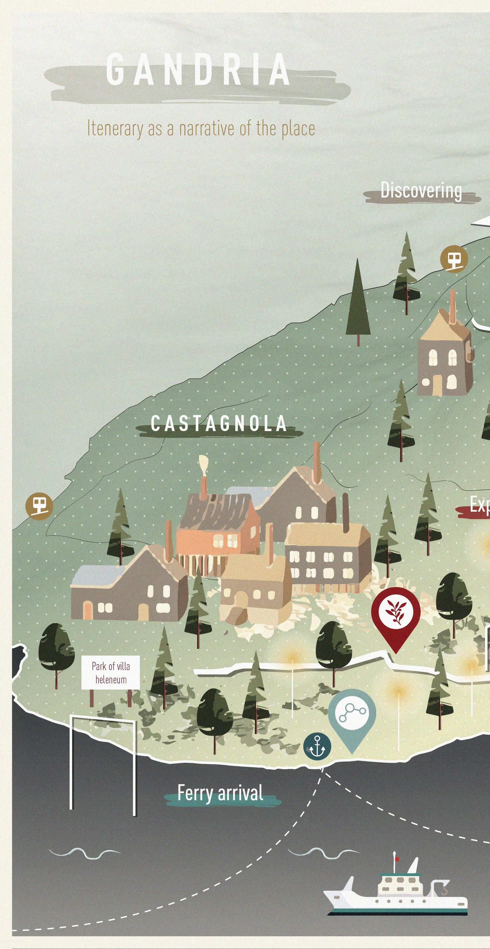
GANDRIA’S MASTER PLAN
GANDRIA GENERAL SYSTEM
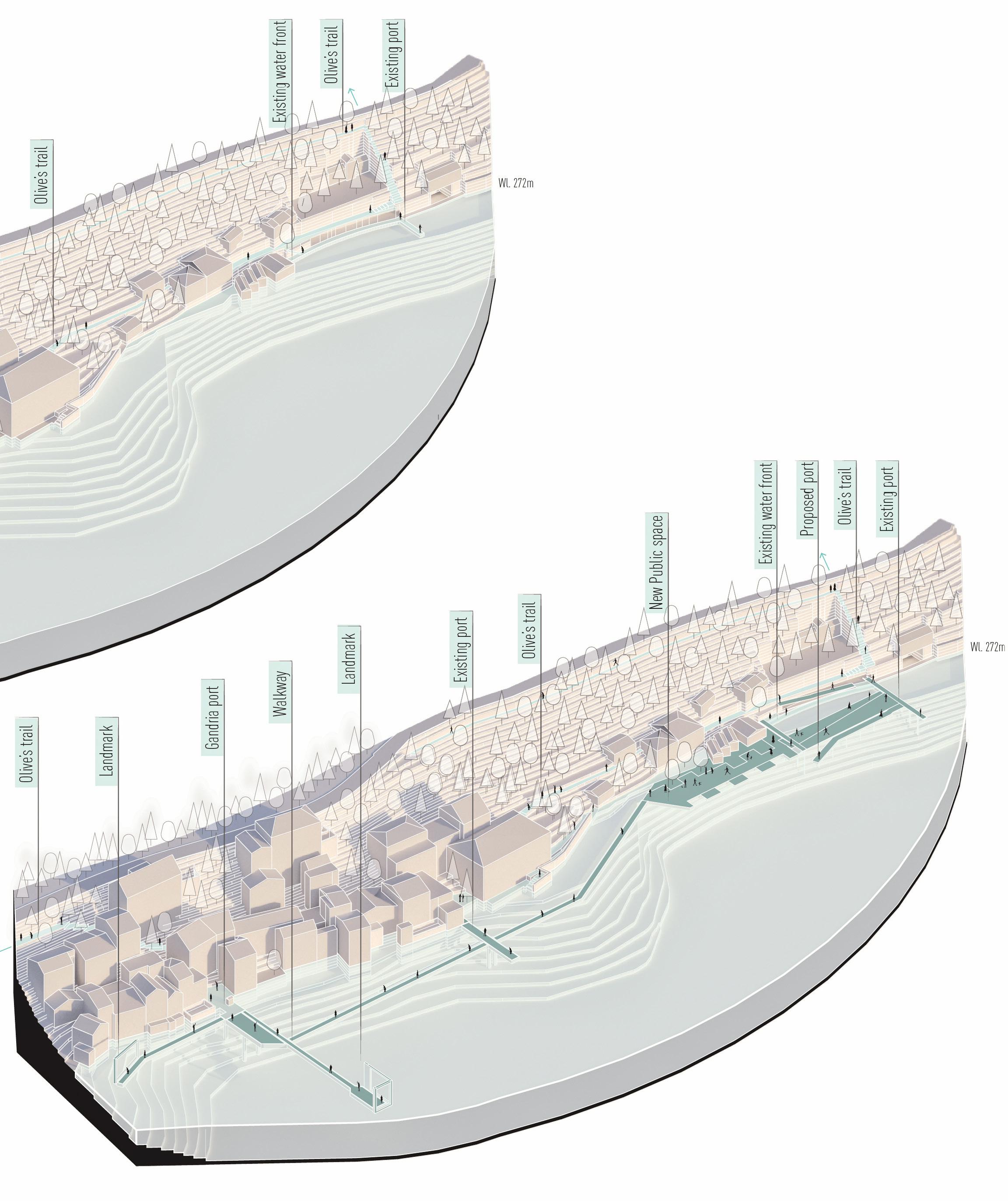
We identified three intervention points to develop in Gandria.The first intervention is located on Via Cantonale, in the upper part of Gandria, more precisely at the meeting of the Olive’s trail and the Brè Mountain hikking trail. This intervention consist of the improvement of the spatial quality of the road and the connection between both trails.

0 5.
The interventions two and three are located at Gandria’s waterfront, here the intervention aims to create a connection between the Olive’s Trail Itinerary and the Water Itinerary. This intervention consists in a series of public spaces, leisure areas, lookouts, harbours and water and vegetation spaces.


General system

LANDSCAPE AND INFRASTRUCTURE DESIGN STUDIO 2020 - 2021 GROUP / 21
INTERVENTION PROJECTS
GANDRIA’S MASTER PLAN
The architectural design and urban design were though to rescue the pedestrian space, the building tradition, the botanic values and the cultural heritage. The proposed projects seek to adapt to the different landscapes of Gandria, It emplacement was though in such a way to doesn’t fragment the landscape and doesn’t impose itself over it, on the contrary, want to be integrated into the existing landscape and highlight its values.

Intervention Intervention Point 1

0 6.
The vegetation design has the objective of stand up the different botanical landscapes of Gandria. The strategy is to stand out the two main landscape values of Gandria, the mountain and the lake. The design is focused in the improvement of the existing condition of the mountain ecosystem, a botanical value that currently is damaged and underrated, and the Lake bank ecosystem, a botanical value that has been lost along the years.

Projects
Intervention Point 2
Intervention Point 3
LANDSCAPE AND INFRASTRUCTURE DESIGN STUDIO 2020 - 2021 GROUP / 21
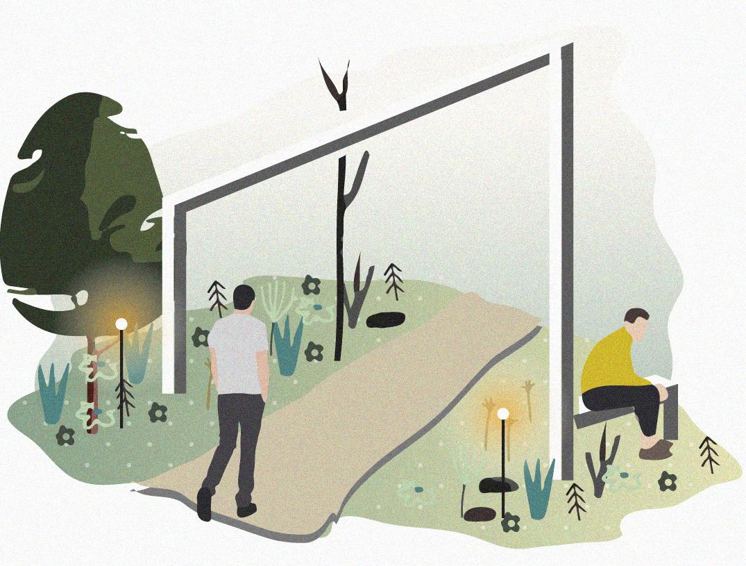
INTENVENTION POINT 1.
This intervention is focused in two main goals, the first one is to improve the existing connection between the Olive’s trail and the Brè Mountain trail, trying to create a continuity between both trails making them part of the same system. This first intervention also contemplates the location of an infrastructure which highlights the landscape values of this place while being a landmark that stands out the beginning or the end of the trails.
The second aim of the intervention its to rescue the surroundings of Via Cantonale, and to recover the space for people by implementing a shared street. This strategy plans to reduce the space available for cars in order to give more space for people, vegetation and bicycles.

Current situation
0 6.1
Intentions


LANDSCAPE AND INFRASTRUCTURE DESIGN STUDIO 2020 - 2021 GROUP / 21
GENERAL INTERVENTION
VIA CANTONALE & UNION OF ITINERARIES
The intervention consists of two parts, the sharedstreet public space and the lookout and connection between itineraries.
The shared-street intervention is proposed as a platform where car parking, bici-parking, vegetation and leisure and passing areas for people are implemented spatially together.
In order to create a mixture of activities, the design aims to create a constant relation between all users. There are two modules which structure the spatial division of the shared space, one of car parking that have three parking spots, and the other is a public space, which consists of bici-parking, a central garden and a leisure area toward the landscape. These two spatial modules are interspersed among them creating the desired mixture of activities. The last element is a walkway that redirects the Via Cantonale sidewalk to the edge of the platform, joining all the spatial modules and taking people to admire the outside landscape.
General plan 1:500

0 6.1
0m 30m 10m 20m

LANDSCAPE AND INFRASTRUCTURE DESIGN STUDIO 2020 - 2021 GROUP / 21
MAIN INTERVENTION

OLIVE’S TRAIL - MOUNT BRÈ TRAIL JOIN POINT
The improvement of the connection of both trails is proposed like an integral intervention that includes the direct connection of the trails and implementation of public space with a landmark that stand out the landscape values.


The connection of both trails is proposed as a stair, that gives the possibility to people to admire the landscape in different highs and directions while going down, this thanks to the balconies located in the landings of the stairs.
The public space and the landmark, is proposed as a Lookout, a place to frame Lugano’s lake canyon and the southern swiss alps. The lookout becomes then a place to stay, contemplates and admire, an infrastructure that stands out in the near landscape while standing out the distant landscape.
Localization Lookout plan 1:200 Facade 0m 100m 50m 0m 9m 3m 6m


LANDSCAPE AND INFRASTRUCTURE DESIGN STUDIO 2020 - 2021 GROUP / 21
PLATFORM FOR SHARED STREET VIA CANTONALE PUBLIC SPACE
The structure was designed in a metallic structure system, since it provides three essential characteristics for the project conception.
1. Resistance and firmness: the structure allows us to have both, heavy and light uses in the same structure without distinguishing different structural elements or systems.
2. Versatility: Being the platform a large linear element, the structure needs to have the capacity to easily adapt to the topographic variation.
3. Aesthetic values: this type of structure has the possibility to provide great resistance and firmness with light elements, this allows us to have minimal impacts in the landscape and the ground. The structure, even being a heavy and solid infrastructure, don’t have a strong visual impact in the landscape and have minimal impact on the ground.
A B C D E
Public space N:0.00
Constructive details 1:75 0m 3m 1m 2m
LANDSCAPE AND INFRASTRUCTURE DESIGN STUDIO 2020 - 2021 GROUP / 21 A 1 2 B C D F A A' B B' Public space N:0.00 2 1 Public space N:0.00
The structural system for this intervention was designed as two independent structures. On one side, the stairs were designed in a metallic structure continuing with the system of the shared-street platform.
On the other side, the public space and lookout structure is based in a retaining wall, recovering Gandria’s building tradition, but being developed in a new and modern way, easier to build but with the same resistance. This wall is proposed in stone elements that its geometry and the tongue and groove colocation of the elements allows the structural system to have very good resistance, the possibility to cover great highs and a very natural finish with simple elements.
This type of retaining wall is cheap, very simple to install, have minium damages in the ground, and all of this fully complying with the technical and structural requirements.
OLIVE’S TRAIL - MOUNT BRÈ TRAIL JOIN POINT Constructive detail 1:75 0m 3m 1m 2m
LANDSCAPE AND INFRASTRUCTURE DESIGN STUDIO 2020 - 2021 GROUP / 21
 Proposed lookout frame and panoramic stairs

LANDSCAPE AND INFRASTRUCTURE DESIGN STUDIO 2020 - 2021 GROUP / 21
INTENVENTION POINT 2-3.
Gandria’s waterfront and the Olive’s tree path are perceived as an open museum that can be seen from and in the water and also highlights this element of the landscape by inviting people who visit the place to walk on the water.

This area is then the point of arrival and point of connection between the two itineraries, where a connection is generated with the water and with the existing paths that take us to Gandria.
We want to improve the existing waterfront and port infrastructure which are yet very simple an narrow.
By introducing some Landmarks to mark these encounters between the two proposed itineraries, we want to improve and provide a new difuse public space for the enjoyment and appreciation of the landscape of the water through them. Current situation
0 6.2
Intentions
LANDSCAPE AND INFRASTRUCTURE DESIGN STUDIO 2020 - 2021 GROUP / 21
GENERAL INTERVENTION GANDRIA’S WATERFRONT
The general intervention is related to the water itinerary in which we want to highlight the historical and botanical value by improving the connection between the two trails: The porposed water walkways and the existing Olive’s path.
We want to enhance this area which is the main access from the lake, and because of its great natural value related to vegetation and water. This is the point of arrival the “door” of those who “enter” and also the point of physical connections, so called “the threshold” between Gandria and the rest of the city.
We identified this wasted zone at the lake level which serves as a natural bridge for native species and human activities. We want to be prepare for massive tourism but also to promote local activities making this place a space for living.
Thats why we want to recover the coast-line with a system of docks creating a new water front composed by two pricipal interventions. One is the new harbor and public space in front of the cemetery, and the other is a more diffuse intervention with floating walkways along the lake front of Gandria. General

0m 30m 10m 20m
plan 1:750

LANDSCAPE AND INFRASTRUCTURE DESIGN STUDIO 2020 - 2021 GROUP / 21
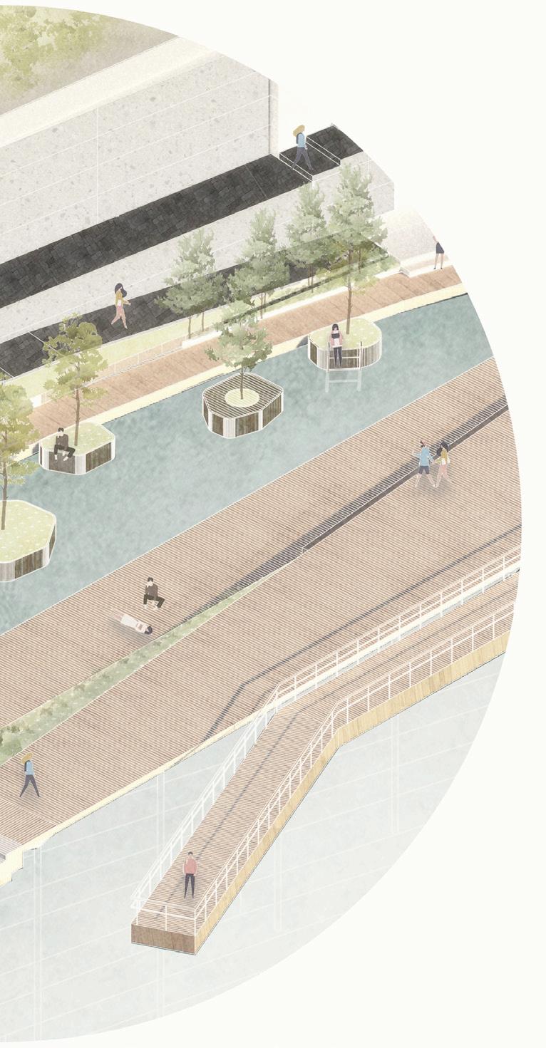
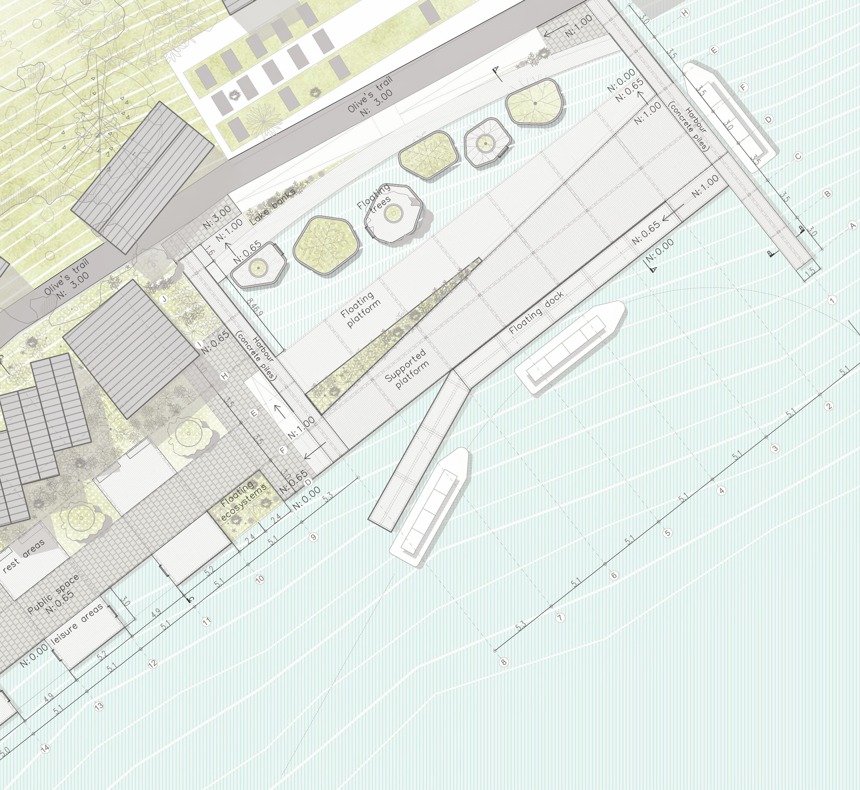
INTERVENTION POINT 2
GANDRIA’S NEW HARBOR AND PUBLIC SPACE


The new Gandria’s harbor is located in front of the existing cemetery being the connection point between the olives path and the proposed walkways which we call water itinerary.
We chose this potential point since it has the necessary space for the development of all the services and port facilities necessary for people and ships. By improving the existing infrastructure, we want to recover this beautiful place and its native vegetation.
We are proposing both a port infrastructure but also a new public space for locals and tourists. The intervention is made up of two types of docks, one supported by piles for the arrival of large ships and the other ones with a floating system for smaller boats and people. There are also some platforms that serve as leisure areas where people can develop different activities such as reading, relaxing and sunbathing. In the water voids we propose a system of modular docks, where people can enter the water to swim arround or climb on them.
Localization
Harbour plan 1:200 Facade 0m 100m 50m 0m 9m 3m 6m

LANDSCAPE AND INFRASTRUCTURE DESIGN STUDIO 2020 - 2021 GROUP / 21

detail 1:75 0m 3m 1m 2m
PORT STRUCTURE SYSTEMS Constructive

LANDSCAPE AND INFRASTRUCTURE DESIGN STUDIO 2020 - 2021 GROUP / 21

PUBLIC SPACE STRUCTURAL SYSTEM Constructive detail 1:75 0m 3m 1m 2m

LANDSCAPE AND INFRASTRUCTURE DESIGN STUDIO 2020 - 2021 GROUP / 21
 Proposed waterfront and vegetation

LANDSCAPE AND INFRASTRUCTURE DESIGN STUDIO 2020 - 2021 GROUP / 21
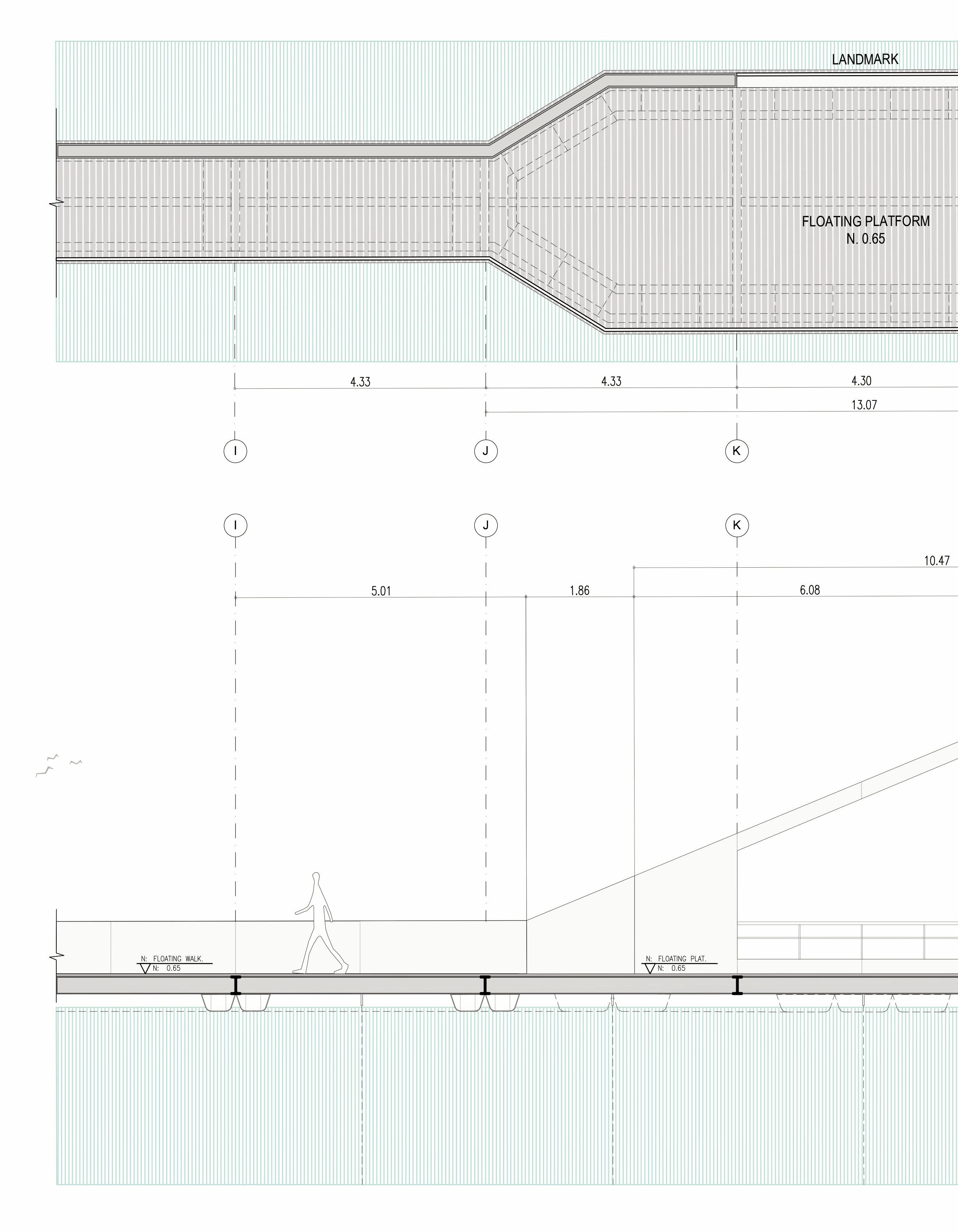
INTERVENTION POINT 3
PORT SYSTEM
In this part of our intervention, the Olive’s trail meets the water itinerary and we want to materialize this experience. Taking distance from the port, we can frame Gandria and the olive tree path as a postcard of the place also bringing the attention to visitors to areas such as the San Virgilio church.

The purpose of this intervention is to create through a system of ports that serve as structuring agents to generate a kind of walkways in the water that allow us to visualize Gandria by means of landmarks.

In this area two systems are used to support the platforms and the walkways, the first system is a platform that serves as support, and the second one is a floating system for the surfaces from the coast.

0 6.2
Localization Port system plan 1:200 Facade 0m 100m 50m 0m 9m 3m 6m


LANDSCAPE AND INFRASTRUCTURE DESIGN STUDIO 2020 - 2021 GROUP / 21
1:75 0m 3m 1m 2m
FLOATING DOCK SYSTEM Constructive detail


LANDSCAPE AND INFRASTRUCTURE DESIGN STUDIO 2020 - 2021 GROUP / 21
Floating islands and walkways


LANDSCAPE AND INFRASTRUCTURE DESIGN STUDIO 2020 - 2021 GROUP / 21
0 7.
Pedestrian infrastructure elements


connectivity elements of the system
Stairs Floating
The floating system docks and a metal the landmark, which not have any structural simply bent metal
The stairs are floating stairs, supported by a central metal beam allowing versatility and structural lightness, It can have two types of railing, solid or metal profiles, and two floor materials, stone or metal grid. Constructive detail 1:25 Constructive detail 1:25 0m 45cm 15cm 30cm 0m 45cm 15cm 30cm
Floating docks

system works with floating metal structure that supports which in this context does structural function, they are metal sheets.
Piles supported docks
The main ports have a structural system supported on concrete piles. These structure will receive the largest ferries and will work as an anchor for the floating docks.

LANDSCAPE AND INFRASTRUCTURE DESIGN STUDIO 2020 - 2021 GROUP / 21
Constructive detail 1:25 0m 45cm 15cm 30cm
Urban furniture elements
Isolated lights
In the extended surfaces of the public space is proposed a floor lighting system. This type of lighting provides a faint light and allows the continuity of the public space without physical interruptions.

Railing lights
The lighting furniture is designed like thin metal profiles that can be located along the paths in an isolated way but also can be integrated elements into the railing structures in the walkways, ports and stairs.

Bollards
These elements allow having continuous surfaces and differentiated areas. The elements are proposed to separate the heavy traffic areas and the areas of the public space, maintaining the surface continuity.
Bike-parking

The bike-parking element is the same bollard element but bigger. Some of the bollards and bikeparking elements also function like lighting elements, complementation the illumination of some areas.

0 7.
Port benches
The urban benches of the docks were designed in such a way that has a tectonic and geometric continuity with the floor. Therefore the benches are elements which are an integral part of the design.
Floating islands
This system of floating docks are containers that allow vegetation float in the water.

Isolated benches
The benches located at surfaces like concrete or stone has the same principle of geometrical continuity, but unlike the benches of the port, seek to stand out from the surface by having a material change at the top.

Tree grate
The metal tree grills are located in the public space and have the same materiality as the frames, here olive trees are planted to keep it as a cultural and natural symbol of Gandria.


LANDSCAPE AND INFRASTRUCTURE DESIGN STUDIO 2020 - 2021 GROUP / 21
0 8. VEGETATION SYSTEM
PROPOSED VEGETATION AND LANDSCAPES
What we want to achieve with our interventions is the generation of new public spaces full of activities and where the vegetation takes the protagonism.
In Gandria we found that there are still some green areas along the lake-coast and we want to extend them into the new public spaces, recreating a natural “lake banks”.
Morover, there is a productive and naturalistic interest related to the Olives tree, which represents a source of income for the city. We want to give it back the importance, as a symbol, introducing it among the interventions.

We also want to improve the existing vegetation by introducing species that we can find around Gandria, the Olive;s trail and Mont Bré. We selected species that can grow in warm areas, in walls and on sunny rocks, and others that can float.
We are proposing tree types of green areas related to the mountain, the lake banks and the water. By creating these spontaneous and native gardens, as mentioned by Gilles Clément in his book of “The Third Landscape”, we want to improve biodiversity and return the botanical value to the place.

LANDSCAPE AND INFRASTRUCTURE DESIGN STUDIO 2020 - 2021 GROUP / 21
0 8. VEGETATION SYSTEM
WATER SPECIES AND PROPOSED LANDSCAPES
In the space between Gandria and the proposed walkways, we found water spaces that can be used to improve the vegetation that will be part of the water itinerary. For this, we look for different systems that help to generate different atmospheres and that can work in different seasons of the year, thus becoming one of the many attractions that Gandria can have with our intervention.
Systems such as floating islands, floating trees that would help to highlight the botanical and cultural value of the olive tree in this itinerary, or be able to highlight the existing vegetation with a kind of ¨Lakebanks¨ and finally, the other interesting option is Floating Ecosystem Modules because they have multiple benefits including habitat creation, urban waterscaping, water quality management and wastewater treatment

 01. Floating aislands
03. Floating ecosystems
01. Floating aislands
03. Floating ecosystems


LANDSCAPE AND INFRASTRUCTURE DESIGN STUDIO 2020 - 2021 GROUP / 21
02. Floating trees
02. Lake banks

