Lambton Musings

www.heritagelambton.ca

www.heritagelambton.ca
Fiona Doherty, Moore Museum
Stewart James was introduced to magic at a very young age. As a tinsmith, his father was asked to make small contraptions for magicians from time to time. His grandfather, a more willing contributor, had completed far more of these projects. Neither Stewart’s mother nor father were supportive of his interest in magic. Stewart’s father would open the mail when a parcel came for him, not wanting his son to perform a trick that he didn’t himself understand. But Stewart would soon modify the tricks that he purchased and upset his father.
At his home
“Aberystwyth” in Courtright, Stewart was often confined to the house and the small veranda outside his bedroom. His mother believed him to be unwell and liked to keep him close to home. Stewart only attended school from the ages of seven to fifteen; however, this lack of schooling would not inhibit his ability to understand and create complex magic tricks. Magic was a distraction from his solitude, and he retreated into his practice with Stewart James

imaginary friends. It did not take long for Stewart’s talent to flourish, and he first performed at Stewart Hall in Courtright at age nine.
In 1915, Stewart learned a trick called “The Knot of Enchantment”, a rope trick where a magician makes a knot appear in the middle of a rope tied to his wrists at both ends. This trick sparked his interest in the principles of magic and not just tricks. In this case, understanding these principles allows the magician to create the knot using physics and not the sleight of hand.
The first trick Stewart published was “A Match for Gravity” where the magician tied two objects to the ends of a string: a match at one end, and a delicate or expensive item borrowed from the audience at the other. Holding on to the match, he draped the string over a pencil, then let go of the match. Instead of falling to the ground, the delicate object would be suspended in the air, the match having wrapped itself around the pencil and secured itself into place. This was the beginning of Stewart James’ contributions to magic books and magazines. It highlights his focus on principles and physics, and this trick was adapted and performed by many magicians. While Stewart is recognized as a skilled magician, he is best known for his ability to create. Publishing his works connected him to the magic community. It was liberating and rebellious, as his parents still discouraged his pursuit of magic.

International Brotherhood of Magicians Certificate
Stewart spent a lot of time with a deck of cards. Small and portable, this was the perfect tool for covert practice and invention. “Spell of Mystery” was released in 1929, and Stewart described it as his first trick to go into the world, while he himself was still tightly tied to his home. Stewart retreated into a hidden utopia in his imagination, a paradise where he was able to meditate on tricks and methods. This led him to discover new principles, and an effect he marketed as “Miraskill”, what has now become a classic card effect and possibly Stewart’s most famous work.
Stewart was also well known for his predictions. In 1938, a promoter for a magic convention in New York told the press that Stewart James was a psychic and would predict the headline of a particular newspaper one year in advance. While reluctant, Stewart agreed and his prediction was sealed in an envelope, secured in a metal chest and kept at a police station. One year later, Stewart was sequestered in a hotel room as the chest was brought out and a stage was set. His prediction was almost perfect: “World War Threatened, Germany Attacks Poland”. The newspaper had used “Nazis” in place of Germany.
After predicting the war, Stewart enlisted in the Canadian armed forces. He initially worked on codes and cyphers but was transferred to a touring theater troupe providing much needed entertainment to the forces across central Europe.
When he returned after the war, he began to care for his aging mother. His father had passed away, and sisters had married and moved on. He delivered mail for the local post office and operated a small store with magic supplies. He continued to develop ideas and principles, often with help from “The Board,” a group consisting of Rigonally, Faxton and Kardova. These three board members were imaginary friends, the same ones who had been with young Stewart in his early and solitary years.
Stewart James was a prolific inventor, well respected by his community and still revered long after his death in 1996. His accomplishments were recorded in several books. These trade secrets are only available to members of the International Brotherhood of Magicians, but you can see his legacy in the hundreds of tricks adapted and performed by magicians to this day.
Nestled in the corner of Gum Bed Line and Kelly Road, a modest green building silently narrates a tale of resourcefulness and tenacity that defined the twentieth century Oil Springs oil producers. Until the mid-1970s, the railway was the main artery for the transportation of oil across Ontario. Receiving stations were crucial hubs where oil producers’ efforts were carefully documented. This is where the oil was tested, and the producer received an oil ticket or receipt that was checked at the bank, and they were be paid for their product. In Oil Springs, producers loaded up their tanker wagons, which could carry 8 barrels or 2½ tons of crude oil, and dropped it off at underground storage tanks located at the receiving station. A sample was taken and left overnight to allow water and sediment to settle, and this percentage was removed from the overall weight of the shipment.
The inception of the Kelly Road receiving station came about in 1915, an initiative by Imperial Oil and oil producers on a parcel of land donated by the Fairbank family. This strategic move aimed to provide a new market avenue for producers in Central Lambton, countering the grip that Canadian Oil Producing and Refining had over oil transportation in Lambton County. Enthusiasm sparked the need for a loading rack on the north side of Oil Springs, prompting the producers to petition the New York Central Railway. Once opened, the station’s daily operations commenced under Mr. Lamey and Charles Smith, who became the very first commuters in Oil Springs. In 1917, the station was closed due to limited usage with most producers still using the Canadian Oil Producing and Receiving station.

The receiving station
However, in 1923, the receiving station was re-opened, rejuvenated by unanimous support from local producers who favored it over Canadian Oil. Before its reopening, the station was upgraded, transitioning from a steam boiler to an electric supply, using the Ontario HydroElectric Power Commission’s lines that had finally reached Oil Springs. A pivotal figure in this story is Byron A. Evoy, who served as a receiver and pump man for the Imperial Oil station from 1917 to 1933. After he retired, the torch was passed to his son, Tom Evoy, who continued the station’s operation under Imperial Oil until 1955.
The future of the station was again in question when, in 1955, Imperial Oil shut down its receiving stations in Lambton County. Through negotiations, control of the receiving station transitioned to local producers, with Imperial Oil contributing $100 monthly for maintenance. Now under the stewardship of the Oil Springs Petroleum Association, the station continued servicing the area. The capable hands of industry veterans Henry Wheeler, Samuel Donald, and supervisor of the association, Charles O. Fairbank, guided the station’s activities. Yet, the station’s timeline took another twist. Influenced by New York Central Railway’s decision to cease service to Lambton Country and the preference for tanker trucks to transport oil directly from the producer’s land, the Imperial Oil receiving station closed its doors for a final time in 1973, marking the end of an era.
Over its 52-year lifespan, the station facilitated the movement of around 2,600 barrels of oil each month. Today, this unassuming building stands as a testament to the grit and determination that characterized the journey of crude oil from its source in Oil Springs to its markets. Tom Envoy summarized the importance of the receiving station, “The building brings back memories of the days when crude oil found its way to markets through the muck and mire of Enniskillen Township clay roads.” With each creak of its timeworn walls, the memories of those days are rekindled, immortalizing the station’s place in the vibrant history of Oil Springs.
In 1985, Charlie Fairbank III petitioned the Township of Enniskillen to designate the station as a property of architectural and historical value. This sparked a transformation that breathed new life into the long-forgotten structure. The station is now one of many stops on the Oil Museum of Canada’s audio driving tour which takes guests on a journey around an Oil Springs historic oil field. A true highlight of this tour is the incorporation of metal sculptures, meticulously crafted by artist and blacksmith, Murry Watson. The sculptures pay homage to past Fairbank employees and individuals from the Village, etching their memory into the landscape. Murry grew up in Oil Springs, his father and grandfather owned Watson’s Machine Shop which was purchased in 1946. The sculptures are made of welded sheet metal and took up to two months to complete.
Outside of the station next to an underground storage tank is an oil wagon being pulled by a pair of Murry’s metal horses. Atop the wagon a tribute to Samuel Donald portrays him collecting an oil sample for overnight analysis. Stepping inside the station, the scene continues to unfold with Tom Envy extending a warm welcome to visiting oil producers. To his left, creating a receipt for their product is Henry Wheeler. Come on down to the Oil Museum of Canada to see the receiving station firsthand and experience the amazing artwork of Murry Watson.

The receiving station
Glenn Stott, Arkona Lions Museum
If you were educated in the public school system in Ontario more than a decade or so ago, you probably learned that the Iroquois Five Nations or Haudenosaunee Confederacy waged war on the Huron (Wendat), Petun, and Attawandaron Nations in the mid-1600s, driving them away and destroying their villages, leaving southwestern Ontario for their own use and possession. Most history courses went no further other than identifying the considerable roles the Indigenous people played in the Seven Years War, the American War of Independence, and the War of 18121814, often from a colonial perspective and nothing related to the occupation of Southwestern Ontario.
As an Euro-Canadian educator, I was puzzled by the presence of the Anishinaabeg in Southwestern Ontario. According to my studies, the Anishinaabeg were from Northern Ontario and not the Haudenosaunee, except for the Six Nations Reserve in Brantford, which they received as compensation for the loss of traditional territories lost to them during the American Revolution. There seemed to be no explanation.
Canada’s Indigenous people have rich oral histories that have been preserved over the millennia by elders. Settler Canadian historians and educators have belatedly learned the value of these ancient histories. For instance, archaeologists located the wrecks of Sir John Franklin’s Erebus and Terror ships after they finally began consulting the oral traditions of the Inuit. Archaeologists found the Inuit histories contained vital clues to the actual location of these wrecks. The sites have been identified and are now a historical treasure.
In the 1970s, the University of Dayton’s Leroy Eid began researching the oral history of the Ojibway as recorded by George Copway in his Traditional History of the Ojibway... and others including Robert and Johnson Paudas and William Warren. Eid determined that between 1652 and 1701 there were a series of conflicts between the Ojibway nations in the north and the Five nations in the south over the fur trading routes. This led to the Ojibway forming the Council of the Three Fires among the Ojibway, Pottawamie, and Chippewa to combat the ongoing aggression of the Five Nations. Over the ensuing decades various treaties between the warring nations failed when members of the Five Nations broke these agreements and attacked Ojibway trading groups and settlements.
In the 1690s, the Council of Three Fires decided enough was enough and organized a massive attack on the Haudenosaunee settlements (Five Nations) located in what is now Southern Ontario on former lands of the Huron and Attawandaron. The Council sent 400 birchbark war canoes (5.5 m or 18’ long), each carrying eight warriors, to attack their common enemy. They chose a three-pronged attack from the modern day Sault Ste. Marie area, along the Severn River to Lake Simcoe, to the Ottawa River to Lake Ontario, the west coast of Lake Huron to Lake St. Clair, and the French River to Lake Nipissing and the Peterborough area. The result was a complete defeat and destruction of all Five Nations hunting parties, settlements and war parties in the Southern Ontario region. The Ojibway canoes outmanoeuvred the Five Nations heavier elm-bark canoes as many of the battles were fought on the water including Lake St. Clair, Saugeen River, Severn River, Rice Lake, and into the Toronto area. Closer to the Lambton area there was a battle on Lake St. Clair and one on the Thames River. As reported by the Boy Scouts of Canada’s Camp Attawandaron in Lambton Shores, there were also battles on Lake Huron.
The result of these strategic victories was a complete withdrawal of the Haudenosaunee from Southwestern Ontario and a fundamental change to the balance of power. As a result of this rout the Five Nations Council approached the colonial French at Quebec, with whom they had been in frequent conflict, pleading the establishment of a fort at Detroit in 1701 to ensure that the Council of the Three Fires would not continue to attack the Haudenosaunee homeland in what we would now call New York State.
These histories have shed much light on the ongoing complexity and richness of the history of Southern Ontario and the important impact and role of the Anishinaabeg. Oral histories filled in important details about a period traditionally ignored or overlooked in settler Canadian histories. Today, these events have been recorded by historian Leroy Eid, but also by Peter Schmalz and David Plain.
There is a display case at the Arkona Lions Museum at Rock Glen Conservation Area, Arkona, dedicated to this event.
For further reading:
Copway, George, The Traditional History and Characteristic Sketches of the Ojibway Nation, Toronto, Coles Reprint, 1972.
Eid, Leroy V. “The Ojibwa-Iroquois War: The War The Five Nations Did Not Win”, Ethnohistory 26/4 (Fall, 1979).
Plain, David D, The Plains of Aamjiwnaang: Our History, Toronto?, Trafford, 2007.
Plain, David D, From Ouisconsin to Caughnawaga, Toronto, Trafford, 2013.
Schmulz, Peter, The Ojibwa of Southern Ontario, University of Toronto, Toronto, 1991.
David McLean of The Forest Museum
Artifacts can tell many stories of the past, covering the breadth of human experience. These stories may be enlightening, entertaining and even uplifting. The focus of this article, however, is an artifact associated with great tragedy and suffering.
The device came into our possession earlier this year, a donation from the family of Anny Michielsens (1934-2023). Anny, a keen supporter of our museum, passed away last October. To honour her memory, her family donated proceeds from her estate sale, run by our museum volunteers, to our museum. The Michelsens family, consisting of Anny, her brother Willy, and their parents Walterus and Maria, emigrated from Belgium in 1952 and settled on what is now Goosemarsh Line. They cleared the land and built their homestead and farm.
When Anny’s family first made me aware of the unusual object she had left behind they referred to it as “part of a bomb”. Prior to seeing it, my initial thought of, “Oh no, perhaps we will need to call in a bomb squad” was soon followed by a guess that the item was a harmless shell casing, of which we already have a few in our collection. A few days later, I drove out to the Michielsens’ property to prepare for the estate sale. While I was there, I asked to see the war relic. Much to my surprise, I was shown a device with a propeller, something I could not immediately identify but which was obviously meant to be airborne. Then I thought, “Oh no, it can’t be what I think it is... a component of a German flying bomb!” Sure enough, after further investigation and research I came to the conclusion that it was indeed part of a Second World War V-1 rocket, its guidance system to be exact. A shiver went up my spine when I made this discovery.
V-1 stands for Vergeltungswaffe 1, which translates from German as “Vengeance Weapon 1”. Over 9,000 of these rockets were launched against Britain beginning on June 13, 1944, a week after D-Day. As the Allied forces pushed northward from Normandy, France into Belgium, the Germans began firing V-1 and then V-2 rockets at targets in France and Belgium. All told, some 18,000 people were killed by these new weapons of war. Compounding the horror of their usage, it must be remembered that the V-1 and V-2 rockets were built using the forced labour of an estimated 60,000 prisoners, including Jews and other enslaved peoples. Twenty thousand of these prisoners died due to their miserable working conditions.
So what exactly is the object donated to us by the Michielsens? It is a vane anemometer. Without going into too much detail, it was a device secured in the nose of a V-1 bomb. As the bomb flew through the air, powered by its jet engine, the airflow turned the propeller, which in turn drove an odometer that counted backwards from a value corresponding to the distance to the target. The odometer eventually clicked down to zero, causing the steering system to force the V-1 into a steep dive toward the target.

How the anemometer came into the possession of the Michielsens isn’t entirely clear, but a clue as to the V-1 bomb it once belonged to is found on a cardboard cylinder surrounding the shaft of the device. Written on this cylinder is the date January 23, 1945. I made a guess that someone wrote the date on the anemometer to indicate when the V-1 had impacted its target. I scoured the internet for any record of a V-1 being fired on that date in Belgium and, much to my surprise, soon found a website that gave me an answer. Maintained by Belgian historian Peter Serrien, the website documents every known strike by V-1 and V-2 rockets during the war. His database provides a record of when and where each of these strikes occurred. According to the database, at around 2:45 a.m. on January 23, 1945, a V-1 flying bomb was shot down over the rural residential area of Dorent in the municipality of Burst, a place midway between Brussels and Ghent. It was the only V-1 launched against Belgium that day.
Peter Serrien’s website goes beyond just providing details as to when and where the rockets struck. It also provides access to relevant contemporary documents. For the one that fell on Dorent there is an official report written up by the local police that states:
“A V-1 flying bomb was shot down to explode [and fell into] the courtyard/garden and a dozen metres from two adjacent residences…. One victim has died and another 5 have been nonfatally injured…. Two residences have been totally destroyed and several other residences and their contents have been damaged…. The hole caused by the explosion of the device has a diameter of 5 metres and a depth of 2.5 metres.”

The young woman killed by the bomb was 18-year-old Maria De Meerleer. She was probably sleeping when the bomb struck, destroying her family’s home and seriously injuring her mother. Who retrieved the anemometer and how it came into possession of the Michielsens is a story that I may never be able to fully piece together, but I have been in correspondence with Peter Serrien regarding it. He no longer conducts research on the V-weapons, but has offered to connect me with the state archives in Antwerp to see if they might be of assistance. Someday we may repatriate the device to Belgium, but for now it will be safely kept at our museum, along with signage in memory of Maria De Meerleer.

Dana Thorne, Lambton Heritage Museum
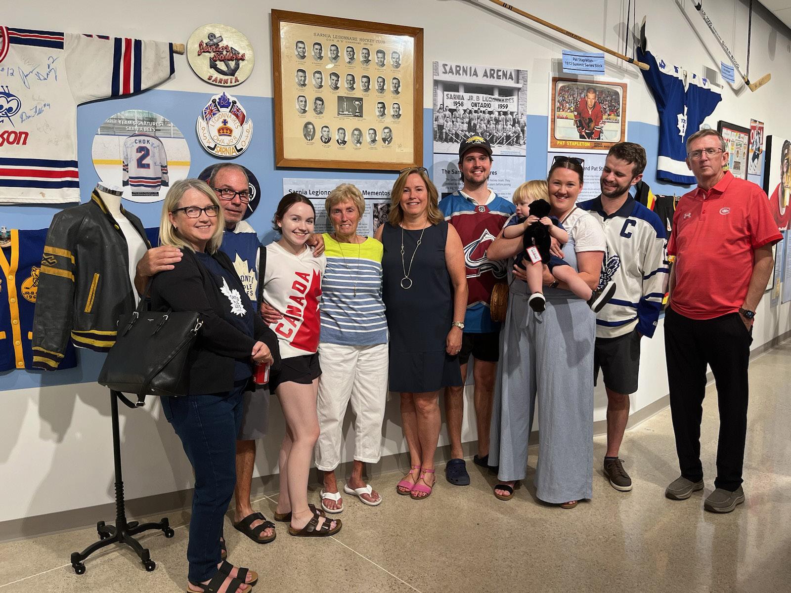
Join us at Lambton Heritage Museum before November 9 for our special feature exhibit, Hockey. Get ready to dive deep into the heart and soul of Canada’s favorite pastime! The sweat-soaked smell of the locker room. The flick of the wrist-shot. The scream of the enthusiastic fans. Hockey isn’t just a game; it’s woven into the very fabric of Canadian culture. It unites us, thrills us, and defines us. This one-of-a-kind travelling exhibition from the Canadian Museum of History offers visitors an exciting interactive experience showcasing high points in the sport from both yesterday and today. This engaging exhibition explores the importance and influence of hockey over the past 100 years, and brings the history of the sport to life through profiles of participants at both the professional and amateur levels.
But that’s not all! Lambton Heritage Museum has curated a special addition to the exhibit. Explore local artifacts and hear stories with deep ties to Lambton County. These treasures offer a glimpse into how hockey has shaped and influenced our own community, providing a richer understanding of its significance on a local level.
Many of the individuals who loaned items to the Museum for this exhibition have stopped by to see the displays. Explore some of their stories with us in this article.

Ira Downer was the manager of the Petrolia Gibbons-Squires during their Allan Cup championships in 1979 and 1981. He loaned us items including a team jersey, framed team picture, hat, mug, badges, pins, plaque, and more.
Downer kept scrapbooks documenting the team’s history, including telegrams sent to his hotel in Thunder Bay during the 1981 Allan Cup series. These telegrams came from Petrolia and Lambton County businesses and residents wishing their team all the best. The telegrams were scanned and reprinted for display in the exhibition. One telegram from Uncle Tom and Pat said, “Beer tastes great from the Allan Cup... Bring It Home!”

The Sarnia Legionnaires hockey club are celebrating their 75th anniversary this hockey season and we’re pleased to feature this iconic local team in our Hockey exhibit. Lloyd Dicker and Jeff Percival from the Legionnaires Board of Directors stopped by to check out the displays. The team was generous to lend some of the items they usually have on display at Pat Stapleton Arena to our Museum for this feature exhibition.
Stan Ulrich is a familiar face in local hockey circles. During over 90 years in our community, he has had a big impact on the game as a coach and a player. Ulrich played in exhibition games with the Detroit Red Wings in Forest in the 1950s. In those days, professional players participated in these “barnstorming” exhibition games in small communities. They drove themselves to Forest from Detroit in the middle of the regular season to play! Legendary Red Wings at that game included Gordie Howe, Terry Sawchuk, and Marty Pavelich.
John McIntyre
One theme we explore in our Hockey exhibit is players that grew up playing in Lambton County and were drafted into the NHL. John McIntyre learned to skate on his family farm near Ravenswood before playing in the NHL from 1989 to 1996. He played for the Toronto Maple Leafs, Los Angeles Kings, New York Rangers, and Vancouver Canucks.
He loaned us a framed Corn Flakes box that featured his 1993-1994 season with the Vancouver Canucks. His team was the Western Conference Champions that year, and almost achieved Stanley Cup glory before losing to the New York Rangers in Game 7.
Dick Robinson is a big name in the local hockey scene. Members of his family including his children Kelly Dann and Jeff Allen reviewed Robinson’s collection of local hockey memorabilia and provided many items for the exhibition.
Robinson played for the Sarnia Legionnaires during the 1950s alongside future NHL All-Star Pat Stapleton. He was also an influential minor hockey coach, leading teams with players that went on professional and semi-professional careers.


Meagan Sinclair, Lambton County Archives
While many of us are familiar with curbside pickup as a service popularized during the recent pandemic, some people remember it as a feature of many local restaurants about 50 years ago. One example is the Rendezvous Grill, a drive-in restaurant located at 759 Lakeshore Road on the corner of Lakeshore and Mallah Drive in Sarnia. A search through the directory collection at the Lambton County Archives shows that the Rendezvous Grill first opened around 1951. At the time, the proprietor was Alexander Brumaroff. The business was leased to John Wilson in 1956, and finally purchased by Wilson in 1958.

Some may remember a large fire at the establishment in 1963. An automatic french fryer caught fire in the restaurant’s kitchen and flames soon took over the interior of the building, including John Wilson’s upstairs apartment. The restaurant was reconstructed and an advertisement from 1978 shows that patrons could buy an order of fish for $1.75. The restaurant continued to operate until Wilson’s death in 1981.
Shifting over to Petrolia in 1972, Charles Whipp, owner of the Petrolia Advertiser-Topic, was moving his printing business to a new location on Albany Street, under the direction of contractor George Shabsove. The newspaper would occupy only half of the building, so Whipp asked Shabsove to go into business with him to develop the other half of the building. When deciding what kind of business to start, they considered what was needed in the community and decided on a large, family-style restaurant.
Construction quickly began on the 200-seat restaurant and banquet hall. Tony Isber, owner of Tony’s restaurant which had operated in Petrolia for 34 years, was hired to manage the new restaurant, and a team from Fanshawe College was engaged for the interior design.
The owners wanted the new restaurant to recall some of Petrolia’s great historical moments relating to the discovery of oil, so they named it The Oil Rig and chose décor which reflected the oil history. Local artist Rick Garner painted a 45-foot mural of scenes from early Petrolia. Decorative oil rigs were produced by local machinist Albert Baines to adorn the exterior lamps. The Oil Rig Tavern opened to the public on August 5, 1972.

Alan Campbell, Lambton County Branch of the Ontario Genealogical Society
My columns of late for Lambton Musings have tended to describe families in the former Plympton Township and former Enniskillen Township. To spread my research across Lambton County I accessed the Ontario Gazetteer and Business Directory 1884-5, available on www.ancestry.ca , and randomly selected the village of Shetland, Euphemia Township as a take off point.
The entry for Shetland was as follows:
“Shetland. A village on the Sydenham River (which furnishes power), in Euphemia Township, Lambton County, 40 miles south-east of Sarnia, the county seat, 8 north-west of Bothwell on the GW div GT Ry, the nearest railway and banking point. It contains a Methodist church and a public school, and ships grain and produce. Population, 100. Mail tri-weekly. R H Badgley, postmaster.
Badgley R H, General Store.
Graham, Joseph, live stock.
Healey Marshall, blacksmith
Liard R, shoemaker.
Moorhouse W H, carpenter.
Pesha A J, organ and sewing machines.
Powell, Johnston & Co., Saw Mill.
Reid Rev Charles (Methodist).
Stratton A H, saw and flour mills.”
A.J. Pesha, a purveyor of organs and sewing machines, caught my attention. What could I find about him in the records of the time? Continuing my search of gazetteers and directories, I found additional entries. In the Union Publishing Co.’s Farmers’ and Business Directory for the counties of Elgin, Essex, Kent & Lambton 1888 [www.canadiana.ca], Alfred was listed under Sewing Machine Agents and as operating in Shetland. The Ontario Gazetteer and Directory 1888-9 supplemented the above information by recording that he was the postmaster and was also selling groceries and dry goods. The Ontario Gazetteer and Directory 1892-93 captured him as Pesha, Alfred J. Shetland, under Piano and Organ Dealers [www.canadiana.ca].
The 1861 Census for Canada West, Township of Euphemia, captured Alfred J. age 3, with his

A.J. Pesha food storage crock,
parents Peter and Henrietta. As of the 1881 Canada Census, Euphemia Township, Alfred was still at home and recorded as a farmer. The 1891 Canada Census for West Middlesex captured Alfred born at Quebec and his wife Euphemia born at the Isle of Mann, England. Lest the West Middlesex suggest a move by Alfred and Euphemia, that is not so, as Sub District C was Euphemia Township. Boundaries were fluid in some of these census districts and crossed over county lines. By the 1901 Canada Census Alfred was living in the Township of Chatham, Kent County with his wife Euphemia and sons Stafford, age 6, and Bernard, age 4. He was recorded as a general merchant.
Charles Stafford Pesha, age 26, married Minerva Lois Smith, daughter of W. R. and Mary (Bresett) Smith, 6 December 1920 at the Louisville Methodist Parsonage, Louisville, Kent County [northeast of Chatham on Highway 2]. Alfred Bernard Pesha, age 30, married Velma Kate Gregory, daughter of daughter of Clifford and Clara (Bone) Gregory, 24 November 1927 at Louisville, Kent County, Ontario.

J.A. Williams Store 1902-09, Lambton County Archives collection
The Pesha family file at the Lambton County Archives provided more source information. A newspaper article, Kent County Couple Observe 50th Anniversary, in the Canadian [Chatham] 10 November 1937 recorded the information that “Mr. and Mrs. Pesha were married in the year 1887 at the farm home of Mrs. Pesha’s parents, the late Benjamin and Margaret Gelling Burdon in Euphemia township, Lambton County. Rev. Mr. Taylor then incumbent at Wardsville Anglican Church performed the ceremony.” The fact that the marriage was handled by an Anglican minister may be why a civil marriage registration has not been found to date. Transcriptions from the Bothwell Times newspaper filled in some of the family story [Pesha family file, LCA]:
30 April 1885
“A J Pesha of Shetland has been appointed agent for the Uxbridge Organ [Uxbridge Organ Co.] which has a guarantee for 5 years.”
22 October 1885
“Mr. A J Pesha of Shetland reports that he has met with unexpected success during the summer months in the sale of Sewing Machines not withstanding the dull times. At the fair in Florence he made 11 sales.”
30 December 1886
“Mr. A J Pesha of Shetland purchased Mr. Badgley’s general store at Shetland.”
5 October 1893
“Mr. A J Pesha has moved to Kentbridge where he is keep[ing] a general store having sold his stand here to Thos Risk formerly of Aberfeldy.”
Lambton Heritage Museum and the Lambton County Archives were able to provide tangible images related to A.J.’s time in Shetland. The image of the food storage crock labelled A.J. Pesha - General Merchant – Shetland is courtesy of Lambton Heritage Museum. The picture of J.A. Williams’ store at Shetland is courtesy of Lambton County Archives. J.A. Williams was the sixth owner of the property from 1902-1909 so the store may have had a different appearance to when A.J. Pesha owned it.
The Assessment Roll for the Township of Euphemia 1880 recorded Alfred on the north part of lot 23, concession 3 and holding two acres of cleared land valued at $20. He did not have to pay any assessment. His father, Peter, was close by on the south ½ of the west ½ of lot 23, concession 4. At the time that the Assessment Roll for Euphemia Township was taken for 1888, Alfred, a merchant, was a tenant of John Drew on part of the east part of lot 24, concession 24. He was renting one quarter of an acre.
No record is “sacred” as the Sixty-sixth Annual Report of the Missionary Society of the Methodist Church from June 1889 to June 1890 recorded that A.J. Pesha and his wife donated $2.00 via the Shetland Church to the Florence charge [www.canadiana.ca].
Euphemia died 10 June 1948 at Kent Bridge, Kent County. Alfred died 4 February 1953 at Broward General Hospital in Florida. His body was shipped back to Canada. Alfred and Euphemia “returned” to Shetland as they were buried in Shetland Cemetery. Their sons Charles Stafford and Bernard and daughters-in-law Minerva and Velma were also buried there in the family plot.


When colonial administrator Sir John Colborne took office, one of his priorities was to open up the western frontier of Upper Canada, creating a passageway to southern Lake Huron. This endeavour would involve cutting and clearing a swath of forest from the town of London to the southern extremities of Lake Huron. This opening up of the timberland is known today as the Egremont Road. Less than two decades earlier, the War of 1812 had taken place with the Americans. There were still sentiments of insecurity at the border and it was felt that a military influence and settlement would bolster and enhance border integrity.
The survey of 1829 was started under the direction of Charles Rankin, and completed in 1832 by Peter Carrol. After the survey was completed, then the clearing of forest commenced to allow for the building of the Egremont Road. The town plot of Erroll then started to develop a settlement of businesses and residents.
After a few years, Errol was an enterprising endeavour. It had two blacksmith shops, a post office, a school, a church, three magistrates, and two taverns. As time passed, it became evident that a reliable road to Port Sarnia was more favoured than the Egremont Road leading to Erroll. Port Sarnia at the time was in its infancy, sparsely settled, but had business interests and commerce presence. A reliable passageway from the town of London became necessary for business interests in Sarnia. This was a great contentious issue. A road directly from Warwick to Port Sarnia would bypass the then aspiring community of Erroll.
To aid in the development of a road to Sarnia, a petition was presented to the Legislative Assembly at Kingston Ontario. The petition of February 2, 1838 was presented by R.E. Vidal, a Sarnia businessman. The petition requested £12,000 from the government to develop and maintain a road from Sarnia to Warwick, connecting the existing town of London. The loan would be paid back using toll booths and taxation of adjacent property owners, a savvy business proposal, borrowing government money and paying it back with someone else’s money… good investment! Malcom Cameron moved that the motion be accepted. Cameron was an MPP for Lanark. He also owned a significant amount of property and businesses in Sarnia, with interested in shipbuilding and grist mills. Given the interests Cameron held in Sarnia, the passage of this petition demonstrated a blatant conflict of interest on Cameron’s part.
The motion to accept Vidal’s petition was carried and the establishment of a road from Warwick to Port Sarnia that would bypass Erroll was then now moving forward to fruition.
George McKee, a former editor for the Port Sarnia Spectator, championed for Erroll residents to challenge Malcom Cameron’s efforts. With a direct road, the establishment of the county seat would eventually be in Port Sarnia as well. With his editorial skills, he set up his own publication to castigate and chastise Malcom Cameron and others including Richard Vidal, and George Durand inferring political corruption and influence peddling. He named his publication, The Samiel. By definition the term Samiel is a violent hot sand laden windstorm. Anyone who has read the article can appreciate the title McKee bestowed on it. This publication had six issues of which I have been only able to access an internet version of the first and second issues.
George McKee inaugurates a caustic diatribe with a letter to Sir Charles Bagot, second Governor General of Canada stating his concerns on the alleged carryings on of Malcom Cameron and his associates regarding the proposed road from Warwick to Port Sarnia. McKee was soliciting the support of Bagot and was hoping that he would intervene with Cameron’s “infernal Job”, ameliorating the anticipated outcome of the “Job” and favouring the interests of Erroll.

Credit: Dominion Archives
McKee goes on to chastise another associate of Cameron’s, engineer and surveyor James Cull. McKee doesn’t hold back attacking Cull either. McKee questions Cull’s credentials and credibility as well. He states that £1000 was appropriated to Cull for his services,. £250 in cash and the remaining £750 in goods from one of Cameron’s enterprises in Sarnia.
McKee’s “survey of the surveyor” was unforgiving and to the point. He exposed a huge credibility gap about Cull, that being if he ever set foot on the new proposed road? It was obvious that London was interested in the proposed road as well, an editorial from the London Inquirer had stated that “Mr. Cull and his associates were the most disinterested men alive.” McKee also stated at one point that Cull basically agreed with Sir John Colborne’s earlier assertions that Erroll would be a suitable location for a military installation.
After a few short years, Erroll started to decline. Businesses were starting to falter, one of the magistrates had left seeking employment elsewhere. There was no natural harbour there as well. A petition from 1855 for financial support from the government had failed to support the proposed harbour at the end of Maitland Street.
Eventually old Cameron got his road to Sarnia. This was the final death knell for Erroll as established businesses continued to decline into oblivion. Lake Huron also showed no sympathy for the town as it relentlessly continued to consume homes and businesses along the leeward side of Front Street. Today, Front Street is under water with no evidence that it ever existed except for earlier maps of the town plot. The remnants of Erroll remained a virtual ghost town until recent years as it is now an established residential community.

Footnotes:
The author has used the original spelling of Erroll, that being with two “L’s”. When Sir John Colborne named the town, it was his request that it be spelled Erroll. Not sure as to why the second “L” was occasionally dropped, perhaps just grammatical indifference? It has been speculated that early Scottish settlers at Erroll possibly dropped the second L as to reflect the spelling of Errol in Scotland.
Jesse Vanderveeken, Sombra Museum
An old pioneer cabin sits on the left side of the Sombra Museum’s “Bury house” facing towards the river. Made of black ash logs with a cedar shake roof mossy on its northern part, the cabin blends in with the palette of nature, bordered on all sides by a vibrant pioneer garden. In its humility and anonymity, the cabin conceals its secrets, but with a little curiosity and rigor we can unlock the tales of its past…
While researching the history of the Sombra Museum’s log cabin – “the oldest building in Sombra” – I have found many discrepancies between different accounts of its history. A first look at sources left me with only the confidence to say that its residents, the Smith family (Abraham Smith and Anna Hoye, and their children), had settled in Sombra between 1803 and 1830, that they came from either the United States or within Upper Canada, and that they traveled overland with the Burnham family or on water with the Brown family. The uncertainty surrounding details of the migration and settlement of the Smiths made deciphering their log cabin’s origins difficult. This article expels some of the myths around the Smiths and their humble cabin, and provides a more factual account of the oldest building in Sombra.
Some sources claim that the Smiths came from Sussex County, New Jersey and met their travel mates, the Burnhams, in New York or en route to Sombra Township.1 Although Abraham Smith was born and grew up in Sussex County, New Jersey, his family are recorded moving to Grimsby Township, Lincoln County, Upper Canada in 1796 when he was around five years old, and later to Charlotteville Township in 1798.2 Other records point to Abraham continuing to live in Norfolk County, or “Long Point area”, before migrating to Sombra area. For example, Abraham is on record as serving in the 1st flank company of the 1st regiment of the Norfolk Militia during the first year of the War of 1812, and later received a militia land grant for his service; this grant describes him as originating from Middleton Township, Norfolk County. A much older account of Smith family history, given by Enoch B. Brown (1904), states that the family of Abraham Smith left for Sombra area from Walsingham Township, Norfolk County, with another source specifying the town of Port Rowan.3
Some sources claim that the Smiths departed from their place of origin to come to the Sombra area between 1803 and 1810, or in 1812. However, Abraham received his first recorded plot of land in Sombra Township (100 acres of the north half of Lot 3 Concession 12) for military service, and so he must have settled in the postwar era. In fact, the grant for Abraham’s land is dated September 2nd, 1820, which roughly aligns with the June 1820 date of departure from Walsingham given by Brown (1904) and Smith (1995). A land patent shows Abraham finishing his settlement duties on this property on January 6, 1823, meaning his land was first settled at least before this date and likely following June of 1820.

Abraham’s grant for the 100 acres of the north half of Lot 3 Concession 12
1 This is mostly derived from Lela Sutcliffe (1962), but Maude Dalgety (1984) gives a similar account in which the Burnhams and Smiths both departed from New York, with it being ambiguous whether they both “originated” from there, or simply departed from there.
2 Information is derived from Othniel Smith Pioneer Settler of Norfolk County, Ontario (1997) by Grant Smith and Jannis Rogers. This article for the Long Point Settlers Journal was later published in Biographies of the Long Point Settlers, a book sourced heavily on the Long Point Settlers internet database.
3 This detail is specified by Gary B. Smith (1995).

Log cabin on its original location before being moved to the Sombra Museum in 1993
If one is especially daring, they may claim that Abraham Smith and his family first settled in Sombra area between June 1, 1820, and August 1, 1820, the first date being Brown’s specific date for the family’s departure from Walsingham and the latter being the birth of Rachel Smith in Sombra (as recorded on the Find a Grave internet database). Additionally, Dalgety (1984) suggests that Abraham registered a land deed in Sarnia in 1821, meaning he likely would have been settled in Sombra before this date.4
So, we conclude that Abraham Smith and his family, likely having roots in both Charlotteville and Middleton Townships, departed from Walsingham Township, likely Port Rowan, around June of 1820, and settled in Sombra sometime before the land patent of 1823 (or perhaps sooner as certain records suggest). May we also conclude that the cabin was built soon after the hypothesized date of settlement? Afterall, the cabin is widely regarded as one of the first shelters made by the Smiths in Sombra area.5 Well, there is just one major problem with this conclusion which must be addressed: our Smith log cabin was not built anywhere near Abraham’s property on Lot 3 Concession 12, but rather facing the river, on the historic Minnie property of Lot C Concession 11…
This discovery draws into question the common consensus of the cabin’s origins, since Abraham Smith is not recorded as owning land on Lot C Con. 11 until about 1845. We are then left with many questions: is the cabin still the first Smith shelter? Could Abraham have settled on Concession 11, before officially owning property there?
I venture to answer these and many other questions in the second part of this series!
4 Dalgety stated that the registry office opened in Sarnia in 1821, and that the first records of Abraham Smith and Samuel H. Burnham being in Sombra would be from that year. She made this statement to dismiss the 1821 date of settlement attributed to Smith and Burnham by Victor Lauriston in Lambton County’s Hundred Years, as the date only really implies that the families settled sometime before 1821 not necessarily during 1821.
5 This is the “common consensus” of the cabin’s history which is articulated in Smith (1995) and which the current “official” date of the cabin’s construction given on the cabin’s plaque (i.e. 1829) is thought to be based on.

Moore Museum
94 Moore Line, Mooretown, ON N0N 1M0
519-867-2020
Facebook Page
Plympton-Wyoming Museum
6745 Camlachie Road, Camlachie, ON N0N 1E0
Facebook Page
Lambton Heritage Museum
10035 Museum Road, Grand Bend, ON N0M 1T0 519-243-2600
Facebook Page
Oil Museum of Canada
2423 Kelly Road, Oil Springs, ON N0N 1P0 519-834-2840
Facebook Page
Arkona Lions Museum and Information Centre
8685 Rock Glen Road, Arkona, ON N0M 1B0 519-828-3071
Facebook Page
Sombra Museum
3476 St. Clair Parkway, Sombra, ON N0P 2H0 519-892-3982
Facebook Page
Lambton County Archives
787 Broadway Street, Wyoming, ON N0N 1T0
519-845-5426
Facebook Page
Forest-Lambton Museum
8 Main St. North, Forest, ON N0N 1J0
Facebook Page
The Ontario Genealogical Society, Lambton Branch
Facebook Page