The Canatara Park Binders, Chapter 1 (Lambton County Archives)
Chapter 1
History Prior to 1858
Early Human history of the Point Edward – Canatara Area
Includes Geological History
Introduction to Chapter 1
This volume, which deals with the early human history of the Point Edward – Canatara area as well as the geological history, includes the following four sections:
1. Activities of the Indigenous People in the Point Edward – Canatara Area.
2. The Early European Period:
1. 1679 description of the mouth and head of the St. Clair River by Louis Hennepin.
2. 1686 description of the head of the St. Clair River by Governor Denonville.
3. Map A7: 1703 Lahontan Map showing Fort St. Joseph at the head of the St. Clair River.
4. Map A8: 1730 Boishébert Map showing the mouth and head of the St. Clair River.
5. Map A9: 1730 Del’Isle Map showing fictitious channels and islands at the head of the St. Clair River.
6. 1766 Carver survey of the St. Clair River
7. 1800 letter from General Hunter recommending that a fort be built at the head of the St. Clair River
8. 1813 letter to General Proctor describing the head of the St. Clair River
9. Map A10: 1827 Map showing the area ceded by the native people.
10. Map A: 1829 survey by Roswell Mount of the Point Edward – Canatara area and accompanying aerial photo.
3. Canatara Landscape in the 1830 – 1860 Period & the Geological History
1. Maps A, A1 & A4: Survey maps showing the landscape features in the Point Edward and Canatara area.
2. Map A5 showing the large gravel deposit at the head of the St. Clair River
3. 1996 aerial photo and drawing of the 1800 landscape.
4. Map A6: 1960’s topographic map showing location of the spit complex at the head of the St. Clair River
5. Two 1997 aerial photographs and several diagrams depicting the 1850 landscape structure, as well as the geomorphic features in the Point Edward – Canatara area.
4. Activities in the Point Edward – Canatara area: 1827 – 1857
1. Land ownership sequence; 1827 - 1857
2. Three Observer items describing conditions in 1830’ and 1840’s.
3. Drawing showing Point Edward spit in 1800.
4. Map A2: Malcom Cameron’s Licence of Occupation in the Military Reserve, 1837 –1842.
5. Proposed fortifications in the Military Reserve, 1845 – 1855.
6. Map A3: Lots sold to Durand by Street, 1841
7. Early settlers in Point Edward – Canatara area, 1827 – 1857.
A list of references used for each of the four sections of this volume is also provided, as well as an addendum containing supplemental information concerning various issues described in the volume.
Note Regarding Geographic Terminology
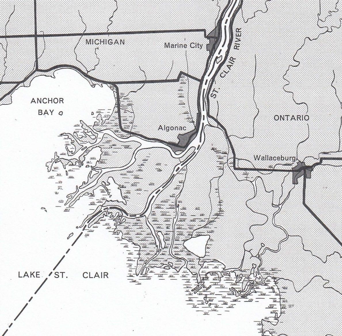
During the last hundred years many writers chronicling the history of Point Edward, Sarnia and Lambton County have mentioned the channels and islands at the mouth of the St. Clair River. They have correctly noted that several of the early European travellers on the river in the 1679 to 1820 period such as Hennepin, Cadillac, Charlevoix, Carver, Barr, and Schoolcroft described these features, as well as the Mississauga village located on one of the islands. However, since many of these history writers were apparently unfamiliar with basic geographic terms, they incorrectly assumed that the mouth of the St. Clair River is in the Point Edward – Canatara area.
Provided below is page 91 from Elements of Geography, the geography textbook used throughout Ontario schools in the 1950’s & 60’s. As it correctly states, a river flows downhill from its head to its mouth. Since the St. Clair River flows downhill from north to south, its head is at Point Edward and its mouth is at Lake St. Clair. At its mouth is the large delta consisting of several channels and islands shown on page 97 of the Elements of Geography provided on the following page. The channels and islands described by early European travellers, therefore, are in the delta where the rivers enter Lake St. Clair, not at Point Edward. Much of the misunderstanding of the geographic features and history of the native peoples in the Point Edward – Canatara area could have been avoided if writers had understood this fundamental geographic fact.
Parts of a River
“There are many terms associated with the drainage of an area that must be defined in order to avoid misunderstanding. We have already used the terms river and steam to denote the flow of water that has been channeled and therefore is following a definite course. The former term usually implies a larger flow than the latter, but we shall use the terms interchangeably. The head or source, of a river is the place where it first makes its appearance as a surface stream. It is obviously the highest point of the stream. The river flows downhill to its mouth – the point where it ends, either by entering a sea or lake or by joining another river.”
Smyth, J.M., Brown, C.G., } and Fors, E.H. Elements of Geography (revised edition) 1964
The St. Clair River delta. What type of delta is it? What does this reveal about Lake St. Clair?
Answer: It’s a bird’s foot delta and it reveals that Lake St. Clair is a shallow lake where the shoals and sand bars forming the “feet” can readily develop.
The geographic features and the activities of the native people at the head of the river are described in greater detail below. The Mississauga village on one of the islands at the mouth of the river is described in the following brief account from, “A Memoir of the Indians of Canada” by an anonymous author in 1718. (Wisconsin Historical Collection Vol. 16, pp369-70)
“5 leagues from Detroit is a small lake called St. Claire which is 7 leagues in length and not very wide, as one can see the land on either side.
12 leagues from the Fort of Detroit, always ascending the strait, you will find the Missisaguey Indians, who dwell on a beautiful island where they have cleared some land. They number about 60 or 80 men.
8 leagues further is the entrance of Lake Huron.”
On the 1730 Boishébert map (page 9) this village is marked “Les Misissagi´on the island called “I. de Nenche” by the French. Today it is known as Harsens Island.
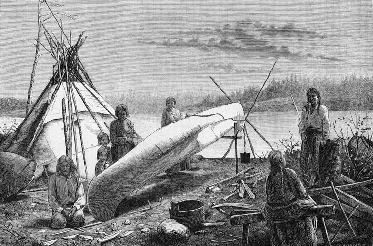
(1) Activities of The Native People in The Point Edward – Canatara Area
The native people, with their extensive knowledge of the natural environment, took full advantage of the fact that fish are concentrated in and around the rapids at the narrow head of the St. Clair River. The Blue Water Bridge archeological site excavated in the 1990’s revealed that over the last two thousand years native people have used a wide variety of tools & fishing techniques to harvest the abundant fish at this location. The tools created to catch the different fish species such as sturgeon, perch, pickerel, whitefish and herring included toggle-headed harpoons, three-pronged spears, gorges, barbed hooks and net sinkers. Concerning the net sinkers found at this site, S.L Prowse noted:
“The great variety of different shapes and sizes of stone net sinkers suggest that people choose the equipment most suitable for a particular type of fishing and its associated water conditions. The site had a spring seine net fishery for spawning walleye and an intensive summer sein net fishery for spawning freshwater drum.”
The site also contained a huge deposit of fish bones, various tools for cleaning fish and a large number of pieces from storage vessels and cooking pots. In addition, there was evidence of postholes from the foundations of fish racks used for smoking and drying the fish.
Artifacts such as spear and arrow heads were also found at this site. They indicate that the native people hunted deer, beaver, mink, muskrats, raccoons and other mammals, as well as the passenger pigeons, wild turkey, trumpeter swans and ducks that were plentiful in the woodlands and marshes in the Point Edward – Canatara area at certain times of the year. Deer in particular were hunted in the autumn when they foraged for acorns in the open oak woodland where the Canatara picnic grounds are today. The deer, like other animals, were used for more than just meat, as Needs-Howarth pointed out:
“Deer hides were used for clothing and shoes. Antlers made good hammers and flakers for flint knapping. The bones were used for making all sorts of tools such as awls and knitting needles.”
In addition, the native people harvested many types of fruit such as raspberry, blueberry, elderberry and sand cherries, as well as nuts from the butternut, black walnut, hickory and beech trees that grew in the hardwood forest on the east side of Point Edward, including what is today the Tarzanland Nature Preserve in Canatara Park. Acorns from the oak woodland in the Canatara area were also gathered during the fall. In fact, as several local residents mentioned when interviewed in the 1990’s, the native people collected acorns in Canatara Park up until the early 1900’s. Cattails from the large marshes in the Point Edward – Canatara area were also procured for several purposes. Their roots and heads were eaten, while the leaves were used for weaving floor mats and roofing. According to several native historians, roots from the aquatic plants in
the marsh around Lake Chipican provided medicines for an assortment of ailments and infections. Indeed, one theory concerning how Lake Chipican got its name revolves around the fact that Chipican means, “Lake of The Roots” in the Ojibwa language. Herbs such as boneset, jewelweed, sunflower, wild mint and yarrow were also gathered for medicinal use.
In a 1926 Observer article, (Dec. 8, p9) Chief Jacobs of Sarnia wrote of an Ottawa chief who travelled from Lake Erie up to Georgian Bay in the early 1800’s. The portion of this article quoted below gives a brief glimpse into the Point Edward – Canatara area before the European settlers arrived.
“… on his way up he pitched his teepee at Saw-won-go-ing, which is now known as Point Edward where his kindred tribes (the Chippewa’s) were living and his visit was welcomed by the whole tribe. They made it so pleasant for him and his troupe that he decided to remain there for a time. The scenery of the district was pleasant, and the forest surrounding had teeming millions of game & untold millions of fish at the rapids and ducks almost covered the bay, as well as the river.”
It was about the same time this Ottawa Chief visited Point Edward, that another story concerning the naming of Lake Chipican arose. According to a 1949 Observer article (July 2 p11), written by native historian Philip George, Lake Chipican was named in the early 1800’s for a native girl called Chip – Kan, which means root in English. She was the sister of Eliza Maccoose, the wife of Chief Joshua Wawanosh.
The evidence obtained from the Blue Water Bridge site and other archeological sites around the Great Lakes demonstrates that the native people had an intimate knowledge of all aspects of their environment. They knew the behavioural habits of many species of animals and the nutritional value of many species of plants. They understood the natural processes that formed the land, changed the weather and altered the vegetation. They utilized this knowledge to create carefully crafted tools and sophisticated techniques for harvesting the natural resources in the Point Edward – Canatara area for a wide variety of uses. Their deep appreciation of nature and their self-sufficient lifestyle also led them to adopt a spiritual concept of living in harmony with the natural environment. For century after century and generation after generation they lived according to the natural cycles & processes they knew so well, until one day a strange boat appeared on the river. It heralded the arrival of another group of people – the Europeans – who in a relatively short time changed the lives of the native people forever.
(2) Early European Period: 1679 – 1829
Hennepin’s Description of The Mouth and Head of The St. Clair River
In 1679 a small sailing vessel, the Griffon, passed through the waterway between Lakes Erie and Huron which the French called the “Detroit” (the strait). On board were LaSalle and 31 others including Louis Hennepin, who left a famous account of this journey in his 1683 book, “Description de la Louisiane”. In the chapter entitled, “An account of what happened in our passage from Lake Conty (Erie) to Lake Orleans (Huron)” he highlighted the navigational problems encountered at both the mouth and head of the St. Clair River.
“There is little depth as you enter and leave Lake St. Clair, especially as you leave it (the mouth). The discharge from Lake Orleans divides at this place into several small channels, almost all barred by sandbanks. We were obliged to sound them all, and at last discovered a very fine one with a depth of 2 or 3 fathoms of water and beyond the sandbanks, almost a league wide in all points. Our bark was detained here (the mouth) for several days by headwinds and this difficulty having been surmounted, we encountered a still greater one at the entrance to Lake Orleans (the head), the north wind which had been blowing some time rather violently and which drives the waters of the three great lakes into the strait, had so increased the ordinary current there, that it was as furious as the bore is before Caudebec (Niagara). We could not stem it under sail, although we were then aided by a strong south wind, but as the shore was very fine we landed 12 of our men who towed it along the beach for a quarter on an hour, at the end of which we entered Lake Orleans.”
Notice that Hennepin attributes the strong current or rapids at the head of the river to the fact that a north wind had increased the flow through it, rather than the narrowness of the river at this location, which is the actual cause of the rapids, as explained below. Nevertheless, from Hennepin’s account of a strong current we can infer that the head of the river was very narrow as is confirmed by a letter written 7 years later, as recorded below.
In general, it can be seen that Hennepin’s description, rather than giving a detailed account of the entire journey up the river, focuses specifically on the two geographic features – the shallow channels at the mouth of the river and the rapids at its head – that present problems for the navigation of sailing vessels. When sailing craft again began passing through the river in the 1770’s, they encountered the same obstacles recorded by Hennepin. This fact is noted by Mansfield in his well-known summary of Hennepin’s journey (see below). For additional information concerning these two navigational problems in the 1770 – 1850 period, see note 1 in the addendum.
It may also be noted that Hennepin’s remark regarding several channels clearly refer to the delta at the mouth of the St. Clair River and not to the Point Edward – Canatara area at the head of the river, as a number of writers have mistakenly claimed. These writers, by the way, do not include Jean Elford, who in her book, “Canada Wests’ Last Frontier – p114,” correctly stated that the channels Hennepin mentioned are at the delta of the river. Likewise, George Smith in his book, “A History of Sarnia to 1900, p4,” wrote that the story of several channels at the head of the river is a myth. For further enlightenment regarding this issue see note 2 in the addendum.
From: MJB Mansfield, “History of the Great Lakes” 1899
“On the 10th of August, the Festival of St. Claire, they entered and crossed the lake, which they named after that saint. In attempting to pass from the lake into the river above, they encountered the same obstacles which, after a lapse of two centuries confront the mariners of to-day. In describing it, Hennepin says: “We found the mouth of the St. Clair River divided into many narrow channels full of sand bars and shoals. After carefully sounding them all we found a very fine one two or three fathoms deep and almost a league wide throughout its entire length.” Contrary winds delayed their progress through the St. Clair River for several days. At length they
were enabled to approach Lake Huron, but the violent current, increased by a northerly gale, prevented their advancing. The wind shifting to the south, they succeeded with the aid of a dozen men towing on shore, as at the outlet of Lake Erie, in surmounting the rapids, which were pronounced by Hennepin almost as strong as those of Niagara.”
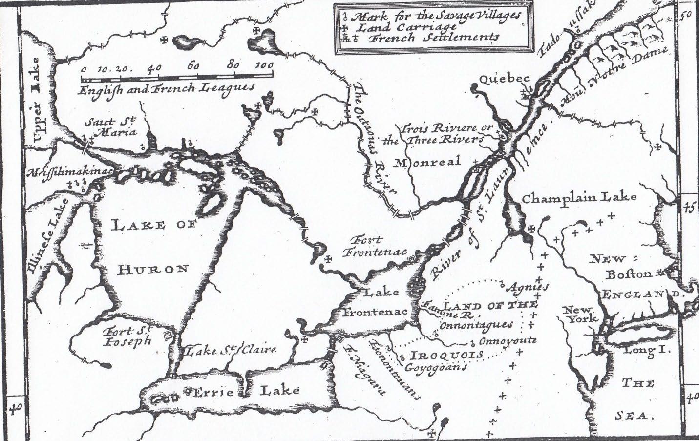
Map A7: The 1703 Lahontan Map
In 1686, just seven years after the Griffon was pulled up through the rapids at the head of the St. Clair River, Duluth, the famous French explorer, along with some coureurs de bois, constructed a small fort, known as Fort St. Joseph, on what is now the American side of the rapids, (see Map A7 below). That same year, Denonville, the Governor of New France, sent a letter to the Count de Pontchartrain (see below) which noted that the fort was strategically located at the “narrowest part of the river,” where any English fur traders attempting to pass through could be seen and intercepted.
(For further information about Fort St. Joseph, see Note 8 in the addendum.)
Wisconsin Historical Collection
1686 ca: Account of Detroit Post
“Our Fort covers a square of one Arpent in extent, without the Bastions, and is very advantageously Situated on an Eminence, which forms a very pleasant Glacia*. Care has been taken to place it at the narrowest part of the River, which is here a gunshot in width, while everywhere else it is a good quarter of a league.”
*A military term, meaning the mass of earth outside a fort which serves as a parapet to the covered way, and gently slopes to the exterior ground. Du Luth’s fort was built, not at the place chosen by Cadillac in 1701, but at the southern end of lake Huron, apparently at or near the present Fort Gratiot, Mich.
Map A7 was drawn by Lahontan who was the commander at Fort St. Joseph until 1688, when it was abandoned. The map appeared in the first English edition of his book, “Nouveaux Voyages,” published in 1703. Typical of the rudimentary French maps published in the 1650 – 1730 period, it shows no geographic features along the St. Clair River. The coureurs de bois who manned the fort and spent much of their time searching the surrounding area for food and game, were probably the first Europeans to explore the Point Edward – Canatara area.
Map A7
Lahontan’s map of New France and the country of the Great lakes. Fort St. Joseph, where he was stationed for a time in succession to DuLhut, is shown at the outlet of Lake Huron.
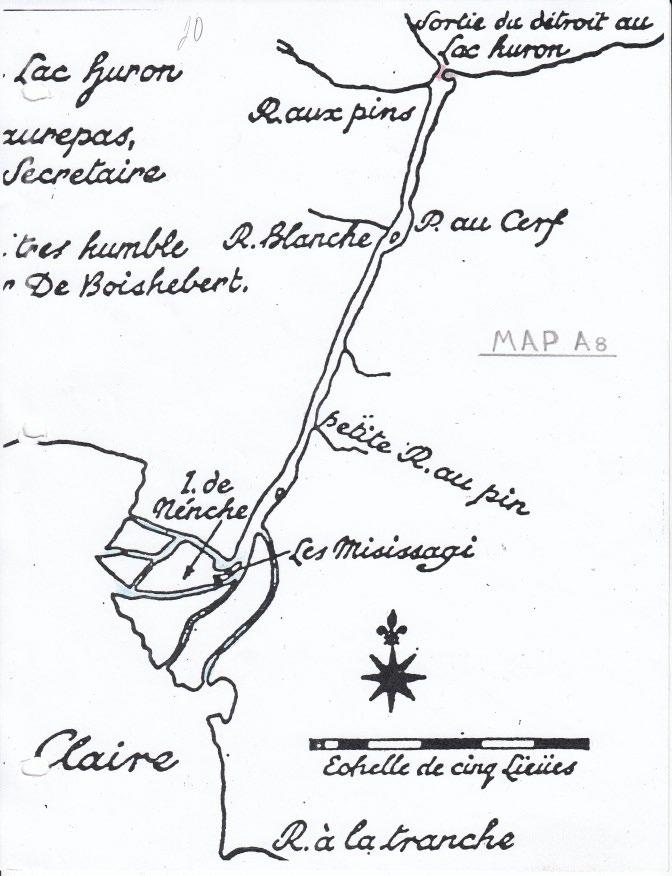
Map A8: The 1730 Boishébert Map
In 1701, thirteen years after Fort St. Joseph was abandoned, Cadillac and approximately 100 soldiers and workmen constructed Fort Pontchartrain on the present site of downtown Detroit. Over the next quarter century, the French at this fort carried out various nautical surveys in order to produce a detailed map depicting geographic features such as islands, shoals, channels and tributaries along the strategic waterway connecting Lake Erie and Lake Huron. In 1729, when Boishébert became commander at Fort Pontchartrain, he set about correlating all this geographic information. In 1730, after collecting these data and making his own fact-checking survey, he drew the first large scale map of the Lake Erie to Lake Huron waterway, the northern portion of which is depicted on Map A8. (A copy of the entire map is included in the addendum).
As is readily apparent, this is an extremely accurate map that shows most of the geographic features along the St. Clair River with remarkable precision. Notice, for example, that both Fawn & Stag islands are marked in their correct location along the river, which is accurately portrayed as being 12 leagues long and ¼ league wide.
At the head of the river is the gravel deposit (coloured grey) as shown on Map A5, and the narrow channel (coloured red) as noted in Denonville’s letter. This is also the location of the rapids described by Hennepin in his 1683 book. On the lee side of the gravel deposit is Sarnia Bay, with the Black River entering from the west side. Only the long spit that forms the western side of Sarnia Bay as shown on Map A4 is not depicted, which isn’t surprising considering the scale of the map.
In the delta at the mouth of the river are the channels (colored blue) noted by Hennepin. The North, Middle, South, Chematogan & Chenal Escarte Channels are all clearly marked, along with the islands between them. Also notice that it shows the location of the “Misissagi” village on an island at the apex of the delta, as mentioned by Cadillac, Charlevoix, & other French travellers in the 1701 – 1730 period. (For specific information regarding French accounts of this Mississaga village, see Note 3 in the addendum).
Since the French didn’t want their English rivals to have an accurate chart of this strategic waterway, the Boishébert map was regarded as a top-secret document made for and seen by only government and military officials. It therefore was never used by cartographers in Europe who had to rely on far less accurate records and reports in depicting this section of the Great Lakes river system. Consequently, many of the maps publish in the 1730 – 1770 period contain gross distortions of the geographic features along the St. Clair River, a flagrant example of which is Map A9.
Map A8 – Boishébert 1730
Map A9: - Del’Isle 1730
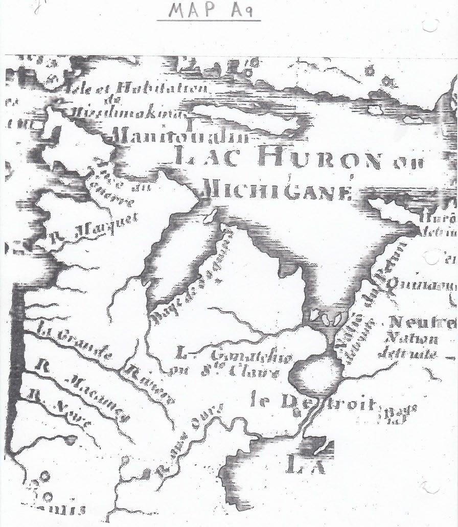
Map A9: 1730 Del’Isle Map
Map A9 is a portion of the “Carte du Canada ou de la Nouvelle France” drawn by Guillaume Del’Isle and published in 1730, the very same year that Boishébert produced his map. Notice that it shows no islands or channels at the mouth of the St. Clair River. However, at its head the map depicts four channels and three islands, each about five leagues long and two leagues wide. Since a league is about three miles, these islands would be about 15 miles by six miles! Obviously, Del’Isle misinterpreted one of the early records describing the St. Clair River and incorrectly transferred the channels and islands from the mouth to the head of the river. Several writers by the way, who were unaware of the Boishébert map, have claimed that this Del’Isle map definitely “proves” that there were four channels at the head of the St. Clair River in the 1700’s. For more information concerning this map, see Note 6 in the addendum.)
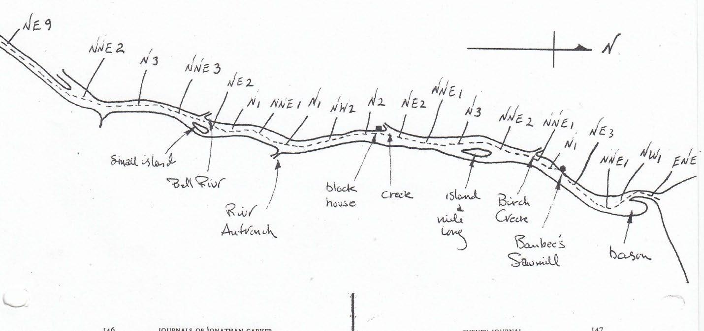
1766 Carver Survey of the St. Clair River
In 1766, just a few years after the Great lakes’ region had been taken over by the British, Johnathan Carver made a survey of the St. Clair River, as shown by the survey notes and map below. As recorded in his notes, he travelled by canoe, northeast up the South Channel for nine miles at the mouth of what he called the “Huron River”. He then proceeded to record all the changes in course, as well as the geographic and cultural features from the apex of the delta to the head of the river. Notice that the geographic features are very similar to those shown on the Boishébert map, which Carver, of course, had never seen. After completing his survey, he was very critical of the many inaccuracies that he found on both French & British published maps.
John Parker (ed): Carvers manuscript Journals 1766 – 1770. Minnesota Historical Society Press – 1976
Weeks / Days Months/Days
Journals of Jonathan Carver
NNE 2
N 3
NNE 3
Remarks &c
The river in general sixty rods wide
Here is a small island [Fawn], and Bell[e] Rivr [at Marine City, Mich] from the west
Small
NE 2
N 1
NNE 1
Here comes in from east Rivr Autronch [Clay Creek?] small
Weeks / Days
Fryday 8 N 1
2
N 2
Remarks &c
To block house [Fort Sinclair]. A creek [Pine R,] comes in from west, 3 rod wid. NE 2 NNE 1
N 3
Passed an island [Stg] a mile long. NNE 2
To Birch Creek on west shore. [near Marysville, Mich.] NNE 1
N 1
To Baubee’s sawmill on a creek, west shore NE 3
1
1 ENE 1
This last 2 miles widen west, forms a basin much wider (Sarnia Bay at Port Huron, Michigan and Sarnia, Ontario.)
In the 1770 to 1850 period, a large number of maps depicting the St. Clair River, including nautical charts, were produced by both British and American cartographers. Although drawn at various scales and with varying degrees of accuracy, they all show a number of channels at the mouth of the river, but only one at its head. This is exactly what one would expect from the transport and depositional processes described by Leverette and Taylor in the notes accompanying Map A5.
General Hunter’s 1800 Letter (regarding a fort at the head of the St. Clair River)
As a result of Jay’s Treaty of 1794, the St. Clair River became an international border between the United States and British North America. To defend this border, in 1800 General Hunter, the Lieutenant-Governor of Upper Canada, recommended that a fort and settlement be established at the narrow head of the St. Clair River, as mentioned in the following letter.
“If the Americans be permitted to settle on the western bank of the river St. Clair and erect a fort at their option, or at the Narrows according to General Alexander Hamilton’s plan, without any measures assumed on our part to counteract them, ‘tis an assault on common sense to pretend that we may support an independent communication with Lake Huron; if on the contrary a settlement be made on our side, industrious settlers encouraged …. A small work constructed in the most convenient and commanding position at or near the foot of the rapids, the fort and settlement will mutually support each other, and assure us a passage into the lakes.” (From Orlo Miller – The Point p.16)
However, nothing was done to implement (26) this recommendation until 1829, when Roswell Mount surveyed the Point Edward Military Reserve, as noted below. The letter, by the way, was sent to the commander-in-chief of the army in the British North American, Prince Edward, the
Duke of Kent, for whom both Point Edward and Prince Edward Island are named. He was also Queen Victoria’s father.
1813 Letter Sent to General Proctor
(describing the rapids at the narrow head of the St. Clair River)
On October 6, 1813, during the War of 1812, General George Prevost sent a letter to General Proctor, a portion of which is quoted below.
“It is known to every person acquainted with the River St. Clair, that near to its sortie’ from Lake Huron, there is a part of it very narrow, not more than one hundred yards across; in this spot there is so strong a current that it requires a very stiff breeze to carry up a vessel. There is a village of Chipiway Indians stationed on the south side of the Rapids, attracted to the spot by the great quantities of fish, which is there to be caught, and it was usual for these Indians to be employed in towing up vessels going into Lake Huron.”
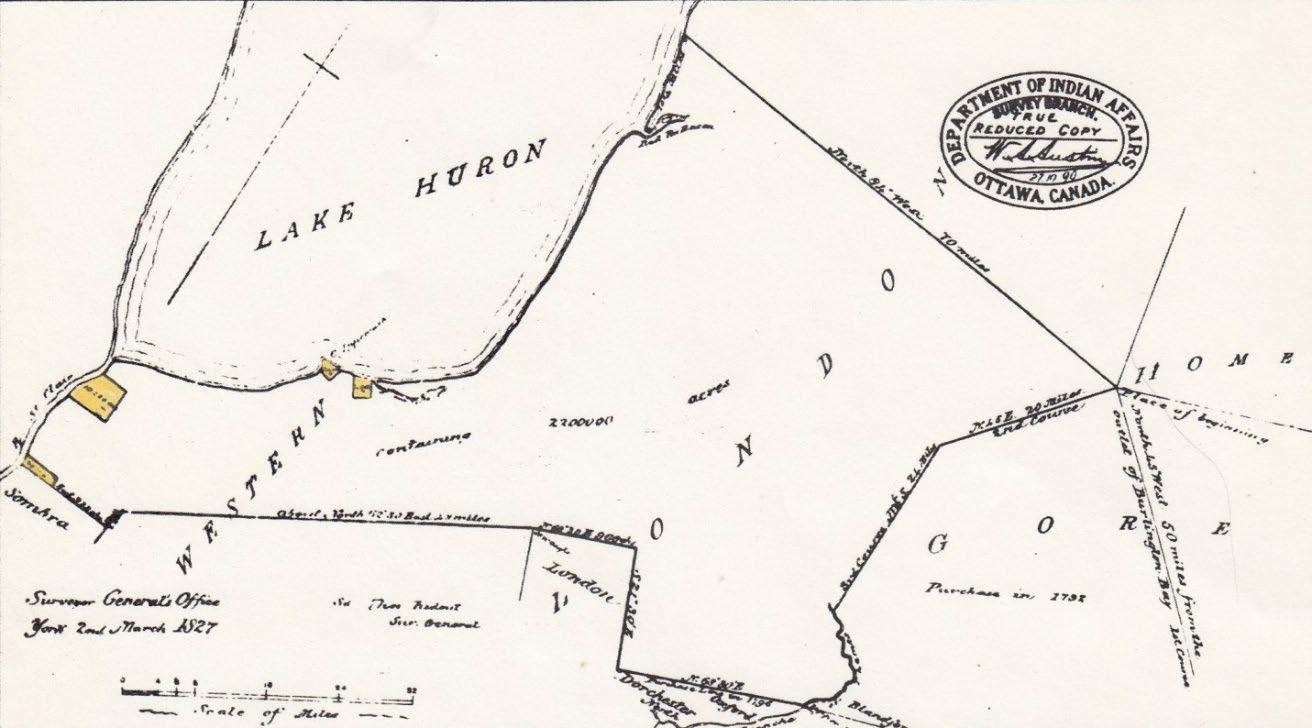
Map A10
In the Treaty of July 10, 1827, the Chippewa’s ceded to the Crown a 2,200,000-acre area including parts of the present-day counties of Lambton, Middlesex, Oxford, Perth, & Huron. The reserves (yellow) included Sarnia, Moore, Kettle Point, & Sable (Stoney Point)
Further on in the letter General Prevost also pointed out that by fortifying this strategic location at the narrow head of the river, the British could control the passage of vessels through it, just as the French Fort St. Joseph had been designed to do.
“If the Indian continued friendly and a band of them was situated at this Rapid, supported by a small detachment of troops and a few guns, it would be impossible for any vessels to pass into Lake Huron……”
Although the British apparently never followed-up on this suggestion, the Americans, in May 1814 – just seven months after this letter was written – built Fort Gratiot on their side of the rapids, just south of where the Blue Water Bridge is today. (The entire letter, which is from the Michigan Pioneer Collections Vol. 15, pp400-401, is included in note 4 in the addendum.)
As shown on Map A10, in 1827 the native people ceded a huge section of Southwestern Ontario including the Point Edward – Canatara area. Two years later Roswell Mount surveyed much of Sarnia Township and soon after the European settlers began arriving
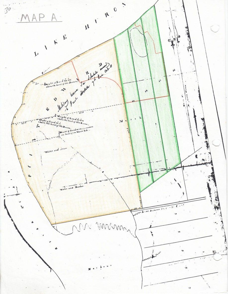
Map A
Map A: Mount’s 1829 Survey
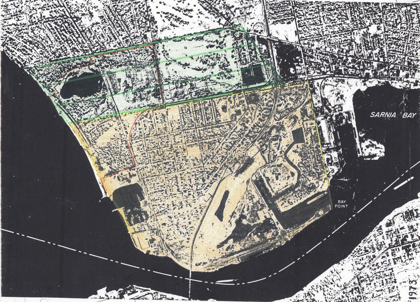
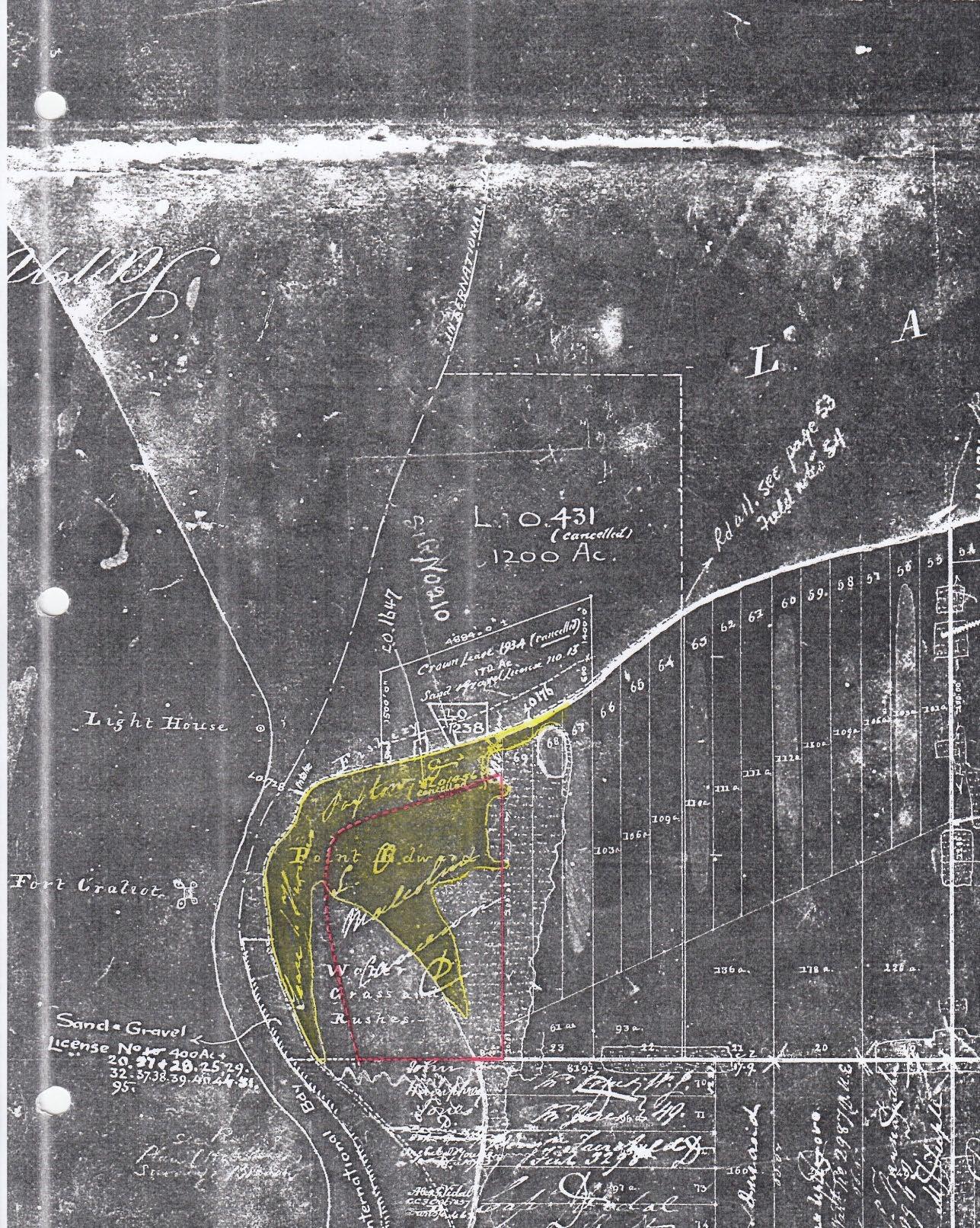
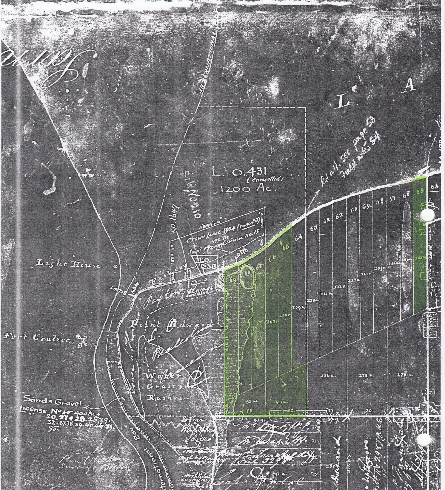
The first survey of the Point Edward – Canatara area was made by Roswell Mount in 1829. Map A is a portion of the survey entitled “Rectangular Traverse of the River St. Clair.” Mount divided the area into a 685-acre Military Reserve (colored yellow) and lots 67, 68, & 69 (coloured green) each containing approximately 100 acres. The future Canatara Park, whose boundary is shown in orange, is located in the northern portion of the three lots and the northeast corner of the Military Reserve.
The aerial photo below, shows the four parcels coloured on Map A in relation to present day features. Notice that the southeast corner of the Military Reserve is today at the intersection of Exmouth and Front Streets. The eastern boundary of the reserve is now Front Street extending northward through Canatara Park to Lake Huron, while its southern boundary is now Exmouth Street extending westward across the North Slip to Bay Point on the river. Also notice that the eastern boundary of lot 67 is today Christina Street extending northward from Errol Road to Lake Huron. The boundary of Canatara Park is marked in orange.
Aerial Photo
(3) Canatara Landscape in the 1830 – 1860 Period And
the Geological History
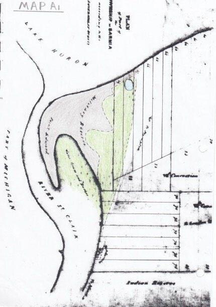
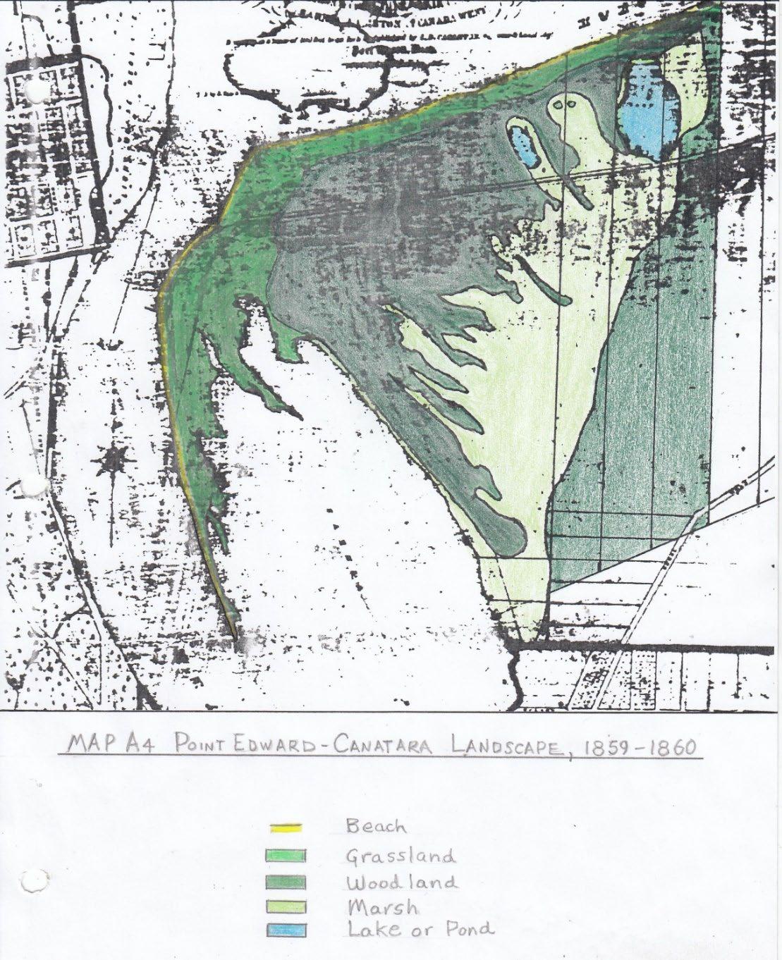
Notes for Maps A, A1 & A4: Point Edward – Canatara Landscape: 1829 – 1860
This sequence of three survey maps depicts a progressively more detailed and accurate representation of the Point Edward – Canatara landscape from 1829- 1860.
Map A:
Mount’s 1829 survey depicts a large marsh (coloured green) in Sarnia Bay and another marsh, with an undefined border (also coloured green), on the east side of Point Edward, between the Bay and lake Chipican (coloured blue).
Map A1:
This map was sketched by Alexander Vidal in 1848 and shows the approximate border of the marsh on the east side of Point Edward extending from Lake Chipican to the southeast side of Sarnia Bay. Notice that it also depicts several broad points or ridges of the Point Edward spit (coloured grey) projecting into the west side of the marsh. This marsh and Lake Chipican are typical lagoonal features often located to the lee of coastal bars and spits. Former Lakes Wawanosh and Burwell, as well as the marshes which surrounded them, are other examples of lagoonal features that were once located in Lambton County before being drained for agricultural purposes
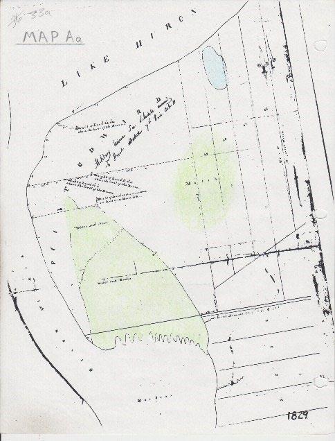
Map A1 Map Aa
Map A4:
This map is the northeast portion of a Grand Trunk Railway map of the Sarnia – Port Huron area published in 1867. It is based on a detailed survey of the Grand Trunk Lands at Point Edward made in the 1859 – 1860 period when the railway acquired this property, as recorded in Volume 2. (This survey, known as the “1860 Sarnia Survey”, is in the PAC.)
Map A4
Map A4 obviously depicts the Point Edward – Canatara landscape with far greater accuracy than the previous two. Notice that it shows the two prominent tree-covered ridges that protrude like fingers into the marsh between Lake Chipican and the small pond where the Canatara ballfield is now located. (The marsh between these ridges is where the Children’s farm is now located). Since the oak woodland that covers these two ridges has been preserved, they are still recognizable features of the Canatara landscape, as demonstrated by the three 1997 aerial photos provided below.
In the Military Reserve & lots 67,68, & 69, the map shows the areas where the plant community consisted predominantly of grassland, woodland or marsh. Records from the 1830 period reveal that the woodland in the lagoon bordering the east side of the marsh contained wetland trees such as tamarack and elm, while oak trees were dominant on the sub-parallel ridges of the spit. Since the rot-resistant wood of the tamarack is ideal for making railroad ties, these trees were cut down when the Grand Trunk Railway tracks were laid through the Canatara area.
Although not shown on Map A4, early records mention that there was a ridge of large sand dunes adjacent to Lake Huron where the beach parking lots in Canatara Park are located today. For example, Smith’s Canadian Gazetteer of 1846 noted that:
“Lake Chipican, a small lake about 6 acres in extent is separated from Lake Huron by a ridge of high land.”
As explained in Volumes 3 & 4, these large coastal dunes, which contained a huge amount of sand that had gradually accumulated over several thousand years, were removed during a railway sand mining operation.
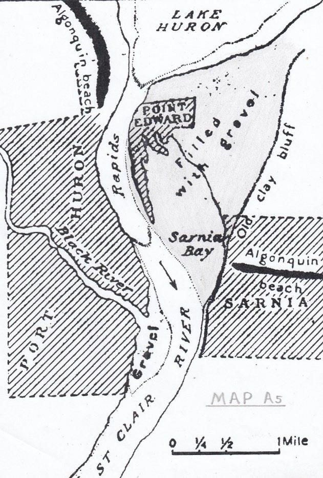
Map A5: Point Edward – Canatara Geology
This map is from F. Leverette & F.B. Taylor, c1915 U.S. Geol. Surv. Mon. 53. It is based on geological field research carried out at Point Edward in the 1890 – 1910 period before much of the area had been altered by human activities. Concerning the large gravel deposit (colored grey) that forms the foundation or “platform structure” of the spit, Leverett & Taylor note that:
“The gravel mass at Point Edward measures 1 ½ miles from east to west and about 2 miles from north to south.”
They go on to describe the shore processes that created both the gravel deposit at the head of the St. Clair River & the delta deposit at the mouth of the river. For thousands of years shore currents have moved material eroded from the cliffs along the Canadian shore of Lake Huron southwestward toward Point Edward. Once there this material has separated. Most of the coarse sand and gravel have been deposited at the head of the river as shown on Map A5, while most of the finer silt and clay sediments have been transported down to the mouth of the river where they have gradually accumulated to form the large delta in Lake St. Clair. (For more information concerning the formation of deltas, see the page below from Judson Kauffman - Physical Geology, 1990.
“Deltas and Alluvial Fans: For thousands of years the Nile River has been depositing sediments as it empties into the Mediterranean Sea and thus forming a great triangular plain with its apex upstream. In the fifth century B.C. the historian Herodotus introduced the term delta for this plain because of the similarity between its plan and the outline of the Greek letter Δ. (Figure 13.38).
Whenever a stream flows into a body of standing water, its velocity and transporting power are quickly stemmed. If it carries enough debris and if conditions in the body of standing water are favourable, a delta will gradually form. The drainage across a delta is by a series of channels diverging from the apex. These branching channels, or distributary channels, build the delta. As sediment is deposited along a distributary channel, its bed and banks build up above the surrounding area. In time, the distributary stream escapes its old channel and forms a new one. The process continues to repeat itself on the ever-growing delta.
13.38: the delta (darker area) of the Saint Clair River has the classic shape as well as its distributary channels.
At the outer end of a distributary channel sediments may be arranged in a definite pattern. The coarse material is dumped first, forming a series of dipping beds called foreset beds. But the finer material is swept further along to settle across the sea or lake floor as bottomset beds. As the delta extends farther and farther out into the water body, the stream must extend its channel to the edge of the delta. As it does so, it covers the delta with topset beds, which lie across the top of the foreset beds.
Very few deltas, however, show either the perfect delta shape or this regular sequence of sediments. Many factors, including shore currents, vary rates of deposition, the compaction of sediments, and the down warping of the Erath’s crust, conspire to modify the typical deltaic form and sequence. Deltas are characteristic of many of the larger rivers of the world, including the Nile, Mississippi, Ganges, Rhine, and Rhone. “
Notice on Map A5 that the eastern edge of the gravel deposit is located along the ridge that stretches from the west side of Front Street in downtown Sarnia to the east side of Lake Chipican. This ridge separates the upland to the east from the bottomland to the west and is marked by the 590-foot contour line on topographic maps such as Map A6. It was the shoreline on the east side of a wide shallow entrance to the St. Clair River about 3,000 years ago.
As sand and gravel built out from the east side they filled in this shallow entrance and crowded the river over to the west side. By 2,000 years ago this depositional process had narrowed the river to such an extent that the water being squeezed through it became very turbulent, creating a rapids at this location. As Leverett and Taylor pointed out:
“The current in the rapids flows at 4 1/2 miles per hour, and the relations show plainly that the existence of the latter is due to the narrowing of the river caused by the growth of the gravel mass westward.”
Furthermore, the turbulent water scoured out the riverbed, confining the river to a deep narrow channel known as a “vent”.
As the gravel deposit continued to grow, the swift current in the now constricted river began to slowly erode the shoreline on the west side of the entrance. Again, Leverett & Taylor pointed out:
“The west bank of the rapids has no protection against the swift current and is eroded away as fast as the gravels on the east side press westward.”
This westward migration of the river has produced a pronounced bend or meander at its head. Leverett and Taylor mentioned this bend when they noted how young the St. Clair River is on the geologic timescale.
“The St. Clair River bears many evidences of the fact that it is of recent origin. One is its straightness and the absence of any but very slight curves or meanders. The only feature suggesting lateral cutting is the bend in the rapids at the north end of the river due to the spit encroachment.”
In summary, the rapids, the deep narrow channel, and the bend in the river have all resulted from the westward growth of the gravel deposit depicted on Map A5. (For more information concerning the geomorphic history of the St. Clair River, consult the Master’s Thesis of R.W. Wrightman in the Geography Department at Western University. Additional information about the Point Edward spit is also included in Note 5 of the addendum.
During the 1927 to 1940 period a large amount of gravel was excavated from two sections of this huge deposit. As described in Volume 4, from 1928 – 1940 dredges and sand suckers were used to excavate gravel from what is today the Sarnia Yacht Club Basin. In 1928 a Windsor construction company formulated plans to remove the millions of cubic yards of gravel
Map A5
underlying what is now Canatara Park. Only the Great Depression of the 1930’s prevented much of the future park being turned into a giant gravel pit. Large amounts of gravel were also excavated from the southern section of the deposit in the 1927 – 1930 period when both the elevator and north slips were dredged in Sarnia Bay. (For more information about the dredging in the southern section of the gravel deposit, see Note 13 in the addendum.)
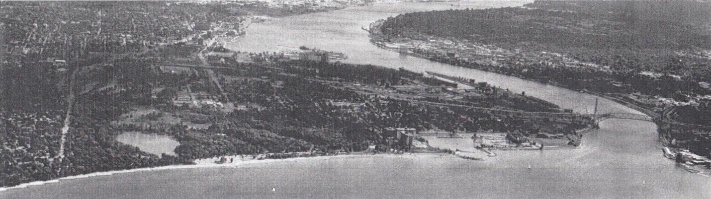
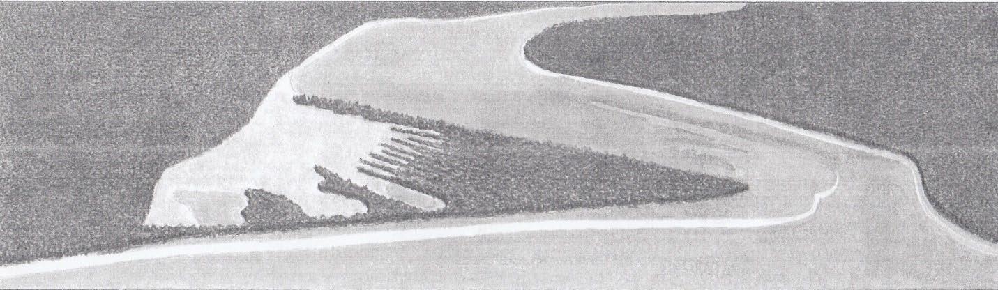
1996 Aerial Photograph & Accompanying Drawing
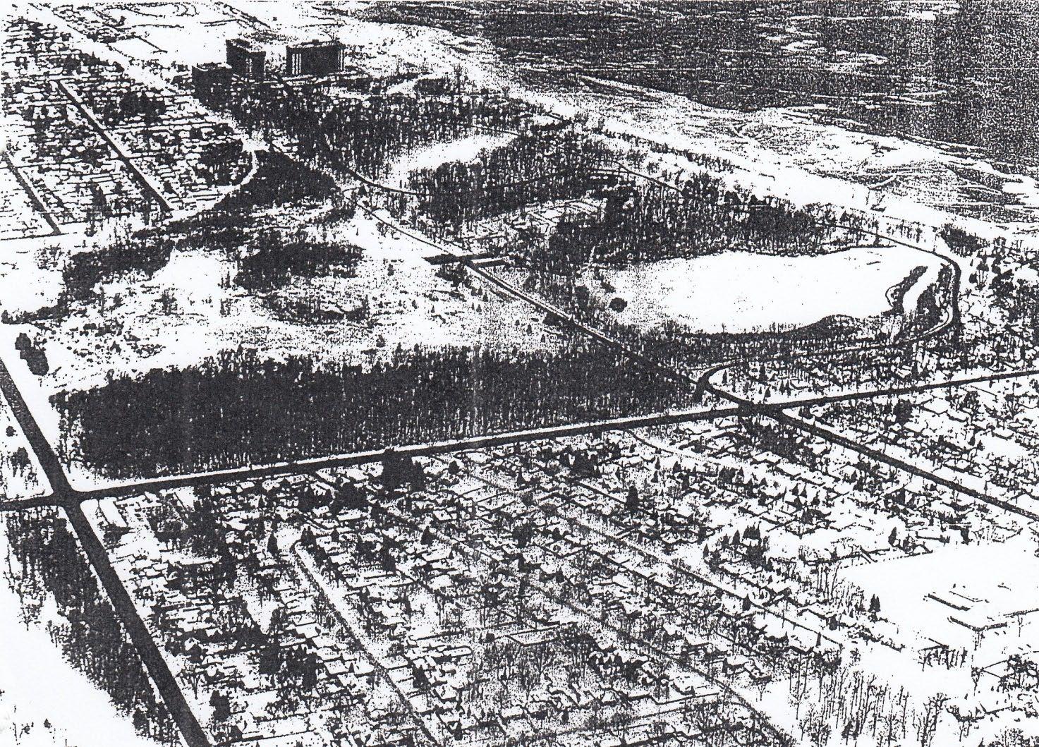
The 1996 aerial photo below was taken over Lake Huron looking south at Canatara Park and Point Edward with downtown Sarnia & Port Huron in the background.
The drawing on p40(b) depicts the same view in about 1800 before any human alterations to the landscape. It shows how the gravel and spit deposits have filled the once wide river entrance as indicated on Map A5. This depositional process contracted the river and displaced it westward, causing it to erode into the west shore. Lake Chipican and the ballfield pond are small remnants of the former wide river entrance that existed about 3,000 years ago.
It might also be noted that the geological evidence presented above corroborates the oral history of the native people regarding the changes they witnessed at the head of the St. Clair River thousands of years before the Europeans arrived on the scene. As the following account recorded in 1883 (History of St. Clair County, Michigan) demonstrates, the native people accurately described the basic geomorphic processes that created both the rapids and the deep narrow channel.
“According to the Indian tradition the ancient river channel was fully a half mile east of the present channel and the Indian canoes passed directly from the lake into the head of Sarnia Bay. The river was then a broad shallow stream fully 4 or 5 times its present width and scarcely twenty feet in depth. The changes are a result of lake currents carrying down the sands along the eastern shore until near the outlet they gradually accumulated, forcing the stream into a narrower channel, increasing the rapidity and depth of the waters and finally carving out a deep channel where in olden times was a shallow stream.”
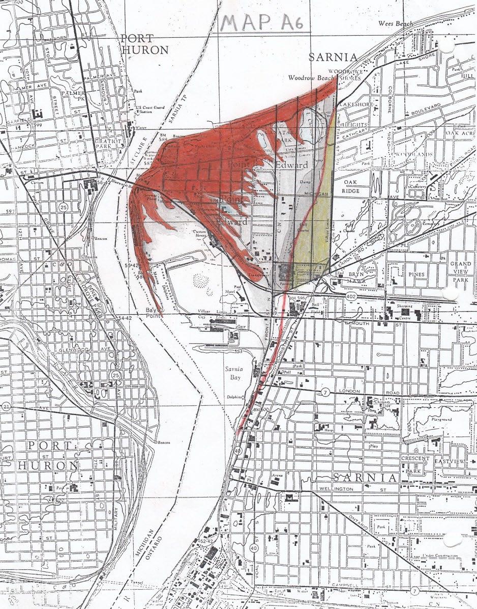
A6
Map
Notes for Map A6
This map was created by combining the 1:25,000 Perch and Sarnia topographic sheets, both of which were surveyed and published in the 1960’s. The spit formation depicted on Map A4 is coloured orange on Map A6 to show its location in relation to present day features. Notice, for example, that St. Clair Avenue in Point Edward follows the long ridge that separated Sarnia Bay from the lagoon.
The entire spit complex includes the bars, ridges and dunes that comprise the upper portion of the massive gravel deposit shown on Map A5. Most of these landform features have been destroyed over the last 150 years by urban development in Point Edward. However, remnants of the ridges and sand dunes still exist in Canatara Park, as noted above.
Much of what is now the eastern section of Point Edward and Canatara Park was in the marshfilled section of the lagoon (colored light grey). What is now the west side of both the Sarnia Golf Course and the Tarzanland woodlot was in the wooded wetland situated along the eastern side of the lagoon (colored dark grey). Over the last one hundred years almost the entire lagoon has been drained and in-filled to provide sites for various human activities. The last remnants are located in Canatara Park and include Lake Chipican and the marsh surrounding it, as well as the narrow strip of wooded wetland along the western fringe of Tarzanland.
The ridge that runs from downtown Sarnia to Lake Chipican is colored red and generally follows the 590-foot contour line. On the former sites of both Holmes Foundry & the Autolite factory this ridge no longer exists since it was graded and removed during the construction of these two industrial facilities. The ridge separates the lower land to the west from the higher land to the east - coloured yellow in lots 67,68 & 69.
The western edge of the gravel deposit marked with a dotted line on Map A5, is shown with a similar line on Map A 6 It indicates the dividing line between the shallow water to the east from the deep river channel to the west. Notice that Sarnia Bay, which once extended north to Michigan Avenue in Point Edward, is now confined to a small area adjacent to Centennial Park. As with the lagoon, most of Sarnia Bay has been in-filled to provide sites for various human activities.
Finally, note how the in-filling and urbanization of both the lagoon and bay has completely concealed the distinctive shape of the multi-recurved spit and transformed the Point Edward landscape. This illustrates how detailed historical maps such as A4 can be sued to assess the magnitude of human alterations to the landscape. The Point Edward example represents just a microcosm of the vast human-made environmental changes that are taking place in many parts of the world.
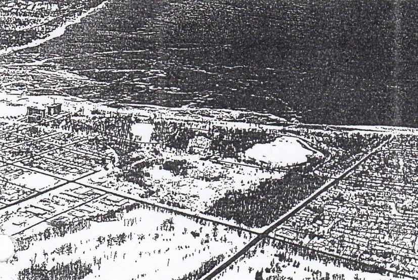
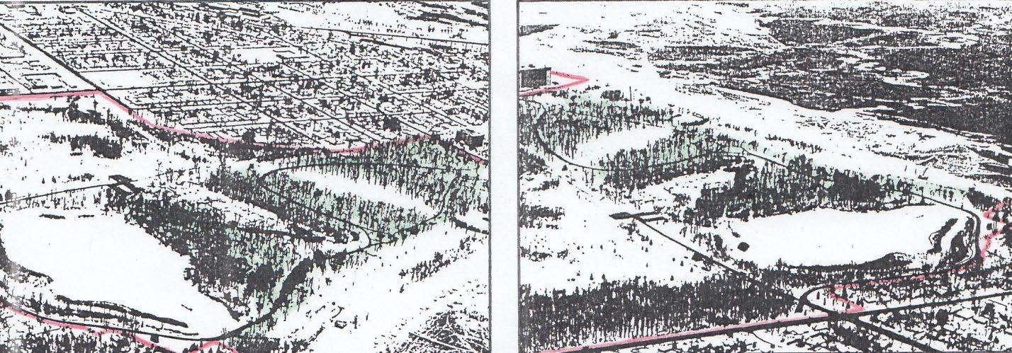
Notes for 1997 Aerial Photos: 1 & 2
Photo 1 (left) shows the view looking southwest over Canatara Park in January 1997. The residential area of Point Edward is in the middle distance and part of Sarnia Bay is in the background.
Photo 2 (right), which was taken at the same time, looks northwest over the park with Lake Huron in the background. The park boundary on both photos is marked red.
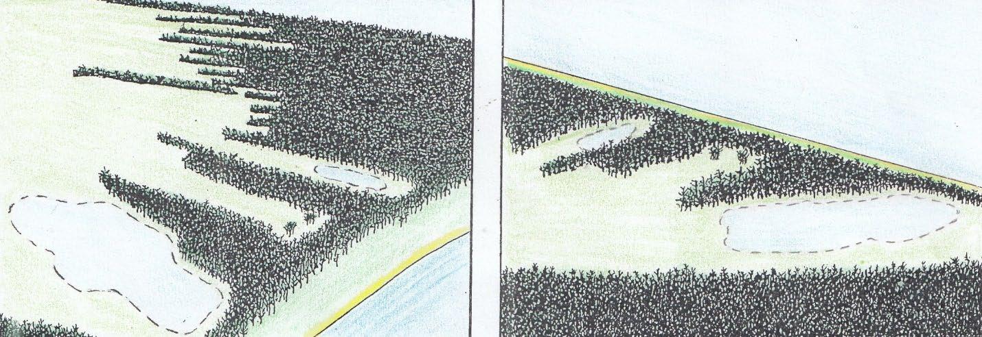
Diagrams 1 & 2, which are based on Map A4, depict how the same views would have appeared about 1850, before any human-made alterations to the landscape. They show the tree covered ridges extending into the marsh-filled lagoon. Notice that the oak woodland in the park, which is colored green on photos 1 & 2, preserves the 1850 landscape structure depicted in diagrams 1 & 2.
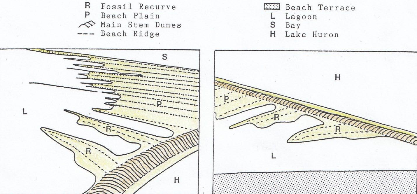
Figures 1(left) & 2 (right) show the underlying geomorphic features – bars, ridges and dunes –that produced the landscape structure depicted in diagrams 1 & 2. Just inland of the storm beach along Lake Huron is the ridge of large coastal dunes that formed the main stem of the spit. Dune grass anchored the growing windward face of the dunes while trees covered the crest and back slope. The series of sub-parallel beach ridges represent the “growth lines” of the multi-recurved spit that formed the upper part of the gravel deposit. These ridges, known as “spit recurves”, can be used in deciphering the growth history of the deposit as it advanced from east to west across the river entrance. As outlined in Note 5 of the addendum, according to Leverett & Taylor’s explanation of how the deposit evolved, the oldest ridge or “fossil recurve” is the one that forms the west side of Lake Chipican and the youngest one is the long “active recurve” at the growing western end of the spit adjacent to the river. As they reported in 1915:
“These spit gravels are presently growing westward and pushing the river further into the land on the west side.”
Also notice on Figures 1 & 2 that the southern ends of the ridges protrude into the lagoon, which is a typical characteristic of multi-recurved spits. These protruding southern ends can be seen on Map A4, with the one on the west side of Lake Chipican being the first in the chronological sequence and the one on the east side of the river being the last or most recent. This sequence of spit recurves, therefore chronicles the successive stages in the westward growth of the gravel deposit, and is somewhat analogous to the sequence of growth ridges on a clam shell or the sequence of growth rings on a tree.
Along the bottom of figure 2 is the Lake Algoma beach terrace located just above the 590-foot contour line. The western section of this terrace formed the shoreline on the wide entrance to the river as Lake Algoma dropped to the Lake Huron level about 3,000 years ago. (For additional information on Lake Algoma, see Hough, 1963, “Prehistoric Great lakes of North America” American Scientist, Vol. 51, p105, and W.D. Ellis, 1974, Land of the Inland Seas, p33.
(4) Activities in the Point Edward Canatara Area: 1827 – 1857
Land Ownership Sequence: 1827 – 1857
Military Reserve:
July 24, 1856: Crown to Gzowski & Co.
Gzowski & Co.:, the contracting firm for the western section of the Grand Trunk Railway (GTR), consisted of the following four partners:
Alexander Galt
Luther Holton
David MacPherson
Casimir Gzowski
As recorded in Volume 2, they purchased 644 acres of the Military Reserve.
Lots: 67, 68, & 69
1. 1827: Crown to Henry Jones
Jones received a grant of ten thousand acres in the north part of Sarnia Township along Lake Huron to establish a colony of settlers from Britain. This settlement, which was in the Bright’s Grove area, soon failed and most of the land grant, including lots 67.68. & 69 – reverted back to the Crown.
2. 1829: Henry Jones to Crown
3. December 7, 1830: Crown to Samuel Street
Street was a wealthy businessman and land speculator from the Niagara District who never lived in Lambton County. His grant included all the land in Sarnia Township north of the line between the 6th and 7th concessions except for the 600 acres that Henry Jones retained. This 14,199 acre tract included all of lots 67, 68 & 69.
4. September 8, 1841: Samuel Street to George Durand
Durand came to Sarnia which was then known as “The Rapids”, in 1833. He opened Sarnia’s first store, operated its first sawmill and was its first postmaster. As shown on Map A3, he bought all of lots 67.68 & 69.
5. June 29, 1853 ((lots 67 & 68) George Durand to September 3, 1853 (lot 69) Luther Holton
Holton was a prominent financier, railway promoter, land speculator & political figure from Montreal. As a partner in Gzowski & Co., he bought 440 acres adjacent to the Military Reserve in 1853, including lots 67.68 & 69. All the property he purchased in 1853 is shown on Map B in Volume 2.
Conditions in Sarnia and Point Edward: 1830’s & 1840’s
The following three Observer items describe the conditions in the Sarnia – Point Edward area when the first European settlers arrived.
Observer, August 13, 1934, p2. Letter by Charlotte Nisbet
“On Friday, the 17th of August, it will be exactly 100 years since my grandfather, Captain R.E. Vidal, arrived here with his family to take possession of his Crown grant…… The contrast between the state of things as they were in 1834 and as they are now, is very great. There were no roads, only tracks along the waterfront of the lake and river, and through dense forests avoiding as much as possible the extensive swamps and marshes. There were no streets, no lights, very few houses, no mail service, no railway, no telegraph & no ferry.”
Observer, August 25, 1934, p3. Centennial of the James Simpson Family
“In 1834 the township was heavily wooded, and roads were nothing more than trails, with blazed trees the only signpost to indicate that one was on a travelled track. Game of all kinds abounded in the district and protection was necessary against wolves & bears, which were very numerous. Wild duck, turkey, and geese were abundant, and the drumming of the beavers was heard continually in the swamps. Carrier pigeon, now almost extinct, existed in huge flocks, darkening the sky.”
Observer, July 18, 1925. Marcus Hitchcock’s description of Point Edward in the 1840’s
“The Point as they call it at the present time, in those days was a complete forest of scrub oak, hazel nut bushes and wild grape vines and in the fall of the year black squirrels abounded by the hundreds and wild pigeons by the hundreds of thousands flew over the tops of the trees and bushes.”
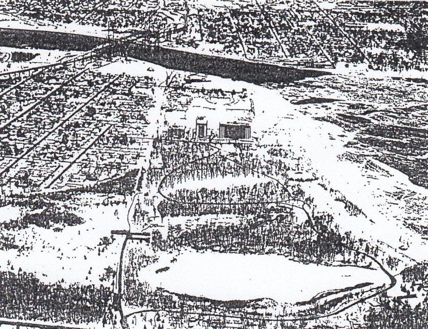
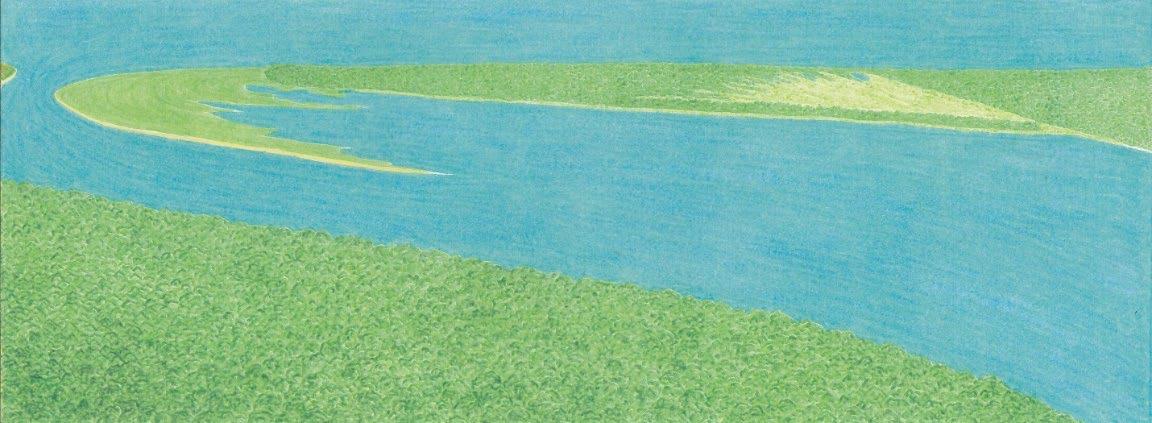
The drawing below is based on the features shown on Map A4. It depicts the view looking north at the Point Edward – Canatara area in 1800. The forest in the foreground is where downtown Port Huron is located today. It shows how the gravel and spit deposits, by filling in the wide river entrance, have displaced the river westward and created a deep, narrow channel with rapids at its head.
Port Huron, Sarnia Bay and Point Edward: c1800
View looking north at the Point Edward Spit about 1800 with the narrow head of the St. Clair River on the left and the marsh leading up to Lake Chipican on the right.
License of Occupation in the Point Edward Military Reserve
(NOTE: The page quoted below is from the Lambton County Archives)
“To Malcom Cameron, Township of Perth, Lanark County, in the District of Bathurst, merchant. That a parcel of land in the township of Sarnia, in the county of Kent in the W.D. being the rear of the Government or Military Reserve at the rapids of the River St. Clair, and known as Point Edward, that is to say; In the limit between the said reserve and lot No. 69 fronting upon Lake Huron, and at the distance of 20 chains from the water’s edge of the said lake, and then parallel with the lake and River St. Clair always at the distance of 20 chains therefrom, till intersected by a line produced from the rapids in the River St. Clair, then following the edge of the marsh, about south 88 degrees , 7 min. east 40 chains more or less to the lands granted Henry Jones., Esq., then northerly along the front of said lands to the northern limits of allowance for road in rear of lots fronting on lake Huron, then south 88 degrees, 7 min., east 8 chains more or less to the eastern limit of the said reserve, then north 1 degree, 53 minutes east 90 chains, more or less, to the place of beginning. Containing 400 acres.” See Map A2 below.
Order in Council, 27th April 1837
Licence of Occupation for 3 years with privilege of purchasing at the present valuation of the Commissioner of Crown Lands, should be, the Grantee, within that period, erect a grist and sawmill thereon.
To His Excellency, the Right Honorable Sir Charles Bagot, G.C.B. Gov. Gen. of British North America.
Report of a Committee of the Executive Council. Present The Hon. Wm. Sullivan in the chair. Wm. Daly and Wm. Harrison, on a letter from Lieut. Col. Ward, Royal Engineers. May it please your Excellency.
On a letter from Lieut. W.C. Ward, Royal Engineers Commanding in Canada, relative to the application of Malcom Cameron, Esquire, for a renewal of a license of Occupation during pleasure, or for a grant, of the Military Reserve at Point Edward in the Township of Sarnia. The Committee finds that the Minute of Council permitting Mr. Cameron to purchase, was made in ignorance of the land applied for, being a Military Reserve, or necessary for defence. Under the report of the Commanding Officer of the Engineers, the land cannot be disposed of, or a license of occupation given, or renewed, and although in strictness Mr. Cameron should not have incurred expenses in contemplation of a purchase not completed yet, under the circumstances, the Committee think it fair, that he should be reimbursed his outlay, and they recommend that his claim be submitted by the Government to the consideration of the Legislature at its next session. All which is strictly submitted, by Order, W. Sullivan, Chairman, 28th Feb. 1842.”
Malcom Cameron’s License of Occupation in The Military Reserve: 1837 – 1842
Cameron came to “The Rapids” in 1835, primarily to harvest the huge forests of hardwood trees in the area. He purchased and leased large tracts of land in Sarnia Township, established sawmills to cut the logs, and built ships to transport the lumber to Britain.
As recorded above, in 1837 Cameron obtained a License of Occupation for 3 years on the 400acres of the Military Reserve outlined in red on Map A2. He was also granted the privilege of purchasing this parcel if he erected a grist or sawmill in it within the 3-year period. The only section of the future Canatara Park situated in this parcel is the 9.2-acre triangular property that Sarnia obtained in 2000 as shown on Map L4 above. In 1837 there were very few trees in this property since most of it was in the marsh-filled lagoon.
Also recorded above is the 1842 report informing Cameron that his 1837 License of Occupation should not have been issued since it was in the Military Reserve. His application to renew the license was therefore denied. Whether he ever logged any of this parcel is unknown.
Notes Regarding Map A2
This rudimentary survey map, which is from the Lambton County Archives, has no date, but was probably made in the 1830’s or 1840’s. Over the years additional information, such as the location of various Licenses of Occupation has been written on the original map.
Notice that the configuration of the Point Edward spit (colored yellow) is similar to that depicted on Map A1. Only the portion of Cameron’s 1837 License of Occupation (outlined in red) that was located on the spit contained trees; the remainder was located in the marsh-filled lagoon and Sarnia Bay. Also notice that the map shows the location of Fort Gratiot, built in 1814 on the American side of the rapids as noted above. Furthermore, notice that the marsh stretching from Lake Chipican to Sarnia Bay was only separated from Lake Huron by the narrow “neck” of the spit. This led early settlers to assume that the marsh had recently been the location of a channel of the St. Clair River. However, the
fact that the neck consisted of large sand dunes overlying a thick gravel deposit, as explained above, refutes this assumption.
Map A2 – Survey Map
Proposed Fortifications in the Military Reserve
1845 – 1855
In 1845 James Polk became the America president and as part of America’s “Manifest Destiny” he demanded that the entire Oregon Territory in western North America, including what is today the southern half of British Columbia, be annexed by the United States. To counter this “saber rattling” British officials considered constructing additional fortifications adjacent to the American border, including a fort at Point Edward. The following item concerning this matter, appeared in the Port Huron Observer on August 23, 1845.
“The Earl of Cathcart and suite arrived in Port Sarnia last Sunday and remained until Tuesday morning. The Earl is the Commander-in-Chief of the British forces in Canada, and we learn that his visit was preliminary to the erection of a fort somewhere in the vicinity of Port Sarnia – it is said at Point Edward. Should this site be selected, the fortification will be directly opposite Fort Gratiot.”
In 1846, Polk, who was also involved in a dispute with Mexico, agreed to compromise on the Oregon boundary by accepting the 49th parallel and yielding Vancouver Island to the British. (The British had sent a squadron of naval ships to Vancouver Island to enforce this compromise.) Since the Oregon boundary dispute was settled peacefully, no fort was built at Point Edward in the 1845-46 period.
Nine years later, on October 19, 1854, the Sarnia Observer noted that:
“We have just learned that two Military Engineers arrived here on Friday last, bringing with them the necessary apparatus for surveying and laying out the Military Reserve at Point Edward, immediately above our town, preparatory to the erection od a fort thereon.”
As explained in Volume 2, this survey was in response to a request by Gzowski & Co. to purchase most of the Reserve for railway purposes. The survey carried out in 1854 reduced the original Reserve to a 41-acre circular plot known as the “Ordnance Reserve”, located where the water treatment plant and the western portion of the Sarnia Yacht Club Basin are today. (See Map J, Volume 4). According to Orlo Miller (The Point p25), the plans for a fort consisting of a round tower were issued in August 1855, but no fort was ever constructed because relations with the United States remained relatively peaceful.
Notes For Map A3
Summary of Streets’ Sale to Durand, 1841
“A Memorial of an Indenture of Bargain & Sale made 8, September 1841 between Samuel Street of the Township of Stamford in the district of Niagara and George Durand of the Township of Sarnia in the Western District.
Whereby Samuel Street in consideration of the sum of 565£ (pounds) and 10 shillings paid by George Durand grants onto Durand, his heirs and assigns forever, all these certain parcels of land being in the Township of Sarnia containing 754-acres and being composed of lots 22 & 23 in the VII concession and lots 55, 65, 66, 67, 68 & 69 in the IX or front concession on Lake Huron. (Marked green on Map A3).
To have and to hold, under the reservations, limitations and conditions expressed in the original grant from the Crown.”
Note: Later in the 1840’s Malcom Cameron purchased from Durand lot 22 and those parts of lots 23, 65, 66, 67 lying south and east of Errol Road. (Colored pink on Map B, Volume 2). In March 1847, Alexander Vidal surveyed the parts of lots 23, 67, 68, & 69 lying west of Errol Road into six so-called “park lots.” By the early 1850’s Cameron and Vidal owned park lot 3, W. Stocks lot 4, and A. Slocum lot 5. (See Map B, Volume 2).
Durand may have logged some of this property, although most of the northern portion of lots 67, 68, & 69 in the Canatara area consisted of marsh, and drawings and maps from the 1860 – 1900 period show that the ridges in this area were still covered with trees. Therefore, he probably cut few if any trees in the Canatara area before he sold it in 1853, as recorded above.
In the 1850’s a road was constructed from Errol Road to Lake Huron on the line between lots 66 & 67 in the 9th concession. At that time, it was known as Seward Road since it ran adjacent to Seward’s Pond, as Lake Chipican was often called. Later in the 1900 – 1950 period it was known as Woodrowe Road when the Woodrowe Beach Resort was located on Lake Huron, as shown on Map E3 in Volume 3. Now it forms the northern section of Christina Street in Sarnia.
Early Settlers in the Point Edward – Canatara Area 1827 – 1857
Although Henry Jones had a license to fish at the Military Reserve in the 1827 – 1834 period, he lived in the Bright’s Grove area. His fishery is shown on Mount’s 1829 survey located on the Lake Huron shoreline adjacent to where the Sarnia Yacht Club basin is today, as marked on Map A. Likewise, as recorded above, Malcom Cameron had a license to log the trees on a section of the Military Reserve in the 1837 – 1842 period, but he lived in Port Sarnia, as ‘The Rapids” began to be called in 1836. Only three settlers actually lived in the Point Edward – Canatara area in the 1827 – 1857 period. They were John P. Slocum, Henry L. Seward and John Robinson (sometimes spelled Robson.). According to most accounts, in 1838, Slocum & his brother-inlaw, Seward, came from New York State to Point Edward to harvest the abundant fish just as the
native people had done for several thousand years. Slocum leased the fishing grounds at the Military Reserve for an annual rent of 300 pounds. He & his family lived in a home near what was then known as the Crescent Fishing Grounds, located just north of where the Blue Water Bridge is today. Seward, on the other hand lived close to Lake Chipican, as the following two references reveal.
“Henry L. Seward took up the land around Lake Chipican when he came to Canada from the States about 1840. Later he moved further out along Lake Huron and his decedents eventually moved to Corunna. But he had stayed long enough on the edge of Point Edward for Lake Chipican to become so well known as Seward’s Pond that the name clung to it well into this century.” (Jean Elford, Sarnia Gazette, September 13, 1972, p12).
Lake Chipican “was always called Seward’s Pond. Mr. Seward’s house, on the shore nearby, was the only one for a long distance in either direction.” Charlotte Nisbet, Sarnia Observer, August 5, 1945, p5).
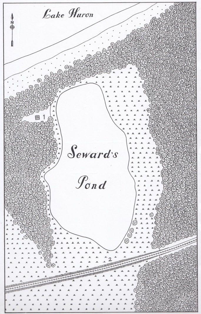
During an interview with Fred Prudence in 1990, he mentioned that “old timers” had told him that Seward’s house – which they indicated was little more than a shack – was located on the northwest side of Lake Chipican about where the cattle quarantine station was situated in the 1880’s. (See Map A11 below).
Although Seward never owned any land on the site of the future park, he is the only settler known to have lived in the Canatara area during the 1827 – 1857 period.
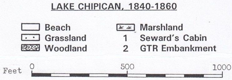
Map A11 was drawn in 1993 and shows the area around Seward’s Pond in 1860, just two years after the GTR embankment was constructed through the marsh near the southern end of the pond. This embankment is where the road to the Children’s Farm is now located. Seward’s house, which was probably abandoned by 1860, may have been located near the northwest corner of Lake Chipican, as depicted on the map. Seward’s Road was just off the right edge of the map, where Christina Street is today.
Map A11
In 1849, John Slocum died & his son Henry L. Slocum continued the fishing business in partnership with Samuel Hitchcock. Hitchcock’s son, Marcus, who was also a fisherman at Point Edward, recalled the difficult conditions at this fishery in the 1840’s & 1850’s, as recorded in the following two Observer items.
“Fishing was one of the big industries of that time. None of the conveniences of today were available to the men who wrested a hard-won living from the teeming waters of the lake and river in the spring and in the fall. The old seine nets, one end attached to a cumbersome rowboat, out as far from shore as the nets would permit, and hauled along the shore and by horse, scooped the fish from their freshwater home into the waiting baskets of the fishermen to be transported to the Port Huron fish market and thence to the more populous cities of Eastern United States. Sarnia was unknown then, but Detroit, Cleveland, Toledo and scores of other cities enjoyed the fish from this port. Sturgeon, one of the prize fish of the lakes today, was a useless catch in those days Then they were stacked along the shore and sold to any Indian who wanted them for fertilizer for ten cents a load. Millions of dollars’ worth of this fish was left to rot for want of a market.”
July 29, 1936, p15
Slocum and Sam Hitchcock “got in from two to three hauls of the nets each night and the catch would be in the neighbourhood of a ton and a half to two tons for each net.”
July 18, 1925
The commercial fish at that time were primarily herring, pickerel and whitefish. They were packed into brine-filled barrels and shipped to the big American cities. Smith’s Gazetteer of 1846 recorded that upwards of 1,000 barrels of fish were exported annually from Point Edward.
Concerning John Robinson, the third early settler at Point Edward, Jean Elford wrote: “… in 1840 Malcom Cameron had succeeded in getting John Robson a 12-year lease on the east side of the village Cameron had Robson come from Perth to assist him in his temperance work. To gain a living for his very large family, Robson farmed at the Point, fished in the river, and butchered and sold his livestock. His wife sold her butter and eggs to the soldiers at Fort Gratiot and to Port Huron merchants. It was a lean living and Robson left for Sombra in 1850. He returned to Sarnia in 1852 to become the first jailer.”
(Canada West’s Last Frontier, p114)
During the 1840’s these three settlers and their families had the point all to themselves. Undoubtedly, they were familiar with all the landscape features in the Point Edward – Canatara area described above. Much like the native people before them, they swam in the lake, climbed the big sand dunes, caught frogs and turtles in the marshes and harvested the acorns in the “forest of scrub oak”, as Marcus Hitchcock called the oak woodland. However, by the 1850’s John Slocum was dead, and both Seward and Robinson had moved away. So, the three earliest settlers were not around in 1858 when the construction gangs of the Grand Trunk Railway began the process of transforming the natural environment into the largely human-made one that exists today. In Volume 2 we leave the world that the native people, the European explorers and the first settlers knew and enter a new age – the age of the steam engine, the railway, and the Industrial Revolution.
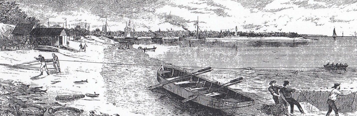
The drawing (below) of the Point Edward fishery is from the January 1, 1876, issue of the Canadian Illustrated News. It shows the view looking west from the lakeshore where Henry Jones had his fishery, as marked on Map A. In the foreground are several of the features mentioned by Marcus Hitchcock including the men hauling in the seine net, the cumbersome rowboat, and the baskets of fish. On the beach, just below the fish shanty, two men are using a hand-operated winch to haul in a net filled with fish. In the background, notice that a small dark tugboat is towing a row of schooners through the rapids at the head of the river into Lake Huron. In the 1840’s before there were steam-powered tugboats, Marcus Hitchcock noted that the schooner captains would pay John Robinson to use his oxen to tow the sailing craft up through the rapids.
Selected References for Volume 1
1. History of Native People
Chief Jacobs, Sarnia Observer, December 8, 1926, p9
George, P. Sarnia Observer, July 2, 1949, p11
Heidenreich, C.E. “Mapping the Location of Native Groups – 1600 - 1760”
Mapping History 2. 1981, pp 6-13
Needs – Horwarth, S. “Animals and Archaeologists” Before Ontario – pp 112 – 123
Plain, D.D. – Ways of Our Grandfathers, 2007
Prowse, S.L. “Much Ado About Net Sinkers” Ontario Archeology. pp 85 -86, 69-96, 2008-09
Fishery on Lake Huron near the head of the St. Clair River, c1875. The Fort Gratiot lighthouse is in the background on the American shore.
Sarnia Observer, August 21, 1999 – Section C, “Aamjiwnaag”
2. Early European Period: 1679 – 1829
Charlevoix, P.F. Histoire et description general de la Nouvelle France – 1744
Gentilcore, L & Head, G. Ontario’s History in Maps, 1984
Gross, J. The Mapping of North America: Three Centuries of Map Making: 1500- 1860, 1990
Heidenreich, C.E. “Mapping the Great Lakes: The Period of Exploration, 1603 – 1700. Cartographica Vol 17 – 1980 pp 32-64
Mapping the Great Lakes: The Period of Imperial Rivalries, 1700 – 1760” Cartographica Vol 18, 1981 pp74-109
Hennepin L. – Description de la Louisianne – 1683
Lahontan, Nouveaux Voyages – 1703
Lajeunesse, E.J. (ed) The Windsor Border Region 1960
Mansfield, M.J B. History of the Great Lakes. 1899
Michigan Pioneer Collections – Vol 15, pp 400-401
Mika, N. & Mika H. – The Shaping of Ontario 1985
Parker J. (ed) Carver’s manuscript Journals: 1766 – 1770, 1976
Williams, M.L. (ed) The 1820 Narrative Journal of Travels of Henry Schoolcroft. – 1953
Cole, L.J. “The Delta of The St. Clair River” Geol. Surv. Mich. Vol 9, 1903, pp10-11
Fitzgerald, W.D., Janicki, E, & Storrison, D.J. – Sarnia-Bright’s Grove Area, Southern Ontario, Ontario Geological Survey, Preliminary Map. P2222, 1979
Goldthwait, J.W., “An Instrumental Survey of the Shorelines of the Extinct Lakes Algonquin & Nipissing in Southwestern Ontario” Geol. Surv. Can. Mem 10, 1910
Hough, J.L. “The Prehistoric Great lakes of North America” American Scientist. Vol 51, 1963, pp84-109
Johnson, D.W. “Shore Processes and Shoreline Development” 1919
Leverette, F. & Taylor, F.B. “The Pleistocene of Indiana & Michigan and the History of the Great lakes”; U.S/ Geol. Surv. Memo 53, 1915
Shwartz, M.L. Spits and Bars 1972
Taylor, F.B. “The Second Lake Algonquin” Am. Geol. Vol 15, 1895 pp162 – 179
Wrightman, W.R. “The St. Clair Delta” M.A Thesis, Department of Geography, Western University, 1961
History of St. Clair County, Michigan – 1883
4. Activities in the Point Edward – Canatara Area: 1827 – 1857
Elford, J. Canada West’s Last Frontier 1982
Hodgson, D. History of Sarnia Township 2018
Lauriston, V. Lambton County’s 100 Years 1949
Miller, O. The Point 1978
Phelps, E. Sarnia: Gateway to Bluewaterland 1987
Phillips, G.C. Lambton: An Illustrated History of the County 1999
Smith, G. & Smith L.K. “A History of Sarnia to 1900
Smith, W.H. Canadian Gazetteer, Canada West 1846
Note: More references, as well as maps from the 1656 – 1833 period are in the addendum.