Newtown Pike
Extension
Corridor Plan
Lexington, Kentucky

August 22, 2002
As amended per Planning Commission conditions of November 18, 2002

Newtown Pike
Extension
Corridor Plan
Lexington, Kentucky
August 22, 2002
As amended per Planning Commission conditions of November 18, 2002
Section I
Background Information
Section II
Plan Elements
Section III
Implementation
Appendix A: Maps
Map 1Study Area with Road Layout
Map 2Subareas
Map 3Interface Areas
Map 4Development Patterns
Map 5Topography
Map 6Drainage Conditions
Map 7Hazardous Material Concerns
Map 82000 Census Tracts
Map 9Existing Land Use
Map 10Future Land Uses from Comprehensive Plan
Map 11Existing Zoning
Map 12Existing Zoning Conflicts with Future Comprehensive Plan Land Use
Map 13Roadway Functional Classification
Map 14Accessibility Features
Map 15Off-Street Parking Locations
Map 16LexTran Routes
Map 17Key Existing Pedestrian Routes
Map 18Sanitary Sewer Lines
Map 19Curb and Gutter Condition
Map 20Community Facilities
Map 21Historic Resources
Map 22Planned Circulation Framework
Map 23Planned Land Use
Map 24Planned Land Use and Key Improvements
Map 25Parkway Alternates and Cross-Section Locations
The following appendices to the plan are available as separate documents:
B.Planning Area Character Analysis
C.Exterior Building Conditions Report
D.Socioeconomic Conditions Report
E.Economic Development Opportunities Report
F.Storm Detention Analysis
Newtown Pike Extension Corridor Plan Lexington, Kentucky
Credits
City Staff:
Andrew Grunwald
Lexington-Fayette Urban County Government
Division of Engineering
200 East Main Street
Lexington, Kentucky 40507
Phone: 859-258-3597
email: agrunwal@lfucg.com
Henry Jackson
Lexington-Fayette Urban County Government
Division of Planning
200 East Main Street 6th Floor #601
Lexington, Kentucky 40507
Phone: 859-258-3174
email: hjackson@lfucg.com
Advisory Committee
Steve Austin - Bluegrass Tomorrow
Dr. Jack Blanton - University of Kentucky
Betty Boyd - Pralltown Neighborhood Association, Carver Center
John Carr - Deputy State Highway Engineer, Kentucky Transportation Cabinet
Bob Bayert - Lexington-Fayette Urban County Government - Division of Engineering
Dick DeCamp - District 3 Council Member
Necia D. Harkless - Western Suburb
Bill Johnson - Historic Western Suburb Neighborhood Association
Chris King - Lexington-Fayette Urban County Government - Division of Planning
John Kiser - Fayette County Schools
Bill Lear - Stoll, Keenon & Park
Leigh McKee - Woodward Heights Neighborhood Association, LLC
Melinda Rockwell - Representative Corridor User
Felix Ross - Georgetown Neighborhood
Dave Uckotter - Lexington-Fayette Urban County Government - Division of Engineering
Casey Wilson, III - Lexington-Fayette Urban County Government - Division of Code Enforcement
David G. Wilson - Bracktown Neighborhood Association
Rev. Deborah Whitmer - Nathaniel Mission
Willie H. Whittamore, Jr. - Kentucky Transportation Cabinet District 7
Jack Wiggington - District 2 Council Member
Jim Woods - LFUCG Transportation Division
Planning Team Members:
Winter & Company - Planning
American Consulting Engineers - Roadway Design/Planning Systems
Third Rock Consultants - Environmental Assessment
Lane Consultants - Economic Consultant
Preston•Osborne - Public Relations Consultant
Helen Powell - Historic Consultant
Jean Scott - Strategies for Livable Communities
Sherman-Carter-Barnhart - Landscape Architects
The Newtown Pike Extension Corridor Plan defines a vision for the collection of neighborhoods flanking the proposed extension of Newtown Pike. This includes continuing rehabilitation of existing housing and development of new residential infill to accommodate residents, as well as a diverse range of new households. Commercial development expands services to the planning area, as well as the downtown in general.
In addition, some new developments include mixes of residential and commercial functions; and, in limited cases, special industrial activities appear. Historic properties are preserved and adapted to new uses that enliven the neighborhoods, while parks and community centers provide a range of social, cultural and recreational resources for residents.
Circulation improvements occur with bicycle lanes along the parkway and connections to pedestrian trails, as well as the enhanced auto service resulting from the extension of Newtown Pike itself, which is to be designed as a parkway. The transit system also can be improved by the parkway. Streetscape designs highlight major intersections; and other streets see improved sidewalks, curb and gutter.
First, a series of general strategies related to economic development is provided. Then, a series of categories that address a range of land uses follows. These include residential, commercial, industrial and institutional facilities. Finally, strategies for circulation systems, environmental conditions, cultural resources and streetscape are presented.
General land use and key improvements for residential, commercial and industrial development are illustrated on Maps 23 and 24, in Appendix A.
This section summarizes key strategies for achieving the objectives set forth for the planning area. It lists key concepts for land use, redevelopment and implementation of plan recommendations.
Market opportunities exist for providing more services in the area, and the advent of the parkway will further strengthen this condition. Key strategies are:
•Employ an “evolving markets” view that coincides with the different phases of plan implementation.
•Promote initial development directions that respond to current market conditions.
•Design long-range development plans that anticipate market trends.
•Reinforce desirable trends with public support programs.
•Keep the broader downtown economic goals in mind.
•Work with local lenders to provide financing for improvement projects.
Continuing to improve existing housing stock and encouraging compatible new residential construction are fundamental plan concepts. Key strategies are:
•Use a mix of programs to efficiently provide more affordable housing.
•Promote development of new housing to coordinate with completion of the parkway.
•Facilitate market rate housing through assistance with land assembly and investment in infrastructure.
•Promote residential development with educational programs and model design prototypes.
•Adopt design standards in the Residential Infill and Redevelopment Study that promote design compatibility with existing neighborhoods.
•Promote housing development in areas where the 2001 Comprehensive Plan Update calls for it.
•Promote development of affordable housing to retain existing residents in the neighborhood.
Encouraging new commercial development that serves the neighborhoods in the planning area is a priority. Strategies include:
•Accommodate short-range development that meets design compatibility and land use objectives.
•Maximize opportunities for development to follow “long-term best uses” that meet longrange plan objectives.
•Assist with land assembly where resulting projects yield results “greater than the sum of the parts.”
•Promote “critical mass” developments that will create a climate for further investment in the area.
•Focus development on major corridors where it can also draw upon a larger trade area.
•Promote mixed use projects as transitions to residential neighborhoods and to build in more local market demand.
•Support the use of improvement assessments to facilitate coordinated development.
•Encourage a variety of uses, particularly those that will provide services to the neighborhoods within the planning area, as well as for downtown in general.
•Welcome businesses that provide jobs to area residents.
Land Use Strategies for the southern edge of Historic South Hill neighborhood are to extend residential development and provide some mixed use facilities along Broadway. (This plan reflects one roadway layout option for the Newtown Pike Extension in which Broadway and Bolivar align directly and in which historic properties are retained.)

Redeveloping industrial properties to new uses that serve the planning area is a priority. In some cases, adapting these sites for new light industrial trends is recommended. Strategies are:
•Promote adaptive reuse of existing industrial buildings.
•Support industrial development that looks to new trends in industrial uses.
•Focus industrial development where it complies with 2001 Comprehensive Plan Update policies.
•Promote industrial development that will provide jobs for residents within the planning area.
Institutional facilities include churches, community centers and parks. Continuing to support improvements to these resources and their operators is recommended. Key strategies are:
•Support programs that will optimize the use of existing community centers and local churches that provide services in the planning area.
•Locate new institutional facilities in the planning area where they will support other urban design goals.
•Nurture the use of nongovernmental organizations, including Community Development Corporations, to develop housing.
•Improve existing parks in the area and expand them where appropriate.
•Design parks and greenways to assist with regional drainage strategies where feasible and to promote pedestrian connections.
Improving circulation for all modes of transportation is a primary objective of the Newtown Pike Extension. Other system improvements are coordinated with these objectives. Key strategies are:
•Provide improved pedestrian and bicycle links to key resources and destinations.
•Coordinate pedestrian and bicycle system improvements with regional trail system plans.
•Enhance auto access to sites where development is targeted.
•Enhance transit accessibility.
Rehabilitating sites for future development through environmental cleanup is a priority. Strategies are:
•Use environmental cleanup programs to attract development to key sites.
•Link cleanup activities to the Newtown Pike Extension as much as possible.
Historic properties should be maintained to serve the community. Key strategies are:
•Promote the use of preservation incentive programs, including tax credits.
•Assure that preservation design guidelines are appropriately tailored to the individual historic districts.
•Consider preservation options in re-zoning actions.
•Develop the conservation overlay tool proposed in the Residential Infill and Redevelopment Study to protect neighborhoods that are not historic districts. Apply it where residents seek such protections.
•Promote preservation awareness through tours, brochures, etc.
•Establish an interpretive marker system to convey the heritage of the area.
•Give priority to reuse of historic buildings when locating civic functions in the area.

Streetscape improvements are planned to encourage pedestrian and bicycle activity and to signify entries into the area. Key strategies are:
•Develop gateways that highlight entries into the downtown area.
•Develop a streetscape design “vocabulary” that can help to establish an identity for all of the downtown area.
•Provide for special “accent” features that can be used to distinguish individual neighborhoods within the planning area.
The key concepts for the Corridor Plan are organized along major circulation corridors and around public facilities. Of these, the Newtown Pike Extension is paramount. It serves as the primary organizational spine. Major development sites, gateways and intersection improvements, neighborhood entry points as well as “neighborhoods” are connected by the extension. The circulation elements and streetscape framework are shown on Map 22, “Planned Circulation Framework.”
Essentially, commercial uses are concentrated along major circulation routes, including Broadway and Manchester. Multifamily housing then serves as a transition to single family neighborhoods in some cases, and institutional facilities serve as focal points in several of the neighborhoods. Existing residential neighborhoods continue to improve while maintaining their distinctive features. New buildings provide space for new residents and businesses, and are designed to be compatible with this established context.
In terms of circulation, the Newtown Pike extension itself improves traffic flow and provides access from the planning area to services located downtown and in other parts of the city. Bicycle lanes and
A concept for the development of a gateway at Main and Newtown Pike includes construction of a new civic building on the southwest corner.
Streetscape enhancements are identified as key improvements on Map 24, in Appendix A. These include special landscape designs at selected intersections, as well as designs along certain streets.
sidewalks on the parkway improve these alternative circulation modes, and opportunities for enhanced public transit also are available.
The framework concept identifies policies for land uses in a series of subareas. (The subareas are defined on Map 2.) The related strategies for land uses are illustrated on Map 23, “Planned Land Use.” In general, well established residential neighborhoods are to be protected and reinforced. Actions in these areas focus on improving existing community facilities and promoting compatible rehabilitation and infill. Subareas where such policies apply include historic districts and other older, well established residential neighborhoods.
In other areas which are in transition, recommendations focus on adaptive reuse and redevelopment with uses that will help to meet overall goals for the planning area and serve the downtown as a whole. Several commercial and industrial areas are included in these policies, as well as some residential areas where significant reinvestment is needed.
The land uses shown in Map 23 are subject to further refinement in the 2001 Comprehensive Plan Update adoption process, based on public input, and the application of specific site conditions at the time of rezoning.
In historic districts, promoting rehabilitation of existing residential properties, and assuring that compatible infill occurs on vacant lots where they exist, are key goals. Demolition of historic structures should be avoided, and incompatible land uses should not be introduced. This applies to:
• Woodward Heights
• Western Suburb
• Historic South Hill
These are neighborhoods which convey special identities within their boundaries and have a sufficient amount of existing housing stock to function as distinct neighborhoods. In these areas, promoting neighborhood conservation is an objective. Rehabilitation of exist-
ing homes should be encouraged, and compatible new infill should occur. This applies to:
• Speigle Heights
• Pralltown
• Irishtown
These are areas where substantial residential stock exists, but larger vacant parcels or underutilized sites also occur. In some cases, the edges of the neighborhoods are clearly defined; in others, the definition is less clear and some “transitional” sites lie along their borders. Reinforcing the established residential stock is a goal, where feasible, as is increasing housing supply. Compatible infill is foreseen, both in single family and multifamily arrangements. This strategy applies to:
• The eastern (upper) portion of Davistown
• The southern extension of Historic South Hill Neighborhood/UK
Finally, the western (lower) portion of the Davistown area is identified as the location of substantial redevelopment as an “urban village.” This concept would eliminate incompatible industrial uses and reframe the residential neighborhood around a park and community center. It includes a mix of single family, two-family and multifamily residential, with a diversity of market rate and affordable types. A re-designed park serves as a focal point, and new neighborhood commercial services flank its edges.
Commercial redevelopment is focused along major circulation routes and in places where industrial uses are no longer viable. Major commercial development is proposed along Broadway, near the new intersection with Newtown Pike. This would include services, such as a grocery, as well as other supporting retail. Mixed use developments, including business and residential space, are also recommended along this corridor.
Special opportunity sites are specifically targeted for redevelopment, to give identity to individual neighborhoods and provide needed services. These are conceived to meet broader markets and needs, for downtown in general, as well as the planning area. Multifamily housing is introduced at some of these sites to increase housing supply and to act as a transition to single family neighborhoods.
The term “urban village” is used in this plan to describe the concept for a revitalized neighborhood that includes a mix of residential uses. Much of the housing would be in single family structures, although some two-family and multifamily units would also occur, to help foster a diversity of residential options. These also would include a mix of affordable and market rate types. A park serves as a recreational amenity, and a community center would be an anchor of activity. Trails and walkways provide access to nearby commercial services and jobs.
The basic strategy for development framework is illustrated on Map 23, “Planned Land Uses.”
In the concept illustrated here, new commercial development is envisioned along Broadway at the intersection with Newtown Pike. Multifamily residential would serve as a transition from this to single family residential beyond.

Phasing out industrial uses within some subareas is also recommended. These lands are now better suited for commercial and mixed use development in order to make a stronger transition between residential and remaining industrial uses. Properties along the western edge of Broadway, and south of the Newtown Pike Extension, are in this category. In some cases, light industrial activity that includes related residential units is proposed. This applies to properties along Manchester Street.
Automobile Circulation Strategies
Major auto circulation, pedestrian and bikeways routes are important parts of the overall plan framework. At its core, the parkway is a major circulation corridor. It will help to relieve congestion and improve access to services for neighborhood residents. Broadway, Versailles and Manchester also remain major routes. Improving circulation and access along these corridors is a priority. These serve the city at large, as well as the planning area.
Within individual subareas, traffic is “calmed” (speed reduced) by managing access points, controlling turning movements and generally designing streets for speeds and volumes compatible with the planned land use mix.

A
Tree lined street edge
Landscaped median
A key objective is to promote the use of alternative modes of transportation, and thereby reduce automobile miles traveled within the planning area. As a means of doing so, key pedestrian and bike routes are enhanced and others are developed. The primary ped/bike route runs along Newtown Pike Extension itself. This route is a “green circulation corridor,” which links a series of commercial and residential infill sites, along with pockets of open space. Designated bike lanes will be included and pedestrians will have sidewalks with landscape buffers. This will encourage a reduction of automobile trips and improve access to services. Key recommendations in this regard are:

Streetscape enhancements along Manchester would provide a framework for investment. Redeveloped warehouses and new live/work facilities are illustrated.
•Link the gateway at Main and Newtown with the neighborhoods within the planning area, and pedestrian/bikeway access to downtown via Main Street.
•Develop a trail link between Lexington Center parking and proposed redevelopment of Manchester. (This later becomes a part of the Town Branch Trail System.)
•Link parks and community centers with improved pedestrian routes.
•Provide a pedestrian underpass between Southend Park and the northern portion of Davistown.
•Pedestrian/Bikeway utilization of “possibly to be acquired” railroad right-of-way between Scott Street and its intersection with Broadway.
•Provide a pedestrian link from DeRoode to the Versailles and Pine Street intersection.
Public transit is provided through the LexTran bus system. The parkway will provide opportunities for enhancing the organization of bus routes in the area and it will include sites for potential bus stops. Streetscape improvements in the area, including the construction of new sidewalks and landscaping others, will encourage walking to bus stops.
A fundamental streetscape element is that the Newtown Pike Extension is being designed as a parkway with a landscaped median. The planned character of the new parkway is to develop an urban street that reflects the traditions of the surrounding city. At the same time, it will provide a convenient and attractive setting for local residents and those traveling through the area. In addition, major streetscape enhancement concepts are planned and are also diagrammed on the “Planned Circulation Framework” map. These include a series of gateways, which serve as major entry points, both into downtown at large and into the planning area specifically. Other key intersections where residents make turning movement decisions are highlighted as well. Finally, some streets are targeted for streetscape enhancements along extended blocks that are directly related to the local proposed land uses. The streetscape system is organized in a hierarchical strategy. Some intersections are considered “gateways” and others are “major intersections.”
The major gateways include special landscaping, entry signs and street furniture. They serve to identify key entry points and also to provide a reference point for adjoining development.
Gateway Locations:
• The intersection of Main and Newtown Pike
• The intersection of Versailles Road and Newtown Pike
• The intersection of Broadway and Newtown Pike
• The intersection of Limestone and Newtown Pike
Major Intersections
Key intersections convey a streetscape palette similar to that of the gateways, but at a lesser scale. Public information at these points identifies resources within the abutting neighborhoods. Decorative crosswalks are also included.
Key Intersection Locations:
• Newtown Pike and Manchester Street
• Newtown Pike and Merino Street
Linear streetscapes include street trees, sidewalks, curb and gutter. Decorative paving in crosswalks is also included. Streetscapes are also visually related to the gateways and key intersections.
Linear streetscape locations:
• Along Main Street
• Along Manchester Street
• Along Broadway
• Newtown Pike Extension
• Along Bolivar
Public funds should be used to help implement the plan with the following principles:
•Maximize the leverage of public funds.
•Use public funds wisely, to stimulate private investments.
•Schedule infrastructure improvements to coincide with other construction in the area.
•Be flexible enough to follow private investment with public funds.
•Coordinate public investments among different agencies and departments.
Implementing the plan requires a cooperative effort for a collaboration of public and private entities, including a special Community Development Corporation, existing agencies and non-profit affordable housing providers. For-profit developers also will play an important role. State and federal agencies also will be of assistance. Finally, the Urban County Government should be proactive and take the lead role in stimulating development that complies with the principles of the plan.
The schedule for the construction of the parkway is a major influence on implementation, because many key improvement projects are related to conditions that will result from the road. Development of some abutting properties will occur most likely after the road is completed; while other projects, such as development of affordable housing related to potential impacts, must be addressed early in the process.
This document constitutes a Corridor Plan for the neighborhoods flanking the proposed Newtown Pike Extension in downtown Lexington, Kentucky. The Lexington-Fayette Urban County Government uses this approach to provide policies for treatment of a collection of neighborhoods that are geographically related. In this case, the neighborhoods are those that are near the new portion of Newtown Pike that will run from Main Street south to Broadway and Limestone Street. The plan was developed in conjunction with studies to refine the alignment of the road. This is unusual, in that the research associated with each of these projects has been used to supplement information for the other.
This joint effort yielded detailed studies on environmental and socioeconomic conditions that follow guidelines for the environmental assessment process, while also complementing the Corridor Plan. In some cases, it was possible to make adjustments in the road alignment to better facilitate desired redevelopment along its edges or to provide access to specific neighborhoods. Even so, it is important to note that further modifications to the road alignment may occur in the more detailed design and engineering phases that will follow. Therefore, it is important to note that the alignment illustrated on the planning maps in this document may vary to some degree from what is actually constructed. The alignment shown is basically that adopted by the Council of the Urban County Government as a part of the scoping process for the road design.
It is also important to note that this plan covers a large geographic boundary. This has been inspired by the scale of the Newtown Pike Extension itself, reflecting the issues and opportunities associated with that project.
The planning area is a southwestern extension of the core of downtown Lexington. The eastern limits of the planning area follow portions of South Limestone Street, while the southern limit lies along Virginia Avenue. The Southern Railway main line generally defines the western boundary, while the northern boundary line is a varied progression around the southern perimeter of Lexington Cemetery, Georgetown Street and Maxwell Street. (The planning area boundary is shown on Map 1 in Appendix A.)
This document draws upon policies set forth in the 2001 Comprehensive Plan Update, as well as materials from a 1980 Small Area Plan that focused on Irishtown, Davistown and Woodward Heights. A variety of other planning documents also supplied information, including a South Broadway Corridor Plan Case Study (1997), the Town Branch Greenway Plan (1999), and the Year 2025 Transportation Plan Update. In addition, socioeconomic information was provided as a part of the study of the Newtown Pike Extension, and new market potential information was generated specifically for this report.
The plan was developed over a six-month period that included public meetings, focus groups and draft reviews; and periodic consultation with a community-based advisory committee, with members appointed by the local districts’ Urban County Council members. This followed a typical planning process of collecting information, identifying issues, drafting program goals, developing and evaluating three alternatives, and selecting and testing the recommended plan concept. It is adopted as an amendment to the 2001 Comprehensive Plan Update.
Members of the community also contributed to substantial portions of this report. Many participated in a set of public meetings, in which residents, property owners and interested parties helped to identify assets of the area and define issues and goals for it.
Additional information was collected in a series of focus group meetings and personal interviews. Staff of various departments of the Lexington-Fayette Urban County Government also provided data, as did representatives of other public agencies, including LexTran.
This plan is organized into three sections:
Section I : Background Information
Section II: Plan Elements
Section III: Action Plan
Each section contains two or more chapters that address topics within the general category designated for that portion of the report. Section I provides extensive detail on existing conditions within the planning area. Section II provides more detail on each of the key recommendations set forth in the Executive Summary. Finally, Section III describes the recommended steps for implementing the plan, including funding sources, organizational structures and phasing.
Newtown Pike


Extension
Corridor Plan
Lexington, Kentucky


Chapter 1. Purpose and Intent of Plan
Chapter 2. Summary of Existing Conditions
Chapter 3. Issues, Constraints and Opportunities
Chapter 4. Principles and Policies
This plan is based on the development of the Newtown Pike Extension (as shown in the project maps, approximate alignment only). This document is a joint effort to refine the planned roadway location and design, to develop the new road as an amenity for the area, and to support its high quality redevelopment. It combines neighborhood planning with roadway engineering, with the intent of maximizing the opportunities that each one brings to the other. Therefore, the plan has two key purposes:
First, the plan is to provide a comprehensive framework for development and revitalization of the neighborhoods that lie within the planning area. Fundamentally, the plan should help to accomplish goals set forth in the Urban County Government’s 2001 Comprehensive Plan Update. These include policies for land use, infill and redevelopment, streetscape improvements and institutional facilities. Strategies for public and private actions are included, with the intent that governmental agencies, nonprofit organizations and individual property owners will use the plan as a guide for actions in the area. By coordinating activities, individual actions will reinforce others, increasing the effectiveness and benefit of those investments.
Second, the plan is to provide recommendations for the design of the Newtown Pike Extension such that it will reinforce neighborhood plan objectives and serve as a positive influence on the area. For example, the Corridor Plan identifies key points where pedestrian or automobile access is needed into individual neighborhoods. In a similar manner, concepts for landscaping along the parkway, particularly at key intersections, can be used to serve as gateway identifiers for these neighborhoods, as well as the downtown as a
whole. Key sites along the road that are ideal for special development projects are also identified within the plan.
This interaction of general neighborhood planning concepts with highway engineering is especially important. It expands the range of options that may be considered for guiding development and significantly affects the manner in which implementation strategies and phasing concepts are applied.
A Corridor Plan, by its very nature, includes a mix of policies and actions that are to be executed over a wide span of time. Several actions can be enacted rather quickly, while some must precede others in order to be effective; and still other recommendations must await an increase in population or a growth in market base before they become feasible. In essence, the plan must place the recommendations into short-term, mid-range and long-range phases. Therefore, three time frames are established:
Phase 1:
Short-term actions, which can be implemented prior to the opening of the Newtown Pike Extension, are grouped in Phase 1. The Phase 1 time frame covers the first four years after plan adoption, which is assumed to be in late 2002. Therefore, this phase dates approximately from 2003 to 2007.
Phase 2:
Mid-range actions, those that can immediately follow the opening of the parkway, are included in this phase. Projects that would respond to market conditions are based on current trends in demographics. The time frame for this phase is approximately from 2008 to 2012.
Phase 3:
Finally, those recommendations that build on the preceding actions and reflect anticipated growth in populations and the economy are placed in Phase 3. These Phase 3 items would date approximately from 2013 to 2022.
Introduction
This chapter provides a summary of the existing conditions within the Newtown Pike Extension Corridor Plan study area. It draws upon a substantial amount of information provided from departments within the Lexington-Fayette Urban County Government and other public agencies, including the Census Bureau. This information is supplemented with data collected in a field survey by Third Rock Consultants, Inc. Market opportunity information was provided by Lane Consulting. American Consulting Engineers contributed substantial amounts of background information as well.
In some cases, condition assessments are compared with other evaluations that were reported in a 1981 plan for the Irishtown-Davistown neighborhoods. (While comparisons are provided, it is important to note that statistical comparisons cannot be made directly. This is, in part, due to the fact that the planning area boundaries differ.) First, the eastern portion of the current planning area is not included in the 1981 plan, which focused on Irishtown, Davistown and Woodward Heights. Secondly, even within that area, the boundaries are somewhat different. Woodward Heights had not at that time been designated a historic district; and the boundaries used were approximate, but not the same as the boundary officially defined as the historic area. In addition, the Davistown neighborhood in 1981 included lands that were to be developed as part of the Lexington Center. These parcels are no longer associated with this neighborhood.
Other important changes have occurred in the intervening time. Multifamily housing was developed in the Irishtown area, which removed many residential structures. Other buildings have been removed incrementally in the lower portions of Davistown near the railroad, resulting in a change of building condition percentages.
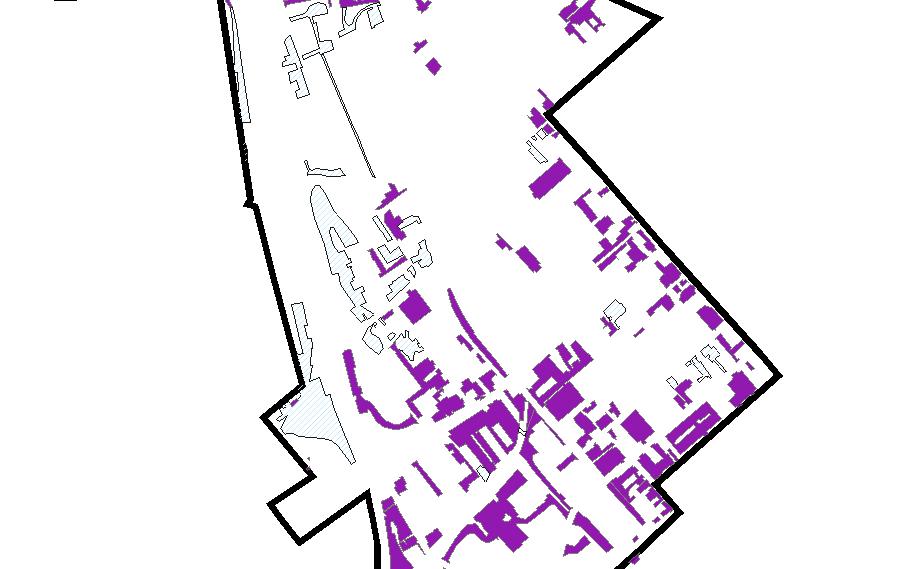
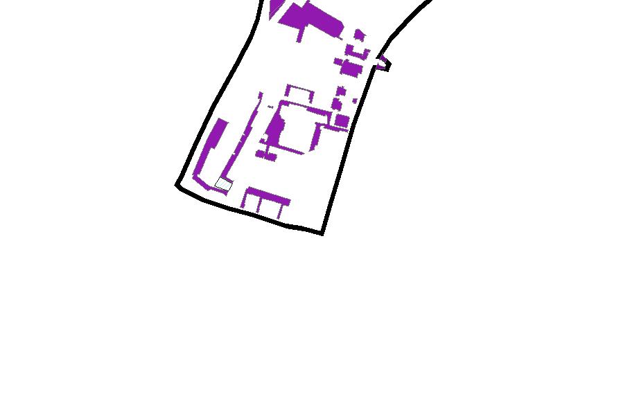
The planning area incorporates approximately 448 acres and is divided into eight distinct subareas, most of which follow generally understood neighborhood boundaries. It contains a variety of residential enclaves, commercial districts and industrial sites. These areas are diverse in their geophysical character, socioeconomic composition, circulation and access (see Map 2, “Subareas,” in Appendix A).
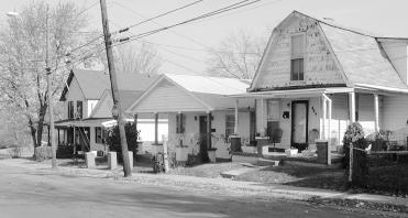
All, or parts, of three historic districts are found in the planning area. Western Suburb constitutes a part of the northern edge. The Historic Western Suburb area typifies development in Lexington in the 19th century. The district was one of Lexington’s first suburbs, being established in the 1830s to house working-class families. Parts of the South Hill Historic District are in the eastern portion of the planning area. The majority of the Woodward Heights Historic District lies in the center of the planning area. Woodward Heights developed during 1890 through 1910, and represents working-class neighborhoods of tradesmen, as well as industrial sites. (See Map 21, “Historic Resources,” in Appendix A.)
Industrial sites are aggregated along the railroad lines and major arterial roads, while the greatest concentration of commercial uses is found along Broadway.

Outside the planning area itself are some major institutions and concentrations of commercial and industrial uses that have influence on the planning area. Industrial and warehouse properties lie to the west of the Southern Railway, while the main campus of the University of Kentucky is along the eastern flank. To the north lies the commercial core of downtown, with historic residential neighborhoods beyond.
Lexington Cemetery lies to the northwest of the planning area. Developed in 1849, this cemetery is representative of garden cemetery

design of the 19th century and was designed to be parklike in setting for passive recreation of nearby residents and visitors. Henry Clay’s monument, a state registered historic landmark, is located there.
The neighborhoods within the planning area include some of the earliest to develop beyond the original core of Lexington. The neighborhoods now known as Irishtown and Davistown rest on the eastern portion of a 400-acre tract of land granted around 1776 to Colonel Robert Patterson, one of the founders of Lexington. Taking advantage of water power supplied by the Town Branch of Elkhorn Creek (a creek running in a northwesterly direction parallel to Manchester Street), several manufacturing establishments were located along this northern land. Among them were Lexington’s first flour mill, operated by John Cox; the Lexington White Lead Manufacturing Company, which manufactured paint and whitewash; and the Lexington Manufacturing Company, which made broadcloth and other woolen goods. These establishments were located in the strip of land between Frankfort Road and Town Branch.
In about 1812, Lexington experienced a sudden boom in development, due, in part, to the war with the British. Wild speculation in land and livestock (Merino Street in Davistown was named for the high-priced Merino breed of sheep) ensued, and many of the large landholdings on the outskirts of the city, including the Patterson estate, were divided and sold.
An Easterner named James Prentiss came into possession of approximately 40 acres of this land in 1812 and proceeded to lay out a town he called “Manchester” on the south side of Old Frankfort Pike. This was then renamed Manchester Street, from Cox Street to a point four blocks west. Prentiss intended to develop the bulk of this land for industrial purposes but was not able to do so, declaring bankruptcy and returning to the east in 1818. For the next 50 or 60 years most of the land southwest of Manchester Street remained vacant, as industrial development stayed on the north side of the street, adjacent to Town Branch. During this period, several of the existing factories in this area were adapted to new uses – the Lexington White Lead Manufacturing Company was converted to a hemp factory in 1833 and finally to a distillery during the Civil War. The Lexington Manufacturing Company likewise became a distillery in 1829.
The land which had been the Patterson Estate was slowly subdivided and sold, as residential development crept outward from Lexington along Versailles Road and Harrodsburg Pike (now South Broadway). The hilltop area just west of the intersection of these two roads gradually developed throughout the middle of the century.
In 1855, only the hilltop area and the industrial area along Manchester Street were developed. By that time, the Lexington and Danville Railroad had established a line which curved through the area along the present route of the Southern Railway’s spur track. This rail line led to the development of a cluster of warehouse and industrial land uses in the southeastern end of the present planning area where the tracks intersected South Broadway. These uses grew during the latter half of the nineteenth century.
The Cincinnati and Southern Railway—now simply the Southern Railway—constructed its main line along the southwestern edge of the planning area in 1872. The railroad further reinforced the industrial and warehouse land uses in the southern end of the area and gave rise to the development of the valley between the railroad and the upland residential areas. By 1896, most of the streets in this lower portion of Davistown were already developed. An additional effect of the construction of the Cincinnati and Southern Railway was the development of an area of “company housing” on much of the vacant land once laid out as the Town of Manchester by James Prentiss. Residents of the area, Irish railroad laborers, gave the neighborhood the name “Irishtown,” by which it is still known today.
The higher land was purchased around 1880 by Lexington developer, J.C. Woodward. This land was gradually developed during the last two decades of the century, as these choice lots were purchased by a number of well-to-do Lexington merchants and industrialists. These people erected the large brick homes which still stand along High Street, Merino Street and Madison Place. The neighborhood is still known as Woodward Heights, in honor of the man who developed it.
After the turn of the century, the pace of development slowed. Residential building tended to be much more modest than before and was scattered throughout the area, as vacant lots were filled in. Industrial establishments slowly expanded their operations and were joined by a number of warehouses, many serving the seasonal tobacco industry. Over a period of years, several residential areas were
chopped apart and isolated by this industrial and warehouse expansion. The residential areas along Chair and Hayman Avenues are prime examples of this isolation.
By the first decades of the twentieth century, South Broadway in the vicinity of Bolivar and Angliana, near the Cincinnati and Southern Railroad, had become the tobacco warehouse district. By the 1920s, Lexington was known as the “Burley Capital of the World,” and most of the tobacco auctions occurred in the South Broadway warehouse area. Some of the tobacco warehouses have been demolished, while several have been converted to educational uses by the University of Kentucky. Still others were converted to non-tobacco related commercial uses.
By the first decades of the twentieth century, South Broadway in the vicinity of Bolivar and Angliana, near the Cincinnati and Southern Railroad, had become the tobacco warehouse district. By the 1920s, Lexington was known as the “Burley Capital of the World,” and most of the tobacco auctions occurred in the South Broadway warehouse area. (Historic photo courtesy of the Audio-Visual Archives, Special Collections, University of Kentucky Libraries.)

Between 1925 and 1930, the west side of South Limestone, south of Bolivar, had clusters of buildings, which were built with commercial uses on the first floor and apartments on the upper floors. The residential neighborhood on the east side of South Limestone was gradually replaced with educational buildings owned by the University of Kentucky, as the institution expanded to the south.
Many of the industrial uses relocated to other portions of the city in the mid-twentieth century. After the second World War, the residential neighborhoods that comprise the bulk of the planning area began to change. The merchants and industrialists who lived in the upper areas began to move out. The large homes they left were sold, converted to apartments managed by absentee landlords, and allowed to fall into various states of disrepair. By the 1950s and 1960s, the smaller frame cottages found throughout the remainder of the area also showed increasing signs of deterioration due to flaws in initial construction, the age of the homes and lack of adequate maintenance.
Development of the Lexington Center and construction of a new viaduct along High Street claimed a number of area homes. The High Street viaduct also caused the demolition of the Lincoln Elementary School, a local landmark located on Valley Avenue in Irishtown.


In early 1980, the Woodward Heights neighborhood was placed on the National Register of Historic Places as an historic district. Reinvestment is evident in the structures found there, as well as in the South Hill Historic District to the east. Housing programs and a variety of other assistance initiatives have also been applied in the area since that time as well. To the east, the University of Kentucky has expanded into several blocks between Limestone and Broadway.


The planning area is, in fact, a collection of smaller “neighborhoods” or “subareas,” each of which has distinct features that reflect historical land uses, topography and geographic location. For example, the Woodward Heights area was shaped by the economics of the downtown. Davistown and Irishtown have long-standing traditions that associate them with the community’s railroad heritage. Pralltown’s unique identity is, in part, derived from its proximity to the University of Kentucky’s main campus (see Map 2, “Subareas,” in Appendix A).
For that reason, the planning area is divided into eight separate subareas. Typically, a subarea reflects the boundary of a specific neighborhood, as it is generally understood by residents and as recorded by the Urban County Government. However, in some cases, the subarea boundary only includes a portion of an established neighborhood, and in other situations combines two of them. The subareas used in this plan are:
Subarea 1: Speigle Heights
Subarea 2: Western Suburb
Subarea 3: Lauderman Alley area
Subarea 4: Pralltown
Subarea 5: Irishtown
Subarea 6: Davistown
Subarea 7: Woodward Heights
Subarea 8: South Hill/UK
Within each of these subareas, differences in their development patterns appear in a variety of ways. As an example, some include interspersed residential and nonresidential uses. Others exhibit a development pattern with a scale and character of streets and buildings more consistent with a “traditional” neighborhood. (A description of these character areas is available as Appendix B, “Planning Area Character Analysis.”)
Many of the characteristics of the individual subareas have been shaped by land uses and development patterns that lie beyond the study area, in adjacent neighborhoods. The key interface areas are located on Map 3, “Interface Areas,” in Appendix A; and development character is shown on Map 4, “Development Character,” in Appendix A. Some noteworthy external influences include:
1. Lexington Cemetery
The 260-acre cemetery lies to the north of the planning area. Historically, the cemetery served as a park for nearby residents, and is a city landmark. It continues to provide a green edge to the northern portion of the planning area.
2. Commercial/Industrial Edge
A concentration of commercial and industrial uses along Manchester Street establishes a boundary to residential neighborhoods in the northwestern portion of the planning area. Historically, these uses may have provided jobs to nearby residents.

3. Lexington Center/Rupp Arena
The Lexington Center complex generates significant traffic and parking impacts. These occur in cycles, peaking during events. The parking lots that frame the western and southwestern edges of the arena form hard edges for the abutting residential neighborhoods.
4. Warehouse District
A series of warehouses, many originally designed for tobacco storage and handling, lie to the west of the Norfolk-Southern Railroad. These also provided employment at one time.
The University creates an irregular edge along the southeastern portion of the planning area. Some blocks are clearly institutional and contrast with adjacent residential and commercial uses. Others are less distinct, resembling warehouses nearby. The University brings impacts, in terms of traffic and housing demand. At the same time, it also offers medical services and employment.
The Broadway corridor is a key influence. It is a “spine” that links the eastern subareas with those to the west and houses a combination of commercial and institutional functions. These provide some services for the neighborhoods and may also offer employment opportunities.
The Harrison Elementary School is located on Bruce Street north of Main Street. Many children in the area attend this school.
Finally, the downtown commercial core lies to the northeast of the planning area. This is a very important relationship. The downtown provides many services used by residents of the area, and it is a major employment center as well. Cultural and entertainment venues also exist there.
Overall elevations of properties within the area have a differential of 65 feet. The highest portions lie to the north and east, around the Woodward Heights neighborhood. This extends as a broad plateau to the southeast, with slopes to the west. Just north of and parallel to High Street, the land drops sharply toward the northeast to the rail yards below and Town Branch Creek. Other portions slope directly to the west, to the lower part of Irishtown.
A ridge line, which runs between Versailles Road and Manchester Street, divides drainage patterns for a portion of the area. This overlooks a valley, flanked on the east by the high grounds of Woodward Heights and Davistown and on the west by the embankment of the main line of the Southern Railway. North-facing slopes along
the Woodward Heights ridge, at Manchester Street, exceed 15%. This area contains a scattering of single family houses.
Pyramid Park is one of the lowest spots in the study area. It is located at the intersection of the Southern Railway line and Manchester Street. The western parking lots of the Lexington Center are also among the lowest areas. To a great extent, De Roode Street is also an especially low area. (See the section on Public Facilities, which follows.)

A few moderately steep slopes exist on some sites that are of interest for potential redevelopment. In some cases, this may require grading or fill. General locations of these sites are indicated on Map 5, “Topography,” in Appendix A.
Flood maps adopted by FEMA do not provide detailed information for the planning area; and a detailed analysis, which is presently underway by the Urban County Government, will be available in the future. Information currently available showing the approximate location of the 100-year floodplain is seen in Map 6, “Drainage Conditions,” in Appendix A. The lower portion of Davistown was described in the 1981 neighborhood plan as having flooding problems, especially along De Roode Street. However, only anecdotal comments in recent public workshops were made about periods of standing water, and these generally refer to unusual peak year events. Only one official complaint has been reported in the area since 1999.
An enclosed culvert, which parallels De Roode Street, drains the lower portion of the study area. This represents the major drainage way for a large portion of the city that lies to the south and east of the planning area.
The Detention Requirement Study performed by Hall-Harmon Engineers for the American Consulting Engineers scoping study assesses the range of possible post parkway detention impacts. Four possible scenarios ranged from minimum right-of-way purchase (Scenario 1), maximum right-of-way purchase with landscaping (Scenario 2), maximum right-of-way purchase with excess developed to existing conditions (Scenario 3), to the maximum right-ofway purchased with excess developed to 100% impervious surface (Scenario 4). These scenarios were assessed in regard to both high and low estimates of existing urbanization. Detention was required to maintain runoff rates at current levels for Scenarios 1, 3 and 4
with low urbanization estimates. All other scenario comparisons (Scenarios 1, 3 and 4 with high urbanization estimates and Scenario 2 with low or high urbanization estimates) did not require detention.
4.1Geologic
The 2001 Comprehensive Plan Update provides a map of Environmentally Sensitive Areas, which include sites with caves, hydrologic problems, geologic hazards, sinkholes and fault lines. At the level of information recorded in that mapping, no environmentally sensitive sites exist within the planning area.
4.2Hazardous
At a finer grain of consideration, sites along the proposed Newtown Pike Extension were reviewed for potential to harbor hazardous materials. Because industrial and auto service businesses have operated in the area for some time, some sites are likely to contain hazardous materials that may influence development opportunities.
The preliminary study for the Newtown Pike Extension identified 20 “sites of concern,” 16 of which are located in the study area (See Appendix D of that report). The 20 sites of concern include abandoned underground storage tanks, abandoned products, contaminated soil and/or contaminated groundwater. That report also recommends that detailed investigations be conducted as a part of the final engineering for the parkway. (The sites of concern also appear as Map 7, “Hazardous Materials Concerns,” in Appendix A of this report.)
Gasoline and oil storage, distribution, and retail facilities were located in the study corridor early in the 20th century. Several gasoline service stations appeared on 1934 Sanborn Fire Insurance maps, but were not inventoried on a subsequent 1957 mapping, indicating possible abandonment prior to 1957. These site-specific contaminants could increase development costs for some parcels.
Numerous warehouses and other buildings constructed prior to 1980 also could have asbestos-containing materials in insulation, floor and roof materials. Lead-based paints could also be present on structures. These issues may contribute to demolition or rehabilitation costs, and therefore individual parcels should be evaluated more closely prior to any redevelopment.
Town Branch Creek is the only blue-line stream in the area. It is confined to man-made channels and storm sewers throughout the corridor and carries urban runoff from areas of downtown Lexington. The exception is a short segment that daylights in the western parking lot of the Civic Center. The creek is a tributary to the North Fork of the Elkhorn Creek, which is a tributary of the Kentucky River. Current plans propose construction of a trail along portions of Town Branch. (See Map 14, “Accessibility Features,” in Appendix A.) No aquatic habitat or wetlands are in the immediate project area of Newtown Pike Extension.

Third Rock Consultants measured the noise from a train passing by the Nathaniel Mission, located in the Davistown area just west of the Norfolk Southern rail line. This line will continue to operate after the Newtown Pike Extension is completed. The measured noise level was 59 dB. This falls below the Housing and Urban Development (HUD) environmental compliance thresholds for review of >65dB or >75dB. If the noise level were to result in an analysis of 65 to 75 dB, further design certification must occur for any new construction. Currently the Kentucky Transportation Cabinet indicates that 27 trains per day cross the South Broadway overpass. Additional monitoring and analysis of train traffic is required to determine compliance with HUD thresholds.
Profiles of residents within the planning area are described in a supplemental paper, Demographic Profile of Newtown Project Corridor, Appendix D That paper summarizes data provided by the Census Bureau, as well as information gained from a survey conducted door-to-door and distributed in newsletters, public meetings and in neighborhood association meetings. Currently 2000 Census data is available at the census tract level. Block data has just been released and will be included when an analysis is complete. 1990 block data is used in place of pending 2000 Census data, except as noted.
The door-to-door survey was conducted on November 3, 2001; and approximately 75 residents in the Davistown, Irishtown, Pralltown, and Woodward Heights neighborhoods were interviewed. Fifteen more surveys were received through the newsletter and meeting dis-

tribution process. A brief summary of some socioeconomic data is presented in this section. Readers should review the full supplemental paper, however, because the detailed discussion found there provides important interpretive conditions.
Data is derived for four census tracts that comprise the planning area:
Tract 1: Contains Western Suburb and Woodward Heights
Tract 9: Contains Davistown and Pralltown
Tract 10: Contains Irishtown and Speigle Heights
Tract 11: Contains the Lauderman Alley area
The boundaries of the tracts are indicated on Map 8, “Census Tracts,” in Appendix A.
In general, populations have been declining in the area. In 1978, the estimated population for Irishtown, Davistown and Woodward Heights was 2,271 people. The 1981 plan estimated 1,723 people in that area, a decline of 24%. These trends have continued in the 1990 and 2000 data, as is discussed in section 6.0, Market Conditions, that follows. (See also Table 2 in Appendix D.)

Other key statistics are available for the four census tracts, of which portions encompass the planning area:
•Average household sizes range from 1.61 to 2.73. (The average household size for Fayette County is 2.29 persons.) Of these, the smaller households are in the tract containing Woodward
Heights and Western Suburb, while the largest household size is in the tract containing Irishtown and Speigle Heights.
•The percentage of owner-occupied housing ranges from 12.1% in Western Suburb to 55.2% in the Lauderman Alley area. Woodward Heights has 39.6% resident owners, while Irishtown has 28.1%.
The 2000 Census data indicate that one-race minorities make up 18% of the population for Lexington-Fayette County. Minority populations in the census tracts that contain the planning area are higher. African-Americans comprise the largest percentage of the minority population. These range from 27% One-Race Minority in Tract 9 to 65% One-Race Minority in Tract 11. (See related chart on p. 6 of Appendix D.)
The data provided in the Demographic Profile indicate that each neighborhood has some distinct features. Davistown, Pralltown and Irishtown are areas with long-term associations with their neighborhoods. Average length residencies of 25 to 37 years are reported in these neighborhoods. In the door-to-door survey, more than half of the respondents also reported that they have other family members living in their neighborhood, indicating an additional level of association with the area.
In contrast to Davistown and Irishtown, the Woodward Heights and Western Suburb neighborhoods have higher incomes and shorter terms of residency. In Woodward Heights the average length of residency is four years, which probably reflects the influx of new owners into the area as a part of revitalization efforts.
Home ownership rates have increased in the past 20 years for portions of the planning area, including Woodward Heights and Western Suburb. (See Table 3 in Appendix D.) The study also indicates that, for many of the neighborhoods, the percentage of those who rent their homes remains greater than the city-wide average, particularly in the lower income portions. The percentage of renters includes 87.8% in Western Suburb, 60.3% in Woodward Heights and 81.4% in Davistown. Lower renter percentages are found in the Speigle Heights area (46.4%) and in the Lauderman Alley area (32.5%). (By comparison, the county-wide average of renter-occupied units is 47%.)
At the same time, rental housing is an important component of the community’s overall housing supply, and many people choose this type because of lower entry cost, low maintenance responsibilities, or because it facilitates mobility.

Of those who rent, people living in the Irishtown and Davistown areas spend the greatest percent of their household income on rent. The average percentage in Irishtown, for example, is 34.5%; and in Davistown it is 35.1%. (See Table 5 in Appendix D.)
Many of the areas are substantially below median in annual income, while some neighborhoods are close to the county median, which was $28,056 in the 1990 census. Median household incomes in the planning area range from $7,333 in Davistown to $26,307 in Woodward Heights.
Other income statistics:
•In Census Tract 9 (Davistown), more than 51% of the population have an income of less than $22,445, which meets the definition of “low income” (80% of the county median income of $28,056).
•The highest income neighborhood in the planning area is Woodward Heights, which has a reported median household income of $26,307. (See Appendix D for a complete table.)

The median age of residents in some part correlates with household income, length of residency and household size. Median age is lowest in Irishtown (20 to 22 years) and Davistown (25 to 29 years). Median age is highest in Pralltown (40 to 44 years) and the Lauderman Alley area (also 40 to 44 years). Western Suburb’s median age is also relatively high, with a median age of 35 to 39 years. (See Table 5 in Appendix D for a complete table.)
In terms of market potential for commercial development, an analysis by Lane Consultants identifies an immediate trade area, focused on the Broadway corridor, of approximately 10,856 people, combined in 4,855 households. This “Polygon Trade Area” is defined using 2001 demographic data as a means of determining potential redevelopment opportunities. The 2001 estimates are updates based
on the most recent U.S. Census data available (2000 and 1990). The polygon trade area encompasses the planning area, as well as some other blocks nearby and is approximately 2,500 acres in size. It is defined approximately by a half-mile radius from the intersection of Broadway and Newtown Pike Extension, but extends farther to the north beyond Main Street.
In addition to the polygon trade area study, a second, larger trade area, which covers a 1.5-mile radius from the intersection of Broadway and Newtown Pike Extension, was prepared using the same database and contains approximately 4,500 acres. This includes residential and commercial real properties within a circular trade area, which is denoted on Map 2, p. 16 in Appendix E. This larger trade area is a factor in determining the market potential for larger retail establishments that would serve an expanded region. It contains a population of 37,431 people in 14,460 households. Under existing conditions, projections into the year 2006 forecast that the population within the trade area will decline by about 300 people, while the larger radius area may increase by approximately 50 people.
Essentially, these projections anticipate a stable population. This, of course, does not include any changes that may occur through redevelopment that might attract more residents into this area. (The complete market study constitutes Appendix E of the Plan.)
Between 1980 and 2001, the population within the polygon trade area declined from 12,747 to 10,856, a drop of 6.5%. Within the 1.5-mile radius, population remained static, being 38,824 in 1980 and estimated to be 37,431 in 2001. During this same time, the overall population in Fayette County increased 16.8%.


Housing in the polygon trade area is valued at about 50% of the median property value for Fayette County ($37,531 versus $75,861).
(See Table 4, p. 13 in Appendix E.)
Although long-term demographic trends for the trade area are static, when the Newtown Pike Extension is constructed, it is likely that the resulting enhancements to existing neighborhoods will reverse a 20-year gradual decline in households and population.
Stable neighborhoods and increased demand for housing will stabilize property values in the trade area. As property values increase over the next decade, it is likely that per capita incomes, disposable incomes and retail sales within the trade area will also increase. Per capita income in the trade area is approximately 65% of that of Fayette County. 2002 retail sales potential in the trade area is estimated to be $375 million (see page 52 in appendix E). This volume of retail sales potential is more than adequate to support up to 300,000 s.f. of additional retail shopping that could be developed in the trade area. Most of the retail sales are presently being displaced to other retail centers located outside the trade area.
Retail sales in Fayette County increased from $2.46 billion in 1992 to $3.98 billion (est.) in 2002, a 62% increase. Based on historic trends, it is reasonable to forecast that retail sales in the Newtown Pike trade area would increase to more than $600 million over the next ten years. This increase does not take into consideration anticipated potential increases in population due to redevelopment of existing buildings and vacant properties, higher density residential land uses, increases in student enrollment at the University of Kentucky or increases in daytime population.


All of the foregoing market trends in the Newtown Pike trade area would support the successful redevelopment of under-performing commercial properties into business locations for retail trade and service businesses. Stabilizing population density and improving the demographic characteristics of the trade area will help support a retailer’s interest in serving this area.
Potential Uses:
Specific land use opportunities are described in the market study.
Potential uses include:
General Retail - Grocery, small shopping centers
Service Business - Cleaners, shoe repair, etc.
Highway Business - Automotive service related or destination business categories, convenience stores, quick service restaurants, automotive repair
Professional Office - Private and governmental; also start-up technology and entrepreneurial businesses
Office/Warehouse/Flex space - Auction and art galleries, flea markets, sale of household goods

Warehouse/Wholesale - Warehouse
Residential - Single family, two-family and multifamily


Affordable Housing
Affordable housing for lower income residents in the planning area is a special concern. An economic overview in 2001, prepared by Ed Starkie and Leland Consulting for the Infill Study, provides these insights:
Affordability is usually classed into categories related to median household income. In Lexington-Fayette County, the median household income in 2001 was approximately $41,500. Within a one-mile radius of downtown, the median income was approximately $24,000, or around 60% of the city median.
Two lower income groups are typically considered when planning for affordability: first, households at or below 30% of median income represent the lower segment. Within the county, 14% of households are at or below the 30% median income level. In LexingtonFayette County, a home must be priced at $45,000 or less for this group to maintain ownership. In 2000 only three percent of the units on the market were priced at or under that amount.
The second group contains households between 30 and 60% of median income. Approximately 13% of the population in the county falls within this range. A house must be priced below $90,000 to be affordable for this group. Last year, approximately 25 of the units offered for sale were within this price category.
For infill in neighborhoods surrounding the downtown core, this suggests a necessity to plan for housing types that can allow ownership with pricing at or below $90,000 per unit and rental units affordable for those at or below 30% of median income.
Based on a 2001 report by Leland Consulting, total household growth in Lexington-Fayette Urban County is expected to be approximately 4,500 households from 2000 to 2005. Typically, sales of units would be to households earning over $35,000 per year and with built-up equity. The household growth for this segment of the population indicated in their projections is approximately 6,900 over the same five years. These projections indicate that there is likely to be a moveup market, a favorable condition for infill development, because the market segment qualified for ownership is growing faster than the total population.
At the same time, over 27% of current households are at or below year 2000 estimated median income. Given the stronger position of the market rate buyer, the goal for successful infill should be to provide a mix and range of housing opportunities for all income levels to reinforce older neighborhoods and create balance in the housing stock.
Currently the University of Kentucky does not require freshmen to live on campus, but the majority of the first-year students choose to live there. Overall, the University houses 24% of the undergraduates and approximately 14% of the graduate students. Undergraduate fall enrollment is above capacity. A proposal to acquire a housing complex near the University may be approved prior to the fall semester; however, there are no major current plans for expansion of the on-campus housing program. It is anticipated that an expansion will be needed in the near future and is being studied as a part of the “College Town” plan currently under preparation.
Occupancy levels of office/warehouse/flex space in Fayette County is high, demonstrating that demand for lower cost business locations is strong. In addition, potential may exist to develop an entertainment district – providing a variety of night life in the central business district, concert facilities, restaurants, dance clubs and meeting facilities. Some of the older warehouses may be particularly suited for this use. Mixed use projects, which include commercial and residential uses, also have potential in the area.
Several industrial properties appear to be underutilized. Improved access may be the stimulus necessary to cause redevelopment for industrial type uses. Office/warehouse flex space also can enhance the appearance and final market value of properties that are currently underutilized or vacant.
The market study also identifies nine key locations where a range of viable development options are described. (These are located on Map 3, p. 21 in Appendix E.) These generally lie along the Newtown Pike Extension. Of these, many of the sites positioned at major intersections are opportunities for commercial uses. Residential infill opportunities lie along edges of established neighborhoods.
As the entire study area lies within the bounds of Lexington’s enterprise zone program, a number of incentives may be available to qualified businesses. These incentives include tax exemptions and low interest loan programs and would apply to new or expanding businesses. The program is administered by the Mayor’s Office of Economic Development and is currently authorized through 2004.
Factors which were considered in ascertaining land use recommendations include:
Location – the relationship to traffic generators, adjacent uses and visibility
Physical – topography, parcel sizes, site access
Demographic – population, income, age
Economic – value of current improvements, zoning and construction costs
Competitive – direct competition from existing similar land uses, supply and demand for similar real property
Existing land uses are found in 16 categories within the planning area. These range from Low Density Residential, Very High Density Residential, Retail Trade, and Light Industrial to Warehouse and Wholesale. In general, retail land uses are grouped along Nicholasville Road/Limestone Street, Broadway, Manchester and Versailles. Industrial uses lie along the older railroad lines, especially in Davistown and the Lauderman Alley areas. Some Very High Density Residential uses are clustered near the western edge of the University, while High Density Residential uses can be found throughout the study area in Irishtown, Pralltown, Davistown and Woodward Heights. Low Density Residential is only found in Speigle Heights, with Medium Density Residential found in the Western Suburb; Woodward Heights; South Hill/UK; Davistown and the Lauderman Alley area. (“Existing Land Uses” are shown on Map 9 in Appendix A.)
The approximate distribution of existing land uses within the study area is as follows:
In addition, a more detailed summary of land uses found in each of the subareas is described in the Table in Appendix B, “Planning Area Character Analysis.”
The existing land use map shows vacant parcels which equal approximately 21 acres, almost 5% of the study area. By comparing these sites to the existing zoning map, approximately 5% are in residential zones, 10% are in commercial zones and 85% are in industrial zones. In comparison, the amount of undeveloped land inside New Circle Road was approximately 4% in 2001.
The planned future land use for the area is defined in the LFUCG 2001 Comprehensive Plan Update, and a detail of the related map appears as Map 10 in Appendix A of this report.
Seventeen land use categories occur in this area. These range from Low Density Residential to Warehouse & Wholesale, Retail Trade and Office/Warehouse Mixture to Green Space/Open Space. The general organizational concept for these uses is to locate commercial categories along major corridors, such as Broadway and Manchester. Industrial uses are sited along major arterial streets as well as rail lines. Higher density residential uses generally serve as transitions from these categories to lower density residential categories. Specific zoning categories for each of the planning subareas are summarized in the Table in Appendix B, “Planning Area Character Analysis.”
The approximate distribution of currently approved land uses within the study area are as follows:
For some of the properties to the west of Broadway, between Maxwell and Bolivar, the current land use is WW – Warehouse/Wholesale, whereas the 2001 Comprehensive Plan Update calls for it to be “RO – Retail/Office Mixture,” which includes a required residential component. (This is essentially a zoning category that does not presently exist. The Residential Infill and Redevelopment policies recommend creation of a Mixed Use Zone that would fit this description.)
Another method of mixing uses is described in the 2001 Comprehensive Plan Update for a portion of the Lauderman Alley area, in which two defined types, “RT/PS – Mixture of Retail Trade and
Service,” are blended together. Presently, these zoning categories have not been established for these parcels.
Twelve different zoning categories exist within the planning area. These include single family categories, a two-family zone, multifamily, business and industrial zones. In general, commercial zoning categories are grouped along the major radial streets in the planning area, specifically Versailles Road, Broadway and Nicholasville Road/Limestone Street. To some extent, commercial uses are also located along portions of Manchester Street, which is a subordinate radial road. Industrial uses are also located along these roads. However, they also lie along the older railroad lines, especially the Southern Railway. Some multifamily uses are clustered near the western edge of the university. The only other major multifamily use is in Irishtown. (See Map 11, “Existing Zoning,” in Appendix A.)
Note that since the current zoning map was adopted, the Residential Infill and Redevelopment Study has recommended creation of a new set of Mixed Use zones, with the objective of encouraging development of residential units in combination with commercial uses. This zoning category is yet to be formally created, but the concept is relevant in portions of the planning area.
An approximate distribution of existing zoning within the study area is as follows:
A comparison of the planned land use from the 2001 Comprehensive Plan Update with existing zoning indicates some parcels where conflicts exist. These are shown on Map 12, “Existing Zoning Conflicts with Future Land Use,” in Appendix A.
One area with conflict is on the southwest corner of the future Newtown Pike Extension and Main Street. The existing zoning is Light Industrial (I-1), and the planned land use is High Density Residential (HD). The area along Lauderman Alley has the same current zoning, while the planned land use calls for Very High Density Residential (VHD).
Davistown represents an additional industrial zoned area in conflict with planned residential land use. Currently the majority of Davistown is zoned Light Industrial, while the planned land use calls for a large portion of the area to contain Medium Density Residential uses.
Another area of conflict is the southwest corner of Manchester and Pine. It is currently zoned B-4 (Wholesale and Warehouse); the planned land use is Retail Trade.
In some cases, the existing land use does not match the legally adopted zoning category. Map 9 in Appendix A indicates the actual land use to which properties are put. In many cases, these coincide with the designated zoning; but in some cases, differences occur. In most situations, these are considered nonconforming uses.
A summary of zoning designations and existing land uses is presented in the descriptions of the character of the individual subareas. (See Appendix B, “Planning Area Character Analysis.”)
The area with the greatest conflict is along De Roode Street where the existing land use is a mixture of Warehouse and Wholesale, High Density Residential and Medium Density Residential, while the existing zoning is Light Industrial.
In the planning area, residential lot sizes vary widely. Many of the smaller lots in Irishtown are slightly larger than 2,000 square feet, although the majority of the residential lots in this neighborhood range from 3,000 to 6,500 square feet. Typical lot sizes in Woodward Heights are 6,500 to 7,000 square feet. Lot sizes vary widely in Davistown; some are as small as 1,000 square feet, although typical ones are 2,500 square feet. Lots in the northern portion of Davistown can be as large as 6,000 square feet.
Ownership patterns vary across the planning area. The University of Kentucky is the only single major land owner in the planning area. Some churches have acquired several properties, with expectations of using them for their own objectives. These acquisitions may influence the details of some redevelopment strategies.
With respect to residential properties, most lots are relatively small. Redevelopment for multifamily will typically require acquisition of several lots. In some cases, property titles are clouded, and this may inhibit some project development. Commercial property ownership patterns tend to be relatively straightforward.
As a part of the planning effort, consultant team members conducted a windshield survey to rate the condition of the exteriors of existing properties. Overall building condition could be affected by building interior conditions. Poor conditions in structural systems, as well as wiring and plumbing, could exist, for example. With respect to the exterior survey, many properties have newer metal siding which could conceal decay. A total of 856 parcels were surveyed, of which 808 had structures. The survey considered a range of key building components, including the condition of roofs, walls, foundations, windows and doors. Each of these building systems was evaluated in one of three categories: (1) Good, (2) Minor Deficiency, and (3) Major Deficiency. Exterior building conditions are discussed in more detail in Appendix C.
The total number of deficiencies were rated for each property and then an overall rating of exterior condition was assigned. Four categories were used:
“Good” – The building is sound, and either needs no repairs or one minor repair. The repairs could be corrected by a regular maintenance schedule.
“Fair” – The building is sound, where either one major repair or several minor repairs need to be made. The repairs could be corrected by regular maintenance and minor repairs.
“Poor” – The building needs some more significant rehabilitation efforts in order to provide a safe shelter to its occupants. The building may need several major repairs, a large number of minor repairs or a combination of a single major repair and several minor repairs. From an economic standpoint, this building can be saved.
“Dilapidated” – This building requires either a number of major repairs or a combination of major repairs and minor repairs. It is beyond rehabilitation; and from an economic standpoint, this building cannot be saved.
Total number of structures surveyed: 808
An important limitation of this type of survey is the lack of interior inspection data which, based upon the age of the area alone, would likely indicate a higher proportion of deficient structures.
The LFUCG Roadway Functional Classification is used throughout the city to indicate the level of service they are designated to carry. Four categories are used:
1.Major arterial - (such as Limestone and Broadway)
2.Minor arterial - (such as Manchester and Short Street)
3.Collector - (such as Cox Street and Angliana Avenue)
4.Local Street - (such as Pine Street and Robertson Street)

Map 13 in Appendix A shows the Roadway Functional Classifications within the planning area.
An analysis of vehicular circulation is reported extensively in the Newtown Pike Extension Project Report June 2000. This includes documentation of the existing traffic volumes and those projected to occur with the completion of the Newtown Pike Extension. The report describes the intent of the Newtown Pike project to improve the flow of through traffic and to draw unnecessary traffic out of the

downtown, as well as minimize the impact on the University of Kentucky central campus area via more efficient vehicular routes. It also would reduce automobile traffic congestion and improve the pedestrian environment.
9.1Traffic Congestion
That report describes significant traffic congestion occurring along Main Street, from Newtown Pike to Broadway and on to Limestone. Broadway, from Maxwell Street to Main Street, has also become very congested. The Limestone Street intersections with High Street and Main Street are also congested. All of these are issues that the parkway construction is designed to address. In fact, with the construction of Newtown Pike Extension, some street traffic volumes will decline. About 60% of the traffic projected to use Newtown Pike is destined for the University of Kentucky and locations in south Lexington.
Primary automobile access routes for residents in the planning area are along Manchester, Versailles and Broadway. High and Maxwell Streets also serve as access points into downtown.
Within the individual neighborhoods, access patterns vary. Speigle Heights, for example, is accessed primarily through a single point, Robertson Street. By contrast, Pralltown is accessible from a variety of streets along its eastern and southern edges, but is more limited along the western and northern sides. Others, such as South Hill, are accessible from a wide range of points. General accessibility patterns are illustrated on Map 14, “Accessibility Features,” and more specific conditions at the neighborhood level are included in Appendix B, “Planning Area Character Analysis.”
The Newtown Pike Extension Report identifies key intersections for special planning consideration. Key intersections are shown on Map 14, “Accessibility Features;” in Appendix A. Among those studied, the following have special interest to the Extension Corridor Plan:
Gateways
Newtown Pike and Main Street


This is a gateway to downtown because of the high traffic volumes from both Newtown Pike and Leestown Road.
Map #14, “Accessibility Features,” identifies a set of points at which automobile traffic conflicts with pedestrian crossing and bicyclists. Many of these conflicts will be reduced with the advent of the Newtown Pike Extension, which will divert through traffic from these areas of conflict. The map also indicates congestion on Broadway, which also will be relieved with the opening of the parkway.
Broadway Intersection
This intersection of the parkway with Broadway is a key gateway. This will serve as a major entry point for Newtown Pike.
Main Entrance to the University
This is a key gateway into the University of Kentucky and a major access point for the parkway from Limestone Street.
Versailles Road
Versailles Road is also a key street and, as an entry into the area, one of the most unattractive. Its intersection with the parkway is a key gateway.
Key Intersections
Manchester Street Access
Manchester Street is the lowest point on the corridor, outside of Town Branch. An at-grade intersection is planned. The intersection should be designed to accommodate Town Branch Trail development concepts.
Patterson Street
An intersection of the parkway with Patterson Street is planned. This may become a major intersection, with streetscape design opportunities. This is the principal entry to the University of Kentucky from Newtown Pike.
Other Existing Intersections
High and Pine Streets Intersection
The parkway design recommends elimination of the intersection of Pine Street with High Street to accommodate traffic volumes.
Pine Street and Newtown Pike
No full intersection is planned; only a right turn into Pine Street and a right turn out of Pine Street. There will be no median opening at this location.
Merino Street
Access via Merino Street between Southend Park and the northern portions of Davistown is desirable. A right-in and a right-out at Merino would provide the desired access. Alternative plans may eliminate a connection, or it may be limited to permit intra-neighborhood circulation but discourage through traffic.
On-street parking spaces exist on most streets within the planning area. Off-street parking is located throughout the area on individual parcels. For many residential properties, parking is located in unpaved driveways. Paved driveways are found in portions of Pralltown, Woodward Heights, Irishtown and Speigle Heights.
Paved parking lots are generally located with commercial and institutional facilities throughout the area. Most are distributed along Broadway and Manchester Streets. Many unpaved lots exist, which are typically associated with industrial sites. Some are located along De Roode Street, while others are along Manchester and North Newtown Pike.
The University of Kentucky is currently engaged in developing a new master plan, which could have significant impact on the eastern portions of the planning area for this Newtown Pike Extension Corridor Plan. The University’s current plan calls for a parking structure on the north side of Euclid at Lexington Avenue, approximately two blocks east of the planning area boundary. (See related Map 15, “Off-Street Parking Areas,” Appendix A.)
Neighborhood cut-through traffic in Pralltown from the University of Kentucky lot on Scott Street is a major problem for neighborhood residents. Maintaining on-street parking for residential use along Scott Street will also be a design concern. Likewise, the need for more long-term on-street parking in the historic South Hill Neighborhood closest to campus is also a concern for residents there.

The Lexington Transit Authority (LexTran) provides public transportation in Lexington. The current LexTran system uses a transit center concept with a downtown transit center. The radial nature of the city’s street system makes the Central Business District a convenient central transfer point. Transit routes radiate along arterial streets to outlying suburban areas. LexTran operates three levels of service: peak period, mid-day and night service.
The public transit system provides the mobility for low and moderate-income people to work and find housing throughout the community. In the Year 2025 Transportation Plan, LexTran proposes to continue the current level of service, with limited improvements.
Additional grant funding may increase the number of improvements that would be implemented in the coming years.
Key bus routes operate along Versailles Road, South Broadway and Nicholasville Road. These all link outlying neighborhoods with the downtown transit center. LexTran operates seven days a week, with increased frequency of service during weekday peak hours.
The route on South Broadway operates between Eastland Shopping Center and Harrodsburg Road. This route provides access to downtown for residents of Davistown and South Hill.
Routes that may be affected by the extension are Newtown Pike and Georgetown Road. (See related Map 16, “LexTran Routes,” Appendix A.)
The transit route on Versailles, which operates between New Circle Road and North Limestone, provides access to downtown for the Speigle Heights, Irishtown and Woodward Heights neighborhoods. This route also serves portions of Davistown.
Three routes operate on Nicholasville Road, with one operating between Hamburg Pavillion and Winchester Road and the Transit Center. A second is designated Russell Cave Road – Nicholasville Road, and the third is Leestown Road – Richmond Road. Combined, these routes provide access for Pralltown and portions of South Hill neighborhoods, as well as the University of Kentucky.
Finally, the Georgetown Road – Woodhill Drive route provides service in northern portions of the study area, specifically for Western Suburb.
The Town Branch Trail has been proposed by the Friends of the Parks of Fayette County, Inc. to be developed through the area. This is envisioned as being a greenway, which will be a walking, running and biking trail that leads from downtown through the western suburbs, and into the countryside, following the waterway on whose banks the city was founded. However, in the downtown area, the
trail would use the sidewalk system and descend to a water-edge trail near the intersection of Manchester and High Streets.
Town Branch runs in an underground culvert through the heart of the downtown, and surfaces along Manchester Street near the proposed Newtown Pike Extension Project. The potential crossing point of Newtown Pike for the trail has been identified as a grade separation in the preliminary road design. (See Map 14, “Accessibility Features,” in Appendix A.)
The University of Kentucky anticipates coordinating bicycle connections with bike routes in the vicinity of the University. Virginia Avenue was cited as a potential route.
The pedestrian system in the planning area consists primarily of sidewalks along established streets. In some portions, such as lower Davistown, pedestrians use the streets because no sidewalks exist. Pedestrian circulation is inhibited by the natural and structural barriers that frame the area, particularly the Southern Railroad embankment, the elevated portion of Versailles Road, and the inactive rail extension that is the proposed location of the Newtown Pike Extension.

Pedestrian crossing conflicts were noted as a concern for students crossing Limestone Street between Scott and Rose Streets. The City should cooperate with the University of Kentucky to consider possible traffic calming improvements to improve the situation.
Key pedestrian routes into downtown are along Main, Merino, Broadway and High Streets. Internally, Merino and De Roode serve as major access routes to Southend Park and the Nathaniel Mission. Manchester Street serves as a key access route to the Manchester Center. A segment of abandoned tracks links Pralltown with Broadway. Jefferson Street links much of the study area to the Harrison School. (See Map 17, “Pedestrian Routes,” in Appendix A.)
By 1877, most of the railroad lines that linked Lexington to Louisville, Cincinnati, and the Ohio River were in place. The Cincinnati and Southern lines defined the southern edge of Lexington. The Kentucky Central Railroad had a terminal on the west side of Payne Street, opposite its intersection with Short Street, at the northern edge of the current planning area.
Town
runs in an underground culvert through the heart of the downtown, and surfaces along Manchester Street near the proposed Newtown Pike Extension Project.

The CSX line continues to a rail yard, which lies north of Manchester Street and west of Cox Street.
The Louisville and Lexington Railroad came into Lexington north of Town Branch and south of the Roman Catholic cemetery. An engine house and freight depot for the Louisville and Lexington Railroad were located in the vicinity of the present day Rupp Arena and Civic Center.
There were two lines of the Cincinnati and Southern Railroad: one line came in from the north parallel to Cox Street, crossing Manchester Street and Versailles Road, before continuing to South Broadway; and a main line that continued south on the west side of Danville Pike (present day Nicholasville Road).
Today, two rail lines cut through the planning area. A Southern rail line runs along the western edge of the planning area. This line enters the study area along its southwestern edge, at Virginia Avenue. It proceeds northeasterly to Colfax Street, where it swings more northerly. It crosses above Broadway and continues northward, where it forms the western edge of the planning area to Versailles Road. It passes below Versailles Road and, from there, it provides the boundary between the Speigle Heights and Irishtown neighborhoods.
A second rail line, the CSX, enters the planning area from the north. This line crosses Newtown Pike at West 3rd Street. This is an atgrade crossing. Reportedly, trains sometimes perform switching operations in this area, which occasionally delay automobile traffic on Newtown Pike. According to the railroad coordinator, there are 12 trains per day crossing Newtown Pike between 2nd and 3rd Streets. The line continues to a rail yard, which lies north of Manchester Street and west of Cox Street.
The Newtown Pike Extension study reports that the CSX Siding, in the rail yard, was created when the CSX yard adjustment was implemented, concurrent with the Civic Center parking lot expansion under the Jefferson Street viaduct. The report notes that CSX Railroad is reluctant to give up any additional track and sidings.
Kentucky-American Water Company (KAWC) provides water service to the study area. They have two storage tanks, along with two pump stations located within the study area on Cox Street. One is an elevated tank and the other is a ground storage tank. They are filled

and drained by a water main on Cox Street and transmitted to a subsystem of distribution mains. A majority of the mains and water lines in the study area are 25 years or older. Ongoing projects include improvements to the downtown water distribution system, upgrading Cox Street tank refill capabilities and routine maintenance to fire hydrants, water meters and valves. KAWC indicates that they could accommodate water services to new infill in the study area. In any case where new road alignment would be incorporated into a major infill project, the water company would need to make modifications or improvements to the facilities in the area in order to accommodate distribution of services to any structures that were placed in areas not previously served.
Similarly, the Fire Department reports that water supply was adequate for fire protection, but that infrastructure improvements may be needed if significant infill and redevelopment occurs. Infrastructure improvements by the KAWC and the Fire Department would be coordinated. In most cases, the water company improvements would need to be implemented to allow the increased water supply needed for the Fire Department.

A recent report, The Final Submittal of the Comprehensive Sanitary Sewer Project: Remaining Unsewered Area, prepared by GRW Engineers, Inc., documents the unsewered areas in Lexington. Within the Corridor Plan study area, seven developed properties remain to be sewered. These properties are located within Davistown, Pralltown and the Lauderman Alley area. In addition, there are 26 developable properties that have no sewers provided. The majority of these properties are located in Davistown; others are located in the Lauderman Alley area. (See related Map 18, “Sanitary Sewer Lines,” Appendix A.)
According to the Director of Sanitary Sewers, the study area, like many of the older parts of the city, has sewer collection lines that remain unidentified. The system lines are almost certainly in fair to very poor condition due to their age and the predominant use of cracked and unsealed clay tiles. A standard closed-circuit television inspection of all lines in the area should be conducted to evaluate their condition and to plan for the ultimate repair of the system. The sanitary sewer trunk lines along De Roode Street are in very poor condition and need to be replaced with larger capacity pipe.
A windshield survey of the conditions of curbs, gutters and sidewalks was conducted by Planning Division staff in January 2002. Areas with deteriorated materials were noted, as well as places where some infrastructure elements were missing altogether. The locations of these conditions are shown on Map 19, “Curb and Gutter Condition,” in Appendix A.

Curb and gutter conditions were noted as follows:
Community facilities in the planning area include educational and medical services, community centers and parks (see related Map 20, “Community Facilities,” Appendix A).

The main campus of the University of Kentucky is located to the eastern edge of the planning area. Bolivar Street serves as an informal connection to the campus from the Broadway corridor and the neighborhoods west of it. The University also owns property in the planning area, between Broadway and Upper Streets.
The University reports that its long-term acquisition plans for future expansion within the planning area call for purchasing all the land along South Broadway from Bolivar south to approximately Scott Street. Also included in the acquisition plan is a small section in the southeast region of Pralltown from Maxwelton Court south to Virginia Avenue.

The University of Kentucky Medical Center and Good Samaritan Hospital, two hospitals in the county, lie to the east of the planning area. Emergency and long-term medical care are available at these
facilities. In addition, the Nathaniel Mission offers a number of free health and dental care clinics for local residents. The Mission is currently pursuing land acquisition and site planning to expand facilities for the free clinics.
Current plans suggest that the University of Kentucky Medical Complex may expand west of Limestone, from approximately State Street on the south to Virginia Avenue on the north. This northern edge of expansion would abut the southern boundary of the Pralltown neighborhood.
While these medical services provide high quality care to the residents of the planning area, the growth and expansion of these facilities could also stimulate development of related professional businesses, particularly in the area above Pralltown and east of Broadway.
Two neighborhood elementary schools, G.W. Carver and Lincoln School, were closed more than 20 years ago; and the majority of the area students have since attended Harrison, Picadome and Garden Springs Elementary Schools. Harrison is located on Bruce Street north of Main Street; the other two elementary schools are off of Harrodsburg Road, well outside the study area. Some residents have reported their preference to send their children to alternative schools. If they do, busing services are not provided; therefore, parents must walk their children to alternative schools.
The Fayette County School system shows no projection for growing enrollment in the schools in and around downtown Lexington. These schools are operating under their maximum enrollment. Current redistricting may affect where children in the study area attend school.
Three community centers operate in the area. The Manchester Center is located in the Irishtown neighborhood along Manchester Street. The Manchester Center offers a number of different programs to the community, such as a preschool and youth services, including tutoring and reading programs. The Nathaniel United Methodist Mission is located on De Roode Street in Davistown. The Mission provides health care clinics, food pantries, counseling and other support services to area residents, primarily from Davistown and Irishtown. The Carver Neighborhood Center operates in the old

Carver Elementary School. The Center is currently operating without a budget. It serves 25 to 50 children a day in free afterschool programs and also provides a clothing bank.
In addition, the Salvation Army headquarters is located at the intersection of West Main Street and Newtown Pike. It recently constructed an addition, which is accessed from Cox Street. The Salvation Army has an on-site youth program - the Boys and Girls Club of the Bluegrass, which provides afterschool programs for children in the area. (See related Map 20, “Community Facilities,” Appendix A.)
Currently there is no anticipated need for additional park space in the area surrounding downtown Lexington. Parks and Recreation is in the process of meeting the Americans with Disabilities Act (ADA) standards, which includes improved sidewalks, site furniture, site lighting, drinking fountains and signage at most parks. Each park has a specific “wish list” of funding needs developed by the Parks Division in its plans. These needs are approved per fiscal year, as funding is available. In addition to the ADA standard improvements, many of the parks have need for basketball court resurfacing and repair or additions to site features. A neighborhood park and a collection of pocket parks are located in the area.
Pyramid Park is located at the intersection of Manchester and De Roode Streets and is accessible to most residents of Irishtown. The rail line forms the western edge of the park, which covers over 1.5 acres.
Speigle Heights Park is located in the westernmost portion of the planning area, within the Speigle Heights neighborhood. It covers approximately one acre, and there are plans to add a small community center to the site in the future.

Speigle Heights Tot Lot is located a block south of Speigle Heights Park. It covers less than a quarter acre and is currently undeveloped.
Southend Park lies between De Roode Street and the proposed Newtown Pike Extension. It serves a large extent of the planning area, including much of Davistown. It covers approximately six acres.
Carver Center Park is the open space associated with the Carver Neighborhood Center. This originally was a school playground and

continues to function in a similar manner, although the playground equipment needs to be replaced and the grounds need significant landscape work.
Lou Johnson Park, which covers almost 1.5 acres, lies in the southernmost portion of the planning area, within the Pralltown neighborhood. It is located at the lower end of Prall Street and has a small community center. The rail line forms the western boundary of this park. (See related Map 20, “Community Facilities,” Appendix A.)
Several churches frame the planning area. Antioch Church is located in the Speigle Heights neighborhood. Historic Pleasant Green Missionary Baptist Church is located at the eastern edge of Davistown, at the corner of Patterson and Maxwell Streets. The Nathaniel United Methodist Mission is located in the lower Davistown area, at De Roode and Merino Streets. The Consolidated Church operates near the intersection of Euclid Avenue and South Limestone, near the South Hill neighborhood. The Irishtown Baptist Mission is located on Perry Street in Irishtown. The New Jerusalem Church of God is also located in Irishtown, on West Pine Street. (See related Map 20, “Community Facilities,” Appendix A.)
Historical records show that the planning area has been used for mixed residential, recreational, commercial and light industrial uses for at least the last 160 years, which is reflected in numerous historic structures and districts. Three of the neighborhoods within the planning area are listed in the National Register of Historic Places as historic districts. These are South Hill Historic District, Western Suburb Historic District and Woodward Heights Historic District.
In addition, there are a variety of individual properties that are being researched further to determine their eligibility for listing in the National Register. These are:
•Corner Commercial Buildings, Manchester/Willard
•Tarr Distillery Warehouse
•First Baptist Mission Church
•Historic Pleasant Green Missionary Baptist Church

•George Washington Carver School
•W.L. Petty Tobacco Rehandling Building
•Cincinnati Southern Railroad Freight Terminal, located at 569 South Broadway, on the west side of South Broadway at its intersection with Bolivar

•Corner Commercial Building, corner of South Broadway and Bolivar Street

•Scott Hotel
•R.J. Reynolds Tobacco on South Broadway
•E.C. Franke Co. Tobacco on South Broadway
•Liggett and Myers Tobacco Buildings on the southwest corner of Bolivar and Upper Streets
•Consolidated Baptist Church
•Frank D. Peterson Service Building, University of Kentucky at South Limestone and Upper Street
•Dickey Hall, University of Kentucky on Scott Street
•Fire Station #6, at Limestone and Scott Street
Many of these properties have currently viable uses, while others are underutilized. Possibilities for renovation, restoration and adaptive reuse of these properties should be explored.
With respect to new potential historic districts, several neighborhoods were reviewed, including Speigle Heights, Pralltown, Irishtown and Davistown.
Irishtown and Davistown do not appear to have National Register potential as historic districts, due to the loss of buildings and modern intrusions. Portions of these areas, as well as Speigle Heights, could be eligible for Conservation District designation, however, at the time that residents may feel concerned about new development. The potential to expand the South Hill Historic District also was considered; but in a windshield survey, the context appears to be fragmented and lacks integrity as a district. There may be potential to expand the existing Woodward Heights local historic district to include the original development plat, and to create a new local historic district in Pralltown. (See related Map 21, “Historic Resources,” Appendix A. This map locates potential resources identified in the Corridor Plan process. Other resources may be identified by local, state, and federal agencies.)

Topics:
This chapter summarizes key issues, constraints and opportunities that should be considered in developing strategies for improvements in the Newtown Pike Extension planning area. It raises a series of questions that are addressed in Section II, Plan Elements. It also describes certain factors that may constrain development if they are not addressed. The points are organized in a series of categories that correspond to those also used in the subsequent chapter, “Principles and Policies.”
While the survey of exterior building conditions indicates that most of the properties in the planning area are in sound condition, concerns continue about internal building systems. Substandard housing is reported in some parts of the planning area. In some cases, buildings are structurally unsound; and in others, building systems, such as plumbing, are inadequate and residents report they are extremely expensive to heat and cool. In some situations, it may be inappropriate to rehabilitate these structures. The question is, then, how can attractive alternative housing be offered?

A related issue is that in some of the areas where housing is in poor condition, there still is a sense of connection to the neighborhood, which is evidenced in the survey data and public meetings that describe long periods of residency. If suitable housing alternatives are to be provided, how can this be accomplished in a manner that will still maintain a sense of connection with the neighborhood at large?

Attracting the development of more market rate housing into the area is an issue. At present, market rate housing is primarily focused within the historic districts in the planning area. How to establish a desirable image for housing in other parts of the planning area also remains a question.

As infill development occurs in the established single family residential neighborhoods, how it relates to the traditional design context will be an issue.
The supply of affordable housing is a community-wide issue that is of particular concern within the planning area, where some of the city’s lower income families live. Some of the most affordable housing is also that which is substandard. How to provide other, affordable housing within the area, as an alternative to these substandard properties, therefore, is a key question.
How the demand for student housing will be met in the community at large is an issue that relates to portions of the planning area. To some extent, the Newtown Pike planning area is well located as a place for student housing. How to develop it in a manner that is compatible with the traditional context is an issue, particularly in the Pralltown neighborhood. However, the long-term demand, in part, will be influenced by the University of Kentucky’s plans to provide additional housing on campus; therefore, the resolution of campus policies about student housing is a related issue.
As infill development occurs in the established single family residential neighborhoods, how it relates to the traditional design context will be an issue. Basic design standards that help to ensure compatibility are recommended in the Urban County Government’s Residential Infill and Redevelopment Study and address many of the design concerns.
Some existing land uses are contrary to those set forth in the 2001 Comprehensive Plan Update. For example, portions of Davistown are identified in the 2001 Comprehensive Plan Update as being appropriate for industrial uses, but the current principal use is residential. How these areas of nonconformity are to be treated is an issue.
A related issue in some portions of Davistown is that some residential structures have become isolated into small pockets, interspersed with industrial activities. This discontinuity is an issue, in that it limits the ability of an area to function as an intact neighborhood. It disrupts the potential for harmonious pedestrian connections to services, such as parks and service commercial facilities.


A limited number of residential properties must be removed to construct the parkway. Governmental regulations require that adequate replacement housing be provided, and procedures are specified for doing so. Nonetheless, identifying nearby sites suitable for replacement housing is an issue to be addressed.
Providing safe, convenient connections for motorists, pedestrians and bicyclists is an important question. Connections to public transportation, trail systems, neighborhood services and job centers should be addressed. How these connections are to be enhanced is a key issue.
There are a limited number of sites that are suitable for residential infill in the planning area. Of those that are available, most are zoned for single family densities. Many of the vacant lots in the area are nonconforming, in that they are smaller than the minimum required under current zoning regulations. Other development standards, such as those used for HUD programs, also may affect which sites are developable. Specific HUD developmental standards that may influence site development include noise levels, and site contamination.
Some low-lying areas may be constrained by the perception of inadequate drainage systems.
Noise due to roadway, railroad or airport must be analyzed; a measurement of <65dB requires no action, 65dB to 75dB requires further interior noise level certification and >75dB may be rejected or require resolution with HUD staff.
The possibility of site contamination must be resolved prior to HUD underwriting by means of an environmental due diligence report stating there is little possibility of a need for environmental cleanup of the site.
Even where land is zoned for multifamily residential, the assembly of several lots into one larger parcel can be difficult, particularly for older properties with title problems. The recent Residential Infill and Redevelopment Study reported this to be an issue throughout the core area.
A group of organizations committed to providing affordable housing is active in Lexington. In addition, the government has established a special committee to review vacant lots for potential infill. These are programmatic opportunities to consider.

There is a growing demand for market rate housing within the core of Lexington. This follows a national trend, in which many people wish to live closer to work and to cultural facilities found in the city center. A market overview conducted as a part of the Residential Infill and Redevelopment Study indicates that this market trend is likely to increase and that it will support market rate residential units in the area.
The Urban County Government recently adopted a Residential Infill and Redevelopment Study that calls for amendments to the current minimum lot standards that would permit infill on some smaller lots under special provisions. This could make infill of scattered lots more feasible in the planning area, particularly in the older established single family residential areas.
The construction of the parkway will involve acquisition of some parcels of land for right-of-way. Government acquisition regulations require that an entire property be purchased if the remainder is deemed to be an uneconomical remnant. Provisions exist for disposing of the remnant, which may include transferring it to the Urban County Government. This land then could be used in redevelopment projects that would help to implement the recommendations of the Corridor Plan.
It also may be possible to acquire an additional, abutting property if it would facilitate a larger, or more efficient, development that also
would help to achieve plan goals. Therefore, the right-of-way acquisition program for the road project offers a special opportunity to assemble parcels in a way that otherwise might not be readily available for community development objectives.
Commercial and Industrial Issues and Constraints
Energizing Industrial Uses
Some of the older industrial uses are no longer viable, and the future use of these properties is a question. Historically, industrial uses within the planning area and in nearby neighborhoods provided important jobs to area residents. How new industrial uses can be identified that look to emerging trends in industrial development is a question. At the same time, maintaining a good supply of industrial lands that can respond to changing markets is very important. This is a city-wide concern and it means that industrial properties within this planning area should be put to their best use.
Commercial Development Phasing

Commercial development opportunities already exist along major arterial streets, and others are anticipated at new intersections with the parkway. These include opportunities for highway (convenience) commercial as well as professional services and general retail that may serve a broader trade area. An issue, however, is the degree of intensity in development that may occur. If some sites are developed in the short term, relatively low-intensity commercial uses may occur; and they are likely to be isolated, single-use projects that are auto-oriented. Early development on these sites could preclude more intense and more creative uses that would be feasible later in the execution of the plan.
Another issue is the impact that both industrial and commercial development may have on nearby residential uses. How to design these sites such that they enhance the surrounding neighborhoods is a question.
The role that local, state and federal governments can and should play in the development of commercial and industrial uses is an issue as well. To what extent could market forces be induced to respond to long-range opportunities through incentives and assistance is a key question.
A limited number of businesses may also be relocated to accommodate parkway construction. Again, regulations stipulate procedures for relocation. However, it is also important to consider how these new relocation sites can be used to stimulate other investment in the area.
Growing interest in developments that include a mix of residential and commercial uses together has given rise to demand for “live/ work” products. A common example is one in which a person may live above his/her office or retail space. In a similar, somewhat newer trend, some developers are producing “live/manufacture” projects, in which residential uses are combined with light industry. These trends provide opportunities for new, innovative development approaches for those areas presently in commercial and industrial uses.
Many older industrial and warehouse type structures in the area offer the potential for reuse. Some have large clear span spaces that are relatively flexible and can accommodate a variety of functions. Some may even qualify for special tax incentives for the rehabilitation of historic structures.

The construction of the Newtown Pike Extension is itself an important opportunity generator for commercial and industrial development. Increased area access and consolidated traffic volumes will enhance exposure for existing and new businesses, and it will make access to some more convenient as well.
The long-range plans of the University are an issue. This relates to its plans for physical development, in terms of how it may further expand into the blocks west of Limestone within the planning area. The development of the Medical Center also is a part of this question. The University’s policies for housing students also will influence the demand for student housing within the planning area.


Community centers within the planning area should play key roles in providing a place for neighborhood-oriented programs. As an example, the Nathaniel Mission provides a number of programs and is a key resource for the community. Both the Nathaniel Mission and the Manchester Center report the need for greater space to support their present and future uses. How to maximize the benefits of operations in other centers, including the Carver Center, are also important questions.
The existing parks are all relatively old and, in general, need new equipment. Specific needs for the parks are:
Pyramid Park - resurface basketball court; provide additional parking; improve sidewalks; improve and replace, as needed, site furniture, site lighting, drinking fountains and signage
Southend Park - tree maintenance; resurface basketball court; reroof the picnic shelter; improve softball lighting; improve sidewalks; improve and replace, as needed, site furniture, site lighting, drinking fountains and signage
Lou Johnson Park - provide more parking; resurface basketball court; provide additional landscaping; build a new picnic shelter; improve sidewalks; improve and replace, as needed, site furniture, site lighting, drinking fountains and signage
Speigle Heights Park - build a small community center; provide a new roof for the picnic shelter (due to fire damage); resurface basketball court; improve sidewalks; improve pedestrian connections; improve and replace, as needed, site furniture, site lighting, drinking fountains and signage
The manner in which to enhance the service programs of individual organizations that operate within the planning area is a programmatic issue. Lack of funding is a continuing problem, and the need to expand some of the facilities is a related issue.
The limited capacity of the storm sewer box that runs through lower Davistown to some extent constrains improvements that may occur farther upstream, outside of the planning area. Any work in this area should be planned to maintain the current capacity at a minimum; and, if possible, increase capacity. Maintaining a functioning line through this area is therefore a constraint to some types of development.
The community centers operating in the area are special resources around which to anchor programs and activities, as well as civic improvements. Of these, the Carver Center represents an opportunity as a facility for community support functions. Presently, the center lacks sufficient programming. The main constraint is lack of funding. Nonetheless, it is an important resource and opportunity.
The University is an opportunity and a constraint as well. It defines a clear edge to the planning area but is one that also strongly influences redevelopment in the area. The University generates a market for housing, both for students and employees, which can produce demand for new housing in the planning area. The University of Kentucky Medical Center offers health care services for residents of the area. Some of the neighborhoods also provide housing to personnel.
The Lexington Center downtown generates substantial traffic during major events, and spillover parking is sometimes an impact on residential areas. It is an opportunity that is not yet fully understood. It may be an opportunity, as many that come to events at the Center could bring business to new retail development in the area.
The active church organizations that frame the planning area represent special resources that could participate in neighborhood services and residential development programs. Historic Pleasant Hill Missionary Baptist Church and Nathaniel United Methodist Mission are prime examples.
The growing use of nongovernmental organizations and Community Development Corporations as partners in neighborhood revitalization is a trend that may be an opportunity. The more recent appearance of Community Land Trusts, which are established to provide housing for home owners, while maintaining affordability, is a similar organizational structure to explore. In some cases, these organizations can employ techniques that may not be available through governmental programs; and, when considered in conjunction with public and other individual private, nonprofit organizations, can help to fill a gap in revitalization strategies.
Street Speed
Although minimizing curb cuts is a general objective to facilitate traffic, some are needed to “calm” traffic and achieve the desired urban character intended for the planned 35 MPH speed limit of the street. Other design techniques should be used to calm traffic.
Access by automobile is constrained in some neighborhoods because of the limited number of through streets that occur. This is particularly the case in Speigle Heights, Irishtown and the Lauderman Alley area. This limited access isolates these areas, making it more difficult for residents to get to places of employment, as well as services. The existing abandoned railroad line, which is the route of the parkway for a substantial portion, presently is a barrier to some extent.

The construction of the parkway may, in some cases, require closure of some streets in order to meet certain performance goals in terms of traffic capacity. This could further limit circulation between the east and west sides of the road.
The lack of clearly defined pedestrian and bicycle routes in the area diminishes the appeal to some residential markets for whom these connections are important. However, the parkway construction provides an opportunity to establish new pedestrian and bicycle links across it.
While some neighborhoods have limited access, others are already impacted by high volumes of pass-through traffic. Woodward Heights is an example. How future road work can be designed to avoid increases in these impacted neighborhoods is therefore an issue.
The pedestrian experience along major streets is an issue, in that some lack adequate sidewalks. Some lower volume streets lack sidewalks entirely, which leads to unsafe conditions in residential areas. In most of these situations, no space exists between the street and building fronts to provide a sidewalk. Policies for pedestrian circulation in these conditions are an issue.

While it is a constraint in part, construction of the parkway also is one of the greatest opportunities in the planning area. In terms of circulation, it provides an opportunity to improve some automobile connections between blocks. The traffic it will carry also creates opportunities for commercial and industrial development in the area.
Plans for development of a trail along Town Branch also offers an opportunity to link the planning area with a regional system for alternative modes. The planned bike path along the new parkway pro-

vides better access for all corridor neighborhoods to the future Town Branch Trail, the University of Kentucky and downtown (i.e., via Main Street).
Transit System
The advent of the parkway provides an opportunity to improve the LexTran bus system by operating a bus line along the extension. Attractive bus stops also can be provided.
Environmental Issues and Constraints
Hazardous materials are likely to be present on some sites where industrial and auto service businesses once existed. These conditions may discourage investment and redevelopment. The costs of cleanup on these sites are therefore constraints. The role that government will play in assisting with cleanup is an issue.

Although area noise does not appear to be a problem at this time, a more complete reconnaissance should be conducted to assure that HUD noise standards can be met.
Environmental Opportunities
While hazardous materials on some sites is an issue, there is an opportunity to clean up some of these sites as a part of the road improvement project, thereby facilitating development on them that would help to achieve other Corridor Plan goals. There may be other study area sites that could qualify as secondary impact areas and would make additional new sites available for development.
Historic Resources Issues and Constraints
The general alignment of the Newtown Pike Extension may impact some individual historic properties. The alternatives for treatment of these resources is an issue. While avoiding the buildings entirely is generally the preferred approach, this may not be possible in all cases. If the final path of the parkway is determined to have an historic property in its path, what are the acceptable alternative treatments? May the building be relocated? Or should it simply be docu-
mented and then demolished? These issues will be influenced by a process for considering the effects on historic properties that is defined in Section 106 of the National Historic Preservation Act.
Promoting preservation of historic buildings throughout the planning area is a special issue. Where H-1 zoning exists, owners have invested in their properties and values have increased. Continuing to attract investment in these areas is an issue.
There are other neighborhoods that, while not being eligible for designation as H-1 zones, do have traditional features that contribute to livability and should be maintained. An issue is how the characteristics of these traditional neighborhoods can be conserved. The recent Residential Infill and Redevelopment Study recommends creation of a conservation overlay system that may be of use in these areas.

In some cases, individual historic properties exist, some of which serve as “landmarks” in terms of being focal points, but that have not been identified as local historic properties. The Carver Center is an example. It is not in the path of the parkway and therefore would not be considered for direct impacts. Some of these properties could
be lost by neglect, while others could be altered inappropriately. How can preservation of these properties be promoted?

Negative impacts to historic resources should be avoided when feasible. This applies to the construction of the Newtown Pike Extension, as well as to other development that may occur within the planning area. With respect to the highway project, federal laws provide specific procedures for considering the effects of the project on historic resources. The preferred approach is to avoid impacts when feasible and, if not, to minimize and then mitigate effects. Avoiding some specific properties may require adjustments in the road alignment.
Finding a method to convey the history of the area is also a question. This may be achieved through a trail system that illustrates the historical context of neighborhoods or specific character areas.
Historic properties can enhance property values, provide reference points within neighborhoods and contribute to the overall identity of the area. A variety of historic resources, including individual landmarks and historic districts, exist within the planning area. Residential structures, warehouses, schools and commercial buildings are represented among these cultural resources. These assets provide special opportunities for investment and reuse that should be promoted. They also establish a context to which new construction should respond. Special tax credits and other investment incentives may also be available for the preservation of some of these properties. With the advent of the Newtown Pike Extension, investment may be attracted to preserve selected historic properties because of the improved character of the area.

Many streets in the planning area also lack a strong sense of pedestrian orientation. This is particularly an issue in the commercial ar-
eas to the east of Broadway where many streets could serve as important links between the University of Kentucky and the residential neighborhoods of Davistown, Irishtown and Woodward Heights.

Where curb, gutter and sidewalks are missing or are in poor condition, property owners may be discouraged from investing in improvements. This can affect property values as well as living conditions.
Establishing a clear maintenance program, with defined procedures and funding sources, is a key issue. This is especially relevant to improvements that may be installed in blocks removed from the parkway itself, where the Kentucky Transportation Cabinet may continue to have some responsibilities. Maintenance costs, therefore, should be a factor in streetscape design.
Major streets that lead through the planning area into downtown lack any distinct identity that would indicate an approaching arrival into the city center. How these streets can better serve to build a sense of arrival and create identity for the individual neighborhoods and the downtown are issues.
The design theme of the streetscape improvements that are to be considered within the planning area is also an issue. To what extent should the Newtown Pike streetscape vocabulary serve as a model for downtown as a whole? And how can it, at the same time, acknowledge the individual neighborhoods along its path (e.g., neighborhood signs, building setback, paving, plant materials, etc.)?
Streetscape Opportunities

Newtown Pike Construction
The construction of landscape improvements along Newtown Pike is an opportunity to establish a streetscape vocabulary for the area. It is also an opportunity to introduce design features that highlight entrances into downtown, as well as to enhance the planning area itself.
Wayfinding System
A major streetscape opportunity is for Newtown Pike’s design to incorporate the core city wayfinding signage system which is currently under discussion. The wayfinding system will be a graphic design system to guide visitors through Lexington to help find area attractions and destinations.
This chapter provides a statement of a vision for the Newtown Pike Extension Planning Area and includes a set of principles and policies that would act to accomplish that vision.

These principles and policies are intended to remain broad, although in some cases some specific examples are provided for clarity. More detailed suggestions are provided in the following chapters, in terms of actions, that would help to accomplish these objectives.

In the future, the neighborhoods within the Newtown Pike Extension Planning Area will form a vital part of the core of Lexington. They will exhibit a mix of uses, including residential, commercial, industrial and institutional facilities to enhance the livability of Lexington and contribute to its vital economy. It is a place where residents will live, work and entertain themselves in a network of neighborhoods. The various uses will be linked, compatible and will be at appropriate densities. Civic facilities, including parks and open space, will further enhance the quality of life there.
It is an area that is desirable for people with a variety of socioeconomic backgrounds, who will live in safe, attractive and stable neighborhoods. It is a place that will attract investment in commercial, institutional and industrial enterprises. It will be known for its dynamic mix of service-oriented retail and specialty stores, which will be located along its primary circulation corridors, and for innovative industrial operations that will offer employment for residents. Higher densities of uses will be located along the corridors, which will serve local residents and workers, as well as a greater portion of the city.
Various modes of circulation will be in balance. Automobile circulation will be efficient, yet will not dominate the scene. Pedestrians and bicyclists will move comfortably through the neighborhood to jobs, services and recreational sites. Public transit will be readily available and will benefit from a high level of use.
This all will occur with a sense of optimism about the area and a recognition that it contributes to the city’s rich heritage and serves as a model for its future.
A series of principles are presented in this section that will help to achieve the vision for the planning area. These statements are intended as a supplement to the adopted Goals and Objectives in the 2001 Comprehensive Plan Update.
Principle 1 - Residential Development:
To support and enhance the viability of existing residential neighborhoods in the study area
Residential uses include single family, two-family and multifamily. Of these, some are owner-occupied while others are rental units. A diversity of unit sizes and prices are included.
Residential Policies:
1.1Stabilize housing as a major use in the area.
Existing neighborhoods have long-established traditions and strong support networks of residents. While several areas within the planning area boundary are low income and much of the housing stock is quite modest, these are functioning neighborhoods to which residents are committed. Overall, the number of people living in the area should increase. However, in some areas, existing residential uses should be phased out due to incompatible and unsuitable conditions.

The plan should help to stabilize and enhance existing neighborhoods, by encouraging investment in existing housing stock and promoting development of new housing. Infill redevelopment should be carefully located to serve any dislocation of existing residents and to avoid negative impacts on established housing stock.
1.3Enhance community services.
Access to community services should be maintained, and even improved, where feasible. For example, maintaining safe, convenient pedestrian links to schools, providing access to groceries and other service-oriented retail businesses, and maintaining emergency response connections are underlying objectives, as well as providing adequate public facilities and services to accommodate appropriate redevelopment. (See also Principles for Circulation Systems below.)
1.4Improve access to jobs.
Encouraging development of jobs in the area for which local residents could qualify should be an objective. This includes encouraging industrial and service-oriented businesses to locate in the area, as well as creating more “forward thinking” live/work environments. Assuring that transportation links to outlying jobs are convenient is also an objective. Maintaining basic automobile connections and enhancing transit opportunities are key concepts.
1.5Encourage a diversity of residents.
The neighborhoods in the study area represent a mix of socioeconomic conditions. This diversity should be promoted and expanded. Part of the area will continue to house some of the lowest income families in Lexington, and improving conditions for this segment is an objective. In addition, housing opportunities for higher income families, students and others should be provided. Opportunities for home ownership also should be increased.
1.6Provide a safe and attractive setting for housing. Promote safe housing conditions. Also promote compatible designs for redevelopment in the area and work to buffer existing, incompatible sites from residential uses. Preserve historic neighborhoods as special residential settings.

Promote commercial and industrial development that will support neighborhoods in the study area.

Principle 2 – Commercial & Industrial Development:
To promote commercial and industrial development that will support neighborhoods in the study area, and that also helps to meet overall economic development strategies of the entire city
Commercial operations include grocery stores, cleaners and other retail establishments that serve residents, as well as other special retail businesses that cater to a larger market area. Professional offices are included as well. Light industrial and manufacturing operations are also a part of the mix.
Commercial & Industrial Development Policies:
2.1Support existing businesses in the area. Maintain convenient access to existing businesses and promote retention of existing businesses through streetscape enhancements. Also encourage development of new businesses that complement existing ones and assist with relocation within the area when necessary.
2.2Encourage development of neighborhoodoriented services.
Increase the amount of commercial and live/work uses in the area. Accommodate development of these services by providing sufficient access to key sites and assure visually compatible settings with appropriate designs. Promote increases in residential populations that will help to support these businesses and also enhance access for outlying users.
2.3Encourage commercial development along key corridors and at major intersections. Provide adequate access for new, desired commercial and industrial development. Promote development in these areas that serve area residents, as well as the community at large.
2.4Promote visually compatible commercial and industrial developments.
Focus on design principles that link compatible developments with each other and enhance the overall quality of the area for all. Minimize unwanted land use impacts with appropriate design techniques.
Principle 3 – Institutional Facilities: To promote development of institutions that serve the neighborhoods and the community at large
These institutions include public and private ones. Those that provide social services are key organizations. Others are institutions of learning, research and development that provide services and job opportunities for the area.
Institutional Facilities Policies:

3.1Encourage and strengthen institutions that serve local residents, including education programs. Promote the use of local community centers. Locate other activities around them that would reinforce their use and increase populations that would use them as well.
3.2Encourage development and expansion of institutions that support broader community development goals.
Encourage development of activities that support the University of Kentucky with professional services, research and development.
3.3Improve public safety throughout the area. Provide community programs and activities that promote safety and apply design principles that also facilitate safe monitoring of streets and neighborhoods.
3.4Maintain and expand recreational facilities to serve all users in the area.
A variety of active and passive recreational places should be provided that meet the needs of different groups of residents (i.e., youth, the elderly, etc.).
3.5Provide an infrastructure and set of public services that support livability and economic development in the area. Improve sewer systems to accommodate existing and anticipated uses. Locate other services in the area to meet existing and projected populations.
Encourage development and expansion of institutions that support broader community development goals.
Principle 4 – Circulation Systems: To provide an integrated and balanced system of circulation in the area
Circulation modes include automobiles, public transit (buses), bicycles and walking. These systems should be designed to improve the flow of traffic and to divert unnecessary traffic out of the area. Automobile traffic congestion should be reduced and the pedestrian environment should be enhanced. These improvements should also be planned to enhance the functioning and attractiveness of downtown as a whole.
Circulation Policies:
4.1Provide safe, attractive and convenient pedestrian circulation routes to downtown, other key destinations and within the neighborhoods. Provide sidewalks, where appropriate; and, in other cases, enhance “walking streets” as safe places for pedestrians. Also provide convenient pedestrian access to key bus stops and link local pedestrian circulation routes with regional trail systems and the downtown area.
4.2Assure sufficient automobile access to key residential areas, commercial sites and the University of Kentucky.
Maintain street connections from residential areas to key job centers and service areas.


4.3Provide safe, attractive and convenient bicycle circulation routes.
Link internal bike routes with regional bikeways. Employ streetscape design techniques to highlight bicycle routes, enhance crossings and promote the general attractiveness of this mode.
4.4Provide links to regional alternative modes and public transit circulation systems.
4.5Assure that the new parkway is not a barrier to neighborhood circulation patterns.
Principle 5 - Environmental Conditions: To provide safe, attractive environmental conditions such that redevelopment will be encouraged and the quality of life will be improved
Environmental concerns include potential sites that contain hazardous wastes. These conditions could negatively affect the quality of life in the area and may inhibit desired development.
Environmental Conditions Policies:
5.1Provide clean sites for infill and redevelopment. Facilitate the assessment of sites with hazardous materials and promote their cleanup, especially in areas targeted as high priorities for redevelopment.
5.2Minimize impacts of noise on neighborhoods. Discourage the location of residential uses next to sites that generate high noise levels.
Support the conservation of older traditional neighborhoods that are not historic districts.


Historic properties help to convey a sense of connection with the heritage of the community, provide visual attractions in the area and encourage pedestrian activity. These occur as individual “landmarks” in some cases, while in other contexts they exist as collections of buildings in historic districts. These resources should be preserved, while also encouraging investment in the area.
Cultural Resources Policies:
6.1Protect the character of historic neighborhoods. Support the identification and protection of historic districts through local, state and federal programs. Encourage investment in historic districts and avoid redevelopment that would negatively affect these areas.
Protect the character of historic neighborhoods.
6.2Preserve individually significant historic properties.
Promote adaptive reuse of historic buildings and assure that appropriate preservation procedures and methods are applied.
6.3Assure that new development is compatible with the historic context.
Encourage uses in new buildings that support those of nearby historic structures and design new construction to be sensitive to adjacent historic neighbors. Advise applicants of potential historic resources and available assistance in the rezoning application process.
6.4Support the conservation of older traditional neighborhoods that are not historic districts. Maintain the traditional scale and character of older neighborhoods that do not have historic significance but have traditional building qualities that contribute to livability.
Principle 7 - Streetscape:
To provide streets that are safe and attractive and that enhance livability for residents
Streets and sidewalks can encourage pedestrian activity with an appropriate scale and with amenities that are attractive. These may include paved sidewalks, appropriately scaled lighting, signs and other street furnishings that define a pedestrian-oriented zone. Streetscape designs can also encourage pedestrian activity along major automobile circulation routes with the use of landscaping.
The character of the streetscape should assist in creating a pleasing urban parkway experience for pedestrians and a visual amenity for motorists.
Streetscape Policies:

7.1Establish a distinct identity through streetscape design.
Develop gateways that highlight entries into the downtown area at large. Develop a streetscape design “palette” that can help to establish an identity for all of the downtown area at large. Also provide special “accent” features that can be used to distinguish individual neighborhoods within the planning area.
7.2Develop gateways to make a good first impression for the city, as well as the neighborhoods in the planning area.
7.3Enhance the experience for motorists, cyclists and pedestrians along major automobile circulation routes.
These include Newtown Pike and Broadway.
7.4Enhance the experience for motorists, cyclists and pedestrians within residential neighborhoods. Promote streetscape designs that encourage walking.
7.5Enhance the experience for motorists, cyclists and pedestrians in commercial centers. Promote linkages between developments that facilitate safe, convenient pedestrian access.
7.6Enhance transit opportunities. Improve access to and from the neighborhoods with refinements to bus routes and provide attractive bus stops.
Newtown Pike Extension Corridor Plan
Lexington, Kentucky

Newtown
Lexington, Kentucky
CHAPTER 5
1. Land Use Strategies
2. Commercial Development Recommendations
3. Industrial Development Recommendations
4. Development Program
5. Development Prototypes
This chapter describes policies for land use within the planning area. It includes general recommendations for development of residential, commercial and institutional facilities and then provides more specific forecasts for development within each of the subareas. Special consideration is also given to environmental issues related to development and preservation of historic resources. See Executive Summary for illustrated concept drawings.
The framework concept identifies policies for land uses in a series of subareas. (The subareas are defined on Map 2.) The related strategies for future land uses are illustrated on Map 23, “Planned Land Use.” In general, well established residential neighborhoods are to be protected and reinforced. Actions in these areas focus on improving existing community facilities and promoting compatible rehabilitation and infill. Subareas where such policies apply include historic districts and other older, well established residential neighborhoods.
In other areas that are in transition, recommendations focus on adaptive reuse and redevelopment with uses that will help to meet overall goals for the planning area and serve downtown as a whole. Several commercial and industrial areas are included in these policies, as well as some residential areas where significant reinvestment is needed.
The H-1 zoning designation should continue to be used to promote preservation in the existing historic districts. This presently applies to the Woodward Heights, Western Suburb and South Hill districts. In addition, extending the boundary of the Woodward Heights dis-
Note that all of the land uses discussed in this section fit within the categories adopted in the Urban County Government’s 2001 Comprehensive Plan Update, except that a new Industrial Mixed Use category is proposed. The land uses are shown on Map 23, “Planned Land Use,” in Appendix A.
trict one-half block to the south should be considered. This area was a part of the original subdivision plat and still retains many early structures in a relatively high degree of integrity. See Map # 21, Historic Resources.
While the Urban County Government’s design guidelines for preservation provide a good base for determining the appropriateness of alterations in these areas, additional information, in an educational form, would help to stimulate rehabilitation work that is consistent with the community’s preservation goals. For this reason, more context-specific guidelines, or design handbooks, should be considered that would be custom-tailored to these neighborhoods.
In addition to the H-1 zoning designation, there is a new Neighborhood Conservation Overlay zoning option that may be appropriate for some neighborhoods. A conservation overlay can help protect traditional features that contribute to the livability of an area.
These are neighborhoods that convey special identities within their boundaries and that have a sufficient amount of existing housing stock to function as distinct neighborhoods. In these areas, promoting neighborhood conservation is an objective. Rehabilitation of existing homes should be encouraged and compatible new infill should occur. This applies to:
• Speigle Heights
• Pralltown
• Irishtown
These are areas where substantial residential stock exists, but larger vacant parcels or underutilized sites also occur. In some cases, the edges of the neighborhoods are clearly defined; in others, the definition is less clear, and some “transitional” sites lie along their borders. Reinforcing the established residential stock is a goal, as is increasing housing supply. Compatible infill is foreseen, both in single family and multifamily arrangements. This strategy applies to:
• Eastern (upper) portion of Davistown
• Southern extension of Historic South Hill Neighborhood/UK
Finally, the western (lower) Davistown area is identified as the location of substantial redevelopment, as an “urban village.” This concept would eliminate incompatible industrial uses and would reframe the neighborhood around a park and community center. A mixture of Medium Density and High Density Residential land use categories would be developed.
Where public funds are used to assist in implementing plan recommendations, the following strategies should apply:
•Maximize the leverage of public funds.
•Use public funds wisely, to stimulate private investment.
•Schedule infrastructure improvements to coincide with other construction in the area.
•Be flexible enough to follow private investment with public funds.
•Coordinate public investments among different agencies and departments.
A critical requirement for the development of the urban village is the creation of a carefully crafted redevelopment plan in close consultation with area residents. Although residents may be receptive to the idea of decent and safe housing, they are understandably apprehensive of the process and how their lives may be affected by such redevelopment.
Development in the area also faces the significant additional challenge of providing a large percentage of residents with the opportunity to remain in the neighborhood or very close to it; and, in some instances, long-term residents may also want to keep their current homes if they are economically feasible to rehabilitate. The area plan will likely need to be implemented incrementally so as to provide new housing and to stage the development of new infrastructure to serve the housing, which will be a complex process.
The plan must also provide that such new housing be at the same or near the same cost as the current area rates. Another significant challenge is accommodating the very large percentage of existing rental housing in the neighborhood. The effective and safe management of future rental housing is also a significant issue that will need to be addressed.
Considering these and other potential environmental issues, providing a mix of market-rate housing, and project financing will make this program one of the more challenging redevelopments ever attempted in Lexington. However, the benefits of a successful program will be well worth the effort in providing decent housing for future generations and eliminating current housing stock that should not be available due to its condition and expense to operate.
The key to developing a successful urban village is neighborhood consensus. This will require a plan developed in close cooperation with neighborhood residents that addresses all of the issues and builds a level of trust that can be sustained in the long term. This is critical to the success of the project.


Promote housing development in areas where the 2001 Comprehensive Plan Update calls for it. The 2001 Comprehensive Plan Update identifies the western (lower) Davistown area as a place for residential uses. The existing industrial uses should be replaced with a more compatible mix of single family and multifamily housing that are reflected in the Medium Density and High Density Residential Land Use categories defined in the Lexington-Fayette Urban County Government 2001 Comprehensive Plan Update. In some cases, such as at the southwest corner of Broadway and Newtown Pike, mixed use projects, which combine residential with retail and professional space, should be developed. (These are identified in the recommendations for specific subareas, which follow.)
Rehabilitation of existing housing stock is a key element of the plan. Wherever it is feasible, existing residential structures should be rehabilitated and then maintained. Rehabilitation guidelines should be used in any assistance programs, to assure that the desirable characteristics of the neighborhood are maintained.

Where it is compatible with the established built context, it is important to facilitate scattered site, single family infill residential development. In general, those neighborhoods that are essentially built out and have few vacant lots remaining will have limited infill opportunities. Residential infill has greater potential in areas that have lost building stock in the past. The southern edge of the South Hill neighborhood is an example.


Multifamily development should be positioned along the parkway itself and as it transitions from commercial uses to single family neighborhoods. These may be configured as townhouses and terrace apartments.
Use a mix of programs to efficiently provide more affordable housing.
A variety of programs is described in Section III of the plan. These include assistance with project financing, supplements for residents and technical assistance. The effectiveness of the programs will be particularly enhanced where land costs can be reduced.
Promote development of new housing prior to completion of the parkway.
Replacement housing is required for environmental justice mitigation, and this must be in place prior to the displacement that will occur during road construction.
Facilitate development of market rate housing.
In order to assure a diverse mix of residents in the area, market rate housing, in a variety of forms, is also a goal. This can be encouraged through assistance with land assembly and investment in infrastructure.
Adopt design standards in the Residential Infill and Redevelopment Study that promote design compatibility with existing neighborhoods. Amendments to the zoning text are proposed in the Residential Infill and Redevelopment Study and permit new construction to be built that relates better to the surrounding context in terms of building setbacks, floor area ratios and height. Adopting these amendments
Multifamily development should be positioned along the parkway itself and as it transitions from commercial uses to single family neighborhoods. This multifamily structure is an example of compatible infill design.
should be a high priority, in order to facilitate the construction of compatible replacement housing in the planning area prior to road construction.
Promote residential development with education and model design prototypes.

The government’s recent Residential Infill and Redevelopment Study identified a need to provide developers examples of preferred building types, especially for affordable housing products. This should be provided in the form of a “design handbook,” which illustrates building designs that are considered to be compatible with existing neighborhood contexts.


Commercial redevelopment is focused along major circulation routes and in places where industrial uses are no longer viable. Major commercial development is proposed along Broadway, near the intersection with Newtown Pike. This would include services, such as a grocery stores, as well as other supporting retail. Mixed use developments, including business and residential space, are also recommended along this corridor. These uses would fit within the Retail/Office Mixture and Retail, Trade and Personal Services land use categories of the 2001 Comprehensive Plan Update
Special opportunity sites are specifically targeted for redevelopment, to give identity to individual neighborhoods and provide needed services. These are conceived to meet broader markets and needs for downtown, in general, as well as the planning area. Multifamily housing is introduced at some of these sites to increase housing supply and to act as a transition to single family neighborhoods.
Phasing out industrial uses within some subareas is also recommended. These lands are now better suited for commercial and mixed use development. Properties along the western edge of Broadway,
and south of the Newtown Pike Extension, are in this category. In some cases, light industrial that includes related residential units is proposed. This applies to properties along Manchester Street. New Industrial Mixed Use land use categories are proposed to permit this mix. (See Industrial Development Recommendations section in this chapter.)
Commercial development is envisioned along major arterials and at key intersections within the planning area. A variety of uses should be encouraged, particularly those that will provide services to the neighborhoods within the planning area, as well as downtown in general. In addition, businesses that provide jobs to area residents should be welcomed.
Accommodate short range development that meets design compatibility and land use objectives.

During the earlier phases of implementation of this plan, some shortterm market opportunities may stimulate relatively low density development, even where higher density uses are preferred for the long term. In other cases, first-phase development may not make the best use of opportunities to orient to adjoining neighborhoods, but instead relate only to the automobile traffic along the street. This development should nonetheless be designed to be compatible with the adjoining neighborhood and establish a positive image for downtown as a whole. Design guidelines, therefore, should be considered for these parcels. These should be applied in a manner that encourages improvements on these properties.
Maximize opportunities for development to long-term best uses that meet long-range plan objectives.
Even with these early projects, the Urban County Government should seek to direct development in a manner that connects with the neighborhood and anticipates later build-out opportunities. This may be accomplished by adopting special design standards for these sites and, in some cases, acquiring a larger parcel in order to control future development. Incentives also should be available to stimulate more creative developments that meet plan objectives.
Assist with land assembly where resulting projects yield results “greater than the sum of the parts.”
The Urban County Government should assemble some parcels to facilitate development that can be more efficient and can more closely meet planning goals. This applies to commercial and residential development opportunities. These sites are located at key intersec-
Maximize opportunities for development to long-term best uses that meet long-range plan objectives. A twostory “wrap” of office and retail space conceals structured parking in Boulder, CO. This design character would be appropriate along the Broadway corridor.

Promote mixed use projects as transitions to residential neighborhoods and to build in more local market demand. The above images show a mixed use project from two different vantage points in Bloomington, IN.


tions, in places targeted for multifamily infill and in the lower Davistown area.
Promote “critical mass” developments that will create a climate for further investment in the area.
In order to accelerate the expansion of market opportunities for market rate residential and stimulate commercial development that would provide services to area residents, a few projects should be targeted as ones that the Urban County Government will focus on to help achieve project feasibility. Essentially, these would be large enough to create a new identity and reposition the market image of an area. Specific criteria for determining which projects would be provided this additional support should be developed.
Focus development on major corridors where it can draw upon a larger trade area.
Commercial development along Broadway will serve a wider region. This enhances the feasibility of such projects and also means that services that locate here will also be available to a larger region of core area residents.
Promote mixed use projects as transitions to residential neighborhoods and to build in more local market demand.
Mixed use projects that include residential and commercial together provide variety and help extend the hours of activity in selected areas. The Residential Infill and Redevelopment Study outlines basic principles for mixed use development that should be followed. Rezoning some properties will be necessary.
Support the use of improvement assessments to facilitate coordinated development.
Improvement assessments, in which property owners help fund enhancements in a targeted area, can be used for commercial redevelopment. This may be considered for focused areas along Broadway and Manchester Street.
Sites within the planning area that are currently used for industrial purposes are a particular question. These sites are less desirable for such uses than are other properties elsewhere in the city, in part because of access constraints and relatively small parcel configurations. Given the limited supply of land, particularly within the core
area, that is suitable for increasing residential building supply, and the need for parcels where new prototypes of commercial development can occur, the properties would be better converted to these alternative uses. In some limited cases, small, incubator industrial uses that are combined with some residential in live/work environments would be appropriate, because they would help to meet overall objectives for enhancing the area.
Promote adaptive reuse of existing industrial buildings.


Adaptive reuse of industrial buildings should be encouraged. This applies particularly to structures lying along Manchester Street. Reuse of these properties should be designed to help create a distinct identity for that area.

Support industrial development that looks to new trends in industrial uses.
Light industrial that is compatible with a live/work environment should be considered, particularly along Manchester Street. These may include incubator spaces. Examples include situations in which the owner engages in landscaping services, sportswear embroidery or t-shirt manufacturing, or production of an electronic element. Some of these situations would involve a product being produced on site, while others would have equipment stored on site, but no services provided there.
Focus industrial development where it complies with the 2001 Comprehensive Plan Update policies.
Except for light industrial mixed used, industrial development should be focused outside the planning area. Industrial uses in the lower Davistown area should be phased out as a part of this policy.
Promote industrial development that will provide jobs for residents within the planning area.
This development may be along Manchester, or in properties outside the planning area that lie to the west.
For the most part, the development put forth in this plan fits within land use categories described in the Urban County Government’s
2001 Comprehensive Plan Update. This includes a variety of institutional, residential and commercial categories, for which descriptions exist in the 2001 Comprehensive Plan Update. Many existing land use designations are simply continued in the Corridor Plan. Medium Density Housing appears extensively in the 2001 Comprehensive Plan Update for many of the residential portions of the planning area, and these are proposed to remain so in the Corridor Plan. (See following description of those land use categories.)
The land use categories in the 2001 Comprehensive Plan Update and as shown in the Corridor Plan on Map #10 and Map #23 are as follows:
Low Density Residential (LD)
The maximum overall density of any residential development in this category shall be four (4) units per gross acre. Post development, or where gross acreage does not equal net acreage, net residential density shall not exceed five (5) units per acre. Housing types found under this category include single family detached and may include townhouse and duplex, based on density.
Medium Density Residential (MD)
This category allows a range of housing units from zero units per gross acre to a maximum of eight (8) units per gross acre. Post development, or where gross acreage does not equal net acreage, net density may range from five (5) units per acre to ten (10) units per acre. Housing types found under this category include single family detached, townhouse, duplex and apartment.
This category allows a range of housing unit densities, from a minimum of six (6) units per gross acre to a maximum of twenty (20) units per gross acre. Post development, or where gross acreage does not equal net acreage, net density may range from ten (10) units per acre to twenty-five (25) units per acre. Housing types found under this category include townhouse, apartment, dormitories, residential care facilities and assisted living quarters – based on density.
This category allows a range of housing units, from a minimum of sixteen (16) units per gross acre to a maximum of thirty-two (32) units per gross acre. Post development, or where gross acreage does not equal net acreage, net density may range from twenty-five (25) units per acre to forty (40) units per acre. Housing types found un-
der this category include townhouse, apartment, dormitories, residential care facilities and assisted living quarters – based on density.
Highway Commercial (HC)
This category includes establishments for retail sale of goods and services which appeal to the motorist, such as hotels and establishments which display, rent, sell and service motor vehicles, boats and other related equipment. Retail trade, personal services and professional service activities may also take place in these areas. When Highway Commercial land use occupies 75% or more of the total land area (three out of four parcels) in a concentrated area, the land use will be designated Highway Commercial.
Retail, Trade & Personal Services (RT)
This category includes establishments for the retail sale of goods, prepared foods and drinks, or the provision of certain personal services. The intent of this category is to group together all establishments that operate in a store or store-like environment. These include hardware stores, general merchandise and food stores, gasoline service stations, eating and drinking places, beauty or barber shops, and shoe repair stores, etc. Professional service activities, such as branch banks, may also take place in these areas.
Professional Service/Office (PS)
This category is intended to include services that are provided within the confines of an office. The following are major uses of this category: financial and credit institutions, security and commodity brokers, holding and investment companies, architectural and engineering firms, legal and medical services, insurance and real estate agents and other related professional services.
Office, Industry and Research Park (ORP)
This category is for the location of compatible offices, research facilities and light industrial uses to provide jobs in a high quality, park-like setting.
Light Industrial (LI)
This land use category includes those establishments that assemble finished or semi-finished materials, food preparation, publishing, communication, construction materials, or any establishment or repair services that may present a moderate nuisance to adjacent properties. The activities included in this category are light manufacturing, depots and terminals, communications, automotive repair shops,
welding repair, animal services (other than veterinarians), construction materials and equipment yards, industrial laundries, etc. Also included are areas of significant outdoor storage, particularly automobiles, where retail sales are not a common activity.
Heavy Industrial (HI)
This land use category includes establishments that engage in manufacturing involving the transformation of a material from its raw form to finished or semi-finished product and establishments with high potential nuisance factors, such as noise, odor, vibrations, etc. These activities include heavy manufacturing, fuel and power production, waste disposal, meat packing and slaughter houses, lumber milling, chemical and petroleum storage and bulk sales, material salvage yards and mining.
Warehouse and Wholesale (WW)
This land use category includes establishments that are engaged in the following activities: bulk storage, wholesale or bulk storage, wholesale or bulk sale, shipment and transshipment or related activities; some retailers of goods which do not depend on “walk-in” business; some retailers of goods which are extremely large, noisy, or inappropriate in other business zones. The activities shown in the category are: truck dealers, airplane dealers, ship/boat dealers, nonstore retailers, wholesalers, linen services, solid fuel and ice dealers.
Utilities Overlay (U)
This category includes non-office facilities of utility providers such as treatment plants, substations and towers.
Semi-Public Facilities (SP)
This land use category includes facilities that benefit the public but are not publicly owned. Such land uses may be large and distinctive facilities that are service oriented; however, it also includes facilities that contribute to the general welfare of the entire community. Semi-Public Facilities include places of worship, cemeteries, private educational institutions, and private recreation. In previous land use plans, this land use category may have included such uses as dormitories, nursing homes and other residential care or assisted living facilities. These uses are now identified as high or very high density residential uses.
Other Public Uses (OPU)
This land use category includes prominent facilities that benefit the public. These facilities contribute to the general welfare of the entire community. Other Public Uses include public health and educational institutions (e.g., publicly owned hospitals and public universities); major transportation facilities, including the airport; and government offices.
Greenspace/Open Space (GS)
This land use category identifies essentially undevelopable open space land. It includes medians, retention basins, excess right-ofway along freeways and expressways, interchange areas, and some common open space areas owned and maintained by homeowners’ associations. For properties adjacent to these roadways and interchange areas, the land use category goes to the edge of the right-ofway.
Public Education (PE)
This land use category includes all public school facilities, including the Central Offices and accessory facilities.
Public Recreation (PR)
The land use category includes all publicly owned park land facilities.
Circulation (CIR)
This category is primarily comprised of lands with predominant automobile and rail circulation facilities and parking uses. The land use category of “circulation” includes the actual pavement dimension for all state maintained minor arterials and higher road classifications, plus Man o’ War Boulevard, and all locally maintained major arterials. Note that while all streets are indicated on the Land Use Map, only those roads discussed here have pavement dimensions included in circulation calculations. For properties adjacent to roads indicated as circulation, the land use category goes to the edge of the pavement or, in the case of freeways, expressways and interchanges, to the edge of the right-of-way.
Retail/Office Mixture (RO) (future land use category only)
This is a mixed use category that encourages combination of office and neighborhood retail with residential above, or adjacent to, the retail and office, The intent of this category is to encourage redevel-
opment of selected older commercial areas by mixing uses and reducing parking requirements. Accessory or adjacent residential uses are a critical part of proposed uses in this mixture.
Downtown Mixed Use (DT) (future land use category only)
This category, as a future land use category, includes a wide variety of uses at very high density or intensity levels. It provides for hotels, apartments, retail trade and professional and personal services. It also includes significant public and semi-public uses and circulation.
Office /Warehouse (OW) (future land use category only)
This designation reflects an anticipated and desired mixture of uses permitted in the Professional Service /Office (PS) land use category and the Warehouse and Wholesale category (WW). This future land use category allows businesses to combine their entire operations within one building. It also provides flexible space for redevelopment of older districts. Only light industrial and warehouse uses that are compatible with offices are considered.
In addition to the above 2001 Comprehensive Plan Update land uses there are, two new land use categories that are proposed in the Corridor Plan which do not presently exist in the 2001 Comprehensive Plan Update. The first new category would encourage a mix of residential, retail and light industrial uses in a “live/work” setting. In the recent Residential Infill and Redevelopment Study, proposals were put forth to create mixed use zones that permit combining retail, professional offices and residential uses, and the 2001 Comprehensive Plan Update reflects that concept. However, those categories did not include light industrial.
There are emerging trends in specialized assembly of products that would be considered to be light industrial, which can be combined with retail outlets and with residential land uses. This category includes light industrial uses that involve the creation of products for retail sales that do not involve heavy transportation and do not result in substantial waste products. Assembly of small electronic devices, fabrication of clothing and landscape construction companies are examples of the types of uses that would be appropriate.
This variation on mixed use zoning is particularly appropriate in some of the portions of the Corridor Plan study area that historically were industrial in use. A more compatible mix of uses would now
be more suitable, allowing job creation, new housing and providing opportunities for small manufacturing establishments to establish themselves in an incubator environment that such mixed use categories promote. Two variations on this industrial mixed use land use category are proposed:
Industrial Mixed Use 1
A mix of residential, retail, professional offices, and light industrial uses would be permitted in this category. A minimum of 20% of the floor area should be residential and no more than 40% of the ground floor should be retail, except by special review. This is intended to limit the amount of retail uses adjacent to residential neighborhoods and to focus on services that would cater to nearby residents. However, some situations exist where a greater percentage of commercial use would be appropriate, depending upon the context. For example, the adaptive reuse of some of the older warehouse type buildings located along Manchester Street may be well suited for a greater percentage of commercial uses.
Industrial Mixed Use 2
This category would permit a mix of light industrial, professional offices and residential only. No retail would be permitted. This is intended for areas where retail is not appropriate, due to limitations of access or proximity to sensitive residential neighborhoods.
Urban Village
The previously described urban village concept is shown in the land use map as High Density Residential, which accommodates the concept best and fits within the current comprehensive plan land use designation system. However, the designation is somewhat misleading because the envisioned density of the area is at the low end of the category’s density range, with a maximum of 12 dwelling units per acre planned at this time (which is slightly too high to be in the Medium Density category). In actuality, the gross density including the reconfigured park areas, is closer to 8 units per acre.
The eventual rezoning and approved density of the urban village neighborhood will follow the area redevelopment plan in close cooperation with area residents. The land user recommendation is contingent on the completion of the redevelopment plan described on p. 85 and will be subject to Planning Commission approval.
In the event that the redevelopment plan does not occur within 5 years or the readoption of the 2001 Comprehensive Plan Update, whichever comes first, the planned land use should revert to an alternate as follows:

Detail of 2001 Comprehensive Plan Update, Urban Future Land Use of 2001 Comprehensive Update, Urban Land Use Comprehensive Use

Institutional facilities provide key anchors in the neighborhoods, providing visual reference points, as well as offering services to local residents. They also serve the downtown at large. These include churches and missions, community centers and specialized nonprofit organizations. Their programs should continue to be a part of the planning area.
Support programs that will optimize the use of existing community centers.
Existing community centers should be programmed to maximize the use of these facilities. This particularly applies to the Carver Center. Enhancing programming at the center should be a high priority.
Locate new institutional facilities in the planning area where they will support other urban design goals.
Sites exist that could accommodate other civic uses that would serve the neighborhoods in the planning area and the broader community as well. A major youth center is one possibility that should be considered, through coordinated planning with existing youth service providers, such as the Salvation Army and the Nathaniel Mission.

Nurture the use of nongovernmental organizations, including Community Development Corporations, to develop housing. See discussion in Chapter 7, “Organization and Phasing Strategies.”
Improve existing parks in the area and expand their facilities where appropriate.
See discussion in Chapter 3, “Issues, Constraints and Opportunities” and Map 20, “Community Facilities,” in Appendix A.
Design parks and greenways to assist with regional drainage strategies where feasible.
For example, improve drainage design in western (lower) Davistown when re-configuring the Southend Park and rehabilitating the Town Branch.
Historic properties play key roles in providing a sense of connection with the past and enhancing livability within the planning area. They should be preserved whenever feasible.
Some sites within the planning area may have contaminants that would discourage redevelopment, and yet some of these parcels may be key when considering the highest and best use of an assemblage of lots for long-term development.
Use environmental cleanup programs to attract development to key sites.
In selected cases, properties should be acquired and cleaned up prior to offering them for redevelopment. This could be accomplished through the recommended Development Authority.
Link cleanup activities to the Newtown Pike Extension as much as possible.
Several of the parcels with potential contaminants are adjacent to the Newtown Pike Extension and could be incorporated in redevelopment that occurs in conjunction with the road. Therefore, these parcels should be targets for cleanup in the early phases of plan implementation.
Historic properties play key roles in providing a sense of connection with the past and enhancing livability within the planning area. They should be preserved whenever feasible. In addition, the character of other older, established neighborhoods that are not necessarily eligible for historic designation should be maintained.

Promote the use of preservation incentive programs, including tax credits.
Federal income tax incentives are available for the rehabilitation of qualified historic properties that are income-producing. This may have application to rental housing as well as commercial properties.
In addition, recent proposals in the state may provide an additional historic tax credit for state income taxes that would be available for a wider variety of conditions.
Assure that preservation design guidelines are appropriately tailored to the individual historic districts. Design guidelines should be developed that are custom tailored to the unique characteristics of the districts within the planning area.
Develop a conservation overlay program for established neighborhoods.
The Residential Infill and Redevelopment Study recommends creation of a new zoning overlay that would provide a specific level of design review protection for established neighborhoods that are not eligible for historic district designation. This conservation overlay program would be neighborhood initiated when residents feel concerned about new development.
Promote preservation awareness.
While historic preservation is a city-wide concern, the historic districts within the planning area can play a leadership role by promoting an awareness of the benefits of historic preservation. This includes neighborhood tours, brochures and promotional events.
Establish an interpretive system to convey the heritage of the area. The heritage of the area should be promoted through an interpretive system that celebrates local history. This system may include markers and signs that display images to interpret events and activities that took place in the vicinity. All markers and signs should be incorporated into the streetscape planning and should follow established guidelines.
Give priority to the reuse of historic buildings when locating civic functions in the area.
The Urban County Government should adopt a policy of first considering the reuse of historic structures to house civic functions. The most immediate example is the Carver Center, which appears to have historic significance and merits designation as an historic resource. The government should strive to set an example by seeking to house civic functions in such properties. Locating a youth center in an historic property would be an example that merits consideration.
With the preceding recommendations for redevelopment within the planning area in mind, this section presents a projection of the potential new development that may occur in each of the neighborhoods. Note that the square footages presented are in addition to existing building area.
The approximate distribution of planned land uses within the study area is as follows:
Subarea No. 1: Speigle Heights
Development within Speigle Heights should strengthen its traditional single family residential character, while also promoting the rehabilitation of existing residential properties. Modest redevelopment in the area is projected, including 6 - 12 additional single family units, along with a mixed use development that would include 610 single family units and 5,000 – 25,000 square feet of commercial infill along Versailles Road.
Subarea No. 2: Western Suburb
Similar to Speigle Heights, development within Western Suburb should strengthen the traditional single family residential character, while also promoting the rehabilitation of existing residential properties. Modest redevelopment in the area is projected, including less than a half dozen additional single
units. Mixed use infill along Newtown Pike and Main is also
to be very limited: approximately 1,000 – 2,500 s.f.
well as up to four single family units. This mix of retail and residential is consis-
tent with the Retail/Office Mixture land use designation proposed for this area. Industrial infill, approximately 2,500 – 5,000 s.f., is projected west of Newtown Pike. An example of infill this size would be the expansion of an existing industry. New non-residential infill development should be compatible in scale and character with the traditional single family character of the area.
Subarea No. 3: Lauderman Alley area
Adjacent to an active rail spur and several roadways, a variety of redevelopment projects is expected in this area. Along West Main and portions of Newtown Pike, residential infill of approximately 48 - 60 multifamily units is expected. To the area east of Newtown Pike, a new commercial industrial mixed use zoning should be promoted. This proposed district would allow “live/work” and “industrial/incubator” uses. This new zoning is expected to yield approximately 4 – 6 multifamily units, along with 2,500 – 5,000 s.f. of compatible light industrial. In addition to the new zoning district, a modest level of industrial infill, approximately 2,500 – 5,000 s.f., is also projected. Rehabilitation of existing industrial uses is also strongly encouraged. On the highly visible southwest corner of Newtown Pike and West Main, an institutional/civic use (approximately 15,000 to 25,000 s.f.) is recommended.
Subarea No. 4: Pralltown
Development within Pralltown continues to reflect its proximity to the University of Kentucky campus. The recent trend of single family units being replaced by multifamily uses, often oriented to student housing needs, should be addressed. For this reason, a modest increase in single family units, along with 12 - 16 multifamily units, is recommended. Residential infill should strengthen the traditional single family residential character of the core, while also promoting the rehabilitation of existing residential properties.
Along Limestone, approximately 5,000 – 10,000 s.f. of commercial is projected; while along Scott, approximately 1,500 – 2,500 s.f. of light industrial is projected. Institutional/civic infill, approximately 5,000 – 10,000 s.f., is also expected, as portions of the area are included within the University’s acquisition boundaries. All new nonresidential infill development should also be compatible in scale and character with the traditional character of the area. Pedestrian links to the University of Kentucky should continue to be promoted as well.

There is concern over neighborhood cut-through traffic from the University of Kentucky parking lot on Scott Street. Another concern is that of maintaining sole residential on-street parking for some residences along Scott Street.
Subarea No. 5: Irishtown
With few vacant lots, a modest increase in single family units, (approximately 6 – 12) is projected. The large remnant lots along Newtown Pike Extension and adjacent to the Pine Street complex should be promoted for a mixed use infill development with approximately 4,500 – 7,500 s.f. of commercial, and 24 - 36 multifamily residential units. On the opposite side of the Newtown Pike Extension an additional 3,000 - 5,000 s.f. of commercial and 4 - 8 multifamily units are projected. Along Manchester, similar to the Lauderman Alley area, a new commercial industrial mixed use zoning should be promoted. This proposed district would allow for a variety of uses, including: “live/work,” “industrial/incubator,” restaurants, entertainment and public. This new zoning is expected to yield approximately 2 – 4 single family units, 12 – 24 multifamily units, along with 10,000 – 50,000 s.f. of compatible commercial and 7,500 – 15,000 s.f. of compatible light industrial.
Subarea No. 6: Davistown
Bifurcated by the proposed extension, the Davistown area may represent the broadest possibility for redevelopment within the study area. Infill along the proposed parkway should be promoted, along with the redevelopment of the western portion as a new “urban village”– one that focuses upon a park and community centers. The extent of the proposed redevelopment of this area will require the rebuilding of significant portions of the infrastructure and the elimination of incompatible uses.
Redevelopment of a residential neighborhood with a focus on a rebuilt Southend Park is recommended. The village will be a mix of smaller single family (42 - 56 units), two-family (24 - 38 units) and multifamily (80 - 120 units).

The portion of the subarea east of the proposed extension anticipates scattered infill sites that are projected to yield an additional 4 - 20 single family units, 1428 two-family units and 36 - 80 multifamily units. Residential infill should strengthen the traditional single family residential character of the core, while also promoting the rehabilitation of existing residential properties.
Mixed use infill is recommended along the South Broadway edge of Davistown. This area has the possibility of being a neighborhood service center with a residential and office component, as well as a regional destination. If properly developed, approximately 70,500 s.f. of commercial infill can be expected, along with 12,000 s.f. of office space and 48 - 72 multifamily units.
Bounded by South Broadway, the proposed Newtown Pike and the Scott Street Extension, another mixed use zoning district is recommended. Approximately 11,000 – 32,000 s.f. of compatible commercial infill and 12 – 24 multifamily units are projected.

The desire to have a U.S. Post Office collection box has been requested in meetings with the area residents and should be considered for the area. A high percentage of residents do not drive and would make good use of a post box in the neighborhood.
The single family residential character of Woodward Heights is underscored by its stature as an historic district. Located between the one-way couplets of High and Maxwell, and adjacent to the large Lexington Center surface parking lots, impacts on the area should be carefully addressed. Only modest infill within this area is projected.
Similar to Pralltown, development trends within the South Hill/UK subarea reflect its adjacency to the University of Kentucky campus. A large portion of this area is currently included within the University’s acquisition boundary. Along South Broadway east of Bolivar, a Retail/Office Mixture is proposed with 10,000 - 15,000 s.f. of compatible commercial infill that would promote the reuse of existing significant properties. Behind the commercial zone, high and medium density residential zones are proposed. When rezoned, these blocks are projected to yield 6 – 12 single family units and 24 – 60 multifamily units.
In the portion of the area west of Bolivar, a mixed use zone is recommended. This would yield 20,000 - 70,000 s.f. of commercial infill and 12 - 60 multifamily units. Also in this area 15,000 – 20,000 s.f. of institutional/civic uses are projected. There is an opportunity in this area to utilize an abandoned railroad spur as a pedestrian and bicyclist connection to the University of Kentucky campus.
The land development projections anticipate building and site designs that follow certain basic principles of urban design referenced in the Residential Infill and Redevelopment Study. This focuses on creating a street edge that is inviting to pedestrians and providing compatible transitions and links to adjoining properties. The following pages illustrate some of the building types that should be used and a potential redevelopment concept.

Lower segment steps down in scale adjacent to single family residential
Parking in rear
Maximum wall plane width in scale with larger buildings in the neighborhood

Porches orient to the street
Multifamily units built at a “human scale” maintain compatibility with established neighborhood character.

Neighborhood-oriented mixed use
Residential or office
Commercial or vertically divided mixed use with retail below, and residential or office use above. Smaller mixed use projects may occur to provide services to residents.
Newtown Pike Extension Corridor Plan Lexington, Kentucky
Townhomes provide transition to residential edge of development


Offices above
Land Use Element
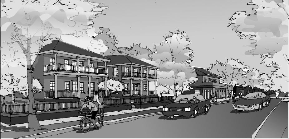

Newtown Pike Extension
Corridor Plan
Lexington, Kentucky
CHAPTER 6
Topics:
1. Circulation Systems
2. Streetscape Improvements
3. Parks and Open Space
4. Sidewalks, Curb and Gutter
5. Storm Sewer System
6. Fire Protection
This chapter addresses improvements to a variety of elements that make up the infrastructure of the neighborhoods within the planning area. These include circulation systems, streetscape enhancement, wayfinding signs, sidewalks, curb and gutter.
Circulation systems include those for automobiles, public transit, pedestrians and bicyclists. In some cases, streets are shared by a mix of these modes of transportation. In others, dedicated sidewalks, bike lanes and even separated trails complement the street system.
The most significant circulation improvement is, of course, the construction of the Newtown Pike Extension. This will enhance traffic flow and reduce congestion, while also improving access to jobs and services for area residents. However, several other improvements should also be planned. These tend to focus on the major arterials within the planning area. Within the individual subareas, traffic should be “calmed” by managing access points, controlling turning movements and generally designing streets for speeds and volumes compatible with the priority land uses.
Broadway Circulation Improvements
For the most part, the portion of Broadway within the planning area is constrained in its cross-section, and yet traffic volumes are projected to continue to increase. Turning movements into anticipated redeveloped sites will add to the circulation issues. If, for example, a grocery were to be constructed at the corner of Newtown Pike and Broadway, a left turn for traffic arriving from the south would be desirable. However, no space exists within the current curb layout. The street includes two travel lanes in each direction, and no on-
Newtown Pike Extension Corridor Plan Lexington, Kentucky
street parking lanes exist. The feasibility of widening the street to accommodate a turning lane and to add landscaping should be reviewed. This cross-section could be consistent with the wider configuration that exists on Broadway farther to the north, to the extent possible.
The section of Versailles Road that lies within the planning area presents a special challenge. Because it is an elevated structure for a substantial portion and lacks landscaping or activities that frame the roadway, it is uninviting to pedestrians. This particularly affects the Speigle Heights neighborhood, with respect to access to services in the downtown and within the planning area itself. Opportunities to enhance the streetscape and to provide links to other parks, bus routes and trail systems should be considered. (A landscape median is proposed for the lower portion of Versailles Road.)
A landscaped median is proposed for a portion of Versailles Road near the Newtown Pike intersection. The extent of landscaping that is feasible will be constrained by the bridge construction for a part of this segment.
The existing street section should be continued in this segment of Manchester. This includes two travel lanes and one lane of on-street
parking. Streetscape improvements along Manchester Street would include trees in grates along the sidewalk edge. On-street parking would be provided along the west side of the street.
Merino is an important circulation link within the Davistown and Woodward Heights neighborhoods. It should provide convenient access for neighborhood residents to resources within the neighborhoods, while also linking the area with the downtown core. However, while the street should be designed to accommodate local traffic, through traffic should be discouraged.
Enhance auto access to sites where development is targeted.
Although minimizing curb cuts is a general objective in order to facilitate traffic flow, some are needed to provide access to some of the targeted redevelopment sites; and, to some extent, they “calm” traffic. Design guidelines for providing access to key redevelopment sites should be provided.
A key concept of the Newtown Pike extension is that it will be a parkway-type street that balances the functions of moving traffic and at the same time serves as an urban street adjacent to residential areas and as a bike trail and future transit corridor. Although curb cuts tend to slow traffic, there are instances where curb cuts should be permitted. These should be considered on a case-by-case basis, where the principle of reducing turning movement and improving the pedestrian environment are the criteria. In general, using shared driveways and internal circulation should reduce the number of curb cuts. Cross-property access should be encouraged.
A key objective is to promote the use of alternative modes of transportation, in order to reduce automobile miles traveled within the planning area. As a means of doing so, key pedestrian and bike routes are enhanced and others are developed. The primary ped/bike route runs along Newtown Pike Extension itself. Dedicated bicycle lanes are designed to accommodate bicyclists and planting strips separate sidewalks from traffic to encourage their use. This route should serve as a “green circulation corridor,” which links a series of commercial and residential infill sites, along with pockets of open space.
Newtown Pike Extension Corridor Plan Lexington, Kentucky
Provide improved pedestrian and bicycle links to key resources and destinations.
Bicycle lanes should be provided on the Newtown Pike Extension. Key routes are along the parkway itself, as well as Manchester and Broadway. In addition, other secondary streets serve as pedestrian routes into the downtown, the University of Kentucky, area parks, community centers and neighborhood shopping, and these connections should be enhanced.
Newtown Pike Extension is a primary trail in the proposed Greenway Master Plan and will link into the community-wide network. It should fit into the Master Plan’s tertiary trails concept for neighborhood connections.
Shelter
Crosswalks of scored and dyed concrete Auto pull-out for drop-offs
Newtown Pike
Coordinate pedestrian and bicycle system improvements with regional trail plans. The key trail connection will be with the Town Branch Trail. However, the bulk of the trail segment that runs through the planning area is likely to occur in a later phase of implementation of this plan. Nonetheless, other circulation improvements should be planned to anticipate the trail; and, where feasible, trail segments should be installed with earlier development projects.
Specifically, a segment of the trail should be installed that would link Newtown Pike with the properties on the north side of Manchester. In essence, these properties should be redeveloped to be “double fronted,” orienting both to the street and to this trail segment. This segment should continue under the parkway and link with the parking lot at Lexington Center. This will facilitate sharing of parking resources and help to stimulate redevelopment along Manchester.
A special issue is the trail connection at the intersection of Newtown Pike Extension and Manchester Street. While the trail is planned to use the sidewalk system in the downtown core, it is projected to drop down to the Town Branch itself in the west parking lot of the Lexington Center. If this occurs, an underpass will be needed to maintain continuity of the trail between that starting point and the portion of the trail to the west, behind the buildings on Manchester.
Various cross-sections are presented in this section to illustrate the design character of certain streets in the planning area. The approximate locations of these road sections are shown on Map #25 in Appendix A.
Link the gateway at Main and Newtown with the neighborhoods within the planning area.
Enhancing this connection will encourage pedestrian access to downtown via Main Street from the neighborhoods within the planning area.
Link parks and community centers with improved pedestrian routes.
Providing good pedestrian connections to parks is important. An essential key link is one that would connect the northern portion of Davistown with Southend Park. Enhanced pedestrian crosswalks should be installed to link neighborhoods on either side of the parkway, particularly at High and Patterson Streets.
Other pedestrian route improvements:
Pralltown Pedestrian Trail
Develop the segment of abandoned railroad right-of-way that links Pralltown to Broadway as a pedestrian route. This will facilitate access to new services that would be developed in this area for Pralltown residents. This improved accessibility would become a part of the University of Kentucky’s campus planning effort.
Maxwell Street
Enhance the streetscape along Maxwell Street to encourage walking into downtown, particularly the location adjoining the Civic Center parking lots.
The Newtown Pike Extension is designed to support neighborhood development objectives, which vary along the route. Some portions are planned to be extensively landscaped, to convey a “parkway” quality. Other segments are intended to be more “urban,” with storefronts aligned at the sidewalk edge. The variables employed in the design include the width of the street, treatment of on-street parking and landscaping. In each case, travel lane widths should be sized to create a pedestrian friendly environment, while meeting functional requirements. A description of the various planned street sections follows. Note, however, that variations in these design concepts will occur as the design continues to be refined. (The locations of these typical street sections are identified on Map #25.)

The main segment of the Newtown Pike Extension between Main and Patterson Streets includes a landscaped median. Two travel lanes are provided in each direction. Bicycle lanes are positioned next to the curb, and a planting strip buffers sidewalks on either side. No on-street parking is provided in this portion of the road. Buildings along this segment should reflect traditional residential setbacks in most cases. A typical setback of 30 feet, from the back of the sidewalk to the face of a building, is recommended. At corners of major intersections, however, some commercial or mixed use buildings are proposed, which should sit closer to the sidewalk edge. The overall right-of-way width is 110 feet.

The segment of the Newtown Pike Extension immediately north of Broadway is to be more urban in experience. This character extends northerly to the intersection with Patterson Street. Here, commercial uses should be at the street level, with storefronts that align at the sidewalk edge. One travel lane is provided in each direction, as well as bicycle lanes. A landscaped median continues down the cen-
Options for providing a median along Scott Street, from Limestone to Broadway, may become available with current University planning and should continue to be explored. Some additional on-street parking may also be possible in this scenario.
ter. No parking is provided on street in this segment. Street trees are to be located in grated openings in the sidewalk. The overall rightof-way width is 90 feet.
Although no on-street parking is provided in the cross-section shown for Section B, there should be a thorough study of an alternate that provides on-street parking between Broadway and Patterson. Onstreet parking would do a superior job of slowing traffic, improve safety for both pedestrians and bicyclists, and create a truly urban street. Due to the very likely conditions of existing buildings remaining on each side of the street, this could mean that portions of the landscaped traffic median would be eliminated and appropriate transitions designed for each end of this section. Planned sidewalk widths in this section should be maintained in all cases.
The Scott Street Connector is a narrower width. It includes one travel lane in each direction and also provides on-street parking on both sides. No median is provided, but continuous on-street bike lanes are planned for the entire length of Scott Street to the University of Kentucky. Residential buildings on the northern side are set back, with yards, whereas buildings on the south side generally have commercial uses at the street level and should be positioned at the sidewalk edge. Trees are located in grated openings in the sidewalks. The overall right-of-way width is 64 feet.

This mid-section of Scott Street is a transitional link in which site constraints influence the design. It also has two travel lanes, with no median. Parking is provided only on the northern side. Trees are located in grated openings in the sidewalks. The overall right-ofway width is 56 feet.

The portion of Scott Street between Broadway and Limestone also has two travel lanes, without a median. The width of this section is constrained in some locations by existing structures. Therefore, the

use of on-street parking varies, depending upon the width available. Some landscaping is provided in islands that define on-street parking places. The overall right-of-way width is 56’ feet.
Broadway Bridge Design
There is a special opportunity to incorporate the bridge design with the streetscape theme. Attention should be paid to the bridge’s exterior treatment, approaches, lighting and its relationship for pedestrians and bike riders being located next to the existing railroad trestle. The bridge’s overall appearance should incorporate compatible colors, textures and hardware with the overall streetscape as well as possible landscaping at the approaches.
Streetscape improvements should be organized in a hierarchical structure, which reflects the types of uses that occur along individual streets. Improvements at selected intersections are also organized as a series of gateways and major intersections, which reflect the role that these places play in defining the downtown environment and in identifying individual neighborhoods. Major gateways into the area, therefore, should have more extensive landscape treatments, whereas less active intersections should be more modest.
A streetscape design “vocabulary” should be used that can help to establish an identity for all of the downtown area at large. This should draw upon the design traditions of Lexington and the Blue Grass region in general. At the same time, special “accent” features should be installed that distinguish individual neighborhoods within the planning area. These should be simple in character and in keeping with the downtown, urban nature of these neighborhoods. Overall, these elements should convey an enduring, “timeless” quality.
The streetscape palette should include these elements:
Crosswalks
A textured pattern should be created with concrete that is scored and dyed to distinguish it from the roadway itself. This treatment should be used for all crosswalks in gateways and at key intersections. In other locations, where pedestrian volumes are less intense, painted stripes are sufficient.
Town Branch Trail
Key Intersection at Newtown Pike and Manchester
Potential adaptive reuse of existing warehouses
ManchesterManchester Manchester Street Street Street Street
Street trees
Streetscape improvements along Manchester Street would include trees in grates along the sidewalk edge. On-street parking would be provided along the west side of the street.
Public art
Public art should be installed at gateways and in small plazas that may occur throughout the area. This will help to impart a distinct identity to individual locations. In many cases, these should be sponsored by private enterprises in the area.
Sidewalks
Concrete sidewalks should be provided throughout the planning area. In the “urban areas,” which generally include commercial at the street level, these are attached to the curb. In the more residential areas, planting strips should separate the sidewalk from the curb where space permits.
Street lights
The Urban County Government has adopted an acorn-style antique street light for the downtown core. This same street light should be extended along Newtown Pike, Main, Manchester, Versailles and Broadway within the planning area.
Street trees
Street trees are proposed to be installed as part of the linear streetscape designs.
A series of public signs should be installed. These should help to direct users to facilities in the vicinity as well as give overall identity to the area.
Develop gateways that highlight entries into the downtown at large. These include special landscaping, entry signs and street furniture. They serve to identify key entry points and also to provide a reference point for adjoining development.

Each gateway should be custom designed to respond to the context, but with the overall objective that the effect should be one of “announcing” entry into the area. The landscape palette should convey a sense of connection to the greater downtown as well. The following design elements should be incorporated, as conditions permit:
Textured and colored concrete crosswalks are to be used, as described above.
Flag poles may be used to carry banners to add color in gateways. They are effective for viewing at a distance.
Textured and colored concrete is installed within the intersection itself. This should have a color and texture that is different from that of the crosswalks. In addition, the middle of the intersection may be used as a location for public art.
These should be constructed of cut stone. They may be used to define pedestrian routes at the corners and they may also support directional signs or interpretive information.
Planters
Masonry planters may also be used at gateways.
Trees
Trees may be included in some gateway designs. They are effective as a backdrop to smaller scale design elements, where no background building exists.

Gateway Locations:
• The intersection of Main and Newtown Pike
• The intersection of Broadway and Newtown Pike
• The intersection of Newtown Pike and Limestone
• Newtown Pike and Versailles
Potential new civic building
Crosswalk Center paving
Corner paving
A gateway plan concept is illustrated here for the intersection of Newtown Pike and Main Street. Decorative paving defines crosswalks. A different paving design is used in the center of the intersection, and may include custom designed thematic elements or public art.
Key intersections convey a streetscape palette similar to that of the gateways, but at a lesser scale. Public information at these points identifies resources within the abutting neighborhoods. Decorative crosswalks are also included.
Textured and colored concrete sidewalks are used in these intersections. However, the middle of the intersection remains undecorated.
Key Intersection Locations:
• Newtown Pike and Patterson Street
• Newtown Pike and Manchester
These linear streetscapes are designed to enhance the use of alternative modes for transportation by encouraging pedestrian activity and enhancing the driving/cycling experience. Landscaping and related site amenities are planned that help to define the pedestrian zone, enhance safety and provide a more appealing environment. They also will enhance neighborhood identity and will help to attract other investment to these targeted areas.
Linear streetscapes include trees, sidewalks, curb and gutter. Along commercial corridors, trees are to be located in grates within the sidewalk. For streets with a more residential (or parkway) character, sidewalks are separated from the curb with a planting strip, and trees are to be located within that feature.
Areas of decorative paving are also included in some streetscape treatments. These are generally located at nodes where commercial activities are planned.
They also are visually related to the design palette used in the gateways and key intersections.
Linear streetscape locations:
Linear streetscape improvements are proposed for the following locations:
Along Manchester Street
The purpose of this section is to stimulate reuse and redevelopment of existing industrial properties with special commercial and mixed use activities. These streetscape improvements should link with the proposed pedestrian underpass at Newtown Pike and Town Branch Trail.
Along Broadway
Streetscape enhancement along Broadway should be achieved by widening sidewalks, when feasible. This may occur as properties redevelop.
Along Maxwell
The edge of the southernmost parking lots of the Lexington Center is barren and has a negative impact upon the Woodward Heights neighborhood. It also discourages use of this street as a pedestrian route into the downtown core. Streetscape improvements along this edge should be a high priority. In the long term, other compatible uses, including perhaps residential and commercial, should be introduced here to establish a buffer to the parking lots and to animate the street.
Streetscape improvements for neighborhoods within the study area should be encouraged. These improvements may include stone posts, or signs announcing boundaries of neighborhoods or historic important features.
The streetscape design of the extension should incorporate a neighborhood identity feature for neighborhoods/districts bordering the extension. It is not intended to be overt but instead a subtle if not elegant feature(s) that uniquely reference the character of the neighborhood by incorporating such elements as cornerposts, fences, walls, signature infrastructure, ground surfaces and/or signage that creates a distinct identity.
The proposed streetscape improvements described in the preceding sections are depicted conceptually on the illustrative Streetscape Plan, Map #26, with the focus on improvements along Newtown Pike Extension. Treatments for gateways and key intersections are combined with linear streetscape concepts, and the general locations of street intersections also are shown. Note that the actual design will vary from this sketch plan as details evolve. This is intended to reflect the character and intent of the streetscape improvements.
Transit system improvements also are anticipated as a part of the Newtown Pike Extension. The new road itself will provide an opportunity to improve bus routes in the area, and space is available to install future bus stops with shelters. Pedestrian connections to these will be enhanced by the landscaped sidewalks along the parkway as well as improvements along other streets in the area. This will further encourage use of transit stops.
Other than the planned drop-off facilities shown on the urban design plan, the right-of-way acquisition for the Newtown Pike Extension should reserve land to install future bus stop shelters along both sides of the new roadway. The general LexTran standards should provide for an 8 foot by 12 foot pad adjacent to the outside of the sidewalk. These reservations for future stops should be located approximately every quarter mile and at least 200 feet from the centerline of an intersection. Final plans will be coordinated with LexTran. Bus pullouts will not be required in these locations.
Improve existing parks in the area and expand them, where appropriate.
Upgrades to other parks also should be executed. These include improving accessibility, providing play equipment, ball fields and shelters. The Parks Department has developed a list of specific improvements for each park in the planning area and these should be implemented. This list is summarized in Chapter 3, “Existing Conditions.”
In addition, a significant reconfiguration of Southend Park is proposed. This redesign of Southend Park would better meet community needs, by providing an improved ball field and making use of other land more appropriate for housing. It is positioned to make use of lands near Versailles Road. It also is more directly accessible by residents of the Irishtown area.
Design parks to assist with regional drainage strategies, where feasible.
Again, Southend Park is a priority because it is tied to mitigation of road impacts. With the redesign of the park, detention can be improved.
Improvements to sidewalks, curb and gutter should be scheduled as a part of the capital improvements program for the area. In addition, priority should be given to these infrastructure improvements when they coincide with projects associated with the Newtown Pike Extension or with other targeted opportunity sites.
Storm water management for the lower Davistown Area will be enhanced with the implementation of the Urban Village concept. At present, a concrete box culvert is located in lower Davistown Area, which operates as the conveyance system for storm water runoff from neighborhoods, the University of Kentucky, and a portion of downtown Lexington, which are all located to the east. This box culvert also functions to collect all the runoff from the lower Davistown Area. With the implementation of the Urban Village, two possibilities exist. This box culvert could be isolated, providing only
for conveying runoff from other areas and a new collection system could be constructed to collect runoff and transport the water to the Town Branch. Another alternative would be to make minor improvements to the existing box culvert to improve conveyance capacity and provide saddle detention for large storm events. Any changes to the conveyance system must consider downstream drainage and will need further investigation.
For any new development in the study area, water lines along existing streets will need to be assessed to ensure they meet required flows. If not, a larger capacity line would need to be installed. Where new roads were being configured, water lines would need to be installed and linked to existing water mains in the vicinity. Major water mains in the potential Urban Village redevelopment area include Pine Street, Valley Avenue and South Broadway, as well as water storage units on Cox Street.

Newtown Pike

Extension Corridor Plan
Lexington, Kentucky
Chapter 7.
Organization and Phasing Strategies
Chapter 8.
Funding Strategies
Newtown Pike Extension Corridor Plan
Lexington, Kentucky
CHAPTER 7
Topics:
1. Organizations
2. Time Frame for the Plan
3. Environmental Justice Considerations
Introduction
A team effort among governmental agencies, nonprofit organizations and individual property owners and investors will be needed to facilitate the recommendations of the Corridor Plan. This involves working with existing organizations and individuals, as well as establishing new organizations. For existing organizations, establishing projects within the area as priorities and shaping existing operating procedures to better deliver plan recommendations will be needed. This includes staff of the Urban County Government, as well as private organizations.
It is important to stress that successful plan implementation will require leadership. This can come from many sources, but will most likely be the Urban County Government taking the initiative.
In terms of implementation, key organizational needs are these:
For some redevelopment opportunities, several properties must be aggregated, in order to yield the most desirable result. State and local government entities may play this role, depending upon the circumstances.
Providing housing that will be available for lower income categories will require entities that can qualify for assistance or that operate without profit in order to reduce costs.
Developers capable of providing market rate housing that meets the new trends in urban residential markets will also be needed.
While many of the organizational recommendations focus on property improvements, another key role is to have an advocate work with neighborhood residents on matters related to neighborhood planning. This person can play an important role in the early stages of planning, as well as its execution.
Mixed use projects, which involve combinations of commercial and special industrial activities, are also proposed. Developers with an expertise in these special categories will also be needed.
Agencies and individuals who could assist in this process include a development authority, a development facilitator, a Community Development Corporation (CDC), Housing Trust, and a neighborhood advocate. The Lexington-Fayette Urban County Government should facilitate the development of such agencies and individuals by providing technical assistance, regulatory changes and, when feasible, financial help. The potential roles for each of these is described in this section.
An organization that can promote improvements which are executed in the interest of the neighborhood is needed. A model for this type of organization is a Community Development Corporation. This is often established to help guide specific residential projects, as well as other neighborhood enhancements. This can be a conduit for a variety of assistance programs, and can help facilitate efforts by other not-for-profit affordable housing organizations. A CDC is typically organized for an individual neighborhood, but it could include a consortium of neighborhoods, such as those within the planning area. Typical funding sources are Community Development Block Grants and the Urban County Government’s General Fund.
Typically, Community Development Corporations are run by professional staff or citizen boards who have undertaken responsibility for a defined area. A majority of the members of the board live in the community they serve, having both personal interest and knowledge of how to improve the district. Often these members include representatives from businesses and institutions, bringing resources and insight into the process. CDCs create opportunities for the community through a blend of commercial, industrial and residential initiatives, along with the support of financing, marketing and management tools.
With respect to the planning area and downtown Lexington in general, a Community Development Corporation is needed that can span many neighborhoods. It should include a coalition of afford-
able housing providers who currently operate in the community. In this respect, it should serve as the lead for a variety of affordable housing initiatives, as well as related projects that would enhance delivery of community services in the area.
An agency is also needed to manage the transfer of some properties for redevelopment projects that meet the objectives of this plan. It should be able to receive properties acquired in conjunction with the parkway project, as well as assist with assembly of land for other major projects. A development authority often plays this role.
A development authority is generally an entity legally separate from the local government, which exists to perform functions exclusively for and by authorization of the local government. It operates primarily in redevelopment project areas designated by a board of supervisors that determine yearly implementation projects. A director is responsible for implementing redevelopment plans and any other special projects. These agencies can acquire properties and often provide local funding for the development of affordable housing.
With respect to the Newtown planning area, a development authority is a likely mechanism to use where market-rate projects are contemplated, but that need special assistance in order to assure that the development reaches its maximum potential benefit to the community at large. It also may be useful as a partner working with a community development corporation, if assembly of land is necessary.
For example, it could coordinate assembly of property that otherwise may not occur, resulting in more limited development projects. The property may then be transferred to another entity for development. In some cases, the recipient may be another agency of the government, such as the housing authority; in others, it may be a not-for-profit affordable housing provider or CDC. In still other cases, the property may be transferred to a private, for-profit developer. This is especially likely for some of the mixed use projects that are envisioned, which could include some affordable housing.
In some of these cases, the cost of the land would be reduced, in order to make development feasible. In all cases, design guidelines would be established to assure that the resulting improvements meet plan objectives and are compatible with the existing neighborhood context.
The development authority may, before transferring a parcel, make improvements that would enhance its appeal for redevelopment. For example, it could remove hazardous materials or contaminants that are on site; or it may install new utilities, curb and gutter.
Funding for initial property acquisitions should be provided as a part of the mitigation for the highway impacts. These funds should be supplemented, to the extent possible, by other sources. (See the discussion of funding options in Chapter 8, “Funding Strategies.”)
Many housing assistance programs focus on renters. While these are a major part of the market, it is also important to promote housing ownership as a means of building equity. This is especially important for first-time buyers. An organization is needed that can provide such affordable, “for purchase” housing, and at the same time, build a reserve fund for additional housing development. A new mechanism for doing so is the “housing trust.” These organizations use strategies for equity sharing to assure that units they develop remain affordable, while also providing opportunities for an owner to build equity. Typical funding sources are Community Development Block Grants and the government’s General Fund. The Center for Community Change in Washington, D.C. sponsors the Housing Trust Fund Project, which serves as a clearing house of information on housing trust funds and provides technical assistance to interested organizations and agencies.
The local housing authority, along with nonprofit housing providers, should be consulted for their potential involvement in the development of affordable housing and the future management of individual properties or units. It is likely that some of the affordable housing to be developed in this area will be operated by the Lexington-Fayette Urban County Housing Authority.
A key resource in Lexington is the group of affordable housing providers who have worked hard to meet needs of low and moderate income residents. These groups will continue to play an important role in meeting housing needs city-wide, and especially in the planning area.
Government staff must be encouraged to cross departmental lines and focus on creatively combining their resources to realize the objectives of the plan. They should be rewarded for such efforts.
For the first few years of plan implementation, a single person should be responsible for coordinating execution of the various aspects of the plan. While many departments, agencies and individuals will be actively involved, it is important to have a clear line of communication with someone who can help to facilitate projects that meet plan objectives. This coordination could be considered a part of the road mitigation.
Finally, another key player is the Kentucky Transportation Cabinet. With their involvement in the construction of the Newtown Pike Extension and related mitigative actions, they are likely to be an important source of funding, as well as technical assistance.
It should be recognized that existing zoning does not correlate to the recommendations of the Corridor Plan in many locations. The Urban County Planning Commission should pursue government-initiated rezonings in some instances to minimize the occurrence of new development or redevelopment not in keeping with the plan. Due to the size of the area and the extensive rezoning procedures required under KRS Chapter 100, it will be very difficult to administer these rezonings with existing staff. It is therefore recommended that a rezoning consultant be engaged fairly early in the implementation process to facilitate rezoning at the direction of the Planning Commission.
Of course, many rezonings will initiate at the request of the landowner and be a major means of implementing this plan. The land use recommendations shown on Map 23 should be followed where possible. Each case should be evaluated on its merits to serve the plan principles and policies, as well as the land use element of the plan.
The following schedule from the Lexington-Fayette Urban County Government presumes that all Newtown Pike Extension design and construction activities will proceed as scheduled.
Newtown Pike Extension Corridor Plan Lexington, Kentucky
2002- Plan Implementation Planning, lead0
Ongoing Monitoring SystemNPE Staff Team
2003 Urban Village PlanPlanning, lead $125,000 CMAQ Grant NPE Staffto develop plan including infrastructure needs, etc.
2003 Regulatory Research &Planning, lead $25,000 Research needed Hire Rezoning Law & NPE Staffrezoning initiatives, Consultantpossible new zoning categories, interim land use controls, etc.
2003-4 Carver Center Parks & Rec, lead To be Coordinate with other area Rehabilitationand area agencies determined centers, such as Manchester Center, etc.
2003-4 Begin Urban Village Community Dev To be To include all redevelopment Plan Implementation(CD), lead & determined aspects, including NPE Staff Team infrastructure, etc.
2003-4 Hire Development CD To be Senior professional position Facilitator per determined that could also serve Residential Infill & citywide infill Redevelopment Plan development function
2003-4 Develop area Planning, lead & $25,000 Cost shown to hire a non-residential NPE Staff Team consultant and work closely design guidelines with neighborhood
2004 Develop FacilitatorTo be This element would infill/redevelopment determined likely have incentive package citywide application
2004 Develop project-type Facilitator
0 city facilitation priority criteria
2004-5 Develop NPE corridor Historic $40,000 for study
Various grant sources interpretive planPreservation, and CIP budget should be available to lead and Facilitatorto be determinedhire consultant, write plan and for construction costs
2004-5 Develop area Facilitator, lead & To be Emphasize non-LFUCG funding CIP inventory and NPE Staff team determined sources (e.g., Brownfield, initial CIP requests demo grants, dedicated fund sources, etc.)
2004-5 Begin project Facilitator
0 facilitation in earnest
A Corridor Plan, by its very nature, includes a mix of policies and actions that are to be executed over a wide span of time. Several actions can be enacted rather quickly, while some must precede others in order to be effective; and still other recommendations must await an increase in population or a growth in market base before they become feasible. In essence, the plan must place the recommendations into short-term, mid-range and long-range phases.
A key issue is the development of affordable housing in an initial phase. Ideally, a sufficient number of units would be in place to accommodate relocations associated with the road construction and its related mitigation work. Therefore, three time frames are established:
Short-term actions, which can be implemented prior to the opening of the Newtown Pike extension, are grouped in Phase 1. Many of these are programmatic in nature. During this phase, actions focus on updating regulations and building capabilities of organizations to help accomplish plan goals. Other key improvements in this phase are ones that should be executed prior to the opening of the parkway. For example, expanding housing opportunities for those who may be impacted by the parkway should occur early in the plan execution.
Other Phase 1 actions are ones that can make use of existing governmental programs and that are not directly tied to the construction of the parkway. For example, establishing a redevelopment authority that could assist with assembly of land could occur early in plan implementation. The Phase 1 time frame covers the first four years after plan adoption, which is assumed to be in late 2002. Therefore, this phase dates approximately from 2003 to 2007.
Work in this phase should focus on establishing the organizational structure that is needed, as well as executing development projects that must be in place before the road work can begin. It also includes facilitating independent development projects that are in concert with long-range goals. Examples are:
•Assemble land for redevelopment projects at key intersections along the parkway.
•Develop replacement housing for those directly impacted by the road.
•Redevelop residential areas as planned.
•Assist with other private sector projects that fit with plan goals.
•Establish organizations needed to implement plan objectives.
•Execute infrastructure improvements that are related to road construction.
This phase focuses on projects that should happen in conjunction with highway construction, or that will become viable because of the road. Mid-range actions, those that can immediately follow the opening of the parkway, are included in this phase. These are generally projects that would respond to market conditions based on current trends in demographics. For example, development of a commercial site at a key intersection of the parkway would occur during this phase as an immediate response to the new opportunities that increased traffic volumes would create. Other actions in this phase are ones that can be accomplished with the advent of new governmental programs. The time frame for this phase is approximately from 2008 to 2012.
Examples:
•Facilitate development at key intersections and opportunity sites.
•Promote additional residential development.
•Continue infrastructure improvements.
•Promote other commercial and mixed use development.
Finally, those recommendations that build on the preceding actions and reflect anticipated growth in populations and the economy are placed in Phase 3. This phase focuses on sustaining the vision for the planning area and executing projects that require a more substantial growth in the market to be viable. Many of these are simply incremental increases in intensity of uses established in the earlier phases. Some would be major projects that help to complete the long-range vision for the planning area. These Phase 3 items would date approximately from 2013 to 2022.
Examples:
•Continue pedestrian and bikeway system enhancements (Town Branch Trail).
•Promote phasing out of industrial uses and introduction of commercial and residential mixed uses to replace them.
Successful implementation of this plan requires a long-term commitment to its underlying concepts. Many of the proposals in the initial phase should be executed in conjunction with the construction of the Newtown Pike extension. However, if some of these cannot be achieved in this way, then incremental implementation will be necessary. This will require a long-term commitment on the part of the key players, especially the Urban County Government, to see that those remaining elements of the plan are faithfully executed.
State and federal laws mandate a review of impacts on the community of a road improvement project such as the Newtown Pike Extension. This was issued in Executive Order 12898, “Federal Actions to Address Environmental Justice in Minority Populations and Low Income Populations,” to all federal agencies in 1994. The fundamental purpose of the order is a reminder to identify, address, and avoid disproportionately high and adverse human health or environmental effects on minority and low-income populations and ensure compliance with Title VI of the Civil Rights Act. Specific consideration to Civil Rights and Executive Order 12898 is required in the Newtown Pike Extension for fair treatment of all residents in the project corridor. As a part of fulfilling that order, a draft report, with substantial detail in this area, is in development. Emerging from that evaluation are these key points:
Some properties that lie directly in the path of the road project have existing residences and businesses. These must be relocated to suitable replacement facilities within the same or a similar context.
Many other properties that are not in the direct path of the planned road are also affected by the project because of the traffic it generates and the development it will stimulate. Community enhancements are necessary to offset the indirect impacts of the road project.
The project will have some social and environmental impacts:
•Modest increases in air and noise pollution
•Increased traffic
•Residential and business relocations due to highway right-ofway
•Roadway may serve as a constraint between the eastern (upper) and western (lower) portions of the Davistown neighborhood
•Increase in land values as a result of new transportation corridor; could cause rental and homeowner relocations
•Unwanted attention to at-risk population
Although the project will bring many benefits to the corridor, the concerns noted above will be borne disproportionately by the lowincome residents of Davistown and, to a lesser degree, residents of Irishtown and Pralltown. The residents in these areas have expressed a strong desire to remain in their neighborhoods but are also wary of the impacts the highway may have upon them. In particular, there is a concern that plans for the roadway extension may force residents to accept changes without consultation and recognition of the impact the road may have on their quality of life.
Due to these issues and the potential impact on the lower-income neighborhoods, these environmental justice impacts must be mediated to the highest degree. Basic considerations included in the Federal Highway Administration standards include the provision of replacement housing for any residents displaced by the project. Ideally, this housing can be found in a timely manner such that the project can proceed, as residents are not required to move until such time that they have found a replacement dwelling.
In the event that comparable replacement housing cannot be found or is unavailable due to monetary constraints, there is a provision for replacement housing of last resort (RHLR). A number of factors are considered in relation to the provision of RHLR, such as the availability of housing in the project area and the resources available to provide comparable housing. Methods for providing RHLR include rehabilitation of an existing replacement dwelling, relocation and rehabilitation of a dwelling, or the purchase of a dwelling for the displaced person.
Newtown Pike
Extension
Corridor Plan
Lexington, Kentucky
CHAPTER 8
Topics:
1.Strategies For Public Funds
2.General Economic Development Recommendations
3.Local Government Funding Sources
4.State and Federal Government Funding Sources
5.Private Sources
The actions proposed in this plan will involve substantial amounts of investment from a variety of public and private sources. These include direct allocations as capital improvements, administrative costs and program operations. A variety of funding sources will be needed. Some key methods are described in this chapter. First, some general funding strategies are set forth; then, specific sources are described.
Public funds are limited, and must be used carefully, in ways that will expand the benefits yielded to the public at large. In many cases, public funds are used to construct basic infrastructure improvements, such as storm water systems, streets and sidewalks. In other situations, they may be used to develop a community service facility or to assist in private, not-for-profit entities in delivering affordable housing. These types of projects should be high priorities. There are occasions, however, where assistance in private, for-profit projects would occur in a way that would more strongly benefit the public. Some basic principles for the use of public funds are these:
Maximize the leverage of public funds.
In order to gain the most benefit of public dollars, they should be used to stimulate investment from other groups and individuals. Providing basic improvements to the infrastructure of a neighborhood, or assisting with construction of special site amenities, are examples of this technique.
Schedule infrastructure improvements to coincide with other construction in the area.
It is also important to coordinate the timing of capital improvement projects, such that one will complement another. Scheduling the
construction of a new sidewalk to coincide with placing utility lines underground is an example.
Public funds are typically allocated for capital improvement projects in neighborhoods. This may include reconstruction of sidewalks, curb and gutter, for example. The timing and amount of funds allocated to a neighborhood are usually established several years in advance. Special guidelines for the use of the funds may also be established.
While it is important to stay consistent with these long range planning principles, some flexibility is needed in order to be able to respond to an opportunity that may arise from another sector. If, for example, a development is proposed in the area that would help to meet the plan goals, being able to allocate public funds for infrastructure improvements in concert with the construction of the project would be desirable.
In a related strategy, improvements scheduled by one governmental agency should be coordinated with that of other governmental divisions. As an example, storm sewer improvement work may be synchronized with parks development to establish a storm water detention area.
Allocating public funds for community facilities, infrastructure and affordable housing is generally well understood as a public policy. There are cases, however, when using public funds in association with a market-rate project is justified to make it economically feasible, particularly for desired redevelopment, as described in Chapter 5, “Land Use Element.” With respect to providing assistance to such projects, funds generally should be allocated according to these priorities:
1.Assist with regulatory and programmatic incentives that may reduce development costs, but at the same time not adversely affect the surrounding neighborhood. This may include:
•Establishing a special financing district, such as Tax Increment Financing
•Providing a long-term lease for space that would help secure project financing
•Reducing property and sales tax
•Reducing development fees
•Relaxing parking requirements or other site development regulations
2.Assist with infrastructure improvements that will benefit the public at large, such as streetscape enhancements, as well as construction of basic utilities. This may include:
•Installing sidewalks
•Repairing streets
•Enhancing landscaping at gateways and key intersections
•Installing decorative street lights
•Placing utility lines underground
•Improving the storm water system
3.Assist with land acquisition. Assemblage may be the only feasible way for a redevelopment project to achieve its highest and best use for the benefit of the community. In some cases, the entity acquiring the land will reduce the price of the assembled parcel(s) in order to make redevelopment with private investment economically viable.
4.Assist with actual building construction. While building construction assistance will be more typically applicable for affordable housing development, there may be occasions where assistance is the key to including a mix of uses that would enrich the neighborhood, but that may not otherwise be feasible. This may be especially appropriate where affordable housing is to be mixed with other forprofit projects.
The degree of assistance that is appropriate will vary with the specific conditions of each development project, and must be evaluated on a case-by-case basis. Nonetheless, these priorities for assistance should serve as a guide in making those decisions.
Employ an “evolving markets” view that coincides with the different phases of plan implementation. Some of the development that is illustrated in the plan may not be feasible in today’s market; but if trends in demographics continue,
they will be so in the future. In this regard, the demand for multifamily residential development, mixed with neighborhood service commercial, is likely to increase. Therefore, the plan must accommodate short-term market opportunities that presently exist, while also anticipating a moderately greater density and more variety in uses in the future.
Public assistance should be focused on projects that help to achieve the long-range, best use of land in the area. Those projects that include a mix of uses, or higher densities, should be encouraged, for example. In addition, those projects that orient to their existing neighborhood context, as well as to the new roadway, should be supported. This may come in the form of assistance with more flexible zoning and permitting, infrastructure improvements and other methods, as outlined in the previous chapter.
Keep the broader downtown economic goals in mind. Development that enhances the operation and functioning of downtown should also receive priority in terms of support. Residential development, for example, should be encouraged because it will help provide housing opportunities for those who work downtown and will also strengthen the market for downtown businesses. Commercial ventures that complement those of the core should also be encouraged, as should civic uses and entertainment venues that contribute to the urban experience for downtown residents in general.
A number of incentive programs should be established by the Urban County Government to encourage redevelopment within the study area. These will be important both to non-profit as well as for-profit ventures. These programs should include financial, administrative and/or regulatory incentives. Examples include fee waivers (administrative), expedited review (administrative) and flexibility in requirements where appropriate (regulatory). Assistance with the implementation and coordination of brownfield site cleanup would encourage redevelopment of such sites that may otherwise be undesirable for investment.
LFUCG could assist in assembling parcels for redevelopment by allocating funds in its annual budget. In the past, land assemblage and land costs have prevented affordable housing projects, and this will be an issue. The ability to draw upon the general fund is likely to be limited because of the demands on this source. In some cases, funds specifically targeted for certain infrastructure improvements can, however, be targeted to help execute plan recommendations. In addition, LFUCG could provide support and incentives through issue bonds, or authorizing their use.
The purpose of the rehabilitation program is to provide affordable housing to lower income renter households throughout LexingtonFayette County. The program is available to nonprofit corporate providers of rental housing and provides non-repayable loans for a portion of the rehabilitation costs through the Division of Community Development.
Downtown Lexington and the Lexington-Fayette Urban County Government co-sponsor the Rental Rehabilitation program. It is focused on providing affordable housing in downtown Lexington. The Rental Rehabilitation program is open to any structure with rental units within the zoned downtown area.
Community Development Block Grants (CDBG) provide eligible metropolitan cities and urban counties (called "entitlement communities") with annual direct grants that the communities can use to revitalize neighborhoods, expand affordable housing and economic opportunities, and/or improve community facilities and services, principally to benefit low- and moderate-income persons.
CDBGs provide a flexible source of annual grant funds for local governments nationwide—funds that they, with the participation of local citizens, can devote to the activities that best serve their own particular development priorities, provided that these projects ei-
ther: (1) benefit low- and moderate-income persons; (2) prevent or eliminate slums or blight; or (3) meet other urgent community development needs. Grant funds are available based on a number of demographics, such as the poverty rate and housing age.
Community-wide Housing Rehabilitation
LFUCG supervises a county-wide housing rehabilitation program funded by CDBGs. The housing rehabilitation program provides loans and grants to eligible owner-occupants in the interest of eliminating substandard housing conditions county-wide.
Known as the HOME program, this is the U.S. Department of Housing and Urban Development’s most recent program to develop affordable housing. LFUCG uses the program funding to assist in the development of both rental and owner-occupied units. Through local programs, such as REACH and the Fayette County Local Development Corp., mortgage subsidies and 0% loans are provided to first-time home buyers. In addition, funds are used to assist forprofit and nonprofit groups in providing affordable housing opportunities.
Lexington-Fayette Urban County Housing Authority (funded through Housing and Urban Development)
Currently the Housing Authority manages 1,791 low rent units throughout Lexington. Public housing authorities have assisted in the coordination and development of many redevelopment projects throughout the country.
The federal government has a number of funding sources available for brownfield redevelopment (i.e., environmental cleanups and related mitigations). The Departments of Agriculture, Housing and Urban Development, Transportation, Commerce and the Interior, as well as the Environmental Protection Agency (EPA) all have programs designed to provide loans and grants to municipalities for brownfield redevelopment. There is further funding available from the EPA to assist with environmental justice considerations.
The Transportation and Equity Act for the 21st Century authorizes highway and highway-related programs through 2003. This initiative aims to improve traffic safety, while protecting and enhancing
communities and the environment. Significant features include flexibility in how states administer funds, with an emphasis on measures to improve the environment and a strong planning process. The TEA-21 program can fund improvements that enhance alternative modes of transportation, including pedestrian and bike trails. Adaptive reuse of historic buildings associated with transportation can also be included.
Federal Highway Administration
Road construction funds, including those associated with mitigation work, will also be a key funding source in the first two phases of plan implementation. Eligibility for mitigation funding of secondary impact areas is determined by an evaluation of cumulative effects made by the Federal Highway Administration. Low income portions of the study area that incur the most impact from the roadway project are most likely to warrant environmental justice consideration.
Federal Home Loan Bank
Programs available through the Federal Home Loan Bank, such as the Federal Home Loan Program, could assist local residents in attaining home ownership.
Housing and Urban Development (HUD)
In addition to the programs previously listed that are sponsored through HUD grants, many other programs are available through HUD. An efficient method of monitoring available HUD grants is to use the “Super Notice of Funding Availability” (SuperNOFA). This service announces the availability of program funds for housing and community development programs.
Kentucky Cabinet for Economic Development
The Kentucky Cabinet for Economic Development works in partnership with several organizations to offer assistance to communities seeking to design an economic development strategy for their area and to assist communities with business expansion and retention efforts.
Kentucky Housing Corporation (KHC)
A number of rental housing production funding programs are available, including the HOME investment partnerships; Affordable Housing Trust Fund; Risk Sharing - Tax-Exempt Financing; Kentucky Renaissance Funds and the Housing Development Fund. Home buyer
and rehabilitation funding is available through both the HOME and Affordable Housing Trust Fund (AHTF). The AHTF can be applied to acquire, rehabilitate or construct affordable housing.
The League of Cities provides tax-exempt financing to Kentucky cities. KLC has financed a variety of projects in the past, including water and sewer systems, community centers and parks projects. In addition, they have a FreshRate Program aimed at making it easier for state residents to buy a home by reducing up front funds needed to purchase a home.
While the superfund program generally supervises site cleanup, they may take a direct role in cleaning up a site where there is no responsible party. In particular, the Hazardous Waste Management Fund may be able to provide funding to remediate high priority sites.
In 1998, cigarette manufacturers reached a settlement with 46 states over claims against the tobacco industry. This Tobacco Master Settlement Agreement (MSA) includes payments to be made over the next 25 years. Kentucky is one of the states with the largest settlements, due to the intensity of state tobacco production. There may be an opportunity to utilize MSA funding for projects related to the redevelopment of warehouses formerly used for tobacco storage or related projects.
The University of Kentucky may be able to assist redevelopment projects in the vicinity of their campus. This support could be in the form of financial or design considerations, such as coordination and integration of any on-campus projects adjacent to the study area. They have been a generous source of medical and dental care at the Nathaniel Mission Health Clinic.
Local Corporations
Often local corporations are able to fund projects through financial support, donated goods and services. This is an opportunity for organizations to reinvest in the community.
Local Foundations
Various local foundations could fund particular projects or portions of projects as single entity funders or as part of a partnership of other groups.
Local Banks
Banks could provide low interest loans for nonprofit organizations, investors, and/or for-profit redevelopment interests.
Nonprofits
Partnering of nonprofit and for-profit developers or between grassroots sponsors and experienced nonprofits is another possibility.
Newtown Pike
Extension
Corridor Plan
Lexington, Kentucky
Appendix A
Map 1Study Area with Road Layout
Map 2Subareas
Map 3Interface Areas
Map 4Development Patterns
Map 5Topography
Map 6Drainage Conditions
Map 7Hazardous Material Concerns
Map 82000 Census Tracts
Map 9Existing Land Use
Map 10Future Land Uses from Comprehensive Plan
Map 11Existing Zoning
Map 12Existing Zoning Conflicts with Future
Comprehensive Plan Land Use
Map 13Roadway
Functional Classification
Map 14Accessibility Features
Map 15Off-Street Parking Locations
Map 16LexTran Routes
Map 17Key Existing Pedestrian Routes
Map 18Sanitary Sewer Lines
Map 19Curb and Gutter
Condition
Map 20Community Facilities
Map 21Historic Resources
Map 22Planned Circulation
Framework
Map 23Planned Land Use
Map 24Planned Land Use and Key Improvements
Map 25Parkway Alternates and Cross-Section Locations
Map 26AStreetscape
Illustrative A
Map 26BStreetscape
Illustrative B