

Mai Xiong
Landscape Narrative | Situational Urbanism
mai.xiong.20@ucl.ac.uk +44 7742781753 imagesofmai.com
EDUCATION
University College London
Master of Landscape Architecture - Merit
GPA: 3.73/4.0
Graduation Project: Memorial and Oblivion Landscape Heritage - the Bearer of Narrative and Memories
Thesis: Writing, Rewriting, Forgetting the Berlin Wall
The Embedded History in German Urbanscape
Hunan City University
Engineering Bachelor of Landscape Architecture
Overall GPA: 3.12/4.0
The First-Class Scholarship, University-Level, HNCU
The Second-Class Scholarship, University-Level, HNCU
The First Prize of Photography Competition in Yiyang, HN( Hunan Daily)
The Second Awards in National English Competition for College Students
EXPERIENCE
Landscape Intern, AURA Studio
Participated Concept Project: Lingang Project with Gensler, Shanghai, CN; Transition Planning of Disneyland (SITR), Shanghai, CN; Fortune Center, Shanghai, CN; Suzhou Lumu Old Street Renovation, Suzhou, CN.
Landscape Intern, GWP Architects
Participated Completed Project: Riding the Wind, Guangzhou, CN
Participated Concept Project: Industrial Park of the China Beauty City, Guangzhou, CN
Student Assistant, Smart City Technology Innovation Center, Urban Planning & Architecture Design Institute of HNCU
Engaged with Document Collation and Data Record of Regional Planning
DESIGN PROJECT
MEMORIAL AND OBLIVION Individual
Situational Landscape - An Expeimental Walk Design Studio 2 - Experimental Disruptions World War Ruins/Trauma/Narrative/Counter-Monument
ROAMING IN AGES Individual
The Urban Archeology Wonderland Design Studio 2 - Terrain Vague Urbanism/Heritage/Space/Archeology/Identity

THE REBIRTH OF MEMORY Individual
Transformation of Gasworks LA Studio
Brownfield/Post-Industry/Urban Renewal
ACTIVITIES
Participant in Drawing of the Year 2022, Archsource
Participant in The Architecture Drawing Prize 2002, WAF
Member of Landscape Research Group (LRG)
Student Member of American Society at Landscape Architects (ASLA)
Contributor at The Bartlett Autumn Show (The Bartlett)
London, United Kingdom 2020-2022
2021/2022 2021/2022
Hunan, China 2016-2020 2018-2019 2017-2018 2017 2018&2019
project CONTENTS
Scope through Provocation
Memorial and Oblivion
- Landscape as a Bearer of Narrative and Memories.
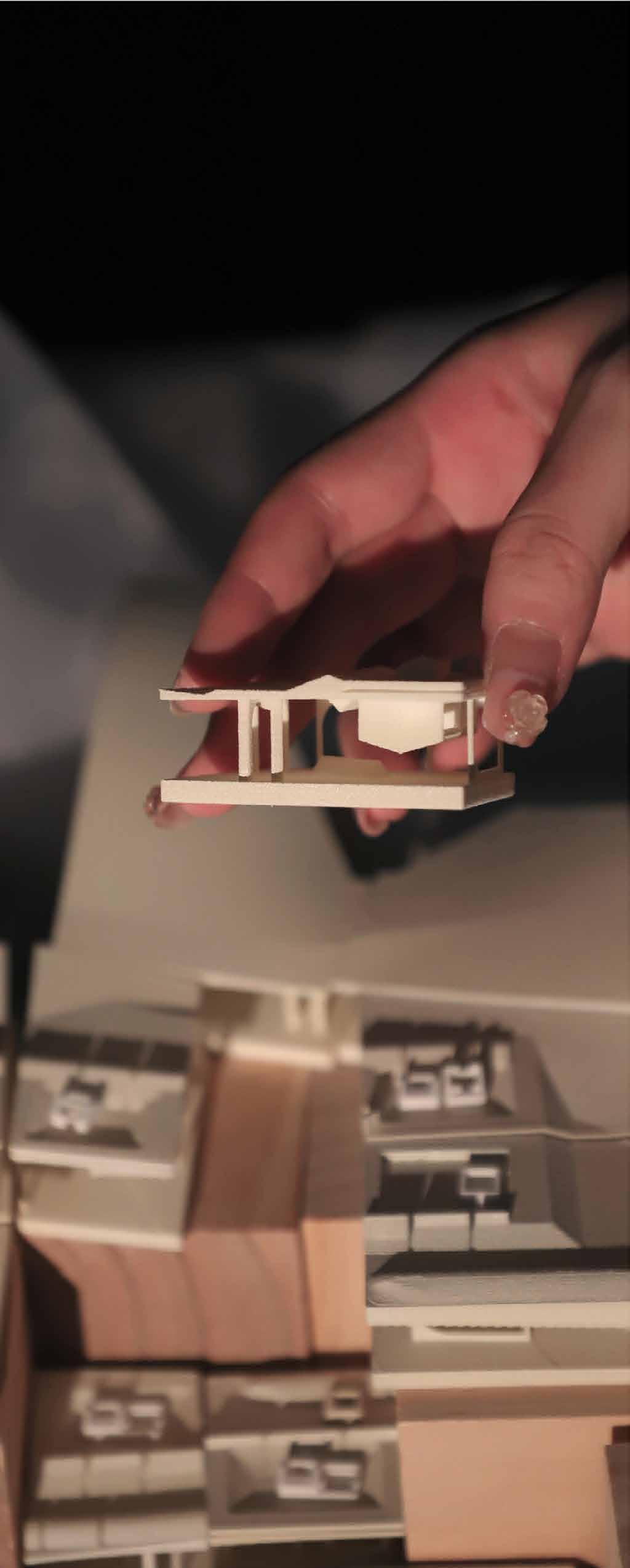
Satellite Mapping/ Dadaism Collages/ Information Master Plan Story Board/ Illustration/ Script/ Models
Shanghai, China 7/2021-9/2021
Guangzhou, China 7/2020-9/2020
Hunan, China 8/2018-1/2019
Royal Arsenal, London, UK Grade:A 10/2021-9/2022
Yiyang,Hunan, China Grade:A 10/2020-5/2021
Shanghai, China 8/2019-10/2019
2022 2022 20202020-2022 2020/2021; 2021/2022
SKILLS
Scope through Enlightment
Roaming in Ages - an Urban Archeology Wonderland.
Archive Drawing/ Anaylsis Diagram/ Palimpsest/ Illustration
22
13 Technical Report
Urban Archeology Park
Professional Works
Guangzhou Fengsheng 101 - GWP Architects - Commercial Landscape
Lingang Hi-tech Park - Aura Studio Shanghai - Office Campus
Ningbo Ming Lake - Aura Studio Shanghai - Civic & Public Landscape
31
Modelling
Image-Processing


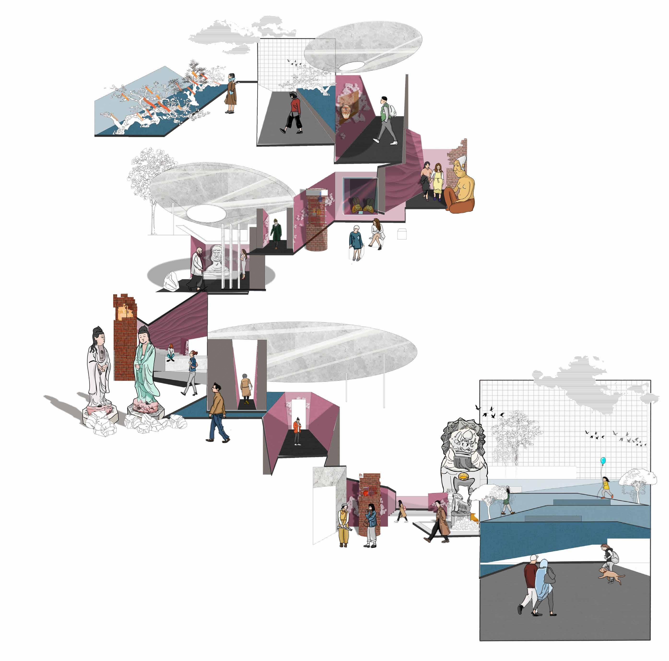
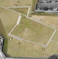
Rabbit Hill, an archaeological site excavated in 2003, located in Yiyang, China, comprises a large number of historical artefacts that reflect the beginning chapter in the city’s history. Like all developing cities in China, Yi yang is urbanising rapidly, homogenising both urban facades and culture. The discovery of Rabbit Hill seems to provide a chance to save the city’s history and cultural identity. The unknown heritage is remote from not only the surroundings and the whole city fabric, but also the local history.


Designed Notation

Interventions in landscape inhabitation would bring memories that buried in history back to people, to the modern times. Breaking the boundary means beyond the 3-dimentionals, it is more about the times that people could experience in history through juxtaposed ages.


As for the flat plan, rearranging the routes of the tour, connecting all the wells and pits.
In terms of 3-dimentional, below walkways stretch through the pits, of which up and down experience vertically according to the depth of each pit. The wells are exposed their layers and kept the original tex ture.
Regrading to the times, the 4-dimensional, the relics and antiques lie in their initial rooms, where protected by glass frames. Visitors watch through those artifacts and travel the pages of history…
“Notational Systems in landscape architecture enable one to consider the simultaneity of different layers of experience, including movement and time.”(James Corner, 1991)
Testing plan a b c d

e


Notation of the intenventions
Notation of each pit Symbolic artefact


Design process

The process diagrams shows the design development based on notation systems, and series of interventions enegaed. From the start ‘current status’, then recovering the original archeology features, removing the barrier(the wall), expanding it to the inside to be the deck and balcony for the whole community; reorganizing the routes according to ar cheology features, down to the ground, which creates vertical experience to find the heritage; dissembling the wells where exisiting antiques and relics, exposing their layers to visitors; as for protection, building up shelter(cano pies) to avoid relics from bad weathers, the shape of them depend on the wind and sunlight; at last, in order to correspond the historic atmosphere, the plants could be part of creates historic environment, bending the trees, making them like ancient ones.


There are the marked relics and wells in pits, providing messages to the visitors about the chronological products. Opening aisles and arranging visiting routes create better exhibition routes for people who are likely to find the ancient stories.


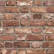
The walking systems is divided into two: the above’ and ‘the below’ which allows tourists to choose their own routes. The above plank path is from the west entrance, crossing the underpass and finally reaching the east exit. The underground path is paved by sustainable and traditional material, pebbles with rammed soil, as well the retaining wall. The planting reserves the empty with grass, ornamenting some shrubs and small arbors, attracting birds to build their own habitat.


Seasonal use in Spring: Neighbors celebrate the Spring Festival in the site, they pray under the trees and relax or walk through.
The Chinese Archeology Day is opening for tourists from all over the world. Local archeology institution holds a series of activities for popularizing archeology, which offers several imitative archeological pits and workbench for tourist to experience the whole process in archeology.
Proper time for pruning plants, the site is a winter garden for visitors to taste the various unique posture of those vagetation. At the same time,
The view from sunken way reflects the dynamic changing scene in people's motion and sight. The graph provides clues about visitor's position and the direction of view, as well as the events happened through a series of eyelevel views, including the antiques they may found. The mirror shelters(canopy) protects the relics in sunken space, refelcts sunken scene for people who walks on the surface and avoids them from bad weather.


Vision of seasonal use in the Rabbit Hill.
 PUBLIC PARK
WINTER GARDEN
ARCHEOLOGY HALL
PUBLIC PARK
WINTER GARDEN
ARCHEOLOGY HALL
THE RABBIT HILL is an archaeological site, located in Yiyang, CHINA. It was discovered during real estate excavation in 2003. The contents of these slips and tablets with writing are mainly registry records, offering data for the study of local government operations 2000 years ago. Therefore it is the birthplace of the city, in order to protect, the wall had been built by the government, aiming to mark the heritage site in a conservative way. However, the clear border is actually separating the site from the city as well the history..
So, for saving the forgotten place, plan to blur the wall and time. Beyond the edge, engaging each other, the site is a friendly neighbour. Beyond the age, below the ground, the site is storyteller.
SECTION1- Envrionmental Sysytem SECTION1 - Envrionmental Sysytem
SECTION2 - Landscape Inhabitation


The pits are recovered from the under-earth and renewal reorganized their layout and accesses with natural materials. In order to aware people of the site's history,


and antiques are originally preserved in their rooms. As for the surface walkway, it is lofted plank since the least damage of the grass land. Since artifacts are fragile and undetectable, mirror canopies could reflect them for viewers and protect them when facing rains.


Precipitation
The climate of the site is Subtropical Monsoon Climate, which represents the distinguishable season with abundant rainfall and active monsoon. Because of frequent rainstorm hazard, the site serves as reserve greenery for public recreation, furthermore, it has to possess the functions of rainwater collection and ecologi cal governance.


Shading Sundown Sunrise
in
is


since the site

site is surrounded by buildings with diverse height, therefore the shade could be drawing in this emptiness like a painter during the day and years.


Osmanthus fragrans (Thunb.) Lour.


Phyllostachys arcana McClure Castanea seguinii Dode


Ligustrum lucidum Ait.


Albizia julibrissin Durazz.

Platanus occidentalis Linn.

Platycladus orientalis (Linn.) Franco
Camellia japonica Linn.


Rosa multifolora Thunb Festuca
Ophiopogon japonicus (Linn. f.) KerGawl.
Fatsia japonica (Thunb.) Decne. et Planch.

Oxalis corymbosa DC.

Reineckia carnea(Andr.) Kunth

Loropetalum chinense (R. Br.) Oliver var. rubrum Yieh


SECTION3 -Landscape Realisation
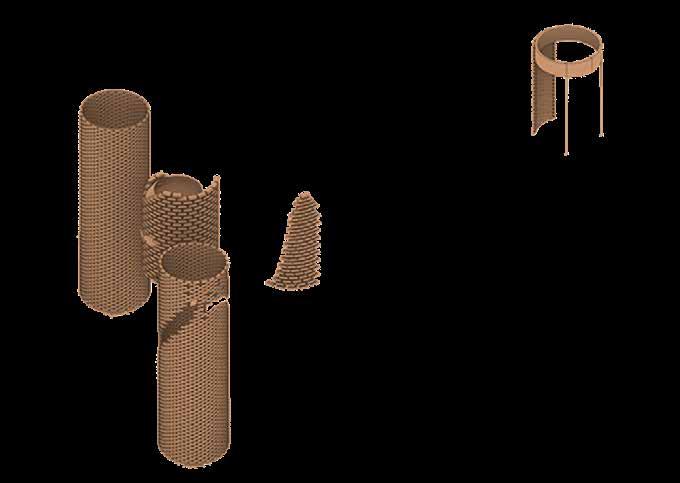
EXCAVATION
Since the protective measure had taken, the site had been backfilled three pits after archeology works finished and left only one who was covered by a pavillion, therefore its personalities and uniqueness are at a disadvantage. For fixing the DNA of the site, my intention is to recover all the pits that excavated during the archeological research period, hence return the artefacts back to their rooms and stories. The pits will become the resource space that exhibit the antiques, and also a area for Archaeology enthusiasts and researchers to further explore.

SECTION3 -Landscape Realisation


EXCAVATION


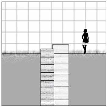
Gabion


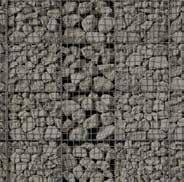
For maintaining the sunken soil, the retaining wall is necessary to be permeable and drainage-friendly. Gabion wall is made of stacked stone-filled gabions tied together with wire, which could build an environment more nat ural by steping back with the slope, rather than stacked vertically.
Since the city is well known for bamboo, local raw material can be able to replace with wooden plank and pav ing for walkways on the surface.


Besides, the gravel used consists of varing amount of crushed stone, sand and fines, which could be collected not only in the site itself but also in nearby constructions. Gravel pavement applies in sunken paths is beneficial the local rainfall permeation and filtration.


Central square is a gathering place in the whole tour, which contains exhibitions and facilities for people to visit and relax.

Bamboo plank Mixed


New rammed earth wall making Section of sample <Rammed earth with gravel > <Archeology pit > <Ground> <Dismantled well> <Bamboo plank> <Rammed earth wall> Rammed earth Debris 28 29


SECTION3 -Landscape Realisation


PLANTING
(Thunb.)
3-5 2-2.5 Shrub

Mod.dense 5-7 4-5.5 Dense leaf 6 3.5 Dense in leaf 8 4.5 Mod.dense 4 3 Fast-grown tree


in leaf

specimen dense trees that growing fast for people gathering and relaxing. At the same time, the wells that reserved completely are protected by the trees.
DRAINAGE


The site has been damaged by heavy precipitation per decades, it is unable to carry the overload rainfall during the tests in section1, therefore, all the materials that used for pavement and structure are supposed to be permeable and sustainable to deal with the predicted disaster. Due to the existing slope, the landform can be regulated dranage-friendly, the same as the canopies, which protected the sunken relics.
The 50-year rainfall level is almost reaching at 230mm, which indicates the larger drainage demand. Hence preserving as much as possible greenery, and utilizing the advantaged landform and facilities to support better drainage and sustainability. The two types of wells, displayed and reserved, the former one are protected under the canopy, the left one are reuse for reaching the aquiderous layer to be drainable.

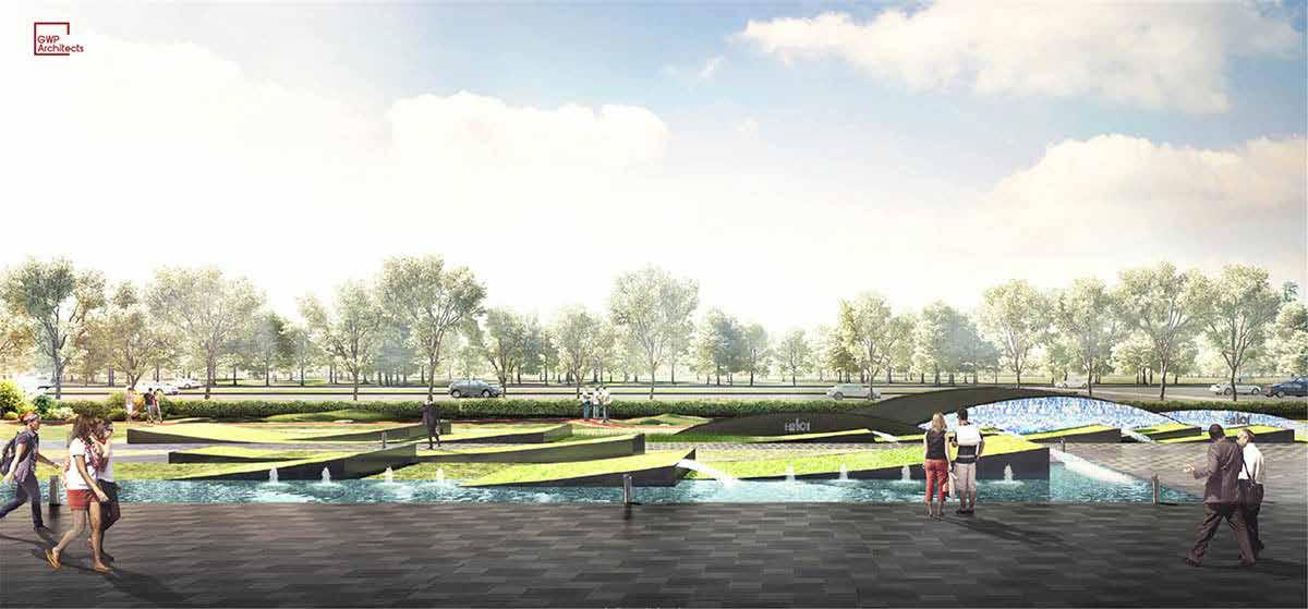
#Scope through Professional

2019 Internship GWP Architects


Concept Plan and Deeping Design


Name: Guangzhou Fengsheng 101 Location: Guangzhou · China Covering Area: 14000 SQM Team Leader: Vivian Cai Design Scopes: Master planning, Architectural design, Landscape design Awards: 2020 MUSE DESIGN AWARD: PLATINUM WINNER (UNITED STATES) 2020 ICONIC AWARDS: INNOVATIVE ARCHITECTURE-WINNER (GERMANY) 2020 WORLD DESIGN AWARD (GLOBAL) 2020 GLOBAL FUTURE DESIGN AWARD (GLOBAL) 2020 ASIA PROPERTY AWARD (ASIA) 2019-2020 ASIA-PACIFIC DESIGN COMPETITION-GOLDEN DIAMOND AWARD (CHINA) THE 5TH REARD GLOBAL DESIGN AWARD (CHINA) 2020 A&D AWARDS (HONGKONG,CHINA) 2020 IDA DESIGN AWARD (UNITED STATES) 2020 OUSTANDING PROPERTY AWARD LONDON (UK) 20212022 ASIA PACIFIC PROPERTY AWARDS (GLOBAL)


#Scope through Professional
2021 Internship - AURA Shanghai Studio Deeping Plan


Name: Lingang Hi-tech Park


Location: Shanghai · China
Project Type: Office Campus
Team Leader: Eva Garcia Pascual; Natchanop Achintharangkoon
Architectural Design: Studio Libeskind (USA), Gensler (Shanghai), GALA (Shanghai)

#Scope through Professional
2021
Internship - AURA Shanghai Studio Deeping Plan

Name: Ningbo Ming Lake
Location: Ningbo · China
Project Type: Civic & Public Landscape


Team Leader: Eva Garcia Pascual; Natchanop Achintharangkoon
Architectural Design: RMJM