

EDUCATION
University College London
Master of Landscape Architecture - Merit
GPA: 3.73/4.0
Graduation Project: Memorial and Oblivion
Landscape Heritage - the Bearer of Narrative and Memories
Thesis: Writing, Rewriting, Forgetting the Berlin Wall
The Embedded History in German Urbanscape
Hunan City University
Engineering Bachelor of Landscape Architecture
Overall GPA: 3.12/4.0
The First-Class Scholarship, University-Level, HNCU
The Second-Class Scholarship, University-Level, HNCU
The First Prize of Photography Competition in Yiyang, HN( Hunan Daily)
The Second Awards in National English Competition for College Students
EXPERIENCE
Landscape Intern, AURA Studio
Participated Concept Project: Lingang Project with Gensler, Shanghai, CN; Transition Planning of Disneyland (SITR), Shanghai, CN; Fortune Center, Shanghai, CN; Suzhou
Lumu Old Street Renovation, Suzhou, CN.
Landscape Intern, GWP Architects
Participated Completed Project: Riding the Wind, Guangzhou, CN
Participated Concept Project: Industrial Park of the China Beauty City, Guangzhou, CN
Student Assistant, Smart City Technology Innovation Center, Urban Planning & Architecture Design Institute of HNCU
Engaged with Document Collation and Data Record of Regional Planning
DESIGN PROJECT
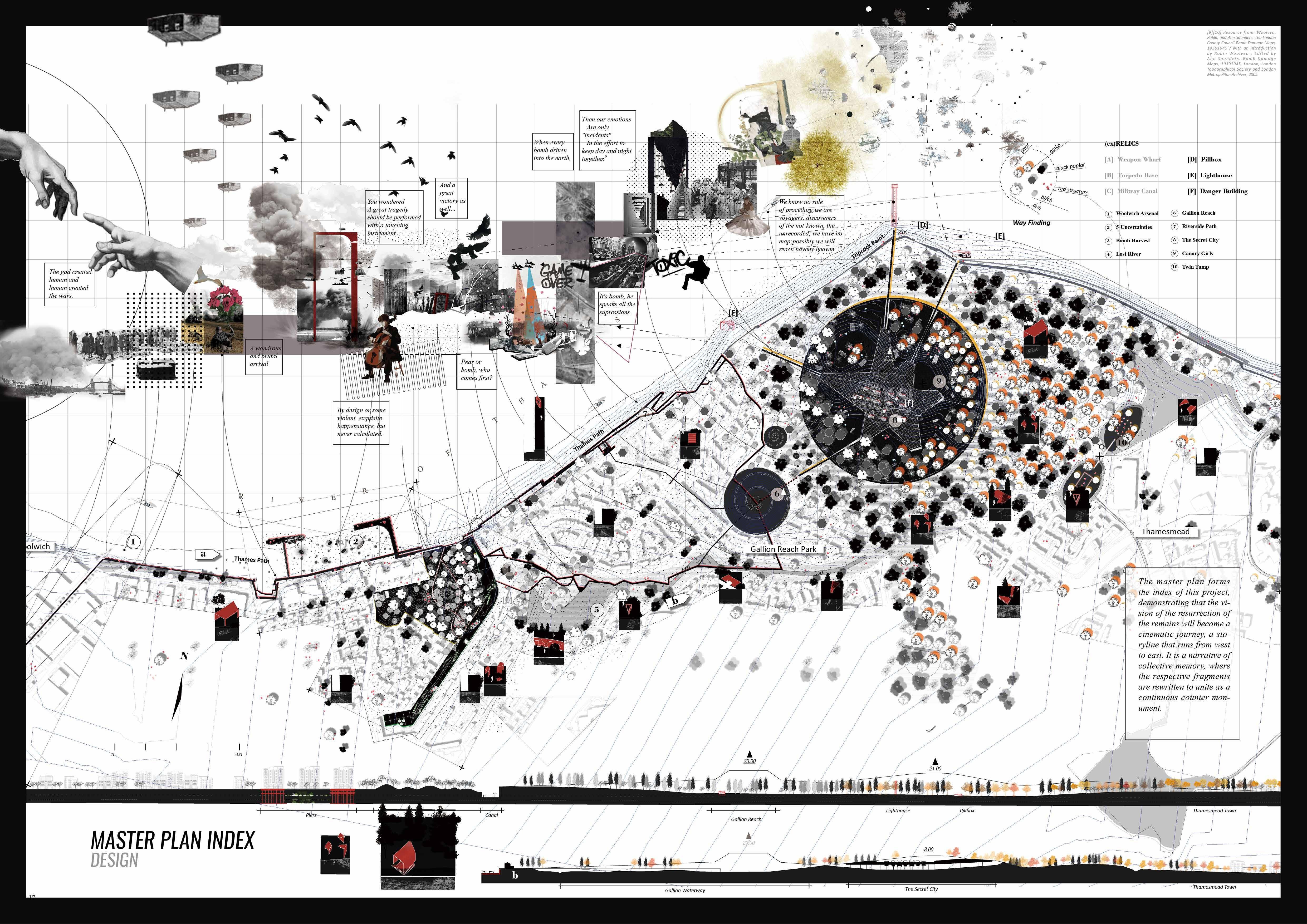
MEMORIAL AND OBLIVION Individual
Situational Landscape - An Expeimental Walk
Design Studio 2 - Experimental Disruptions
World War Ruins/Trauma/Narrative/Counter-Monument

ROAMING IN AGES Individual
The Urban Archeology Wonderland
Design Studio 2 - Terrain Vague
Urbanism/Heritage/Space/Archeology/Identity
THE REBIRTH OF MEMORY Individual
Transformation of Gasworks
LA Studio
Brownfield/Post-Industry/Urban Renewal
ACTIVITIES
Participant in Drawing of the Year 2022, Archsource
Participant in The Architecture Drawing Prize 2002, WAF
Member of Landscape Research Group (LRG)
Student Member of American Society at Landscape Architects (ASLA)
Contributor at The Bartlett Autumn Show (The Bartlett)
London, United Kingdom
2020-2022
2021/2022 2021/2022
Hunan, China 2016-2020 2018-2019
CONTENTS
Shanghai, China 7/2021-9/2021
Scope
Guangzhou, China 7/2020-9/2020
Hunan, China 8/2018-1/2019
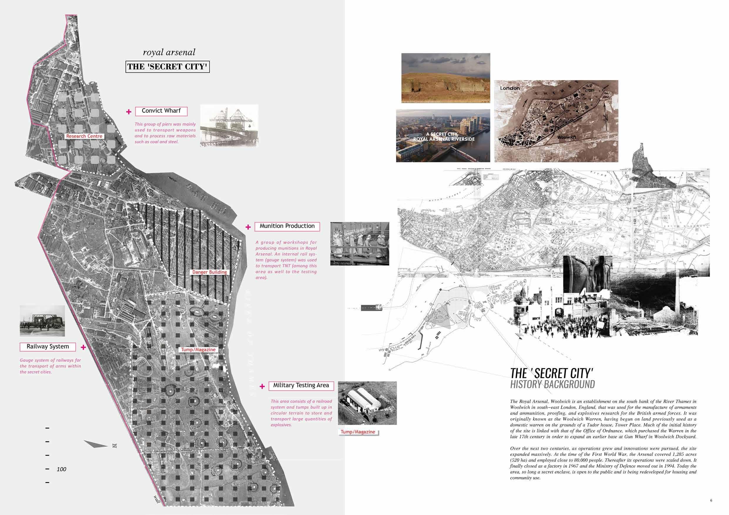
Royal Arsenal, London, UK Grade:A
Yiyang,Hunan, China
Shanghai, China
Lingang
Ningbo
Jiulongkou
01

#ScopethroughEnthnology
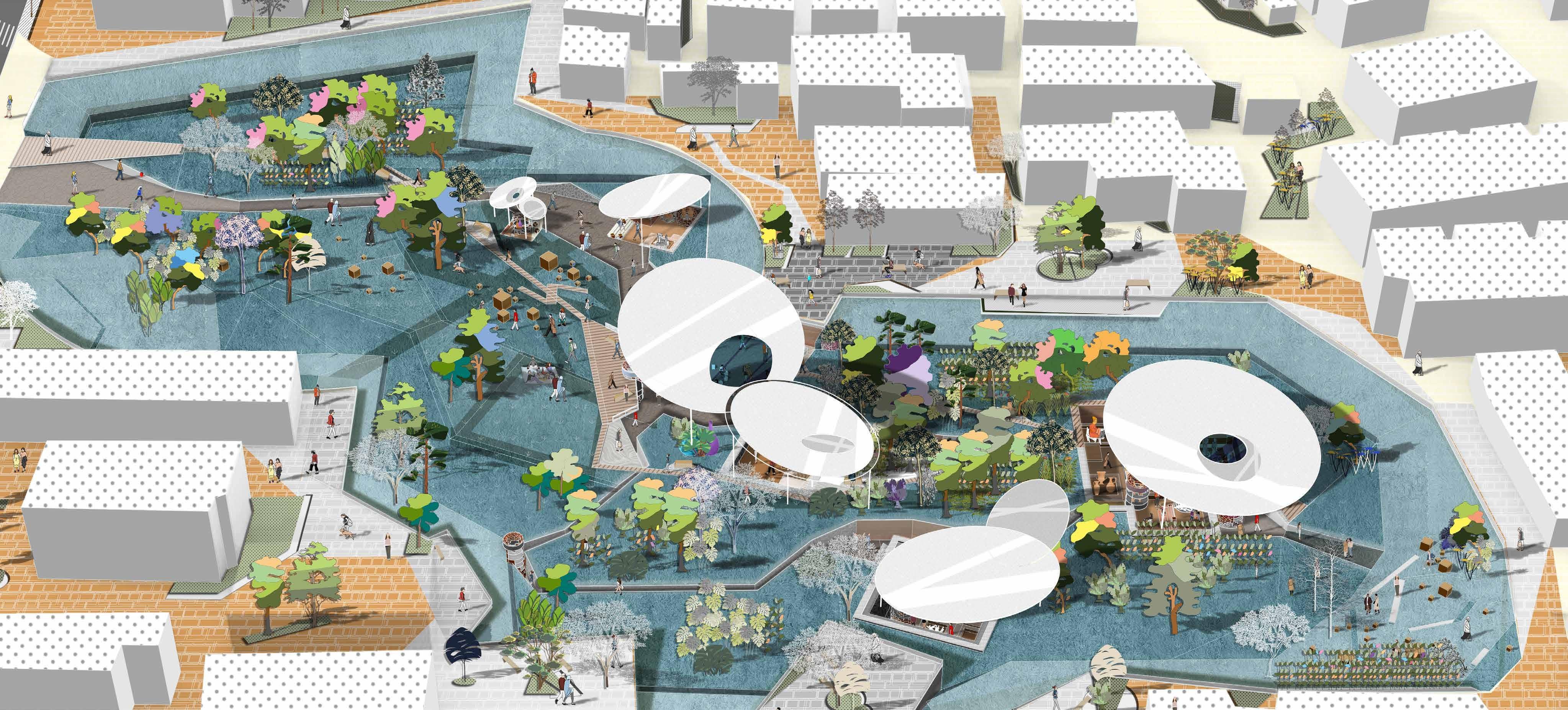
Ethnic Co-Habitat - Block Revitalization

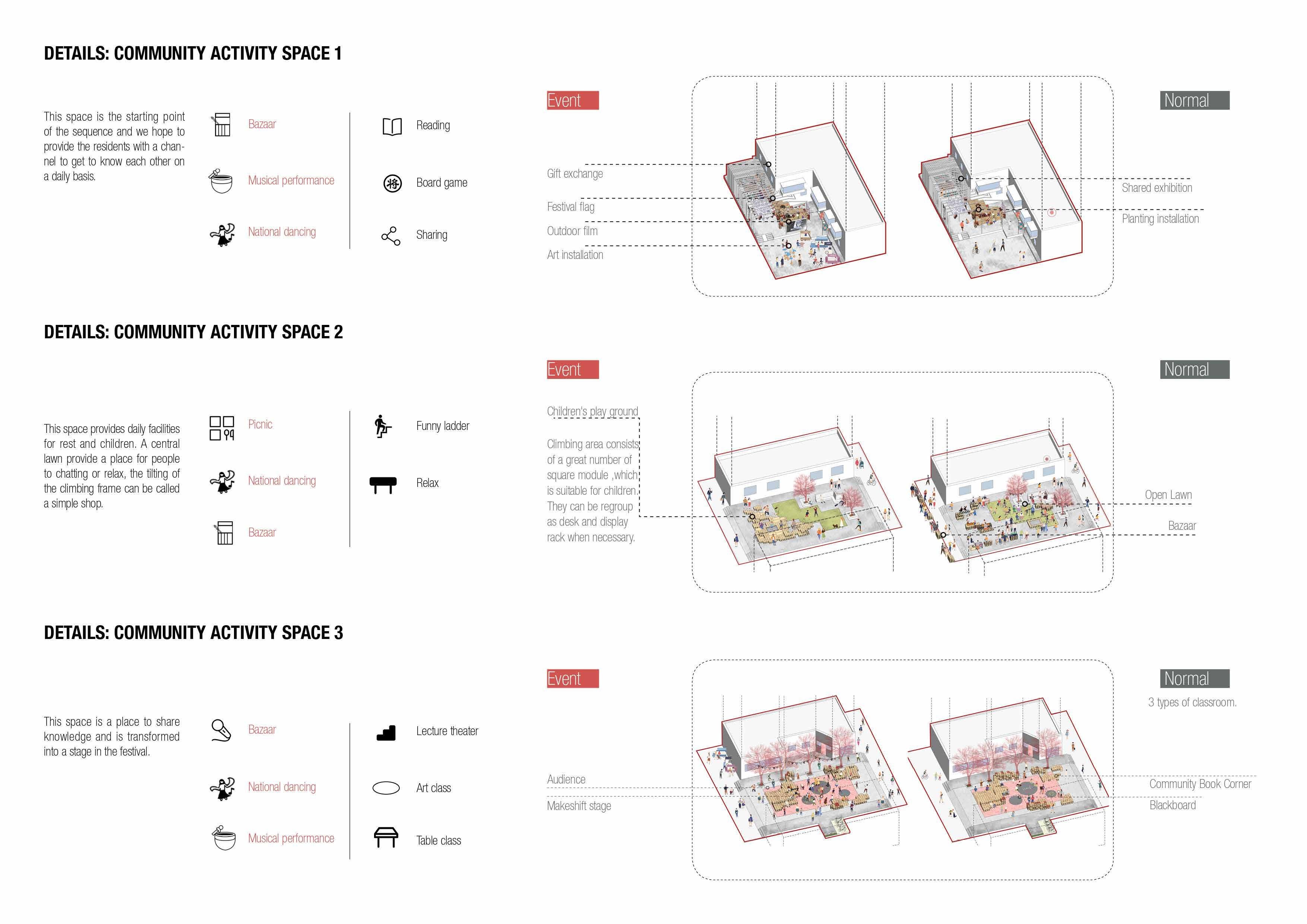
Wuxianguan-Huaisheng-Liuyi Temple is a Historical and Cultural Street located in Yuexiu District. It is a vital object of protection for the historical city. Since the Tang, Song, Ming and Qing Dynasties, the block had always been a religious place of imperial rituals. People had a strong collision between Chinese and Western from local Taoism, Buddhism, and Islam cultures. So it stimulated a fast-moving bond.
The area was once a popular commercial center. Therefore the question we asked was how to create a better co-habitat in the multi-ethnic community in this old neighborhood. Based on reality, reorganized the events and public space, at the same time, excavated the spirit of the local national spirits in the community. Based on a flexible, convenient space for residents to share and participate in the common intention of building a community together, the cube was selected as the basic module to establish a flexible combination model to create opportunities for residents, and bring positive change to the community. Above all, designed a part of public courtyard called CLASSROOM UNDER THE TREE.
Location: Guangzhou, China
Time: 2019.07-2019.09
Type: Studio, Group Work
Group mate: Ruoxi Zhang, Wanying Liang
Scale: 62700m
Instructor: Ankang Xu


EXTRAS - Model Collection
Terrain Vague - Into an imaginary war
#ScopethroughEnlightment 03

ROMAING IN AGES
- The Archeology Urban Wonderland.

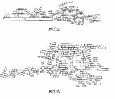
Rabbit Hill, an archaeological site excavated in 2003, located in Yiyang, China, comprises a large number of historical artefacts that reflect the beginning chapter in the city’s history. Like all developing cities in China, Yiyang is urbanising rapidly, homogenising both urban facades and culture. The discovery of Rabbit Hill seems to provide a chance to save the city’s history and cultural identity. The unknown heritage is remote from not only the surroundings and the whole city fabric, but also the local history.

Location: Yiyang, China
Time: 2020.10-2021.5
Type: MLA Studio, Individual Work

Instructor: Cannon Ivers & Alexandru Malaescu

Designed Notation
“Notational Systems in landscape architecture enable one to consider the simultaneity of different layers of experience, including movement and time.”(James Corner, 1991)


Interventions in landscape inhabitation would bring memories that buried in history back to people, to the modern times. Breaking the boundary means beyond the 3-dimentionals, it is more about the times that people could experience in history through juxtaposed ages.
As for the flat plan, rearranging the routes of the tour, connecting all the wells and pits.
In terms of 3-dimentional, below walkways stretch through the pits, of which up and down experience vertically according to the depth of each pit. The wells are exposed their layers and kept the original texture.
Regrading to the times, the 4-dimensional, the relics and antiques lie in their initial rooms, where protected by glass frames. Visitors watch through those artifacts and travel the pages of history…
Design process


The process diagrams shows the design development based on notation systems, and series of interventions enegaed. From the start ‘current status’, then recovering the original archeology features, removing the barrier(the wall), expanding it to the inside to be the deck and balcony for the whole community; reorganizing the routes according to archeology features, down to the ground, which creates vertical experience to find the heritage; dissembling the wells where exisiting antiques and relics, exposing their layers to visitors; as for protection, building up shelter(canopies) to avoid relics from bad weathers, the shape of them depend on the wind and sunlight; at last, in order to correspond the historic atmosphere, the plants could be part of creates historic environment, bending the trees, making them like ancient ones.


There are the marked relics and wells in pits, providing messages to the visitors about the chronological products. Opening aisles and arranging visiting routes create better exhibition routes for people who are likely to find the ancient stories.


The walking systems is divided into two: the above’ and ‘the below’ which allows tourists to choose their own routes. The above plank path is from the west entrance, crossing the underpass and finally reaching the east exit. The underground path is paved by sustainable and traditional material, pebbles with rammed soil, as well the retaining wall. The planting reserves the empty with grass, ornamenting some shrubs and small arbors, attracting birds to build their own habitat.


ARCHEOLOGY HALL
The Chinese Archeology Day is opening for tourists from all over the world. Local archeology institution holds a series of activities for popularizing archeology, which offers several imitative archeological pits and workbench for tourist to experience the whole process in archeology.
WINTER GARDEN


Proper time for pruning plants, the site is a winter garden for visitors to taste the various unique posture of those vagetation. At the same time, Seasonal use in Spring: Neighbors celebrate the Spring Festival in the site, they pray under the trees and relax or walk through.
The view from sunken way reflects the dynamic changing scene in people's motion and sight. The graph provides clues about visitor's position and the direction of view, as well as the events happened through a series of eyelevel views, including the antiques they may found. The mirror shelters(canopy) protects the relics in sunken space, refelcts sunken scene for people who walks on the surface and avoids them from bad weather.


 Vision of seasonal use in the Rabbit Hill.
PUBLIC PARK
Vision of seasonal use in the Rabbit Hill.
PUBLIC PARK
SECTION1- Envrionmental Sysytem SECTION1 - Envrionmental Sysytem
SECTION2 - Landscape Inhabitation


Material selection


General comment

For the protection of site itself and keeping originality the selection of materials should be aesthetic, sustainable, durable, local and natural. Pavement is able to soak the meteoric water, so as to the planting space. The facility(furniture), including the lights, benches, exhibition cabinet, canopy,etc. Besides, durability is for the time using, since the site would hold diverse events in the future.
Archeology Urban Park


The climate of the site is Subtropical Monsoon Climate, which represents the distinguishable season with abundant rainfall and active monsoon. Because of frequent rainstorm hazard, the site serves as reserve greenery for public recreation, furthermore, it has to possess the functions of rainwater collection and ecological governance.


The site is surrounded by buildings with diverse height, therefore the shade could be drawing in this emptiness like a painter during the day and years.


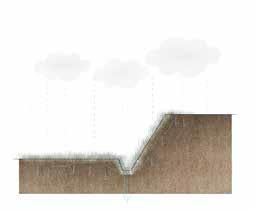
THE RABBIT HILL is an archaeological site, located in Yiyang, CHINA. It was discovered during real estate excavation in 2003. The contents of these slips and tablets with writing are mainly registry records, offering data for the study of local government operations 2000 years ago. Therefore it is the birthplace of the city, in order to protect, the wall had been built by the government, aiming to mark the heritage site in a conservative way. However, the clear border is actually separating the site from the city as well the history..
So, for saving the forgotten place, plan to blur the wall and time.
Beyond the edge, engaging each other, the site is a friendly neighbour.


Beyond the age, below the ground, the site is storyteller.
Isometric view


The pits are recovered from the under-earth and renewal reorganized their layout and accesses with natural materials. In order to aware people of the site's history, debris and antiques are originally preserved in their rooms. As for the surface walkway, it is lofted plank since the least damage of the grass land. Since artifacts are fragile and undetectable, mirror canopies could reflect them for viewers and protect them when facing rains.

SECTION2 - Landscape Inhabitation


Artifact Collection and Classification


Integrity
>80%
Construction component/ Weapon/ Cooker/ Clothes/ Vase/ Tiller


Structures

The first thing to arrage the route of tour is to set up the entrances of each spot according to its position and direction. The parts of them are reformed for better access and observation, whose materiality is mainly depend on original texture and local environment. Thus, for obey the environmental-friendly principle, the site will be realized by sustainable and durable materials based on itself.
Landform
Layout of pits


Construction component/ Currency/ Cooker/Clothes/ Vase/ Bamboo slips(ancient books)

Access
Construction component/ Pottery/ Cooker/ Weapon


50%-80% 30%-50% <30%
Can not be identified
Original vegetations


ARBOR

MATERIAL BOARD


Osmanthus fragrans (Thunb.) Lour. Phyllostachys arcana McClure Castanea seguinii Dode Ligustrum lucidum Ait. Albizia julibrissin Durazz.


Platanus occidentalis Linn.

Platycladus orientalis (Linn.) Franco Camellia japonica Linn. Rosa multifolora Thunb Festuca


Ophiopogon japonicus (Linn. f.) KerGawl.

Fatsia japonica (Thunb.) Decne. et Planch. Oxalis corymbosa DC.

Reineckia carnea(Andr.) Kunth Loropetalum chinense (R. Br.) Oliver var. rubrum Yieh


SECTION3 -Landscape Realisation
Since the protective measure had taken, the site had been backfilled three pits after archeology works finished and left only one who was covered by a pavillion, therefore its personalities and uniqueness are at a disadvantage. For fixing the DNA of the site, my intention is to recover all the pits that excavated during the archeological research period, hence return the artefacts back to their rooms and stories. The pits will become the resource space that exhibit the antiques, and also a area for Archaeology enthusiasts and researchers to further explore.


Recover the feature


SECTION3 -Landscape Realisation


For maintaining the sunken soil, the retaining wall is necessary to be permeable and drainage-friendly. Gabion wall is made of stacked stone-filled gabions tied together with wire, which could build an environment more natural by steping back with the slope, rather than stacked vertically.


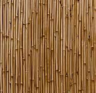
Since the city is well known for bamboo, local raw material can be able to replace with wooden plank and paving for walkways on the surface.


Besides, the gravel used consists of varing amount of crushed stone, sand and fines, which could be collected not only in the site itself but also in nearby constructions. Gravel pavement applies in sunken paths is beneficial the local rainfall permeation and filtration.


Central square is a gathering place in the whole tour, which contains exhibitions and facilities for people to visit and relax.

SECTION3 -Landscape Realisation
RAMMED SOIL


SECTION3 -Landscape Realisation PLANTING


Local
For reusing the archeology debris, the proposal is required to be constructible then easy to realize. The soil that was excavated to give ways for visitors below the ground accessibly is recycled and filtrated to build rammed earth walls, which are the best way to redecorate the open-air museum by inserting those relics.


earth Debris

Existingarbor
As for the planting strategy, preserving some of them originally, also steping in the techniques in slow-grown trees(tilted planted), which makes them more like the trees in ancient Chinese painting for building a historic environment for visitors. Besides, choosing some fast-grown tree for placing the shades in gathering case.
<Tinted planted tree>


Since the historic environment is more likely to create a realm that provides people back to the past, the reference is from local Chinese painting, 'Scholar viewing a waterfall', by Mayuan, late 12th–early 13th century. Tilted planting is new way of bending plants in the design by trunk's supprting. Combining with other shrubs for landscaping.

earth wall>

<Archeology pit >

<Dense tree>

<Rammed earth with gravel >


space>
The gathering space is shaded by specimen dense trees that growing fast for people gathering and relaxing. At the same time, the wells that reserved completely are protected by the trees.
SECTION3 -Landscape Realisation

DRAINAGE

The site has been damaged by heavy precipitation per decades, it is unable to carry the overload rainfall during the tests in section1, therefore, all the materials that used for pavement and structure are supposed to be permeable and sustainable to deal with the predicted disaster. Due to the existing slope, the landform can be regulated dranage-friendly, the same as the canopies, which protected the sunken relics.
#Scope through Professional
2019 Internship GWP Architects


Concept Plan and Deeping Design

Name: Guangzhou Fengsheng 101

Location: Guangzhou · China
Covering Area: 14000 SQM


Team Leader: Vivian Cai
Design Scopes: Master planning, Architectural design, Landscape design Awards: 2020 MUSE DESIGN AWARD: PLATINUM WINNER (UNITED STATES) 2020 ICONIC AWARDS: INNOVATIVE ARCHITECTURE-WINNER (GERMANY) 2020 WORLD DESIGN AWARD (GLOBAL) 2020 GLOBAL FUTURE DESIGN AWARD (GLOBAL) 2020 ASIA PROPERTY AWARD (ASIA) 2019-2020 ASIA-PACIFIC DESIGN COMPETITION-GOLDEN DIAMOND AWARD (CHINA) THE 5TH REARD GLOBAL DESIGN AWARD (CHINA) 2020 A&D AWARDS (HONGKONG,CHINA) 2020 IDA DESIGN AWARD (UNITED STATES) 2020 OUSTANDING PROPERTY AWARD LONDON (UK) 20212022 ASIA PACIFIC PROPERTY AWARDS (GLOBAL)


Main Task: Auto cad drawing; Rendering; Elevation and Plan drawing; Modelling; Diagrams;

The 50-year rainfall level is almost reaching at 230mm, which indicates the larger drainage demand. Hence preserving as much as possible greenery, and utilizing the advantaged landform and facilities to support better drainage and sustainability. The two types of wells, displayed and reserved, the former one are protected under the canopy, the left one are reuse for reaching the aquiderous layer to be drainable.

#Scope through Professional
2021 Internship - AURA Shanghai Studio
Deeping Plan
Name: Lingang Hi-tech Park


Location: Shanghai · China
Project Type: Office Campus

Team Leader: Eva Garcia Pascual; Natchanop Achintharangkoon
Architectural Design: Studio Libeskind (USA), Gensler (Shanghai), GALA (Shanghai)

Main Task: Auto cad drawing; Rendering; Elevation and Plan drawing; Modelling; Diagrams; InDesign Booklet
#Scope through Professional
2021 Internship - AURA Shanghai Studio


Deeping Plan
Name: Ningbo Ming Lake
Location: Ningbo · China
Project Type: Civic & Public Landscape


Team Leader: Eva Garcia Pascual; Natchanop Achintharangkoon
Architectural Design: RMJM
Main Task: Auto cad drawing; Rendering; Elevation and Plan drawing; Modelling;
PRE-PHASE ANALYSIS
Origin of Huai River
NorthJiangsu general canal
Hongze River
Regional Three Rivers
HISTORIC DEVELOPMENT
5000 B.C. 200 A.D. 1200-1300


Ancient shallow bay
As the climate warms, the oceans rises to form the shallow bay.
ECOSYSTEM PLANNING& DESIGN IN JIULONGKOU


Balance of the nature
Through the riverside wetland Through river net
Site: Wetland Network Sheyang River Sea


Freshwater lake
Lake water leakage, resulting in silting, which led to the formation of ancient sheyang lake.
The coastline moved east to donggang.
Ancient drain lake
Plain mire
The Yellow River captured the huai river, causing constant flooding.
Lake body silts and forms fresh water lake.
Bogs lake
2500 B.C. 1100-1200
900-1300
Vast water
1900-1950 1500-1800
Living with water
The water body moves to the southeast. The water level is decreasing. Agriculture developed rapidly.
Changing into land
Floods keep happening and the lake is silting up. Half of the lake was changed into plain land.
The original swamp was turned into farmland.
Reclaiming farmland


1800-1900
1950-1970 1970-2010 2019
Damaged wetland
Natural lake swing is developed into farmland fish ponds or settlements. Its total amount decreased repidly.


Losing self-resilience
Due to blind reclamation and precipitation changes and other factors easy to cause flood disaster.


Taking steps
Changes needs to be planned to ensure a sustainable ecology.


1300-1500
Large swamp
Silt from the Yangtze river has piled up here to surroud the land. The south water level is higher that the north, linking Jiangsu and Huaizhou.

Site: Jiulongkou Park +
Flood Depth


1m submerged area


2m submerged area


3m submerged area


Original dams
Weitian is the farmland reclaimed by levees along river, sea or lake. Dating back from its origin, farmers in ancient China invented the method of reconstructing low-lying land and contending with lakes for farmland.
is unique agricultural landscape in the hinterland of Lixia river. Historically, has been agricultural practice for flood control, population growth, and production.
