13 minute read
Understanding the existing
To critically comprehend the particularities present in the landscape of Brussels and therefore spot potentialities, an inventory of key infrastructures connected to the Leisure concept was established in the present chapter. As the focus of this research is oriented toward the notions of Leisure, Play and Water, some of those key infrastructures and networks were analysed.
[Leisure] When we talk about Brussels’ leisure spaces, parks and waterscapes are the first popping in mind. It is nowadays hard to say if those green and blue spaces where the product of nature or man-made endeavours. Nevertheless the status of those spaces, both are practiced daily by Brussels’ inhabitants. Luckily enough, the metropolis does feature a generous amount of parks and forests. On the plan of Water components, several key elements are emerging such as the Brussels-Charleroi Canal or the Senne/Zenne. These elements played an important role in shaping the city. The vaulting of the Senne/Zenne was one of the most prominent and reknowned works.
Advertisement
[Play] Linked to parks and forests territories, playgrounds and outdoor sport facilities are most the second most used recreative components. Those are usually placed around open-landscape situations, mostly around or inside parks. It is hard to map all of them as their small size and communal management keep them from being localised on the extensive territory.
The concomitant spatial distribution of playground and sport facility is interesting to notice, as if playground for kids demand facilities for grown-up nearby. The size of both elements can vary a lot, but even the slightest Play / Sport infrastructure has an impact on how leisure is practiced in urban areas. Some playgrounds are in poor states due to their age and lack of maintenance but the general distribution is pretty correct.
[Water] As about the water infrastructure -if we exclude the major water sources like ponds, rivers and canals - smaller elements such as sources, fountains and swimming pools do play an important role for the city. They don’t always connect directly to leisure spaces but do provide interactions with other components which play a major role. Sources for example, are irrigating bigger water infrastructures. They are the most neglected water feature nowadays. Their position and streams were forgotten with time and few of them are still buried. To supplement sources, the modern fountains were placed to embellish mostly urban historical centres. Some of them do play a role in leisure activities during summer like the St. Catherine/St. Katelijn Basin. Swimming pools on their part are known and used for leisure activities. Even if the primary role was to teach how to swim and develop sportive swimming the direction taken by modern pools tend to orientate furthermore into leisure practices of water.
[Heat]To finalise our understanding about Leisure in the city, the way climate induce certain activities needs to be taken into account. For this reason, the heat distribution during summer months will be examined to try to propose a complimentary response to temper the impact of such heatwaves and the activity they prevent.
NATURAL SPACES
Brussels features a magnitude of different leisure and natural spaces. Those are usually immense in size but smaller version of natural spaces do exist.
It is a hard task to determine what is considered as natural or man-made element of a landscape. For this reason the term natural will be defined as a permanent and landscaping component of the territory. A place which allow connection to natural elements such as trees, grass, water, wind. It is indeed the recreational aspect of those natural spaces which arise our interest.
[Parks]A wide networks of parks, some inherited by colonial past, is present in Brussels. Those green space usually nicely connected, do provide fresh air and calmness the busy city.
[Private Parks]The biggest parc of Brussels is a private park, the Royal Domain of Laeken. It is the place surrounding the Royal family palace and is therefore inaccessible.
[Forests]The Sonian forest and the connected La Cambre forest is a primordial element in the regional landscape. Having a forest in the regional boundaries of a metropolitan city is indeed a lot of luck. This forest, is complemented by other smaller forest also situated in the periphery.
[Rivers and Canals] Few rivers flow in the region, the Zenne/ Senne is reminiscent is some areas of the city, most of its trail was vault due to hygiene problems, Maelbeek, Molenbeek and other small watercourses are also present but mostly hidden on the territory.
The Canal is the major element and its surrounding waterscape is currently being transformed due to the city impulse. The Chemetoff Kanal Plan Canal, started in 2012 and is leading to major beautification and gentrification projects.
[Lakes and Ponds] Other water elements sometime connected to sources like lakes and ponds are shaping the city. The most reknowned are the Ixelles/Elsene ponds, Josaphat ponds, La Cambre ponds and Mellaert ponds
[Hofstade]An important element of the landscape, imagined in the 70’s is the Hofstade lake and beach. The location , tariffs, and accessibility problems lead it to fall into disuse.
In the pentagon fewer of all these elements are featured. Most of the quoted natural components are present in the periphery.

SOURCES
Since ancient times, sources have been precious resources, providing free drinkable water. Since the last century, and the establishment of the water irrigation and sanitation system, the primordial interest for sources was lost. This lead to a common forgetfulness of their historical presence and social gathering connections they allowed. This water interaction was crucial in the ancient time as it permit social exchanges as we could nowadays envision on social media.
If we look closely at the distribution of sources most of them are situated in the urban periphery of the metropolis. The current count is set to 62 sources in the regional border of Brussels. This number could vary in a near future as we are rediscovering some new ones lately.
The actual absence of those natural sources in the pentagon arises a real concern. Is it the concretisation of the city centre which doesn’t allow to spot them anymore ?
The modest streams and location won’t allow any real use of these sources nowadays but their historical presence should be remembered
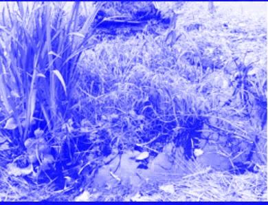
Fig. 37 - Ganzenweidenbeek (5) Fig. 38 - Royal Domain (10) Fig. 39 - Marly Source (8)
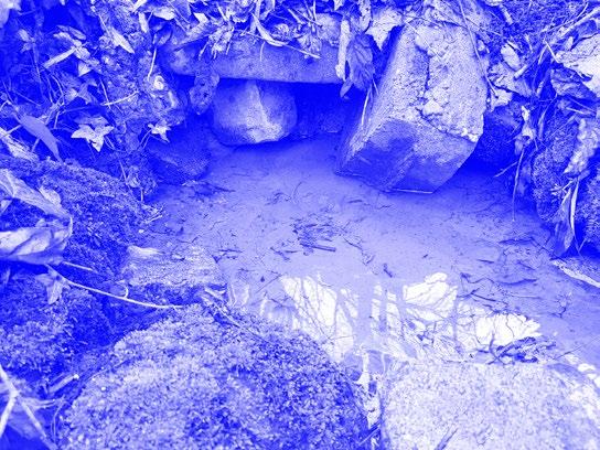

Fig. 40 - St. Helène (28) Fig. 41 - St.-Josse Church (23) Fig. 42 - De Fré Av. S. (58)


Sources
1.Source of Saint-Landry 2. S. of Keelbeek
3. S. of Tweebeek #1
4.S. of Tweenbeek #2
5.S. of Ganzenweidenbeek
6.S. of Hembeek
7.S. of Meudon street
8.S. of Marly 9.S. of Meudon Park
10.S. of Royal Domain (private) 11.S. of Laerbeek
12.S. of Keelbeek
13.S. of Puits Léon XIII
14.S. of Kerkebeek
15.S. of Poelbeek
16.S. of Doolegt Park 17.S. of Mulder Park 19.S. of Paruckbeek #1
20.S. of Paruckbeek #2
21.S. of Paruckbeek #3
22.S. of Hof Ter Musschen
23.S. of St.-Josse Church 24.S. of Stuybeck 25.S. of Malou Park
26.S. of Woluwe
27.S. of Parc des Sources
28.S. of Felix Hops 29.S. of Paulus Park
30.S of Neerpede street #1 31.S. of Scheldermaal street
32.S. of Mellaerts Ponds
33.S. of Rietveld van Neerpede 34.S. of Neerpede street #2 35.S. Saint-Helène 36.S. of Peters’ College (private) 37.S. of Maelbeek
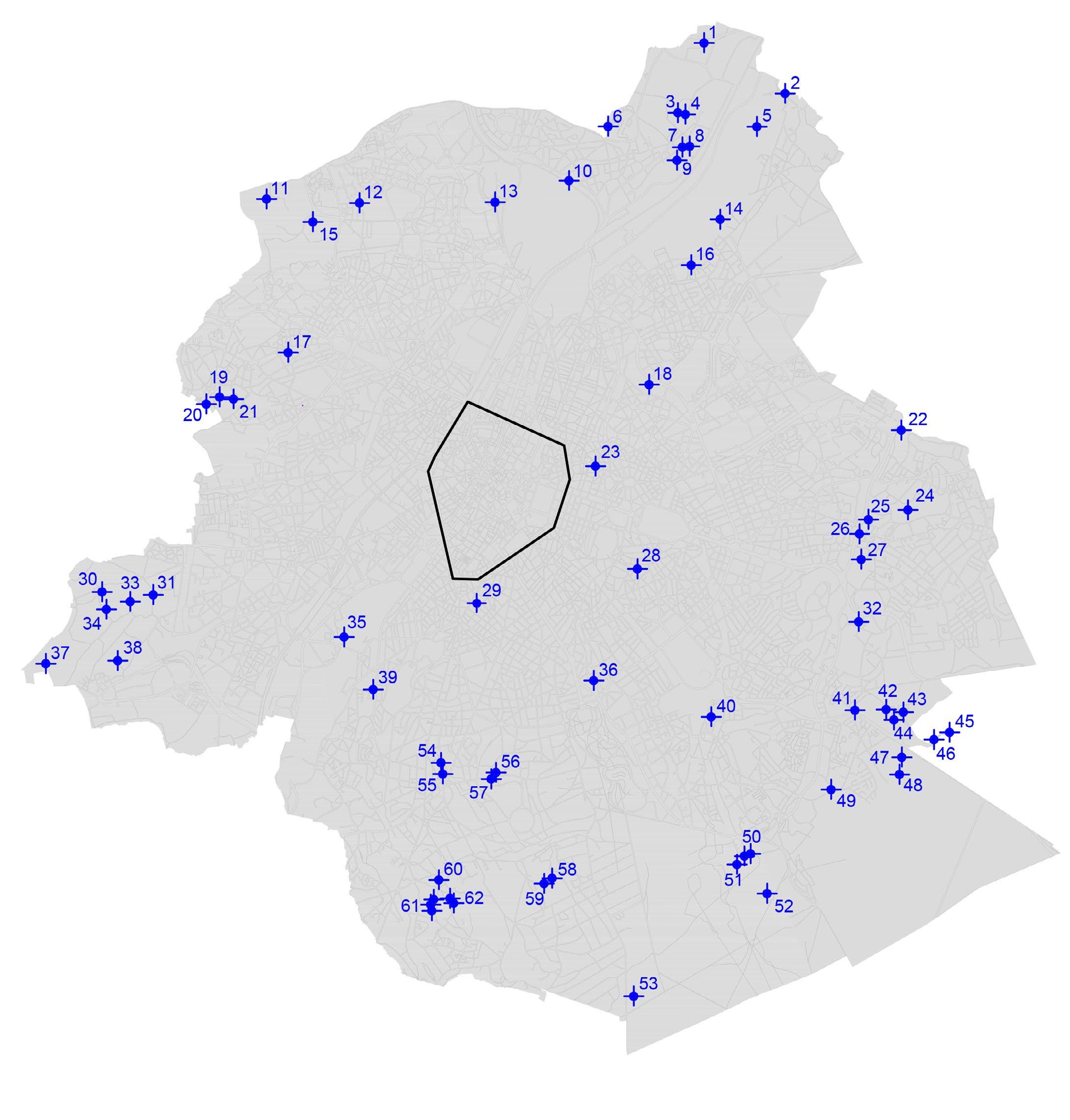
38.S. of Koevijver 39.S. of Langewei 40.S. of Calvaire /Golgotha 41.S. of Ter Coigne Park 42.S. of Jean Mussart Garden 43.S. of Basse-court / Neerhof 45.S. Rood Klooster
46.S. du Sylvain / Bosgees 47.S. l’Empereur / Keizerbron 48.S. of 3 Fountains
49.S. of Roodkloosterbeek
50.S of AXA Domain
51.S of Royal Domain 52.S. des Enfants Noyés 53.S. of Vuylbeek 54.S. of Linkebeek
55.S. of Peters’ College (private) 56.S. of Peters’ College (private) 57.Russian Embassy (private) 58.S. of De Fré Avenue
59.S. of Roosendael
60.S. of Fond’ Roy 61.S. of PappenKasteel (private) 62.S. of Groelsbeek
FOUNTAINS
Build for embellishment purposes, fountains have a significant presence in urban settings as well as in our collective psyche. Every inhabitant could describe or define the nearest fountain they know. They exist in different colours, size and shapes.
A common distinction is accepted to separate the notion of fountain to the notion of basin. Both of them are manmade water interaction constructions but the word basin describes more precisely a bigger horizontal fountain while the word fountain generally depicts a more vertical and narrow construction.
If we look at their distribution on the territory, the pattern indicates a greater presence in the centre of the city. Indeed, those human endeavours were used to decorate public spaces which are mostly situated in the historical centre of Brussels. From the 15th century some fountains did also play a role, a bit like sources, to provide water to its inhabitants.
The new typology of water mirrors creates new way of interacting of urban water play. Those novel elements need to inspire new projects especially those coping with summer heat waves.
Fig. 43 - St. Catherine Fountain (20) Fig. 44 - De Meux Sq. F. (35) Fig. 45 - Flagey Fountain (43)
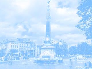

Fig. 46 - Calder Fountain (28) Fig. 47 - Park of Brussels F. (24) Fig. 48 - Stephania Basin (55)


Fountains
1 . Centenaire Basin
2. Osseghem Park Fountain 3. J. Palfyn F. 4. Centenaire Boulevard F.
5. E. Bockstael F.
6. Laeken Park F.
7. Sq. Prince Leopold F. 8. King Boudewijn Park B. 9. E. Bockstael B.
10. Poelbos B.
11. Miroir Sq F. 12. Laerbeek Forest F.
13. Elia B.
14. M. Thiry F.
15. Patria Sq. F. 16. Dailly Sq. F. 17. A. Steurs Sq. F. 18. Botanical Garden F. 19. Botanic F. and B.
20. St Kathelijn F. 21. De Brouckère F.
22. St Kath. B.
23. Pacheco F.
24. Park of Brussels F.
25. Beurs Water Mirror
26. St Gery B. 27. Park of Brussels B.
28. Calder F.
29. ING B.
30. Conservatory F. 31. Little Sablon Garden F.
32. Merode St. F.
33. Ambiorix Sq. B.
34. ERM F.
35. J De Meux Sq. F. 36. G. Henri Park F. 38. 2 Tomberg B. 39. Clos du Cinq B. 40. Cinquentenaire Park F.
41. Montgomery F. 42. Leopoldville Sq. F. 43. Flagey F. 44. Albert II Park F.
45. VUB F. 47. Valduchesse F. (private) 48. Pêcherie F.

49. Héronnière Park F.
50. Tournay Solvay Park F. #1 51. Tournay Solvay Park F. #2
52. Van Der Elst Sq. B. 53. Forest Abbaye B.
54. South Water treatment Facility
SWIMMING POOLS
Focusing on swimming pools, this firstly educational and sportive tool, is maybe the most common weekend activity. Indeed the networks of pools is wide and pretty well distributed. If we take the regional borders of Brussels, 18 public indoor pools are present. As a reflexion, the maps also show the pools from surrounding communes. In red, the private owned pools compliment this networks of communal public pools. Those are sometime accessible to public even if not directly subsidized.
Some major problems arise from those water infrastructures. The maintaining costs and sometime old age of pools creates lots of financial problems for their owners. All of them are financed and managed by their communes and usually a huge burden for their expenses. Communal pools appeared in the 60’s as a political argument. This is why the distribution is not well-thought as the only objective was to place it within the communal borders.
Tariffs are usually cheap but sometimes prohibiting access for poorer population. A variation in price is conducted privileging inhabitants of the commune.
Pool rules also prohibit to enjoy freely play and leisure as it is prohibits to play with a ball or eat or wear burkinis.
Fig. 49 - Bain de St-Josse (7) Fig. 50 - Neptunium (5) Fig. 51 - Stadium Kinetix (24)


Fig. 52 - Bains de Bruxelles (13) Fig. 53 - Nereus (3) Fig. 54 - Villa Empain (30)

In Brussels
1.Neder-Over-Hembeek
2.Omnisport La(e)ken
3.Nereus
4.Louis Namèche
5.(Neptunium) - CLOSED 6.Tritton
7.Bain de St-Josse 8.ERM / KMS
9.Poseidon
10.Espadon
11.VUB
12.(Ixelles) - CLOSED 13.Bains de Bruxelles
14.Victoir Boin
15.Ceria / Coovi
16.Longchamp 17.Callipso 2000 18.Sportcity
Out of Brussels
19.Pierebad (Strombeek) 20.Dilkom (Dilbeek) 21.Wauterbos (Rhode st Gen)
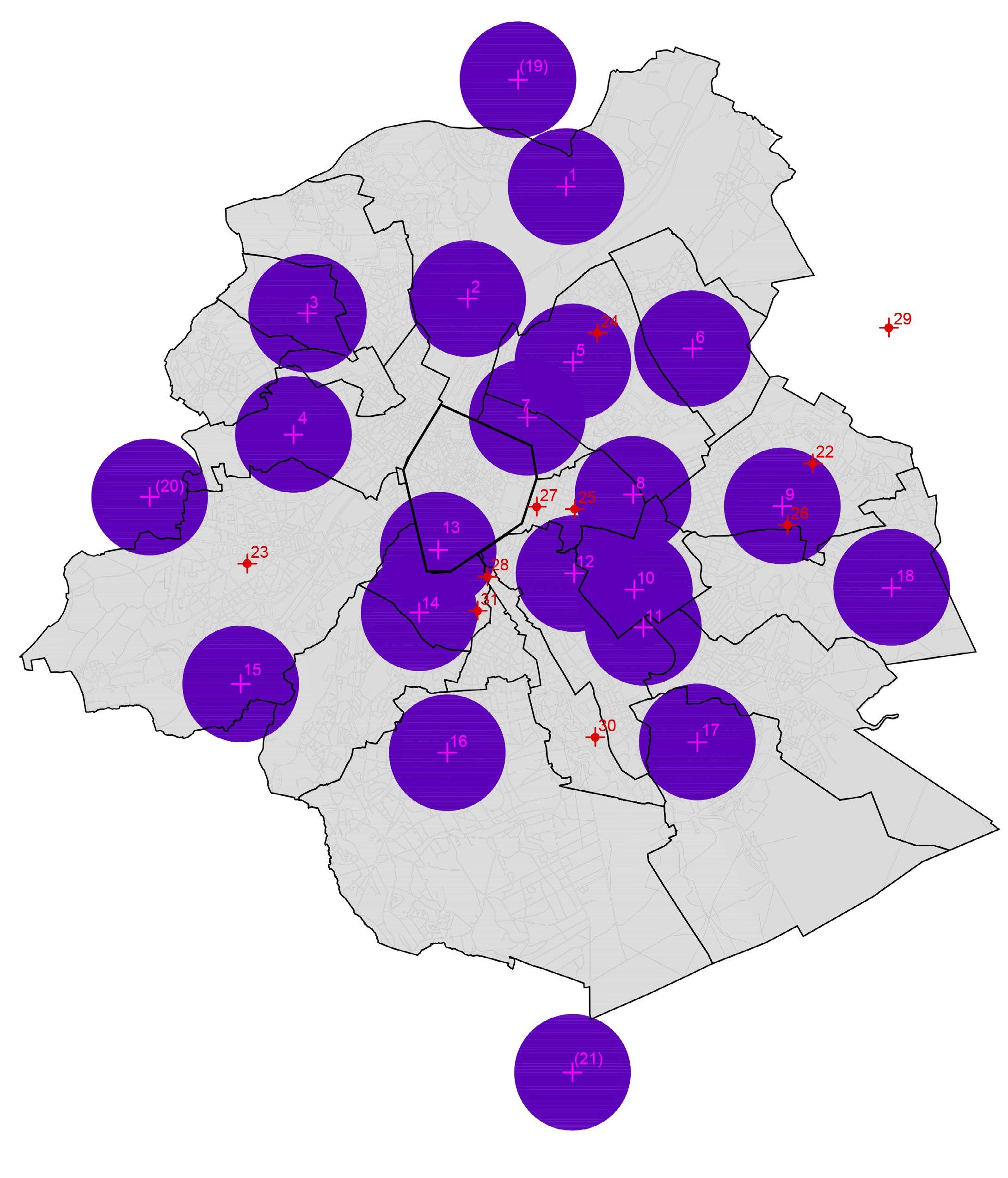
Private Pools
22.Athénée Royal 23.Stadium
24. Stadium Kinetix
25.Résidence Palace
26.Aspria La Rasante 27.Aspria Art-Loi 28.Aspria Louisa 29.Castle Club
30.Villa Empain 31.Jam Hotel
PLAYGROUNDS / OUTDOOR SPORTS
Known by most of the youngest inhabitants, playgrounds are essential transitional and leisure urban spaces. Their size and formal conception features extremely wide variations.
The implementation of outdoor sport facilities is more recent and less recognised. Those slightly new infrastructures are still pretty much intensively used. The beauty canons and the well-being benefits sport induces do play a role in these behaviours.
The combination of those two recreative elements is also pretty new on the territory and allows a more diverse reach of public usages.
All these recreative components are featured evenly in the region except for the more dense historical centre which doesn’t allow play as much.
The notion of play induced by those playgrounds and sport utensils, does not correspond generally to the definition of Van Eyck’s play spaces. Too much accent is given to the plastic representative shapes, not allowing children imaginative processes. The fact those utensils and play tools only allow one-only way of playing also reinforce this lack of transformative play influenced by the modern playground designs. Luckily not all playground and outdoor sport facility fall into this deviant contemporaneity.
Fig. 55 - Rouge-Cloître (Playground) Fig. 56 - G. Henri (Playground) Fig. 57 - Pirsoul Park (Playground)
Fig. 58 - Mudler Park (Play + Sport) Fig. 59 - St. Pierre Street (Sport) Fig. 60 - Maximiliaan Park (Sport)


HEAT ISLANDS
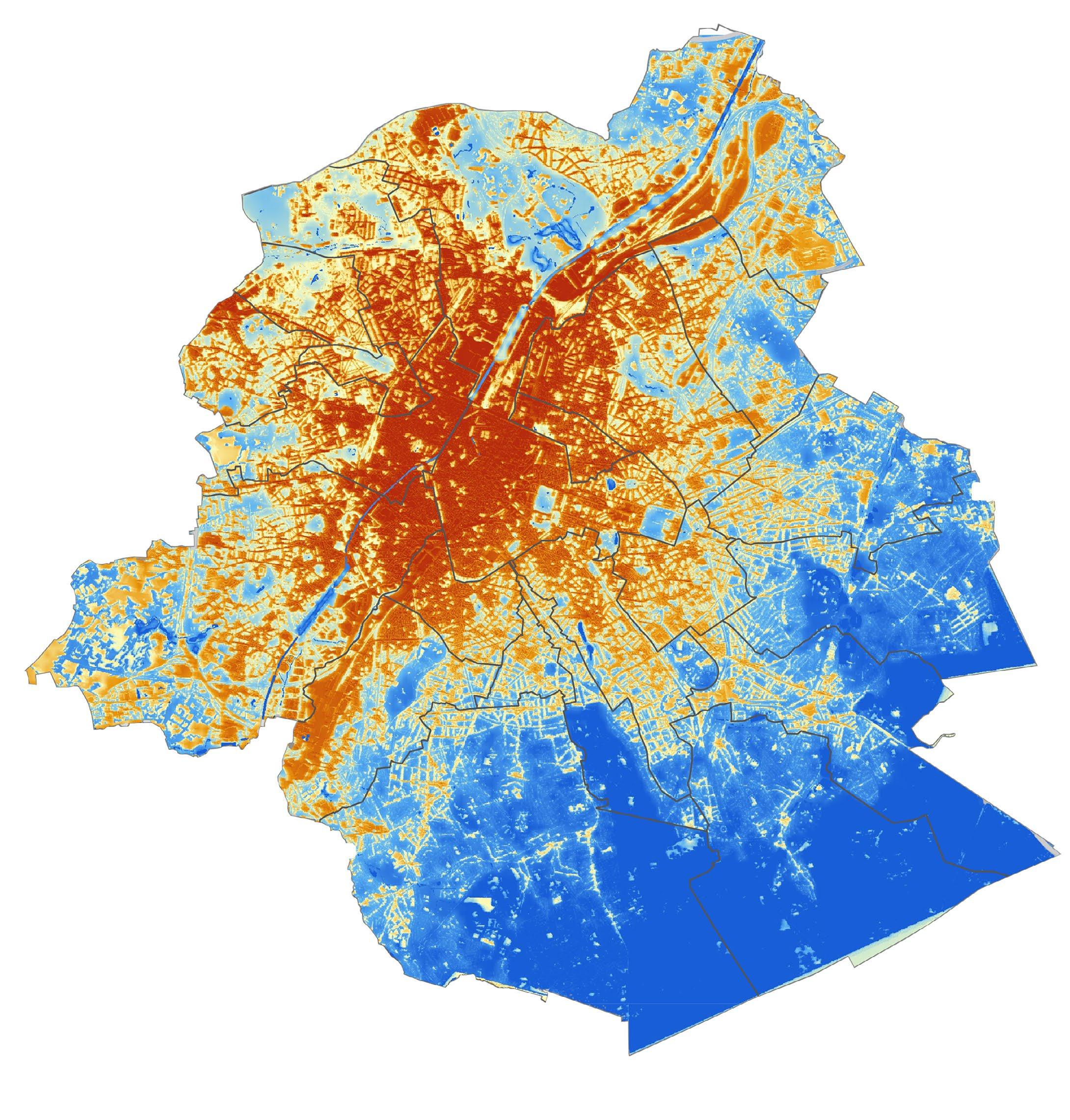
The last element to understand fully the territory of the metropolis is linked to climate. During summer days, some urban locations are experiencing vivid overheating. Those spaces can face a difference of around 3 to 4 degrees higher than the average temperature of the city. This phenomenon is caused by multiple factors such as the albedo effect or concretization of spaces. Human activity and material inertia creates even more heat and adds-on to those effects.
On the contrary parks and water infrastructures are enjoying a milder climate. Perspiration of vegetation and water evaporation help cooling.
The two present maps realised by VITO and UrbClim help us comprehend the distribution of those heat islands.
In general, the inner dense city areas are conveying more heat (in red) while suburbs and parks (in blue ) are usually colder.
The potential and inertia of water elements used to cool is of real interest, this process is known since roman times.
On the figure below, a zoom of the heat map was overlayed with the other infrastructures previously studied. We can clearly see there is a potential to address in the pentagon (chosen site).
Fig. 61 - Heat Islands Map of the pentagon (From a base map of VITO & UrbClim)
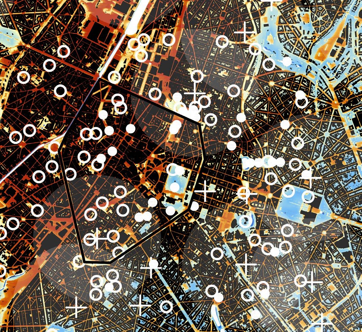
Fig. 62 - Heat Islands Map of the Region (Source: VITO & UrbClim)
