THE COST OF BUSINESS AS USUAL
zones “If you always do what you’ve always done, you always get what you’ve always gotten.” - Jessie Potter at 1981 National Women’s Conference
6, 7,8
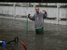
3’ WATER IN RESIDENTIAL BASEMENTS + BACKYARDS
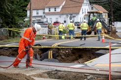
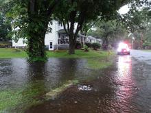
2 SINKHOLE AT MBTA COMMUTER RAIL WATER RUSHING DOWN STREETS
“RIVER” RUNNING DOWN STREET
4 SINKHOLE FLOODED PARKING LOTS SIDEWALK COLLAPSE BRIDGE WASHED OUT + RESIDENTS STRANDED

10 STREET FLOODING + BUILDING COLLAPSE
9 ROADS + DRIVEWAYS CRUMBLE

LAND
NORTHEAST LEOMINSTER - PRIORITY AREA 1 OF 2


BURRAGE/MASCOMA FLOOD SITES
+ WATER SYSTEMS ANALYSIS
LOST STREAM A
MBTA SINKHOLE
N 0.0 0.25 0.5 miles
LOST STREAM B
LOST STREAMS + FLOOD DAMAGE CORRELATION
FEMA flood predictions
Hydric soils
Unranked soils
Impermeable surfaces
Historic location of Nashua River ~ 1830
Lost streams, “A” and “B”
Suggested paths to daylight lost streams
Flood sites referenced in report
Point selected for drainage delineation
Drainage basin to point, 0.59 square miles
Longest drainage path in identifed basin
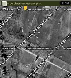

1938

agricultural plots, no road
1963
dirt road appears
1968
paved road appears
We chose a point, , just south of the 2023 MBTA sinkhole site and delinated a drainage basin to that point. The catchment area that drains to this point covers 0.59 square miles, of which 4.11% is forest and 3.46% is wetland or water body.1
The longest drainage path in this sub-watershed meanders around the same route as lost stream A that we found on historic topographic maps. Government maps from 1830 onward2 indicate the following:
Stream A is on all maps through 1979.
Stream A is not on the 1988 map or any maps thereafter.
Stream B is on all maps through 19XX. Stream B is not on the 19XX map or any maps thereafter.
Since topography remained the same after these streams were lost to development, water naturally continues to channel down the same pathways.
SOIL AND LAND USE
Hydric soil forms when soil has been saturated by water, seasonally or year-round, for long periods of time. It is characteristic of wetland habitats.
Unranked soil has been significantly altered by development, so soil type is difficult to determine. It is possible that these areas are also hydric, but a boring sample would be required.
In addition to the lost streams, the area surrounding the sites with severe flood damage is further compromised by inappropriate land use on hydric soils. The area’s ability to capture and store water is is severely inhibited due to:
• impermeable surfaces like roads, driveways, and parking lots that cover hydric soils
• non-native turf-grass lawns that cannot hold much water
• interrupted and/or redirected drainage routes
Since residents at 75 and 76 Burrage Avenue experienced 3+ feet of water in their backyards and basements, we investigated the intersection of Burrage Avenue and Mascoma Avenue. Historic findings3 (pictured at left) indicate that Mascoma Avenue did not exist until the 1960s. This road is along a critical drainage pathway, so the area will continue to experience flood damage if there is no intervention. 1
info from USGS NLDC 2006 data set and StreamStats run on 3/16/23 2 topographic maps found in public records are from goverment sources 3 aerial images from Nationwide Environment Title Research, LLC database
REVIVE LOST STREAMS
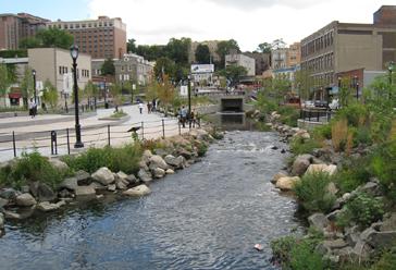
Prevent property damage and safety hazards by restoring critical lost streams. Nature will follow the path of least resistance regardless. The path we suggest follows the topography that dictates water drainage routes, while minimizing impact on homes as much as possible.
RESTORE WETLAND AND CREATE BIOSWALES
Through strategically restoring some of these hydric soils to their native wetland state --such as those in the country club, open space, and flood plains -- water storage would increase significantly. This is a long-term, low-maintenance, flood risk mitigation strategy that will continue to function with nature over time, as opposed to grey infrastructure that goes against the watershed dynamics.
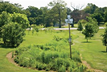
In residential areas with hydric soil, we advise vegetated bioswales to capture and store water. Like the wetlands, these stormwater catchment basins will store and slow water much better than the non-native turf-grass lawns currently in these areas. Native plantings will provide aesthetic benefits and environmental improvement across all seasons, while simultaneously reducing time and finances currently spent on lawn care.
REVISE UNDERUSED IMPERMEABLE SURFACES
Tas esciaer natiunto evelias sam qui nobitiatus esequam secabo. Nam istia prempores mi, ellaut aut aut omniscide nonsedicid quid maximpore net aut volorup tatecum estrum sum, nonsectatem etur sam et occum quis at ut lam, coriam, unt as mosseni il experup tatur?
Corit pre ea voluptatiur ma que pratemp orrovidunt. Iqui ne officte molorep udissimus rae officias il in rehendamus et quiaesecto eos simagna temquas pereper
COST AND MAINTENANCE
Ipidis rerumque ne alit volectoreped ut incidundit mo dolendis sunt resed ma doluptat et excestion re most, si doluptatur? Idia dolum re es aut labor maion rese pra si dolupiet mi, si quatur aute volorum, occuptatur auta volorro repelectem inctotature apelluptati aris molorrorest, si totatiam volori rem dendae rehenti issimus et fuga. Elest aspidus aditias ullenim re volorpor sequam, quoditio est

Suggested wetland + planted bioswale area
Suggested stream daylighting paths
Lost streams
Hydric soils
Unrated soils
Drainage point for basin delineation
Border or drainage basin to point
Sites with severe flood damage
DRAFT FLOOD RISK MITIGATION STRATEGY: NORTHEAST LEOMINSTER, CONTINUED
Example of urban stream daylighting with Saw Mill River in Yonkers, NY
Example of residential vegetated bioswale to catch, store, filter, and slow water

