MGS County Mapping Program
Introducing New Staff
Free Geologic Maps


Geologic Points of Interest YouTube Series
Outreach and Education Activities
Triage Project Update
Accessibility Mapping
Core Stories and Outcrop Stories

In Memory of Lloyd Schmaltz
Highlights >>>
A Note from the Director
The Michigan Geological Survey has been funded for six months and MGS has hired four full-time and one part-time staff and recognized three Western Michigan University staff as part of the MGS organization for a total of eight MGS staff. These hires and WMU consolidations can provide the growth for MGS to meet the initial societal needs for Michigan. These include research and data components on water resources, hazards, aggregates, climate change, energy, carbon storage, hydrogen storage or generation to name a few. All immediate societal needs for Michigan. We are also training the next generation of geoscientists to help Michigan and the US to better understand why geology is important to understand any natural resource. We thank you for your support and funding.
John Yellich
For more information go to
https://wmich.edu/geologysurvey


https://wmich.edu/michigangeologicalrepository
Core Quarterly
MGS County Program Meeting Societal Needs through Natural Resource Mapping
Michigan has mapping priorities from the Michigan Departments of Environment Great Lakes and Energy (EGLE), Natural Resources (DNR) Agriculture and Rural Development (MDARD) and public comments from meetings. These have provided the initial direction for mapping in up to 25 counties having water resource areas and geographic locations having PFAS impacts to groundwater including the location for aggregate resources near the surface. Mapping and data analysis is to better understand water resources, hazards, aggregates, climate change, energy, carbon storage, hydrogen storage or generation. MGS has applied for and received US Geological Survey mapping funds to provide Federal funds which require State Non-Federal funds as a 1:1 match to support these surficial geologic efforts. The current funding will support production of mapping products such as a surficial geologic map for Allegan and Muskegon Counties having derivative mapping products showing thickness of aquifers in the drift or where there are bedrock aquifers. MGS will also do a consolidation of Kalamazoo County from historical mapping products and Cass County into a consolidated map product. These map products will include a summary report describing the locations of known or potential aggregate resources as well as surface areas that are potential groundwater recharge areas. Surface soils for agriculture or other resources, wetlands for near surface water, bedrock topography with depths, groundwater water level maps of the area and 3D geologic cross sections through many of the areas will help to better understand the subsurface geology for managing water, aggregates and anthropogenic impacts. MGS is also submitting proposals to map subsurface cores, samples, and data preserved at the Michigan Geological Repository for Research and Education (MGRRE) for use in climate change, energy, carbon sequestration and hydrogen storage research. All new samples and cores acquired through drilling and mapping will be archived at MGRRE. Data from those materials wil be incorporated in MGRRE on-line databases for easy access.
Issue 2 Spring ‘23 in this issue >>>
Quarterly Updates from the Michigan Geological Survey
Introducing New Staff
Ashley Quigley – MGS Precambrian Geologist

Ashley is a Precambrian geologist with a strong background in the geology of the Great Lakes Region. She has worked as an exploration geologist in Michigan, Wisconsin and Minnesota for 10 years focusing on metallic deposits hosted by the Proterozoic rocks of the Penokean volcanic belt and Midcontinent Rift. Most recently, she worked in the Carolina Slate Belt of North and South Carolina using historic data and new geochemistry, SWIR and geologic observations to update the understanding of the geology and metallogeny of the Carolina Terrane. She earned her M.S. in economic geology from Colorado School of Mines and B.A. in geological sciences from the University of Minnesota – Duluth. Ashley will be focused on the Precambrian geology of the Upper Peninsula of Michigan supporting the assessment of the natural resources of the region.
MGRRE Partnership with Midwest Regional Carbon Initiative

MGRRE has been a key partner on CCUS research projects for nearly 20 years! We continue research and collaboration with the Midwest Regional Carbon Initiative (MRCI) which is co-led by Battelle and the Illinois State Geological Survey. MRCI began in 2019 and goes until 2024. MGRRE provides geologic expertise and critical data and information. To date, we have provided numerous geologic maps, information on thousands of wells, and key reservoir properties. To learn more, visit:
https://www.midwestccus.org/
Robert Mahin – Contract Geologist
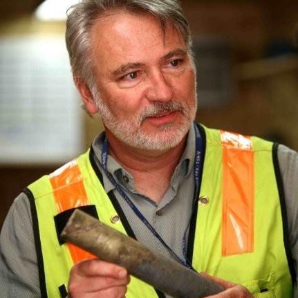
Robert (Bob) has nearly 30 years’ experience in the exploration field, including upper management roles in the battery mineral space - primarily nickel. His project experience ranges from grassroots to brownfield exploration. Bob has led and fostered multiple teams and consulted on a variety of mineral projects in Michigan, Sweden, Norway, and Botswana. Bob earned his M.S. in Geology from the University of Utah and his B.S. and B.A. in geology and technical communications from Purdue University. Bob will be focused on the Precambrian
Follow Along with Our Geologic Points of Interest YouTube Series
Discovering Michigan's Natural Treasures." This captivating video series takes you on a virtual journey through the breathtaking landscapes and fascinating geology of our beloved state. We uncover the hidden gems and geological wonders scattered throughout Michigan. From ancient rock formations to stunning waterfalls, our team has curated a collection of episodes that will leave you in awe of the natural beauty that surrounds us.
To get started, simply visit our YouTube playlist by clicking on the following link: https://youtu.be/75QB3OFbEi0. There, you will find the episodes we have produced thus far, each one offering a unique insight into Michigan's geological heritage. We encourage you to subscribe to our channel to stay updated on future releases as we continue to unveil more exciting locations.
Our team has been hard at work developing an interactive ESRI StoryMap, which will showcase even more geologic points of interest across the state. This immersive experience will allow you to explore these locations in greater detail, providing an enriching educational resource for all


geology enthusiasts. Keep an eye on our website for the upcoming release of the interactive ESRI StoryMap upon conclusion of the video series, as we believe it will further enhance your exploration of Michigan's geological marvels. We will notify you once it's available, so you can dive deeper into the diverse landscapes and geologic history that define our great state.

Key Updates >>>
Outreach and Education Activities
Autumn Haagsma Co-Chairs National CCUS Conference in Houston – “Both the subsurface technical knowledge and related data sets developed by the petroleum industry are major inputs required for the world to successfully move towards a carbon-neutral and sustainable energy future”
Autumn Haagsma, MGRRE’s Director, co-chaired a national Carbon Capture, Utilization and Storage (CCUS) conference in Houston. More than 1400 participants met to share ideas about climate change, carbon storage, and moving the world toward a carbon-neutral and sustainable energy future.

Autumn helped create a CCUS committee and launch the first American Association of Petroleum Geologists (AAPG) supported CCUS conference in 2021. Since that time, the CCUS conference has tripled in size, gained support from multiple leading organizations including the Society of Exploration Geophysicists (SEG) and Society of Petroleum Engineers (SPE). CCUS 2023 has gathered leading technical experts to demonstrate the ongoing need for petroleum geoscientists and engineers in the CCUS arena.
The conference included 130 oral presentations and 54 poster presentations. More details about the conference can be found at https://ccusevent.org/
Additionally, Autumn was interviewed by Elena Melchert as part of her Oil and Gas Upstream podcast. The episode will be available this summer. https://oggn.com/podcasts/oil-gas-upstream/

K-12 Outreach reaches more than 350 Students this Spring!

The outreach team has been busy engaging with hundreds of students, educators, parents, and general public between April and June. Events included elementary school visits, earth day booth, rock show booths, and tours.
MGS/MGRRE Shines at GSA North-Central Section Meeting
At the GSA North-Central Section Meeting, May 4 5th in Grand Rapids. MGS/MGRRE staff made presentations, co-led two field trips, and held a


Our annual PTTC workshop is planned for November 2nd and titled “Revisiting Michigan’s Carbonate Reservoirs”. This will be a core workshop hosted at MGRRE with a series of excellent technical presentations.


Friends of the Pleistocene Meeting Provides Important Geologic Insights
May 19-21st MGS/MGRRE staff participated in the FOP field conference with 90 others, focused on glacial and geomorphic evolution of the Houghton Lake Basin
 Autumn Haagsma delivering opening remarks
us for PTTC in
Autumn Haagsma being interviewed for a prestigious podcast at the CCUS conference
Join
November
2022 PTTC workshop participants
2023
Scientists at the
FOP Field Conference
Outreach and Education Activities
CoreKids – A New Logo to Reflect its Mission!
 By: Peter Voice and Marie Solum
CoreKids has been running since 2007 when Sue Grammer started the program. Initially the outreach program for the Michigan Basin Geological Repository for Research and Education (MGRRE), now the program is the K12 outreach program for the WMU Department of Geological and Environmental Sciences, MGRRE, and the Michigan Geological Survey. The program went dormant during the Covid Pandemic but has returned to work providing quality educational resources and information on Michigan’s geology for our students and teachers across Michigan. In recognition of this renewal, we decided it was time for a new logo.
Designed by Michael Worline (WMU College of Arts and Sciences), the new logo consists of the name of the program and a series of icons reflecting different aspects of the geosciences. The rock hammer reflects geology as a field science where data and observations are gathered from looking at rock. The crystal represents the earth materials that we describe, analyze, identify, and classify as well as the natural resources that we use in our daily lives. The droplet of water represents water resources and the need to maintain safe drinking waters in our aquifers. Finally, the globe represents our planet.
CoreKids will continue for years to come providing support for K-12 earth science education in Michigan.
Free Geologic Maps Available for Educators

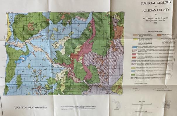
MGS is offering a limited supply of geologic map series for Allegan and Ingham counties at no cost to educators. These paper map packages include 24x37in copies of the 1983 surficial geology, drift thickness, bedrock topography, and bedrock geology maps produced by the Department of Natural Resources. These maps are available for pick up only at MGRRE. If interested, please contact us with which county and number of packages you would like.
Director John Yellich provides voice for Critical Minerals in Michigan
MGS director, John Yellich, participated in multiple interviews to spread the word on the importance of critical minerals in Michigan. He appeared in the Detroit News in May, discussing nickel resources. The article can be found here: https://www.detroitnews.com/story/business/autos/2023/05/21/stat es-bordering-lake-superior-could-have-as-much-nickel-asrussia/70225512007/
Additionally, John was interviewed by WJR radio to further discuss critical minerals in Michigan.
Send us a request if you would like a copy of the audio from the interview!
CoreKids Partners with Kalamazoo Playscape
The CoreKids program has a new partnership with Kalamazoo’s Children’s Nature Playscape. This partnership provides earth science programming to the young citizens of Kalamazoo. On June 16th, we held our first joint event with Playscape with the theme of fossils and dinosaurs. The fun activities included What is a fossil? How are fossils made? And what fossils are found here in Michigan? The children were able to touch and examine Mastodon and Mammoth molars. The event drew 130 young children and parents. The partnership will continue in the Fall with two events – one focusing on rocks and minerals and the other on planetary science and the moon.
Example surface geology map of Allegan County
3 Years Later- Validating and Bolstering the Michigan Water Well Database

Triage Project Update
The quality of any map or model is dependent upon that of the data used to build it. Oftentimes, maps and models lie at the core of public health and safety decisions surrounding water use, contamination, and protection. In 2019, as a result of data needs related to PFAs contamination concerns across Michigan, MGS performed a detailed evaluation of water well location data for several pilot townships within the state’s water well database, Wellogic. It was found that roughly 36% of well locations were in error by at least a 200ft distance, while often being placed in the wrong township or county entirely. Having an accurate location is critical for glacial depositional systems like the Michigan basin, where the geology can vary greatly over just a few hundred feet, therefore affecting how water (and contaminants) move in the subsurface. Further investigation revealed that in addition to significant errors in well locations, several other essential data fields needed review, including static water level, lithology, and screen depth. These findings gave rise to the grant funded Triage Project; an effort to correct the existing Wellogic database errors and digitize a large volume of unincluded historic data in the State of Michigan
Water well drillers from around the state examining core and sediments to practice geologic classification at the MGS Mud and Cores Interpretation Workshop as part of the Michigan Ground Water Association Meeting, 2023, in collaboration with EGLE water divisions.

These errors can be attributed to a complication of factors including but not limited to contribution to the database by multiple entities (water well drillers, local county health departments, EGLE staff, various university students and interns), all with their own variations in procedure, inaccuracies in latitude and longitude acquisition or use of low precision methods, and misinterpretation of geology. It’s important to remember that while geologists and other scientists use this data regularly, there is seldom a trained geologist on a household well drill site, and the people that actually collect the data are often not trained in best recording practices for scientific use. To help remedy this, MGS has been offering a workshop and training program at the annual Michigan Ground Water Association Conference, since 2015. In this program, drillers learn how to properly interpret their mud and cores and how to be mindful of common mistakes. This training program was also be offered at MGRRE.
Having worked on the Triage Project for three years, the team has reviewed, entered, and validated data for nearly 800,000 water well logs. Results thus far show that an average of 39% of well locations across 46 different counties were inaccurate, with an average correction distance of approximately 1,300ft. When reviewing both the location and other fields deemed essential for mapping and modeling purposes, in historic well records the correction rate jumps to 93% of all preexisting well records across those same counties; meaning at least one of those essential fields was incorrect in some capacity, referencing the scan of the original driller’s log in comparison with statewide parcel data.

Anyone can now view a spatial display of the Triage Project status. With the recent release of our new ESRI Dashboard web application, the public can download validated water well data for spatial joins to other datasets, ensuring that only validated data is used in a given project. The dashboard is updated with new data and corrections on the 1st of each month.
Triage Progress Dashboard: https://wmugeography.maps.arcgis.com/apps/dashboards/5f808d7f6ef74b10b90b4adadb3d0ba4
Instructional Video on How to Use the Dashboard: https://youtu.be/MA0Zl28IUtA
While a lot of ground has been covered in the last three years, there is still plenty of work to be done, with 37 counties still in need of review. We are now hiring Research Assistants to work on the Triage Project. This is a great position for students and recent graduates looking to work between 15-25 hours, remotely with a flexible schedule. You can learn more about this opportunity and details on how to apply here:
Research Findings >>>
Research Assistant (I) Job Posting Go to this Sway
Introducing Enhanced Accessibility Maps: Empowering Inclusive Outdoor Exploration
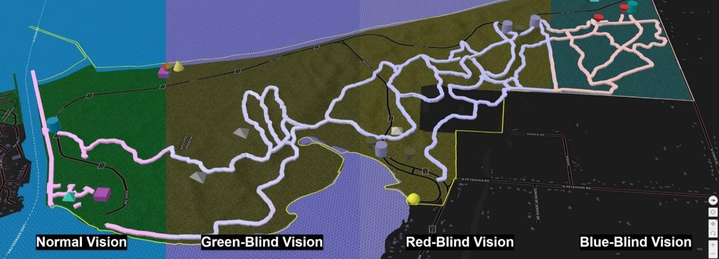

MGS is proud to unveil an initiative specifically designed to enhance accessibility to Michigan's captivating parks and recreation areas. The pilot program offers 3-dimensional topographic maps that provide a deeper understanding of the physical terrain and potential obstacles, enabling visitors to make informed decisions based on their individual capabilities. This reduces the user’s need to rely solely on general accessibility information or one-size-fits-all trail difficulty ratings. With these enhanced maps, users can better plan their routes and manage their expectations to ensure a rewarding and enjoyable outdoor experience.
The release of these maps is already underway, with Muskegon State Park being the first location to offer the publicly available enhanced accessibility map via MGS. Park management is actively involved, piloting the use of QR codes placed at various trail entrances. By scanning these codes, visitors can access the map, gaining insights into the terrain and features that lie ahead. In pairing, park management can receive data on user interaction, unmarked trails, and any potential hazards.
Inclusivity lies at the heart of this initiative, and our partnership with WMU’s Department of Blindness and Low Vision Services assists in ensuring that individuals with visual impairments can also benefit from these enhanced maps. Preliminary development of a complimentary, tactile version of these maps and addition of an audio navigation feature to the application is underway, further improving accessibility for all visitors.
MGS envisions expanding the availability of enhanced accessibility maps to cover more state parks and recreation areas across Michigan. The Porcupine Mountains State Wilderness Park, Tahquamenon Falls State Park, and the Pigeon River Country State Forest are among the locations targeted for inclusion. The ultimate goal is to provide comprehensive access to enhanced accessibility maps, ensuring that visitors can explore Michigan's natural wonders with confidence, regardless of their abilities.
Muskegon State Park Enhanced Accessibility Map: https://experience.arcgis.com/experience/281585a9ebf4443ea9f06445ed06a0a4
The project team is currently seeking support. If interested, contact Evie Murgia - Evangelia.M.Murgia@wmich.edu
Research Findings >>>
Core Stories
Use of Rock Cores in Carbon Sequestration Research Core Energy- State Charlton #4-30 Otsego County, Sec. 30-T31N-R1W Permit #57916
 Written and Interpreted by: Dr. William B. Harrison, III
Since 2005, researchers at the Michigan Geological Repository for Research and Education (MGRRE), which is part of the Michigan Geological Survey, in the Department of Geological and Environmental Sciences at Western Michigan University, have been studying the reservoir properties and assessing the potential of deep subsurface rock formations to safely store and contain CO2. Analyzing and interpreting observations from core samples and other data in the collections at MGRRE, the WMU team along with research scientists at Battelle Memorial Institute, have characterized many of the deep geological formations in the Michigan Basin and identified vast potential to store billions of tons of CO2, preventing it from entering the Earth’s atmosphere and contributing to climate change.
One of the key items of information that allows for gaining this knowledge is the collection of rock cores at MGRRE. Analysis and testing of these cores provide fundamental rock properties information to quantify pore space to store the CO2 and measure the flow patterns and properties of subsurface fluids. A core collected during the drilling of the Core Energy-State Charlton # 4-30 well (Sec. 30, T31N, R1W, Otsego County, in the Charlton 30/31 Niagaran Reef Oil Field, permit #57916) is a very good example of how core information can be used to characterize and support an actual field implementation project to sequester CO2 in a deep underground geological formation.
In 2006, a joint research project was undertaken by Battelle Memorial Institute, Core Energy, LLC, and Western Michigan University to drill a test well in an existing oil and gas field and test the capability of storing large amounts of CO2. The purpose of the well was to characterize a storage reservoir and the overlying confining layers. This was done by collecting a long section of rock core through the confining layers and the storage reservoir (Fig. 1). In addition to the core, various other formation properties were acquired with extensive wireline logging and assessing and monitoring fluid and reservoir properties in the borehole and the formations.

Once the core wass collected, it was transported to a testing facility for analysis. A key analytical testing procedure was carried out to measure porosity and permeability. Those values provide quantitative data about storage pore volume and fluid flow capacity through the pore network. (Fig. 2).
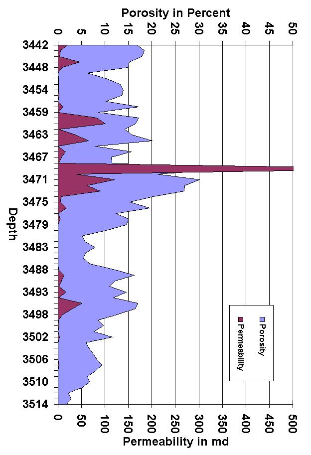
The target reservoir wass the Bass Islands Dolomite at a depth from 3,442 ft. to 3,516 ft. Porosity was measured above 10% in much of the core, but the permeability was very streaky depending on the facies and diagenetic alteration. The entire cored section in the Bass Islands Dolomite showed good to excellent porosity which provides substantial pore volume to store CO2
coming soon >>> New Core/Data
Three cores were received from the Beaver Creek field in Kalkaska County. MGRRE team reboxed, labeled, and inventoried the data. We also received new MDOT cores, which are currently being inventoried.
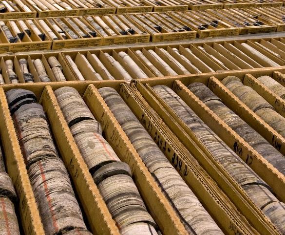 Figure 1: Examining core at the well site
Figure 2: Chart of porosity (light blue) and permeability (maroon) for Bass Islands interval of core
Core Stories
Use of Rock Cores in Carbon Sequestration Research Core Energy- State Charlton #4-30 Otsego County, Sec. 30-T31N-R1W

Permit #57916
Written and Interpreted by: Dr. William B. Harrison, III
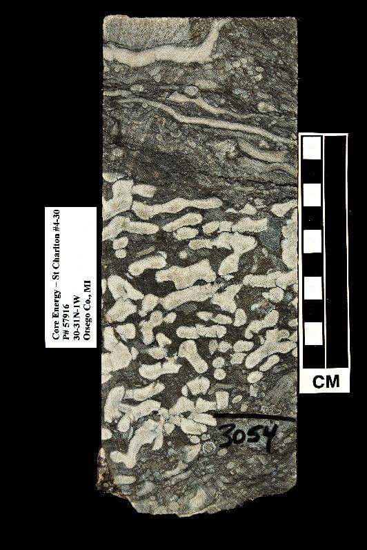
Physical characteristic of each cored formation is controlled by the original environment of deposition and subsequent diagenetic alteration. The Amherstberg Formation is mostly a dense, fossiliferous limestone that has very low porosity and permeability and makes a strong, impermeable seal above the reservoir formation (Fig. 3). The Bois Blanc Formation is the immediate overlying confining layer. It contained a mixture of chert (fibrous quartz) and dolostone or limestone with a heavily burrowed and bioturbated fabric (Fig. 4). It has relatively high porosity (greater than 10%), but very low permeability. During high pressure injection into the underlying reservoir of the Bass Islands Dolomite, some of the CO2 may flow into the porosity of the Bois Blanc Formation. However, when the pressure relaxes after injection ceases, fluid in the pore spaces may not be able to flow back out again. This is called capillary trapping and is controlled by the small size of the pore throats in the pore architecture of the Bois Blanc Formation. It then becomes an effective sealing formation as well.

The Reservoir formation is the Bass Islands Dolomite which is variably porous and permeable carbonate rock with intercrystalline, moldic and vuggy porosity (Fig. 5).

Once the well was completed, an injection test of supercritical CO2 was performed by Battelle and Core Energy, LLC, where over 60,000 tons of CO2 was injected and the results monitored. After the test was completed, Core Energy took ownership of the well and converted it to an oil producing well as part of their Charlton 30/31 CO2 enhanced recovery oil field.
Collecting and analyzing rock core samples along with field testing of injection of CO2 demonstrates that CO2 can be safely and efficiently stored in deep geological formations. This project provides a template for future activities in sequestering CO2 deep underground, which will be a key component of future carbon management in the mitigation of climate change.
Acknowledgement:
High resolution core photographs by Linda Harrison
Reference:
Harrison, William B. III, G. Michael Grammer, and David A. Barnes, 2009, Reservoir characteristics of the Bass Islands dolomite in Otsego County, Michigan: Results for a saline reservoir CO2 sequestration demonstration, Environmental Geosciences, v. 16, no. 3, pp. 139–151
Figure 3: Fossiliferous Amherstberg Formation
Figure 4: Burrowed and cherty Bois Blanc Formation
Figure 5: Bass Islands Dolomite in the layer with very high porosity and permeability
The Basal Conglomerate of the Munising Formation
Written and Interpreted by: Dr. Peter Voice
Ostrom and Slaughter (1967) in their road log for a Michigan Basin Geological Society Guidebook described a small outcrop of the Basal Conglomerate of the Munising Formation on the west side of Munising Bay along the west-side of old Highway M-28 in the SW ¼ SW ¼ of section 26, T47N, R19W in Alger County. At the site, Jacobsville Sandstone is present along the shoreline east of the road. The contact is covered. On the west side of the road, the upper Basal Conglomerate and the Chapel Rock Member of the Munising Formation are present.
I first visited the outcrop in 2014 during a Michigan Earth Science Teachers Association Field Trip to the Pictured Rocks National Lakeshore. At that time the outcrop was extensively overgrown and only a few feet of the Basal Conglomerate were visible in the ditch along Westshore Drive. The Basal Conglomerate consists of trough cross-bedded, matrix supported conglomerate with rounded pebbles of quartzite and vein quartz. In Fall 2022, I took a graduate class in Clastic Depositional Environments on a field trip to the Pictured Rocks Area. During this trip, I decided to take the students to see the outcrop. Unfortunately, it was too windy to do a boat tour out to see the Basal Conglomerate at Grand Isle and I wanted the students to see an example of this unit. I was stunned to find that the hillside had been scraped clean during utility work in the area. On a second visit to the outcrop earlier this summer, my field camp students were able to spend some time examining the outcrop – the pictures below come from that visit. During our visit, the weather was rainy and the outcrop is wet from this precipitation.
Location (Figure 1): At Westshore Drive Pavilion (Stone Quarry Park) along Westshore Drive. Westshore Drive forms a loop off M-28 north of Munising. The northern end of the drive is directly across the street from the entrance to the Grand Island Harbor Scenic Turnout. Parking is available at the Pavilion. The Basal Conglomerate Outcrop is on the west side of the road across from the Pavilion.

Geology: At this site, you can observe the Jacobsville Sandstone and the Basal Conglomerate and Chapel Rock Members of the Munising Formation. The Jacobsville Sandstone is exposed along the lakeshore in two benches (one directly at the shore with a very steep drop-off and the second about 8 ft above lake level). Follow the path to the shoreline to see the Jacobsville Sandstone. The contact between the Jacobsville and the Basal Conglomerate is covered. Along the west side of Westshore Drive is the outcrop of the Basal Conglomerate. The Basal Conglomerate grades into the Chapel Rock Sandstone.
The Jacobsville Sandstone is a maroon, lithic sandstone with reduction spots and trough cross-bedding (Figure 2). The Basal Conglomerate of the Munising Formation consists of tan, matrix-supported pebble conglomerate with trough cross-bedding (Figure 3). The cross-bedding is normally graded – with troughs initially pebble dominated and grading to coarse sand. Pebbles are rounded and range up to 9 cm in length. The pebbles are dominantly Pre-Jacobsville quartzite or vein quartz. The Basal Conglomerate grades into the cross-bedded sands of the Chapel Rock Member.

Outcrop
Stories
Figure 1: Location of the Westshore Drive Basal Conglomerate Outcrop. Satellite imagery courtesy of Google Maps.
Figure 2: Jacobsville Sandstone at Westshore Drive Pavilion in upper bench. Photograph taken during MESTA 2014 field trip.
The Basal Conglomerate of the Munising Formation
 Written and Interpreted by: Dr. Peter Voice
Significance: Hamblin (1958) mapped the distribution of the Basal Conglomerate Member of the Munising Formation – he showed that the unit was present primarily in a 60-mile stretch in the Pictured Rocks area. He also identified the Basal Conglomerate at the Limestone Mountain outlier in southeastern Houghton County, suggesting that the unit had a more extensive range now eroded away. Haddox and Dott (1990) and Dott and Haddox (1991) interpret the Basal Conglomerate as fluvial deposits sourced from the erosion of the Northern Michigan Highlands. The Northern Michigan Highlands formed during their Keweenawan rifting as a series of fault block mountains bordering the edge of the rift. During the Cambrian transgression, the Munising Formation was deposited including the fluvial Basal Conglomerate, the fluvio-deltaic Chapel Rock Member, and finally the marine Miners Castle Member.
Hamblin’s (1958) work with paleocurrent data shows that sediment was transported away from the Northern Michigan Highlands during Basal Conglomerate and Chapel Rock deposition. During Miners Castle Deposition, the paleocurrent indicators record westward transport of sediment. The overlying Ordovician Au Train Dolomite records paleocurrent directions to the south reflecting the establishment of the Michigan Basin depocenter and the basinward flow of currents by the Ordovician.
2023
References:
Dott, R.H., Jr., and Haddox, C.A. 1991, Geology of the Pictured Rocks, Upper Peninsula, Michigan, Michigan Basin Geological Society Guidebook, 40 p.
Haddox C.A. and Dott, R.H., Jr., 1990, Cambrian Shoreline Deposits in Northern Michigan, Journal of Sedimentary Petrology, 60(5): 697-716.
Hamblin, W.K., 1958, The Cambrian Sandstones of Northern Michigan, Geological Survey Division Publication 51, 146 p.
Ostrom, M.E. and Slaughter, A.E. (eds.), 1967, Correlation Problems of the Cambrian and Ordovician Outcrop Areas, Northern Peninsula of Michigan, Michigan Basin Geological Society Annual Field Excursion, 82 p.
Outcrop
Stories
Figure 3: Basal Conglomerate of the Munising Formation at Westshore Drive. Photograph taken during the WMU Field Camp, June,
In Memory of Dr. Lloyd Schmaltz 1929-2023

In 1965, the Department of Geology was created after its division from Geography. Dr. Lloyd Schmaltz was the first Chair of the department and remained a part of the department until 1987. Dr. Schmaltz designed the geology curriculum and helped grow the program to be recognized as one of the top geoscience programs in the Midwest. He was always supportive of the creation of the core repository and helped secure a small room in Rood Hall in 1982 and then a larger space in West Hall, where MGRRE remained until 2006.



Dr. Schmaltz was also well known for leading field trips, particularly down the Grand Canyon. He has inspired numerous students and forged lasting relationships with council members, donors, faculty, and students. He received an Outstanding Educator award from the Michigan Section of AIPG in 2019, recognizing his impactful contributions to students when he was an educator.

Dr. Schmaltz had an incredible journey in geology. After his serving in the U.S. Marines, He began at Augustana University and then moved to the University of Missouri where he obtained his Masters and PhD in Geology. Shortly after, he accepted a position at Western Michigan University in 1959. His focus was in geomorphology and glacial geology and his research interests included regional geology and landforms. He studied pediments in
Arizona which led to his first, of many, field trips into the Rocky Mountains and the Southwest in the 1970s. He was instrumental in developing an impressive geologic collection which created the Lloyd J. Schmaltz Geology Museum in 1988. The museum has since expanded to host even more specimens, notably a spectacular mineral collection from Jim Duncan, Jr. Most recently, the museum expanded to host the notorious dinosaur park.
Even after his passing, he continues to support students through scholarships. Please consider donating to the Lloyd and Marilyn Schmaltz MGRRE Scholarship to continue his legacy.
 Dr. Lloyd Schmaltz teaching geology in 1964
Dr. Lloyd Schmaltz and his wife Marilyn
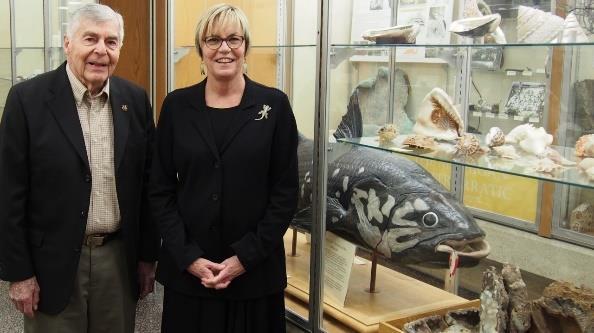
Dr. Lloyd Schmaltz and Dr. Julie Stein at the Lloyd Schmaltz Museum
William.Harrison_III@wmich.edu
Nathan Erber MGS Senior Research Associate 387-8604
Nathan.R.Erber@wmich.edu
Evangelia Murgia MGS Hydrogeologist

269-387-8606
Evangelia.M.Murgia@wmich.edu
Jennifer Trout MGS Research Associate MGRRE Collections Manager
269-387-8633
Jennfier.l.trout@wmich.edu
Linda Harrison Administrator




269-387-8642
Linda.Harrison@wmich.edu
Peter Voice Research Associate Teaching Faculty Specialist


269-387-5486
Peter.Voice@wmich.edu
Marie Solum Outreach Coordinator

Ashley Quigley Precambrian Geologist


269-387-8634

269-387-8608
Upcoming Events >>>
Marie.Solum@wmich.edu
Ashley.Quigley@wmich.edu
Find us across multiple platforms!


 Autumn Haagsma delivering opening remarks
 By: Peter Voice and Marie Solum


 Figure 1: Examining core at the well site
Figure 2: Chart of porosity (light blue) and permeability (maroon) for Bass Islands interval of core


 Written and Interpreted by: Dr. Peter Voice


 Dr. Lloyd Schmaltz teaching geology in 1964
Dr. Lloyd Schmaltz and his wife Marilyn
Dr. Lloyd Schmaltz and Dr. Julie Stein at the Lloyd Schmaltz Museum


