PLAN OF MANAGEMENT

Bulahdelah Showground October 2021
Plan of Management Report Prepared by Lands Advisory Services Pty Ltd
265 King Street
Newcastle NSW 2300
Email: enquiries@landsas.com.au

October 2017
© Lands Advisory Services Pty Ltd 2017
Disclaimer:
Drawings, figures, analysis, forecasts and other details in this report have been prepared in good faith based on data and information supplied to Lands Advisory Services Pty Ltd by others. The data is believed to be correct at the time of publication of this report. However, it is noted that predictions, forecasts and calculations are subject to assumptions which may or may not turn out to be accurate. Lands Advisory Services Pty Ltd expressly disclaims all and any liability to any person or persons in reliance on the report and its contents in part or in whole.
Plan of Management Bulahdelah Showground
MidCoast Council
Plan of Management Bulahdelah Showground MidCoast Council Page 3 TABLE OF CONTENTS EXECUTIVE SUMMARY 5 1 INTRODUCTION 6 Public Land .............................................................................................................................................7 Plans of Management 9 Categorisation and Objectives 9 Types of Plans 10 2 SITE DESCRIPTION...................................................................................................................11 Land Parcels..........................................................................................................................................11 Adjoining Operational Land..................................................................................................................11 Ownership and Management...............................................................................................................11 3 PLANNING INSTRUMENTS AND POLICIES 14 Land Zoning 14 Flood Planning 15 State Environmental Planning Policies 16 Council Policies 17 4 THE PHYSICAL ENVIRONMENT 18 Topography, Hydrology and Drainage ..................................................................................................18 Land Clearing and Modification............................................................................................................20 Soils and Geology 21 Vegetation and Habitat 21 Biodiversity 22 5 THE SOCIAL ENVIRONMENT...................................................................................................23 Aboriginal Significance..........................................................................................................................23 Heritage Significance ............................................................................................................................23 Contemporary Significance...................................................................................................................23 6 CURRENT USES........................................................................................................................25 Current User Groups 25 Other Uses 26 Existing Interests and Tenures 26 7 RESERVE ASSESSMENT 27 Assessment of Infrastructure................................................................................................................27 User Assessment...................................................................................................................................32 Status Assessment 33 8 A VISION FOR THE LAND ........................................................................................................34 9 OBJECTIVES, CLASSIFICATION AND CATEGORY OF LAND .....................................................36 Sportsground 36 General Community Use 38 10 MANAGEMENT AND DEVELOPMENT OF THE RESERVE ........................................................40 Reserve Management...........................................................................................................................40 Permitted Uses and Activities...............................................................................................................41 Leases, Licences and other Estates.......................................................................................................43 Allocation 46 Fees 46
TABLE OF FIGURES
Plan of Management Bulahdelah Showground MidCoast Council Page 4 Communication in the Management of the Reserve ...........................................................................47 Easements ............................................................................................................................................47 Development of New and Improvement of Existing Facilities..............................................................47 Maintenance of Existing Facilities 50 Signage 51 11 FINANCIAL SUSTAINABILITY...................................................................................................52 Funding Options 52 Emerging Opportunities to Increase Income........................................................................................53 12 IMPLEMENTATION PLAN 55 13 CONSULTATION DURING THE PREPARATION OF THIS PLAN 59 14 APPENDICES 60 15 REFERENCES 61
Figure 1 – Locality Diagram 7 Figure 2 – Site Diagram 8 Figure 3 – Flood Planning 15 Figure 4 – North East Drainage ........................................................................................................................ 19 Figure 5 – South West Drainage........................................................................................................................19 Figure 6 – Town Map of Bullah Delah 1864 ......................................................................................................20 Figure 7 – Vegetation and Habitat ....................................................................................................................22 Figure 8 – Contemporary Significance 24 Figure 9 – Plan View - Assets of Bulahdelah Showground 28 Figure 10 – Assets of Bulahdelah Showground – Main Arena Area 29 Figure 11 – Assets of Bulahdelah Showground - Pavilion Area 29 Figure 12 – Assets of Bulahdelah Showground – Playing Fields Area 30 Figure 13 – Assets of Bulahdelah Showground – Tennis, Swimming and Stage areas......................................31 Figure 14 – Assets of Bulahdelah Showground - Other 32 Figure 15 – Land Categories 37 Figure 16 – Bulahdelah Showground - Memorial Gates 39 Figure 17 – Planned Improvements 48
EXECUTIVE SUMMARY
The Bulahdelah Showground is a substantial complex of crucial significance to the town of Bulahdelah and the region. It creates a common focus for community commitment and relationships, hosting a diverse range of events, interests and activities, all integral to the health and lifestyle of a small rural centre. The annual agricultural show, rodeo and other horse sports, tennis, football, cricket, swimming and recreational camping all take place on the site.
Bulahdelah Showground is on a Crown reserve owned by the State Government and managed by MidCoast Council for the benefit of the community.
The intention of this Plan of Management is to provide Council with a framework that enables decisions in regard to the site, to be made on an informed, consistent and equitable basis. The Plan meets all of the requirements of the Local Government Act 1993
The land at Bulahdelah Showground is categorised as:
• Sportsground
• General Community Use
A description of each category of land as it exists on the Reserve is provided. The current use patterns, built and natural assets and their condition, emerging trends, constraints and influences, have been considered in this Plan of Management. Appropriate management objectives and actions, as well as an effective management structure and communication strategy for successful implementation are key outcomes provided by the Plan.
This Plan is presented in two principal sections being the site description (A), which describes the constraints of the site, and the fundamental components of the Plan (B), which describes what is planned for the site’s future.
Plan of Management Bulahdelah Showground MidCoast Council Page 5
PART A – THE SITE 1 INTRODUCTION
Bulahdelah was originally proposed to be part of the Port Stephens to Manning River Australian Agricultural Company Grant of 1828. This section was relinquished in 1836 in favour of the Peel River and Warra Estates in 1836 and the area became available for closer settlement after 1850.
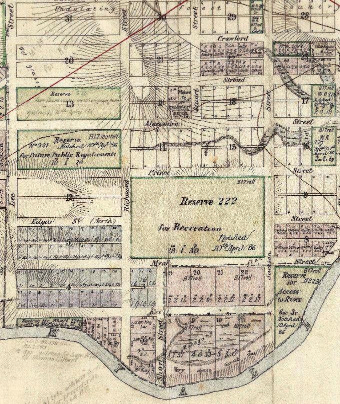
The site for the Village of Bullah Delah was established from Crown land in November 1864. Reserve 222 for Recreation Purposes was notified in April 1886 bounded by Prince, Jackson, Myall and Richmond streets.
Reserve 222 was replaced with Reserve 55102 for Public Recreation and Showground on 13 January 1922.
The area of the current Reserve remains the same today with the exception of a small portion at the south-eastern corner – the site of the current Bowling Club.
The land included in this Plan is located to the west of the Bulahdelah Town Centre and between the Pacific Highway and the Myall River in New South Wales. It consists of a showground complex which caters for the multi-functional interests and activities of the people of Bulahdelah and further afield, including the annual agricultural show, horse sports, tennis, camping, football and swimming events.
This PoM has been prepared in order to achieve a balanced, responsible and ecologically sustainable use of the land and to ensure that it addresses the needs of the local neighbourhood, the broader community, and the environment. It has been prepared in order to meet the requirements of the Local Government Act 1993.
This PoM for the Bulahdelah Showground complex (the Reserve), will be its first Plan of Management. Council will undertake the required process as per Section 36 of the Local Government Act 1993 for this PoM.
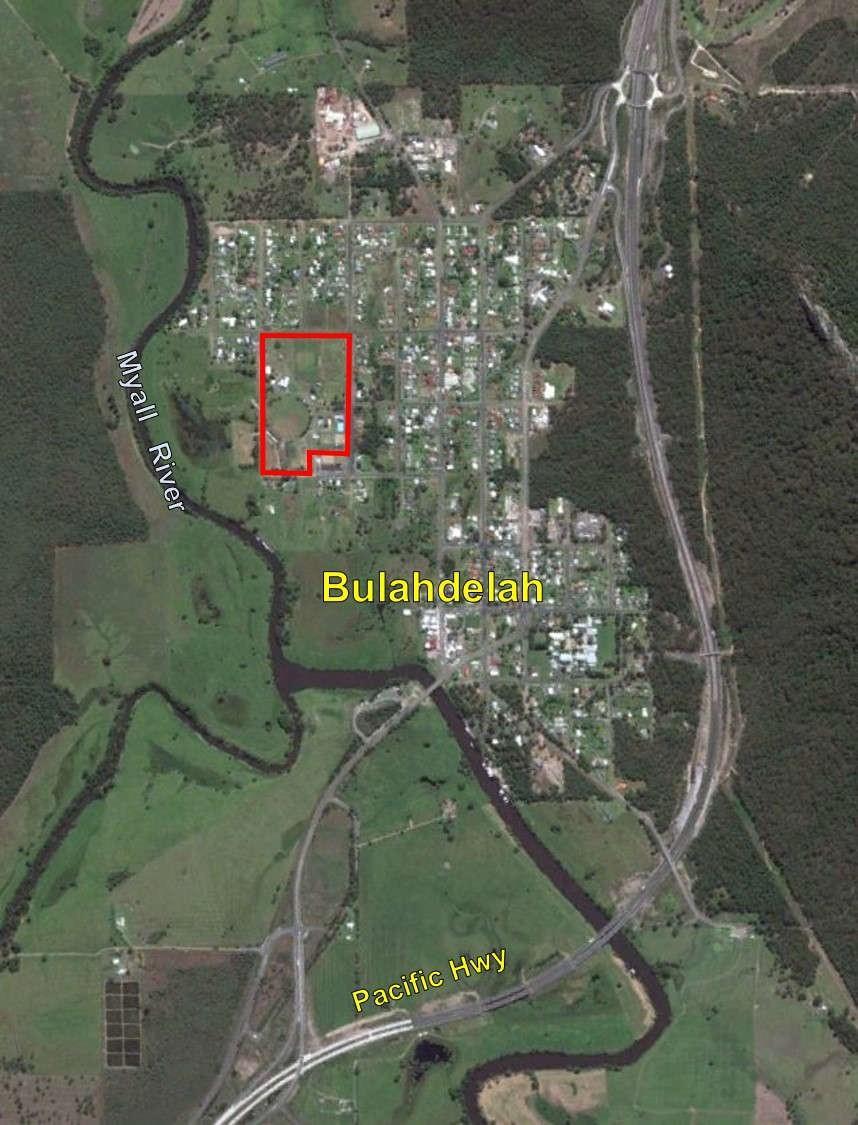
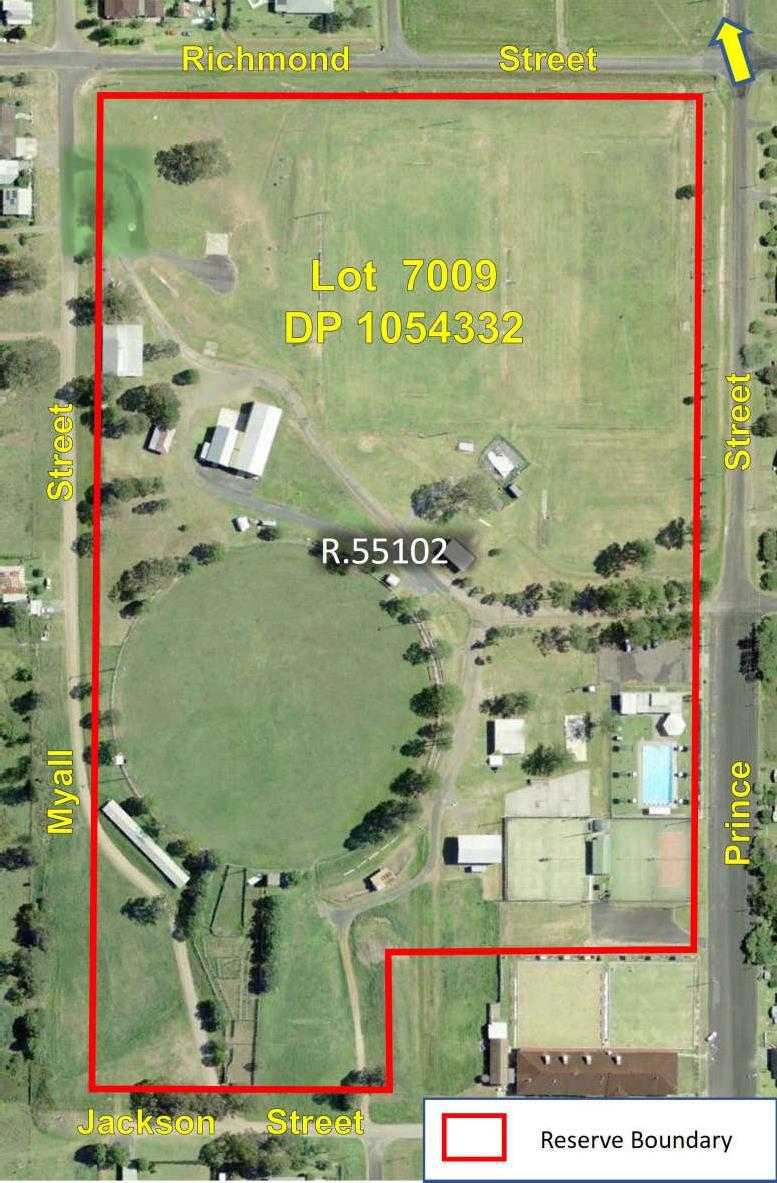
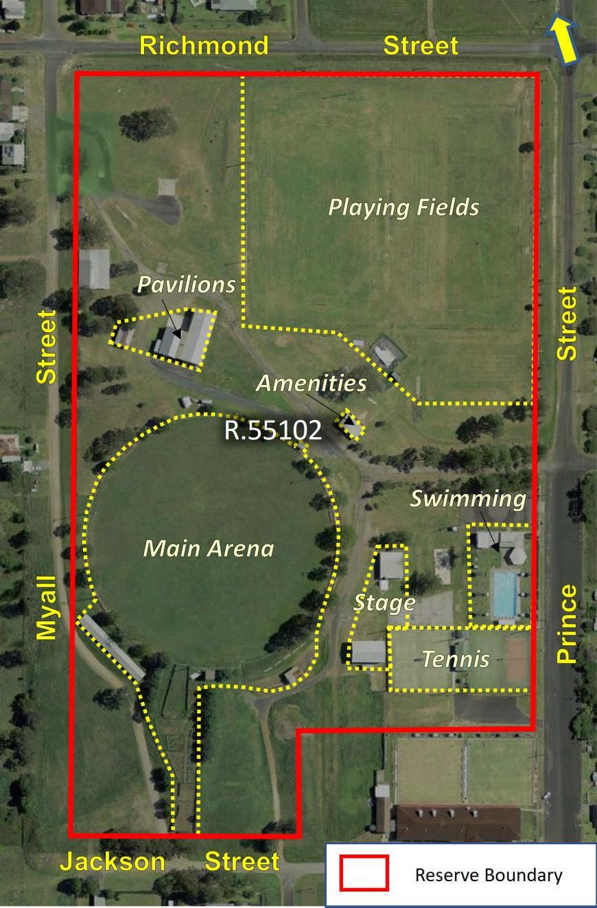
The location of the Reserve is shown in Figure 1 and a more detailed site map, Figure 2.
Plan of Management Bulahdelah Showground MidCoast Council Page 6
Public Land
This land, briefly described above, is Crown land managed by MidCoast Council.
Crown land is owned by the State of New South Wales for the benefit of all persons. Local Government Authorities manage Crown land on behalf of the State, as Crown Land Managers, under Division 3.4 of the Crown Land Management Act 2016 (CLMA). The CLMA provides that Council should manage the land under the Local Government Act 1993 (LGA).
Under the LGA, all public lands must be classified as either Community or Operational land. The land shown in Figure 2 has been classified ‘Community’ land under the provisions of the LGA.

Plan of Management Bulahdelah Showground MidCoast Council Page 7
Figure 1 – Locality Diagram
The purpose of the classification is to clearly delineate which land should be kept for use by the general public (Community) and which land need not be kept (Operational). The major consequence of the classification is that it determines the ease or difficulty by which the land may be alienated by sale, lease or other means. Community land would ordinarily comprise land such as a sportsground, hall, public park etc.,1 and Operational land would consist of land which facilitates carrying out of a public
1 See the note to Chapter 6, Part 2 of the LGA
Plan of Management Bulahdelah Showground MidCoast Council Page 8
Figure 2 – Site Diagram
service, such works depots, or land held as a temporary asset or investment.
Community land:
• cannot be sold
• cannot be leased, licenced or any other estate granted over the land for more than 30 years2
• must have a Plan of Management prepared for it.
Plans of Management
The LGA requires that Plans of Management are to be created over Community Land.
Plans of Management over Crown land can be created:
• under Division 3.6 of the CLMA by a non-council manager3; or


• under Chapter 6 Part 2 of the LGA by a council manager4
The PoM provides direction and continuity for the planning, management and maintenance of public open space under the management of local government.
Categorisation and Objectives
As required by legislation for the purposes of the PoM, community land is categorised as one of the following:
• Park
• Sports Ground
• General Community Use
• Area of Cultural Significance
• Natural Area
Bushland
Wetland
Watercourse
Escarpment
Foreshore.
The initial categorisation for Bulahdelah Showground under Section 3.23 of the CLMA was General Community Use.
2 Leases of greater than 21 years require Minister’s consent
3 The CLMA allows a Council manager to create a PoM over Crown land where there is no requirement under the LGA.
4 Legislation changes in 2018 have allowed PoM over Crown land to be created under the LGA
Plan of Management Bulahdelah Showground MidCoast Council Page 9
o
o
o
o
o
Types of Plans
The LGA allows a PoM to cover one or multiple parcels of land.

Where multiple parcels of land are covered in one plan (Generic Plans), the LGA specifically states what needs to be included. Where a PoM covers one parcel of land (Specific Plans), like this Plan, there is greater detail on what has to be prescribed in the Plan. A Generic Plan sets the framework of how the land is to be managed. A Specific Plan clearly outlines very precise management proposals.
PoMs for community land are periodically reviewed to enable changing social, economic and ecological conditions to be taken into account and consequently amendments to the Plan may occur.
Council currently has a suite of Generic and Specific Plans of Management. A register of these plans is kept in the Parks and Recreation Section and are updated accordingly.
Plan of Management Bulahdelah Showground MidCoast Council Page 10
2 SITE DESCRIPTION


Table 1 - Site Description Reserve Reserve R.55102 for Public Recreation and Showground – established 13 January 1922
Description Lot 7009 DP 1054332
Address Prince Street, Bulahdelah 2423
Initial Category General Community Use
Proposed Categories Sportsground and General Community Use
Land Parcels
The land to which this Plan of Management applies, lies within the MidCoast Local Government Area at Bulahdelah, New South Wales. The property address of the land is Prince Street, Bulahdelah and covers Lot 7009 in Deposited Plan 1054332.
The eastern boundary and main entry to the land is Prince Street with other entries from Myall and Jackson Street. These three streets are residential streets in the northwestern part of Bulahdelah. The south-eastern corner of the land adjoins Grand United Bulahdelah Bowling Club. The western edge of the land fronts Myall Street, which also fronts other larger parcels of land. The south-western corner of the land is approximately 200 metres from the Myall River, which is the western boundary of the town.
The total area of the land is around 10.68 Ha.
Adjoining Operational Land
There is no adjoining land classified as operational, as per the LGA.
Ownership and Management
Bulahdelah Showground is on Crown land owned by the State of New South Wales. The land is subject to a Reserve (R.55102) for Public Recreation and Showground, under the CLMA, established on 13 January 1922. All assets on the Reserve are owned by the State of New South Wales.
Council is the appointed Crown land manager under the CLMA. Council, as the Council of the Shire of Great Lakes was appointed trustee of the Reserve on 14 January 1977.
Native title
Crown land in Australia is subject to Native title under the Native Title Act 1993 (Commonwealth). On Crown land Native title rights and interests must be considered unless:
• Native title has been extinguished; or
• Native title has been surrendered; or
• Determined by a court to no longer exist.
Plan of Management Bulahdelah Showground MidCoast Council Page 11
Some examples of acts which may affect native title on Crown land or Crown reserves managed by Council include:
• the construction of new buildings and other facilities such as toilet blocks, walking tracks, tennis courts, grandstands and barbecues,
• the construction of extensions to existing buildings,
• the construction of new roads or tracks,
• installation of infrastructure such as powerlines, sewerage pipes, etc.,
• the issue of a lease or licence,
• the undertaking of major earthworks.
When proposing any act that may affect native title on Crown land or Crown reserves the act must be authorised through Part 2 Division 3 of the Native Title Act 1993 (Cwlth).
Aboriginal Land Rights
The Aboriginal Land Rights Act 1983 (ALRA) seeks to compensate Aboriginal peoples for past dispossession, dislocation and loss of land in NSW. The lodgment of an aboriginal land claim (ALC) under section 36 of the ALRA, over Crown land creates an inchoate interest in the land for the claimant pending determination of the claim. The Department of Planning and Environment – Crown lands (DPE-CL) advises that, if the land is subject to an undetermined ALC, any works, development or tenures authorised by the PoM should not go ahead if:
• the proposed activity could prevent the land being transferred to an ALC claimant in the event that an undetermined claim is granted
• the proposed activity could impact or change the physical/environmental condition of the land, unless:
o the council manager has obtained written consent from the claimant Aboriginal Land Council to carry out the proposed work or activity, and/or
o the council manager has obtained a written statement from the Aboriginal Land Council confirming that the subject land is withdrawn (in whole or partial) from the land claim
• the proposed activity is a lease to be registered on title unless the council manager has obtained written consent from the claimant Aboriginal Land Council
At the time of drafting DPE-CL advised there were no undetermined ALCs over Bulahdelah Showground.
Management Committee
Section 3.21 of the CLMA authorises Council to manage the land as if it were public land within the meaning of the LGA Under the LGA, all public lands must be classified as either Community or
Plan of Management Bulahdelah Showground MidCoast Council Page 12
Operational land and this land has been classified ‘Community’ land.
The Bulahdelah Showground Management Committee (BSMC) is an Asset Committee established by Council under Section 355 of the LGA. Following amalgamation of Great Lakes Shire, Greater Taree City and Gloucester Shire Councils into MidCoast Council on 12 May 2016, Council's representation on all Section 355 committees, via a Councillor was suspended until such time as a newly elected body was formed in September 2017.5
5 Council is currently in the process of determining which Committees will have Councillor representation and if so which Councillor will a member of BSMC.
Plan of Management Bulahdelah Showground MidCoast Council Page 13
3 PLANNING INSTRUMENTS AND POLICIES
Land Zoning
Under the Great Lakes Local Environmental Plan 2014 (LEP)6 , the Reserve in total is zoned RE1 – Public Recreation.
The objectives of the RE1 – Public Recreation zone are:
• To enable land to be used for public open space or recreational purposes.
• To provide a range of recreational settings and activities and compatible land uses.
• To protect and enhance the natural environment for recreational purposes.
• To provide for a range of educational, environmental, community and cultural uses for the benefit of the community.
• To enable access to activities and businesses located within adjacent waterways.
There are no activities permitted without consent.
The following activities are permitted with consent:
• Boat launching ramps
• Camping grounds
• Car parks
• Caravan parks
• Community facilities
• Depots
• Eco-tourist facilities
• Emergency services facilities
• Environmental facilities
• Environmental protection works
• Flood mitigation works
• Function centres
• Heliports
• Information and education facilities
• Jetties
• Kiosks
• Marinas
• Markets
• Plant nurseries
• Recreation areas
• Recreation facilities (indoor)
• Recreation facilities (major)
• Recreation facilities (outdoor)
• Registered clubs
• Research stations
• Restaurants or cafes
• Roads
• Sewerage systems
• Signage
• Waste or resource management facilities

• Water recreation structures
• Water supply systems
• Wharf or boating facilities.
Subject to State and Regional Environmental Planning Policies that apply to this land all other development is prohibited.
6 The recent amalgamations for three former contiguous local government areas will mean that respective policy documents including LEPs, will merge formally into those of the new MidCoast Local Government Area. At the time of compiling this Plan of Management, the titles of respective LEP’s remain.
Plan of Management Bulahdelah Showground MidCoast Council Page 14
The Reserve is bound by the RU5 (Village) completely with the exception of the Grand United Bulahdelah Bowling Club land which is also RE1 – Public Recreation.

Flood Planning
Figure 3 shows that the land is significantly contained within the Flood Planning Area with the exception of the north-west corner.
Plan of Management Bulahdelah Showground Page 15
Figure 3 – Flood Planning
The LEP requires that development consent must not be granted to development on affected land unless
the consent authority is satisfied that the development:
(a) is compatible with the flood hazard of the land, and
(b) will not significantly adversely affect flood behaviour resulting in detrimental increases in the potential flood affectation of other development or properties, and

(c) incorporates appropriate measures to manage risk to life from flood, and
(d) will not significantly adversely affect the environment or cause avoidable erosion, siltation, destruction of riparian vegetation or a reduction in the stability of river banks or watercourses, and
(e) is not likely to result in unsustainable social and economic costs to the community as a consequence of flooding.
The land is subject to the Great Lakes Development Control Plan 2014 (DCP) section 4.2 – Flooding. The DCP contains subdivision and building controls relating to flooding and also has conditions relating to fencing.
State Environmental Planning Policies
Bulahdelah Showground is subject to the State Environmental Planning Policies below. Those that are considered more relevant to the future of the Showground and this PoM are underlined below and briefly described in Appendix 4.
• State Environmental Planning Policy (Affordable Rental Housing) 2009
• State Environmental Planning Policy (Building Sustainability Index: BASIX) 2004
• State Environmental Planning Policy (Coastal Management) 2018
• State Environmental Planning Policy (Concurrences and Consents) 2018
• State Environmental Planning Policy (Educational Establishments and Child Care Facilities) 2017
• State Environmental Planning Policy (Exempt and Complying Development Codes) 2008
• State Environmental Planning Policy (Housing for Seniors or People with a Disability) 2004
• State Environmental Planning Policy (Infrastructure) 2007
• State Environmental Planning Policy (Mining, Petroleum Production and Extractive Industries) 2007
• State Environmental Planning Policy (Primary Production and Rural Development) 2019
• State Environmental Planning Policy (Vegetation in Non-Rural Areas) 2017
• State Environmental Planning Policy No 21 Caravan Parks
Plan of Management Bulahdelah Showground Page 16
• State Environmental Planning Policy No 33 Hazardous and Offensive Development
• State Environmental Planning Policy No 36 Manufactured Home Estates
• State Environmental Planning Policy No 50 Canal Estate Development
• State Environmental Planning Policy No 55 Remediation of Land
• State Environmental Planning Policy No 64 Advertising and Signage

• State Environmental Planning Policy No 65 Design Quality of Residential Apartment Development
Council Policies
Council has developed a number of plans and general policies which have either direct or indirect relevance to planning, management and maintenance of Community Land and Council Reserves. Of particular note;
• The Great Lakes Plan of Management (guideline), adopted in 2012 provides an overarching framework for the compilation of plans of management for community lands, listing all relevant legislation and policy.
• Recreation and Open Space Strategy (ROSS), compiled for Council in 2006 contains projections until 2026, providing much insight into proposed management of recreation and open space areas in the (former Great Lakes) local government area, including the Bulahdelah Showground.
• MidCoast Council Community Engagement Policy, adopted in 2017 outlines the principles and activities that guide community engagement practices to ensure effective community contribution to the Council Decision making process.
• MidCoast Council Leasing/Licensing of Council Land & Buildings Policy, adopted in 2017 provides for a consistent, transparent and fair approach to the leasing or licensing of Council Property and to maximise the community benefit by encouraging the multiple use of community facilities.
• MidCoast Council Terms & Conditions for use of Recreational Spaces Procedure, approved in 2016 provides for the operational aspects of organised usage of Council's sporting and recreational facilities.
All relevant policies can be found at Council’s website at www.midcoast.nsw.gov.au7 .
This Plan of Management is consistent with these plans, strategies and policies.
7 The majority of relevant policies appear in the references of this Plan.
Plan of Management Bulahdelah Showground Page 17
4 THE PHYSICAL ENVIRONMENT
Topography, Hydrology and Drainage
The Land lies within the Myall River catchment and is about 700m upstream of where the Crawford River joins the Myall from the west. A further 3km upstream Frys Creek joins the Myall from the east. After joining the Crawford, the Myall River flows south east into the Boombah Broadwater and the Coast.
The Land is not impacted by the Coastal Management Act 2016 because of its distance from the coastline. However, the Reserve is located on a floodplain and is therefore subject to Clause 7.3 (Flood Planning) of the LEP.
Clause 7.3 objectives are to:
• minimise the flood risk to life and property associated with the use of the land,

• allow development on land that is compatible with the land’s flood hazard, taking into account projected changes as a result of climate change, and
• avoid significant adverse impacts on flood behavior and the environment.
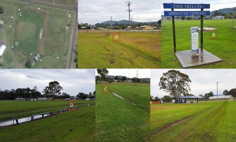
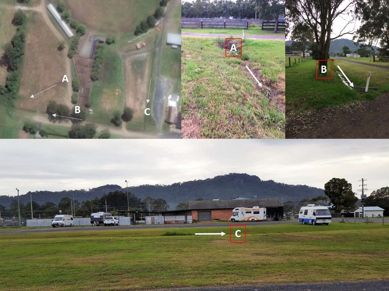
The Land is gently undulating to flat and falls from the centre to both the north east (see Figure 4) and south west corners (see Figure 5).
The area denoted A on Figure 4 shows the exit point of drainage water to the north east which drains well. However, blockage points denoted B and to end of the swale denoted D create water logging problems in times of medium to high rainfall. An “Ag” drain under the swale at C may allow those dish drains to better cope with water flows coming from the helipad area.
Plan of Management Bulahdelah Showground Page 18


Plan of Management Bulahdelah Showground Page 19
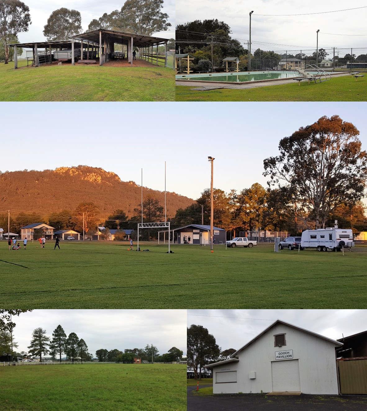
(Clockwise from top left) Drainage flow around sports field, drainage exit north-east, drainage blockage point near football (soccer) club, drainage swale protecting the sports field to Richmond St, drainage swale draining south, drainage swale between sports fields.
Figure 5 – South West Drainage
Figure 4 – North East Drainage
(Clockwise from top left) Drainage flow around holding yards, drainage channel and culvert south west, drainage channel along Jackson St, drainage channel through bowling club land.
Land Clearing and Modification

The 1864 plan for the establishment of Bullah Delah shows the area as being flat and being the transition area between Undulating forest country at Crawford Street and Mahogany and Tea Swamp towards the Myall River to the south of the land.
During initial site development and the subsequent conversion into a Showground, the natural environment of the Reserve experienced obvious modifications, commencing with the initial clearing of the land for its preparation. In following decades, the land surface has been modified to allow establishment of the showground ring, and for the installation of other infrastructure and facilities. It
Plan of Management Bulahdelah Showground Page 20
Figure 6 – Town Map of Bullah Delah 1864
is likely that a dominant grassland of mainly high-water table species which typify floodplain environments, interspersed with single or clumps of trees would have been the original vegetative cover, typical of any natural small floodplain in the area.
Apart from the establishment of the sportsfields in the north-east corner there does not appear to be any major modifications to the topography.
Soils and Geology

The dominant soil type is typical of the lower terrace of the Upper Myall River. These are the lower terrain soils of alluvial (deposited) origin which correspond to the flood prone areas of Figure 3 (blue). The Bulahdelah (1:100,000) Sheet of the NSW government’s state-wide soil survey program8 captures several soil profile descriptions which are also located on or near the same floodplain some 150 to 200 metres to the Showground’s south. Although the surface soil materials particularly on these flatter less well drained sections of the Showground would have been modified due to development within the Reserve, possibly including fill with foreign soil materials, the following is a generalised condensation of the description provided for the deep soils of this area:
0-30 cm Brownish-black clay loam of moderate structure, clay 20%, PH 5.3
30-70 cm Dark brown light clay, strong pedality (structure), smooth-faced peds, clay 35%, PH 5.5
70-110 cm Dark-greyish brown light clay, strong pedality, smooth faced peds, clay 40%, non-sodic, PH 5.2.

The soils which occupy the slope and crest in the north-western section of the Showground area have generally developed in situ and as such, express their siltstone/mudstone origins. They occur as strongly texture contrast soils with a sharp texture and colour boundary between surface and subsoils, at around 20 cm depth. They are fine sandy clay loams with massive structure, overlying reddish brown medium clays with strong reasonable structure (pedality), and parent material is normally encountered before 2 metres depth. The soils are neutral to acid and are reasonably well drained with moderate soil erosion hazard.
Vegetation and Habitat
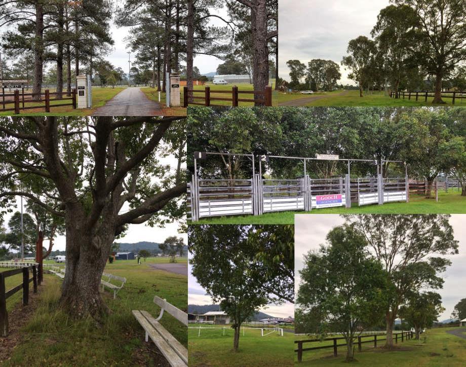
The original vegetation on the Reserve has been cleared and as such, habitat values are limited to a range of both native and introduced tree species of various age distributions, possibly planted with the prime objectives of creating shade for the many users and increasing overall Showground aesthetics. The following groupings are described:
• An attractive corridor of Pines aligns the entry road to the Showground. These trees have also been planted near the south-eastern section of the boundary of the main arena, and in several positions in the south-eastern corner of the Reserve.
• A range of Eucalypts are well established on other sections of the arena boundary, as well as scatterings at strategic positions across the Reserve. Brush Box also has been planted close to the northern section of the arena boundary fence.
8 Soil Landscapes of Central and Eastern NSW (State Government of NSW and Office of Environment and Heritage) www.environment.nsw.gov.au/eSpade2Webapp//
Plan of Management Bulahdelah Showground Page 21
• A thick and healthy establishment of native scrub species exists near and within the eastern boundary of the cattle holding yards.

• Groundcover across the Reserve is a well-established mix of grass species, suitable for the more intensive uses such as field sports and horse events. The growth of grasses on the playing fields in the north-eastern section, is particularly luxuriant.
Biodiversity
Under the LGA, Council has obligations for conservation issues as determined by the Biodiversity Conservation Act 2016, and the Fisheries Management Act 1994. The LEP and the respective 10.7(1) planning certificates contain no notation of any significant biodiversity issues present at the Reserve. There is no biodiversity certified land or biobanking agreement associated with this land as per the Biodiversity Conservation Act 2016. Council’s Tree Preservation Order and Tree Inventory contains no trees of significance, on this Reserve. Biodiversity value of the Reserve is limited, and generally follows the descriptions of existing vegetation both native and introduced, provided in 4.4 above.
Plan of Management Bulahdelah Showground Page 22
(Clockwise top left): A corridor of well-established Pines aligns the Showground entry; Eucalypts and Brush Box established outside the boundary of the main arena, northern section; scrub species established on the eastern edge of the holding yards; trees of various ages align the arena boundary, also located in single planting or small clusters across the Showground area.
Figure 7 – Vegetation and Habitat
5 THE SOCIAL ENVIRONMENT


Aboriginal Significance
Prior to the 1800s, Bulahdelah was Worimi land.
The Reserve does not contain any items listed in the LEP as being of known aboriginal archaeological sites, nor places of heritage significance.
A search of the Office of the Environment and Heritage AHIMS Web Services (Aboriginal Heritage Information Management System) did not reveal that:

• aboriginal sites are recorded in or near the location of the Reserve (200 m buffer).
• aboriginal places have been declared in or near the location of the Reserve (200 m buffer).
However, Bulahdelah Mountain (See cover photo), a prominent feature in sight lines from many positions in the Reserve, is listed as an Aboriginal Place under the National Parks and Wildlife Act 1974. Bulahdelah Mountain Aboriginal Place is of particular significance to Worimi people for the links associated with the area through traditional beliefs and culture. Maintenance of these sight lines is important to consider in any development of the north-eastern section of the site.
Heritage Significance
The Reserve does not contain any items listed in the LEP as being of heritage significance.
The Reserve does not contain any items listed on the State Heritage register.
Contemporary Significance
Bulahdelah became a timber town in the 19th century and mining commenced in the 20th century. The town developed around these industries.
The Reserve has been part of the development of Bulahdelah since it was first created in 1886 and has been part of the development of a strong community spirit within the town. The commencement of the Showground in 1922 provided the venue for the expression of the skills and achievements of a coastal, rural based culture, which has continued until the current times, now providing a multi-functional basis and community focus for community commitment, communication and relationships, wellbeing and health. The richness of this collective community achievement is well reflected symbolically within the Reserve lands (see Figure 8).
Such is the ongoing presence and value of this Reserve to the community, who continue to meet, compete, play and enjoy recreation within its bounds.
The current population of Bulahdelah is over 1500 people. Although the population is vibrant and demonstrating good growth, there is also the trend of an aging population. Issues for future management of the Reserve will require facilities which match and cater for new and emerging recreational needs of the younger population, as well as the uses of an aging population. A trend in recent years is the attractiveness of the Reserve and its activities to people who are prepared to travel large distances from
Plan of Management Bulahdelah Showground Page 23
their homes to experience a taste of rural life.
Plan of Management Bulahdelah Showground Page 24
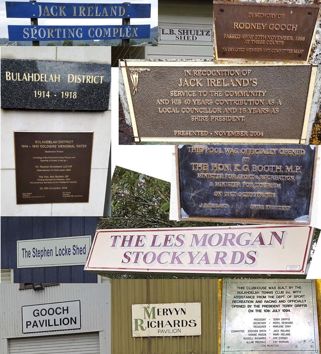
Symbolism of a strong community: acknowledgements to the tireless commitments of individuals at the Reserve, the War Memorial Gates and commemorative plaques.
Figure 8 – Contemporary Significance
6 CURRENT USES
The Reserve provides ready access to pedestrians and casual users as well as planned sporting events and practice and is well positioned to address the casual and active needs of the local community, as well as provide a linkage to other open space areas nearby.
Current User Groups
The current use of the land is for active open space by the following sporting bodies under agreement with Council in accordance with MidCoast Council’s Terms and Conditions for Use of Recreational Spaces procedures (March 2016):
Showground
• Bulahdelah Dressage Club
• Bulahdelah Pony Club
• Bulahdelah Agricultural & Horticultural Show
• Nissan Datsun Drivers Club - Annual hill climb and motor rally

Sportsfields
• Bulahdelah Football (Soccer) Club
• Bulahdelah Cricket Club
• Bulahdelah Central School
Swimming Pool
• Bulahdelah Swimming Club
• Bulahdelah Central School
• St Joseph’s Primary School
Tennis Courts
• Bulahdelah Tennis Club
Plan of Management Bulahdelah Showground Page 25
Other Uses
Opportunities exist for local residents and visitors who have ready access to the Reserve for a range of passive activities including:
• Public Swimming Pool, during warmer months.
• Motor home stays both informally and through motor home groups including Hunter Coastal Wanderers, Central Coast Wanderers, and Sydney Wanderers.

• Skateboarding.
• Walking, including dog walking and exercising.
Existing Interests and Tenures

Tenures are issued over community lands in accordance with MidCoast Council’s Leasing/Licensing of Council Lands and Buildings Policy (2017), and in accordance with the LGA (see 10.3).
There are no current tenures over the Reserve.
Plan of Management Bulahdelah Showground Page 26
7 RESERVE ASSESSMENT

Assessment of Infrastructure
The Reserve’s assets were inspected and recorded (see Figure 9). A preliminary assessment of asset condition is described in Table 2, complementing the MidCoast Council’s previously completed Conditions Report.9 The majority of the assets are in a good or very good condition reflecting the work of user groups and Council. Because of the number of assets involved, the approach was to segment the Reserve’s grounds into spatial activity clusters.
9 Council’s Conditions Report was undertaken by GHD (April 2017).
Plan of Management Bulahdelah Showground Page 27
SECTION ASSET Cond. SECTION ASSET Cond. Royce Dorney Arena Broadcasting box Lighting Fencing Seating - ring Arena surface Cattle yards Horse stalls Pony Club Store Bar ✓ ✓ ✓ ✓ ✓✓ ✓ ✓ Pavilions Mervyn Richards Pavilion Gooch Pavilion L.B. Shultz Shed ✓ ✓ ✓ ✓ ✓ ✓ Amenities Amenities Block Playing fields Stephen Locke Shed Playing surface Cricket pitch Cricket practice net Drainage Lighting ✓ ✓ ✓ ✓✓ ✓ Stage Stage Pavilion Sports Centre ✓ ✓ ✓ Tennis Clubhouse Courts Pagoda Lighting ✓ ✓ ✓ ✓ ✓ ✓ ✓ ✓ Swimming Admin / Entry Fence Pool Toddlers pool Amenities ✓ ✓ ✓ ✓ ✓ Other Main Entry Skatepark Camping/infrastructure Dump site Cattle stalls Boundary fencing Helipad ✓ ✓ ✓ ✓ ✓ ✓ ✓ ✓ ✓ ✓ ✓ ✓ ✓ Very Good ✓ Good (satisfactory) Poor Very Poor (unserviceable)
Table 2 – Condition of Land and Buildings
Plan of Management Bulahdelah Showground Page 28
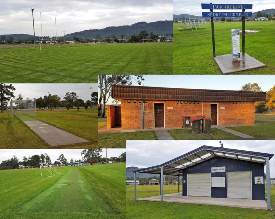
Figure 9 – Plan View - Assets of Bulahdelah Showground
Figures 10-14 depict a range of assets across the Reserve.


Plan of Management Bulahdelah Showground Page 29
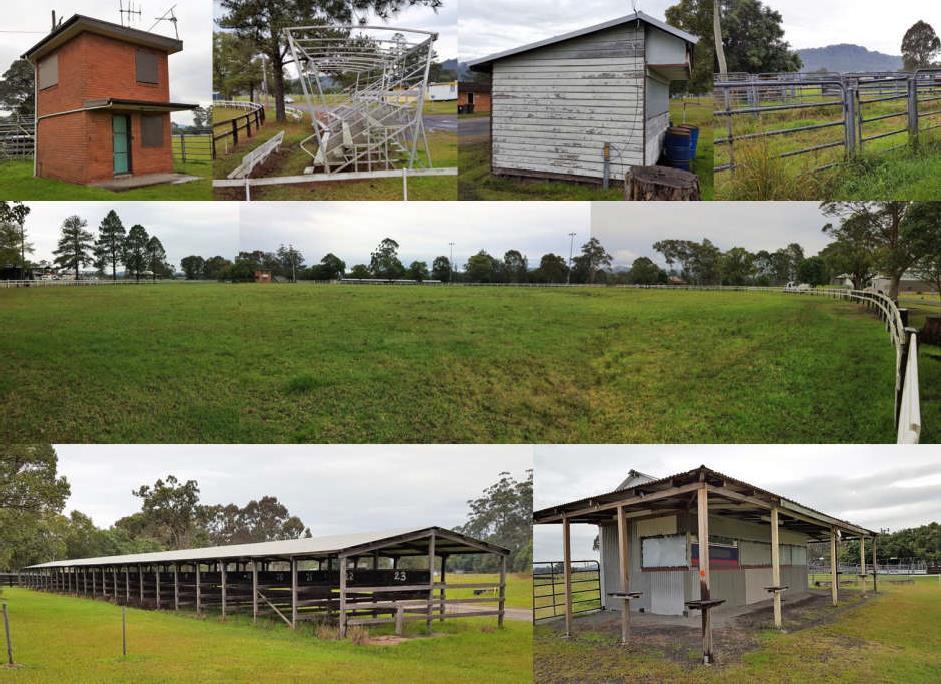
Clockwise top left: Broadcast box, seating, Pony Club store, cattle yards, Royce Dorney Arena surface and fencing, bar area, horse stalls.
Figure 10 – Assets of Bulahdelah Showground – Main Arena Area
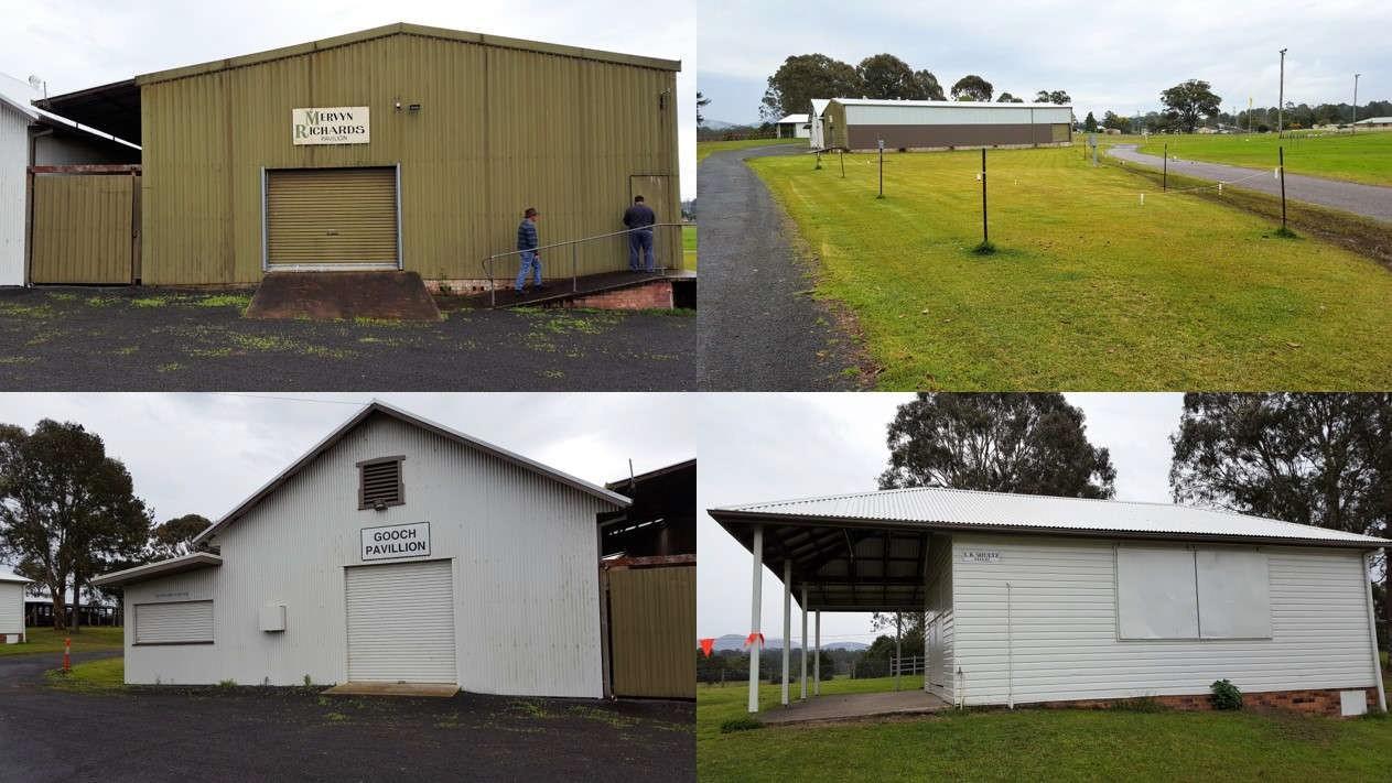
Figure 11 – Assets of Bulahdelah Showground - Pavilion Area
Clockwise (from top left): Mervyn Richards Pavilion, access roads to the pavilion area, L.B.Schulz Shed, Gooch Pavilion.

Plan of Management Bulahdelah Showground Page 30
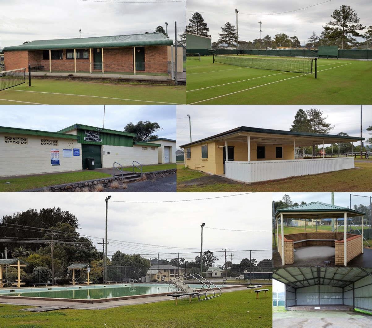
Clockwise (from top left): Playing surface, water supply, amenities block, the Stephen Locke Shed, cricket pitch, cricket practice nets.
Figure 12 – Assets of Bulahdelah Showground – Playing Fields Area

Plan of Management Bulahdelah Showground Page 31
Clockwise (from top left): Tennis clubhouse, tennis courts, Pavilion - Sports Centre, tennis area pagoda, stage, swimming pool, swimming pool entrance.
Figure 13 – Assets of Bulahdelah Showground – Tennis, Swimming and Stage areas
User Assessment

Prior to formal commencement of this Plan of Management, discussions with user groups at the Reserve were conducted and views on a range of issues were captured in a standard StrengthsWeaknesses-Opportunities-Threats (see Section 11 below for more information). A number of issues were acknowledged during this process which will impact on the success and sustainability of the Reserve into the future. Many of these will be addressed in the Action Plan (Section 13). They are:
• Control of Access: The internal roads of the site provide an alternate access from Stuart Street to Myall Street creating a safety and security issue.
• Co-ordination of Use: Usage of the Reserve needs to be coordinated and communicated to ensure there is no conflict. This is especially important when sporting events conflict with Major events or the use of the Reserve for Recreational vehicles.
• Communication: There is a lack of communication between users, the Tourist information Centre and Council.
• Lack of formal parking area: Lack of physical space particularly for larger vehicles, often using the space allocated to separate activities, causes problems especially when multiple events are

Plan of Management Bulahdelah Showground Page 32
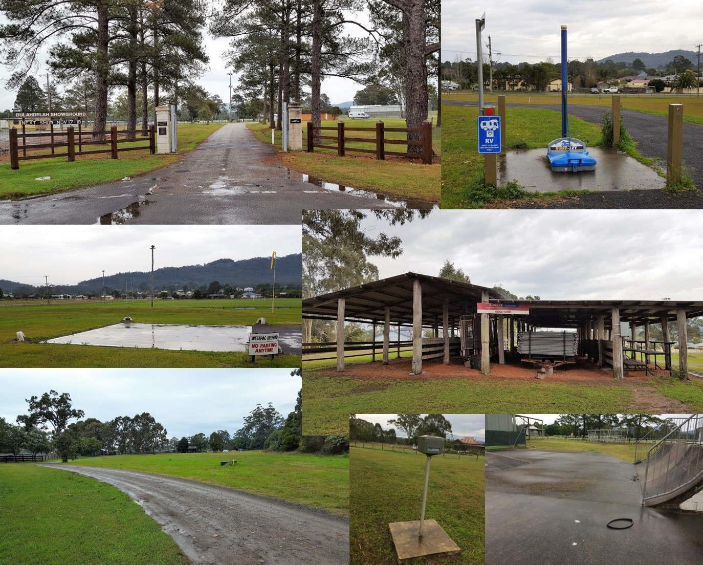
Clockwise (from top left): Main Entrance, RV dump site, cattle stalls, skate area, RV power service, extension of access track from Myall Street towards Jackson Street, helipad.
Figure 14 – Assets of Bulahdelah Showground - Other
being staged.
• Lighting: The capacity to supply power for lighting and other purposes during major or multiple events limits use potential.
• Current change amenities are poor: The change area for sports use is sub optimal and requires individual rather than group shower areas.
• Drainage issues: Drainage issues exist across the site including:
o Sportsfields - The drainage for the sportsfields is incomplete and requires:
▪ Herringbone drains on the eastern field
▪ Dish drain to the north of the western field
▪ Fixing the drains under the walkway adjacent to the shed which becomes blocked.
o Drainage around Jackson Street - the drainage, aligned with clay based soil, does not drain, and needs to be cleaned out.
o The main arena - Pony club days cancelled because of wet grounds.
• Fee collection is casual or non-existent: This is an important area of cash return requiring attention.
• Site usage – There is an opportunity, with the installation of better amenities away from the sports fields:
o to grow the RV business; and

o to attract other groups; and
o build on recreation for the aging population.
• Lack of Volunteers
Status Assessment
As part of the site investigation process it is apparent that the formation of the extension of Myall Street within the Reserve on the south-western boundary may create an issue of liability for Council as Crown Land Manager.
Plan of Management Bulahdelah Showground Page 33
PART B – THE PLAN
8 A VISION FOR THE LAND
Council recognises the significance of the Bulahdelah Showground to the local and regional community and envisages that the role of the Reserve is:
• To provide recreation and sporting facilities in line with current and emerging community needs.
• To provide a diverse range of activity opportunities and landscape settings to encourage healthy lifestyles and maximise opportunities for engagement in physical activity.
• To provide a safe, attractive venue with equitable and convenient access to recreation, sport and open space infrastructure.
• To ensure the spaces and facilities at the Reserve support the ongoing viability of community user groups and have capacity to adapt to changing needs over time.
• To maximise options for sustainability by capitalising on the interests of new potential users and visitors, in particular those from further afield.
• To maintain and improve environmental values where present.
The above visionary statements are developed from a number of sources, including:
• Council’s broad strategic intent in the management of its community land by the year 2030, which is summarised in the following two key directions:
o Embracing and Protecting our Natural Environment: Protecting the Natural Environment while addressing the challenges of population growth.
o Planning the Balance: Providing appropriate services and infrastructure, community facilities and opportunity for residents to continue to enjoy their existing lifestyle balanced with the impact of increases in population, additional development and influx of tourists.
• Further, from a scoping discussion with community Reserve users (conducted as part of this Plan development), three guiding and intrinsic values of this Reserve emerged:
o The Reserve is a significant asset for this community representing its primary sporting facility.
o The Reserve has been developed by and is “owned” by the local community and there is a strong recognition of the benefits in diversity of site use and concentration of activity provides for essential bonding and connectivity often across diverse interest groups.
o The Reserve represents an important opportunity in the economic development of the town being adjacent to the Pacific Highway and within the “three-hour travel window” from Sydney.
Plan of Management Bulahdelah Showground Page 34
This is consistent with Council’s Recreation and Open Space Strategy (ROSS) which acknowledges Bulahdelah Showground as a District Facility. This is principally around its use as a sporting facility. Development of amenities beyond a District Sporting Facility may be required where the Reserve is to be utilised to enhance economic development of the town. This is already the case with the placement of an RV dump site aimed at users well outside the District.
Plan of Management Bulahdelah Showground Page 35
9 OBJECTIVES, CLASSIFICATION AND CATEGORY OF LAND
The Reserve is classified as Community Land under the LGA as amended by the Local Government Amendment (Community Land Management) Act 1998
Under Section 36(4), all Community Land must be categorised as one of the following categories:
• Natural Area - (further categorised as either Bushland, Wetland, Escarpment, Foreshore, Watercourse)
• Sportsground
• Park
• Area of Cultural Significance; or
• General Community Use.
The Core Objectives for all community land categories vary according to the categorisation of the land. All objectives are defined in Section 36 (1) of the LGA and also appear in Appendix 1 of this PoM.
It is considered that in accordance with the guidelines set out in the Local Government (General) Regulation 2021 and Practice Note 1: Public Land Management (Department of Local Government Amended 2000), and consistent with respective core objectives, land at the Reserve should be categorised as:
• Sportsground
• General Community Use
Sportsground
Relevant Core Objectives for the management of land categorised as Sportsground are:
• to encourage, promote and facilitate recreational pursuits in the community involving organised and informal sporting activities and games, and

• to ensure that such activities are managed having regard to any adverse impact on nearby residences.
Description and Location
The Sportsground is the part of the Reserve where the organised competitive sporting activities are conducted. These include field sports (cricket, athletics, football and soccer), and main ring events including camp drafting. The Sportsground consists of the main arena, the sporting fields in the Reserve’s north-eastern section, and the tennis courts. It also includes those infrastructure items which provide immediate services to those activities such as the Stephen Locke Shed, the tennis club house,
Plan of Management Bulahdelah Showground Page 36
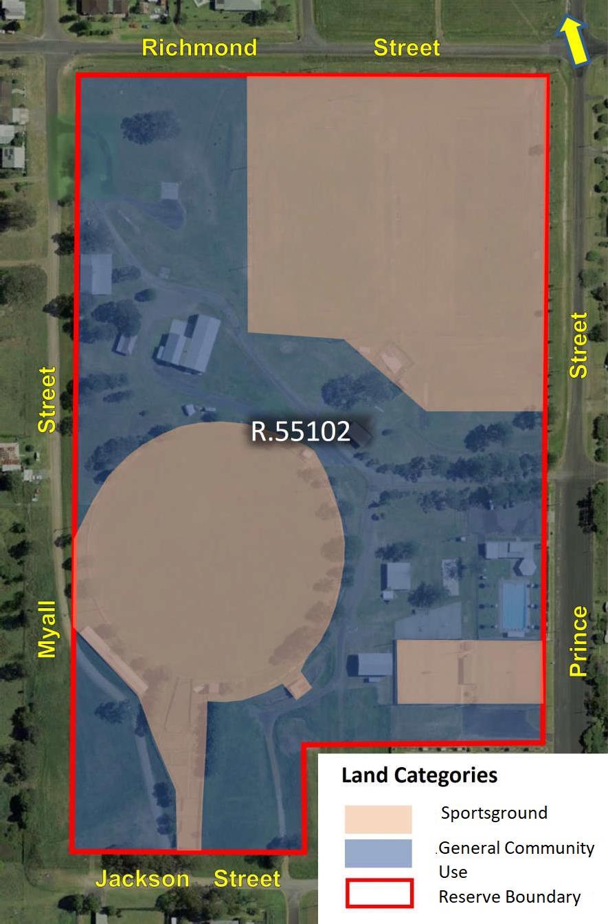
Figure 15 shows the location of land categories across the Reserve.
the broadcast box, the bar, the pony club store, lighting, seating, and adjacent yards which contain the event stock (eg., cattle yards and the horse stalls).
Plan of Management Bulahdelah Showground Page 37
Figure 15 – Land Categories
Management Objective
The area identified as Sportsground will be managed to maintain the current level of use by the established user groups such as the Bulahdelah Tennis, Football, Cricket, Dressage and Pony Clubs, Bulahdelah Central School and the Bulahdelah Agricultural & Horticultural Show.
The emergence of new sports or sporting events, and the increasing popularity of others, should be monitored and encouraged.
Ancillary facilities should be maintained at least to a level that will attract regular patronage, utilising the fees raised from Reserve users. In some cases, it is the intention that improvements to these facilities will be staged (eg., cricket practice areas, and new sporting surfaces for football and soccer).
Where present, environmental values will require management in accordance with policy and legislation.
General Community Use
Relevant Core Objectives for management of community land categorised as General Community Use are to promote, encourage and provide for the use of the land, and to provide facilities on the land, to meet the current and future needs of the local community and of the wider public:
• in relation to public recreation and the physical, cultural, social and intellectual welfare or development of individual members of the public, and

• in relation to purposes for which a lease, licence or other estate may be granted in respect of the land (other than the provision of public utilities and works associated with or ancillary to public utilities).
Description and Location
The General Community Use area has a strong multi-purpose function and meets the physical, cultural and intellectual needs of the community, whilst also attracting and supporting some activities which have a capacity for commercial return. This includes the various show pavilions and offices, the camping ground facilities and associated infrastructure, the swimming pool, the entries into the Reserve, the pavilions, the amenities blocks, markets and annual show entertainment stalls, walking areas, and casual use.
Management Objective
The area identified as General Community use will be managed to improve the health of the Bulahdelah community by encouraging free and unrestricted access for casual use including exercising (walking, swimming etc.,), and attracting and maintaining tenures to generate income from existing and opportunistic users such as markets, camping/caravaners and other commercial interests.
The growing of the businesses and their required infrastructure in this multi-functional area will be a priority (in particular the recreational touring business). There will be an ongoing need to also address issues associated with aging assets and infrastructure, in particular the pool, amenities and show pavilions. Current limitations to parking will be a constraint to continued and growing uses particularly during staging of multiple events and will require consideration in this Plan.
Plan of Management Bulahdelah Showground Page 38
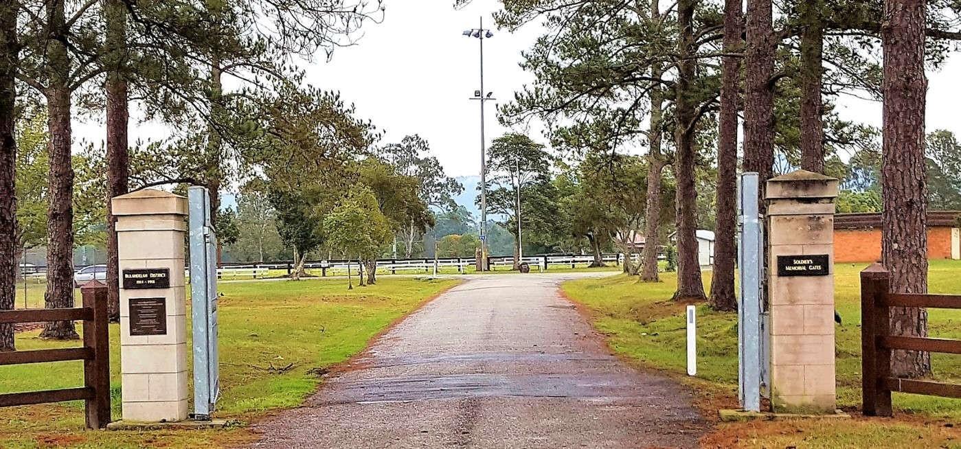
The General Community Use area should represent the “front-end” image and character of any multifunctional Reserve. The current memorial gates on the eastern boundary (see Figure 16) provide this function and should be appropriately maintained.
Where present, environmental values will require management in accordance with policy and legislation.
Plan of Management Bulahdelah Showground Page 39
Figure 16 – Bulahdelah Showground - Memorial Gates
10 MANAGEMENT AND DEVELOPMENT OF THE RESERVE
Reserve Management
Council reserves the right to control the use of the Community Land including Bulahdelah Showground.
Council intends to:
• Create opportunities for community consultation and participation in the planning and development of Community Land.
• Facilitate a system whereby enquiries and complaints10 from the public can be efficiently and promptly dealt with.

• Consider and attempt to balance the need for community recreation facilities with the impact development that such sites will have on local residents.
• Consider access to recreational facilities for all users.
• Ensure all formal use of the Reserve is authorised through appropriate documentation.
• Allow casual informal use consistent with Council’s policies and procedures.
• Consider how use of the site can provide funding for the maintenance of the facilities for the Reserve.
The Bulahdelah Showground Management Committee (BSMC)11 is an Asset Committee established by Council under Section 355 of the LGA
The BSMC will manage the Reserve consistent with this Plan. The role of the BSMC is:
• To undertake an advisory role in respect of the care, maintenance, repair, beautification, improvement and management of the Reserve. The BSMC shall liaise with Council through a Contact Officer or current Councillor representative/s on the Committee, in respect of proposed projects.
• To carry out works as approved by Council.
• In the event that the BSMC takes bookings for facility use, to maintain a record of bookings of the Reserve and its facilities in diary form and produce such a book for the inspection of Council on demand.
• To provide access to the Reserve and its facilities for use by citizens of and visitors to Bulahdelah without distinction.
• To allow any regular user of the Reserve to erect structures under such conditions as the BSMC
10 Complaints in relation to the Reserve will be addressed consistent with Council’s Complaints Management Policy.
11 In the event there is no Section 355 Committee Council will perform the role of the committee in this PoM.
Plan of Management Bulahdelah Showground Page 40
shall see fit, in accordance with this PoM, provided that no such agreement shall be concluded without the approval in writing of the Council, so that Council’s insurers are aware of the event activity.
• To ensure a copy of current rules of use of the Reserve and its facilities and the current schedule of fees and charges are exhibited in an appropriate public place at the Reserve.
• To recommend to Council the making of rules or setting of any fees and charges, none of which are to be implemented without formal approval by Council.
Permitted Uses and Activities
The Reserve allows free and unrestricted access for informal use when formal sporting activities and other formal activities are not being undertaken.
Permissible Uses
Table 3 lists the permissible uses on the Showground with their scale and intensity.
Table
Camping and caravanning12
physical constraints of the facility Agreement via tenure or hire agreement

Limited to the locations specified in the operating licence by Council
Canteens and Kiosks Limited to the hours the facility is booked. Agreement via tenure or hire agreement
Car parking
Casual playing of games or informal sporting activities
Children’s programs and events
Limited to the physical constraints of the facility and/or to the requirements of the activity
Limited to the physical constraints of the facility
Limited to the physical constraints of the facility and/or to the requirements of the activity
Operating hours of the establishment subject to Council approval
24 hours a day, 7 days a week subject to Hire Agreement
7 days a week, 8.00am –10.00pm
24 hours a day, 7 days a week
7 days a week, 8.00am –sunset
8.00am – 10.00 pm, 7 days a week subject to Tenure or Hire Agreement
12 This will be allowed only where approval to operate is obtained under the LGA. Short-term primitive camping is permissible, subject to approval by way of Council Resolution and having the required infrastructure in place.
Plan of Management Bulahdelah Showground Page 41
Use Scale Intensity Access roads Limited to the physical constraints of the facility and/or to the requirements of the activity 24 hours a day, 7 days a week Amenities Limited to the physical constraints of the facility and/or to the requirements of the activity 24 hours a day, 7 days a week Alternate energy technology Limited to the physical constraints of the facility 24 hours a day, 7 days a week Art and cultural classes and events Limited to the physical constraints of the facility and/or to the requirements of the activity 7 days a week, 8.00am –sunset Or up to 10.00pm at floodlit venues
to any Hire Agreement, Tenure and/or
Application conditions for a specific event Cafe Limited to
3 - Permissible Uses
Subject
Development
the
Plan of Management Bulahdelah Showground Page 42 Use Scale Intensity Community events (fundraising/charity events, special events) Limited to the hours the facility is booked. Agreement via tenure or hire agreement 7 days a week, 8.00am –10.00pm Community Services Limited to the physical constraints of the facility Agreement via tenure or hire agreement 24 hours a day, 7 days a week Dog training and exercise Limited to the physical constraints of the facility and/or to the requirements of the activity 7 days a week, sunrise - sunset Drainage and irrigation Limited to the physical constraints of the facility 24 hours a day, 7 days a week Education Services Limited to the physical constraints of the facility Agreement via tenure or hire agreement 24 hours a day, 7 days a week Emergency use Limited to the physical constraints of the facility and/or to the requirements of the activity 24 hours a day, 7 days a week Filming and photography (commercial, amateur) Limited to the physical constraints of the facility and/or to the requirements of the activity 24 hours a day, 7 days a week Subject to Tenure Fitness and wellbeing programs Limited to the physical constraints of the facility and/or to the requirements of the activity 7 days a week, sunrise - sunset Landscaping Limited to the physical constraints of the facility 24 hours a day, 7 days a week Licensed bar, bistro and café Limited to establishments with a liquor licence Operating hours of the establishment subject to Council approval Maintenance buildings Limited to the physical constraints of the facility 24 hours a day, 7 days a week Markets Limited to the physical constraints of the facility Operating hours subject to Tenure or Hire Agreement Mobile food vendors Limited to the physical constraints of the facility Operating hours subject to Tenure or Hire Agreement Organised sports competitions Limited to the physical constraints of the facility 7 days a week, 8.00am –10.00pm Organised sports training Limited to the physical constraints of the facility 7 days a week, 8.00am –10.00pm Outdoor film screening Limited to the physical constraints of the facility Operating hours subject to Tenure or Hire Agreement Passive recreation Limited to the physical constraints of the facility and/or to the requirements of the activity 7 days a week, sunrise –10.00pm Paths Limited to the physical constraints of the facility 24 hours a day, 7 days a week Personal training Non-exclusive use - up of 6- 18 people maximum 7 days a week, sunrise - sunset Playing of a musical instrument, or singing, for fee or reward Limited to the physical constraints of the facility Operating hours subject to Tenure or Hire Agreement Playing of games Limited to the physical constraints of the facility 8.00am – 10.00 pm, 7 days a week subject to Tenure or Hire Agreement Private events (i.e. weddings, birthdays) Limited to the physical constraints of the facility and/or to the requirements of the activity 7 days a week, 8.00am –sunset subject to Tenure or Hire Agreement Public performance or education Limited to the physical constraints of the facility and/or to the requirements of the activity 7 days a week, 10.00am –10.00pm subject to Tenure or Hire Agreement Public utility infrastructure Limited to the physical constraints of the facility 24 hours a day, 7 days a week Remediation works Subject to noise, workplace health and safety and relevant legislation 24 hours a day, 7 days a week School sport and recreation Limited to the physical constraints of the facility and/or to the requirements of the activity Monday – Friday 7.00am –4.00pm
Council at any time in the future, reserves the right to prohibit the taking or consumption of alcohol on this Reserve. This will be indicated by conspicuously displayed signs in accordance with Section 632 and Section 670 of the LGA
It is an express provision of this PoM that Council shall provide from time to time as circumstances may require the construction and maintenance of utility services, provision and maintenance of watercourses, floodways, cycle ways, (in accordance with s47f of the LGA) and the granting of easements (in accordance with s46 of the LGA).
Leases, Licences and other Estates
This PoM authorises leasing, licensing or granting of any other estate over this Reserve for any community purpose as determined by Council, consistent with the category and the purpose of the Reserve. Any agreement which may be entered will be in accordance with Section 45, 46, 46A, 47, 47AA & 48 of the LGA.
For this section please see the Explanation of Terms13 set out below.
The LGA provides that tenures (leases, licences, or any other estates) or easements may be granted over all or part of community land in accordance with Section 46.
Tenures may be held by:
13 Explanation of Terms
Tenure – A lease, licence or other estate issued by Council in accordance with Section 46 of the Local Government Act 1993 or Section 2.20 of the CLMA.
Hire Agreement – An estate issued by the Holder to the Hirer consistent with their Tenure.
Holder – The company, organisation, individual or group of individuals who have been issued with a Tenure.
Hirer - The company, organisation, individual or group of individuals who have been issued with a Hire Agreement.

Plan of Management Bulahdelah Showground Page 43 Use Scale Intensity Shade structures Limited to the physical constraints of the facility and/or to the requirements of the activity 24 hours a day, 7 days a week Showground maintenance Subject to noise, workplace health and safety and relevant legislation 24 hours a day, 7 days a week Sponsorship signage (temporary) As per section 24 hours a day, 7 days a week Storage facilities Limited to the physical constraints of the facility 24 hours a day, 7 days a week subject to Tenure or Hire Agreement Telecommunication facilities Subject to relevant legislation 24 hours a day, 7 days a week Temporary structures (i.e. marquees, tents, stages) Limited to the physical constraints of the facility Temporary structures (no pegs, weighted only) Youth programs and events Limited to the physical constraints of the facility and/or
the
of the activity 8.00am – 10.00 pm, 7 days a week subject to Tenure or Hire Agreement
to
requirements
• community organisations and sporting clubs, or
• by private/commercial organisations or
• individuals providing facilities and/or services for public use.
The maximum period for leases and licences on community land allowable under the LGA is 30 years (with the consent of the Minister for a period over 21 years) for purposes consistent with the categorisation and core objectives of the particular area of community land.
Community land may only be leased or licensed for periods of more than 5 years if public notice is given according to the requirements of Sections 47 and 47A of the LGA.
Leases
A lease will be generally required where exclusive use or control of all or part of community land is desirable for effective management. A lease may also be required when the scale of investment in facilities, the necessity for security measures, or where the relationship between a holder and facilities on community land justifies such security of tenure.
Leases issued by Council will require:
• That subleases or any other supplementary tenures can only be issued by the Holders only with the approval of Council, and consistent with Section 47C of the LGA.
• Maintenance of the facility will be the responsibility of the Lessees.
Licences
Licences allow multiple and non-exclusive use of an area. A licence may be required where intermittent or short-term use or control of all or part of the community land is proposed. A number of licences for different holders can apply to the same area at the same time, provided there is no conflict of interest.
Hire Agreements
An agreement for use of this Showground (Hire Agreement) may be issued by the DSMC for any purpose listed below, consistent with the Manual and subject to the approval of Council. A hire agreement may be issued to regular hire or a singular hirer for formal use. Any legal requirements as determined by Council will include the requirement for adequate public liability insurance cover.
Purposes for which Tenures may be issued
In accordance with Section 46A of the LGA, a Plan of Management for community land is to specify and authorise any purpose for which a lease, licence or other estate may be granted over community land during the life of a Plan of Management.
This Plan of Management authorises a Tenure to be issued:
• for any permissible use in Table 3.
• for purposes consistent with the Showground’s:
Plan of Management Bulahdelah Showground Page 44
▪ categorisation (see Sections 9.1 and 9.2), and
▪ zoning (see Section 3.1) under Section 46 of the LGA, and
▪ reserve purpose of Public Recreation and Showground as required under the CLMA
However, the CLMA allows that Council may also issue short term licences (for a period of less than one year) consistent with Section 2.20 of the CLMA. This section provides that licences may be issued, inconsistent with the reservation purpose, for prescribed purposes currently being:14
(a) access through a reserve,
(b) advertising,
(n) hiring of equipment,
(o) holiday accommodation,
(c) camping using a tent, caravan or (p) markets, otherwise,
(d) catering,
(e) community, training or education,
(q) meetings,
(r) military exercises,
(s) mooring of boats to wharves or other
(f) emergency occupation, structures,
(g) entertainment,
(h) environmental protection, conservation
(t) sales,
(u) shows, or restoration or environmental studies,
(i) equestrian events,
(v) site investigations,
(w) sporting and organised recreational
(j) exhibitions, activities,
(k) filming (as defined in the LGA),
(l) functions,
(m) grazing,
(x) stabling of horses,
(y) storage.
A tenure or hire agreement on Crown land may impact native title rights and interests. Any use agreement issued on Crown land must be issued in accordance with the future act provisions of the Native Title Act 1993 and in accordance with Part 8 of the CLMA unless native title is extinguished. For Crown land which is not excluded land this will require written advice from one of Council’s native title managers that it complies with any applicable provisions of the native title legislation.
Appendix
Plan of Management Bulahdelah Showground Page 45
14
2 presents the full description of all tenures available for community land within MidCoast Local Government Area, including leases and other tenures, casual and short term licences, and approved activities.
Crown Land Management Regulation 2018 - S.31.
Allocation
The Reserve will continue to be used by a variety of user groups and individuals for purposes previously noted. Council and the BSMC will endeavor to generate greater utilisation of the Reserve for recreation and other activities consistent with the Reserve purpose.
Primary Users and Specific Use
Use of the Reserve, for a single specific use, will be allocated by Council to a Primary User by way of a lease, licence or other estate (see 10.3) subject to the provisions of the LGA, and consistent with the Core objectives (as described in 9). This will allow the Primary User to appropriately plan for the development and maintenance of the facilities that have been constructed for that purpose.
While Council, with the support of the BSMC, will have a strong oversite role, everyday management of the facilities for that purpose, will be the role of the Primary User.
It is proposed in this PoM that the Bulahdelah Agricultural and Horticultural Committee be formally appointed as a Primary User, for the areas where it is a sole user, and that lease agreements be offered.
Shared Facility Use
Any part of the Reserve not subject to a lease, licence or other estate issued by Council will be managed by the BSMC. This will include those parts of the Reserve that are used by more than one user or those which are required for general community access.
The BSMC shall manage the use of shared facilities to both Regular Users15 and Casual Users in a fair and transparent manner.
Booking fees and rental will be utilised to contribute to the maintenance of the Reserve and facility upgrade and replacement.
Fees
Council applies fees for the use of Council reserves. A usage application must be lodged with the appointed BSMC prior to the event. All applicable fees must be paid prior to the hire/use of the Reserve.
The fees associated with the hiring of Council reserves for major events, concerts, functions etc. are detailed in Council’s Fees and Charges Schedule included on Council’s website. Council’s fee structure is reviewed on an annual basis.
Where the Reserve is to be hired for a purpose not within Council’s Fees and Charges Schedule, the fee will be set by the BSMC after approval from Council.
15 A Regular User is a group that utilises the Reserve on a planned and consistent basis. This may be for sporting games and training, markets, or shows. Note that a Primary User may also be a Regular User for those parts of the Reserve it does not hold a tenure over.


Plan of Management Bulahdelah Showground Page 46
Communication in the Management of the Reserve
Communication between Council, the BSMC, Primary Users, Regular Users and Casual Users is important to the success of this Plan. Council will establish and maintain clear lines of communication with the BSMC and across all Reserve users, especially relating to the operations of and responsibilities within a (proposed) business model. This will include:
• Restating terms of reference for operation of the appointed BSMC.
• Council to reveal and consolidate the new business model which includes a requirement that occupation, including that of Primary Users, is on the basis of formal agreement.
• In order to encourage better use of the Reserve, ensure the community and Primary Users are aware of the revised expectations regarding free and unrestricted access for casual uses to the General Community Use area.
The composition of the BSMC16 will be structured so Regular Users will have a voice in the Reserve Management. The inclusion of a Councillor on the BSMC will be an ongoing fundamental linchpin. However, at least in the initial stages of the PoM, the appointment of the Council Contact Officer, an ex-officio Council Officer is also important.
BSMC meetings will provide the formal vehicle between Regular Users of the Reserve.
The BSMC will be responsible for ensuring Casual Users are aware of their rights and responsibilities in utilising the Reserve.
Easements

Council reserves the right to grant easements as required for utilities and access (in accordance with s46 and s47f of the LGA), bearing in mind the impact of such easements on the site.
The granting of easements over Crown land will be subject to the provisions of the Native Title Act 1993 and Division 8.7 of the CLMA.
Development of New and Improvement of Existing Facilities
Council approval is required prior to any development or improvement made to Community Land.
All major developments and improvements to be funded (solely or partially) by Council will be subject to Council approval.
16 The BSMC membership should generally reflect the community organisations which utilise the Reserve and must be open to representatives of user groups and interested community members. Equal representation of each user group is recommended.
The Committee shall generally consist of:
• One (1) member of each organisation which is granted use of any portion of the facilities on a license, annual, seasonal or longer-term basis.


• A number of community representatives as detailed in the committee constitution.
• Councillor representatives appointed by Council annually in September.
Plan of Management Bulahdelah Showground Page 47
Council will encourage community assistance in the development of new facilities as well as maintenance of existing facilities through the co-operation and assistance of local groups.
Future improvements to the Reserve (see Figure 17) are to include:
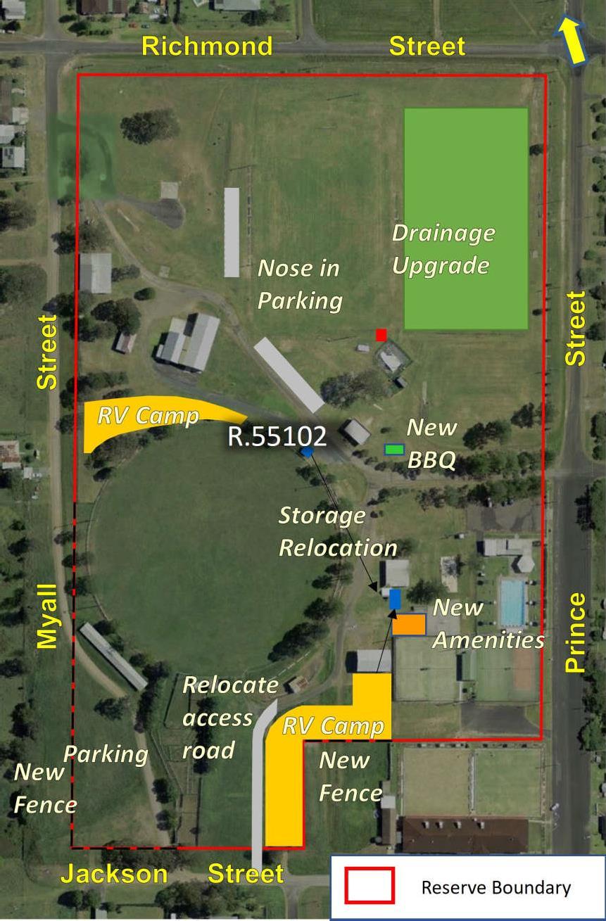
Plan of Management Bulahdelah Showground Page 48
Figure 17 – Planned Improvements
• Create an undersurface drainage system for the eastern sportsfield.
• Upgrade the drainage pipe under the path from the Stephen Locke Shed to the playing fields.
• Dismantle existing Pony Club storage shed and construct new facility adjacent to the existing Pavilion Sports Centre adequate to service various user groups and remove existing containers.
• Construct a new Amenities block to service RV users, Netball Court users and Main Arena users.
• Update the existing Amenities block.
• Relocate access track and gateway (to west of existing access) from Jackson Street boundary to permit full usage of Primitive / RV Camp area. Access to also permit vehicular access to adjoining Bowling Club parking/camping area.
• Fence (approx. 50m) along the northern boundary with the Bowling Club of the Reserve and place boundary markers along the north-south boundary of the Bowling Club (marker points or bollards) which will identify boundary at that point, but also permit through flow and turning of longer vehicles for positioning.
• Fence the open boundary section along southern end of Myall Street and western end of Jackson Street with a suitably placed gate to allow large vehicle access from Myall Street during peak usage times. Establish overflow parking area.
• Obtain development consent for short-term Primitive / RV Camp areas for approximately 21 sites in existing area and along the south-eastern boundary of the Reserve.
• At Prince Street entry, install suitable signage to divert RVs around northern reserve boundary to access Dump-Site from Myall Street to avoid unnecessary traffic crossing reserve.
• Construct nose-in parking area adjacent to the western sporting field.
• Remove existing skate park facilities and relocate to Mountain Park.
• Construct new BBQ facilities at sportsfield close to existing amenities.
• Install a flood warning system.
• Investigate the feasibility of a covered equestrian area, for multiple horse sports.
Where it is proposed to construct or establish a public work17 on reserved or dedicated Crown land,
17 A pubic work is defined as:
(a) any of the following that is constructed or established by or on behalf of the Crown, or a local government body or other statutory authority of the Crown, in any of its capacities:
(i) a building, or other structure (including a memorial), that is a fixture; or
(ii) a road, railway or bridge; or
(iia) where the expression is used in or for the purposes of Division 2 or 2A of Part 2 a stock-route; or
(iii) a well, or bore, for obtaining water; or
(iv) any major earthworks; or
(b) a building that is constructed with the authority of the Crown, other than on a lease.
Major earthworks are defined as:
Plan of Management Bulahdelah Showground Page 49
earthworks (other than in the course of mining) whose construction causes major disturbance to the land, or to the bed or subsoil under waters.
Plan of Management Bulahdelah Showground Page 50
where native title is not extinguished, prior to approval Council will notify and give an opportunity for comment from any representative Aboriginal/Torres Strait Islander bodies, registered native title bodies corporate and registered native title claimants in relation to the land or waters covered by the reservation or lease as required under the Native Title Act 1993.
Where a proposed update of a Park Master Plan, Capital Works Program, Sportsground Action Plan, Sports Facilities Asset Management Plan or any other plan is the approving documentation for a public work on Crown land, that approval will not be given unless the requirements of the Native Title Act 1993 have been addressed including the notification and opportunity to comment noted above.
Any development must comply with the scheme contained in the National Parks and Wildlife Act 1974 for the protection of Aboriginal cultural heritage.
Maintenance of Existing Facilities
Council will ensure the facilities on the Reserve are maintained to an appropriate standard. It intends to:
• Maintain the structures and open spaces on the Reserve in accordance with Council’s Asset Management Plan to measured targets within available resources.
• Continue to monitor the condition of structures on the Reserve and ensure effective maintenance procedures are in place through tenure conditions and Section 355 committee maintenance responsibilities.

• Prepare a safety audit of the site and repair or replace any areas that may impact on public safety.
• Continue to effectively administer Council’s seasonal policy of park occupation policy (MidCoast Council Terms & Conditions for use of Recreational Spaces Procedure 2016) with the prime users of the Reserve’s sportsground and general community use areas.
• Encourage community groups to assist with maintenance of whole of Reserve, particularly through appropriate signage. Note that appropriate signage is an important on-site management tool to avoid inappropriate usage, conflicts, and reduce safety concerns especially regarding movement of vehicles and animals in peak usage times.
• In conjunction with signage, use temporary barriers (ribbon fences, star pickets, single string markers etc) to direct and assist flow of traffic and appropriate occupation during peak use times.
• Ensure appropriate management of playing surfaces on all vegetated sportsgrounds (excludes rodeo arena, responsibility of primary user) including mowing at suitable time intervals.
• Ensure the efficient and conservative use of water, pesticides, herbicides and fertilisers across the Reserve, where required.
• Ensure regular collection of rubbish and elevate compliance activities against illegal dumping of rubbish.
• Council officers to continue monitoring for issues of compliance and general site amenity.
Plan of Management Bulahdelah Showground Page 51
• Maintain existing drainage systems across the Reserve to minimise impact of flooding and waterlogging.
Signage
Council uses signs to regulate the activities carried out on Community Land and to provide educational information so as to provide a safe and enjoyable place for passive and active recreational pursuits.
Whilst signs are a crucial source of information, they have a significant impact on the aesthetics of a Reserve. All signs must meet a design standard and be approved by Council. All signs must be sympathetic to their environment in their design, construction and location.
Council uses the Statewide Mutual Best Practice Manual – Signs as Remote Supervision for design of safety signage.
All signage must be placed in accordance with State Environmental Planning Policy No 64 – Advertising and Signage or State Environmental Planning Policy (Exempt and Complying Development Codes) 2008. Signage must also be consistent with the Great Lakes Development Control Plan.
Where a sign requires development consent, Council must approve as owner the lodging of a Development Application prior to assessment by Council in accordance with Schedule 1 Assessment Criteria of SEPP No 64.
Where a sign does not require development consent, Council must approve the sign before erection.
All Council signs erected under Section 632 of the LGA, plus Reserve name signs and traffic and safety signs, are permissible.
Proposed Signage
Council will ensure the following signage is on the Reserve:
• Descriptive signage featured on suitable entrance area.
• Directional signage for the purposes of guiding the community to required infrastructure and services.
• Signage for safety purposes including speed limitations and evacuation procedures.

Plan of Management Bulahdelah Showground Page 52
11 FINANCIAL SUSTAINABILITY
Funding Options
A major challenge in the future management of the Reserve, will be to generate income to address increasing costs associated with critical maintenance and new developments, and ongoing activities.
Income may be sourced from the following:
• Council’s General Revenue Fund (in accordance with annual operational budgets): Where the Reserve is being used for informal casual use, Council will contribute to the maintenance and development of Infrastructure.
• Section 94 Contributions specifically collected for community land: This component occurs as rate payer’s contributions for the general use of community land for community well-being.
• User pays for minor infrastructure works associated with some sporting facilities: This occurs through fund raising by the relevant body including memberships, minor sales and raffles etc., and aims at achieving tailoring surrounds and layout which suit and are compatible with the event or activity.
• Community contributions by way of community group projects (eg., Landcare, Rotary, Lions Club): This occurs through grants either sourced externally, and/or contributed locally by the group (eg., for the purposes of environmental works, social and intellectual well-being etc).
• Grant and loan funding from either Commonwealth or State Governments: The implementation of the management structure will allow Primary users to apply for funds from a number of Government bodies with the concurrence of Council. Council may also apply for these funds. A limited number of funding opportunities exist from government programs.
Division 12.5 of the CLMA provides for the Crown Reserve Improvement Fund18 (CRIF). Section 12.29 provides that:

(1) The following may be paid from the Crown Reserves Improvement Fund:
(a) the cost of the purchase or acquisition of land required for Crown reserves,
(b) the cost of the maintenance, improvement or development of Crown reserves (whether by direct expenditure or by grants, loans or advances to the managers of the Crown reserves), but only if the payment is made with the approval of the Minister…
Competitive Applications to receive funding from the CRIF are called for on an annual basis early each year by the DPE-CL. Further information about this process can be found at DPE-CL’s website at www.industry.nsw.gov.au/lands.
• Income from commercial operations: Where tenures are involved, income will arise as per details in the revenue-split in the corresponding agreement. Less formally, income may result from casual occupation, such as Reserve use fees, including those associated with camping and
Plan of Management Bulahdelah Showground Page 53
18 The Crown Reserve Improvement Fund is the successor to the former Public Reserve Management Fund created under the former Public Reserves Management Fund Act 1987.
motor home visits (see 13.2 below).

In order to address the outstanding and future maintenance requirements at this Reserve, and permit any required new developments as proposed in this PoM, it is important that all income which is generated from the Reserve be returned to the Reserve, and that this should be clearly demonstrated in the financial statements of the 355 Committee. Ensuring appropriate rental and fees for formal use of the site will assist in the maintenance of specialised infrastructure.
Emerging Opportunities to Increase Income
Council records indicate the Reserve is running at an annual financial loss, which requires consideration of new and emerging opportunities to grow site utilisation and income. The SWOT exercise and subsequent investigation identified opportunities in the growth of Camping and Recreational Vehicle use, sportsground growth and passive recreation.
Camping and Recreational Vehicles
This is an activity not formally approved for this Reserve. Development of Camping facilities would require approval under the Environmental Planning and Assessment Act 1979. However, it continues to represent an opportunity to take advantage of current growth in that market, without impacting on existing uses and existing businesses. Short-term primitive camping is permissible, subject to approval by way of Council Resolution and having the required infrastructure in place.
Council may be able to create a capacity for the Reserve to around 21 sites (with a primitive camp ground approval in accordance with the Local Government (Manufactured Home Estates, Caravan Parks, Camping Grounds and Moveable Dwellings) Regulation 2021 given the Reserve area of around 10.65 Ha
This would take advantage of existing and proposed infrastructure upgrades including:
• Upgrading of amenities as currently proposed.
• The RV Dump point.
• The Swimming facilities. The opening hours of the pool may need to be adjusted to suit Camp users and to facilitate fee collection.
Consideration of the placement of BBQ facilities and a play area that may double for community events and RV users may also increase site usage.
Council may also increase activity at the site for larger groups by having proforma applications available for event organisers to submit single event applications.
Attracting New Visitors and Users
Although this Reserve already performs strongly in this regard, there is a growing market in city-based communities who are prepared to travel to enjoy “the bush” and all it has to offer recreationally and socially, in particular, those that typify rural Australia. The “three-hour travel window” from the main centres of population (Sydney, Newcastle areas) places Bulahdelah in a strong strategic position to develop this market.
Plan of Management Bulahdelah Showground Page 54
The Reserve’s capacity to grow that market will be, as noted above, dependent on its area and infrastructure. However, the upgrading proposed, the surrounding environment and the proximity to the Myall River may make the Reserve a good site for the festival growth industry. Utilising the launching facilities currently available, 200 metres from the Reserve, at the end of Myall Street may provide an opportunity to link and grow patronage and enhance the local economy.
Plan of Management Bulahdelah Showground Page 55
IMPLEMENTATION PLAN
Table 4 sets out a number of actions required to implement the identified Management Strategies and Performance Targets within the Showground. These actions are the means of achieving the objectives of the PoM.
A clear indication of how the completion of the aims will be assessed is also provided in the Table under Performance Evaluation.
Performance Evaluation (how they will be assessed)
SPORTSGROUND
To encourage, promote and facilitate recreational pursuits in the community involving organised and informal sporting activities and games.
Complete works in accordance with approved Operational Plans.
Capitalise on good relationships with district sporting bodies currently using the sportsground, and on opportunities with outside bodies, ensuring greater use of the sportsground.
Continue to maintain the oval surfaces and associated infrastructure in accordance with appropriate agronomic practices and standards.
i. Upgrade the subsoil drainage under the eastern sports field.
ii. Upgrade the drainage pipe under the access path to the sportsfield to prevent blockages.
iii. Ensure appropriate, all weather vehicular access way to sporting fields for ambulance availability.
iv. Remove existing Pony club storage shed.
v. Assess and make appropriate upgrade to Horse stalls.
vi. Consider constructing multisport facilities where possible.
vii. Continue to effectively administer Council’s seasonal policy of park occupation (MidCoast Council Terms & Conditions for use of Recreational Spaces Procedure 2016) with users of the site’s sportsground.
viii. Ensure appropriate management of playing surfaces on all vegetated sportsgrounds (excludes rodeo arena, responsibility of primary user) including mowing at suitable time intervals.
ix. Encourage a positive relationship with the BSMC and users through the establishment of clear expectations, and communications.
x. Establish appropriate tenure and usage arrangements for existing and new users, at recommended/appropriate rent and hire fees.
xi. Encourage sporting clubs and organisations to actively participate in the maintenance of the facilities they use, as per agreement.
xii. Where necessary, develop guidelines to clarify and strengthen the requirement for sporting clubs to maintain orderly and tidy surrounds at all times.
xiii. Maintain sporting field surfaces using sound principles of fertiliser use, aeration
• Sportsground enjoys increase in usage by catchment area residents and beyond.
• Sportsground is used to capacity for organised sporting events.
• Grounds are managed in accordance with prescribed Council standards.
• Where possible, sportsground is catering for emerging trends and needs in organised sports.
• All feedback from user groups/sporting bodies to BSMC and Council is positive.
Plan of Management Bulahdelah Showground MidCoast Council Page 56 12
Table 4 - Implementation Table Management Objectives Management Strategies Actions
Management Objectives Management Strategies Actions
and topdressing as required.
xiv. Maintain oval fences.
xv. Undertake regular (at least annual) condition inspections and reports of all structures and ensure they are maintained to a district standard.
xvi. Ensure bins are provided and routinely removed.
xvii. Ensure that the requirements of any lease or usage agreement are met.
xviii. BSMC to proactively attract new activities and sports to the Sportsground by promoting the facility through Council papers and media.
xix. Regular inspections by Council officers.
Performance Evaluation (how they will be assessed)
xx. Signage in accordance with Schedule 1 SEPP 64 and approved by Council. To ensure that such activities are managed having regard to any adverse impact on nearby residences.
GENERAL
COMMUNITY USE
To promote, encourage and provide for the use of the land, and to provide facilities on the land, to meet the current and future needs of the local community and of the wider public:
• in relation to public recreation and the physical, cultural and intellectual welfare or development of individual members of the public.
Build and maintain good rapport with neighbourhood.
xxi. Collate and assess all complaints from neighbours concerning traffic, noise from events, crowd behavior etc., and respond accordingly.
xxii. Council to communicate with residential areas immediately close by, on a needs basis, especially regarding major events.
xxiii. Regular inspections by Council officers.
• Numbers of positive responses and complaints from sporting bodies, and residents.
• Manage existing assets into the future through appropriate assessment and planning.
• Complete necessary works in accordance with approved Operational Plans.
• Enable and promote free and unconstrained access to casual users of the area categorised General
i. Upgrade existing amenities and change rooms.
ii. Construct new amenities block (male, female) and construct new facility adequate for use for major events and for regular camping use.
iii. Construct nose-in parking area facing the western sportsfield.
iv. Obtain development consent for an, up to 21 site Primitive Camp area to facilitate authorisation of RV and camping on the Reserve.
v. Extend RV usage to the south-eastern boundary of the Reserve and address additional infrastructure needs to service camper area (power boxes).
vi. Relocate southern access track to west of existing, to permit full use of area for camping.
vii. Construct a BBQ facility at sportsfield close to existing amenities.
viii. Construct new storage facility to facilitate removal of the Pony Club store and storage container on the site.
ix. Install improved electricity power distribution system for entire site.
x. Remove existing skate park facility.
xi. Fence and gate the south-western boundary of the site, establishing overflowparking in that area.
• All new and maintenance works are completed in accordance with works plans.
• General Community Use area has attracted new commercial users.
• Community enjoying unfettered access for casual use of new recreational facilities.
• Primary and other users are content with tenuring arrangements and business plan is working well with all, including clarity and communication.
• Grounds are kept tidy and
Plan of Management Bulahdelah Showground MidCoast Council Page 57
Management Objectives Management Strategies Actions
Community Use. xii. Fence the east-west boundary of the site from the Bowling club.
xiii. Install boundary markers (posts or bollards) along western (north-south) boundary with Bowling Club to identify camping occupation positions and allow through-flow and positioning of longer vehicles.
xiv. Maintain the structures and open spaces on the Reserve in accordance with Council’s Asset Management Plan to measured targets within available resources.
xv. Implement a safety audit of the site and repair or replace any areas that may impact on public safety.
xvi. Encourage community groups to assist with maintenance of whole of site, particularly through appropriate signage.
xvii. Ensure appropriate slashing/mowing of all grounds in the General Community Use area.
xviii. Ensure the efficient and conservative use of water, pesticides, herbicides and fertilisers across the Reserve, where required.
xix. Ensure regular collection of rubbish and elevate compliance activities against illegal dumping of rubbish.
xx. Council officers to continue monitoring for issues of compliance and general Reserve state.
xxi. Maintain existing drainage systems across the Reserve to minimise impact of flooding and waterlogging.
xxii. Install flood warning system particularly around appropriate signage and telemetry with trigger point.
xxiii. Undertake a safety review for the Reserve.
xxiv. In order to effectively manage on-ground usage (traffic flow, especially during peak usage vehicle, animal and people movement and use), and address safety concerns etc), erect signage in accordance with Schedule 1 SEPP 64 and approved by Council.
xxv. In conjunction with signage, use temporary barriers (ribbon fences, star pickets, single string markers etc) to direct and assist flow of traffic and appropriate occupation during peak use times.
xxvi. Install suitable signage at Prince Street entry to divert RVs around northern reserve boundary to access Dump-Site from Myall Street.
xxvii. Implement proposed management structure and communications strategy.
xxviii. Actively promote the recognition of significant contribution to the Reserve and
Performance Evaluation (how they will be assessed)
orderly.
• All feedback from Reserve users to BSMC and Council is positive.
Plan of Management Bulahdelah Showground MidCoast Council Page 58
Management Objectives Management Strategies Actions
the Town from the whole of the community focusing on the contribution of women and minority groups.
xxix. Manage the Camping area in accordance with the approval under Section 68 of the LGA
Performance Evaluation (how they will be assessed)
• in relation to purposes for which a lease, licence or other estate may be granted in respect of the land.
• Build on relationships with existing and new users of the various facilities in order to draw more people to the area categorised General Community Use both as casual and paying users.
xxx. Establish appropriate tenure arrangements for existing and new users, at recommended/appropriate rent and hire fees.
xxxi. Continue to effectively administer Council’s policy of park occupation (MidCoast Council Terms & Conditions for use of Recreational Spaces Procedure 2016) with users of the Reserve’s General Community Use areas.
xxxii. Implement additional infrastructure (eg., power, amenities) to allow camping/caravan area to operate to capacity.
xxxiii. Encourage a positive relationship with the BSMC and Primary Users and the establishment of clear communications and expectations.
xxxiv. Continue to monitor the condition of structures on the Reserve and ensure effective maintenance procedures are in place through tenure conditions and Section 355 committee (BSMC) maintenance responsibilities.
xxxv. Continue to implement Council’s Community Markets Policy.
xxxvi. Explore opportunities to utilise the Reserve’s proximity to the Myall river launching infrastructure to encourage water sports to the area.
• MidCoast Council Terms and Conditions policy effective.
• All tenures operating satisfactorily.
Plan of Management Bulahdelah Showground MidCoast Council Page 59
13 CONSULTATION DURING THE PREPARATION OF THIS PLAN
Community consultation is an important source of information necessary to provide an effective Plan of Management for Community Land and is a requirement under Section 38 of the LGA. MidCoast Council’s Community Engagement Policy, (adopted in 2017) outlines the principles and activities within the participating community which guide Council’s decision-making processes. Such participation creates the opportunity for interested parties to become actively involved in the development of a plan which reflects the needs, opinions and priorities of people using the Reserve.
Prior to formal commencement of this Plan of Management, discussions with all user groups at the Bulahdelah Showground were conducted and views on a range of issues were captured in a standard Strengths-Weaknesses-Opportunities-Threats (SWOT) format. Users were also asked to compile prioritised needs and aspirations for the Reserve.
The outcomes of the SWOT analysis appear in Appendix 3.
Council will undertake further consultation in accordance with its Communication and Consultation Strategy and as required under the act.
This PoM was placed on public exhibition from 7 October – 20 November 2022, in accordance with the requirements of section 38 of the LGA. A total of 13 submissions were received. Council considered these submissions before adopting the PoM. In accordance with section 39 of the LGA, prior to being placed on public exhibition, the draft PoM was referred to the Department of Planning and Environment – Crown Lands, as representative of the State of New South Wales, which is the owner of the Reserve. Council has included in the plan any provisions that have been required by the Department of Planning and Environment – Crown Lands.
In accordance with Section 70B of the Crown Land Management Regulation 2018 Council will obtain consent of the Minister administering the CLMA prior to adopting this PoM (see Appendix 5).
Plan of Management Bulahdelah Showground MidCoast Council Page 60
1. Core Objectives for Categories of Community Land
2. Leases, Licences and Development of Community Land – MidCoast Council (truncated)
3. Bulahdelah Showground, User Group Consultations
4. State Environmental Planning Policies which are relevant to the Buladelah Showground
5. Key steps in preparing the first PoM for Crown Reserves.
Plan of Management Bulahdelah Showground MidCoast Council Page 61
14 APPENDICES
15 REFERENCES
Biodiversity Conservation Act 2016: http://www.legislation.nsw.gov.au/
Community Land Management Plan 2012: Great Lakes Council.
Crown Land Management Act 2016: http://www.legislation.nsw.gov.au/
Department of Local Government 2000: Practice Note No.1, Public Land Management, Amended May 2000.
Espade; Office of Environment and Heritage: www.environment.nsw.gov.au/eSpade2Webapp//
Local Environmental Plan 2014: Great Lakes Council.
Local Government Act, 1993: Amended by the Local Government (Community Land Amendment) Act 1998. NSW Government: http://www.legislation.nsw.gov.au/
Recreation and Open Space Strategy 2006: Great Lakes Council.
Terms and Conditions for Use of Recreational Spaces 2016: MidCoast Council.
Weed Control Order 2014: Noxious Weeds Act 1993: http://www.legislation.nsw.gov.au/
Plan of Management Bulahdelah Showground MidCoast Council Page 62
CORE OBJECTIVES FOR CATEGORIES OF COMMUNITY LAND (Local Government Act 1993):
36E Core objectives for management of community land categorised as a natural area
The core objectives for management of community land categorised as a natural area are:
(a) to conserve biodiversity and maintain ecosystem function in respect of the land, or the feature or habitat in respect of which the land is categorised as a natural area, and
(b) to maintain the land, or that feature or habitat, in its natural state and setting, and
(c) to provide for the restoration and regeneration of the land, and
(d) to provide for community use of and access to the land in such a manner as will minimise and mitigate any disturbance caused by human intrusion, and
(e) to assist in and facilitate the implementation of any provisions restricting the use and management of the land that are set out in a recovery plan or threat abatement plan prepared under the Biodiversity Conservation Act 2016 or the Fisheries Management Act 1994.
36F Core objectives for management of community land categorised as a sportsground
The core objectives for management of community land categorised as a sportsground are:
(a) to encourage, promote and facilitate recreational pursuits in the community involving organised and informal sporting activities and games, and
(b) to ensure that such activities are managed having regard to any adverse impact on nearby residences.
36G Core objectives for management of community land categorised as a park
The core objectives for management of community land categorised as a park are:
(a) to encourage, promote and facilitate recreational, cultural, social and educational pastimes and activities, and
(b) to provide for passive recreational activities or pastimes and for the casual playing of games, and
(c) to improve the land in such a way as to promote and facilitate its use to achieve the other core objectives for its management.
36H Core objectives for management of community land categorised as an area of cultural significance
(1) The core objectives for management of community land categorised as an area of cultural significance are to retain and enhance the cultural significance of the area (namely its Aboriginal, aesthetic, archaeological, historical, technical or research or social significance) for past, present or future generations by the active use of conservation methods.
(2) Those conservation methods may include any or all of the following methods:
(a) the continuous protective care and maintenance of the physical material of the land or of the context and setting of the area of cultural significance.
(b) the restoration of the land, that is, the returning of the existing physical material of the land
Plan of Management Bulahdelah Showground Appendix 1
to a known earlier state by removing accretions or by reassembling existing components without the introduction of new material.
(c) the reconstruction of the land, that is, the returning of the land as nearly as possible to a known earlier state.
(d) the adaptive reuse of the land, that is, the enhancement or reinforcement of the cultural significance of the land by the introduction of sympathetic alterations or additions to allow compatible uses (that is, uses that involve no changes to the cultural significance of the physical material of the area, or uses that involve changes that are substantially reversible or changes that require a minimum impact).
(e) the preservation of the land, that is, the maintenance of the physical material of the land in its existing state and the retardation of deterioration of the land.
(3) A reference in subsection (2) to land includes a reference to any buildings erected on the land.
36I Core objectives for management of community land categorised as general community use
The core objectives for management of community land categorised as general community use are to promote, encourage and provide for the use of the land, and to provide facilities on the land, to meet the current and future needs of the local community and of the wider public:
(a) in relation to public recreation and the physical, cultural, social and intellectual welfare or development of individual members of the public, and
(b) in relation to purposes for which a lease, licence or other estate may be granted in respect of the land (other than the provision of public utilities and works associated with or ancillary to public utilities).
36J Core objectives for management of community land categorised as bushland
The core objectives for management of community land categorised as bushland are:
(a) to ensure the ongoing ecological viability of the land by protecting the ecological biodiversity and habitat values of the land, the flora and fauna (including invertebrates, fungi and micro-organisms) of the land and other ecological values of the land, and
(b) to protect the aesthetic, heritage, recreational, educational and scientific values of the land, and
(c) to promote the management of the land in a manner that protects and enhances the values and quality of the land and facilitates public enjoyment of the land, and to implement measures directed to minimising or mitigating any disturbance caused by human intrusion, and
(d) to restore degraded bushland, and
(e) to protect existing landforms such as natural drainage lines, watercourses and foreshores, and
(f) to retain bushland in parcels of a size and configuration that will enable the existing plant and animal communities to survive in the long term, and
(g) to protect bushland as a natural stabiliser of the soil surface.
36K Core objectives for management of community land categorised as wetland
The core objectives for management of community land categorised as wetland are:
(a) to protect the biodiversity and ecological values of wetlands, with particular reference to their hydrological environment (including water quality and water flow), and to the flora, fauna and habitat values of the wetlands, and
Plan of Management Bulahdelah Showground
(b) to restore and regenerate degraded wetlands, and
(c) to facilitate community education in relation to wetlands, and the community use of wetlands, without compromising the ecological values of wetlands.
36L Core objectives for management of community land categorised as an escarpment
The core objectives for management of community land categorised as an escarpment are:
(a) to protect any important geological, geomorphological or scenic features of the escarpment, and
(b) to facilitate safe community use and enjoyment of the escarpment.
36M Core objectives for management of community land categorised as a watercourse
The core objectives for management of community land categorised as a watercourse are:
(a) to manage watercourses so as to protect the biodiversity and ecological values of the instream environment, particularly in relation to water quality and water flows, and
(b) to manage watercourses so as to protect the riparian environment, particularly in relation to riparian vegetation and habitats and bank stability, and
(c) to restore degraded watercourses, and
(d) to promote community education, and community access to and use of the watercourse, without compromising the other core objectives of the category.
36N Core objectives for management of community land categorised as foreshore
The core objectives for management of community land categorised as foreshore are:
(a) to maintain the foreshore as a transition area between the aquatic and the terrestrial environment, and to protect and enhance all functions associated with the foreshore’s role as a transition area, and
(b) to facilitate the ecologically sustainable use of the foreshore, and to mitigate impact on the foreshore by community use.
Plan of Management Bulahdelah Showground
LEASES, LICENCES AND DEVELOPMENT OF COMMUNITY LAND - MidCoast Local Government Area
A lease is generally required where exclusive control of all or part of an area by a party is proposed or desirable in the interests of the management of the area. A licence is generally required where intermittent or short-term occupation or control of an area is proposed. A number of licences may apply at the same time provided there is no conflict of interest.
The granting of leases and licences can occur for the use of Sportsgrounds (including playing fields, courts, clubrooms, change rooms, storage space and canteens). This PoM expressly authorises the following, subject to the core objectives of the LGA:
• Seasonal licences for competitive events.
• Licences for schools to use exclusively on weekends.
• Licences for the casual hire of sportsgrounds for sporting and community events including organised fetes, festivals, fairs, circuses, charity events, movies, musicals, community singing events, parades and performances, and may include stall holders engaged in trade.
• Licences for small scale private sector events such as markets, promotional events, parties, large group picnics, family reunions, weddings, filming and photography.
• Licences for periodic exclusive use, where a sports association has committed capital contribution to the facility.
• Although the granting of liquor licences is subject to other approvals, this PoM expressly allows Council to give permission as landowner for liquor licences subject to other approvals.
• Lease for the use of a radio transmission tower, including associated infrastructure for use by telco companies and amateur radio clubs.
• Lease/licence or other estate may be granted for the purpose as carbon sinks and the accounting of carbon for the purposes of carbon trading.
The granting of leases/licences for the use of areas categorised as General Community Use include such facilities as community centres and halls, clubrooms and part or all of other Council owned facilities. This PoM expressly authorises the following, subject to the core objectives of the LGA:
• Annual licences or hiring agreements with regular user groups of community centres and halls for, but not limited to, various forms of recreational classes and community group meetings (eg., dancing, martial arts, aerobics, arts, church groups, sports clubs, charity groups, community service clubs, neighbourhood centres, scouts/guides.
• Casual hiring of community centres and halls (when not in use by regular hirers) for the above purposes and small scale private sector events including but not limited to markets, promotional events, social functions, parties, reunions, weddings, filming and photography.
• Leases giving exclusive use, where a community organisation has committed capital contribution to
Plan of Management Bulahdelah Showground Appendix 2
the facility, undertakes full maintenance responsibilities and/or requires exclusivity due to its type of use eg., woodworking shed, etc., but not limited to various forms of recreational classes, educational classes and community group meetings.
• Although the granting of liquor licences is subject to other approvals, this PoM expressly allows Council to give permission as landowner for liquor licences subject to other approvals.
• Leases for the use of a radio transmission tower, including associated infrastructure for use by telco companies and amateur radio clubs.
• Lease/licence or other estate may be granted for the purpose as carbon sinks and the accounting of carbon for the purposes of carbon trading.
The LGA imposes restrictions on the ability of Council to grant leases, licences or other estates over community land categorized as Natural Area. Council may only grant a lease, licence or other estate if it is authorised under this PoM and if the purpose is consistent with the core objectives of the land category and the lease/licence is for a purpose specified in Section 47B of the LGA:
• only in the use or erection of those buildings or structures listed below;
o Walkways
o Pathways
o Bridges
o Causeways
o ObservationPlatforms
o Signs, or
• to authorise the erection and use of those buildings or structures for the following;
o Informationkiosks
o Refreshment kiosks
o Work sheds/storage sheds required in connection with the maintenance of the land, toilets or rest rooms.
Casual and Short Term Licences
The Local Government (General) Regulation 2021 provides a number of uses for which Council can grant a short-term casual licence on Council’s community land where there is no erection of a permanent building or structure:
• The playing of musical instruments, or singing, for a fee or reward
• Engaging in a trade or business
• The playing of a lawful game or sport
• Delivering a public address
• Commercial photographic sessions
• Picnics and private celebrations such as weddings and family gatherings
Plan of Management Bulahdelah Showground
• Filming for cinema or television, and
• The agistment of stock.
Fees may apply for some casual and short term licences. Fees are detailed in Council’s annual fees and charges.
Activities on Community Land which require Approval from Council
Section 68 of the LGA requires that a person obtain prior approval from Council to carry out the following activities on Community land:
• Engage in a trade or business
• Direct or procure a theatrical, musical or other type of entertainment for the public
• Construct a temporary enclosure for the purpose of entertainment
• For a fee or reward, play a musical instrument or sing
• Set up, operate or use a loudspeaker or sound amplifying device
• Deliver a public address or hold a religious service or public meeting.
Approval to undertake such activities is currently managed through the Special Event Application process or Commercial Use of Reserve Policy.
Plan of Management Bulahdelah Showground
BULAHDELAH SHOWGROUND – USER GROUP CONSULTATIONS – SWOT ANALYSIS
Bulahdelah Showground User Groups Workshop, Tuesday 1st August (7 attendees)
Strengths
• Everything in one place
• Adjacent to a residential area
• Proximity to Bowling Club
• Accessible – good access
• Caravanning groups – able to cater for themplenty of space
• Within a RV friendly town
• RVs don’t have to (back) reverse
• Dump point available - increase in camping use after Dump point created
• Close to highway and Newcastle
• Last free camp before Newcastle
• Cricket pitch
• Football kiosk
• “Ownership” by the locals
Weaknesses
• Access is not controlled – No locks or security. Leads to theft and safety (vehicles/humans)
• Ring fence – Not co-ordinated
• Conflict sport with rally
• Co-ordination of use
• Communication between – Users, Council, Tourist Info Centre
• Collection of fees
• Lack of volunteers
• Drainage – pipes at main gate
• Operational maintenance - not enough – too wet
• Lighting (Power inlet constraints)
• Change sheds
• Lack of formal parking
Opportunities
• RV growth – better amenities will attract groups and bring revenue to town
• Other groups – Cycle, Motorbike
• Better lights – More utilisation – problem with capacity - both sportsfields and showground
• Promotion of the site with groups
• Recreation for aging population
• New amenities away from sportsfield
Threats
• Lack of community engagement
• Possible sale
• Loss of control of use as usage increases
• Competition from other sites other events
• Consistency of model - lack of
Plan of Management Bulahdelah Showground Appendix 3
STATE ENVIRONMENTAL PLANNING POLICIES WHICH ARE RELEVANT TO THE BULADELAH SHOWGROUND
State Environmental Planning Policy (Transport & Infrastructure) 2021
State Environmental Planning Policy (Transport & Infrastructure 2021) 2007 provides that certain types of works do not require development consent under Part 4 of the Environmental Planning and Assessment Act 1979 (EP&A).
Clause 20 of SEPP (Transport & Infrastructure 2021) provides that a range of works are “exempt development” when carried out for or on behalf of a public authority (including MidCoast Council). These works are itemised in Schedule 1 of the SEPP and include paths and ramps for disabled access, fencing, firefighting emergency equipment, small decks, prefabricated sheds of up to 30m2 in area, retaining walls up to 2m in height, landscaping including paving and access tracks, minor external and internal alterations to buildings, open car parks (size is not specified) and demolition of buildings covering an area of up to 100m2.
by a Crown land manager:
Clause 66 of the SEPP (Transport & Infrastructure 2021) also provides that the following is exempt
(a) construction or maintenance of
(i) walking tracks, raised walking paths (including boardwalks), ramps, stairways or gates, or
(ii) bicycle-related storage facilities, including bicycle racks and other bicycle parking facilities (except for bicycle paths), or
(iii) handrail barriers or vehicle barriers, or
(iv) ticketing machines or park entry booths, or
(v) viewing platforms with an area not exceeding 100m2, or
(vi) sporting facilities, including goal posts, sight screens and fences, if the visual impact of the development on surrounding land uses is minimal, or
(vii) play equipment if adequate safety measures (including soft landing surfaces) are provided and, in the case of the construction of such equipment, so long as the equipment is situated at least 1.2m away from any fence, or
(viii) seats, picnic tables, barbecues, bins (including frames and screening), shelters or shade structures, or
(ix) portable lifeguard towers if the footprint of the tower covers an area no greater than 20 square metres,
(b) routine maintenance of playing fields and other infrastructure, including landscaping,
(c) routine maintenance of roads that provide access to or within those playing fields, including landscaping.
development if carried out out without
Clause 65 of the SEPP (Transport & Infrastructure 2021) provides that Development for any purpose may be carried consent on Crown managed land, by or on behalf of a Crown land manager of the land if the development is for the purposes of implementing a plan of management adopted for the land in accordance with the Local Government Act 1993. Further, any of the following development may be carried out by or on behalf of a council without consent on a public reserve under the control of or vested in the council:
(a) development for any of the following purposes:
(i) roads, pedestrian pathways, cycleways, single storey car parks, ticketing facilities, viewing platforms and pedestrian bridges,
Plan of Management Bulahdelah Showground
Appendix 4
(ii) recreation areas and recreation facilities (outdoor), but not including grandstands, (iii) visitor information centres, information boards and other information facilities,
(iv) lighting, if light spill and artificial sky glow is minimised in accordance with the Lighting for Roads and Public Spaces Standard,
(v) landscaping, including landscape structures or features (such as art work) and irrigation systems, (vi) amenities for people using the reserve, including toilets and change rooms,
(vii) food preparation and related facilities for people using the reserve,
(viii) maintenance depots,
(ix) portable lifeguard towers,
(b) environmental management works,
(c) demolition of buildings (other than any building that is, or is part of, a State or local heritage item or is within a heritage conservation area).
State Environmental Planning Policy (Exempt and Complying Development Codes) 2008
State Environmental Planning Policy (Exempt and Complying Development Codes) 2008 (SEPP Exempt) provides that certain types of works do not require development consent under Part 4 of the EP&A Act. The General Exempt Development Code is set out in Division 1 of the SEPP, providing the limitations and conditions of the exemptions. They include:
• Access Ramps
• Advertising and signage
• Aerials, antennae and communication dishes
• Air-conditioning units
• Animal shelters
• Aviaries
• Awnings, blinds and canopies
• Balconies, decks, patios, pergolas, terraces and verandahs
• Barbecues and other outdoor cooking structures
• Bollards
• Charity bins and recycling bins
• Earthworks, retaining walls and structural support
• Fences
• Flagpoles
• Footpaths, pathways and paving
• Fowl and poultry houses
• Garbage bin storage enclosure
• Hot water systems
• Landscaping Structures
• Minor building alterations
• Mobile food and drink outlets
• Playground equipment
• Screen enclosures
• Sculptures and artworks
• Temporary uses and structures
• Waste storage containers
Section 1-16 of Division 2 of the SEPP provides the General Requirements for exempt development.
State Environmental Planning Policy No 21 Caravan Parks
The aim of State Environmental Planning Policy No. 21 – Caravan Parks is to encourage:
• the orderly and economic use and development of land used or intended to be used as a caravan park catering exclusively or predominantly for short-term residents (such as tourists) or for long-term residents, or catering for both, and
• the proper management and development of land so used, for the purpose of promoting the social and economic welfare of the community, and
Plan of Management Bulahdelah Showground
• the provision of community facilities for land so used,
• the protection of the environment of, and in the vicinity of, land so used
The strategies by which that aim is to be achieved are:
• by requiring that development consent be obtained from the local Council for development for the purposes of caravan parks,
• by providing that development consent may be granted that will authorise the use of sites for shortterm stays (whether or not by tourists) or for long-term residential purposes, or for both,
• by requiring that development consent be obtained from the local Council for the subdivision of land for lease purposes under section 289K of the Local Government Act 1919.
State Environmental Planning Policy No 64—Advertising and Signage
State Environmental Planning Policy No. 64 Advertising and Signage aims:
• to ensure that signage (including advertising):
(i) is compatible with the desired amenity and visual character of an area, and (ii) provides effective communication in suitable locations, and (iii) is of high-quality design and finish,
• to regulate signage (but not content) under Part 4 of the Act, and
• to provide time-limited consents for the display of certain advertisements, and
• to regulate the display of advertisements in transport corridors, and
• to ensure that public benefits may be derived from advertising in and adjacent to transport corridors.
This Policy does not regulate the content of signage and does not require consent for a change in the content of signage.
Plan of Management Bulahdelah Showground
KEY STEPS IN PREPARING THE FIRST POM FOR CROWN RESERVES.
(from Page 5 – Developing plans of management for community land Crown reserves - NSW Department of Planning and Environment).
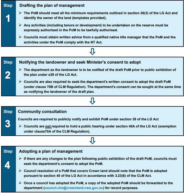
Plan of Management Bulahdelah Showground Appendix 5


