2 minute read
Project Background


Introduction
The Prince George’s County Planning Department initiated this project to advance ongoing pedestrian and bicycle connectivity efforts in the Langley Park area. The overarching aim of this project, as well as several other related ongoing projects in the vicinity, is to improve bicycle and pedestrian connectivity to the proposed Riggs Road Purple Line station and other activity centers in the area. This report documents existing conditions, identifies issues and opportunities, and explains the next steps in the planning process
Project Background
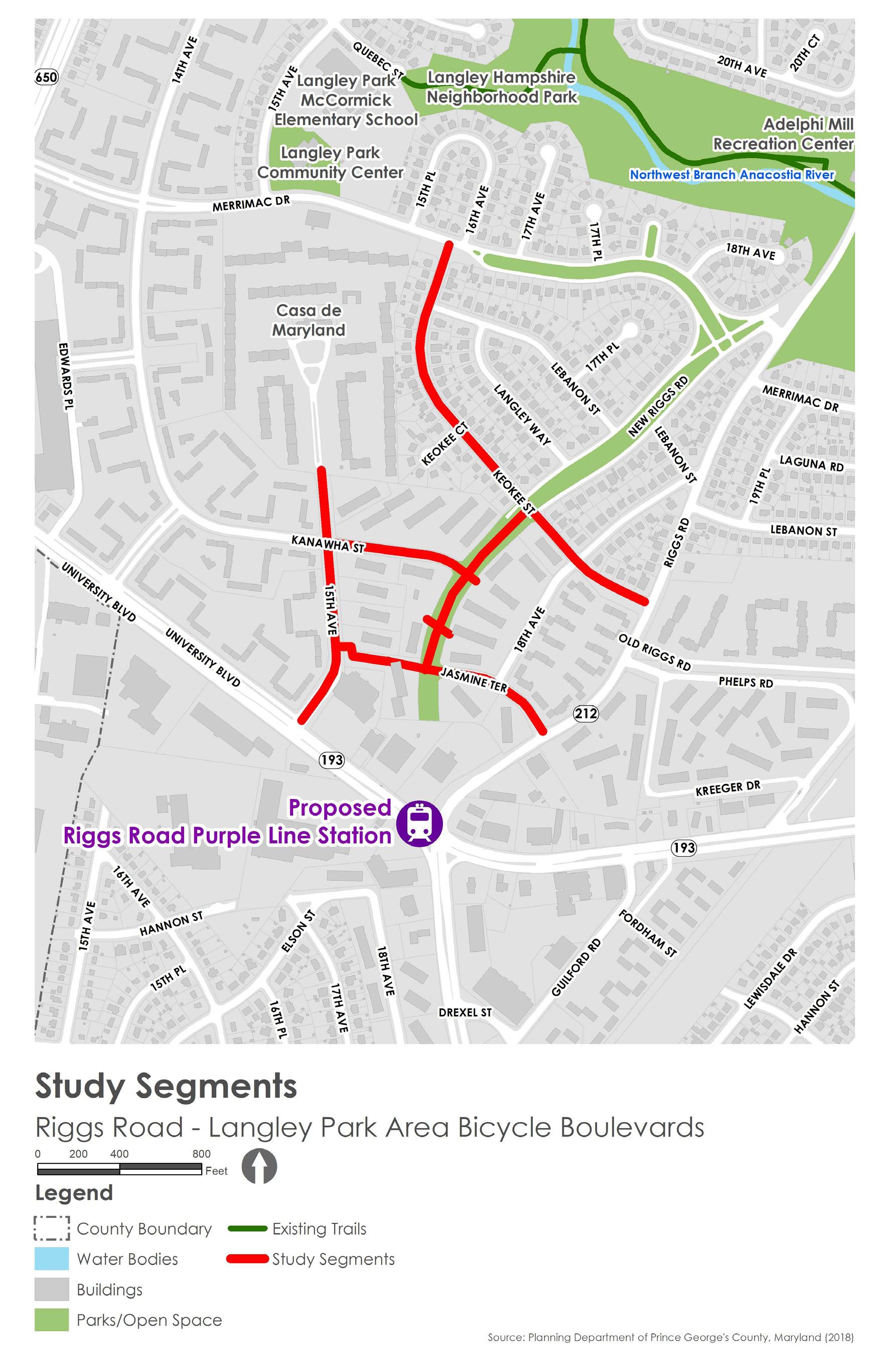
This planning and design project is the outcome of technical assistance provided by the Metropolitan Washington Council of Governments (MWCOG) Transportation-Land Use Connections (TLC) program. Kittelson & Associates Inc. (Kittelson), in collaboration with Rhodeside Harwell Inc. (RHI) and AB Consultants Inc. (ABCI), are providing support to The Maryland-National Capital Park and Planning Commission (M-NCPPC) Prince George’s County Planning Department and Prince George’s County Department of Public Works and Transportation (DPW&T) for this planning and design project. The project team includes members of the consultant team and staff from M-NCPPC, DPW&T, and MWCOG. The project team will evaluate bicycle facility design alternatives and will develop 30% preliminary design plans for a preferred alternative for six study segments in the Langley Park area. The Langley Park area near the intersection of MD 212 (Riggs Road) and MD 193 (University Boulevard) is one of the most densely populated and diverse areas in Maryland. It is designated by MWCOG as an Activity Center and is considered an Equity Emphasis Area. This project will develop a preliminary design for bicycle facilities and highlight the need for enhancing pedestrian facilities that connect the study area to the upcoming Purple Line light rail station and the surrounding mixed-use activity centers. Several previous and ongoing studies analyzed the bicycle and pedestrian connectivity of the neighborhoods surrounding the proposed Purple Line transit stations and identified corridors for improvement. The previous studies identified street segments for enhancing bicycle infrastructure in the study area. This project will build on the previous recommendations and will develop a preliminary design for bicycle facilities along with the following study segments: • 15th Avenue: MD 193 (University Boulevard) to
Villas at Langley Apartments entrance • Keokee Street: Merrimac Drive to MD 212 (Riggs
Road) • Kanawha Street: 15th Avenue to New Riggs Road right-of-way (ROW) • Jasmine Terrace: 15th Avenue to MD 212 (Riggs
Road) • Jasmine Terrace Extension (parking lot): 15th
Avenue to New Riggs Road right-of-way (ROW) • New Riggs Road ROW: Jasmine Terrace to Keokee
Street