

Full Plagiarism Report


By Izzah Sarah Binte Omer Ali Saifudeen (A0289543N)
For NUS MAArC Program AC5007 Semester 2 AY 2024/2025
Supervised By: Dr Johannes Widodo
ExploringtheMaritimeHeritageofSingapore:B...
By:IzzahSarahBinteOmerAliSaifudeen
Asof:Nov10,202411:31:36PM
10,857words-65matches-36sources
sources:
131words/1%-Internetfrom20-Aug-202212:00AM www.clc.gov.sg
27words/<1%match-from19-Jul-202412:00AM www.clc.gov.sg
44words/<1%match-from06-Sep-202412:00AM www.straitstimes.com
26words/<1%match-from02-Nov-202312:00AM www.straitstimes.com
57words/<1%match-Internetfrom15-Nov-202112:00AM uni-tuebingen.de
53words/<1%match-from26-May-202412:00AM biblioasia.nlb.gov.sg
41words/<1%match-from12-Jul-202412:00AM WWW.coursehero.com
8words/<1%match-from05-Nov-202412:00AM www.coursehero.com
41words/<1%match-from03-Nov-202412:00AM www.languagecouncils.sg
35words/<1%match-Internetfrom15-Mar-202212:00AM open-education-repository.ucl.ac.uk
17words/<1%match-Internetfrom08-Dec-202012:00AM ir.unimas.my
14words/<1%match-Internet SitiNoorhidayu,BintiIbrahim."PreliminarystudyofMorphologicalandGeneticDiversityonAsianGreenMussel (Pernaviridis)inSantubong,Sarawak",UniversitiMalaysiaSarawak,(UNIMAS),2014
30words/<1%match-from30-Jul-202412:00AM www.dyslexia.com
24words/<1%match-from26-Jun-202412:00AM ijsshr.in
23words/<1%match-Internetfrom14-Mar-202112:00AM www.researchcatalogue.net
21words/<1%match-from06-Aug-202412:00AM doczz.net
12words/<1%match-from27-Jul-202412:00AM wikimili.com
9words/<1%match-from19-Dec-202312:00AM wikimili.com
20words/<1%match-Crossref MelissaLiowLiSa,SamChoon-Yin."SustainableUrbanDevelopmentinSingapore",SpringerScienceandBusiness MediaLLC,2023
20words/<1%match-Internetfrom09-May-202012:00AM www.nlb.gov.sg
18words/<1%match-YourIndexedDocuments Dessertation_Final_LongSiyu-0422.docx
From:22-Apr-202412:43PM
18words/<1%match-from20-Sep-202412:00AM clovedental.in
18words/<1%match-Internetfrom19-Nov-202012:00AM
in.pinterest.com
17words/<1%match-from10-Sep-202412:00AM www.mdpi.com
15words/<1%match-from09-Sep-202412:00AM repository.uantwerpen.be
14words/<1%match-ProQuest Schuller,Ethan."FacingForward,LookingBack:TransmissionofChineseCultureinSingaporeThroughMusic", WesternIllinoisUniversity,2024
13words/<1%match-Crossref AngeliaPoon."Chapter6TappingintoWeird:ContemporarySingaporeShortFictionbyAmandaLeeKoeandNgYiSheng",SpringerScienceandBusinessMediaLLC,2024
12words/<1%match-Internetfrom19-Jan-202312:00AM popgeogresearch.files.wordpress.com
12words/<1%match-from04-Nov-202412:00AM www.scape.sg
11words/<1%match-Internetfrom19-Oct-202012:00AM rgs-ibg.onlinelibrary.wiley.com
10words/<1%match-from19-May-202412:00AM docslib.org
10words/<1%match-from23-Dec-202312:00AM tnp.straitstimes.com
9words/<1%match-Internet lrd.yahooapis.com
8words/<1%match-from11-Jul-202412:00AM amt-lab.org
8words/<1%match-Internetfrom15-Jan-202312:00AM dspace.unive.it
7words/<1%match-Crossref
HenryJohnson."Islandsofdesign:Reshapingland,seaandspace",Area,2018
papertext:
ExploringtheMaritimeHeritageofSingapore:BridgingHeritageandModernisationByIzzahSarahBinteOmerAli SaifudeenA0289543NForNUSMAArCProgramAC5007Semester2AY2024/2025SupervisedBy:DrJohannes WidodoAbstractSingaporeowesmuchofitsprosperitytoitsmaritimeroots,havinggrownfromahumblefishing villageintotheentrepotitistoday.However,Singapore’sconservationeffortshavepredominantlyfocusedononlythe urbanheritage,leavinghistoricaljetties,piers,harbours,andothermaritimeheritageareasatriskofneglector redevelopment.Thisthesisthusexaminesthesemaritimeheritagespaces’historical,cultural,andcommunalsignificance. Theresearchaimstodrawattentiontothevalueofthesespacesandadvocateformoreinclusiveconservationeffortsthat recognisetheirimportance.Theresearchhighlightsgapsinpolicyandpublicengagementwithmaritimeheritagethrough ethnographicanalysis.ThecasestudieschosenincludeCliffordPier,SembawangJetty,KeppelHarbour,andKelongs. TheresultsshowthatwhilemostSingaporeansrecognisethenation’sislandstatus,theirunderstandingcentresaroundthe urbandevelopmentofSingaporeratherthanitsmaritimelegacy.Asaresult,theproposalintroduceseducationaltoolslike digitalexhibitsandphysicalfocalpointsdesignedtofosterpublicengagementandbalancedevelopmentwith conservation.Literaturereviewsfurthersupplementinvestigations.Mostreviewedworksaresecondarysources,suchas analysesof‘islandness’,conservationpolicies,andmapsofSingapore’shistoricalmaritimeroutes.Unfortunately,the dominanceofEurocentricprinciplesinthereviewedworksoftenoverlooksSingapore’suniquemulticulturalheritage. Moreover,Singapore’sneedformodernisationheavilyinfluencesthespacesprioritisedunderthenation’sconservation policies.Thus,maritimeheritageareasareoftenexcludedinexistingscholarshipandpolicyframeworks.Assuch, primarysourcesareneeded.Byemployingamixedmethodologythatincludesinterviews,siteobservations,andsurveys, thisstudyultimatelyproposesasustainablemaritimeheritageconservationframework.Thisframeworkensuresthese spacesremainsignificantinSingapore’snationalidentityevenasSingaporeevolves.TableofContentsIntroduction BackgroundObjectivesPlaceTimeOverviewofWorksHypothesesSummaryofMethodologyQuantitativeQualitative LiteratureReviewI.TextsaboutIslandnessandContextinSingaporeIslandsofDesignUrbanHeritageinSingapore UtilitarianHeritageII.PoliciesaboutConservationinSingaporePreservationofMonumentsActSixCriteriafor ConservationHeritageBandingFrameworkHistoricalValueAesthetic/ArchitecturalValueCommunal/SocialValue Group/SettingValueIII.MapsGeographicalContextSingaporegrowingHazardsUrbanandConservationPlanning OverallAnalysisMainCausesMethodologyEthnographicFrameworksSpradley’s9dimensionsAEIOUFramework POSTASotirinFrameworkResearchQuestionsInterviewsandSiteVisitsCasualInterviews7
14 14141517191921222223232425252628303637383838434445464848SiteObservationsSurveysResults InterviewResultsSiteObservationResultsSurveyResultsDiscussionMaritimeHeritageastheNationalIdentityNew FrameworkComponentsConclusion50525353545656565758609997wordsIntroductionBackgroundMeowblub-a-bulb.Thatisadesperatematingcryfromacatfish.Canyouguesswhatisconsideredacatfish?TheMerlion,
Singapore’smostfamoushybridiconthatsymbolisestheisland’sfishingrootsandloftyambitions.In1964,thedesign fortheMerlioncamebymergingtwothemes:thelionheadtorepresentSingapura,akathelioncity,andthefishbodyto representthehumbleoriginsofthelittlereddotasafishingvillagecalledTemasek.Temasekwastheprecursorto Singapore’ssuccessasanentrepôt,boastingarichseafaringcultureandastrategiclocation.[1]Yet,Singaporeonly presentsitselfasanultra-modernmetropolis,quietlysidesteppingitsdeeperidentityasanislandnation.Afterall,how elsecanSingaporebagglobalsuperpowersandpowerhouses?AlthoughSingapore’sglobalstandingisprimarilydefined byland-basedarchitectureandtechnology,itshistoricalconnectiontothesearunsfardeeper.Sadly,thisisanoverlooked connectioninfavourofimprovingthecountry’sfacades.However,whatifthenaturalidentitycouldbethenational identity?ObjectivesNationalidentity,oftendefinedasasharedsenseofbelonginganduniqueculturalunderstanding amongstcitizens,isarecurringthemeinthisdissertation.Naturalidentityissupposedtobepartofthisnationalidentity, asnaturalidentitywillencompassuniqueenvironmentalcharacteristicsthathavehistoricallydefinedanation’swayof life.Uponlookingathowthenationalidentityhasevolved,thecoreproblemwiththenaturalidentitybecomes increasinglyapparent.ThereisaweakenedconnectionbetweenSingaporeasanationanditsnaturalmaritime7heritage, withtheonlylinktoasharedpastfueledbynostalgiaduetotherelentlesspursuitofacity-centricidentity.Suchageneric focushasresultedinculturalerosion.Crucialsitesincludejetties,piers,kelongs,andharbours.Literatureonthe conservationeffortsinSingaporeforgeneralbuildingssuggeststhisdisconnectionisnotuniquebutispartofbroader regionalandglobaltrendsfocusingonstructuresthateithershowamoreglamorousnationalityorpromoteefficiencyon landonly.Nowimagineifthisissueisnotresolvedbasedonanalysingzoningandurbantypologieswithinthecountry.In thatcase,futuregenerationswillbecomeevenmoredetached,andSingapore’shistoricalsignificanceasanislandnation willfadeintoagenericcity-stateidentity.Thus,thisresearchdivesintothemaritimeundercurrentsbeneathSingapore’s urbansheenthroughtwoprimarylenses:placeandtime.PlaceForplace-framing,specificarchitecturalfeaturesrelatedto maritimecultureareused.Thisincludesharboursandjetties’traderoutes,markets,ships,andwaterfrontactivities. Specificcasestudies,suchasthekelongs,CliffordPier,andSembawangJetty,willbehighlightedtoshowthebroader maritimelandscape.TimeSecondly,thetimeframegivenisbasedonthelayeringofhistoricalmapsthatillustrate Singapore’slong-standingroleasacriticalglobalport.Crucialmomentsexaminedwillbereputationadvancements, wars,andshiftsinlanduse.AlthoughtheresearchisrelevantforallSingaporeans,particularattentioninthisresearch timelineisgiventotheyoungergenerationsasgroupsarguablythemostdisconnectedfromthecountry’smaritime heritage.Suchlossentailstheir8diminishedconnectiontotheseabeingreplacedwithfasterandmoreaccessiblelandbasedmodesoftransport,areductioninhistoricalknowledge,andashiftinSingapore’sidentityfromanislandnationto acity-state.Theroleofmaritimeheritageas“anchorsofmemory”remainsvital,allowingtangiblesiteslikethese harboursandjettiestosupportcyclesofreinterpretationacrossgenerations.Thisthesiscanthenaddressfundamental researchquestionsonpolicy,engagement,andconservationchallengespresentedlaterinthemethodology.Overviewof WorksInordertofullydigestthesedynamics,acomprehensivereviewofrelevantmapsisneededtounderstandthe historicallayers,includingthelayoutofSingaporeandhowmaritimefeatureshavetransformedthroughoutthedecades, withparticularattentiontoshiftsinlanduse,tradepatterns,andarchitecturaltransformationssincethe1500s.Policy documentsareadditionaltoolstogatherinsightsontheperceivedvalueandrelevanceofmaritimeheritageinSingapore, thusassessingtheextentofculturalerosionandidentifyingpotentialavenuesforconservationwithinthelocalcontext. AsnotedbyBrendaYeoh,LilyKongandLukYingXian,Singapore’sheritageconservationfieldfollowsaWesterncentrictrendthatoverlookslocalhistoricalcontextsandprioritisesurbanstructuresoverlessglamorousmaritimespaces. Lastly,itiscrucialtoestablishacleardefinitionofwhatconstitutesanisland.Shouldtheperceivedimportanceofthese maritimesitesgrowovertime,theselocationsmayevenbecomecentraltoshapingSingapore’snationalidentity, reconnectingfuturegenerationswiththeisland’smaritimepast.HypothesesWithafocusonconservation,therearethen severalassumptionstoguidethisresearch,namelyrelatedtothedemographicandarchitecturalfeaturesatrisk.Young Singaporeansarethemostcrucialgroupfortheconservationofmaritimeheritage.Asfuturecustodians,their understandingandengagementwithmaritimeculturewilldirectlyinfluencehowitispassedtofuturegenerations. Moreover,GenerationZ(GenZ)inparticularisconsideredthemostdigitallyliteratedemographic.Theyarethefirst socialgenerationtohavegrownupwithaccesstotheInternetfromayoungage.However,achievingabetter understandingofsuchanintangibleconceptishardbeyondthetextbooks.Whilepersonalanecdotesfromparentsor grandparentscontributetomaritimeknowledge,theymaynotbesufficienttosustainlastingengagementamongst youngergenerations.ModerndevelopmentsanddigitallifestyleshavedistancedtheseSingaporeansfromreal-life maritimesitessuchasLimChuKangJetty,wherebyyoungerpeoplefavourfictionalcounterpartslikeLiyueHarbour fromGenshinImpact.Additionally,economicdevelopmentandshiftsinlandusehaveledtotheerosionofmaritime featuressuchasjetties,kelongs,andpiers.Thisstudypositsthat,withoutintervention,thesemaritimefeatureswill remainundervalued.ThisundervaluationwillfurtherweakenSingapore’smaritimeheritage.ForSingapore,the conservationofmaritimeheritageservesnotonlytoconservehistoricalnarrativesbutalsotoengageanincreasingly vocalbutdisconnectedgeneration,therebyaddressingthepotentialforcommunicationofthebroadernational significanceofmaritimeheritagetothiscurrentgenerationofSingaporeansandbeyond.10SummaryofMethodology Figure1:TheIshikawaDiagram(ByAuthor)ThefishpartoftheMerlion,representingmaritimeorigins,offersalens thatorganisesthelayeredcomplexitiesofmaritimeheritageerosion.TheIshikawaorfishbonediagram(seeninFigure1) dissectsthecausesbehindthedeclineinconservationforthemaritimeheritagescene.Assuch,thethesisflowwillbe followingthisstructure.First,thisintroductionisplacedatthefish’sheadandhasalreadyhelpedtoidentifythemain issue.IfSingapore’smaritimeheritageareasaresocentraltoitsdevelopmentasamaritimehub,whyhastherebeena declineintheconservationofthesesites,particularlyconcerningengagementbySingaporeans?Fromthere,each‘bone’ ofthediagramleadstoadetailedanalysis.Assuch,theresearchmethodologyadoptsbothqualitativeandquantitative
approachestothesecausesandeffectsoutlinedinthefishbonediagram.QuantitativeQuantitativeanalysis,including historicaldataandexaminingconservationpolicydocuments,identifyeconomictrendsandderivegaps.TheMainCause sectionwillinvestigatetheoverarchingcausesfoundfromtheLiteratureReview.Thisincludestheshifttoland-based development,policygaps,andgenerationaland/orculturaldisengagement.Followingthis,severalprimarygapscanbe pinpointed.GapsinthiscaserefertothespacesofresearchleftunaddressedbytheconservationeffortsinSingapore, suchasthelackofattentiontoeducatingthecitizensaboutmaritimeheritage.Thesegapsthenhighlightthechanging significanceofmaritimefeaturesconcerningevolvingbusinessmodels,policies,andsocietalroles.Bysystematically breakingdowntheproblem,Singaporecangobeyonditsmissingrootswithmaritimeheritageerosionandpropose meaningfulinterventions.QualitativeFromthemorequantitativemethods,keyresearchquestionscanbeformulatedand askedinthequalitativetasksthatwilldeepentheunderstandingofsocialvisionsandgenerationalimpacts.Therefore, thisthesisstudiesthehistoricalsignificanceofSingapore’smaritimeheritagespaceslikejetties,harbours,piersand kelongsascasestudies.Thisworkwilldemonstratehowtheconservationofmaritimeheritageisincreasinglyvitalto understandingnationalidentity.Whilecurrentconservationeffortsprimarilyfocusonbuildingsandurbandevelopment,a morecomprehensiveandinclusivestrategythatemphasisestheconnectionbetweenSingaporeansandmaritimehistoryis essentialforfosteringanauthenticappreciationofSingapore’srootsasanislandnation.Thisthesisthuswillhelp conserveSingapore’smaritimeheritagebeyondactsofnostalgiaandrathermoreascriticalstrategiesforreclaimingthe island’snationalidentity.LiteratureReviewTheliteraturereviewismadeupoftypesofreadingsratherthanthematic categories,aseachtypeoffersdistinctyetinterconnectedperspectivesrelevanttothethesis;(I)TextsaboutIslandness andContextinSingapore,(II)PoliciesaboutconservationinSingaporeand(III)MapsofSingapore’smaritimehistory.I. TextsaboutIslandnessandContextinSingaporeIslandsofDesignIslandsaremultidimensionalspacesbuttheirsizemay notbeenoughtoaccommodateresourcesandfosterdevelopmentsunlesstheyexpandtheirurbanareasbeyondhorizontal expansions[2].In‘
Islandsofdesign:Reshapingland,seaandspace’(HenryJohnson,2018),theauthor forarguesthatthereshapingofislandscanreflecthumanity'sinfluenceongeographyandculturalboundaries,whichalso underscoreshowhumaninterventioncaneithertransformislandsintodynamicspacesorasstaticresources.Thedatais qualitativelyanalysedthroughacriticalcomparativeframework,focusingonanthropogenicchangestoislandlandscape, includinginward,upwardanddownwarddynamics.Thisinvolvesexaminingarangeoftransformationssuchasland reclamation,urbanexpansion,physicaldivisionofislands,andenvironmentallevelling.Theanalysisincludesacritical reviewofrelevantcasestudies,includingManhattanIsland,HongKongInternationalAirport,andvolcanicislandsin Japan,tounderstand theshiftingphysicalityofislandspaceand itsimplicationofislandness.Manhattaninparticularhasexpandedvialandreclamation,anditsurbanlandscapehas grownverticallyduetopopulationdensityandlimitedlandarea.Moreover,thereareextensivebridgesandcanals.Thus, humanactivityhastransformeditsoriginal14islandgeographybutinawaytostillseethemaritimeareas.The explorationofurbanislanddynamicsprovidesacruciallensforunderstandingtheshiftingfocusofislandspaceinthe research.ThisperspectiveenablesthisstudytoproposenewfocalpointsforconservingSingapore'smaritimeculture, emphasisingtheneedtoreframeconservationeffortsinlightofhowanthropogenicchangesarereshapingbothlandand seadynamics.However,whilethetextdiscussesvariousdimensionsofislandreshaping,itprimarilyaddressesthese changesinurbanisation,landreclamation,andenvironmentalimpacts.Thisthesishowevercentresontheculturalerosion ofmaritimeheritageduetheshitsinland-baseddevelopmentinSingapore.Suchagaphighlightstheneedforresearch thatconnectsthesereshapingdynamicsdirectlytotheculturalandhistoricalimpactsonmaritimeheritage,ratherthan focusingsolelyonphysicalandeconomicaspectsofislandtransformations.UrbanHeritageinSingaporePoliciesto people.Policiestoplaces.PoliciestoponderonasseeninLilyKong’sexplorationin‘ ConservingthePast,CreatingtheFuture:UrbanHeritageinSingapore’.Inparticular,Singapore ’spoliciesareaimedtoconservethehistoricallyrelevantstructuresbyadaptingthemforcontemporaryuse,which enhancesthecity’sappealasaglobalhubfortourismandinvestment.Thisapproachbalancesconservationwhile ensuringthecityremainscompetitiveintheglobaleconomy.[3]Thecentralargumentshepresentsishowconservation wouldmaintainthecity’sidentityviaconservinglandmarksthatreflectSingapore’smulticulturalheritageandhistory Thereadingpositionsconservationasacollaborativeeffortinvolvingbothpublicandprivatesectors,withstrong governmentleadershipdrivingthisbalance.Byretainingiconicstructuresandspaces,Singaporestrengthensasenseof continuityandplacewhichnotonlyreinforcesitsnationalidentityasacity,butalsoenhancesthecity’sattractivenesson theglobalstage.Asaresult,Singaporehassuccessfullyconservedmorethan7000buildings,blendingconservation effortswithlarge-scaleredevelopmentprojects.Theworkshowsthesesuccessesbyelaboratingontheseveralphasesof Singapore’sconservationjourney.Thewholeprocessstartedin1954,whereconservationplansweresupposedtobepart ofadraftoftheMasterPlanofficialisedin1958.However,theseplanswereside-linedwhenPAP(People’sActions Party)wontheelectionin1959.PAPwaspro-redevelopmentandintensifieditsstanceasSingaporebecameindependent. Itwasonlyin1963thatconservationwasmentionedaspartofurbanplanningdiscussionsinSingaporewithaUnited Nationsreport.Thismarksthefirstrecordedconsiderationofheritagepreservationyetagainplanswerederaileduntilthe establishmentof thePreservationofMonumentsBoard(PMB)in1971throughanActof Parliament.Thisboardwouldofficiallybegineffortstopreservehistoricallyandarchitecturallysignificantbuildings. Thisincludedtherehabilitationof30state-ownedshophousesonMurrayStreetandTudorCourt.Fromthe1980s onwardsthoughwastheriseofUrbanRedevelopmentAuthority(URA)thatwouldreviewthecitycentreand recommendtheconservationof7key
historicdistricts;BoatQuay,Cairnhill,Chinatown,ClarkeQuay,EmeraldHill,LittleIndiaandKampongGlam .Moreevidenceincludestheirprojectsliketherestorationofshophouses,publicconsultations,privatesector engagement,andtheURAconservationmasterplanfinallyresultedinagreatformofrecognition. TheUrbanLandInstituteGlobalAwardsforExcellencein2006recognisedthe UrbanRedevelopmentAuthority’s16(URA)achievementsinurbanplanning,highlightingtheimpactofagovernment agencyreceivingstaterecognitionforitsefforts.[4]Andthisistheproblemwiththecurrentstrategies.Conservationis onlyaconcernifitistheconservationofatangibleshowofagovernment’ssuccess.Thisskewedfocushasneglectedthe lessvisibleformsofheritageinmaritimestructuresdespitehowtheyhaveshapedthenationalidentity.Kong’searlier workalongwithBrendaYeohexemplifythisissuein UrbanConservationinSingapore:ASurveyofStatePoliciesandPopularAttitudes (1994).Theyhighlighttheresultsofasurveywhere33.7%ofrespondentsarguedlifestylesandactivitiesshouldremain centraltoconservationefforts.Yet,theURAsimplyoptedtoretainthetraditionalactivitiesandintroducenewactivities withoutpropermergerofthetwo.Whileconservationpoliciesmayaimtosatisfyconservationexpertsandmodern developers,theyoftenfailtofullyaddresstheneedsofanygroupandonlythegovernment’sgoals.Thethesisthusneeds tocounterthisgapbyemphasisingtheneedforamoreinclusivestrategythatrecognisesandconservesallaspectsof Singapore’smaritimeheritage,ratherthanlimitingconservationtotheprominentinlandlandmarks.UtilitarianHeritage SomemightblamethiskindofgovernanceduetotheveryforceSingaporeworkedsohardtobreakfreefrom:TheWest. [5]ThereisnodoubthowdominanttheWesternparadigmsareinthefieldofheritageconservation,withalotof emphasisonaestheticsandhistoricalageasprimarymarkersofculturalsignificance.ThisEurocentriclenscannot accountfortheuniquedynamicsfoundinSingapore.However,theseaspectsareoftenoverlookedinfavourofthemore prominentarchitecturalorurbanlandmarks.Inherwork,UtilitarianHeritage:ThePanopticonofNarrativesbehind IndustrialHeritageConservationinSingapore,LukYingXiandiscussesthisbiasformaterialityinrelationtoSingapore’s industrialconservationscene.Thisemphasisestheneedtorethinkwhatconstitutesculturalsignificancebeyondmere physicalattributes.InSingapore,industrialheritagehasbeenovershadowedbythefocusoncolonialandethnicheritage. QuitebizarreconsideringhowtheindustrialheritageofSingaporehasplayedsignificantrolesinformingthesecultures. Singapore’sindustriallandscape,characterisedbyfactories,shipyardsandwarehouses,isdominatedbyseveral communities.ThisisseeninseveralcasestudiessuchastheoneonJurongTownHall(JTH).Localresidents intermingledwithemployeesandworkersinsmallandmedium-sizedenterpriseshousedinJTH,especiallyduringits timeastheiHubandnowtheTradeAssociationHub(TAHub).However,withthegovernment’stop-downapproachin Singapore,JTHwasupgradedtobecomeanationalmonumentinlieuoftheSG50initiative.JTHwouldthenbe primarilyhighlightedasamilestoneundertheleadershipofSingapore’sfoundingfigures.Thisapproachmayrisk overshadowingthecontributionsandexperiencesofthelabourerswhowerepartofJTH’shistory.Insteadofsolely focusingonauthorisednationalnarratives,theremaybevalueingivingspacetothesesmallerstoriestoprovideamore inclusiveviewofSingapore’sheritage.Byincorporatingthevoicesofthesecommunities,amoreholisticviewof heritagecouldhavebeendevelopedtoresonatewithothersandshapeSingapore’suniqueidentity Thus,theauthorcalls uponembracingalternativeframeworksthatreflectlocalculturalsignificancearenecessaryratherthanmerelyfollowing orcopyingWesternmodelsthatfollowsuchanoutdatedhierarchy Thiscallforabroaderdefinitionofcultural significancebeyondphysicalattributesandtopauthorityfiguressupportsthis18thesis’argumentthatcurrent conservationeffortsoftenoverlooktheculturalnarrativesandsocialbondstiedtomaritimeheritage,therebyleadingto lessgenuineappreciationofSingapore’sroots.However,thisreadingdiscussesmostlymaterialityandculturalnarratives, lackingafocusonthechangestobothlandandseadynamicsinthearea.Therefore,thispaperaimstoconnectthese physicaltransformationstotheculturalandhistoricalimpactsonmaritimeheritagetoaddressthiscriticalgap.II.Policies aboutConservationinSingaporeConservinghistoricbuildingsisamultifacetedendeavourthatextendsbeyondmere conservingarchitecture.Whiletherehavebeenseveralkeybodiesintroducedwithinthetextsforislandnessandcontext inSingapore,themethodsemployedaretobeexaminedaswellsincenotonlyaretherestrategiesproposedtohelpwith conservation,butthefuturesoftheseeffortsarediscussedforbetterassessmentofchoosingsuchstrategies. PreservationofMonumentsActThePreservationofMonuments Actistiedtonationalidentity.[6]ThenationalauthorityisthePSM(PreservationofSitesandMonuments)underNHB. Theboard'smainfunctionsunderthisactincludeidentifyingmonumentsofhistorical,cultural,archaeological, architectural,artisticorsymbolicsignificance.SuchresponsibilitiesgainedimportanceduetoSingapore’srelianceon foreignexperts.Hence,localsmadewayformonumentsaround1973asseveralwereannounced. Eightculturallyrepresentativebuildingsweremarkedforconservation
Theseinclude;
1)CathedraloftheGoodShepherd192)ArmenianChurch3)St.Andrew’sCathedral4)HajjahFatimahMosque5)Telok AyerMarket6)ThongChaiMedicalInstitution7)ThianHockKengTemple8)SriMariammanTemple
However,uponcriticalexamination,onewouldnoticemostofthebuildingswerewell-establishedonesandrichwith fundssotherewasnorelianceongovernmentmoney.
CathedraloftheGoodShepherdforexampleistheoldestCatholicchurchinSingapore andwhilethereisnofixedcommunityforthebuilding,manycommunitymembersparticipateinvolunteerworkssuchas liturgicalandoutreachministriesandofcourse,donateextensivelyandthusprovidegoodfinancialsupportforthe Cathedral.Furthermore,thesemonumentsarealreadylinkedtothevariousfaithsinSingaporethatwouldreinforceour nationalidentityasasocially-stable,multiculturalcity Assuch,thisactoverlookssmaller,lessprominentsites,including themaritimeheritagespaces.Thus,thisthesiswillneedmoreinclusiveconservationpoliciesthatemphasisethe importanceofmaritimeheritagespaces.SixCriteriaforConservationFigure2:TheSixCriteriaforConservation[7]The
SixCriteriaforConservationbyURA(seeFigure2)isaframeworkthatassesseswhetherabuildingqualifiesfor conservation.Thisstructureismeantforconservinginthefirststagesofabuilding’srenewedlife.Furthermore,thevalue ofthebuildingsbeingcalledtoquestionextendsbeyondtheirarchitecturalvalue.Theseedificesoftenplaypivotalroles inecosystemsandserveasintegralcomponentsofthesocietalfabric,furtherunderliningtheimportanceoftheir conservation.Theframeworkthususesthefollowingcriteria;1)EconomicContribution2)ArchitecturalMerit3)Rarity 4)Contributiontotheenvironment5)Identity6)Cultural,social,religious,andhistoricalsignificanceThisalignswith thethesisbyseeingthedeeperconnectiontonationalidentity.Inthecaseofthemaritimeheritagespaces,thesespaces aretiedtonationalidentityjustlikethebuildingsassessedunderthisframework.Yet,thisframeworkhasnotbeenused onthesemaritimeheritageareasbecausetheyarenotbuildings.Thus,thethesisneedstoincorporatethesevaluesintoa newframework.HeritageBandingFrameworkTheHeritageBandingFrameworkbyNUS[8]providesapolicylensfor evaluatingheritagesitesbyassigningvaluetokeyaspects:historical,architectural/aesthetic,communal/social,and group/settingvalues.Thisguidecanshowhowsitesshouldbeconservedasthevaluesareexaminedbelow;Historical ValueHistoricalvalueisrelatedtohowthesiteisvitaltoanimportantevent,historicalfigure,phaseoractivity.Some relationsinclude;-RepresentativesbuiltworksofSingapore’surbantransformationandplanningmilestones,orof historical,political,cultural,economicphasesortrends–forexamplenationalbuildingprograms–thatformspartofthe relevantthematicnarratives.-Developmentwithreachandimplicationand/oraccolades/recognition.-Associationwith significantpersonalities/organisations/eventsofsignificance.Aesthetic/ArchitecturalValueTheaestheticand architecturalqualitiesgeneratedbythedesignofabuildingstructurearealsoexamined.Thestrengthofthevaluesis dependentassuchontheform,proportions,massing,vistas,materials,craftsmanshipandhowinnovativethedesignis. Theseincludethefollowing;-Representativeofadevelopment/planning/architecturaltypology,aesthetic,styleand/or trendthatformspartofthethematicnarratives.-Representativeofbuildingtechnology,materialityand/or craftsmanship/execution.-Representationalworkofsignificantbuilder,architect,planner,engineer,developerDevelopmenthasbeenconferredaccolades/recognition,especiallyforitsbuilding/architecturalachievements.-Variety andrangeofbuildingsintermsoffunction,typology,design,hierarchy,phases-Keybuiltstructures/architectural attributesremainintact/legible.Communal/SocialValueCommunalandsocialvaluesareabouttheassociationsthe buildinghaswithothersasasourceofidentity,distinctiveness,everydaylifeandcoherence.-Symbolicvalue,for exampleasarepositoryofcollectivememoryorasreferencepoint/markerofidentity,tothecommunity.-Testimonytoa particularwayoflife,cultureorpractice–abrick-and-mortar/spatialrepositoryofcustoms/socialrituals/habits/social organisationwithinaparticularhistoricmilieu.-Developmentthatisdesignedtopromotesocialcohesion,orthat engenderstructuredcommunities,orthatgenerallyfacilitatessocialconnection,networksandotherrelations.-Continued socialandcommunalrole,initscurrentuseinrelationtoitshistoricprogramme,and/orconnectiontothecommunity. Group/SettingValueFinally,groupandsettinghastobeconsideredintermsofhowabuildingand/orsitehasrelatable featurestotheirorganisationsandthegroupvalueofacluster,andinterrelationbetweensitefeatures/buildingstructures andtothewiderorextendedsetting/context/ecosystemsbeyondthecluster-Representativeshowcaseofsite organisation,groupvalueandinterrelationbetweenstructuresorsitefeatures(masterplan/urbandesign,site layout/configuration)thatarekeysiteattributesofthecluster/subcluster,andcontributestoitslegibility,appreciation,and heritagepresentation.-Thecluster’s/subcluster’sroleinandinterconnectionwithitsextendedsurroundingcontext (beyondthecluster/subclusterboundary)intermsofwiderurbansystems,strategicsiting,planning,developmenthistory. -Naturalenvironmentorurban/manmadesettingthatcontributestothecluster’s/sub-cluster’slegibility,historic function/operation,character,andconnectivitytoothernaturalecosystemsormanmadenetworks.-Historicgroupand settingattributesremainintact/legible.Thisproposedframeworkarguesthatheritageconservationmustmovebeyondthe physicalformofthebuilding.Withaholisticapproach,heritagesitescanstillretaintheirrelevanceandmeaningwithin theevolvingurbanlandscape.Assuch,thisframeworksupportsthisthesisbyshowingthatconservingmaritimeheritage requiresmorethanarchitecturalconservation.Thesocialandcommunalrolesofthemaritimeheritageareasaswellas theirhistoricalconnectionstoSingaporearevitaltounderstandingtheirintangiblevalue.However,connectionsitselfis anissuehere.Specifically,connectionswiththeyoungergenerationofSingaporeans.Thereistheassumptionthat communityinvolvementissufficientforsustainingheritage,ignoringtheneedfortargetedoutreachtoconnectyounger generationsmeaningfullywiththesesites.Therefore,thethesiswouldneedtoproposeamoreinteractiveapproachto maritimeheritageconservation,leveragingcurrenttechnologytomakehistoricalsitesandnarrativesaccessibleand engagingforyoungpeople.III.MapsHistoricalcartographyprovidescriticalinsightsintoSingapore’maritimeheritage, revealingitsstrategicimportanceinglobaltradeandSoutheastAsianmaritimenetworks.Theanalysisofcartographic sourceswillrevealSingapore’sstrategicsignificanceandevolutionofitsroleinglobaltrade.Mainmapsincludethe mapsof1502,1513,1548,1570,1599-1628,1604,1650,1822,1964,1989,and2020.GeographicalContextTheMalay PeninsulaisalargepeninsulainSoutheastAsiathatextendssouthwardfromtheAsianMainland.Itseparatesthe AndamanSea tothewestfromtheSouthChinaSeatotheeastandis borderedbyThailandtothenorthandSingaporetothesouth.SingaporespecificallysitsjustoffthecoastoftheMalay Peninsula,separatedbyJohorStraitandalongtheStrait ofMalacca,whichisoneofthe25busiestshippinglanesintheworld.[9]This positionmakesSingaporeacriticaltransitpointforglobaltrade betweentheIndianOceanandtheSouthChinaSea.Singapore growingHowever,suchsignificancewasnotimmediatelytransparenttoPortugueseandotherEuropeancartographers documentingtheirexplorationsinAsia.[10]CantinoChartfrom1502InthePortugueseseachartof1502,thereisno explicitmentionof‘Cingaporla’or‘Cingatola’whichweretheearliesttranscriptionsofSingapura.1513Mapfrom
MartinWaldseemullerInfact,theMalayPeninsulaitselfwasonlylabelledas‘AureaChersones’(GoldenChersonese)by the1513mapfromMartinWaldseemuller ThisisanindicatorofEuropeanignoranceofthecomplexcoastalregionsand individualsettlementswithinthearea.Itwasonlyby1548thattherewasashifttowardsmorepreciserepresentations. GiacomoGastaldi’s1548map“IndiaTerceraNovaTabula ”showsCCincaPula(CapeofSingapore).Thisisamongstthefirstrecordedinstancesofadistinctreferenceto Singapore,thoughframedmoreasacoastallandmarkthanasignificanttradinghub.
AbrahamOrtelius’smapofSoutheastAsia“Indiaeorientalisinsularumqueadiacientiumtypus”of1570 buildsonthisgrowingrecognition,listingSingaporeasCincapura.Thischangeinnamereflectsanincreasingawareness ofthelocation’sidentity,transitioningfromameregeographicmarkertoaregionwithrecognisedsignificancewithin SoutheastAsia.Finally,CornelisClaeszandTheodordeBry’sMap(1599-1628)demonstrateshowEuropeaninterestin SoutheastAsia’smaritimeroutesmatured.271599-1628ThepairachievedthismapviatracingDutchcolonialvoyages topinpointcriticaltradingpoints.ThisshowshowSingaporeemergedasacrucialnodeintheDutchspicetradenetwork. Assuch,Singaporehasshiftedfromavaguelydefinedwaypointtoacriticaleconomicasset.HazardsWhileearlymaps ofthe1500srevealthegradualrecognitionofSingapore,themapsoftheearly17thcenturybegantocapturethegrowing complexitiesofnavigationandgeopoliticaltensionintheregion.ThisdynamicchangereflectshowSingapore’smaritime heritagewouldhavetoencompassthehazardsandsocialtensionamongstinvolvedgroups.[11]1607The1607mapofde BrystandsoutfordepictingnotonlythegeographicallayoutofSingaporeStraitbutalsonavigationalhazardsand politicalconflicts.Theinclusionoffeatureslike‘ SincaPora(i.e.Singapore),“StraetvanSincaPore(StraitsofSingapore)andValschSincaPore(FalseStraitsof Singapore )reflectsthecomplexityofnavigatingthesewaters.Moreover, themapdepictstheDutch-PortuguesenavalconfrontationinOctober1603 ,markingasignificanteventinSoutheastAsianmaritimehistory Thisconfrontationhighlightstheregion’sstrategic importanceasabattlegroundforcolonialpowers,withSingaporeandJohorLamaservingascriticalnodesinregional alliances.Themap’sshowcaseofthenavalvessels,navigationaldepthsandenvironmentalhazardsillustratesthe29 technicalprecisionneededbytheseshipstonavigatethewaters.ThisoffersearlyevidenceofSingapore’ssignificance, notjustintraderoutesbutasapoliticalflashpointinEuropeancolonialrivalries.StraatSincapuraMapStraatSincapura Map(c.1650)furtheremphasisestheenvironmentalchangesinthestraitbyfocusingonenvironmentalandbathymetric datatoshowgeographicalchallengesandnavigationalroutes.Together,thesemapsdemonstratehowSingapore’s maritimerelevanceextendedbeyondtradebyshowingthetechnical,environmental,andgeopoliticaldynamicsthat shapeditsdevelopment.UrbanandConservationPlanningBythe19thcentury,asEuropeandominancesolidified, attentionshiftedfromnavigatingtheseastocontrollingland-basedresources.Thistransitionwouldnotonlymarktherise andfallofBritishinfluencebutalsohowsuchchangeswouldshowthepoweroflandoversea.WhilethelegendofSang NilaUtamaprovidesanearlyindigenous(albeitmythical)narrativeaboutSingapore’sorigins,colonialhistoriography haveshapedthenation’splanning,withthemostwell-knownfigurebeingSirStamfordRafflesandtheJacksonPlanof 1822[12].Asaproposedscheme,themainaimoftheplanwastomaintaintheorderofSingaporeasacolonyfoundedin 1819.Unfortunately,thisplanwasneverexecutedproperlybutitservedandshowedusaguideforhowSingaporewas supposedtobedeveloped,includinginconservationeffortstoday.Additionally,theinfrastructureformaritimeactivities, includingtheharbours,riversandpiersespecially,wereestablishedwithdirectconnectionstoethnicenclaveslikethe Johnston’sPier(predecessortoCliffordPieranddemolishedin1970)wassituatedintheheartofChinatownandcatered toChinesetradingactivities.WorldWarIIwasarguablytheturningpointforland-baseddominance.Notonlyintermsof howspaceswereutilisedbutalsodeterminingwhocontrolledtheland.ThefallofSingaporein1942putthe vulnerabilitiesoftheisland’scoastaldefencesonfulldisplay.ThisincludedtheBritishdestroyingtheJohor-Singapore Causeway,31whichmadetheJapanesenavigatetheJohorStraitusingmakeshiftmethods,includingsmalljettieslikethe SembawangJettyandswiftlyfocusonadvancingthroughthejungleterrain.Thistargetonland-basedtransportation systemswasespeciallyevidentinthe1942TokyoNichinichiShimbunshamap.[13]Themapdoeshighlightmaritime areaslikethenavalbasesinSembawangandminefieldsinnearbywaters.However,thelargestareamarkedinred belongstothetransportationnetworksliketherailwaylinefromMalaysia.Eventheforestsandhillsthatusedtocover Singaporewereclearlydepictedwithdifferenttreesymbols.IfterrainandinfrastructureinfluencedJapanesemilitary strategy,theirdominanceinSingaporewouldalsohavetobebasedonland.Maritimespaceswereusedtacticallyrather thanstrategically,diminishingtheirlong-termsignificanceinfavourofland-basedsystems.Landtookonevenmore economicalprominenceovertheseawiththeyear1964.[14]Notonlywasthattheyearbeforeindependencefrom Malaysia,but theSingaporeTouristPromotionBoard(STPB)neededtopromoteSingaporeasatouristdestination tosetitselfapartfromthecountryitwasgoingtoleave.Thismarkedthebeginningofanofficialshifttowardsviewing heritageasacommoditytoattractglobaltourists.Figure3:1965MapsbySTPBforTours[15]By1984,theTourism TaskForcehadbeensetup tolookintohowtoboosttourisminSingapore .Assuch,tourismsolidifieditspositionasaproduct/commodityby1986 withthedevelopmentoftheTourismProductDevelopmentPlan aimedatrevitalisinghistoricdistricts.Thus,aCivicandCulturalDistrictMasterPlanExhibitionwasheldtobringout thedistinctivehistoricalqualitiesoftheareaandenhanceitsrelationshipwithOrchardRoad,MarinaBayandthe SingaporeRiver
by1989.OrchardRoadinparticularnaturallytransformedintoacommercialareaasitwasalreadysurroundedbyseveral businessesthatwouldbenefitmassivelyfromthebuildingoftheNorth-SouthMRTlinestations(Orchard,Somerset,and DhobyGhautstations).Unfortunately,theSingaporeRiverandMarinaBayhadtobereimaginednotashubsoftradebut ascuratedtouristattractions.Sincetheriverclean-upcampaignin1983,bumboats[16]thatwereonceessentialfor transportinggoodsarenowferryingpassengersalongtheSingaporeRiverforsightseeingandpleasurerides.Thismere delegationtoriver-taxisbylicensedoperatorswhopickupanddisembarkatBoatQuayandClarkeQuayreflectsthe transitionofaworkingwaterwayintoaleisure-orientedexperience.Meanwhileasseeninthe1988map,landareaswere carefullyplanned.ThisincludestheriseoftheMRTstationsin1987[17]thatsoonbecameessentialtransportation systemstonavigatearoundthecountryasseenintheexpandingnetworks.Thus,waterspacesareretainedonlyinsofaras theycomplementedtheurbandevelopment.Figure4:1988MapofSingaporewiththenewMRTStations[18]Overall AnalysisHence,thesemapsstressonSingapore’sgeographicpositionbeingessentialtomaritimenavigationandglobal trade.Thissignificanceisreflectednotonlyincolonialambitionsbutalsointhetechnicalandenvironmentalaspects crucialfornavigation.ThemapssupportthethesisbydemonstratingSingapore’historicmaritimerole,justifyingthe needformaritimeheritageconservation.TheyshowthatSingapore’sdevelopmentwasdirectlytiedtoitsstrategic locationinmaritimeroutes.Conservationeffortsthereforeshouldmakeuseofthisnavigationaldataandinfrastructure thatformedthefoundationofSingapore’sidentityasamajorport.However,thesemapsreflectcolonialandEurocentric perspectives,focusingonEuropeantradeambitionsandnavigationalneedswhilesideliningindigenousmaritime practices.Thedocumentationisthuslimitedinacknowledginglocalcontributionstomaritimehistory Thethesisthus emphasisesamoreinclusiveconservationstrategytorecognisebothcolonialandlocalnarratives.Additionally,thethesis willincludetheconservationofintangibleheritage(navigationalknowledge)alongsidephysicalinfrastructure,bridging thegapbetweentraditionalpracticesandmodernconservation.MainCausesTheshifttowardsland-baseddevelopment inSingaporereflectstheprioritisationofurbangrowthovertheconservationofmaritimeheritage.Thishasledtopolicy gapsthatneglecttheintegrationofmaritimespacesintocontemporaryconservationstrategies.Additionally,thereisa significantgenerationalandculturaldisengagementfrommaritimeheritagesitesandinthepolicies.Theassumptionthat communityinvolvementaloneissufficientforsustainingheritageoverlookstheneedfortargetedoutreachandeducation initiativestofosteradeeperappreciationforSingapore’maritimehistory Together,thesefactorsuncoveredviathis literaturereview underscoretheurgentneedforamoreinclusiveandholisticapproachto maritimeheritageconservation.MethodologyEthnographicFrameworksHavingidentifiedthemainpotentialcauses,the methodologyneedstogobeyondtheliteraturereviewwithkeyresearchquestionsbasedonresearchgaps.Hence,these researchgapsarederivedfromseveralethnographicframeworksandhighlightedincorrespondingcolourswithinTable A.Bylinkinganyinformationdeemedinadequateormissingtotheissues,eachresearchquestioncanthenberootedin specificareasthatneedtobeaddressed.KeyframeworksincludeSpradley’s9dimensions,AEIOU,Sotirin,andPOSTA. Spradley’s9dimensionsSpradley’s9dimensionsisaframeworkusedtoanalyseandunderstandculturalsettings.These dimensionscanprovideastructuredwaytobreakdownandinterpretvariousaspectsofhumaninteractionandbehaviour withinthemaritimespacesasshownbelow;1)Space:Thephysicallayoutorsettingwhereculturalactivitiestakeplace. KeyplacesincludethefollowinghighlightedinblueandshowninTableA.2)Actors:Thepeopleinvolvedinthe maritimespaces.
Singaporehastwomaincommercialportterminaloperators,namelyPSACorporationLimitedandJurongPort
PSACorporationLimitedmanagesthemajorshareofcontainerhandlinginSingaporewhileJurongPortPteLtdis Singapore’smainbulkandconventionalcargoterminaloperator.Mostof theusersofthespacesarevariedsoitwouldbegoodtocapturetheminsiteobservations.[23]383)Activities:Mostof theseareasareabletosupportawiderangeofactivitiestobestudiedinsiteobservations.Thisincludestransport, shipping,recreationalboating,andfishing.Inparticular,themodernrecreationaluseslikeleisureboatingandfinedining arehighlightingtheshiftfrompurelyindustrialusetomixed-useareas.Sembawang/MataJettyhastobehighlightedhere asthejettyillustratesandreflectsthenaturalabundanceofwildlifeintheareathroughitssimplelayout,fostering connectionsamongvariousfishinggroupsandhobbyistsduringcommunalactivitieslikecrabbingandfishing.Other historicallysignificantmaritimesiteslikeLimChuKangPierhavebeenabandonedandfencedoffduetonotbeingas accessibleasSembawangJetty.Thisdualroleasanaturalsiteandarecreationalhubhighlightsitscontinuedrelevancein modernSingapore,bridgingthepastandpresentthroughasharedappreciationofhistoryandthenaturalenvironment acrossgenerations.However,itshistoricalareasliketheBeaulieuHouse[24]aremostlyknownonlyforitsadaptivereuse asarestaurant.4)Objects:Mostmaritimespacescanaccommodatevarioustypesofvessels,withharboursinparticular beingonalargeenoughscaletotake containerships,bulkcarriers,cargofreighters,coastersandlighters
Additionally,therearevariousphysicalitemsthatsignifytheculturalandhistoricalsignificanceoftheseareas.Notable relicsincludetheiconicredlampsatCliffordPier[25].Infact,duetohowmanysymbolsarepresentatthesite,Clifford Pierhasbeenchosenasoneofthesitestoinvestigate.Thisblendoffunctionalandsymbolicobjectsshowhow intertwinedthecommunity’sidentityiswiththemaritimelandscape.5)Acts:Thesmallerunitsofactivitiesorindividual actions.Everydayactsincludeloadingandunloadingcargo,maintainingvessels,fishing,andrecreationalactivities.6) Events:Pertinenteventsinthesespacesincludetheirestablishmentandcontinuousexpansionorclosure.Basedonthe literaturereview,thedevelopmentofKeppelHarbourinthe19thcenturyisanotableeventtobeinvestigated.7)Goals: TheprimarygoalsofSingapore’smaritimesectorincludesmaintainingitsstatusasaleadingglobalport,promoting sustainabilityinmaritimeactivitiesandintegratingheritageconservationwithmoderneconomicneeds.Onacultural
levelthough,Singaporeonlyseesthebuildingsmostrelatedtothecountryand/orcanpromotetourism.8)Feelings:The emotionalresponsespeoplehavetowardspaceandtheirexperiences.However,thesefeelingsneedtobebetter articulatedandhencecheckedintotoseehowtoelaborateonpeople’sexperienceswithmaritimeheritagespaces.9) Time:Timeofcourseinfluencesthespaceasseenwiththeevolutionofnotjustthemapbutalsotheconservationpolicies thatcontinuedtoonlyfocusonspecificphysicalstructuresmeanttopromoteSingapore.AEIOUFrameworkTheAEIOU frameworkcomplementsSpradley’s9dimensions,wherewefocusontheinteractionsandenvironmenttraitsdescribedas theactivities,usersandobjectshavebeencoveredalready.1)Environment:Theenvironmentsurroundingthesemaritime spacesplays acrucialroleinshapinguserexperiencesandinteractions.InSingapore,theretentionof theislandtypologyisincreasinglychallengingasthenation’sfocusshiftstowardsland-basedtechnological advancementsthataremoreeasilyaccessibletothegeneralpublic.Allbecauseoftheprivatisationofland.Privatisation cancreateascenariowherecommercialintereststakeprecedenceoverheritageconsiderations,thustransformingspaces likeCliffordPierintotheFullertonHotel[25]asanexclusivediningandleisuredestinationthatcatermoretotourists thantolocalcommunities.Incontrastthough,shophousesinlandaremoreaccessibletothepublic,withthefive-footway beinganarcadedcoveredwalkthatrunsalongthefrontofalmostallcommercialshophouses,evenofferingshelterfrom theeffectsoftheweather.[26]Thedifferenceinthesezonesaddtoagrowingdisconnect,unlesssimilarfocalpointsare addedtodrawmorepublicattentiontothemaritimeareas.Moreover,thesetypesofstructuresareunderthreatdueto constantexposuretowavesandstormscausingerosionandstructuraldamages,aswellasrisingsealevelsduetoglobal warmingandpollutionmakingtheseenvironmentslessfriendly.2)Interactions:Theblendofhistoricalcontinuityand modernadaptationwithinmaritimespacesissomethingtobeobservedmore.SembawangJettypreservesitssocialrole asafishingspotandmaritimeviewpoint,continuingitsusesincethe1900s.POSTAThethirdframeworkisPOSTA whichhelpsorganiseobservationsindesignfields.TheacronymstandsforPeople,Objects,Situation,Time,and Activities.Here,thisstudyfocusesonSituationspecifically.1)Situation:Thiscomponentreferstothecontextorsetting inwhichcertainbehaviours,actionsorpracticestakeplace.InthecaseofSingapore’smaritimeheritage,thisrefersto bothphysicalspacesandsocial-culturalelementswherethisheritagemanifests.IncontemporarySingapore,young Singaporeansneedtangible,accessiblefocalpointstoconnectwiththehistoricalmaritimenarrative.Yet,manyexisting culturalanchors,likeplaquesormaritimerelics,areeitherignoredbythepublicorplacedinareasthatarenotconducive toengagement.Traditionalkelongs,whicharewoodenoffshorefishingplatforms,couldhaveservedasonesuchfocal point.KelongsrepresentadirectconnectiontoSingapore’sfishingpast.However,mostkelongstodayareeitherprivately owned,inaccessible,orhavefallenintodisuse.AcompellingexampleisthekelongownedbyTimothyNg,locatedoff PulauUbin.[22]PulauUbinisconsideredout-of-the-wayfortheaverageSingaporean,beinganislandnortheastofthe mainland.Withthelackofaccessibilityanddecreasingneedforthekelongsasfishinggrounds,thekelongisgoingto ceaseoperationsduetofinancialdifficulties.TheSingaporeHeritageSociety(SHS)isactivelypetitioningtoretainthe kelongsasaneducationalandcommunalspacebutafeasibilitystudyisneededtodeterminethecostandinfrastructure neededforconservation.IfkelongslikeTimothyNg’scouldbeconservedandrepurposedassustainabletourismor publiceducationspaces,therecouldbeatangibleconnectionintothefishingpracticesandcommunallifethatwasonce integraltoSingapore’sidentityasanislandnation.Alreadykelongsusedtobepartoflearningjourneysbutmostschools havestoppedgoingthereduetohowfarawaythekelongsare.SotirinFrameworkFinally,theSotirinframeworkin particularisaimedatuncoveringthecomplexitiesandrichnessofhumanexperiencesandrelationships.Keyaspects includeTerritory,People,StuffandTalk.Inthiscase,SotirinmakesuseoftheTerritoryandTalkdimensions.Singapore’s maritimespaceshavelongbeendividedalongbothphysicalandsociallines.TheSingaporeRiveritselfwassegmented intodifferentterritories,withtheHokkiensneartherivermouthatBoatQuayandtheTeochewssettlingfurtherupstream nearColemanBridge.Theseterritorialdivisionswerenotjustgeographicinnaturebutalsorepresentedeconomicand socialdistinctionwithintherivercommunities.Wealthiermerchantsandtraderscontrolledthemoreprofitableand accessiblepartsoftheriverwhilethepoorerlabourerslivedandworkedinovercrowdedandoftenhazardousconditions furtherupstreamoronthefringesoftheback.Yet,thesedialectgroupsintermingledinriversideconversationsabout tradeandcommerceduringcommunalactivities,albeitindirectly Thehighersocialstratawouldnegotiatedealsandthe workerclasswouldgossiponthesetrades.Culturaltransmissionsincludedstorytellerswhowouldreciteoralhistory And then,imaginemoredisplacementswiththe1983RiverClean-Upcampaign.Silencereplacedtheinformaltalks,andeven theboatswerechangedtotouristones.Adaptivereusewasthemainconservationstrategytoproducedozensofcafesand restaurants.Whiletherearesomeheritagetoursthatgoaroundtheriver,thesetoursarestillprimarilyforforeignersand notsomethingtheaverageSingaporeanwouldwanttogoon.[27]ResearchQuestionsAfteranalysingtheframeworks, thefollowingresearchquestionswereformed;●RESEARCHQUESTION1(Evaluative)(Spradley'sFeelings;Goals;All Framework’sActivities):HowshouldeducationalinstitutionsinSingaporeincorporatemorecomprehensivemaritime historyprogramstoenhanceSingaporeans’understandingofthesespacesinthenation'sheritage?Thecomparison betweentheframeworkssuggestsaneducationalgap,wherecurrentprogramsmaynotadequatelyaddresstheimportance ofmaritimeheritage,particularlyconcerningyoungerSingaporeans.Certainhistoricalfactsareknownbutthereisno emotionalconnectionreinforcedinsuchactivities.Thereisaneedforresearchonhowtointegratemaritimehistorymore fullyintoeducationalcurriculatobridgethisgap.●RESEARCHQUESTION2(Testing)(Spradley'sGoals,Actors): ShouldSingapore’sgovernmentimplementstricterregulationsontheredevelopmentofhistoricaljettiesandharboursto balanceeconomicgrowthwiththeconservationofmaritimeheritage?Thereisatensionbetweentheneedtoconserve historicaljettiesandharboursandthepressuretoredeveloptheseareasforcommercialpurposes.Thistensionreflectsa broadergapinpolicyandplanning,wherethebalancebetweenheritageconservationandeconomicdevelopmenthasyet tobeclearlydefined.●RESEARCHQUESTION3(Main)(Spradley’sActivities;AEIOUUser,Interactions;Sotirin’s
Talk):Thisthenleadsustoourmainresearchquestion:Singapore'sharboursandjettieswerecentraltoitsdevelopment asamaritimehub.Why,despiteextensiveconservationinitiatives,hastherebeenadeclineintheconservationofthese sitessincethe1990s,particularlyconcerningengagementbySingaporeans?Thecross-examinationamongstthe frameworkshighlightthelackofengagementandawarenessamongSingaporeansaboutthesignificanceofjettiesand harbours,despiteconservationefforts.Thespecificactivitiesandinteractions(heritagewalks,workshops,etc.)are mentioned,butthereisagapinunderstandingwhytheseeffortshavenotfullyreachedorimpactedSingaporeans, includinghowwell-knowntheyare.InterviewsandSiteVisitsInordertoaddresstheseresearchquestions,amixedmethodapproachwasemployed.CasualInterviewsWhilecasual,theinterviewswereeffectiveinsupplementingthe observationsofthemindsetsoftheusersofthemaritimespace.Participantswereencouragedtosharetheirthoughtson Singaporeandlostactivities.Specificobjectivesincluded;-FindindingouthowmuchofanislandSingaporeisto everyone:WhatdoyouthinkSingaporeisintermsofgeography?-Gatherallmaritimefeaturesthoughtof(ifany)and anylostactivities:WhatdoyouthinkSingaporehasinitsmaritimespaces?VSWhatdoyouthinkSingaporehasinits architecture?-Chartandseehowoftentheoverlapsare:IdentifyingpatternsandtrendsacrossindividualresponsesTogo beyondthenotesistodrawmeaningfulinsights.Theprocessbeganbygatheringrawdatafromthevariousactivitieslike notes,photosandobservationuseractivities.Inthiscase,rawdataisfrombehaviouraldatawiththeobservationofusers inthemaritimespaceandparticipatorydesigndatawiththeinterviewresponses.Thisrawdataisthentranscribedand organisedinavisualformasseenbelowinFigure5;Figure5:AnalysingParticipatoryData(Author’sownreferenced fromFrog[28])Next,dataisgroupedbasedonindividualparticipants.Eachparticipant’sthoughtsandfeedbackare clusteredtoseecommonthemesorrecurringobservations.Fromtheseclusters,thenextstepistoidentifythe ‘opportunityclusters’.Theserepresentareaswhereuniqueinsightsorpotentialopportunitieslie.Patternswithinthe clustersarethenidentified.Thishelpsinunderstandingoverarchingtrendsorcommonviewpoints.Finally,theinsights areanalysedbasedonasetofcriteria.Here,itisthefocusareas,designideas,designprinciplesandarchetypes.Thisis thestagewheretodecidehowparticipants’perceptionsalignwiththeproject’sgoal.SiteObservationsAlongwiththe interviewscamesiteobservations,particularlyatCliffordPier,KeppelHarbour(viewedfromVivoCityasunableto cross)andSembawangJettyviacountingcharts.Countingchartswouldprovideanorganisedmeansoftrackingpublic behaviourandinteractionswiththedesignelementsfeaturedinthesespaces.Theuseofdemographiccodingand timeframesallowsforadetailedunderstandingofsiteusagepatterns.Furthermore,therearearrowstoshowrelations betweentheobserveddemographicsandtheirinteractions.Therearevariousdemographicgroups,categorisedby presumedageandgender;-Youth(0-20yearsold):Yf(female)andYm(male)-Adult(21-60yearsold):Af(female)and Am(male)-Elderly(61andabove):Ef(female)andEm(male)Designelementsrefertothevariousphysicalelements. Commononesinclude;1)Pathway2)Benches3)ViewingPlatforms4)Hotels/Residences5)Grass6)Boat7) Infographics/BoardsActivitiesmostnotablyobservedinthesespaceswouldbe;1)Resting2)Photo-taking3)Talking4) Sightseeing5)Smoking6)Eating7)Exercising488)Caregiving(forkids,pets,elderly)9)Passingby10)Playing11) WorkingObservationswereconductedovertwotimeperiods:oneweekdayandoneweekendacrossthreetimeslots;8:00AM-12:00PM-12:00PM-4:00PM-4:00PM-6:00PM
Therefore,therecanbebetterunderstandingofhowthesespacesfunctionandthediversewaystheyareutilisedbythe public.SurveysAfterconductingtheinterviewsaswellasperformingsiteanalysis,asurveywasdonetoevaluatethe hypothesesand/orsolutions.Essentially,thesurveyhasthefollowingaims;-Findoutwhichfeaturesimpedethefeelings ofislandnessevenintheharbours/jetties-FindoutwhytheycontinuetocomeThesurveyfollowsamultiple-choice structurewithoptionsderivedfromresearchandinterviewandsomeopen-endedquestionstobediscussedintheresults sectionlater Thesurveyhastogatherafewdescriptiveinsightswithintheopen-endedquestions,thusgeneratingaword cloudofthedifferentanswerstowardsthequestion.ResultsInterviewResultsTeninterviewswereperformed.Lookingat theresponseswillgiveabasicbackgroundintermsofwhatextentisSingaporeanislandandhowuniqueitis.This allowsatabletobeplottedthatcandetermineifthereisacorrelationbetweentheconceptof‘islandness’and ‘uniqueness’.Throughaccounts,intervieweesdescribedtheirexperiencesoflifeinSingapore,withmostchoosingto strikeabalancebysayingSingaporeisanisland-city.However,whenaskedtoelaborate,moreurbantermspoppedup andweremorerelatedtolandformsfoundinSingapore.Thisincludedfindingoutwhatarchitecturalfeaturesin Singaporecometomind,likeshophousesandHDBs.Eventhemostmarine-relatedspaceswereabouttheglitzyMarina Bay.Moreover,mostdonotfeellikethereisadifferencebetweenthemarinespacesinSingaporewhenpromptedto thinkmoreaboutthejettiesandharbours,deemingthemboringandnotasoutstandingastheotherformsofarchitecture. Whenitcametotalkingaboutthenaturalenvironmenthowever,theinterviewee’sappreciationforwildlifeinparticular wasprominent,mostcitingtheseaviewandbreezeandhowmanyfishestheycouldcatch.SembawangJettyinparticular waslaudedforthevariousspeciesfoundinitswaters,includinggroupers.Assuch,theseclusterswereformed;●Nature: Appreciationofwildlife●City:Appreciationofthecity●Residential:HDBsandotherspaces●Heritage(Land-based): Shophouses,monuments,etc.●Heritage(Maritime-based):Piers,jetties,etc.Fromtheseresponses,itisclearthatmost oftheurbandevelopmentsthatarrestattentionarestrikingfocalpointsthatstandoutduetoscaleandforms.Any perceptionof‘islandness’tendstobedilutedbythesedevelopmentsbutthiscouldbeanopportunitytomakesimilar attractionsthatwoulddirectthefocustomaritimeareas.Assuch,agreatopportunityclusterscomesfromblending architecturalhighlightswithmarine-basedattractions.Someparticipantsconsistentlydownplaytheuniquenessofmarine spacesbutemphasisetheirappreciationfortheseaview Thisindicatesasecondopportunityclusterforenhancingthe visibilityofmaritimespacesviamorecompellingandfocusedattractions.Theoverallpatternisabouteaseofviewing whichthenmeansthefocusareawouldbetoprioritisemarine-basedspaceswithclearvisibilityandaccessibilityto historicalandstrikingelements.Designideascouldbeopenspaceswithprinciplesrootedinnatureandthebuilt environment.Thisapproachnotonlystrengthensthevisibilityofmaritimeheritageintheseareasbutalsotransforms
themintodynamicfocalpointsthatcelebratethecityanditshistoricaldepths.SiteObservationResultsItisnotedthat arguablythemostpopularandcommonactivityinthesesitesonbothdayswascaregiving.Mostwerespeakingintheir nativetonguesforthelocals,especiallyforthosemindingtheelderlyduetotheirelderspreferringtospeakintheir respectivedialects.Itisnotedthatthevisibilityofcertainactivitiesliketalkingweresignificantlylessforprivacyreasons butthiscausedtheoverallareastobeextremelyquietonweekdaysespecially Weekendsnaturallysawmorefamilies comingtotheareasbutforthemaritimeareaslocatedinthecitylikeCliffordPierespecially,mostofthesegroupswould bepassingbytheareaorjusttakingpictures.NobodyevenbotheredtolookatthetinyplaquerightattheFullerton Hotel’sentrance.Havingrefinedtheunderstandingoftheproblemtoahigherdegreeofclaritywiththeseobservations, theproblemisnowspecifictohowSingapore’sidentityasanislandnationcanbeconservedandrevitalisedviathe designofthemaritimespacesandinformationhubsthatengagethepublic.Theseobservationshelpchecksomeaspects and/orproposedsolutionswithintheanswersforthesurvey.SurveyResultsThesamplesizewaseleven.Most respondentswere25-44yearsold(45.5%)andarestudents(45.5%).Participants’choicesonwhatruinsthe‘islandness’ ofaplaceindicatecommonbeliefsonwhatdifferentiatesanisland.Theseincludelimitedseaviews,absenceofmaritime elementsandpollutionbeingfrequentresponses.Highratingsonnatureandaccessibilityreinforcethesetraitsarevalued forenhancingconnectiontomaritimeheritagesites.Acommonwordchosentodescribemostmaritimeheritageareas wouldbe‘Serene’.Thisisinlinewiththeirreasonsforvisitingmaritimeheritagespacestorelaxinvariouswayslike withphotography.Anyfutureengagementactivitiesthusaresimilarinnatureandareconnectedtonature.Ifso,any designsolutionstoimproveawarenessoftheheritagevalueofthesesitesmustbeconnectedtonature.Already,thereis anoverwhelminglackofinitiativesrelatedtomaritimeheritageaccordingtothesurvey,with72.7%notencounteringany programsthatteachthemaboutSingapore’smaritimeheritage.Overall,thesurveyresultssuggestthatastronger connectionbetweenthecity’snatureanditsmaritimeheritagecouldredefinehowSingaporeansengagewithitscoastal spaces,increasingvisibilityofthesespacesandbeingpartofeducationalefforts.DiscussionMaritimeHeritageasthe NationalIdentityTheprocessofheritageinvolvestherecognitionofthesites.Inthecontextofmaritimeheritage,that wouldinvolvesignificantmaritimelandscapes,structuresandtraditions.Alloftheseaspectsmustthenfitintoabroad conservationframework.Keyenablerstothisactincludegovernmentalpoliciesandlocalcommunitieswhoadvocateor makeupthemaritimeheritagesceneinSingapore.Meanwhile,driverswouldbetheincreasingrecognitionofthe importanceofnationalidentitywiththesemaritimeheritageareas.Thus,thetoolsandprocessesemployedinheritagemakingassolutionswouldbeeducationalinitiatives,designelementsforcomfort,andtechnologiesthatenablebetter visualisationoftheaffectedareas.NewFrameworkandSolutionsThereshouldbeasingularframeworkfocusedsolely onmaritimeheritagethatconsolidatesthecurrentfragmentedapproachesusedforconservation,education,and redevelopment.ThisframeworkcancomefromthemergeroftheSixCriteriaforConservationandtheHeritageBanding Framework.Withintheframework,therewillalsobesolutionstoboostwhatevervalueorfeatureisconsideredlackingif thesitewantstobeconsideredasrelevanttomaritimeheritage.1)PolicyandLegislationwithHistoricValue-The surveydatasuggeststhatrespondentsvaluehistoricalsignificance/communityrolesofmaritimeheritage.Thereisalso greaterdesireformoreinformativeheritageprogrammesandnoted54theimportanceofmaintainingelementslike kelongs.Hence,therecouldbespecificzonestoregulateheritageprogrammingandensurethearearemainsauthentic withitselements.-Thesespecificmaritimezoneswillcomefromassessingthehistoricvaluetothesitesconnectedto significantevents,individuals,andgroups.(eg.,Cashinfamily’sroleatLimChuKangPier)2)Marine-SpecificCriteria withAestheticsvalue-Participantsforboththeinterviewandthesurveymentionedthatthelackofmaritimeelements likefishingboatsasfactorsthatdefractfromthesenseofauthenticmaritimeatmosphereandiftheyonlyseecity-based elements.-Todrawappreciationtowardstheseseeminglymundanestructures,therecanbegamifiedmobileappswith thetaskstoguidethroughtheseaspectssuchasHiddenSGcreatingaself-guidedoutdoorgamethat usessimpleWhatsAppmessagesandanartificialintelligencechatbottohelppeoplefindthemorehole-in-the -wallplaces.Figure8:HiddenSG’screatorLimYeeHung[29]3)ActivitiesforSocialandCommunalValue-Thereisa needtocapturehowcertaincommunitieslikefishinggroups,boaters,andlocalresidentsinteractwithandusethesesites asplacesofidentity,culture,andpractices(eg.,tradepracticesatKeppelHarbour)-Thesespacescanremainrelevant andaccessiblebydesigninginteractiveprogramsthatfosterengagementsuchasstudentprojectsandstorytelling initiativesbytheelderly.4)MaritimeSurroundingsforGroupandSettingValue56-Assessingmaritimeheritagewithin clusterslikeconnectingjettiestolargerecosystemssuchasfishingroutescanbedoneviaarchitecturalethnographic participatorydrawings.-Severalrespondentsnotedtheirexperienceofsereneatmospheressosomethingnotintrusive likevirtualtourscanmaintainthisserenitysincetherewillbenoneedforspeaking.-Aseachpersoncontributesa drawingorrecallsaspottobeadded,theinterrelationsbetweenlandandwater-basedfeatureswillbemoreobviousas peoplewillactivelyhavetorecallimportantpartsoftheroutes.ConclusionInconclusion,thisthesishasdemonstrated thatconservingSingapore’smaritimeheritagespacesisaboutreinterpretingthenation’snaturalidentity.Byexamining variousjetties,harbours,piers,andkelongs,thisworkhasunderscoredthevalueofaconservationapproachthatgoes beyondnostalgicacts.Throughamoreinclusivestrategy,theresearchinvitescommunities,educatorsandpolicymakers toreclaimthemaritimeidentity.Whiletheworkislimitedduetothesmallsamplesizeoflessthantwenty,futureworks shouldfigureoutspecificformsthedesignelementsmusttaketonaturallyframethemaritimespacesthatwould encouragelearningabouttheheritageoftheseareas.LikehowthemerlionwillbeundergoingcleaninginDecember 2024,Singaporeneedstoremembertokeepthemaritimeelementsintactasournationalandnaturalpride.
AcknowledgementsIwouldliketoexpressmyheartfeltgratitudetowardseveryonewhohasaidedmeinmyjourneyin theMastersofArtsinArchitecturalConservationProgrammeinNUS.ToDrJohannesWidodo,thankyouforyour invaluableguidance.Yourinsightshavebeeninstrumentalinshapingmyacademicandprofessionalgrowth.ToDrNikhil JoshiandDrHOPuayPeng,thankyouforinstillingfoundationalknowledgesothatthisthesiscanhaveasoundbasis.
ToLukYingXian,adedicatedPhDstudentandteachingassistant,thankyouforyourendlessfeedbackforthedrafts. Yourinsightshavebeenamassiveboontothiswork.Lastbutnotleast,thankyoutomymum,dadandfurrybrother Loganforallthesupportrenderedthroughoutuniversity.Mymummightaswellbetheco-author.ListofImagesand TablesFigure1:TheIshikawaDiagram(page11)Figure2:TheSixCriteriaforConservation(page20)Figure3:1965 MapsbySTPBfortours(page29)Figure4:1988MapofSingaporewiththenewMRTstation(page31)Figure5: AnalysingParticipatoryData(page44)Figure6:AnexampleoftheInterviewChart(page48)Figure7:Anexampleof theCountingChart(page50)Figure7:AnexampleoftheCountingChart(Source:Author)Figure8:HiddenSG’screator LimYeeHung(page52)TableA:TheDifferentTypesofMaritimeheritagespacesobserved(page35)Listof Appendices1)Jetties:Harbours:Piers:Others:AstructurethatShelteredbodyofAraisedplatformWhatotherwater extendsintothewaterwhereshipsbuiltoverwater,bodiesmakeupwater,providingaandboatscantypicallyusedfor themaritimelandingplaceforanchorsafely,dockingboats,heritageboatsandofferingoftenequippedrecreational protectionfromwithfacilitiesforactivities,andwavesandloading,sometimesasacurrents[19]unloadings,andfishing spot[21]servicingvessels[20]-BedokJetty-Keppel-Clifford-Singapore-ChangiHarborPier:RiverPointFerryTanjongOccupying-Kelongs:TerminalPagartheformerOffshore(ChangiHarborlandingpalisadeJetty)-Serangoon pointoffishtraps-FormerHarborSingapore’sthatonceRoyal-Sembawanforefathers"wereonceMalaysiang Shipyard:acommonNavyDockyardsightin(RMN)forsecuritySingapore’sJetty/andUSwatersWoodlandswarships untiltheyWaterfrontvsthestartedtoJettycommercial dieoutin-Labradorthe1960sJettybecauseof-LimChudecliningKangJettyfishstocks-PulauUbinand,later,Jetty theadvent-Punggolofsea-PointJettybased -Sembawanaquaculturg/MataefarmsinJettythe1980s.".[22]Therearesomeplanstoturnthemintochalets/ed ucationalcentresTableA:TheDifferentTypesofMaritimeheritagespacesobservedBibliography[1]:_People:Yong, ChunYuan& NationalLibraryBoardSingapore.(n.d .).Merlion. https://www.nlb.gov.sg/main/article-detail?cmsuuid=f9c0fd6c-acfa-4eb0-8585-2aa155c1d74d [2]:
Johnson,H.(2018).Islandsofdesign:Reshapingland,seaandspace.Area,52(1),23–29. https://doi.org/10.1111/area.12477 [3]:
Kong,L.(2011).Conservingthepast,creatingthefuture:UrbanheritageinSingapore .URA,1. https://ink.library.smu.edu.sg/soss_research /2287/[4]:CLC.( 2016.).UrbanRedevelopment:FromUrbanSqualortoGlobalCity (pp110).RetrievedMarch15,2024,fromhttps:// www.clc.gov.sg/research-publications/publications/urban-systems-studies/view/urban-redevelopment-from-urbansqualor-to-global-city [5]:Luk,YingXian.(2021).UtilitarianHeritage:ThePanopticonofNarrativesbehindIndustrialHeritageConservation inSingapore.[6]:CLC.( 2016.).UrbanRedevelopment:FromUrbanSqualortoGlobalCity (pp108-109).RetrievedMarch15,2024,fromhttps:// www.clc.gov.sg/research-publications/publications/urban-systems-studies/view/urban-redevelopment-from-urbansqualor-to-global-city [7]: CLC.(2019).Past,PresentandFuture:ConservingtheNation’sBuiltHeritage .RetrievedMarch15,2024,from https://www.clc.gov.sg/research-publications/publications/urban-systems-studies/view/conserving-the-nations-builtheritage [8]:Idon’tknowhowtociteit,butit’sfromNUSDrPuayPeng’sAC5002slides[9]:SitiNoorhidayu,B.I.( 2014).PreliminarystudyofMorphologicalandGeneticDiversityonAsianGreenMussel(Pernaviridis)inSantubong, Sarawak .https://core.ac.uk/download/301744603.pdf[10]:SearchingforSingaporeinOldMapsandSeaCharts.(n.d.).https:// biblioasia.nlb.gov.sg/vol-11/issue-1/apr-jun-2015/search-sg -old-map/[11]:EarlyMapsofSingapore.(n.d.). https://biblioasia.nlb.gov.sg/vol-3/issue2/jul -2007/early-map-singapore/[12]:Tan,B.(n.d.).RafflesTownPlan(JacksonPlan). https://www.nlb.gov.sg/main/article-detail?cmsuuid=ed0c1981-882f-42c2-9acf-e5dae577a3ba [13]:JapaneseMapofSingapore|ChangiChapelandMuseum.(n.d.). https://www.nhb.gov.sg/changichapelmuseum/collection/artefact-highlights/japanese-map-of-singapore[14]:CLC.( 2016.).UrbanRedevelopment:FromUrbanSqualortoGlobalCity (pp107).RetrievedMarch15,2024,fromhttps:// www.clc.gov.sg/research-publications/publications/urban-systems-studies/view/urban-redevelopment-from-urbansqualor-to-global-city [15]:SingaporeTourismBoard(1965).{MapofSingapore:1stedition].Omega[16]:_People:Cornelius,Vernon&
NationalLibraryBoardSingapore.(n.d .).Bumboats.
https://www.nlb.gov.sg/main/article-detail?cmsuuid =6d2b5d54-beeb-4c12-9e2b-a261a251dfc9[17]:_People:Ho,Stephanie& NationalLibraryBoardSingapore.(n.d .).MassRapidTransit(MRT)system. https://www.nlb.gov.sg/main/article-detail?cmsuuid =319cadae-e684-41bc-b7b6-3bd4b06437d2[18]:Singapore,O.(n.d.).OneMap|HistoricalMapGallery. https://www.onemap.gov.sg/historicalmaps/#[19]: Dictionary.com|Meanings&DefinitionsofEnglishWords.(2021).InDictionary.com. https://www.dictionary.com/browse /jetty#google_vignette[20]: Dictionary.com|Meanings&DefinitionsofEnglishWords.(2021b).InDictionary.com. https://www.dictionary.com/browse/harbor[21]:Dictionary.com|Meanings&DefinitionsofEnglishWords.(2021a).In Dictionary.com.https://www.dictionary.com/browse /pier[22]:Gene,N.K.(2024,September1).
FateofoneofSingapore’slastkelongshangsinthebalance.TheStraitsTimes .https://www.straitstimes.com/singapore/ fate-of-one-of-singapore-s-last-kelongs-hangs-in-the-balance [23]:Terminals.(n.d.).Maritime& PortAuthorityofSingapore(MPA).https://www.mpa.gov.sg/port-marine-ops/operations/port-infrastructure /terminals[24]:BeaulieuHouse.(n.d.).
https://www.roots.gov.sg/places/places-landing/Places/landmarks/Sembawang-Heritage-Trail /Beaulieu-House[25]:
TransformingCliffordPierBuildingandCustomsHouse:TheFullertonHeritage .(n.d.).
https://www.roots.gov.sg/stories-landing/stories/transforming-clifford-pier-building-and-customs-house-the-fullertonheritage/story [26]:The“five-footway”ofashophouse.(n.d.). https://www.roots.gov.sg/Collection-Landing/listing /1015185[27]:_
People:Cornelius,Vernon&NationalLibraryBoardSingapore.(n.d.-b).SingaporeRiver communities.
https://www.nlb.gov.sg/main/article-detail?cmsuuid =b821c72a-9035-49e8-bcb7-a95bbd9443c9[28]:Frog.(2014,March6).
BringingUsersintoYourProcessThroughParticipatoryDesign[Slideshow].SlideShare.https://www.slideshare.net /slideshow/bringing-users-into-your-process-through-participatory-design /31975488#71[29]:Lim,J.(2023,October24).
NewWhatsApp-basedgamehighlightsSingapore’shiddengems.TheStraitsTimes .https://www.straitstimes.com/ singapore/new-whatsapp-based-game-highlights-singapore-s-hidden-gems 12345691112131517202122232426283032333435363739
58596061626364656667
Exploring the Maritime Heritage of Singapore: Bridging Heritage and
Modernisation
By Izzah Sarah Binte Omer Ali Saifudeen (A0289543N)
For NUS MAArC Program AC5007 Semester 2 AY 2024/2025
Supervised By: Dr Johannes Widodo
Abstract
Singapore owes much of its prosperity to its maritime roots, having grown from a humble fishing village into the entrepôt it is today However, Singapore’s conservation efforts have predominantly focused on only the urban heritage, leaving historical jetties, piers, harbours, and other maritime heritage areas at risk of neglect or redevelopment. This thesis thus examines these maritime heritage spaces’ historical, cultural, and communal significance. The research aims to draw attention to the value of these spaces and advocate for more inclusive conservation efforts that recognise their importance.
The research highlights gaps in policy and public engagement with maritime heritage through ethnographic analysis. The case studies chosen include Clifford Pier, Sembawang Jetty, Keppel Harbour, and Kelongs. The results show that while most Singaporeans recognise the nation’s island status, their understanding centres around the urban development of Singapore rather than its maritime legacy. As a result, the proposal introduces educational tools like digital exhibits and physical focal points designed to foster public engagement and balance development with conservation.
Literature reviews further supplement investigations. Most works are secondary sources, such as analyses of ‘islandness’, conservation policies, and maps of Singapore’s historical maritime routes. Unfortunately, the dominance of Eurocentric principles in the reviewed works often overlooks Singapore’s unique multicultural heritage. Moreover, Singapore’s need for modernisation heavily influences the spaces prioritised under the nation’s conservation policies. Thus,
maritime heritage areas are often excluded from existing scholarship and policy frameworks. As such, primary sources are needed. By employing a mixed methodology that includes interviews, site observations, and surveys, this study ultimately proposes a sustainable maritime heritage conservation framework. This framework ensures these spaces remain significant in Singapore’s national identity even as Singapore evolves.
Acknowledgements
I would like to express my heartfelt gratitude towards everyone who has aided me in my journey in the Masters of Arts in Architectural Conservation Programme in NUS.
To Dr Johannes Widodo, thank you for your invaluable guidance. Your insights have been instrumental in shaping my academic and professional growth.
To Dr Nikhil Joshi and Dr HO Puay Peng, thank you for instilling foundational knowledge so that this thesis can have a sound basis.
To Luk Ying Xian, a dedicated PhD student and teaching assistant, thank you for your endless feedback on the drafts. Your insights have been a massive boon to this work.
Last but not least, thank you to my mum, dad and furry brother Logan for all the support rendered throughout university My mum might as well be the co-author
List of Images and Tables
Figure 1: The Ishikawa Diagram (page 11)
Figure 2: The Six Criteria for Conservation (page 21)
Figure 3: Cantino Chart from 1502 (page 26)
Figure 4: 1513 Map from Martin Waldseemuller (page 27)
Figure 5: 1599-1628 Map (page 28)
Figure 6: 1607 Map (page 29)
Figure 7: Straat Sincapura Map in 1650 (page 30)
Figure 8: Raffles Town Plan (page 31)
Figure 9: Tokyo Nichinichi Shimbunsha Map (page 32)
Figure 10: 1965 Maps by STPB for Tours (page 34)
Figure 11: Bumboats (page 35)
Figure 12: 1988 Map of Singapore with the new MRT Stations (page 36)
Figure 13: Analysing Participatory Data (page 47)
Figure 14: Word Cloud (page 54)
Table A: The Different Types of Maritime heritage spaces observed (page 64)
Chapter 1: Introduction
Meow-blub-a-bulb. That is a catfish's desperate mating cry. Can you guess what is considered a catfish? The Merlion, Singapore’s most famous hybrid icon that symbolises the island’s fishing roots and lofty ambitions. In 1964, the design for the Merlion came by merging two themes: the lion head to represent Singapura, aka the lion city, and the fish body to represent the humble origins of the little red dot as a fishing village called Temasek. Temasek was the precursor to Singapore’s success as an entrepôt, boasting a rich seafaring culture and a strategic location.1Yet, Singapore only presents itself as an ultra-modern metropolis, quietly sidestepping its deeper identity as an island nation. After all, how else can Singapore bag global superpowers and powerhouses? Although Singapore’s global standing is primarily defined by land-based architecture and technology, its historical connection to the sea runs far deeper Sadly, this is an overlooked connection in favour of improving the country’s facades. However, what if the natural identity could be the national identity?
Chapter 1.1: Objectives
National identity, often defined as a shared sense of belonging and unique cultural understanding amongst citizens, is a recurring theme in this dissertation. Natural identity is supposed to be part of this national identity, as natural identity will encompass unique environmental characteristics (including the built environment) that have historically defined a nation’s way of life. Upon looking at how the national identity has evolved, the core problem with the natural identity becomes increasingly apparent. There is a weakened connection between Singapore as a
1 Yong, Chun Yuan (2016) Merlion National Library Board Singapore https://wwwnlb govsg/main/article-detail?cmsuuid=f9c0fd6c-acfa-4eb0-8585-2aa155c1d74d
nation and its natural maritime heritage, with the only link to a shared past being nostalgia due to the relentless pursuit of a city-centric identity. Such a generic focus has resulted in cultural erosion. Crucial sites include jetties, piers, kelongs, and harbours. Literature on the conservation efforts in Singapore for general buildings suggests this disconnection is not unique but is part of broader regional and global trends focusing on structures that either show a more glamorous nationality or promote efficiency on land only. Now, imagine if this issue is not resolved based on analysing zoning and urban typologies within the country In that case, future generations will become even more detached, and Singapore’s historical significance as an island nation will fade into a generic city-state identity Thus, this research dives into the maritime undercurrents beneath Singapore’s urban sheen through two primary lenses: place and time.
Place
For place-framing, specific architectural features related to maritime culture are used. This includes harbours and jetties’ trade routes, markets, ships, and waterfront activities. Specific case studies, such as the kelongs, Clifford Pier, and Sembawang Jetty, will be highlighted to show the broader maritime landscape.
Time
Secondly, the timeframe given is based on the layering of historical maps that illustrate Singapore’s long-standing role as a critical global port Crucial moments examined will be reputation advancements, wars, and shifts in land use. Although the research is relevant for all Singaporeans, particular attention in this research timeline is given to the younger generations as groups arguably the most
disconnected from the country’s maritime heritage. Such loss entails their diminished connection to the sea being replaced with faster and more accessible land-based modes of transport, a reduction in historical knowledge, and a shift in Singapore’s identity from an island nation to a city-state. The role of maritime heritage as “anchors of memory ” remains vital, allowing tangible sites like these harbours and jetties to support cycles of reinterpretation across generations. This thesis can then address fundamental research questions on policy, engagement, and conservation challenges presented later in the methodology
Chapter 1.2: Overview of Works
In order to fully digest these dynamics, a comprehensive review of relevant maps is needed to understand the historical layers, including the layout of Singapore and how maritime features have transformed throughout the decades, with particular attention to shifts in land use, trade patterns, and architectural transformations since the 1500s. Policy documents are additional tools to gather insights on the perceived value and relevance of maritime heritage in Singapore, thus assessing the extent of cultural erosion and identifying potential avenues for conservation within the local context. As noted by Brenda Yeoh, Lily Kong, and Luk Ying Xian, Singapore’s heritage conservation field follows a Western-centric trend that overlooks local historical contexts and prioritises urban structures over humble maritime spaces. Lastly, it is crucial to establish a clear definition of what constitutes an island. Should the perceived importance of these maritime sites grow over time, these locations may even become central to shaping Singapore’s national identity, reconnecting future generations with the island’s maritime past.
Chapter 1.3: Hypotheses
With a focus on conservation, there are then several assumptions to guide this research, namely related to the demographic and architectural features at risk. Young Singaporeans are the most crucial group for the conservation of maritime heritage. As future custodians, their understanding and engagement with maritime culture will directly influence how it is passed to future generations. Moreover, Generation Z in particular is considered the most digitally literate demographic2 . They are the first social generation to have grown up with access to the Internet from a young age. However, achieving a better understanding of such an intangible concept is hard beyond the textbooks. While personal anecdotes from parents or grandparents contribute to maritime knowledge, they may not be sufficient to sustain lasting engagement amongst younger generations. Modern developments and digital lifestyles have distanced these Singaporeans from real-life maritime sites such as Lim Chu Kang Jetty, whereby youth favour fictional counterparts like Liyue Harbour from Genshin Impact
Additionally, economic development and shifts in land use have led to the erosion of maritime features such as jetties, kelongs, and piers. This study posits that, without intervention, these maritime features will remain undervalued. This undervaluation will further weaken Singapore’s maritime heritage. For Singapore, the conservation of maritime heritage serves not only to conserve historical narratives but also to engage an increasingly vocal but disconnected generation, thereby addressing the potential for communication of the broader national
2 Chan, C K Y, & Lee, K K W (2023) The AI generation gap: Are Gen Z students more interested in adopting generative AI such as ChatGPT in teaching and learning than their Gen X and millennial generation teachers? Smart Learning Environments https://doi org/10 1186/s40561-023-00269-3
significance of maritime heritage to this current generation of Singaporeans and beyond.
Chapter 1.4: Summary of Methodology

The fish part of the Merlion, representing maritime origins, offers a lens that organises the layered complexities of maritime heritage erosion. The Ishikawa or fishbone diagram (seen in Figure 1) dissects the causes behind the decline in conservation for the maritime heritage scene. As such, the thesis flow will be following this structure.
First, this introduction is placed at the fish’s head and has helped to identify the main issue. If Singapore’s maritime heritage areas are so central to its development
Figure 1: The Ishikawa Diagram (Source: By Author)
as a maritime hub, why has there been a decline in the conservation of these sites, particularly concerning engagement by Singaporeans?
From there, each ‘bone’ of the diagram leads to a detailed analysis. As such, the research methodology adopts both qualitative and quantitative approaches to these causes and effects outlined in the fishbone diagram.
Quantitative
Quantitative analysis includes historical data and examining conservation policy documents, identifying economic trends and deriving gaps.
The Main Cause section will investigate the overarching causes found from the Literature Review. This includes the shift to land-based development, policy gaps, and generational and/or cultural disengagement.
Following this, several primary gaps can be pinpointed. Gaps in this case refer to the spaces of research left unaddressed by the conservation efforts in Singapore, such as the lack of attention to educating the citizens about maritime heritage. These gaps then highlight the changing significance of maritime features concerning evolving business models, policies, and societal roles. By systematically breaking down the problem, Singapore can go beyond its missing roots with maritime heritage erosion and propose meaningful interventions.
Qualitative
From the more quantitative methods, key research questions can be formulated and asked in the qualitative tasks that will deepen the understanding of social visions and generational impacts. These tasks include interviews, surveys, and site-observations. Therefore, this thesis studies the historical significance of Singapore’s maritime heritage spaces like jetties, harbours, piers and kelongs as case studies. This work will demonstrate how the conservation of maritime heritage is increasingly vital to understanding national identity While current conservation efforts primarily focus on buildings and urban development, a more comprehensive and inclusive strategy that emphasises the connection between Singaporeans and maritime history is essential for fostering an authentic appreciation of Singapore’s roots as an island nation. This thesis thus will help conserve Singapore’s maritime heritage beyond acts of nostalgia and rather more as critical strategies for reclaiming the island’s national identity.
Chapter 2: Literature Review
The literature review is made up of types of readings as each type offers distinct yet interconnected perspectives relevant to the thesis; (I) Texts about Islandness and Context in Singapore, (II) Policies about conservation in Singapore and (III) Maps of Singapore’s maritime history.
Chapter 2.1: Texts about Islandness and Context in Singapore
Islands of Design
Islands are multidimensional spaces, but their size may not be enough to accommodate resources and foster developments unless they expand their urban areas beyond horizontal expansions3 . In ‘Islands of design: Reshaping land, sea and space’ (Henry Johnson, 2018), the author for argues that the reshaping of islands can reflect humanity's influence on geography and cultural boundaries, which also underscores how human intervention can either transform islands into dynamic spaces or as static resources. The data is qualitatively analysed through a critical comparative framework, focusing on anthropogenic changes to island landscape, including inward, upward and downward dynamics. This involves examining a range of transformations such as land reclamation, urban expansion, physical division of islands, and environmental levelling. The analysis includes a critical review of relevant case studies, including Manhattan Island, Hong Kong International Airport, and volcanic islands in Japan, to understand the shifting physicality of island space and its implication of islandness. Manhattan in particular has expanded via land reclamation, and its urban landscape has grown
3 Johnson, H (2018) Islands of design: Reshaping land, sea and space Area, 52(1) https://doi org/10 1111/area 12477
vertically due to population density and limited land area. Moreover, there are extensive bridges and canals. Thus, human activity has transformed its original island geography but in a way to still see the maritime areas. The exploration of urban island dynamics provides a crucial lens for understanding the shifting focus of island space in the research. This perspective enables this study to propose new focal points for conserving Singapore's maritime culture, emphasising the need to reframe conservation efforts in light of how anthropogenic changes are reshaping both land and sea dynamics. However, while the text discusses various dimensions of island reshaping, it primarily addresses these changes in urbanisation, land reclamation, and environmental impacts. This thesis however centres on the cultural erosion of maritime heritage due the shits in land-based development in Singapore. Such a gap highlights the need for research that connects these reshaping dynamics directly to the cultural and historical impacts on maritime heritage, rather than focusing solely on physical and economic aspects of island transformations.
Urban Heritage in Singapore
Policies to people. Policies to places. Policies to ponder on as seen in ‘Conserving the Past, Creating the Future: Urban Heritage in Singapore’ (Lily Kong, 2012). In particular, Singapore’s policies are aimed to conserve the historically relevant structures by adapting them for contemporary use, which enhances the city’s appeal as a global hub for tourism and investment 4 This approach balances conservation while ensuring the city remains competitive in the global economy.
4 Kong, L (2011) Conserving the past, creating the future: Urban heritage in Singapore URA https://ink librarysmu edu sg/soss research/2287/
The central argument she presents is how conservation would maintain the city’s identity via conserving landmarks that reflect Singapore’s multicultural heritage and history The reading positions conservation as a collaborative effort involving both public and private sectors, with strong government leadership driving this balance. By retaining iconic structures and spaces, Singapore strengthens a sense of continuity and place which not only reinforces its national identity as a city, but also enhances the city’s attractiveness on the global stage. As a result, Singapore has successfully conserved more than 7000 buildings, blending conservation efforts with large-scale redevelopment projects. The work shows these successes by elaborating on the several phases of Singapore’s conservation journey The whole process started in 1954, where conservation plans were supposed to be part of a draft of the Master Plan officialised in 1958. However, these plans were side-lined when PAP (People’s Actions Party) won the election in 1959. PAP was pro-redevelopment and intensified its stance as Singapore became independent. It was only in 1963 that conservation was mentioned as part of urban planning discussions in Singapore with a United Nations report. This marks the first recorded consideration of heritage preservation yet again plans were derailed until the establishment of the Preservation of Monuments Board (PMB) in 1971 through an Act of Parliament. This board would officially begin efforts to preserve historically and architecturally significant buildings. This included the rehabilitation of 30 state-owned shophouses on Murray Street and Tudor Court. From the 1980s onwards though was the rise of Urban Redevelopment Authority (URA) that would review the city centre and recommend the conservation of 7 key historic districts; Boat Quay, Cairnhill, Chinatown, Clarke Quay, Emerald Hill, Little India and Kampong Glam. More evidence includes their projects like the
restoration of shophouses, public consultations, private sector engagement, and the URA conservation master plan finally resulted in a great form of recognition. The Urban Land Institute Global Awards for Excellence in 2006 recognised the Urban Redevelopment Authority’s (URA) achievements in urban planning, highlighting the impact of a government agency receiving state recognition for its efforts.5 And this is the problem with the current strategies. Conservation is only a concern if it is the conservation of a tangible show of a government’s success. This skewed focus has neglected the less visible forms of heritage in maritime structures despite how they have shaped the national identity. Kong’s earlier work along with Brenda Yeoh exemplify this issue in ‘Urban Conservation in Singapore: A Survey of State Policies and Popular Attitudes’ (Lily Kong, Brenda Yeoh, 1994). They highlight the results of a survey where 33.7% of respondents argued lifestyles and activities should remain central to conservation efforts.6 Yet, the URA simply opted to retain the traditional activities and introduce new activities without proper merger of the two. While conservation policies may aim to satisfy conservation experts and modern developers, they often fail to fully address the needs of any group and only the government’s goals. The thesis thus needs to counter this gap by emphasising the need for a more inclusive strategy that recognises and conserves all aspects of Singapore’s maritime heritage, rather than limiting conservation to the prominent inland landmarks.
5 Centre for Liveable Cities (2016 ) Urban Redevelopment: From Urban Squalor to Global City CLC https://wwwclc govsg/research-publications/publications/urban-systems-studies/view/urban-redevelopment-from-urba n-squalor-to-global-city
6 Kong, L , & Yeoh, B S A (1994) Urban Conservation in Singapore: A Survey of State Policies and Popular Attitudes Urban Studies, 31(2), 247–265 https://doi org/10 1080/00420989420080231
Utilitarian Heritage
Some might blame this kind of governance due to the very force Singapore worked so hard to break free from: The West 7 There is no doubt how dominant the Western paradigms are in the field of heritage conservation, with a lot of emphasis on aesthetics and historical age as primary markers of cultural significance. This Eurocentric lens cannot account for the unique dynamics found in Singapore. However, these aspects are often overlooked in favour of the more prominent architectural or urban landmarks. In her work, ‘Utilitarian Heritage: The Panopticon of Narratives behind Industrial Heritage Conservation in Singapore’ (Luk Ying Xian, 2021), Luk Ying Xian discusses this bias for materiality in relation to Singapore’s industrial conservation scene. This emphasises the need to rethink what constitutes cultural significance beyond mere physical attributes. In Singapore, industrial heritage has been overshadowed by the focus on colonial and ethnic heritage. Quite bizarre considering how the industrial heritage of Singapore has played significant roles in forming these cultures. Singapore’s industrial landscape, characterised by factories, shipyards and warehouses, is dominated by several communities. This is seen in several case studies such as the one on Jurong Town Hall (JTH). Local residents intermingled with employees and workers in small and medium-sized enterprises housed in JTH, especially during its time as the iHub and now the Trade Association Hub (TA Hub). However, with the government’s top-down approach in Singapore, JTH was upgraded to become a national monument in lieu of the SG50 initiative. JTH would then be primarily highlighted as a milestone under the leadership of Singapore’s founding figures. This approach may risk overshadowing the contributions and experiences of the 7 Luk, Ying Xian (2021) Utilitarian Heritage: The Panopticon of Narratives behind
Industrial Heritage Conservation in Singapore
labourers who were part of JTH’s history. Instead of solely focusing on authorised national narratives, there may be value in giving space to these smaller stories to provide a more inclusive view of Singapore’s heritage. By incorporating the voices of these communities, a more holistic view of heritage could have been developed to resonate with others and shape Singapore’s unique identity Thus, the author calls upon embracing alternative frameworks that reflect local cultural significance are necessary rather than merely following or copying Western models that follow such an outdated hierarchy This call for a broader definition of cultural significance beyond physical attributes and top authority figures supports this thesis’ argument that current conservation efforts often overlook the cultural narratives and social bonds tied to maritime heritage, thereby leading to less genuine appreciation of Singapore’s roots. However, this reading discusses mostly materiality and cultural narratives, lacking a focus on the changes to both land and sea dynamics in the area. Therefore, this paper aims to connect these physical transformations to the cultural and historical impacts on maritime heritage to address this critical gap.
Chapter 2.2: Policies about Conservation in Singapore
Conserving historic buildings is a multifaceted endeavour that extends beyond mere conserving architecture. While there have been several key bodies introduced within the texts for islandness and context in Singapore, the methods employed are to be examined as well since not only are there strategies proposed to help with conservation, but the futures of these efforts are discussed for better assessment of choosing such strategies.
Preservation of Monuments Act
The Preservation of Monuments Act is tied to national identity.5 The national authority is the PSM (Preservation of Sites and Monuments) under NHB. The board's main functions under this act include identifying monuments of historical, cultural, archaeological, architectural, artistic or symbolic significance. Such responsibilities gained importance due to Singapore’s reliance on foreign experts. Hence, locals made way for monuments around 1973 as several were announced. Eight culturally representative buildings were marked for conservation. These include;
1) Cathedral of the Good Shepherd
2) Armenian Church
3) St.Andrew’s Cathedral
4) Hajjah Fatimah Mosque
5) Telok Ayer Market
6) Thong Chai Medical Institution
7) Thian Hock Keng Temple
8) Sri Mariamman Temple
However, upon critical examination, one would notice most of the buildings were well-established ones and rich with funds so there was no reliance on government money Cathedral of the Good Shepherd for example is the oldest Catholic church in Singapore and while there is no fixed community for the building, many community members participate in volunteer works such as liturgical and outreach ministries and of course, donate extensively and thus provide good financial support for the Cathedral. Furthermore, these monuments are already linked to the various faiths in Singapore that would reinforce our national identity
as a socially-stable, multicultural city. Thus, this thesis will need more inclusive conservation policies that emphasise the importance of maritime heritage spaces.

Figure 2: The Six Criteria for Conservation (Source: CLEC)
The Six Criteria for Conservation by URA (See Figure 2) is a framework that assesses whether a building qualifies for conservation. This structure is meant for conserving in the first stages of a building’s renewed life.5 Furthermore, the value of the buildings being called to question extends beyond their architectural value. These edifices often play pivotal roles in ecosystems and serve as integral components of the societal fabric, further underlining the importance of their conservation. The framework thus uses the following criteria;
1) Economic Contribution
2) Architectural Merit
3) Rarity
4) Contribution to the environment
5) Identity
6) Cultural, social, religious, and historical significance
This aligns with the thesis by seeing the deeper connection to national identity. In the case of the maritime heritage spaces, these spaces are tied to national identity just like the buildings assessed under this framework. Yet, this framework has not been used on these maritime heritage areas because they are not buildings. Thus, the thesis needs to incorporate these values into a new framework.
Heritage Banding Framework
The Heritage Banding Framework by NUS8 provides a policy lens for evaluating heritage sites by assigning value to key aspects: historical, architectural/aesthetic, communal/social, and group/setting values. This guide can show how sites should be conserved as the values are examined below;
Historical Value
Historical value is related to how the site is vital to an important event, historical figure, phase or activity. Some relations include;
- Representatives built works of Singapore’s urban transformation and planning milestones, or of historical, political, cultural, economic phases or trends – for example national building programs – that forms part of the relevant thematic narratives.
- Development with reach and implication and/or accolades/recognition.
8 National University of Singapore, Department of Architecture (n d ) AC5002: Dr Puay Peng's lecture slides
- Association with significant personalities/organisations/ events of significance.
Aesthetic/Architectural Value
The aesthetic and architectural qualities generated by the design of a building structure are also examined. The strength of the values is dependent as such on the form, proportions, massing, vistas, materials, craftsmanship and how innovative the design is. These include the following;
- Representative of a development/ planning/architectural typology, aesthetic, style and/or trend that forms part of the thematic narratives.
- Representative of building technology, materiality and/or craftsmanship/execution.
- Representational work of significant builder, architect, planner, engineer, developer
- Development has been conferred accolades/recognition, especially for its building/architectural achievements.
- Variety and range of buildings in terms of function, typology, design, hierarchy, phases
- Key built structures/architectural attributes remain intact/legible.
Communal/Social Value
Communal and social values are about the associations the building has with others as a source of identity, distinctiveness, everyday life and coherence.
- Symbolic value, for example as a repository of collective memory or as reference point/marker of identity, to the community.
- Testimony to a particular way of life, culture or practice – a brick-and-mortar/spatial repository of customs/ social rituals/ habits/ social organisation within a particular historic milieu.
- Development that is designed to promote social cohesion, or that engender structured communities, or that generally facilitates social connection, networks and other relations.
- Continued social and communal role, in its current use in relation to its historic programme, and/or connection to the community
Group/Setting Value
Finally, group and setting has to be considered in terms of how a building and/or site has relatable features to their organisations and the group value of a cluster, and interrelation between site features/building structures and to the wider or extended setting/context/ecosystems beyond the cluster
- Representative showcase of site organisation, group value and interrelation between structures or site features (masterplan/urban design, site layout/configuration) that are key site attributes of the cluster/subcluster, and contributes to its legibility, appreciation, and heritage presentation.
- The cluster’s/subcluster’s role in and interconnection with its extended surrounding context (beyond the cluster/subcluster boundary) in terms of wider urban systems, strategic siting, planning, development history.
- Natural environment or urban/manmade setting that contributes to the cluster’s/sub-cluster’s legibility, historic function/operation, character, and connectivity to other natural ecosystems or manmade networks.
- Historic group and setting attributes remain intact/legible.
This proposed framework argues that heritage conservation must move beyond the physical form of the building. With a holistic approach, heritage sites can still retain their relevance and meaning within the evolving urban landscape. As such, this framework supports this thesis by showing that conserving maritime heritage requires more than architectural conservation. The social and communal roles of the maritime heritage areas as well as their historical connections to Singapore are vital to understanding their intangible value.
However, connections with the younger generation of Singaporeans is a key issue here. There is the assumption that community involvement is sufficient for sustaining heritage, ignoring the need for targeted outreach to connect younger generations meaningfully with these sites. Therefore, the thesis would need to propose a more interactive approach to maritime heritage conservation, leveraging current technology to make historical sites and narratives accessible and engaging for young people.
Chapter 2.3: Maps
Historical cartography provides critical insights into Singapore’ maritime heritage, revealing its strategic importance in global trade and Southeast Asian maritime networks. The analysis reveals Singapore’s strategic significance and evolution of its role in global trade.
Geographical Context
The Malay Peninsula is a large peninsula in Southeast Asia that extends southward from the Asian Mainland. It separates the Andaman Sea to the west from the South
China Sea to the east and is bordered by Thailand to the north and Singapore to the south. Singapore specifically sits just off the coast of the Malay Peninsula, separated by Johor Strait and along the Strait of Malacca, which is one of the busiest shipping lanes in the world.9This position makes Singapore a critical transit point for global trade between the Indian Ocean and the South China Sea.
Singapore Growing
However, such significance was not immediately transparent to Portuguese and other European cartographers documenting their explorations in Asia.10

In the Portuguese sea chart of 1502, there is no explicit mention of ‘Cingaporla’ or ‘Cingatola’ which were the earliest transcriptions of Singapura. (See Figure 3)
9 Siti Noorhidayu, B I (2014) Preliminary study of Morphological and Genetic Diversity on Asian Green Mussel (Perna viridis) in Santubong, Sarawak https://core ac uk/download/301744603 pdf
10 National Library Board Singapore (n d ) Searching for Singapore in old maps and sea charts https://biblioasia nlb govsg/vol-11/issue-1/apr-jun-2015/search-sg-old-map/
Figure 3: Cantino Chart from 1502 (Source: NLB)

Figure 4: 1513 Map from Martin Waldseemuller (Source: NLB)
In fact, the Malay Peninsula itself was only labelled as ‘Aurea Chersones’ (Golden Chersonese) by the 1513 map from Martin Waldseemuller (See Figure 4). This is an indicator of European ignorance of the complex coastal regions and individual settlements within the area. It was only by 1548 that there was a shift towards more precise representations. Giacomo Gastaldi’s 1548 map “India Tercera Nova Tabula” shows C Cinca Pula (Cape of Singapore). This is amongst the first recorded instances of a distinct reference to Singapore, though framed more as a coastal landmark than a significant trading hub. Abraham Ortelius’s map of Southeast Asia
“Indiae orientalis insularumque adiacientium typus” of 1570 builds on this growing recognition, listing Singapore as Cincapura. This change in name reflects an increasing awareness of the location’s identity, transitioning from a mere geographic marker to a region with recognised significance within Southeast Asia.
Finally, Cornelis Claesz and Theodor de Bry’s Map (1599-1628) demonstrates how European interest in Southeast Asia’s maritime routes matured.

Figure 5: 1599-1628 Map (Source: NLB)
The pair achieved this map via tracing Dutch colonial voyages to pinpoint critical trading points. This shows how Singapore emerged as a crucial node in the Dutch spice trade network. As such, Singapore has shifted from a vaguely defined waypoint to a critical economic asset (See Figure 5)
Hazards
While early maps of the 1500s reveal the gradual recognition of Singapore, the maps of the early 17th century began to capture the growing complexities of navigation and geopolitical tension in the region. This dynamic change reflects how Singapore’s maritime heritage would have to encompass the hazards and social tension amongst involved groups.11
11 National Library Board Singapore (n d ) Early Maps of Singapore https://biblioasia nlb govsg/vol-3/issue2/jul-2007/early-map-singapore/
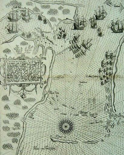
Figure 6: 1607 Map (Source: NLB)
The 1607 map of de Bry stands out for depicting not only the geographical layout of Singapore Strait but also navigational hazards and political conflicts. The inclusion of features like ‘Sinca Pora (i.e. Singapore), “Straet van Sinca Pore (Straits of Singapore) and Valsch Sinca Pore (False Straits of Singapore) reflects the complexity of navigating these waters. Moreover, the map depicts the Dutch-Portuguese naval confrontation in October 1603, marking a significant event in Southeast Asian maritime history. This confrontation highlights the region’s strategic importance as a battleground for colonial powers, with Singapore and Johor Lama serving as critical nodes in regional alliances. The map’s showcase of
the naval vessels, navigational depths and environmental hazards illustrates the technical precision needed by these ships to navigate the waters. This offers early evidence of Singapore’s significance, not just in trade routes but as a political flashpoint in European colonial rivalries. (See Figure 6)

Figure 7: Straat Sincapura Map in 1650 (Source: NLB) Straat Sincapura Map (c.1650) further emphasises the environmental changes in the strait by focusing on environmental and bathymetric data to show geographical challenges and navigational routes. (See Figure 7)
Together, these maps demonstrate how Singapore’s maritime relevance extended beyond trade by showing the technical, environmental, and geopolitical dynamics that shaped its development.
Urban and Conservation Planning
By the 19th century, as European dominance solidified, attention shifted from navigating the seas to controlling land-based resources. This transition would not only mark the rise and fall of British influence but also how such changes would show the power of land over sea.
While the legend of Sang Nila Utama provides an early indigenous (albeit mythical) narrative about Singapore’s origins, colonial historiography have shaped the nation’s planning, with the most well-known figure being Sir Stamford Raffles and the Jackson Plan of 1822 12

Figure 8: Raffles Town Plan (Source: NLB)
As a proposed scheme, the main aim of the plan was to maintain the order of Singapore as a colony founded in 1819. Unfortunately, this plan was never executed properly but it served and showed us a guide for how Singapore was supposed to be developed, including in conservation efforts today. Additionally, the infrastructure for maritime activities, including the harbours, rivers and piers especially, were established with direct connections to ethnic enclaves like the Johnston’s Pier (predecessor to Clifford Pier and demolished in 1970) was situated in the heart of Chinatown and catered to Chinese trading activities. (See Figure 8)
12 Tan, B (n d ) Raffles Town Plan (Jackson Plan) National Library Board Singapore https://wwwnlb govsg/main/article-detail?cmsuuid=ed0c1981-882f-42c2-9acf-e5dae577a3ba
World War II was arguably the turning point for land-based dominance. Not only in terms of how spaces were utilised but also determining who controlled the land. The fall of Singapore in 1942 put the vulnerabilities of the island’s coastal defences on full display. This included the British destroying the Johor-Singapore Causeway, which made the Japanese navigate the Johor Strait using makeshift methods, including small jetties like the Sembawang Jetty and swiftly focus on advancing through the jungle terrain. This target on land-based transportation systems was especially evident in the 1942 Tokyo Nichinichi Shimbunsha map.13

The map does highlight maritime areas like the naval bases in Sembawang and minefields in nearby waters (See Figure 9). However, the largest area marked in red belongs to the transportation networks like the railway line from Malaysia. Even the forests and hills that used to cover Singapore were clearly depicted with different tree symbols. If terrain and infrastructure influenced Japanese military
13 National Heritage Board Singapore (n d ) Japanese map of Singapore Changi Chapel and Museum https://wwwnhb govsg/changichapelmuseum/collection/artefact-highlights/japanese-map-of-singapore
Figure 9: Tokyo Nichinichi Shimbunsha Map (Source: National Heritage Board)
strategy, their dominance in Singapore would also have to be based on land. Maritime spaces were used tactically rather than strategically, diminishing their long-term significance in favour of land-based systems.
Land took on even more economical prominence over the sea with the year 1964.14
Not only was that the year before independence from Malaysia, but the Singapore Tourist Promotion Board (STPB) needed to promote Singapore as a tourist destination to set itself apart from the country it was going to leave. This marked the beginning of an official shift towards viewing heritage as a commodity to attract global tourists. 14

Figure 10: 1965 Maps by STPB for Tours (Source: Singapore Tourism Board)
By 1984, the Tourism Task Force had been set up to look into how to boost tourism in Singapore. As such, tourism solidified its position as a product/commodity by 1986 with the development of the Tourism Product Development Plan aimed at revitalising historic districts (See Figure 10). Thus, a Civic and Cultural District Master Plan Exhibition was held to bring out the distinctive historical qualities of the area and enhance its relationship with Orchard Road, Marina Bay and the
Singapore River by 1989. Orchard Road in particular naturally transformed into a commercial area as it was already surrounded by several businesses that would benefit massively from the building of the North-South MRT line stations (Orchard, Somerset, and Dhoby Ghaut stations).
Unfortunately, the Singapore River and Marina Bay had to be reimagined not as hubs of trade but as curated tourist attractions. Since the river clean-up campaign in 1983, bumboats15 that were once essential for transporting goods are now ferrying passengers along the Singapore River for sightseeing and pleasure rides.

This mere delegation to river-taxis by licensed operators who pickup and disembark at Boat Quay and Clarke Quay reflects the transition of a working waterway into a leisure-oriented experience. Meanwhile as seen in the 1988 map,
15 Cornelius, V, & National Library Board Singapore (n d ) Bumboats National Library Board Singapore https://wwwnlb govsg/main/article-detail?cmsuuid=6d2b5d54-beeb-4c12-9e2b-a261a251dfc9
Figure 11: Bumboats (Source: NLB)
land areas were carefully planned. This includes the rise of the MRT stations in 198716 that soon became essential transportation systems to navigate around the country as seen in the expanding networks. Thus, water spaces are retained only insofar as they complemented the urban development.17

Figure 12: 1988 Map of Singapore with the new MRT Stations (Source: Singapore Land Authority)
Overall Analysis
Hence, these maps stress on Singapore’s geographic position being essential to maritime navigation and global trade. This significance is reflected not only in colonial ambitions but also in the technical and environmental aspects crucial for navigation.
16 Ho, S , & National Library Board Singapore (n d ) Mass Rapid Transit (MRT) system National Library Board Singapore https://wwwnlb govsg/main/article-detail?cmsuuid=319cadae-e684-41bc-b7b6-3bd4b06437d2
17 Singapore Land Authority (n d ) OneMap | Historical map gallery https://wwwonemap govsg/historicalmaps/#
The maps support the thesis by demonstrating Singapore’ historic maritime role, justifying the need for maritime heritage conservation. They show that Singapore’s development was directly tied to its strategic location in maritime routes.
Conservation efforts therefore should make use of this navigational data and infrastructure that formed the foundation of Singapore’s identity as a major port. However, these maps reflect colonial and Eurocentric perspectives, focusing on European trade ambitions and navigational needs while sidelining indigenous maritime practices. The documentation is thus limited in acknowledging local contributions to maritime history. The thesis thus emphasises a more inclusive conservation strategy to recognise both colonial and local narratives. Additionally, the thesis will include the conservation of intangible heritage alongside physical infrastructure, bridging the gap between traditional practices and modern conservation.
Chapter 2.4: Main Causes
The shift towards land-based development in Singapore reflects the prioritisation of urban growth over the conservation of maritime heritage. This has led to policy gaps that neglect the integration of maritime spaces into contemporary conservation strategies. Additionally, there is a significant generational and cultural disengagement from maritime heritage sites and in the policies. The assumption that community involvement alone is sufficient for sustaining heritage overlooks the need for targeted outreach and education initiatives to foster a deeper appreciation for Singapore’ maritime history. Together, these factors uncovered via
this literature review underscore the urgent need for a more inclusive approach to maritime heritage conservation.
Chapter 3: Methodology
Chapter 3.1: Ethnographic Frameworks
Having identified the main potential causes, the methodology needs to go beyond the literature review with key research questions based on research gaps. Hence, these research gaps are derived from several ethnographic frameworks and highlighted in corresponding colours within Table A in Appendix A.
By linking any information deemed inadequate or missing to the issues, each research question can then be rooted in specific areas that need to be addressed. Key frameworks include Spradley’s 9 dimensions, AEIOU, Sotirin, and POSTA.
Spradley’s 9 dimensions
Spradley’s 9 dimensions is a framework used to analyse and understand cultural settings. These dimensions can provide a structured way to break down and interpret various aspects of human interaction and behaviour within the maritime spaces as shown below;
1) Space: The physical layout or setting where cultural activities take place. Key places include the following highlighted in blue and shown in Table A.
2) Actors: The people involved in the maritime spaces. Singapore has two main commercial port terminal operators, namely PSA Corporation Limited and Jurong Port. PSA Corporation Limited manages the major share of container handling in Singapore while Jurong Port Pte Ltd is Singapore’s main bulk and conventional cargo terminal operator.
Most of the users of the spaces are varied so it would be good to capture them in site observations.18
3) Activities: Most of these areas are able to support a wide range of activities to be studied in site observations. This includes transport, shipping, recreational boating, and fishing. In particular, the modern recreational uses like leisure boating and fine dining are highlighting the shift from purely industrial use to mixed-use areas. Sembawang/Mata Jetty has to be highlighted here as the jetty illustrates and reflects the natural abundance of wildlife in the area through its simple layout, fostering connections among various fishing groups and hobbyists during communal activities like crabbing and fishing. Other historically significant maritime sites like Lim Chu Kang Pier have been abandoned and fenced off due to not being as accessible as Sembawang Jetty. This dual role as a natural site and a recreational hub highlights its continued relevance in modern Singapore, bridging the past and present through a shared appreciation of history and the natural environment across generations. However, its historical areas like the Beaulieu House19 are mostly known only for its adaptive reuse as a restaurant.
4) Objects: Most maritime spaces can accommodate various types of vessels, with harbours in particular being on a large enough scale to take container ships, bulk carriers, cargo freighters, coasters and lighters.
18 Maritime & Port Authority of Singapore (MPA) (n d ) Terminals https://wwwmpa govsg/port-marine-ops/operations/port-infrastructure/terminals
19 National Heritage Board Singapore (n d ) Beaulieu House Roots https://wwwroots govsg/places/places-landing/Places/landmarks/Sembawang-Heritage-Trail/Beaulieu-House
Additionally, there are various physical items that signify the cultural and historical significance of these areas. Notable relics include the iconic red lamps at Clifford Pier. In fact, due to how many symbols are present at the site, Clifford Pier has been chosen as one of the sites to investigate. This blend of functional and symbolic objects show how intertwined the community’s identity is with the maritime landscape.
5) Acts: The smaller units of activities or individual actions. Everyday acts include loading and unloading cargo, maintaining vessels, fishing, and recreational activities.
6) Events: Pertinent events in these spaces include their establishment and continuous expansion or closure. Based on the literature review, the development of Keppel Harbour in the 19th century is a notable event to be investigated.
7) Goals: The primary goals of Singapore’s maritime sector includes maintaining its status as a leading global port, promoting sustainability in maritime activities and integrating heritage conservation with modern economic needs. On a cultural level though, Singapore only sees the buildings most related to the country and/or can promote tourism.
8) Feelings: The emotional responses people have toward space and their experiences. However, these feelings need to be better articulated and hence checked into to see how to elaborate on people’s experiences with maritime heritage spaces.
9) Time: Time of course influences the space as seen with the evolution of not just the map but also the conservation policies that continued to only focus on specific physical structures meant to promote Singapore.
AEIOU Framework
The AEIOU framework complements Spradley’s 9 dimensions, where we focus on the interactions and environment traits described as the activities, users and objects have been covered already.
1) Environment: The environment surrounding these maritime spaces plays a crucial role in shaping user experiences and interactions. In Singapore, the retention of the island typology is increasingly challenging as the nation’s focus shifts towards land-based technological advancements that are more easily accessible to the general public. All because of the privatisation of land. Privatisation can create a scenario where commercial interests take precedence over heritage considerations, thus transforming spaces like Clifford Pier into the Fullerton Hotel20 as an exclusive dining and leisure destination that cater more to tourists than to local communities. In contrast though, shophouses inland are more accessible to the public, with the five-foot way being an arcaded covered walk that runs along the front of almost all commercial shophouses, even offering shelter from the effects of the weather 21 The difference in these zones add to a growing disconnect,
20 National Heritage Board Singapore (n d ) Transforming Clifford Pier building and customs house: The Fullerton Heritage Roots https://wwwroots govsg/stories-landing/stories/transforming-clifford-pier-building-and-customs-house-the-fullerton-heri tage/story
21 National Heritage Board Singapore (n d ) The “five-foot way ” of a shophouse Roots https://wwwroots govsg/Collection-Landing/listing/1015185
unless similar focal points are added to draw more public attention to the maritime areas.
Moreover, these types of structures are under threat due to constant exposure to waves and storms causing erosion and structural damages, as well as rising sea levels due to global warming and pollution making these environments less friendly.
2) Interactions: The blend of historical continuity and modern adaptation within maritime spaces is something to be observed more. Sembawang Jetty preserves its social role as a fishing spot and maritime viewpoint, continuing its use since the 1900s.
POSTA
The third framework is POSTA which helps organise observations in design fields. The acronym stands for People, Objects, Situation, Time, and Activities. Here, this study focuses on Situation specifically
1) Situation: This component refers to the context or setting in which certain behaviours, actions or practices take place. In the case of Singapore’s maritime heritage, this refers to both physical spaces and social-cultural elements where this heritage manifests. In contemporary Singapore, young Singaporeans need tangible, accessible focal points to connect with the historical maritime narrative. Yet, many existing cultural anchors, like plaques or maritime relics, are either ignored by the public or placed in areas that are not conducive to engagement. Traditional kelongs, which are
wooden offshore fishing platforms, could have served as one such focal point. Kelongs represent a direct connection to Singapore’s fishing past. However, most kelongs today are either privately owned, inaccessible, or have fallen into disuse. A compelling example is the kelong owned by Timothy Ng, located off Pulau Ubin.22 Pulau Ubin is considered out-of-the-way for the average Singaporean, being an island northeast of the mainland. With the lack of accessibility and decreasing need for the kelongs as fishing grounds, the kelong is going to cease operations due to financial difficulties. The Singapore Heritage Society (SHS) is actively petitioning to retain the kelongs as an educational and communal space but a feasibility study is needed to determine the cost and infrastructure needed for conservation. If kelongs like Timothy Ng’s could be conserved and repurposed as sustainable tourism or public education spaces, there could be a tangible connection into the fishing practices and communal life that was once integral to Singapore’s identity as an island nation. Already kelongs used to be part of learning journeys but most schools have stopped going there due to how far away the kelongs are.
Sotirin Framework
Finally, the Sotirin framework in particular is aimed at uncovering the complexities and richness of human experiences and relationships. Key aspects include Territory, People, Stuff and Talk. In this case, Sotirin makes use of the Territory and Talk dimensions. Singapore’s maritime spaces have long been divided along both physical and social lines. The Singapore River itself was segmented into different
22 Gene, N K (2024, September 1) Fate of one of Singapore’s last kelongs hangs in the balance The Straits Times https://wwwstraitstimes com/singapore/fate-of-one-of-singapore-s-last-kelongs-hangs-in-the-balance
territories, with the Hokkiens near the river mouth at Boat Quay and the Teochews settling further upstream near Coleman Bridge. These territorial divisions were not just geographic in nature but also represented economic and social distinction within the river communities. Wealthier merchants and traders controlled the more profitable and accessible parts of the river while the poorer labourers lived and worked in overcrowded and often hazardous conditions further upstream or on the fringes of the back. Yet, these dialect groups intermingled in riverside conversations about trade and commerce during communal activities, albeit indirectly. The higher social strata would negotiate deals and the worker class would gossip on these trades. Cultural transmissions included storytellers who would recite oral history.
And then, imagine more displacements with the 1983 River Clean-Up campaign. Silence replaced the informal talks, and even the boats were changed to tourist ones. While there are some heritage tours that go around the river, these tours are still primarily for foreigners and not something the average Singaporean would want to go on.23
Chapter 3.2: Research Questions
After analysing the frameworks, the following research questions were formed;
● RESEARCH QUESTION 1 (Spradley's Feelings; Goals; All Framework’s Activities): How should educational institutions in Singapore incorporate more comprehensive maritime history programs to enhance Singaporeans’ understanding of these spaces in the nation's heritage?
23 Cornelius, V, & National Library Board Singapore (n d -b) Singapore river communities National Library Board Singapore https://wwwnlb govsg/main/article-detail?cmsuuid=b821c72a-9035-49e8-bcb7-a95bbd9443c9
The comparison between the frameworks suggests an educational gap, where current programs may not adequately address the importance of maritime heritage, particularly concerning younger Singaporeans. Certain historical facts are known but there is no emotional connection reinforced in such activities. There is a need for research on how to integrate maritime history more fully into educational curricula to bridge this gap.
● RESEARCH QUESTION 2 (Spradley's Goals, Actors): Should Singapore’s government implement stricter regulations on the redevelopment of historical jetties and harbours to balance economic growth with the conservation of maritime heritage?
There is a tension between the need to conserve historical jetties and harbours and the pressure to redevelop these areas for commercial purposes. This tension reflects a broader gap in policy and planning, where the balance between heritage conservation and economic development has yet to be clearly defined.
● RESEARCH QUESTION 3 (Spradley’s Activities; AEIOU User, Interactions; Sotirin’s Talk): This then leads us to our main research question: Singapore's harbours and jetties were central to its development as a maritime hub. Why, despite extensive conservation initiatives, has there been a decline in the conservation of these sites since the 1990s, particularly concerning engagement by Singaporeans?
The cross-examination amongst the frameworks highlight the lack of engagement and awareness among Singaporeans about the significance of jetties and harbours, despite conservation efforts. The specific activities and interactions (heritage walks, workshops, etc.) are mentioned, but there is a gap in understanding why these efforts have not fully reached or impacted Singaporeans, including how well-known they are.
Chapter 3.3: Interviews, Surveys, and Site Visits
In order to address these research questions, a mixed-method approach was employed.
Casual Interviews
While casual, the interviews were effective in supplementing the observations of the mindsets of the users of the maritime space. Participants were encouraged to share their thoughts on Singapore and lost activities. Specific objectives questions can be found in Appendix C.
To go beyond the notes is to draw meaningful insights. The process began by gathering raw data from the various activities like notes, photos and observation user activities. In this case, raw data is from behavioural data with the observation of users in the maritime space and participatory design data with the interview responses. This raw data is then transcribed and organised in a visual form (See Figure;

Figure 13: Analysing Participatory Data (Author’s own referenced from Frog) Next, data is grouped based on individual participants. Each participant’s thoughts and feedback are clustered to see common themes or recurring observations.24
From these clusters, the next step is to identify the ‘opportunity clusters’. These represent areas where unique insights or potential opportunities lie. Patterns within the clusters are then identified. This helps in understanding overarching trends or common viewpoints.
Finally, the insights are analysed based on a set of criteria. Here, it is the focus areas, design ideas, design principles and archetypes. This is the stage where to decide how participants’ perceptions align with the project’s goal.
24 Frog (2014, March 6) Bringing users into your process through participatory design [Slide show] SlideShare https://wwwslideshare net/slideshow/bringing-users-into-your-process-through-participatory-design/31975488#71
Site Observations
Along with the interviews came site observations, particularly at Clifford Pier, Keppel Harbour (viewed from Vivo City as unable to cross) and Sembawang Jetty via counting charts. Counting charts would provide an organised means of tracking public behaviour and interactions with the design elements featured in these spaces. The use of demographic coding and timeframes allows for a detailed understanding of site usage patterns. Furthermore, there are arrows to show relations between the observed demographics and their interactions. There are various demographic groups, categorised by presumed age and gender;
- Youth (0-20 years old): Yf(female) and Ym(male)
- Adult (21-60 years old): Af(female) and Am(male)
- Elderly (61 and above): Ef(female) and Em(male)
Design elements refer to the various physical elements. Common ones include;
1) Pathway
2) Benches
3) Viewing Platforms
4) Hotels/Residences
5) Grass
6) Boat
7) Infographics/Boards
Activities most notably observed in these spaces would be;
1) Resting
2) Photo-taking
3) Talking
4) Sightseeing
5) Smoking
6) Eating
7) Exercising
8) Caregiving (for kids, pets, elderly)
9) Passing by
10) Playing
11) Working
Observations were conducted over two time periods: one weekday and one weekend across three time slots;
- 8:00 AM - 12:00 PM
- 12:00 PM - 4:00 PM
- 4:00 PM - 6:00 PM
Therefore, there can be better understanding of how these spaces function and the diverse ways they are utilised by the public.
Surveys
After conducting the interviews as well as performing site analysis, a survey was done to evaluate the hypotheses and/or solutions. Essentially, the survey has the following aims;
- Find out which features impede the feelings of islandness even in the harbours/jetties
- Find out why they continue to come
The survey follows a multiple-choice structure with options derived from research and interview and some open-ended questions to be discussed in the results section later. The survey has to gather a few descriptive insights within the
open-ended questions, thus generating a word cloud of the different answers towards the question.
Chapter 4: Results
Chapter 4.1: Interview Results
Ten interviews were performed. Looking at the responses will give a basic background in terms of what extent is Singapore an island and how unique it is. This allows a table to be plotted that can determine if there is a correlation between the concept of ‘islandness’ and ‘uniqueness’. Through accounts, interviewees described their experiences of life in Singapore, with most choosing to strike a balance by saying Singapore is an island-city. However, when asked to elaborate, more urban terms popped up and were more related to landforms found in Singapore. This included finding out what architectural features in Singapore come to mind, like shophouses and HDBs. Even the most marine-related spaces were about the glitzy Marina Bay.
Moreover, most do not feel like there is a difference between the marine spaces in Singapore when prompted to think more about the jetties and harbours, deeming them boring and not as outstanding as the other forms of architecture.
When it came to talking about the natural environment however, the interviewee’s appreciation for wildlife in particular was prominent, most citing the sea view and breeze and how many fishes they could catch. Sembawang Jetty in particular was lauded for the various species found in its waters, including groupers.
As such, these clusters were formed;
● Nature: Appreciation of wildlife
● City: Appreciation of the city
● Residential: HDBs and other spaces
● Heritage (Land-based): Shophouses, monuments, etc.
● Heritage (Maritime-based): Piers, jetties, etc.
From these responses, it is clear that most of the urban developments that arrest attention are striking focal points that stand out due to scale and forms. Any perception of ‘islandness’ tends to be diluted by these developments but this could be an opportunity to make similar attractions that would direct the focus to maritime areas. As such, a great opportunity clusters comes from blending architectural highlights with marine-based attractions.
Some participants consistently downplay the uniqueness of marine spaces but emphasise their appreciation for the sea view. This indicates a second opportunity cluster for enhancing the visibility of maritime spaces via more compelling and focused attractions.
The overall pattern is about ease of viewing which then means the focus area would be to prioritise marine-based spaces with clear visibility and accessibility to historical and striking elements. Design ideas could be open spaces with principles rooted in nature and the built environment.
This approach not only strengthens the visibility of maritime heritage in these areas but also transforms them into dynamic focal points that celebrate the city and its historical depths.
Chapter 4.2: Site Observation Results
It is noted that arguably the most popular and common activity in these sites on both days was caregiving. Most were speaking in their native tongues for the locals, especially for those minding the elderly due to their elders preferring to speak in their respective dialects.
It is noted that the visibility of certain activities like talking were significantly less for privacy reasons but this caused the overall areas to be extremely quiet on weekdays especially. Weekends naturally saw more families coming to the areas but for the maritime areas located in the city like Clifford Pier especially, most of these groups would be passing by the area or just taking pictures. Nobody even bothered to look at the tiny plaque right at the Fullerton Hotel’s entrance.
Having refined the understanding of the problem to a higher degree of clarity with these observations, the problem is now specific to how Singapore’s identity as an island nation can be conserved and revitalised via the design of the maritime spaces and information hubs that engage the public.
These observations help check some aspects and/or proposed solutions within the answers for the survey
Chapter 4.3:
Survey Results
The sample size was eleven. Most respondents were 25-44 years old (45.5%) and are students (45.5%). Participants’ choices on what ruins the ‘islandness’ of a place indicate common beliefs on what differentiates an island. These include limited sea
views, absence of maritime elements and pollution being frequent responses. High ratings on nature and accessibility reinforce these traits are valued for enhancing connection to maritime heritage sites.
A common word chosen to describe most maritime heritage areas would be ‘Serene’. This is in line with their reasons for visiting maritime heritage spaces to relax in various ways like with photography. (See Figure 14) Any future engagement activities thus are similar in nature and are connected to nature. If so, any design solutions to improve awareness of the heritage value of these sites must be connected to nature. Already, there is an overwhelming lack of initiatives related to maritime heritage according to the survey, with 72.7% not encountering any programs that teach them about Singapore’s maritime heritage.

Overall, the survey results suggest that a stronger connection between the city’s nature and its maritime heritage could redefine how Singaporeans engage with its coastal spaces, increasing visibility of these spaces and being part of educational efforts.
Figure 14: Word Cloud (Source: WordArt)
Chapter 5: Discussion
Chapter 5.1: Maritime Heritage as the National Identity
The process of heritage involves the recognition of the sites. In the context of maritime heritage, that would involve significant maritime landscapes, structures and traditions. All of these aspects must then fit into a broad conservation framework. Key enablers to this act include governmental policies and local communities who advocate or make up the maritime heritage scene in Singapore. Meanwhile, drivers would be the increasing recognition of the importance of national identity with these maritime heritage areas. Thus, the tools employed in heritage-making as solutions would be educational initiatives, design elements for comfort, and technologies that enable better visualisation of the affected areas.
Chapter
5.2:
New Framework and Solutions
There should be a singular framework focused solely on maritime heritage that consolidates the current fragmented approaches used for conservation, education, and redevelopment. This framework can come from the merger of the Six Criteria for Conservation and the Heritage Banding Framework. Within the framework, there will also be solutions to boost whatever value or feature is considered lacking if the site wants to be considered as relevant to maritime heritage.
1) Policy and Legislation with Historic Value
- The survey data suggests that respondents value historical significance/community roles of maritime heritage. There is also greater desire for more informative heritage programmes and noted
the importance of maintaining elements like kelongs. Hence, there could be specific zones to regulate heritage programming and ensure the area remains authentic with its elements.
- These specific maritime zones will come from assessing the historic value to the sites connected to significant events, individuals, and groups. (eg., Cashin family’s role at Lim Chu Kang Pier)
2) Marine-Specific Criteria with Aesthetics value
- Participants for both the interview and the survey mentioned that the lack of maritime elements like fishing boats as factors that defract from the sense of authentic maritime atmosphere and if they only see city-based elements.
- To draw appreciation towards these seemingly mundane structures, there can be gamified mobile apps with the tasks to guide through these aspects such as Hidden SG creating a self-guided outdoor game that uses simple WhatsApp messages and an artificial intelligence chatbot to help people find the more hole-in-the-wall places.25
25 Lim, J (2023, October 24) New WhatsApp-based game highlights Singapore’s hidden gems The Straits Times https://wwwstraitstimes com/singapore/new-whatsapp-based-game-highlights-singapore-s-hidden-gems

Figure 15: HiddenSG’s creator Lim Yee Hung (Source: Straits Times)
3) Activities for Social and Communal Value
- There is a need to capture how certain communities like fishing groups, boaters, and local residents interact with and use these sites as places of identity, culture, and practices (eg., trade practices at Keppel Harbour)
- These spaces can remain relevant and accessible by designing interactive programs that foster engagement such as student projects and storytelling initiatives by the elderly
4) Maritime Surroundings for Group and Setting Value
- Assessing maritime heritage within clusters like connecting jetties to larger ecosystems such as fishing routes can be done via architectural ethnographic participatory drawings.
- Several respondents noted their experience of serene atmospheres so something not intrusive like virtual tours can maintain this serenity since there will be no need for speaking.
- As each person contributes a drawing or recalls a spot to be added, the interrelations between land and water-based features will be more obvious as people will actively have to recall important parts of the routes.
Chapter 6: Conclusion
In conclusion, this thesis has demonstrated that conserving Singapore’s maritime heritage spaces is about reinterpreting the nation’s natural identity. Through a more inclusive strategy, the research invites communities, educators and policymakers to reclaim the maritime identity. While the work is limited due to the small sample size of less than twenty, future works should figure out specific forms the design elements must take to naturally frame the maritime spaces that would encourage learning about the heritage of these areas. Like how the Merlion will be undergoing cleaning in December 2024, Singapore needs to remember to keep the maritime elements intact as our national and natural pride.
Bibliography
Centre for Liveable Cities (2016.). Urban Redevelopment: From Urban Squalor to Global City. CLC.
https://www.clc.gov.sg/research-publications/publications/urban-systems-studie s/view/urban-redevelopment-from-urban-squalor-to-global-city
Chan, C. K. Y., & Lee, K. K. W (2023). The AI generation gap: Are Gen Z students more interested in adopting generative AI such as ChatGPT in teaching and learning than their Gen X and millennial generation teachers? Smart Learning Environments. https://doi.org/10.1186/s40561-023-00269-3
Cornelius, V., & National Library Board Singapore. (n.d.). Bumboats. National Library Board Singapore.
https://www.nlb.gov.sg/main/article-detail?cmsuuid=6d2b5d54-beeb-4c12-9e2ba261a251dfc9
Cornelius, V., & National Library Board Singapore. (n.d.-b). Singapore river communities National Library Board Singapore.
https://www.nlb.gov.sg/main/article-detail?cmsuuid=b821c72a-9035-49e8-bcb7a95bbd9443c9
Dictionary.com | Meanings & Definitions of English Words. (2021). Harbor. https://www.dictionary.com/browse/harbor
Dictionary.com | Meanings & Definitions of English Words. (2021). Jetty. https://www.dictionary.com/browse/jetty#google_vignette
Dictionary.com | Meanings & Definitions of English Words. (2021). Pier.
https://www.dictionary.com/browse/pier
Frog. (2014, March 6). Bringing users into your process through participatory design [Slide show]. SlideShare.
https://www.slideshare.net/slideshow/bringing-users-into-your-process-through -participatory-design/31975488#71
Gene, N. K. (2024, September 1). Fate of one of Singapore’s last kelongs hangs in the balance. The Straits Times.
https://www.straitstimes.com/singapore/fate-of-one-of-singapore-s-last-kelongshangs-in-the-balance
Ho, S., & National Library Board Singapore. (n.d.). Mass Rapid Transit (MRT) system National Library Board Singapore.
https://www.nlb.gov.sg/main/article-detail?cmsuuid=319cadae-e684-41bc-b7b63bd4b06437d2
Johnson, H. (2018). Islands of design: Reshaping land, sea and space Area, 52(1). https://doi.org/10.1111/area.12477
Kong, L. (2011). Conserving the past, creating the future: Urban heritage in Singapore. URA. https://ink.library.smu.edu.sg/soss_research/2287/
Kong, L., & Yeoh, B. S. A. (1994). Urban Conservation in Singapore: A Survey of State Policies and Popular Attitudes. Urban Studies, 31(2), 247–265.
https://doi.org/10.1080/00420989420080231
Lim, J. (2023, October 24). New WhatsApp-based game highlights Singapore’s hidden gems. The Straits Times.
https://www.straitstimes.com/singapore/new-whatsapp-based-game-highlights-s ingapore-s-hidden-gems
Luk, Ying Xian (2021). Utilitarian Heritage: The Panopticon of Narratives behind Industrial Heritage Conservation in Singapore.
Maritime & Port Authority of Singapore (MPA). (n.d.). Terminals.
https://www.mpa.gov.sg/port-marine-ops/operations/port-infrastructure/termin als
National Heritage Board Singapore. (n.d.). Beaulieu House. Roots.
https://www.roots.gov.sg/places/places-landing/Places/landmarks/SembawangHeritage-Trail/Beaulieu-House
National Heritage Board Singapore. (n.d.). Japanese map of Singapore. Changi Chapel and Museum.
https://www.nhb.gov.sg/changichapelmuseum/collection/artefact-highlights/japa nese-map-of-singapore
National Heritage Board Singapore (n.d.). The “five-foot way” of a shophouse Roots. https://www.roots.gov.sg/Collection-Landing/listing/1015185
National Heritage Board Singapore. (n.d.). Transforming Clifford Pier building and customs house: The Fullerton Heritage. Roots.
https://www.roots.gov.sg/stories-landing/stories/transforming-clifford-pier-build ing-and-customs-house-the-fullerton-heritage/story
National Library Board Singapore. (n.d.). Early Maps of Singapore. https://biblioasia.nlb.gov.sg/vol-3/issue2/jul-2007/early-map-singapore/
National Library Board Singapore. (n.d.). Searching for Singapore in old maps and sea charts. https://biblioasia.nlb.gov.sg/vol-11/issue-1/apr-jun-2015/search-sg-old-map/
National University of Singapore, Department of Architecture (n.d.). AC5002: Dr. HO Puay Peng lecture slides.
Siti Noorhidayu, B. I. (2014). Preliminary study of Morphological and Genetic Diversity on Asian Green Mussel (Perna viridis) in Santubong, Sarawak.
https://core.ac.uk/download/301744603.pdf
Singapore Land Authority. (n.d.). OneMap | Historical map gallery. https://www.onemap.gov.sg/historicalmaps/#
Singapore Tourism Board. (1965). Map of Singapore: 1st edition. Omega.
Tan, B. (n.d.). Raffles Town Plan (Jackson Plan) National Library Board Singapore.
https://www.nlb.gov.sg/main/article-detail?cmsuuid=ed0c1981-882f-42c2-9acf-e 5dae577a3ba
Yong, Chun Yuan. (2016). Merlion. National Library Board Singapore.
https://www.nlb.gov.sg/main/article-detail?cmsuuid=f9c0fd6c-acfa-4eb0-8585-2a a155c1d74d
Appendices
Appendix A: Tables
Jetties: A structure that extends into the water, providing a landing place for boats and offering protection from waves and currents[18]
Harbours: Sheltered body of water where ships and boats can anchor safely, often equipped with facilities for loading, unloadings, and servicing vessels [19]
Piers: A raised platform built over water, typically used for docking boats, recreational activities, and sometimes as a fishing spot [20]
Others: What other water bodies make up the maritime heritage
- Bedok Jetty - Changi Point Ferry Terminal (Changi Jetty) - Former Royal Malaysian Navy
- Keppel Harbor - Tanjong Pagar Harbor - Serangoon Harbor - Sembawan g Shipyard: Dockyard
- Clifford Pier: Occupying the former landing point of Singapore’s forefathers - Singapore River - Kelongs: Offshore palisade fish traps that once "were once a common sight in
(RMN)
Jetty/ Woodlands
Waterfront
Jetty
- Labrador
Jetty
- Lim Chu
Kang Jetty
- Pulau Ubin
Jetty
- Punggol
Point Jetty
- Sembawa
ng/Mata
Jetty for security and US warships vs the commercia l Singapore’s waters until they started to die out in the 1960s because of declining fish stocks and, later, the advent of sea-based aquacultur e farms in the 1980s.".[21] There are some plans to turn them into chalets/ed ucational centres
Table A: The Different Types of Maritime Heritage Spaces observed
Appendix B: Counting Charts
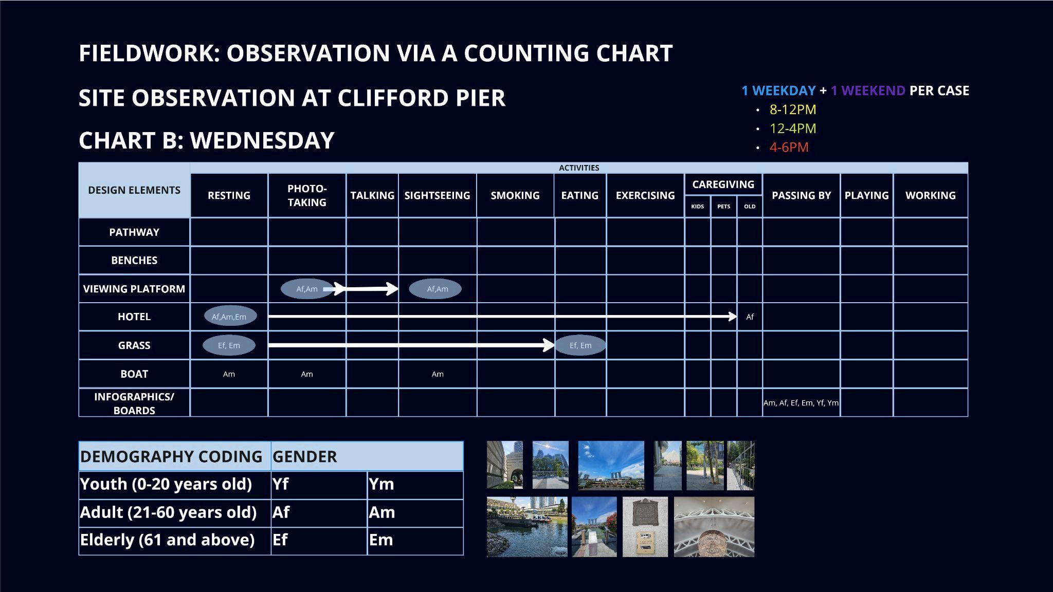


Appendix C: Interview Questions
- Findinding out how much of an island Singapore is to everyone: What do you think Singapore is in terms of geography?
- Gather all maritime features thought of (if any) and any lost activities: What do you think Singapore has in its maritime spaces? VS What do you think Singapore has in its architecture?
- Chart and see how often the overlaps are: Identifying patterns and trends across individual responses
Appendix D: Survey Results


