VERLAND O


DJIBOUTI | OVERLAND CAMPING | ECUADOR | MYANMAR


desert. Photo by Manu Torres


WE ARE ADVENTURERS Constantly traveling. Testing and using gear in real-world situations. Gaining experience, which we readily share.
7 continents | 161 countries | 496 years combined experience
WE ONLY KNOW THINGS WHEN WE LIVE THEM
PUBLISHER AND CHAIRMAN Scott Brady
PRESIDENT AND DIRECTOR OF DESIGN Stephanie Brady
CHIEF TECHNOLOGY OFFICER Christian Pelletier
CHIEF BUSINESS DEVELOPMENT OFFICER Brian McVickers
CHIEF FINANCIAL OFFICER Andre Racine
DIRECTOR OF EUROPEAN OPERATIONS Michael Brailey
EDITOR, OVERLAND JOURNAL Tena Overacker
CONSERVATION EDITOR Åsa Björklund
MEDICAL EDITOR Dr. Jon Solberg, MD, FAWM
ARCHAEOLOGY SENIOR EDITOR Bryon Bass, PhD
CAMP AND TRAILER SENIOR EDITOR Matt Swartz
CONTRIBUTING EDITORS Graeme Bell, Antonia BolingbrokeKent, M. John Fayhee, Fresh Off the Grid, Ashley Giordano, Sean Gorman, Dan Grec, Kira and Brendon Hak, Andrew Muse, Morgan Sjogren, Karin-Marijke Vis, Gary Wescott, Lisa Williams, James Young
SENIOR PHOTOGRAPHER Bruce Dorn
CONTRIBUTING PHOTOGRAPHERS Richard Giordano, Ivana and Manu Torres, Monika Wescott, Coen Wubbels
COPY EDITORS Arden Kysely, Jacques Laliberté
TECHNICAL EDITOR Chris Ramm
CARTOGRAPHER David Medeiros
PODCAST HOST Matthew Scott
PODCAST PRODUCER Paula Burr
VIDEO DIRECTOR Ryan Keegan
CONTACT
Overland Journal, 3035 N Tarra Ave, #1, Prescott, AZ 86301 service@overlandjournal.com, editor@overlandjournal.com, advertising@overlandjournal.com, 928-777-8567
MOVING?
Send address changes to service@overlandjournal.com. Include complete old address as well as new address. Allow two to four weeks for the change to become effective.Overland Journal is not forwarded by the US Postal Service. It is the subscriber’s responsibility to inform Overland Journal of an address change.
Overland Journal is a trademark of Overland International, Inc. All rights reserved. Reproduction in whole or in part without written permission is prohibited. Overland Journal is a wholly owned subsidiary of Overland International.
We carefully screen all contributors to ensure they are independent and impartial. We never have and never will accept advertorial, and we do not allow advertising to influence our product or destination reviews.


What better place to peruse the 2020 Gear Guide than on a National Police of Colombia patrol boat. After a week of team and skill-building with the carabineros, some of us took a quick trip to the Amazon—what an amazing place filled with great people and culture.
When home in New Mexico, I travel the Southwest in my in-progress restoration of a 1984 Chevrolet K5 Blazer—mostly stock—sporting a 6.2 NA diesel and TH400. Love your magazine and the inspiration of adventure.
Mike Gardiner
1984 Chevrolet K5 Blazer
IʼLL TAKE YOU THERE
Your publication is terrific! Your contributors are exceptional as well. It’s fun for me


to be able to travel in their stories to places I’ll never go and have never been. A good writer can transport you to such places—a wonderful talent.
Alan Ardizone
I am a professional adventure and nature photographer/writer in Moab, Utah. I’ve been an avid (some would say rabid) reader of Overland Journal since stumbling upon the magazine stashed in a rooftop tent atop a display vehicle at Easter Jeep Safari here in Moab around 2008. The incredibly high quality of both the writing and photography is consistent from issue to issue and it’s one of only three magazines I collect rather than discarding when I’m done reading.
Bret Edge
2021 Ford F-250 Tremor
ROW 1
@thelishen
Of the many things I’m looking forward to in 2021, cooking for our friends, family, and many of the brands we’re lucky enough to share the backcountry with is top of the list. This photo is from a rather delicious afternoon spent in South Carolina with the amazing crew from @dometic.
@pitcairnoverland
Showtime. #SunsetSky#CampingCollective
@lillitogo
Why a Toyota Landcruiser again? And such an old one? When we came from Africa to Australia, we needed a car for my partner’s work. After finishing his job, he wanted to travel to the Cape York Peninsula in the far tropical north [on] tracks which are challenging and remote. So a 4x4 was on our wish list.
ROW 2
@bugsonmyface
Anything goes on the salt flats.
@onewaynorthnz
In desperate need of some Landy weekend adventures.
@overland_blazer
See “The Journal Visits the Amazon” letter below.
ROW 3
@gil510
Shiftpod2 is the choice I went with over a rooftop tent. It’s more insulated, sets up in 30 seconds, weighs less, no wind noise, and has air-conditioning ports (Burning Man ready). Best of all, better for a baby.
@dadvan_overland
Don’t scratch the...! Ahh, do whatever you want; we’re camping, and I’d do anything to see you smile.
@pikipiki_overland_blog
For something different, five good mates undertook this off-road ADV moto trip in 2007 on the Angolan coast. It turned into a proper epic. The beach part can only be traversed at low tide; we didn’t. It’s not a place you get rescued fast or at all. This was before Inreach and Spot. No fancy overengineered luggage or such gear—just simple kit and [it] worked.
SHARE
Use #overlandjournal on Instagram or Facebook.
WHERE HAS YOUR OVERLAND JOURNAL BEEN?
Send us a photo, along with your name, the location, make/year of your vehicle, and a brief description. editor@overlandjournal.com


Dan Grec is an adventurer, snowboarder, and photographer who now hails from Whitehorse, Yukon, Canada. Growing up in Australia, family camping trips gave Dan a passion for wilderness exploration in remote destinations. After studying and working as a software engineer, Dan went in search of a more vibrant life. Eventually driving 40,000 miles from Alaska to Argentina, he became inspired by the characters he met along the way and is now dedicated to helping others realize their own overland dreams. To this end, Dan created and maintains WikiOverland—the community encyclopedia of overland travel. After years of planning and preparation, in early 2019, Dan completed a circumnavigation of the entire African continent in his Jeep Wrangler Rubicon.

Morgan Sjogren is a writer, adventurer, and former elite track athlete turned avid trail runner. Morgan has raced sprints on the track and ultramarathons in the mountains, yet she prefers using running as a vehicle to explore wild places, which she shares on her popular Instagram account. An avid activist, she roams the Southwest in her yellow Jeep Wrangler named Sunny. In her outdoor guide Outlandish: Fuel Your Epic, Morgan shows others how to embrace an off-pavement adventure lifestyle, with tips to explore more outside and recipes to fuel you along the way. Outlandish is now available in bookstores, running and outdoor shops, and online.

Gary and Monika Wescott have spent the last 45 years globetrotting around the world, from the arid desert of Turkmenistan, following the Silk Road, to the jungles of the Amazon, and across Siberia in the dead of winter. The couple’s travel adventures have been published in 10 countries and eight languages. Their in-depth knowledge of the problems and joys of overland travel in remote areas is incomparable. Gary and Monika’s meticulously prepared travel/research trucks, from their original Land Rover to the current Ford F-550, The Turtle V, have been an inspiration for many. Their experience and photography encompass what Overland Journal is all about. From the beginning, The Turtle Expedition’s motto has been, “Don’t take the trip. Let the trip take you.”

Brendon has been behind the wheel his entire life, his first solo expedition being at just six years old. No matter the season, you can find him outside, twisting a throttle or stomping a pedal. Kira’s passion has always been travel and photography. For her, capturing an image to share with the “inside” world has the power to change mindsets. Kira is certain she will travel to every corner of this beautiful planet and spark an interest in others to do the same. So the wanderer met the horse, and Adventure Haks was born—a platform to share their photography and tales of their journeys, with the goal to simply enjoy life and inspire others to get outside and explore.

Antonia Bolingbroke-Kent is a travel writer and broadcaster with a particular love of wandering alone through remote regions. The author of three books, she’s raised more than £60,000 for charitable causes and once held the highlycompetitive Guinness World Record for the longest-ever journey by auto-rickshaw. Her latest book, Land of the Dawn-lit Mountains, was Shortlisted for the 2018 Stanford’s Travel Book of the Year. Antonia writes for the Telegraph, Financial Times, Wanderlust, the Guardian, and Radio 4’s From Our Own Correspondent. Her first radio documentary was aired on BBC Radio 4 in early 2020. In 2019, she was the recipient of the Royal Geographical Society’s prestigious Neville Shulman Challenge Award. She used the grant from this award to fund her latest Naga expedition.

Freelance writer Karin-Marijke Vis, along with her partner, photographer Coen Wubbels, combine their love for adventure with work they enjoy. Sometimes described as being the “slowest overlanders in the world,” they believe in making connections and staying in a place long enough to do so. In 2003, the couple purchased an antique BJ45 Land Cruiser and began a three-year trip from their home in the Netherlands to Asia. Terminally infected by the overland bug, they traveled in South America for nine years, and in Japan and South Korea for two years. They are currently making their way through Russia and Central Asia. They’ve been published in magazines around the world, and in 2013, Expedition Portal awarded the pair the coveted Overlander of the Year award.


Ashley Giordano recently completed a 48,800-kilometer overland journey from Vancouver, Canada, to Buenos Aires, Argentina, with her husband, Richard, in their well-loved but antiquated Toyota Pickup. On the zigzag route south, she hiked craggy peaks in the Andes, discovered diverse cultures in 15 different countries, and indulged in spicy ceviche, Baja fish tacos, and Argentinian malbec. You can usually find Ashley buried in a pile of travel books, poring over maps, or researching wild medicinal plants. Ashley grew up in Kelowna, British Columbia, and spent much of her youth as a competitive figure skater. She worked as a paralegal for eight years while completing a diploma in holistic nutrition. She is currently studying herbal medicine with a focus on women’s health.

Raised in the mountains of Colorado, Sean Gorman was born to explore. After climbing the highest peaks in the US, he set his sights on guiding some of the world’s highest mountains. Sean’s first car, a 1961 Land Rover Series IIA that he still owns, became a tool that enabled him to develop his love for off-road exploration. He started his own business, combining the guiding skills from multi-month mountain expeditions and his zeal for offpavement, vehicle-based travel. Sean now consults on vehicle development and designs driving programs for automotive manufacturers. If you can’t find him in some remote corner of the world, you might find him piloting his vintage airplanes around the sky.

For 13 years, M. John Fayhee was the editor of the Mountain Gazette. A long-time contributor to Backpacker magazine, he has written for Canoe & Kayak, the High Country News, Family Camping, Walking Magazine, USA Today, Islands, Adventure Travel, and Men’s Fitness, among many others. Fayhee is the author of 10 books, including A Colorado Winter, Bottoms Up, and Smoke Signals, the latter of which was a Colorado Book Awards finalist. He has hiked the Appalachians, Colorado, Arizona, and Inca trails, as well as the Colorado section of the Continental Divide Trail. Fayhee lives in New Mexico’s Gila Country with his wife, who, despite ample cause over the course of 30-plus years, has yet to leave him.

Graeme Bell is a full-time overlander and author. He was born in Johannesburg, South Africa, but considers Europe home when not traveling the planet with his wife, Luisa, and two children, Keelan and Jessica, in a Land Rover Defender 130 (affectionately known as Mafuta). To date, the Bell family and Mafuta have over a period of seven years toured Southern and East Africa, circumnavigated South America, and driven from Argentina to Alaska before traversing the US from coast to coast. In December 2016, Graeme personally transformed their Defender from a standard double cab into a camper with through access, a pop-top, and sleeping for four in anticipation of their current adventure: driving from Europe to Southern Africa.

James is currently enjoying full-time travel with his wife, Claire. Their first taste of adventure was a yearlong around-the-world backpacking trip in 1994 when they were just 20 and 18 years old. Ten years later, they swapped England for the great outdoors, moving to British Columbia in Canada. Keen Ironman athletes, they grew weary of snow and began venturing south for training every winter, buying a 26-foot trailer to snowbird in San Diego’s RV parks. Feeling trapped by asphalt, they researched off-road campers, which led them to overlanding, which led to Claire demanding a truck camper, house sale, and adventure. They are currently traveling the world in Sherpa, a Ram 3500 and XPCamper, under the name This Big Road Trip.

Ivana, from Macedonia, and Manu Torres, from Spain, met in 2009 while working as beach vendors on Mykonos. They have spent more than 13 years traveling together. In 2011, they bought a 1970’s Royal Enfield Bullet in India and toured the country on their first motorcycle experience. Two years later, they decided to ride again, this time on a Yamaha Ténéré XT660. They crossed all the continents from end to end, until 69 countries and four and a half years later, Manu was diagnosed with bladder cancer. During the time that the surgery, treatment, and rehabilitation transpired, they prepared a Volkswagen T3 Syncro with which to continue exploring the world. Coming back to the road is the goal that encourages them every morning.

Megan McDuffie and Michael van Vliet are the couple behind the camp cooking blog Fresh Off the Grid. They’ve spent the past few years traveling around the country in their self-converted Ford Transit camper van. In the summer of 2019, the two got married in Yosemite National Park and hiked the 211-mile John Muir Trail for their honeymoon. They have since moved to Central Oregon, where they continue to develop and share delicious camping recipes. After taking a brief pause to ride out 2020, Megan and Michael look forward to exploring their new home base in the Pacific Northwest.

Andrew Muse is a full-time professional snowboard athlete and content creator for industryleading brands. He moved west from Massachusetts right after high school with only a couple hundred dollars to chase his dreams of living in the mountains. Andrew has taken some major leaps of faith toward some far-out dreams, which has led him to experiences he never imagined. After over a decade of living in a progression of vehicles, Andrew started a series called the Tiny Home Adventure, which is an action/adventure sports and travel series featuring life on the road with his dog and girlfriend. They are currently filming Season Three of Tiny Home Adventure in a self-built expedition vehicle called the MuseRoamer.

Lisa Williams is an Arizona native that spent much of her childhood exploring backroads with her family in whatever project vehicle her father was wrenching on at the time. She has traveled the continental United States by foot, by Ford Econoline, and most recently, by Jeep Cherokee. All her passions center around driving, connecting with nature, and a deep love for adventure. Though a practicing weekend warrioress, she aspires to write, photograph, and eventually rally race around the globe and share her journeys through photojournalism. Upcoming goals include competing in the Rebelle Rally, the Baja 1000, and an immersion into the less-traveled roads of New Zealand in her 2019 Toyota Tacoma.


Overland Journal is the original publication for environmentally responsible, worldwide vehicle-supported expedition and adventure travel.
SUBSCRIPTIONS AND BACK ISSUES
5 issues/year, online at overlandjournal.com or 3035 N Tarra Ave, #1, Prescott, AZ 86301
DOMESTIC & CANADA (USD)
1 year $45, 2 years $80, 3 years $112
EUROPE (EUR)
1 year €45, 2 years €80, 3 years €120
INTERNATIONAL (NON EU) (USD)
1 year $75, 2 years $140, 3 years $202
DIGITAL
Available on iTunes, Google Play, and the Zinio newsstand.


The nature of overlanding is continuously evolving, the definition expanding as the players, their methods, and motivations flex, driven by both autonomous and reliant factors. The industry is exploding as more newcomers join our ranks in droves, and vehicles and gear options continue to expand, albeit sometimes with a higher price tag than we’d prefer. I see these changes as primarily beneficial on all sides, though. Our equipment options continue to increase, and we have an opportunity to share our knowledge and the joy of overlanding. It also presents an occasion to explore new places as some of our favorites become more heavily trafficked, perhaps sending us more off the beaten path than we have ventured before. Everyone should be able to overland responsibly by their chosen mode.
We’ve also noticed some general discord in the community revolving around the use of expensive vehicles and equipment, as well as different viewpoints on where people should or should not go. What started as a brief reply to a subscriber on topic (see the letter below) became a little bit more. Our readers’ experience levels vary more than ever, and the balance between preaching to the choir and starting the conversation to those new to the congregation can be a tricky one—but it is a challenge we are up for.
LETTER FROM SUBSCRIBER:

I was appalled by the photo on pages 26-27 of the 2021 Gear Guide showing two brand-new tracks (presumably made by your authors) crossing pristine desert pavement in the high Andes. That Overland Journal, which presents itself as environmentally responsible, should glorify such unnecessary destruction is inexcusable.
Over the last few years, I’ve been seeing more and more of this type of thing in your magazine of taking snazzy vehicles where they do not belong. If that’s the direction that “overlanding” is going, then the activity is no longer distinguishable from the OHV crowds that have been trashing public lands for decades. The ultimate effect is the same.
Luke Evans 2008 Toyota Tacoma

EDITOR’S RESPONSE:
In this particular instance, the tracks pictured on the volcanic ash were already in place, and the expedition used the existing tracks to avoid further impact. However, to your point, though perfectly legal in an area where cross-country vehicle travel was permitted, why are there tracks in this location in the first place?
Adventure means different things to different people: some are drawn to far-flung destinations where the difficulty in getting there is half the reward, while some, either by preference or access to resources, may seek the less-traveled tracks closer to home. Both are forms of exploration and discovery and require environmental stewardship on our part.
One of the questions is where to draw the line, and as with most things, there are many opinions on the subject. If we liken this situation to a hiking trail where an offshoot has been started by users from the main track to a meandering river, do we take the alternate path to relax by the water for a moment? Or respect that it was not intended to be a thoroughfare? To take it means that even though we are not responsible for the original damage, we are contributing to the problem. No part of our planet has been spared from human impact, but our job is to lessen that impact whenever we can. Does that mean we shouldn’t climb Everest? Or use an existing track to go where few others have gone before? What about driving our vehicle to work or to the store when public transport is available, or we can make it on human power?
It is up to individuals to make their own choices. But our job as a magazine is to encourage responsible, ethical behavior whenever possible as it applies to the content we include. At the very least, we could have captioned the photo better to indicate these were not new tracks.
The photo brought to our attention is not unusual in that we sometimes feature remote and challenging destinations that require significant effort and equipment to reach. We do so to inspire the inner explorer in all of us. In this high-Andes journey, where 4WD vehicles were the chosen form of transport since the nearest supply stop was 160 miles away in an uncompromising environment, the group of travelers did their best to minimize new impact. No campfires were utilized, existing tracks were used whenever possible, and when forced to tread on never-stepped terrain in loose or solid rock surfaces, extreme care was taken. It is up to all of us to do our best to protect the fragile environments we visit. We will work to do even better as a publication to reinforce the greatest care of the cultures we encounter and the trails we travel.


HESTstands for “hostile environment survival tools,” and that is exactly what DPx Gear produces—knives that can survive the abuses of hard use in war zones, the backcountry, or even your garage. The HEST/F Urban titanium Mr. DP is a new take on their classic folding knife designed by Robert Young Pelton. It is manufactured in the US and features US-made sculpted titanium handle scales featuring the Mr. DP skull, a US-made CPM S35V stainless steel blade, stainless-steel caged ball-bearing pivots, and an impressive selection of other multipurpose features.
The frame-lock mechanism which secures the blade in its open position is rock solid and inspires confidence.
The blade measures just under 3 inches long and is sufficient for most hard-use cutting tasks. The .16-inch-thick blade stock is about twice as thick as any other similar-sized folding knife that I own, and I found it to be more adept at utility use versus delicate slicing tasks like food prep. The blade deployment is quick and snappy thanks to an oversized thumb stud and ball-bearing pivots, and the tension can be easily adjusted with a T8 bit. Its stone-washed appearance is handsome and doesn’t immediately show signs of wear. The frame-lock mechanism which secures the blade in its open position is rock solid and inspires confidence.
I would call the HEST/F a medium to small pocket knife; the grippy, comfortable titanium handle fit entirely within my average-sized hand. The folded knife easily fits in my pocket, but I would like to see a little more refinement of the pocket clip that occasionally grips my pocket too tightly for quick deployment.
The dual-purpose jimping/wire-stripping notches on the blade’s spine are a secure and appropriate place to rest my thumb for additional purchase when performing cutting tasks. I also appreciated the integrated bottle-opener/pot-holder that encouraged me to save the blade from attempting the potentially damaging task of opening a bottle. The integrated 1/4-inch hex socket does accept bits, but if inserted too firmly, they may require a pair of pliers to be removed. The only feature I was not able to test was the carbide glass-breaker on the base of the handle.
Although the pocket clip is reversible, the HEST/F is not offered in a true left-handed version, putting southpaws at a disadvantage for one-handed operation. While this isn’t a deal-breaker, at this price-point, I would like to at least have the option. The price of the HEST/F is steep, but its lifetime warranty combined with a tough-as-nails build ensures that this pocket knife is an investment that will last for decades.
$395 | DPXGEAR.COM

Tough as nails and built for a lifetime of use.

A comfortable option that consistently delivers, both inside and outside the vehicle.
Overland footwear is a piece of essential equipment often overlooked. We require footwear that allows precise control of the vehicle and is also supportive enough for when we are outside the vehicle working in rough terrain. Unfortunately, I often see people hop out of their expertly equipped vehicles in flip-flops or heavy mountaineering-style boots. I learned quickly as a guide on some of the world’s tallest peaks that proper footwear can make or break any expedition.
For most Americans, the Salewa brand name is one of obscurity, but its distribution is growing here in the States. Salewa was founded in Germany in the 1930s as a leather goods manufacturer that specialized in backpacks and soccer balls. In the 1950s, they pioneered mountaineering protective aides and have been focused on mountain sports since.
Shoe comfort is ultimately subjective, but after more than 700 days of use, I can say this boot consistently delivers.
I’ve been using Salewa footwear since 2007, when I wore a pair of mid-top trainers as my approach shoe for an Everest ascent. As usual, I donated that pair on my way down after the climb, but I wish I still had them. My current pair that I’ve been wearing the past few years are ideal for overland use.
The Mid GTX has the right mix of breathability, waterproofness, pedal feel, support, and most of all, they feel like slippers on my feet. The Gore-Tex membrane provides a waterproof barrier that lasts, yet the perforated leather and venting system offers enough airflow for the warmest of days. I wore these for four months in the Middle East, and the boots worked perfectly, but the small sand particles can get into the venting system, which can be irritating. I’d recommend a non-perforated boot for heavy sand work.
I have a narrow foot, and the included adjustable insoles allow you to custom tailor the shoe to your personal preference. The soles last a long time (and can be replaced), provide ample traction in the mud and snow, and offer an optimal compromise between pedal feel and foot protection. At 2.6 pounds for my size 13 boots, they are lightweight, but I wouldn’t put them into a lightweight category shoe.
Shoe comfort is ultimately subjective, but after more than 700 days of use, I can say this boot consistently delivers for me. The price is affordable, and the build quality top tier. I think about the things I’ve done in mine and look forward to seeing where they take me next.
$200 | SALEWA.COM
Go where the fish are in this inflatable kayak.

If you are overlanding near water, one of the healthiest and fun things you can do is fish for dinner every morning; it’s also a great way to save money. While casting a lure from shore can be productive, there is nothing like a boat to improve your catch. We spent a couple of weeks camping along the shores of Baja California’s Sea of Cortez and borrowed a Sea Eagle FastTrack Angler two-person inflatable kayak.
This multi-purpose craft sets up in less than 10 minutes, and thanks to its unique two-stage, double-action Bravo 4 pump, folding it up takes less time than it will to finish a cold drink. Its recommended inflation is a mere 3.2 psi. The adjustable seats are comfortable with tall backs and removable gear bags, and the two take-apart asymmetrical spoon-blade paddles with drip rings work
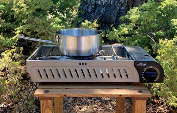
Don’t we all appreciate when a product serves more than one purpose? Kovea has hit that mark with the Dream Gas BBQ. While it is not the most compact stove on the market, it combines multiple functions for added convenience.
This butane-fueled barbecue also serves as a stove with a single burner tray sturdy enough to hold a pot of water or a large castiron frying pan. The mesh grill has built-in skewer bars that can hold several kabobs away from direct flame. The ceramic-coated steel drip plate has a drain plug to save juices from a long simmer
efficiently. Its removable skeg, in combination with its patented, external, rigid, inflatable NeedleKnife keel, is great for straight tracking and stability, even in wind and light waves or chop. A thick, EVA-foam-padded, removable floor prevents punctures from fish spines. Front and rear twin fishing rod holders and elastic tie-downs keep lightweight gear out of your way.
Made of reinforced 1100 Decitex, the hull weighs only 45 pounds with a weight capacity of three persons or 635 pounds. Its fold-up carrying bag is convenient for packing. Suitable for Class ll rapids, it can also be used with a 34-pound-thrust electric motor for trolling. (GW)
$1,629/DOUBLE, $1,349/SINGLE | SEAEAGLE.COM
An all-in-one product to increase convenience and functionality.
or help with clean-up. Additional features include an adjustment knob with auto-ignition and a Ushaped flame to improve heat distribution. The handled lid allows for checking on cooking progress while also keeping splatters in control.

The Dream has no wind shield, but I was able to create a barrier with storage bin lids on a windy evening so the flame would barbecue my marinated chicken. It is also noisy when stowed. If your vehicle is self-contained (no truck bed or external storage), you may have to buffer the noise as the included carrying case does little more than keep the parts in one place. The Dream would be a great addition to a pull-out-style kitchen or in a trailer kitchen setup. (LW) $200 | KOVEA.COM


A flexible, space-saving shoe that mimics the comfort of bare feet.
Xero shoes come from the natural movement school of thought, otherwise referred to as minimalist. The idea is that you need not put your feet in a cast of immobility (i.e., shoes structured with arch support or other orthotic notions) but instead achieve a footprint as close to barefoot as possible, strengthening your feet in the meantime.
For 10 years, Chacos have been my go-to trail sandal. The Z-Trails, in comparison, weigh just over 4 ounces each, half the weight of an average pair of Chacos, though you lose some of the sturdiness factor. On the flip side, they are flexible and can be rolled into a ball for packing, ideal for those on a moto or with limited space. Complete with a zero-drop heel, adjustable polyester webbing, and a 3-layer FeelLite sole comprised of BareFoam comfort, Trail Foam force protection, and Feel-True rubber grip pods, the Z-Trails hug the trail and work well in water.

The company offers a free exchange program if shoes are not the right fit—a good thing since I found the sizing chart to be inaccurate. I would recommend ordering a size up from what you normally wear.
While I’m not entirely ready to switch shoe camps, these would be a great alternative to flip-flops as they can take you more places without sacrificing space. (TO)
$80 | XEROSHOES.COM

The lightweight, minimalist travel kicks.
Learning to pack light feels half art, half psychology. Even after decades of veiled attempts, I am still miserable at it, ultimately bringing things I don’t need and leaving behind the essentials. Shoes have been particularly difficult, as they pack poorly and are often too heavy or specialized. But fortunately, over the past few years, minimalist shoes have become a genuine option, functioning better than ever before, and finally not looking like a circus accessory. Having tried several options, one of my favorites has become the Xero Shoes Mesa Trail trail runner.
At just over 7.6 ounces each, these units are extremely lightweight, and the lack of significant structure allows them to be rolled or flattened for improved packability. Being a trail runner, the sole has a sufficient (8.5-millimeter) lugged, dual-chevron tread pattern and a thin 3-millimeter foam layer to limit the possibility of footbed bruising from stones and roots. For travel, the Mesa Trail looks understated and works well in dry, warm conditions. These shoes have become my go-to for all motorcycle travel, comfortable after the moto boots come off, and still suitable for walking around local villages or during short hikes. My only complaint is the lack of similar models with waterproofing. (SB) $119 | XEROSHOES.COM

ASHLEY GIORDANO OVERLAND NEWS PHOTOGRAPHY BY RICHARD GIORDANO
The Rebelle

Theelectric vehicle revolution is here. Featured in Long Way Up to the Extreme E Challenge, electric vehicles are gaining popularity and exhibiting great potential. With countless automotive manufacturers announcing plans to build all-electric pickup trucks, such as Tesla’s Cybertruck, the GMC Hummer EV SUT, and Ford’s F-150 Electric, it’s an exciting time, ripe with innovation and possibilities. But one potential hang-up for the longterm overlander—and it is an important one—is the issue of range.
As overlanders, we pride ourselves on getting off the beaten track. We install long-range fuel tanks, strap extra gas cans to our vehicles, and calculate how far we can stretch those last liters of water or tins of food, all to explore hard-to-reach places along dirt roads or through difficult terrain. So how far away are we from using electric vehicles for long-term overlanding? What is the range really like in off-road conditions? Fortunately, a real-life proving ground for EVs exists in our own backyard—the Rebelle Rally.
Primarily taking place in the dusty, rock-strewn OHV areas of Nevada and California, the Rebelle Rally is an eight-day off-road navigation rally solely for women. Emphasizing precise navigation over speed, competitors use maps, compasses, and roadbooks to locate checkpoints strewn across 1,500 miles of the American West. From washboard gravel to Sierra Nevada mountain passes, cactispiked landscapes, and the golden curves of Southern California’s Imperial Sand Dunes, the terrain over which the rally takes place varies significantly.
Last year’s Rebelle marked the debut of the event’s Electrified Designation, which provided an opportunity for long-distance beta-testing of electric, plug-in hybrid electric, and hybrid vehicles navigating through remote locations. Two-time Rebelle winners Emme Hall and Rebecca Donaghe landed the pre-production Rivian R1T truck and were eager to put it to the test. They weren’t the only ones, as a team of Rivian engineers monitored the team’s progress remotely, analyzing velocity, efficiency, battery status, thermal data, suspension, and charge performance throughout the rally.
The 5,886-pound R1T is equipped with a 135-kilowatt-hour battery—one of two battery options that will be available to the public when the production truck is released in June 2021. According to Rivian, this mid-sized, 135-kilowatt-hour battery will crank out 300 miles of range, while the 105-kilowatt-hour battery should achieve approximately 250 miles of range per charge. The largest battery pack, boasting 180 kilowatt-hours and a range of 400 miles, will be available in January 2022.


Clockwise from top: The golden curves of Southern California’s Imperial Sand Dunes, just one of the terrain types over which the Rebelle roams. The pre-production Rivian truck averaged roughly 167 miles per charge. Hall and Donaghe’s view during the eight-day rally included the R1T configurable gauge display and an ever-changing view out the windshield. Don’t let the smile fool you. The competition requires fierce competitiveness and calculating strategy on the part of each team. To replenish the Rivian R1T’s charge during the rally, Hall and Donaghe rendezvoused with the Power Innovations Mobile Energy Command each afternoon.
So how close was the pre-production R1T’s actual range to that claimed by Rivian? Well, taking into account an additional 600 pounds of off-road gear (two spare wheels and tires, a floor jack, toolbox, spare parts, recovery gear, camping paraphernalia, etc.), and an enforced speed limit of 80 kph (50 mph), no climate control (Hall and Donaghe switched it off to optimize battery function), and punishing dirt roads through desert heat and soft sand, the R1T averaged roughly 167 miles per charge.
In her review for CNET, Hall, an automotive journalist, referred to the experience as a giant experiment. “First, this truck isn’t just pre-production, it’s extremely pre-production, and Rivian says the battery isn’t running at its complete capacity like it will be in customer vehicles. Also, keep in mind that off-roading is inherently awful for range.”
There are ways to maximize the R1T’s range, including tow charging and initiating the regenerative braking function. In one instance, Hall was able to feed up to 19 miles back into the battery by coasting downhill and tapping the brakes. Tow-charging could be an additional option for four-wheelers, Hall says. “You’ll never be out in the desert wheeling alone, right? If the truck runs out of juice, you can pull it behind another vehicle and pump some energy back into the battery.”
As there aren’t charging stations sprinkled across the Rebelle Rally course (yet), Hall and Donaghe charged the R1T via Power Innovations’ Mobile Energy Command (MEC): an 80,000-pound semitruck filled with six lead-acid batteries with 250 kilowatt-hours of power. “I was able to charge at speeds up to 130 kilowatts, which is almost three times as fast as most public charging stations,” Hall explains. Power Innovations intended to use a hydrogen fuel cell to keep the batteries charged during the rally, but a multitude of permits and a short timeline necessitated the use of a Tier 4 generator. “I’m the first to admit that using a generator to charge batteries that then charge an electric truck is far from ideal,” Hall says. “However, a Tier 4 generator complies with the strictest EPA standards, emitting less particulate matter and lower levels of nitrogen oxides.”
To replenish the R1T’s charge during the Rebelle Rally, Hall and Donaghe rendezvoused with the Mobile Energy Command each afternoon. “I simply drove up the semi’s ramp, plugged in, and 30 minutes or so later, the R1T was charged to about 80 percent,” Hall says. “At the end of each day at our camping location, I left the R1T connected to the MEC longer to get a mostly full charge—remember, batteries charge slower the fuller they are.” The final 20 percent took some time to charge, usually over an hour. The team couldn’t afford to lose this much time during the competition, so as a result, the R1T battery was at or below an 80 percent charge for the entire rally.
Although the Rebelle Rally is a proving ground for original equipment manufacturers, it also requires fierce competitiveness and a calculating strategy on the part of each team. For Hall and navigator Donaghe, that extra half hour it took to charge the R1T was a factor they had to consider when making time management decisions and strategizing for the rally. So as not to provide the team with an unfair advantage, event rules dictated that the pair would recoup the time spent charging at the end of the day unless Donaghe chose to plot checkpoints during that time. The extra time spent charging did use up precious daylight, however, putting the team at risk for arriving back at base camp after dark.
Navigator Donaghe says that one of the biggest challenges was plotting several extra points in order to track down the Mobile Energy Command each day. “Sometimes there were several points to plot, and then we had to decide which one we would take to exit or re-enter the course to get to the Power Innovations truck.” Donaghe had to make the choice early in the day and couldn’t alter her plans. “This was based on expected terrain ahead, the range we predicted to have left at exit, the time it would take to drive off and back onto the course (while racing sunlight), and where it intersected our planned course strategy—a matrix of deciding factors, so you had to plot them all to decide,” she says.
In addition to plotting points, Donaghe was constantly calculating and estimating the R1T’s range. “I would underestimate
how far we could go so that Emme was always able to make decisions as a driver,” says Donaghe. Hall weighed the pros and cons of making up time and how that would affect the battery. “My goal was to go as fast as legally possible between checkpoints to give Rebecca enough time to plot. But there were times where I had to slow down due to topography or to conserve energy,” she explains.
Despite the added challenges, Donaghe says she wouldn’t have traded the experience for the world. “I loved it. I loved every
RIVIAN HAS ANNOUNCED PLANS TO BUILD ITS RIVIAN ADVENTURE NETWORK, A WEB OF ELECTRIC VEHICLE CHARGING STATIONS AT ADVENTUROUS DESTINATIONS THROUGHOUT THE UNITED STATES.
minute of being in that vehicle.” With 826 pound-feet of torque, 754 horsepower, air suspension, and no flats after eight days on stock Pirelli Scorpion tires, Hall says the R1T was a “total champ” in tough terrain. Indeed, this R1T might even be the first electric truck to tackle the famed Oldsmobile Hill, an exhilarating 275-foot climb in the Imperial Sand Dunes.
Looking to the future, both Hall and Donaghe agree that the success of electric trucks and long-term travel relies on additional infrastructure—and it’s on its way. To coincide with the launch of its plug-in hybrid Wrangler 4xe, Jeep will install solar charging stations on 4WD tracks in California and Utah, including the renowned Rubicon Trail. Meanwhile, Rivian has announced plans to build its Rivian Adventure Network, a web of electric vehicle charging stations at adventurous destinations throughout the United States, outfitted with fast-chargers capable of adding 140 miles of range in 20 minutes.
The first drive-in fuel stations of the early 20th century transformed driving culture. Will improved electric vehicle infrastructure do the same? We’ll have to wait to find out.

SCOTT BRADY
Thelarge-displacement adventure motorcycle segment is a critical landscape for manufacturers, providing the financial margin and consumer excitement needed to sustain future opportunities in this rapidly changing market. Traditional superbike producers like Ducati have expanded their offerings to include scramblers and adventure models, all benefiting from the brand’s style and performance. The new Ducati Multistrada V4S, featuring their flagship Panigale V4 motor is their best adventure bike yet, and a solid shot across the Bavarian bow.
As a touring motorcycle, the new Multistrada is the most comfortable Ducati I have traveled on, combining the smoothness of the V4 with the upright riding position of an adventure bike. While the performance of the Ducati is to be expected, the touring attributes are worthy of notable praise, starting with the wind protection and windscreen. The windscreen lowers with a gloved hand and easily drops out of the way for off-road clearance. I was impressed with the lack of buffeting and low overall riding noise. Even the motor’s chorus would tame at cruising speeds. And on the subject of cruising, this is the first motorcycle I have tested with front and rear radar, which permits blindspot detection (with warning indicators in the mirrors) and forward-facing-adaptive cruise control. It would be easy to dismiss this feature, but it works perfectly and will nearly bring the bike to a stop, pacing the vehicle in front. The instrument screen is bright and easy to read, proving to be both intuitive and informative. The heated grips are more than adequate for cold climates, and complement the rider and pillion heated seats.
Off highway, this is the best Multistrada we have evaluated, combining a low weight of 480 pounds (when compared with most competitors), excellent Pirelli Scorpion Rally tires, and impressive damping characteristics. The first benefit I noted was the performance in sand, combining the flotation of the wide Pirellis with the low bike weight and good front/ rear balance—it rode in the sand like an 800. On technical climbs, the limited suspension travel was notable, and the traction control was all but unusable. Intervention was too high, even on the lowest settings, which cut the throttle or slowed the rear tire to the point that a failed hill climb was a real possibility. I solved the problem by just disabling TC, but it should be an easy fix for the engineers.
On the contrary, their dirt-tuned ABS was excellent and turned off the rear brakes completely. For larger events, the suspension tuning was impressive, even landing significant jumps on the trail. My only real concern in the dirt is the complete lack of a bash plate to protect that glorious motor.
$20,000 AND UP | DUCATI.COM

The Multistrada beats to its own drum, stronger than ever.
PROS
Shockingly good road performance
Improved dirt performance
36,000-mile valve train service interval
CONS
Traction control too invasive at lowest settings
No bash plate
Foot controls tight for larger boots


Exploring to the edge of the world in
By Dan Grec
a country like no other.

Iamalways on the lookout for new and interesting places but was struggling to find a safe way to visit and explore the horn of Africa. Somalia and Somaliland were not advantageous to this mean, especially unescorted in my vehicle. And the recent historic peace deal between Ethiopia and Eritrea has led to a strange state of affairs there.
After more than 20 years, the border is now completely open and free, allowing locals to reunite with long-lost family members. When it comes to a foreigner like me, nobody can tell me what will happen. The ambassador is happy to grant me a visa, but he doesn’t know if there will be anyone at the actual border to legally allow me entry. Meaning I will have to drive into Eritrea without obtaining an entrance stamp. It’s likely I will eventually be arrested for being in the country illegally, although there is no way to get the required stamp at land borders.
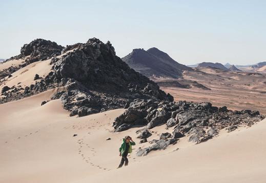
For those reasons, I begin to focus my efforts on the country of Djibouti, on the very tip of the horn. At 9,000 square miles and with only 885,000 inhabitants, Djibouti is tiny by African standards. As with most of the remote destinations

I like to explore, few outsiders visit this place, meaning that details are scarce, and once again, I’m setting out into the unknown.
Locals continually warn me of a massive protest and explain how the main highway from Ethiopia to Djibouti was blockaded just a day ago. The Ethiopian military has pulled out of the region, leaving the truckers that frequent the route feeling unsafe due to the presence of the quarrelsome Afar people in the area. The truckers have blockaded the road in protest, though I think it likely I’ll be able to squeeze by because I’m unconnected to all the problems. I keep my fingers crossed, and while there is evidence of where the road was cut, nobody is around to stop my progress.
Djibouti has three city-sized shipping ports that service landlocked Ethiopia, including a shiny new Chinese one that is apparently bigger than most cities. Everything Ethiopia needs to feed, clothe, and shelter its 100 million inhabitants is trucked over the immense mountain pass from Djibouti’s
shipping ports. I later learned that more than 2,000 overloaded transport trucks and tankers use this road each and every day of the year, and the volume of traffic and frantic driving is hard to believe.
As I drive deep into the rugged landscape, it begins to feel as if I’m farther from civilization than ever before. The landscape is shockingly empty and harsh, and I slowly climb up into rocky and dry mountains. In my sun-affected mind, daydreams unfold about driving to the edge of the planet as I know it.
After many hours in the scorching heat, I arrived at Ethiopian customs and set about waiting while the officials were away on lunch. As usual in Africa, it doesn’t matter what time I get to a border; everyone is always away on lunch. When the officials return, they carefully check all my paperwork and search inside the Jeep before the vehicle is officially stamped out of Ethiopia. I maneuver around at least 300 waiting transport trucks to locate immigration, where the friendly young officer is eager to hear what I think of Ethiopia, and more importantly, why in the world I’m visiting Djibouti. It’s extraor-


dinarily hot and barren, he says, and nobody chooses to go there. I’d like to find out for myself, I say.
Leaving the collection of small buildings behind, I drive into the wasteland that sits in the legal no-man’sland between the two countries. I have crossed a lot of borders and seen as many regions between countries, and this one takes the cake. The heat is intense on top of this lonely mountain pass. Dust billows in clouds from the relentless truck traffic, and not a single tree or shrub can be seen in any direction. Try as I might, I cannot spot any sign of life. The road surface deteriorates to severely cracked, broken, and potholed pavement, and I crawl forward in first gear—painfully, slowly.
Immediately, I’m thrown back into speaking only French as I set about obtaining an entrance stamp into what feels like the post-apocalyptic wasteland of so many movies. The dust seems to move in waves, and a thick layer coats every surface. Already my throat is scratchy, and my eyes are watering from the relentless, powder-like sand.
Djibouti Customs and Immigration stands as a lone outpost high in the unforgiving mountains. At customs, I’m issued a 10-day temporary import permit for the Jeep, and after I politely ask him, the official explains the permit can be extended if I wish. Of course, he has no idea how or where I might do that.
Through all of this waiting and stamping, the clock has been ticking, and it’s after 4:00 p.m. before I start what turns into a very long and exhausting drive down into Djibouti. Over the next five hours, I cover only 60 miles on what is the most broken and destroyed paved road I have ever experienced in all of Africa. I drive long past dusk and into the pitch dark, breaking my one cardinal rule of international overlanding.
The relentless trucks thundering on mean I’m constantly surrounded by thick walls of dust that reflect my headlights back into my face. Passing is intense, as I can’t see through the gritty clouds to determine if there is oncoming traffic. Evidently, a new road is, or rather was, under construction, and so at times, it’s faster to drive on the gravel construction than the old broken tarmac. This path is comprised of endless boulders and harsh corrugations, and while it makes for slightly faster progress, it’s also where all the truck traffic is concentrated.
At 9:00 p.m., I’m still 60 miles short of my destination of Djibouti City and too exhausted to continue. After arriving at the country’s first small town, I negotiated with a hotel manager to camp in the walled parking lot of his rundown establishment. Completely wiped out, I fall into bed with the thermometer still pushing 100°F, even though the sun has been down for hours. Despite the intense heat, sleep comes quickly.
In the morning, I continue down into Djibouti City and immediately fill up at a perfectly normal gas station. In stark contrast to neighboring Ethiopia, there are no gas or diesel shortages here, and I manage to feel happy about my full tank even with the outrageous price.
It feels like I’m wilting merely by being outside. The temperature hits 100°F by 10:00 a.m., and locals repeatedly remind me that this is actually winter in Djibouti—in summer, it will surely climb over 120°F every day.
After a short time in the city, I realize Djibouti is a very unusual country. Because of its location so close to the Middle East, Somalia, and Yemen (and the ongoing wars there), many countries’ militaries keep active bases here. They want to be strategically close in the event they need to deploy, and the weather and landscape of Djibouti also provide the perfect training environment. After only an hour in the city, I see US tanks driving on city streets, and uniformed military personnel from Japan, China, France, and the UK, to name a few.
I set about obtaining an entrance stamp into what feels like the post-apocalyptic wasteland of so many movies.
Because of the huge population of governmentemployed foreigners, everything is exceptionally pricey. Even a ramshackle hotel is $60 a night, the supermarket is triple the price of what I expect, and gas is the highest price I have ever paid in Africa. Development in Djibouti is also very atypical from what I have come to expect throughout Africa because of the strong Arab and Middle Eastern influence. Outlandish developments have sprung up in what otherwise appear to be impoverished neighborhoods, and brand-new Range Rovers and Porsche SUVs are a very common sight.
When I applied for my Ethiopian visa back in Kenya, I wanted a multiple-entry visa; specifically, so I could visit Djibouti and then return to Ethiopia. I was told multiple-entry visas are never issued to tourists, and so I used up my only entry when I entered Ethiopia from Kenya. Once in Addis Ababa, I tried to extend my visa into a multiple-entry one, though the head of immigration was very suspicious about my plans and indicated it might take two to four weeks to achieve my goal. In the end, I decided to wing it, and so I have driven into Djibouti with no legal way of returning to Ethiopia.
After locating a photocopier and a printer to organize all the required paperwork, I drive across the city


from top left: A tiny dirt track winds through small mountains towards Lake Abbe. My Jeep serves double-duty as a house on wheels and Martian explorer. Lake Abbe has a very high salt content and is the largest in a chain of six lakes fed by Ethiopia’s Awash River. Locals often travel the barren landscape by camel. Rock formations come to life in the fading light. Once kicked up, the thick, heavy dust coats every surface of my vehicle.


to the Ethiopian embassy, stressing about the fact that I’ll be stranded if I am refused a visa. The neighboring countries are a no-go, and while shipping out of Djibouti is possible, I’ve heard it is prohibitively expensive and would put an end to my African adventure. Unbeknownst to me, the country follows the Arabic tradition of Friday and Saturday being the observed weekend. As it happens, I have arrived on a Friday, so the embassy is closed, and I won’t be able to ask about a visa until Sunday. I have no say in the matter, and it means I will keep wondering for a few days where the adventure will take me next.
After a quiet night in the city, I retrace my tracks north before turning onto a dusty and rocky trail into the desert. For hour after hour, I crawl through the ever-changing landscape, feeling extremely insignificant and isolated. After eventually crossing a small mountain range late in the afternoon, I can just make out strange rock formations on the horizon, indicating my destination.
Lake Abbe is a little-known volcanic region in the far north of Djibouti, close to Ethiopia. The area is similar to Ethiopia’s famous Danakil Depression, and I’ve made a point to come here because virtually nobody visits, so I will avoid the hundreds of tourists I’m told make the journey to the Danakil every day.
Steam and hot water are forced to the surface near the lakeshore, and as they deposit minerals and calcium, the rock slowly builds upward, forming chimneys that are likely thousands of years old. The entire scene is desolate, scorchingly hot, and dusty beyond belief. Never before have I seen such a strange landscape; it’s as if I’ve driven my Jeep onto the surface of the moon—or better yet, Mars. Weaving through the bizarre rock columns in the Jeep while dodging hissing steam and boiling puddles of water, I can’t help but

think of the little Mars rover doing exactly the same. The scene is simply of another world.
After exploring until right before sunset, I happen across two young ladies herding their goats home for the night. They are dressed in gorgeous colors and proudly wear ornate gold jewelry. At first, they are shy, though they warm up and are happy to have their pictures taken after I ask permission. We don’t share any language, though, as usual, smiles and hand gestures are enough to convey our respective points.
The entire scene is desolate, scorchingly hot, and dusty beyond belief. Never before have I seen such a strange landscape, it’s as if I’ve driven my Jeep onto the surface of the moon—or better yet, Mars.
The goats kick up a thick dust cloud, and I can’t help but wonder how anyone is able to scratch out a living in this surreal and bleak landscape. I have not seen any semblance of a village or even a lone hut, and I’m in awe of the girls’ resilience as I watch them happily set off into the dying light.
Mercifully, the wind and temperature dropped in the evening, and I drift off to sleep with dreams of distant universes running through my mind.
I’m moving long before sunrise to take in the immense views as the last of the always impressive desert stars fade with the coming of the light. There is a pang of longing and familiarity when I spot the Southern Cross low in the sky just before dawn. Even this far north of the equator, it still makes a brief appearance and reminds me of my family on the other side of the earth in Australia. If not for this asterism, it would be easy to think I’m not on the same planet as them. I aim to continue north to Egypt, and I wonder for how much longer I will see the symbol of my homeland.
I poke in and around the various hot pools and steam vents and discover most are shockingly hot— very close to boiling, in fact—though I do find a couple that would be perfect for an early morning soak. In every direction, I see springs bubbling and hissing from the ground, and there is also the odd, perfectly transparent cold spring. Reluctantly, I begin the long drive back to civilization, still in disbelief at the microcosm I have visited.
One of the main reasons I was excited to visit Djibouti was the prospect of swimming with whale sharks, said to practically invade the bay at this time of year. I organize an outing with a local tour operator, and soon we load into a boat and begin scanning up and down the coast for the gentle giants from the deep.
I’m told things have changed in recent years. While their movements used to be regular as clockwork, the


whale sharks are not as predictable in their movements as they once were. The construction of the enormous Chinese shipping port on the city’s outskirts put massive plumes of silt in the water, which might explain their absence.
We scan for hours, though unfortunately, we don’t spot a single creature. I’m a little disappointed, but soon remember I could have visited an aquarium if I was desperate to see one. That holds zero interest for me, though, as I’d much rather see these leviathans in their natural habitat, wild and free. The chance rather than the certainty is what makes the possibility so exciting.
After lunch, I snorkel right from shore and am staggered by the reef and marine life. It’s easily as good as reefs I have seen in Australia, Panama, and Colombia, and it’s only a handful of yards from shore. There are many thousands of brightly colored fish and coral, and in the distant deep water, I see schools of larger fish lurking. The water is bathwater warm and clear, making the whole experience feel like a jaunt in a tropical paradise.
Around the bay from Djibouti City lies the bizarre Lake Assal. At 509 feet below sea level, this is the lowest point on the African continent and the third-lowest point on the earth. I’m shocked to see how close to the ocean it is, and it seems impossible the ocean water does not flood down to fill the lake. Evidently, the low mountains are enough to hold back the tide. The lake and the immediate area are again barren and scorched white due to the lake’s high salt content. Once more, I feel as if I’m exploring the moon and have somehow driven my Jeep off the planet I usually call home.
The lake is 10 times saltier than the nearby ocean, and salt is being commercially mined by creating thousands of shallow evaporation pools. Assal has an extremely buoyant property to its water, similar to the Dead Sea, though the prospect of being coated in crusty salt doesn’t appeal to me, so I don’t take a dip.
Back in Djibouti City, I return to the Ethiopian embassy, feeling more than a little nervous about the outcome. After speaking to many locals and driving within 10 miles of the Somaliland border, I still don’t like my options if I can’t get another Ethiopian visa.
Inside, I’m greeted warmly, and after explaining myself, the friendly man behind the counter asks me to wait. Ten minutes later, he asks for my passport and payment, and ten minutes later, he returns my passport, now with a new single-entry Ethiopian visa inside. As I have come to learn in Africa, stressing about something is not worth it. Like a rocking chair, it will give you something to do, but it doesn’t achieve anything.
Knowing I will be driving right back into massive shortages in Ethiopia, I fill everything I can carry with gas before leaving the city for the last time. I buy 31.5 gallons for 35,400 Djibouti francs, or $205. The official station price of $6.50 per gallon is easily the most expensive pump gas I have seen in all of Africa.
I psych myself up for the drive back and up over the horribly broken highway and clear the city early in the morning. The worst of the road is not nearly so bad during the day when I’m well-rested, and I’m at the still-scorching remote outpost that is the border soon after 2:00 p.m. Everyone at the border remembers me, and so the formalities are simple and straightforward when played in reverse. As usual, everyone is proud to hear I thoroughly enjoyed my time in their country and sincerely welcome me back. The familiar young officer at Ethiopian immigration barely glances at my new visa, and I wonder if I could have talked my way in without it.


The endless procession of dangerously overloaded transport trucks that traverse this crumbling highway takes their toll, both on the road surface and the drivers. I see multiple trucks that have crashed: some have gone off the side of the mountain, others are burnt out, and still others appear to have crashed into other vehicles. As always, it’s a somber reminder of the all-too-real consequences of careless driving.
After lucking out buying gas on the black market, I desperately want to avoid driving into the night again. I ask at the largest hotel in town if I can camp in the parking lot. After some back and forth, I set up camp in a great spot, and for a mere $5, have access to a shower, water to fill my drinking tank, and an onsite restaurant and bar. After seeing hundreds of beds outside with bug nets, it takes me a minute to realize what I’m looking at. This is clearly a very busy travel stopover for locals, who now begin to arrive on multiple busses—it’s the equivalent of Ethiopian overlanding, and I love it.
Never before have I visited landscapes alternately so stark and breathtaking, a reef so vibrant, and looked upon conditions so harsh and contrary to life.
Soon the restaurant is hopping with people, and virtually everyone visits my table to say hello and talk about my homeland. The local injera flatbread is fantastic here, and everyone laughs when I struggle to eat it with the seriously hot sauce that accompanies it.
I’ve been fortunate to explore many of the most remote regions of this stunning globe. From the Salar de Uyuni of Bolivia to the Arctic tundra of Alaska, the Kalahari Desert to the Congo Rainforest, I have seen and experienced many different landscapes and cultures. The more I have explored, the more I have found places begin to feel similar or even familiar. Mountains have the same majesty; lakes the same splendor; rivers, glaciers, deserts, cities, and farmland are usually reminiscent of those features in faraway countries or continents. Often I find myself thinking, “This looks like the lake district of Argentina,” or “This desert looks like Morocco.”
In the case of Djibouti, that was never the case. The diversity and unique natural beauty of this country stand alone and have no similar comparison. Never before have I visited landscapes alternately so stark and breathtaking, a reef so vibrant, and looked upon conditions so harsh and contrary to life. Defying belief, locals manage to not only survive but thrive in this most brutal of landscapes, and they do so with a smile. Time and time again, it felt as if I had driven off the planet I have explored so thoroughly, and I can honestly say that Djibouti is like no other place on Earth.


Portfolio by Ivana and Manu Torres 17-22°N


Imaginea place where pink river dolphins swim beneath you, birds of every size and color fly overhead, and monkeys glide through the air between the trees. In the same place, you’ll find dangers lurking around every corner: crocodiles, piranhas, and anacondas are waiting to greet you if you dare go for a swim. We reached such a place after a boat ride into the Amazon jungle, where we hired a local guide and his canoe to venture farther into the largest tropical rainforest on Earth.
It pays to be alert and on the lookout for activity—you never know what’s going to pop out here. Opposite top to bottom: As the sun sets, the jungle comes alive with a cacophony of animal calls. Brendon, securing the rainfly over our camp kitchen. Opening spread: The Amazon Basin contains a labyrinth of flooded passages.
Our adventure started with the usual scanning of the map. It became apparent that Ecuador has roads reaching into the Amazon Basin, with easier access than other countries. A Google search brought us to an article by Smithsonian Magazine online, and the first paragraph sealed the deal. “Deep in the heart of Ecuador’s Amazon Basin, in the shadows of the Andes and below the equator, lies what may be the most biologically diverse place on the planet. Yasuní National Park in eastern Ecuador is home to millions of species of plants, birds, insects, and mammals.” This vast area of land is also home to two uncontacted indigenous tribes. It was settled; we would drive to Coca then find our way into the park.
We found a suitable place to store our motorcycle, and early in the morning, made our way down to the bustling marina to set
sail for Nuevo Rocafuerte—approximately 200 kilometers down the Napo River. Once we’d settled into our seats amongst a crowd that overflowed onto the floor, Bren leaned down to whisper a wellthought-out evacuation plan that involved leaving our stuff, bypassing the horde by escaping through the windows, and swimming to the nearest shore. Though unlikely that the ferry would capsize on this eight-hour journey, having disaster plans are an important part of our adventure planning. It’s become standard procedure for us— an exercise in always being prepared.
The morning fog was just lifting and blanketed the trees on the riverbank. The transpiring notion of venturing to the distant region brought a chill of excitement and anticipation. We smiled as we watched the kids across from us take turns scarfing down their pail of chicken and rice—brothers, we presumed. Once finished, they draped a blanket over their heads and went to sleep, as did most of the passengers. Too exhilarated to sleep, we picked up our books and settled in for the long ride.
Toward the end of the passage, the ferry would pull up to various spots along the shore for families to unload: sometimes at small villages, other times at only a single wooden house on stilts tucked back into the jungle. The transport to and from the “mainland” is this shuttle, and at $18 one way, we can’t imagine it is a trip taken often. Most of the residents have dugout canoes with small motors for short distances, but that is all.
Upon reaching Nuevo Rocafuerte, the last small village on the river before the border with Peru, our mission was to find a local guide to take us into Yasuní National Park. Nuevo Rocafuerte was small enough that we could shop around for a guide in the late hours of the day. First, we were directed to Juan Carlos, and our first impression was that we couldn’t afford him. He had the air of a professional guide with nice clothes and a first-rate speech outlining his tour. Our presumption was correct. He directed us to another guide a short walk away. We were able to reach an agreement with Señor Luis Ramos; he would boat us into the jungle and make sure we didn’t eat anything poisonous or be eaten by anything in turn.
We arose effortlessly at 5:00 a.m. in anticipation of where the day would take us. It was only a short wait by the riverside before Luis came floating by in his narrow wooden canoe. We eagerly hopped on board, and the boat slowly motored down the Napo River through the morning fog and the rising sun. A kingfisher and a pair of green parrots simultaneously flew above us; we turned to smile at each other—this was it.
The tangled jungle looked stunning in the soft light. The only noise was the gentle rumble of the motor and the melody of birdsong. Luis gradually began to impart his wisdom, telling us about the area and its wildlife. We would soon learn that he was a seasoned expert in all things Amazon. Not only was he the first to point out anything that moved, but he could also mimic the animal calls.
We veered off of the Amazon’s largest tributary to sail the national boundary. The Yasuní River itself marks the border: Peru on the left, and Ecuador on the right. In Kichwa, Yasuní means Sacred Land, and pictures do no justice to the feeling of being there—the smells, sights, and the isolation. We were pulled out of our state of awe when Luis killed the motor and pointed out a troop of monkeys. We had seen monkeys before, but never like this. Forty white-front-


ed capuchins were in their natural habitat, soaring between the trees. We made an immediate correlation between the silence of the motor and wildlife spottings. During our second abrupt silence, we spotted pink river dolphins straightaway. As the pair of dolphins swam around us, we could see their translucent pink bodies break the water’s surface. They were small, the largest being only 1.5 meters (5 feet), with a long snout. And so swift that trying to catch a glimpse through the camera lens was virtually impossible.
We were able to reach an agreement with Señor Luis Ramos; he would boat us into the jungle and make sure we didn’t eat anything poisonous or be eaten by anything in turn.
Our plan was to camp in Laguna Jatuncocha and explore the surrounding areas by boat and on foot in the following days. Luis brought us to his usual spot, which was nothing more than a small clearing established on the shoreline. As we hung our hammock, Luis got to work with his machete, quickly erecting a picnic table and hanging some tarps for rain shelter. We watched his proficiency with interest and admiration. After our initial setup, we were only at camp to eat or sleep; the rest of the time was spent exploring. Back on the water, it felt like we were searching for lost tribes as we advanced into the narrow canals and flooded jungle passages that fed into the laguna. One question boiled in our minds, and we asked Luis if he ever gets lost in this labyrinth. His reply was, “No, only


Clockwise from top right: The goldenmantled tamarin is just one of the many species of monkeys we saw. Brendon and Luis, swimming off to find anacondas or perhaps serving as bait. Kira gazes upon the water as the boat heads toward some piranha fishing. Opposite: Luis led the way on our treks, always armed with his mighty machete.

twice.” It was hardly a comforting answer, but we decided to laugh it off and start paying very close attention to where we were going.
Over the course of our stay in Yasuní, we had the opportunity to undertake a handful of hikes. During the first, Luis saw fit to teach us basic survival in these parts, what he referred to as the liña de agua (line of water). Luis never packs water when heading out into the jungle. We watched him chop a 3-foot section of a thick, branchlike vine before proceeding to pour delicious, fresh water into our mouths. In addition, we learned about various edible plants, including a tree with little lemony pods containing a natural energy compound similar to caffeine.
Watching Luis in the jungle was a fascinating experience; he swung his machete around to clear the path, completely in tune with his surroundings. Occasionally he would stop and listen or make one of his many animal calls. Luis demonstrated his talents time and time again. We saw four species of monkeys on that hike: the goldenmantled tamarin, squirrel monkey, woolly monkey, and red howler. We also saw numerous birds, some of which he called right to us, like the blue-and-yellow macaw and the toucan.
After nightfall, Luis suggested we go out to look for caimans. It was a surreal experience to be far-flung in the Amazon in a small wooden canoe in the pitch-black night, with a lightning storm brew-
ing, searching for crocodiles. We ended up closing in on a few, but it was no easy task. There is a reason “deer in the headlights” is a saying and “crocodile in the flashlight beam” is not. We had to silently paddle for what seemed like forever to get right up close—enough time to rethink what we were doing. Finally, we were floating within a paddle’s length of a 4-meter (13-foot) black caiman. Then, as fast as the lightning flashed on the horizon, it thrashed itself into the water beside the boat. There was a breathless moment followed by a sigh of relief and a fit of laughter all around.
It was a surreal experience to be far-flung in the Amazon in a small wooden canoe in the pitch-black night, with a lightning storm brewing, searching for crocodiles.
The next day, following an extensive three-hour hike, we were on our way back to camp when the boat suddenly stopped. We spun around in search of another wildlife sighting only to find Luis getting ready for a swim. He said he was going to look for an anaconda, then jumped into the water. We had a single unspoken thought: he’s lost his mind. Then, rethinking the situation, Bren decided to hop in as well. If there was ever a time to go swimming in these waters, it was now, with his odds suddenly improved. Multiple factors would have ordinarily kept him out of the river, such as the fact that when you stick your hand in the water, it’s so murky you can’t see your fingers. Or the


crocodiles, anacondas, pacus, and various other residents lurking below the surface. Kira opted out since someone had to survive to tell the tale.
That evening, as we sat idle at camp, we decided to catch some bait for the following day’s fishing trip. We employed the use of a pot to capture minnows, then, in turn, used the minnows on a hand line to catch bigger-bait fish. Our technique was quickly put to shame when Luis came along and simply swung his machete into the water, decapitating the minnows where they swam. It was far more effective, and we got much more bait in the process. Utilizing the pot seemed silly in comparison. This guy was the real deal.
We listened as a mixture of sounds emanated from the jungle. Some of its inhabitants were seeing the day come to an end, while others were just getting started. As the sun dipped behind the trees, a calm feeling took hold—bliss.
Because there are very large fish in these waters (the largest being the pirarucu reaching 220 kilograms/485 pounds), we needed some rods to avoid losing a finger on a hand line. By smelling the bark, Luis selected a specific tree that he called the liña de caña, which can bend in half without breaking. We fastened a 5-foot length of fishing line and a medium-sized hook to each. We were all set to catch piranhas with lots of bait (fish and pork meat) and our handcrafted rods.
Once back in the tangle of mangroves and narrow channels, Luis taught us his strategy. You throw your bait into the water, then thrash the pole around to invoke a feeding frenzy. We sat back in the canoe and established our roles: we fed the fish, and Luis would catch them. Sometimes we could feel our lure being attacked violently, and other times the meat would be robbed without us noticing—at times, hook and all.
Slowly the giant pile of bait was consumed, and by the end, our hooks looked like they had been through a meat grinder. The metal was deeply gouged by sharp teeth. Thanks to Luis, though, we had dinner: two catfish and four piranhas. If it were only the two of us out there, we would have been better off just frying and eating the pork. The appearance of a giant river otter signaled our fishing trip was over; it was his turn to fish.
We ended our last day floating in the laguna for 45 minutes while watching the sun make its retreat beyond the horizon. Not one of us spoke a word. A ripple to our left revealed a pink river dolphin; a couple of squawking parrots flew overhead. In the distance, we saw something swim across the laguna, another otter, perhaps. We listened as a mixture of sounds emanated from the jungle. Some of its inhabitants were seeing the day come to an end, while others were just getting started. As the sun dipped behind the trees, a calm feeling took hold—bliss.
Our final sleep in the jungle was peaceful and undisturbed until we were suddenly jolted awake. Caimans hunt during the night, and the slap from their tail as they strike can be heard above all else. When they are 15 feet from your tent, the sound reverberates through your body like a crash of thunder. The only thing that enabled us to go back to sleep were Luis’ reassuring words, “Don’t worry, they don’t climb on land.”


Building the expedition vehicle of your dreams from the ground up.
By Andrew Muse

I’vealways been more interested in adventurous experiences than living luxuriously. I was raised in a rough situation in Massachusetts and moved to Utah just after high school in hopes of building a better life—not having been farther west than New York before. With next to no money to my name, I had to get creative to save funds for experiences and gear. I lived in the cheapest living situations I could find: sleeping in a sheet fort in a stairwell in a three-bedroom house with nine housemates, posting up in friends’ garages, living out of vehicles, and camping for extended periods of time. After years of living this way, I started making a little money and putting it aside. I decided I wanted to take a six-month road trip. I renovated a 1976 truck camper I found for $500 and set off with my first dog, Booter. We created 12 video episodes of our travels, which I called Tiny Home Adventure. Season One went off without a hitch until I finished filming the final episode and was headed back to Park City, Utah, to regroup. I was in a horrific car accident where I lost everything I had worked for. I barely escaped with my life, but my truck, belongings, home, life savings, and worst of all, my best friend, Booter, were gone. My life eventually came back together, but that’s a story for another day.
Fast-forward five years from the accident, and I’d just finished filming Season Two of the Tiny Home Adventure for GoPro in a built-out Ford E-350. Kicker (my new canine companion, who was eventually given to me by a firefighter from my accident) and I spent six months traveling through Alaska. At this point, I’d lived out of a progression of vehicles from an old VW Golf to a ChevyAstro van to the 1976 Dynacruiser to the Ford E-350. Now, I was looking to buy a home in Park City. After looking around for a few months, I quickly realized that there was nothing I could afford. Even a one-bedroom cabin deep in the woods without water was out of my price range. Instead, I decided to make my dream home on wheels manifest and live wherever I
wanted to. I’d been drooling over the EarthRoamer concept for years, but their wild price tag was far outside my budget as well. So, I decided to build it myself.
One morning, my girlfriend, Ashley, went to work and came home to find I had on impulse purchased the base vehicle for the MuseRoamer. It was a clean 2004 4WD Ford-550 work truck with 100,000 miles on it that I found online. I told Ashley that it was going to take me about two months of 16-hour days, but we’d have an incredible home on wheels and an adventure to follow. Ashley had a few demands if she was going to join, including throw pillows and a bathroom, which I was previously planning on forgoing for storage. I’m really glad I listened to her.
Living in a vehicle seems to have a sliding scale of two major compromises: longterm comfort versus off-road capability. I wanted something that Ashley, Kicker, and I could live and work out of comfortably full time for over a year while still being able to get out to the remote places we like to spend most of our time. I wanted to accomplish all of this on a $30,000 budget.
Our initial vision was to have a fiberglass shell manufactured to our design. We found a fiberglass guy who said he could do it in three to six weeks for 75 percent less than any other option on the market. Maybe that itself should have been a red flag. Four months later, he had nothing to show and a serious misunderstanding as to what our technical drawing was implying. At this point, I had already made promises to brands based on my delusionally optimistic timeline since I create photo and video assets for a living now. Feeling pinned against the wall, I decided to pivot and stick to more traditional, readily available construction materials that I had experience working with, even though weight was a significant concern.
Josh, one of my oldest friends here in Utah, has an incredible shop with an even

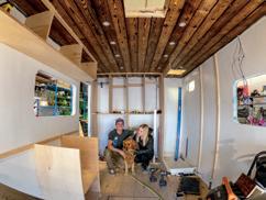

The day has come: mounting the shell to the frame of the truck. The interior framing, coming together at Josh’s shop in Farmington, Utah. Moments after the shell was mounted to the truck, I was psyched to see that the pass-through lined up perfectly. Opening page: On our first night in the Roamer in Utah’s Bonneville Salt Flats, we awoke to a storm off in the distance.
by George Raggets

more impressive skill set. I told him my idea, and he was immediately on board. While knowing full well my two-month timeline was hilariously unrealistic, Josh withheld voicing his doubts.
We started with sandwiched wall construction panels: 1/2-inch HDO plywood, 2-inch foam board, 1/2-inch HDO—glued, through-bolted together, and attached to a minimal steel frame. After two months of working every waking hour outside of my paid projects, we were nowhere near being finished. Every single step of the way was more complicated than expected. I would make a list of goals for the day that would take a week. So many times, I had my face in my hands, pondering what I had gotten myself into. After over 20 months, we are finally living in the vehicle. The entire process
was documented on YouTube under the playlist “The MuseRoamer Project.”
I wanted a high-end, clean finish and an outstandingly functional space. As a fulltime creator and athlete, I needed to carry snowboards, kiteboards, paragliders, climbing gear, camera gear, have a place to charge batteries and work efficiently from, and all the other necessities that come along with living reasonably comfortably in a vehicle. One of the things I’m most proud of is the amount of high-level thinking, planning, and logistics that went into the design. There is little to no dead space, and everything has its home. We utilized the subfloor frame for 66 gallons of fresh water and additional storage while keeping everything


2004 Ford F-550, custom-built shell and pass-through
POWER
6.0 turbo-diesel engine, bulletproofed
SUSPENSION AND DRIVE
Buckstop 3.5-inch suspension lift (from SRW conversion kit) Hellwig sway bar
WHEELS AND TIRES
Continental MPT 81 tires
Buckstop reversible steel wheels
RECOVERY AND ARMOR
Buckstop carbon steel bumper
Warn 16.5tI-S heavyweight winch
ACCESSORIES
AM Solar Zamp 170-watt solar panels
Lion Energy lithium-ion batteries
Dometic Fan-tastic vents
Dometic Penguin II AC unit
Dometic S7 510mm and S7 1,110mm windows
Dometic small 12111 furnace
Dometic cassette toilet
Dometic 6-gallon water heater
Dometic three-burner range/oven
Dometic 3.5-cubic-foot refrigerator
Dometic 13-foot awning
Redpoint Woodworks raw slab sycamore countertop and dinette table
Baja Designs S2 Sport lights, S8 30-inch light bar
Baja Designs XL-R Pro lights, LP6 Pro spot lights/driving lights
Vorsheer 60-gallon custom water tanks
Vorsheer custom powder-coated rear and underbelly storage boxes
Vorsheer custom powder-coated roof rack and ladder
Kicker Audio 12-inch CompRT
Sub, KXA 800.5 amp, speakers
Custom overhead cabinets, his and hers closets
Indoor/outdoor showers, custom glass shower door
WeBoost Drive X RV cell signal booster
Dell 32-inch 4k monitor
Sony soundbar
Yakima SkyBox 16 cargo roof box
Froli sleep system
Torklift International GlowStep

within the thermal envelope. The lighting is comprised of three different zones on dimmers, and when our overhead cabinets open, they don’t obstruct the lights. The top of the floor is directly in line with the bottom of the door opening so we can easily sweep out the cabin. These little details make all the difference. We used all Dometic stainless steel appliances, custom built his and hers closets, have beautiful sycamore slab countertops, a Shou Sugi Ban ceiling, and vinyl plank flooring for that clean finish I envisioned. After living in the space full time for over six months, we love the layout, look, and functionality of everything. We can comfortably host four to six (total) people for dinner, have pretty much all the gear and space we need, and I can conveniently work from my desk with a newly-installed 32-inch external monitor.
The design evolved as time went on and exceeded my expectations in the end. There was a crossroads somewhere along the way where we decided to build this thing to the absolute best of my ability. I implemented the cliché analogy of climbing a mountain. Often, it is hard, painful at times, and you just want to be done. But a few weeks later,
when you’re telling the story, you’ve mostly forgotten about how miserable you were in the moment and are rooted in the accomplishment. For the first time in my life, I truly gave something 100 percent of myself. A project that took almost 2 years probably took 10 years off my life, but I’m so proud of the end result.
I would not have been able to pull the build off without Josh and his shop, a few other good friends who lent a hand, an incredibly patient and supportive girlfriend, and a handful of brands who believed I could pull it off. And we are beyond excited to finally be hitting the road for Season Three of the Tiny Home Adventure in the MuseRoamer.
by
CAMPER REPARADISE reparadise.co OAKLEY OFF-ROAD oakleyoffroad.com


Make your next overland mission kinder to the planet.
By Morgan Sjogren

My Jeep grants me access to farflung destinations. Opening page: Contemplating my place, basking in the beauty of the magnificent sun.
Iturnoff the highway onto the red dirt road and feel every bump beneath me as the whirling tires kick up dust. When I arrive at my campsite, I step out into the night with a renewed stillness, gazing up at the stars overhead, listening to coyotes howl, the cottonwood leaves rustling in the warm breeze. I launch into long lonely backroads in my Jeep for the same reasons I like to use my feet on remote trails—to see the stunning mountain vistas, smell the scent of fresh pine, or stop to gaze upon a red-tailed hawk in flight. It’s a way to reconnect with nature.
I am a runner, and buying a Jeep in order to venture down new trails had the unexpected side effect of me falling in love with off-pavement driving. I began to seek the thrill of the dirt road less traveled as much as the run it was leading me to. I immediately began to see these activities as complementary hobbies. The combination eventually drove me toward another passion: defending wild places.
Ironically, I blame my Jeep for my deep dive into environmental activism. In 2017, I drove up the Moki Dugway, a goose-necking dirt road with precipitous ledges to the newly minted Bears Ears National Monument. I quickly learned that this landscape’s sweeping desert vistas, towering mountains, and cultural artifacts (the highest density found in the US) were all in danger of reduced protections to pave the way for extractive industries. Later that year, the monument was reduced by 85 percent. I was disheartened by the division of the OHV and environmental communities around this decision. After all, getting to this remote area in Southern Utah requires an off-road vehicle, and retaining full protections of its 1.35 million acres does not impede OHVs.
The United States is home to 640 million acres of public lands, or 10 percent of the country’s total landmass. If you partake in off-road driving, you’ve most likely benefited from these open spaces. While much of this land is set aside for multi-use purposes, there are some landscapes that are deserving of extra protection, be it for sensitive ecosystems or rich human history. All too often, an imaginary line is drawn in the sand that if you want to preserve these areas, you are negating your opportunities to roam the open roads. This is often where overlanders and environmentalists get unnecessarily pitted against each other. While environmental protection can lead to off-pavement driving restrictions in some cases, it largely prevents the development of new roads.


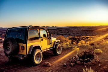


Clockwise from top right: Some landscapes are deserving of extra protection. Alpine tundra brings a splash of green to this idyllic lakeside setting. Vegetation can be found in the most unlikely places in the desert. Ironically, I blame my Jeep for my deep dive into environmental activism. Water is a powerful force of nature. We are but a small part of this planet we call home, yet we can play a big role in its preservation. Opposite: Taking the time to identify with the land upon which we tread can increase one’s appreciation thereof.
Meanwhile, the western US, in particular, is still home to some of the most extensive off-road driving networks in the world. There are 43,858 miles of dirt and gravel roads within the Bureau of Land Management’s jurisdiction. Protecting the surrounding areas means drivers get to appreciate rich biodiversity, thriving wildlife, preserved cultural artifacts, and healthier water and air. It sure sounds better than driving through an oil field to me.
I’m either considered a Jeeper or a tree hugger. As I navigate this terrain on four wheels and on foot, I increasingly find less distance between them. Yes, you can enjoy off-road driving and be an advocate for the environment.
In my life before owning a Jeep, I considered myself someone who cared about the environment. Sure, I picked up my trash and limited my water usage, but my awareness of how to be a steward of the places I cared about mostly stopped there. As I propelled myself deeper into this new landscape, driving on dirt roads and hiking remote trails, I began to witness more of the inextricable link between myself and the natural world. In turn, I felt a deeper call to learn how to help protect it and take action, inspired in part through my love for overlanding.
Yet, as both an overlander and an environmentalist, I still find myself riding a line between seemingly contradictory worlds where stereotypes and stigmas abound. I’m either considered a Jeeper or a tree hugger. As I navigate this terrain on four wheels and on foot, I increasingly find less distance between them. Yes, you can enjoy off-road driving and be an advocate for the environment. At the same time, it’s imperative to recognize that there is no such thing as a perfect environmentalist.
Though I try to limit unnecessary vehicle travel for the good of the planet, most human-powered adventurers are still reliant on four wheels to a degree. I recognize it’s rare for anyone to get anywhere without a vehicle, especially to remote trailheads and backcountry landscapes that can be hours off paved highways. But it’s becoming increasingly difficult for me to reconcile some aspects of this dichotomy. While my Jeep grants me access to far-flung destinations, allowing me to stretch my appreciation and knowledge of a place, it does burn fossil fuels extracted from landscapes no different to the same ones I strive to help protect from this industry. Vehicle emissions and car manufacturing also contribute to poor air quality and climate change, among other concerns. When I start going down this rabbit hole, I begin to either feel hopeless or that I should cease driving altogether.


I experimented with the latter idea for almost two months in the spring of 2020. With the Covid-19 pandemic in full force and shelter at home orders in place, I rarely turned the ignition on my Jeep. In fact, my battery eventually died. Instead, I devoted myself to exploring the trails down the street on foot, amazed at how many details and opportunities I’d missed flying in and out of town on past overland adventures. Though I missed driving during the restrictions, I appreciated that this temporary shift was better for the earth. It also reminded me to be grateful for the plethora of wide-open spaces in my backyard, a privilege that does not extend to everyone. However, as a nomad by nature I started to feel like I was losing myself, the part of me that flutters on a bumpy road when en route to somewhere I’ve never been before. As soon as restrictions were lifted, I hopped back in my Jeep to drive to my favorite campsite in the desert—with a renewed commitment that my drive time would continue to be balanced with more environmentally friendly home time.
As outdoor recreation grows in popularity along with an increase in domestic travel due to the pandemic, and the public pushes further into the farthest reaches of our backcountry areas, the need to educate all user groups about environmental ethics must also increase. I’ve seen the devastating effects on our wild places caused by two-footed recreators and four wheelers alike: toilet paper and human waste left unburied, vandalized rocks in areas you can only get to by foot, tire tracks across fragile meadows. They all cause irreparable harm to the environment, and yet, it doesn’t cross my mind that a specific user group is to blame. Rather, these are the results of carelessness, disrespect, and a lack of education, no matter who or what causes them. With this, the stereotypes about outdoor user groups need to go out the window. Whether you’re getting out to drive, walk, bike, camp, or bird watch, we all play an essential role in caring for our environment and recreating responsibility and respectfully.
This past summer, I saw unprecedented numbers of visitors in the San Juan Mountains of southwestern Colorado. The majestic mountains and extensive network of dirt roads make this area a mecca for motorheads and human-powered adventurers alike. Sadly, the uptick in tourism resulted in increased illegal offroad driving, users often disregarding signs and road closures, much of it resulting in damage to the area’s fragile alpine tundra. As I looked upon faint tire tracks across the green grass of a delicate marshland, disappointment engulfed me. Although it’s maddening to see critical ecosystems being damaged and destroyed, equally frustrating is the lack of information available
Here are some critical ways you can make your next overland mission (or drive to the trailhead) better on the planet.
PACK IT OUT Always be prepared to carry out all trash or human waste. Travel with trash bags in your rig or strap a Trasharoo on your spare tire. For human waste, you can purchase wag bags at most outdoor supply stores. Doubling up zip-lock baggies is a secure way to stash used TP.
The impact of one tire track or human footprint can leave long-lasting marks or irreparable damage to fragile ecosystems. To prevent this, always stay on designated roads and trails and follow signs and regulations. Likewise, always park your rig and/or set up camp at designated pullouts and developed campsites.
OBSERVE ALL POSTED SIGNS This includes indications of temporary closures and private property.
KEEP A CAREFUL WATCH for wildlife and human traffic, slowing down or even stopping in their presence.
LEAVE NO TRACE Familiarize yourself with the principles of the Leave No Trace Center for Outdoor Ethics, which “provides research, education, and initiatives so every person who ventures outside can protect and enjoy our world responsibly.”
CONSIDER SPENDING MORE TIME PARKED You’ve traveled a long way from civilization to get here. Why not stay awhile? Rather than making every day of your journey about driving, spending a day (or a few) parked in one spot to explore on foot can reduce the carbon footprint of your trip and help you learn more about the natural world around you.
OFFSET YOUR TRIPS I like to offset my big overland excursions with more time staying parked when I’m at home. This means going on a run or walk from the front door instead of across town or using up all the leftovers before hitting the store again. These small reductions in driving can add up to significant differences in our carbon footprint over time.
WILDERNESS TITHING Consider joining or making a donation to conservation groups active in the places you treasure. So often, this helps restoration efforts, cleanups, and advocacy that help protect the areas surrounding the roads less traveled.
STUDY UP Taking the time to read books, articles, and watch videos to learn more about the destinations you travel to while overlanding can help enhance your experience. Pay particular attention to environmental concerns, endangered species, and climate issues.

about outdoor ethics and Leave No Trace. Likewise, I felt that an improved understanding and knowledge base of the places people are recreating could help shape their investment in caring for them as it has mine.
If everyone knew how special and irreplaceable something like alpine tundra is, would they still drive on it?
Alpine tundra is a dense grassy area between the treeline and the alpine that is the remnants of heavy glaciation during the last ice age. In mid-summer, these green slopes are coated in a rainbow of wildflowers. Though alpine tundra grows in the southwestern United States, just hours from dry and barren desert, it resembles what you’d find in the Arctic Circle. Most important of all, it can take upward of 100 years to regenerate from damage.
Environmentalism and education about the natural world need to be intersectional and not political.
Of course, alpine tundra is not something you typically read about in an off-road magazine or website. And that’s a problem. Environmentalism and education about the natural world need to be intersectional and not political. By expanding access to information and stories that help us understand the landscapes we traverse, we can instill an ethos among overlanders to stay on trails, make a connection to the land, and do our part to help protect these places.
Near the same area where I saw the tire tracks, I came across a more encouraging site. A family had pulled over their rig on the bumpy road and were admiring the meadow. I asked them if they were bird watching, to which the dad responded, “No, we just stopped to admire the fen. Believe it or not, these are the headwaters of the Dolores River, and the marshes are actually slowly flowing away from us.” I stopped in my own tracks and looked across the expanse of tall green grasses. Sure, it was lush and beautiful, strewn with summer afternoon light, but what I could not see was its movement toward something much bigger than itself. The family eventually packed themselves back into their ATV and continued driving down the road toward the flow of the river, all of us a part of something bigger. I kept walking toward my Jeep, ready to hug both the trees and the road.
Joy can often be found in the simplest of pleasures.

These favorites are destined to find their way into your permanent kit.


By Matt Swartz


WhenI’m about to embark on a road trip, be it within Colorado or farther afield, my partner and I start by making a packing list. We do this because, without it, I will inevitably leave something important behind, prompting a discussion about decisions I made long ago when I was a younger, more impulsive human. But I digress. Making a list helps us systematically consider all of the gear (and trust me, there is a lot to consider) that could provide an elevated level of comfort for our particular destination. Having a list also helps us avoid leaving things behind when it is time to pack everything back into our car and head home.
No matter where we are headed or how long our road trip will be, there are a few things that make the cut without fail. You could call these items my go-to gear. Most of them are basic in function (except maybe my camera), and most of them are carried in my pocket, over my shoulder, or worn on my feet. Through trial-and-error, I’ve found that no matter what environment I’m headed to, what time of year it is, or what objective I am trying to accomplish, I always put these items to use.
LONE PEAK ALL-WEATHER MID-MESH HIKING SHOES
The Lone Peak is a hybrid between a hiking boot and a trail shoe, offering above-the-ankle support in an incredibly lightweight package. They feature a zero-drop sole and an extrawide toe box. With a thicker sock, I find them substantial enough for winter, but I often use them during the summer too. Available in sizes for both men and women.
$170 | ALTRARUNNING.COM
SSD T5 PORTABLE SOLID STATE DRIVE
Solid-state hard drives go hand-in-hand with a digital camera. They are a great alternative to traditional mechanical drives because they are much less prone to damage caused by accidental drops or rough roads. The Samsung is tiny, with fast read/write speeds, and it provides a secure place to store backups of memory cards—especially important on longer trips.
$120 AND UP | SAMSUNG.COM
INSULATED TKWIDE, 64 OUNCES
A water bottle is a standard part of everyone’s kit these days, and this half-gallon-sized, insulated bottle from Klean Kanteen comes along on every one of my road trips. It literally keeps drinks cold for days in warm weather (or vice-versa). The 64-ounce size is large enough to encourage proper hydration, and I usually only need to refill it once a day.
$60 | KLEANKANTEEN.COM
α7R III
When I travel, I always bring a camera, and right now, the α7R III from Sony is my weapon of choice. It’s a full-frame digital camera that captures 42-megapixel images with up to 15 stops of dynamic range. The α7 platform has been around long enough that there are a huge number of lenses available, both native and third-party (I recommend pairing this camera with Zeiss primes).
$2,300 | SONY.COM
GRIPTILIAN
I’m a big fan of Oregon-based knife-maker Benchmade. They have an incredible warranty and a free program called Lifesharp that will service and sharpen your knife as often as you want. When I travel, the Griptilian has a reserved place in my pocket. Because of its more modest price, I’m not afraid to abuse it a little bit.
$140 | BENCHMADE.COM
BLACK HOLE DUFFEL, 55L
When it comes to hauling around all of my belongings, these duffel bags from Patagonia are perfect. They are made from 100-percent recycled body fabric, lining, and webbing and come in 40-, 55-, 70-, and 100-liter capacities. They are highly water-resistant and have removable backpack straps.
$129 AND UP | PATAGONIA.COM

An illuminating journey across Myanmar’s Naga Self-administered Zone.
By Antonia Bolingbroke-Kent


The boat was pulling into Hkamti, an old Chinese trading post on the upper reaches of the Chindwin River, when the young man accosted me. A wild-eyed Naga with black teeth and a strange, high voice, his English was punctuated by eruptions of manic laughter. “Look at my hands,” he whined; they were covered in dirt and stained yellow. “I’ve been collecting poisonous beetles to sell to the Chinese—they use them for medicine.” At this, he let out another shriek of laughter. “We Burmese Nagas have no jobs, no money, no choice; we have to do things like this to survive.” He laughed again and stepped closer, his energy unnerving me. His brother was a Naga rebel, he said, and many of his friends fought for the cause. “The Indian Nagas have forgotten us. We’ve been left behind, but we have to keep on fighting.”
It was early December, and after two days of travelling up the Chindwin, I was nearing the jungle-soaked mountains of Myanmar’s Naga Self-administered Zone. Home to 120,000 Nagas—a Tibeto-Burman people made up of an estimated 70 tribes—this forbidding land forms the jagged spine of the Indo-Myanmar border, its densely packed peaks piercing the skies between the Brahmaputra and Chindwin rivers. Look at it on Google Earth, and all you see is a tangle of green; the nearest marked road is well over the border in the Northeast Indian state of Nagaland.
Nobody really knows who settled here first and where they came from. But by the time the British annexed the region in 1885, these hills were home to the Nagas, headhunters of singularly fearsome repute. Not that any Brits were brave enough to venture this far. While hardy surveyors penned sensational accounts about the “barbarous” Naga tribes of Northeast India, those living beyond the blue wall of the Patkai Range remained a mystery.
A century and a half later, these mountains, and the people who live here, remain tantalisingly undocumented. While much has been written of the Naga tribes in India, Myanmar’s Nagas are barely known. Their villages, and the mountains they perch on, have remained a rare blank space on the map—unGoogleable, uncharted, and far, far away from the pages of any guidebook.

In Hkamti, I met up with Juu, a guide from Yangon, and two local “bike boys,” their tiny 125cc Kenbo motorbikes bulging with supplies for the coming weeks. I’d spent a month motorcycling solo across Nagaland, but in Myanmar, a country still shadowed by military rule, my movements would be far more restricted. I wasn’t allowed to ride my own motorbike up here, nor could I travel without a licensed Burmese guide. If I wanted


to explore these little-known mountains, travelling with a guide and two local bikes was the only way forward. Squeezing between my rider—a garrulous young Naga called Man Htaung—a sack of cauliflowers, and a box of motorbike spares, I steeled myself for a bone-juddering few weeks.
The boys set off like gunshots, corkscrewing into the hills on a red dirt road, the silence of the jungle shattered by the roar of after-market exhausts. With my knees folded under me and a rider who seemed to be competing in his own Naga TT, I felt like a jockey on a tiny, bolting horse.
Aching and coated in dust, we reached Lahe, the first Naga settlement north of Hkamti, in the early afternoon, its bamboo and concrete buildings sprawled over a bluff amidst jungle-drenched peaks. At the town’s only guesthouse, a building near the monastery, the owners balked at having a foreigner, only relenting after Juu agreed to fill in the complicated immigration forms. Later, we met up with a policeman and immigration officer at a noodle-shack in town; Juu fielded their questions as Mariah Carey’s “Without You” blasted out of a tinny radio. “Don’t worry, I know how to deal with immigration,” winked Juu. As one of only a handful of Burmese guides who know the Naga Hills, I hoped she was right.
This, you see, is where it gets complicated. As a foreigner, the law said I wasn’t allowed to leave Lahe on the back of a motorbike. Nor could I travel beyond the two nearest villages. The most interesting places, high in the mountains on the Indian border, were closed to foreigners. But we were travelling by bike, and looking for a get-around.
The following morning we reported to immigration on foot, strapped our luggage onto the bikes, and sped out of town in a cloud of orange dust. When I dared look back, Lahe had vanished. All I could see was a crumpled quilt of mountains unfurling in all directions, the vivid colors of the nearest bluffs smudging to a blue, supernal mist.
For two days, we zig-zagged north towards the Indian border, bumping along narrow tracks whose surface had been gouged into peaks and ruts by the violence of the previous monsoon. At times, the dust gave way to lakes of mud, our knobbly tyres sliding in the mire. Twice we threaded through palm-thatched villages, but otherwise, there was nothing but plunging ravines, dark tunnels of jungle, and the buzz of our straining engines.
Our first night was spent in a Lainung Naga village, folded into the seam of a valley between high walls of mountains. Yellow rice paddies flanked a curling river; black pigs, bony dogs, and clucking chickens trailed wakes of noisy offspring. We’d long passed the two villages foreigners are officially allowed to stay in, but the chief, an imposing octogenarian with blue lines tattooed down his chin, gave us permission to sleep in the simple wooden monastery.
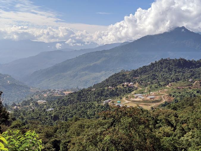
Precipitous slopes plunged to shadowy valleys where clouds of white butterflies fluttered over forest streams.
We ate supper in the smoke-filled hut of a local hunter called Anu. He squatted by the fire, cleaning his rifle and butchering the last of a sambar stag he’d shot the previous night. Its skull gleamed white on the wall behind me, beside those of deer, monkeys, bears, boars, and clouded leopards. Speaking in faltering Burmese, he told us he’d recently shot a bear, selling the bile (used in traditional Asian medicines) to a trader in Lahe for the equivalent of £150 ($200). I’d heard similar stories in India, where I’d met Nagas who hunted bears and pangolins specifically for the Chinese market. It was becoming a sadly recurrent theme of my journey.
The tracks became fainter as we headed north, the mountains steeper, dense walls of jungle pressing in on all sides. Precipitous slopes plunged to shadowy valleys where clouds of white butterflies fluttered over forest streams. Lahe was the last place there’d been electricity, a mobile signal, cars, or shops. Out here, there was nothing—just the odd shaggy village barnacled along
the spine of a ridge. Around them, the slopes burgeoned with young opium, a crop first introduced to the Nagas by the British.
The farther we went, the harder the riding became. I jogged after Man Htaung as he forced the bike up vertiginous slopes and tensed as we bumped down steep rocky paths, the bike bucking and sliding as we went. Several times a day, we stopped to pour water over the overheating engines, clouds of white steam hissing into the trees. By now, I understood what the Naga people meant when they said only “true friends or serious enemies” could reach these remote villages. If anything happened, we were well and truly on our own.
Late one afternoon, we reached a Konyak Naga village three miles from the Indian border. I spotted it from a few miles away, that familiar sight of huts half sunk in a storm of palms and hillsides stripped by jhum (slash and burn) cultivation, like sheep half-shorn of their fleece. A church steeple poked above the trees, gilded by the last of the light.
As we rode into the village, we paused beside a stone inscribed in English. It commemorated the 2,587 villag-

ers who’d died of “unbearable plague and epidemic” in the mid-1980s, at the same time fighting between the Burmese Army and Naga rebels had killed countless more.
Man Htaung had grown up here, so we stayed with his cousin, the pastor—a quiet, melancholy man who’d lost 9 of his 10 children to diarrhoea and “fever.” The hut was dark and thick with cobwebs, and I slept on a wooden platform beneath rows of smoke-blackened animal skulls. When I blew up my Therm-a-Rest and wriggled into my sleeping bag, the pastor looked on in amazement; never had such luxury been seen in these parts.
In the morning, I watched the sun hoist itself over the opposite ridge, bathing the hills in a glistening, golden light. Barefoot women winnowed maize in the winter sun, and children giggled shyly when they saw me, running away in hysterics when I said, “Mong Mae Thong,” hello in the local dialect. It was a fantastically gorgeous place, the sort of wild, unknowable country that makes me want to ditch everything and march off into the mists. Looking upon such beauty, it was hard to believe the village had been ravaged by such a terrible epidemic in recent memory.
The village angh, or king, lived in a large hut decorated with buffalo skulls, carved tigers, and an Indian church calendar. An impish man with a Confucian face and a wispy beard, he was formally dressed in a red embroidered waistcoat, a bear fur hat, and a pair of navy Calvin Klein shorts. Around his neck hung the row of small bronze heads traditionally worn by Konyak headhunters. He greeted me from his wooden throne beside the fire, waving his hands to shush the huddle of grimy, opium-addled men who squatted around the hearth.
I asked him about life on the border. “We knew nothing about the border until 1971 when the army came and put markers in the ground,” he said. “But we are all Naga. The border means nothing!” He told me the villagers used Indian rupees, bought rice from a Konyak village across the border, and sent their children to study in India. “Look at him,” he said, pointing to a particularly begrimed addict beside the fire. “He’s from India, but he’s our clan member, so we look after him.”
Even their religion was imported, brought by Indian missionaries in the mid-1980s. “That was when we stopped head-hunting and buried the village skull collection,” said the angh. “Now we no longer live in fear, and we love each other instead.”
Head-hunting, and no, I don’t mean an executive search, used to be rife among the Naga tribes. Until a few decades ago, there was nothing a warrior adored more than returning from a raid on a nearby village with a bloody basket of human heads. Heads, they believed, were the dwelling place of the soul and hence receptacles of great power. The more of these grisly prizes a village had dangling from their head tree, the greater fertility and good fortune they’d enjoy.
The British, nominal rulers of these wild hills from the mid-19th century until the 1940s, did their darndest to outlaw the practice, but without much luck. Headhunting was simply too embedded in the Naga way of life. As Verrier Elwin, the British anthropologist, wrote, “If you talk to a Naga on such tedious topics as theology or economics...he quickly slips away to have a refreshing rice beer. Open the question of head-hunting and his eyes light up and a torrent of exciting and improper information pours from his lips.”
Now the Konyak, along with 99 percent of the Nagas, are all Baptist, and men who sang lusty war songs sing “Praise the Lord” instead. Although here, in these opium-riddled hills, the grip of the church is far looser than in India’s Nagaland, where even alcohol is banned.
The big question was whether we could go any farther. The next villages bordered the conflict-driven Kachin State and were strictly offlimits to outsiders. “To get there, we have to pass a Burmese Army post,” said Juu, as we ate rice around the pastor’s fire that evening. “If they catch us, we’ll be in serious trouble.” Whether that meant a slap on the hand, prison, or deportation wasn’t clear.
It was a fantastically gorgeous place, the sort of wild, unknowable country that makes me want to ditch everything and march off into the mists.
Man Htaung suggested we go and discuss the matter with his uncle, the local commander of the NCSN-K, one of the main Naga rebel groups. Ten minutes later, we were sitting around the fire in his hut.
Tales of the insurgency had stalked my journey across the Naga Hills. While head-hunting and the British may be gone, the Naga people are still at war—a decadeslong struggle for independence that’s cost an estimated 200,000 Naga lives. Although an official ceasefire was signed between the Indian government and Naga political groups in 1997, the situation remains unresolved. The NSCN-K had attacked an Indian Army border post a few weeks previously, and I knew many of the rebel camps were hidden in this remote corner of Myanmar.
There were so many things I wanted to ask this thin, intelligent-looking man in khaki fatigues, but instead, I sat quietly while he and Man Htaung caught up on family matters. Around us, five other men talked and smoked opium, the gurgle of their pipes mixing with the twilight clatter of insects.
After a while, their conversation became animated, the uncle eying me with interest. “What’s he saying? Does he think it’s okay to go on?” I asked. Man Htaung laughed. “No! I tell him about that blow-up thing you sleep on. He’s very interested. He says it would be good for his soldiers.”
My Therm-a-Rest aside, the commander moved on to more serious matters. “There are 200 Burmese soldiers patrolling the border at the moment, checking the

boundary markers and looking for insurgents,” he said, fiddling with his walkie-talkie. Above him, a rack of rifles glinted in the firelight, and an old head-hunting basket gathered dust. “It’s okay to go on,” he told Man Htaung, but only if we avoided the army and made sure no one in the villages reported us.
To my disappointment, he didn’t want to discuss the NSCN-K, but Man Htaung later told me they were funded by the Chinese and that his uncle was busy recruiting new cadres. With no other jobs and little connection to the rest of Myanmar, the men had little choice—it was either farming, fighting, or working in godawful jade mines near Hkamti. “We want unity for the Naga,” said Man Htaung, “we don’t want any borders.”
Above him, a rack of rifles glinted in the firelight, and an old head-hunting basket gathered dust.
It was a heart-thudding ride northeast from here along the ridge of the Indian Divide. We struggled up steep slopes and slid down to splashing rivers, the boys inching the wheels across slippery notched logs. Above us, mighty trees trailed bearded creepers, and bulbuls darted through the green. The only other people we saw were two men walking barefoot to their fields, guns slung over bony shoulders, gaping as they spotted my white skin. After a few hours, we stopped and looked back towards Man Htaung’s village, its huts specks of flotsam on an ocean of emerald wilderness.
At the army post, a big yellow concrete building on a bluff, we raced through the jungle on a hidden track, heads down, hearts thundering, whipped by elephant grass and bamboo. An hour later, we stopped, sweating and jubilant—we’d made it into the forbidden land.
Beyond, the path threaded along the shoulders of steep, dry mountains. Gone was the lush jungle. In its place was a rocky, inhospitable landscape and eddies of sallow dust. Meanwhile, the worse the “road” became, the faster Man Htaung rode, laughing like a drain every time he felt me tense. He even laughed when we had to carry the bikes across a recent landslide, our boots sending clods of earth spinning into a dark ravine.
That night we stayed in a village that reeked of poverty and hardship. The dogs were starving. The children were covered in filth and bloated with malnutrition. The chief, a kindly man with a thatch of grey hair, said the ground was too rocky to grow rice, and they often experienced food shortages. “We hunt and sell our opium to survive,” he shrugged, sucking on a bamboo flagon of maize wine. As we spoke, 50 hungry faces jostled at the open walls of his hut, watching our every move.
“The Naga were lucky. Other ethnic groups, like the Karen, were massacred by the junta,” Juu told me later. “But the Naga had no gold or rubies, so were left to live like animals. They had no help, but they were lucky.”
Walking around the village the next morning, trailed by a wake of ragged children, I’ve never felt so aware of


Clockwise from top right: The chief of the last, very poor village I went to. Man Htaung, on the overloaded Kenbo. These Naga children in a border village meet my gaze inquiringly. Some of them wear thanaka on their faces, a traditional Burmese skin treatment made from tree bark. A Naga man walks along the road, armed with his rifle for hunting. Opposite: Naga women, diligently pounding maize by hand.


my First World privilege. Three young boys were trying to dig a rat, their breakfast, out from under a hut. Others, some no more than three years old, queued at a borehole, waiting to fill up old jerry cans with water. From every hut came the rhythmic pounding of maize, the women exhaling with effort every time they brought the heavy mortar down.
In the middle of the village, a handsome older man sat on a bamboo platform, dandling a child on his knees. He wore a deerskin hat girdled with boar’s tusks, and round his neck hung the jawbone of a clouded leopard. When I gestured to the necklace, the man grinned and raised one arm in a spearing motion, grunting as he bought the imaginary weapon down.
Never have I been anywhere that’s made me so aware of my privileges: my ability to choose, my education, my access to all the everyday things we take for granted.
Before we left, a tiny, bent old woman came and asked us for medicine for a sprained wrist, and when Juu finished bandaging it, the woman presented her with an egg, the ultimate sign of respect. Nowhere had I felt the gulf between Myanmar’s Naga and mainstream Burmese society more keenly. For these villagers, Yangon was as distant as Alpha Centauri.
Several days later, on our way back to Lahe, I decided to walk the last 10 kilometres. It was a hot, dry day, and the sun was beating down from an azure sky. About halfway, just as I was wondering why I hadn’t stayed on the bike, a group of Nagas walked past with heavy baskets strapped around their foreheads. They’d been shopping in Lahe, they gestured, and now had a two-day journey back to their village. We waved our goodbyes, and I watched them disappear around the corner, flip-flops slapping as they went. The moment distilled something I’d often thought about on this journey: how choice is a privilege, and a privilege that few Nagas have. I’d chosen to walk. They had no choice. But as with so many Nagas I’d met, they accepted their lot with remarkable good cheer and stoicism.
Clockwise from top right:
I’m writing this in the eye of the global coronavirus crisis, and over the past few months, I’ve thought of Myanmar’s Naga often. Never have I been anywhere that’s made me so aware of my privileges: my ability to choose, my education, my access to all the everyday things we take for granted. While many of us may be temporarily deprived of our freedoms, we still have running water, electricity, shops, and healthcare—luxuries that the villagers I met can only dream of. And for this, we should be extremely grateful.
Juu’s name has been changed to protect her identity. The names of the villages have been purposely obscured.


A culinary expedition down memory lane revisits the economics of basic traveling in Mexico.
By Gary Wescott


In1977, I had the pleasure of camping on the beaches of Baja’s beautiful Sea of Cortez and mainland Mexico’s Pacific Coast. That was back in the days when I was living in a Land Rover (La Tortuga Azul, aka The Turtle One) on the slow road to South America. We camped, bathed in the warm ocean, snorkeled, played frisbee on the beach, and relished a life many people would consider a permanent vacation. We caught or speared fish, and occasionally went to town to pick up necessary supplies like fresh fruit and vegetables and maybe a couple of cold beers, all for something around $25 a week. We had no insurance of any kind, and our out-of-pocket expenses other than food were basically gasoline, sold by cents per gallon, filling a propane tank every once in a while, and ice for our ice chest.
Having traveled through Baja many times since then, I’ve often wondered how much it would cost today for the same life. The only way to find out was to recreate the experience.
Crossing any border into Mexico can be confusing, and Tijuana, being one of the busiest, is no exception. If you’re traveling in a large camper, customs agents will sometimes direct you to drive your vehicle onto a giant X-ray platform, and you get out while it’s inspected. Monika and I instead crossed the friendly border at Tecate farther east. We still needed to get an FMM tourist permit (tourist card) and vehicle insurance. Both are mandatory these days.
Insurance is easy. There are several online options as well as offices near the border, but we have found the cheapest and best way is through the Discover Baja Travel Club (discoverbaja.com) in San Diego, online or in person. We bought the minimum for liability which is less expensive by the year if you plan on coming back or if you are spending more than 20 days. The Club can pre-fill your application for the FMM tourist permit for a small fee, $7 for members. We still needed to have it validated at the border and pay Mexico’s entry fee of $23 (free if you are staying less than seven days). We parked on the US side of the Tecate border crossing, walked across, got our card validated, and then walked back to get our vehicle. You’ll need a valid passport or passport card valid for six months.
The new “free” highway from Tecate wound its way through what is rapidly becoming a popular wine route, the Ruta de Vino. We didn’t stop at any of the 20 or so wineries and olive ranches scattered through the hills. Some offered camping, though.
Arriving in Ensenada, our first destination was the famous Mercado de Pescado to buy a couple of pounds of fresh shrimp and some filets for the next campfire. Other supplies were purchased at one of the many supermarkets in town where we found everything we needed for a couple of weeks, often at considerably lower prices than in California, and with a bigger selection of fruits and vegetables. It was hard to imagine we were actually in Mexico, with Costco, Sam’s Club, Walmart, Pep Boys, Staples, and other familiar businesses just down the highway.
After a couple of delicious fish tacos at the fish market, we went up the street for a mandatory stop at Hussong’s Cantina, established in 1890 by German immigrants. If you’re headed into Baja without visiting Hussong’s, your trip may be doomed—we tell you this from years of experience. This old watering hole was busy for a Thursday night, and we finally scored a table in a room crowded with more local Mexicans than tourists. We ordered two shots of their house tequila and a bag of peanuts. Toasting to a great adventure, we listened to a couple of roving Mariachi bands, ate our peanuts, and threw the shells on the floor in keeping with the local tradition.
Filling up our two fuel tanks in the morning at the Pemex gas station, we choked at the price of diesel: $4 a gallon.


Not so many years ago, it was 0.24 cents a gallon. That said, Mexican gas stations today are much cleaner now with acceptable restrooms and often have a convenience store attached. Visa is widely accepted at gas stations and supermarkets, making things easier in general.
We had been looking forward to some fresh oysters and clams, and we knew where to find them. A few hours south of Ensenada, we came to the dusty community of San Quintín, and just before entering Lázaro Cárdenas, we turned off Highway 1 onto a gravel road next to the military base. Stopping to air down our tires to a comfortable 30 psi for the washboard and sand ahead, we continued through old lava outcroppings to the second of the double-arm of the Bahía de San Quintín Bay, home to several oyster farms. We stopped at a small one called Ostiones Bahía on the north end and asked if we could camp for the night. It was a secluded spot by the bay, and we could buy a fresh batch of oysters in the morning to take with us.
As our gourmet trip down memory lane progressed, big fat clams were on the menu. Continuing west to the small fishing village on the outer edge of the Pacific Coast, we were stopped dead. The old sand track through the dunes that demanded four-wheel drive had been erased by the last hurricane. The only way to get to the other end of the beach where the road continued was the beach, which at the
moment was covered with 4 inches of water and completely impassable. We waited a couple of hours for the tide to recede. The soft sand at the entry to the beach was a little iffy, but as soon as we hit the hardpack, we zoomed down to the end and turned left up into more passable sand dunes. The two-track is regularly used by lobster and clam fishermen, folks who often don’t have four-wheel drive.
The tide was low, so we gathered a pot full of fresh mussels, picked right off the rocks in front of camp.
After winding up and down along the rocky coastline for a mile or two, the road ended abruptly, and we stopped at the last house, Antonio Jimenez’s home and compound. He doesn’t really charge for camping but appreciates a few dollars. There were shaded palapas, a table or two, and even an outhouse. We asked Antonio if we could get some clams, and shortly after, his son arrived with a bucket full. He charged us $5.50 for a dozen, and we set about preparing them for dinner. The tide was low, so we gathered a pot full of fresh mussels, picked right off the rocks in front of camp.
In the morning, where the road had ended, we made a 90-degree turn onto the 8-kilometer (5-mile) flat beach that ran down the Punta Mazo Peninsula. We had previously been stopped at a guarded gate where our license plate was recorded. Ecologists are worried that tourists and locals with
side-by-sides, buggies, and other off-road vehicles will ruin the beautiful sand dunes, home to at least one endangered bird species. Again, the seashore is passable only at low tide, which makes it a great clamming area. At the far end of the Punta Mazo strand, a steep and very soft track led to the point where there were lobster and clam camps and men harvesting special seaweed.
While the temptation was to relax here for a week and soak up the scenery, we remembered one of our goals on this adventure was to do some fishing and maybe recreate one of those weeks back in 1977. Fishing off the shore or rocks and spearfishing had always been productive, but in other years we usually had a boat. For this trip, we borrowed a Sea Eagle FastTrack Angler Pro inflatable kayak (Field Tested, p. 24) to ensure an endless supply of fresh fish. Timing our departure with the tide, we returned to Highway 1, picking up a few more oysters on the way.
Back in 1977, the highway had recently been paved to Baja’s tip at San José del Cabo. Traffic was rare back then, and trucks, few that there were, consisted of Chevy and International stake beds, sporting dingle balls behind a tinted windshield. The road was narrow, but their speed was maybe 35-40 mph, black smoke belching from their unmuffled four- or six-cylinder gas or nonturbo diesel engines. Fast-forward 40 years and today’s Highway 1 is not any wider, but there is a steady stream of Peterbilt, Mack, and Kenworth semi-trucks pulling 48- to 53-foot trailers with GVWs of 80,000 pounds—about 72 feet long and 8.5 feet wide, not counting their big mirrors.
We had about 9 inches from our tires to the centerline, plus our mirror, and about the same distance to the 6-inch drop-off on the right that often continued over a 5-foot berm on which many of the highways are built. To make it more gripping, there were sometimes no shoulders or even a white line to mark the edge of the pavement. The blacktop was not exactly pool-table flat either. With their 14.6-liter, 6-cylinder turbodiesel engines pumping out up to 600 horsepower, the semis’ speed often exceeded 60 mph, and they were in a hurry. By necessity, on a 15 mph blind hairpin corner, they usually needed to use part of our lane. Even on the long flats across the desert, with the load they were pulling and little side gusts, they were still “threading the needle,” so to speak.
The exciting ups and downs through vados, deep, dry flash flood crossings, were something like riding a giant roller coaster, when the cart starts up the track from the loading platform—click-clank, clickclank—and the brave ones hold their arms over their heads. You can’t see what’s coming up over the top. A left turn? Right turn? Steep downhill? A big semi-truck using all of his lane and part of yours? Everybody scream! It’s called “white-knuckle” driving. You can scream, too, but remember to keep your hands on the wheel.
In short, driving a full-size vehicle on these narrow highways requires 100 percent of your concentration. The frequent junkyards on the roadside are witness to those whose attention wandered. We stopped to take a few photos of what I estimated to be a $230,000 MAN Unicat expedition motorhome that dropped a wheel over the edge. It happens to the big trucks too, and the highway had plenty of pretty little cross markers to honor lives lost.
It was a relief when we turned off the pavement into the rock garden north of Cataviña to camp for the night. After a spectacular sunset, we grilled some red snapper filets over a mesquite fire and soaked up the amazing quiet of the desert night. The two-track from camp would take us west for about 50 miles to the Pacific Coast, passing through some of the most beautiful deserts on the Baja Peninsula. Fresh lobster was next on our shopping list.
Our favorite campsite overlooking a deserted beach was just around the point from one of the many fishing camps. No sooner had we set up our chairs and poured a glass of wine than a rattling Ford pickup arrived. We bought four lobsters from a friendly fisherman at $5.50 apiece (paid in pesos). Frozen lobster at our local supermarket back home were over $11.49 each.
Preparing fresh lobster is easy. Rip off the tail from the head and body. Insert one of the antennas into the tail, broken end first. As you pull it out, the sharp spines will remove everything you don’t want to eat. We cut a slot in the back of the shells, inserted a little butter, and wrapped them in foil, placing them on a hot grill for 10 minutes while we melted some butter and watched the sun fade into the Pacific.
Once again, the tranquility of this remote camp held us for a couple of days of beachcombing. Other than the guy who


had delivered our lobster, we had seen only a couple of vehicles on the road since we left the highway, without a semi-truck in sight.
While our yearn for peaceful desert nights, oysters, clams, mussels, and lobster had been filled, what about fish? As in fresh fish, the kind you catch and eat the same day. Heading south again, we made a quick stop in Mulegé (about 620 miles south of San Diego) and the historic Hotel Serenidad and campground where Monika and I met in 1977. Today, the campground has hot showers, a good internet connection, and even a laundromat. Unfortunately, we missed the weekly pig roast.
Still following our path down memory lane, we skirted the scenic coast of the Sea of Cortez to a beach we used to stay at for weeks at a time. It used to be free, but now they charge $8 a day for a palapa whether you need one or not. It’s become popular with both Mexicans and foreigners, drawing an interesting variety of daily vendors selling everything from carpets to fresh vegetables and fish. The good news is that there are now two or three rather stinky outhouses and a couple of trash cans to help keep the beach a little cleaner. The big trailers and motorhomes of the “snowbirds” can no longer dump their greywater into the bay.
Our first job was to get dinner. We inflated our kayak, which took only about 10 minutes. With a few pieces of scrap meat, the triggerfish were quick to take the bait. In an hour, we had more than we could eat and some for the next two days. The follow-
ing morning, we paddled a short way up and down the coast from camp just for fun.
With a freezer full of fish and lobster, it was time to head home, with a few stops along the way. One of our favorite old missions in Baja is the Misión San Francisco Javier, sometimes called the Jewel of the Missions because of its beauty. Located in the rugged mountains west of Loreto, the last time we visited the historic village, we fondly remembered the spectacular dirt road that serpentined up under steep cliffs, bumped around hairpin corners, and splashed through knee-deep arroyos. To our surprise, the 20-mile route into the mountains is now paved to San Javier, but still every bit as amazing.
Heading south again, we made a quick stop in Mulegé and the historic Hotel Serenidad and campground where Monika and I met in 1977.
Nothing in the village seems to have changed except they have power now, so the old town diesel generator that ran till 10:00 p.m. has been retired. We camped right in front of the church, and in the morning, we took the short walk behind to see something we had missed the first time. Shaded by rocky cliffs next to a spring-fed water channel, the last survivor of the first olive grove in Baja California still bears fruit. At an estimated 400 years old, the monarch is astonishing.
Inside the mission itself, a still-functioning church, we marveled at the goldleafed altar surrounded by eight life-size


Clockwise from top right: Winding through the sandy dunes west of Bahía de San Quintín was an overlander’s dream. We camped on Bahía Conceptíon for days at a time. The five-mile beach running along the Punta Mazo Peninsula west of Bahía de San Quintín was fun to drive at low tide. If you are going to enjoy lobster for dinner, you first have to train them. Opposite, left, top to bottom: We always operate under the catch and eat philosophy. Monika lands a nice cabrilla for dinner. Our Sea Eagle FastTrack Angler kayak allowed us to get to where the fish were. In 1977, fishing for your dinner was not even considered a sport. In late 2019, the triggerfish were as hungry as ever. Right: Our camp on Baja’s beautiful Sea of Cortez was ideal.


oil paintings. These had been shipped from mainland Mexico and then carried by mules to this remote location. With a backdrop of rugged cliffs, the soft morning light wrapped around the carved belfry and spires and filtered through Baja’s first stained glass windows.
The temptation now was to continue west all the way over to Highway 53 near the Pacific. But looking on the maps, that could have meant a couple more weeks of back road exploring. Returning to Highway 1, we headed north again. We wanted to stop one more time to visit our old friend Coco at Coco’s Corner. He was as jolly as ever. The rafters in his living room were still draped with women’s undies, and the walls were covered with mementos left by the thousands of people who have visited him over the years. We were pleased to see one of our old Turtle Expedition South America posters had a special place.
The track out of Coco’s was not paved, and the original sand two-track was preferable to the rough graded gravel. At length, we hit the pavement on the new blacktop coming from Puertecitos and San Felipe, a longtalked-about extension of Highway 5 from the Mexicali US border. Flash floods from the last hurricane had washed out some of the bridges and many of the vados and culverts. Their road engineers had clearly underestimated Mother Nature.
After negotiating at least 18 detours around washouts, we stopped for diesel in San Felipe and refilled our propane tank. Just
past the military checkpoint heading north, we turned west on the much-improved Highway 3 toward Ensenada and over to the easier border crossing at Tecate. There was still a long line, but it was much faster than Tijuana. Handing our passports to the immigration officer, we were back in California in less than a minute. The most dangerous part of the entire month-long adventure was yet to come: driving through Los Angeles traffic.
And what about the dream of camping on the beach for $25 a week? On this 38-day/1,964-mile adventure, fuel alone was $895. Food was about $589, including seafood we did not catch ourselves (clams, lobsters, oysters, shrimp). That’s already $273 a week. Then there was mandatory insurance, our FMM tourist card, camping and internet fees, restaurants—see where we’re going?
There are many places along the Sea of Cortez and the Pacific where you can wild camp, and even without a boat, the fish caught off the shore are free. Simple spearfishing in 15 to 20 feet of water can be very productive, and that’s free food too. If you camped on a nice beach for two or three weeks, your fuel costs would drop into the single digits. If you bought only food staples and necessities, could you do it for $25 a week? It’s not likely. But maybe for $50 or $75 a week. Would it be more fun if you spent $150 a week? Probably. Don’t forget to stop at Hussong’s Cantina in Ensenada.


That is the lengthy canoe miscalculation.

In May 1992, my wife and I drove a 1981 Toyota pickup truck from our home in the Colorado High Country to Central America, which, at the time, was a socio-political hot mess. But it had been a tough winter at 9,000 feet, and we needed a warm-weather vacation. I wrangled a deal with Canoe & Kayak magazine to pen a story basically asserting that Central America— through which we had traveled extensively eight years prior—was a perfect destination for paddlers who might consider the specter of random gunfire, possible kidnapping, and almost assured armed robbery to be a compelling component of the overall adventure package.
To procure the assignment, I might have overstated the amount of experience my wife and I had paddling together, which, in actuality, was zilch. There was also the slightest chance I may have stretched the truth regarding whether we owned a canoe, which, in fact, we did not.
Consequently, a couple of weeks before departing, I needed to purchase a boat in a locale that was still buried under 7 feet of snow. Fortunately, my buddy Bernie, who grew up in Minnesota’s Boundary Waters country, managed the Frisco Bay Marina, located on the shores of Dillon Reservoir. Bernie agreed to sell me the canoe he grew up paddling—a 17-foot, fullkeeled aluminum Alumacraft that was about 40 years old, weighed probably 90 pounds, and was made to carry heavy loads across great distances over large lakes in the North Woods.

Bernie told me that, a week prior, he had sold a 14.5-foot fiberglass canoe to another person driving to Central America. What are the chances?
We concocted a slap-dash roof-rack system, loaded the Alumacraft, and drove south, blissful in our ignorance.
SHORTLY AFTER ARRIVING IN GUATEMALA, THE CANOE HAD COME LOOSE FROM THE ROOF RACK BECAUSE THE ROAD HAD SEEMINGLY BEEN RECENTLY CARPETBOMBED BY B-52S.
We screwed up on at least two levels. First, a shiny aluminum canoe that was several feet longer than our truck attracted an inordinate amount of attention. It was like a thief beacon. Starting in the bone-dry Texas Panhandle, all the way down to Honduras, people descended upon us. They ran their fingers across the upturned hull, asking suspicious questions like, “If by some fortunate set of circumstances someone happened to come into possession of a canoe just like this one, how much do you think they could sell it for?”
Our elaborate security system consisted of several miles of heavily knotted rope and practicing various intimidating facial expressions.
When we crossed into Belize, we were required to take the canoe off and leave it at the border post because it was “illegal” to “import” a “boat” without a “proper permit.” This regulation was seemingly invented on the spot by customs officials who were casting acquisitive glances at our Alumacraft. To acquire the permit, we drove two hours to Belize City where we had to navigate the federal bureaucracy, consisting of one person—the country’s secretary of commerce— who, when we arrived, was getting drunk at a local cantina and 1) required that we enjoy several bottles of Belikin beer with him, 2) had never heard of the boatimport regulation, and 3) was only too happy to scrawl the mythical permit upon a cocktail napkin for what he considered to be a very reasonable fee of us paying off his $30 bar tab.
We then drove two hours back to the border. We arrived well after dark to retrieve our canoe, which was in the process of being heisted under the inattentive gaze of the border guards. We had to tug-of-war our Alumacraft away from the people who were trying to steal it. We loaded it up without ever having to show our “import permit.”
Shortly after arriving in Guatemala, the canoe had come loose from the roof rack because the road had seemingly been recently carpet-bombed by B-52s. In what appeared to be the middle of uninhabited nowhere, as I was tightening the tie-downs, three ex-
tremely intoxicated, knife-bearing men sporting deep facial scars stepped out of the dense foliage and tried to make off with our canoe. I mean, what were they going to do? Stumble through the jungle carrying a 17-foot Alumacraft? It didn’t seem like the most wellconceived plan. It was only after I pulled out my machete and let them know they would have to fight for it that they backed away, giving us time to drive off at an inadvisable rate of speed with the canoe, which I had not had the opportunity to tie back down, bouncing on the roof. Our intimidating facial expression security system had worked.
When we pulled into Tikal National Park, we were stunned to see a truck bearing Colorado plates and a 14.5-foot fiberglass canoe. The owner, who lived a stone’s throw from our house in Colorado, was an avid birder who had spent years paddling along the rivers of Central America. He took one look at our Alumacraft and scratched his head in abject bewilderment. “Why didn’t you bring a more appropriate canoe?” he asked while casting sympathetic glances toward my wife, who, by then, was asking herself the exact same question.
Which leads to the second, and perhaps most important, miscalculation: our canoe was way too long and cumbersome. The rivers we paddled upon—the Mopal, the Sittee, the Ulúa, et al.— were serpentine, about as wide as my desk and laden with low-hanging branches upon which dwelled all manner of tropical fauna. (The saucer-sized spiders were especially captivating.) There were close calls galore. For instance, at one point, I had to leap out of the canoe, which had the maneuverability of a Huck-Finn-type raft, into chest-deep, murky water to grab the stern to prevent us from barreling headlong into a river-wide sweeper. Here I feel compelled to point out that, while this was transpiring, my wife, mesmerized by the surrounding beauty, continued to paddle, oblivious to our circumstances. That was exciting. Once I finished coughing up several gallons of muddy water on the shore, we had a long talk about communication protocols.
We made it back to Colorado six weeks later. I returned the canoe to Bernie, who had regretted selling it to me since it held a childhood’s worth of sentimental value.
Now, I own a 15-foot inflatable Advanced Elements Convertible kayak, which is very versatile and fits unobtrusively in the back of my current overland vehicle—a 1999 4Runner. It is easy to hide. No cocktail-napkin import permits required.

BY ASHLEY GIORDANO

Losing her heart and soul to Africa, time and time again.

Bell-bottoms and platform shoes are en vogue. Bee
Gees’ disco hits top the music charts while Grease is the must-see film of the summer. Stephen King publishes The Stand, Cold War tensions will continue for another 13 years, and the Berlin Wall will remain in one piece for another decade. There are no cell phones, no electronic navigation devices, no Google. Travelers use hand-drawn or Russian satellite maps and compasses for navigation and communicate by letter. Highly anticipated, hand-scrawled updates from the road take weeks to arrive in loved ones’ mailboxes back home. It’s 1978—the world in which a young Lilli Mixich began her travels.
During a camping trip in Spain, touring in a shiny orange Opel Ascona and a ground tent, Lilli and her partner temporarily ditched their saloon car in Tarifa to join a bus tour heading for Tangier, Morocco. Not sure what to expect, the couple arrived in Northern Africa and found a whole new world outside of Europe. Lilli recalls what it felt like to arrive on another continent for the first time. “What I remember most of this trip were the unusual but wonderful aromatic scents, the shouts of the muezzin which woke us up every morning, and the congested roads and twisted alleyways of the souks in the old city. We were fascinated and wanted to come back to explore more of this unknown land.”
And so started Lilli’s lifelong love affair with Africa. Forty
years later, Lilli is now in her sixties and a self-proclaimed “social media junkie” traveling solo through Eastern and Southern Africa in her tiger-striped 1988 Toyota Land Cruiser HJ60 named Toyo. Whether for short-term trips, long-term overland travels, to live, or to work, the urge to explore has brought this German overlander back to African soil countless times over the past four decades. She has lost her heart to Africa, and after delving into a lifetime’s worth of memories, it is easy to understand why.
Your first overland trip was from Germany to Morocco back in 1979 in a Land Rover 109. Why did you and your partner at the time choose this vehicle for the journey?
We wanted to return to Morocco. But in a shiny Opel Ascona? No way. We wanted an off-road 4WD vehicle. Land Rover was more popular than Toyota at this stage, so when we came back from our holidays in Spain, we quickly traded in the Ascona, and the Land Rover 109 became our new baby. We built the vehicle up as a van and slept inside with a little sink and a cooker so we could wash and cook inside if the weather was bad.
What did you learn from this six-week trip to North Africa? Before the trip, you plan so much and think you have to do it a certain way because you don’t know any other way. We orga-
nized the trip very well and planned every minute of it, aiming to drive 200 to 300 kilometers per day. I found out that wasn’t the way I wanted to do it. I wanted much more freedom, skipping some places that are not so interesting and staying longer in others.
It is quite a distance from Germany to Morocco, and it took us nearly a week to get there and a week to get back. It was too much. You fly over everything and aren’t going deeper into it. After the first journey to Morocco, we had a different approach. No plans, no daily distances. Drive whatever we drive and stop along the way.
Your next trip to Africa was two years later, in 1982, this time for two months. What was it like exploring a bit deeper into Africa? We saved up holidays for two years for this trip, traveling down West Africa and crossing the Sahara into Mali. I must say that the farther I went down into Africa, the more I liked it, and the more interesting it became for me. We made plans for the next year to cross down to West Africa on the other side of the ocean. We started in the Mediterranean and wanted to see the Atlantic. When you have the right car and love the people and the landscape, you want to see more and always push farther and farther.
After a few years of short touring trips in Africa, you resumed full-time school in Germany. How did this impact your travel plans?
You cannot go to the Sahara in the summer as it is too hot, so my partner and I started backpacking through Asia for six weeks each year. I must say I don’t like backpacking so much. You have to carry this bloody heavy backpack. We also [stayed in] the cheapest hotels. I enjoyed Malaysia, Bali, and Thailand, especially the sea and the islands, but missed the nature of Africa and its wild, natural landscapes. I really loved taking the car and a little home with us.
During one of your backpacking stints, an experience in Asia inspired you and your partner to plan a long-term overland trip through Africa. How did this come about?
We met a lot of people on long-term backpacking trips in Asia: three months, six months, and one guy we met had been traveling for seven years. I thought, Seven years—I want to make an open-ended journey. So, there was a turning point where we decided to prepare for [such a] trip. I finished school, and it was the perfect time to sell everything and fulfill this dream. We spent three years on the road from 1987 to 1990, traveling from North to South Africa in the Land Rover 109 through Tunisia, Algeria, Mali, Mauritania, Guinea, Senegal, Gambia, Côte d’Ivoire, Burkina Faso, Nigeria, Cameroon, Central African Republic, Zaire (Democratic Republic of the Congo), Rwanda, Tanzania, Kenya, Malawi, Zambia, Zimbabwe, Botswana, Namibia, and finally to South Africa.
What were the highlights of your three-year Africa trip?
The hike to see the gorillas in former Zaire and our trip through the Central Kalahari Game Reserve in Botswana. My favorite


When exploring the Fadnoun Plateau in Afra, Algeria, in 2003, it felt like the edge of the world. Crossing the mighty Niger River in Mali, circa 1982. Navigating the Grand Erg Oriental’s sand dunes in Algeria is truly something special. Opposite: Tire up—off-roading in the literal sense on the Old Telegraph Track on Australia’s Cape York Peninsula. Opening page: Lilli stumbled upon a wedding ceremony in a Samburu village in Kenya and immediately found herself among friends.


place was and still is a campsite on the Indian Ocean in Kenya; it has not changed much, and I regularly return to it. Out of all the people we met, the one I remember most was the owner of a workshop in South Africa who repaired the broken engine of our Land Rover for no cost. He served in the war in Angola and had to do penance for some deaths he caused. He had to do good on us. It was a very moving story.
After three years of overlanding through Africa, you and your partner returned to Europe for a short time before emigrating to South Africa in 1990. What brought about this change?
My partner missed having a professional career and didn’t want to go on traveling forever. We tried to find a company which would send him to South Africa for work. He didn’t find anything out of Europe, but after emigrating to South Africa, he found a job quite easily. I followed later.
My partner had a good salary and a successful career in South Africa. For women, it was different; we were still not earning that much money, and you had to work a lot with very few holidays compared to what we were used to in Germany. When we lived in Africa, we wanted to be there and explore but had no chance to enjoy it because we worked all the time. One good thing, though, was I went to work in the morning with my sunglasses on and returned home in the evening with my sunglasses on because it was always sunny outside.
After three years living in South Africa, you returned to Germany in 1993. What sparked this change?
The relationship with my partner broke down. He wanted a career, and I wanted to travel. I returned to Germany and fell in love with Thomas, who I eventually married. He founded a company called Alu-Star, which built expedition vehicles. It was one of the first companies to build unique expedition vehicles using aluminum as it is very light. I helped with the business, and we didn’t have a lot of time to travel as we were self-employed. We did [make] a few short trips into the Sahara during that time.
You and Thomas worked for another nine years together in this business, which was very successful. What pushed the two of you to sell the company and head out on the road?
We could have worked in it until retirement. A friend asked us, ‘Are you working to make a lot of money or because you want to fulfill a dream?’ Thomas and I were in our mid-forties at the time. We found a friend to take over the business (he is running the company to this day), sold everything, and then traveled for 10 years until 2012. The first plan was to drive to India in our yellow Magirus Deutz expedition vehicle. Thomas had been to Australia, and I had traveled Africa extensively, so we wanted a new experience. But a friend of ours working in Tanzania had a grey Magirus Deutz lorry built in Europe and was looking for someone to drive it to him in Tanzania. Thomas and I agreed to do it. That was my third crossing of Africa. Of course, when I put my foot on the African continent again, I was hooked.
Once you arrived in Tanzania, you and Thomas purchased a 1988 Toyota Land Cruiser HJ60, which you still own today. What was the build-out of this vehicle like?
Cars were quite cheap and readily available at that time. Thomas had extensive experience building cars, so he added bars on the windows to prevent monkeys from getting inside (we had this experience in Nigeria) and a bed in the back. We just took what we had, built the Toyota up, and traveled throughout Africa for a year and a half. We met wonderful people and really enjoyed it.
At this point, you and your husband began a decade of travel that could only be described as an overlander’s dream: hopping between Europe, Africa, and Australia, with your expedition lorry parked in Germany, the Land Cruiser in Africa, and an ex-bush ambulance in Australia. What brought the two of you to Australia?
A customer asked Thomas if he could build a truck in Australia rather than having it shipped to Germany to work on. We moved to Australia short-term and bought a Toyota HJ47 exbush ambulance there. It was so easy and fantastic to travel in Australia. Thomas worked for 2 months, and we traveled for 10, extending our 6-month visa for a year. After that, we visited Australia two times a year, lived out of our lorry in Europe for three to five months, and spent the rest of our time in Africa. We never ended up making it to India.
What are your favorite memories from your time in Australia?
The most exciting place was Cape York Peninsula—we traveled there for about four months. The most dangerous and scary experience was our illegal and out-of-season crossing of the Simpson Desert. We were all alone in this huge area, possibly without help for up to a month if our vehicle broke down.
The most inspiring person I met was a girl who walked the entire Canning Stock Route of 1,900 kilometers in Western Australia on foot with her three camels, a strong stallion, a mare, and their [foal]. Her stallion died en route due to food poisoning, and she had to continue with [only] the mare, foal, and two small camels. The mare couldn’t carry all of her luggage, so we drove part of the route with her and carried her excess luggage. Her daily walking rate was 35 kilometers. She started at sunrise, we started later in the day, and we met daily in the afternoon at the wells which dot the route. She showed me that you can do whatever you want in life.
In 2012 you and your husband experienced a painful separation. How did this affect your travel plans?
At age 55, this was the first time in my life being single. I was suddenly alone and wondered, What am I going to do? I never did any of the driving as both of my partners liked driving very much. I was always the navigator and made the plans. For the first two years after the separation, I worked in Africa for the winter and returned to Germany in the summertime. I moved into a little VW bus in Germany, but it was too small, so I bought myself a bigger mobile home and lived in that.


How did living in and learning to drive the mobile home in Europe help you build the confidence to travel by yourself in Africa?
I had no trust in myself that I could drive an off-road vehicle, but I wanted to live in Africa full-time. So, I bought the mobile home in Germany and started traveling in Europe with it. I started slow. I had to find trust in myself first before jumping into more difficult terrain like in Africa. That was my first time spending six months on the road by myself. I also learned that you must be able to be alone with yourself. This is a big thing. There is nobody around, nobody to talk to. You must find a way to make decisions on your own.
How did you become comfortable with the mechanical side of vehicle-based travel?
Initially, I had no feeling for the steering wheel, for the heaviness of the car; I was so nervous. I was afraid of having to change a tire or having a breakdown. It took me quite a while to take the responsibility, to say, Lilli, it’s your life now, your freedom. You want to go traveling. No one is taking you by the hand. Nobody else can make a plan for you. It was hard. It took me more than a year to adjust and take responsibility. Now, because I am alone, and the car is the key to my personal freedom, I have to take care of it. After three and a half years of driving an off-road vehicle, I know it inside and out.
I experienced many situations involving vehicle problems with both of my partners. I knew a lot because I’ve been through a lot. But in the past, I didn’t have to worry because the man did the work. But for me, it was about recalling the memories— for example, changing a flat tire. I had seen it done before, so in theory, I knew. But there is a big difference in doing it and experiencing it yourself. You can only learn it when you do it, so you just have to jump into the deep water.
A tire change is very easy for me now. In a national park one time, I was busy fitting my jack and checking tire pressure, and a man jumped out of a car and said, ‘Can I help you? Have you got a flat tire?’ I was so euphoric and said, “No, you cannot help me. I know exactly how to change a tire, but can you take my picture for Instagram?”
What have you learned from your extensive experience traveling in a variety of different overland vehicles?
Everyone has to find out their own travel style and what is best for them. If you travel greater distances, perhaps better suspension is required. Or if someone travels quickly, maybe they don’t need as much living space inside the vehicle. Try out different models to see which features you don’t like and the ones you do. Maybe you aren’t figuring it out over a weekend, but you’ll eventually find out what you need.
The Magirus Deutz expedition truck had a lot of living space with a fixed bed, bathroom, kitchen, and a place to sit. But for the tracks that I love to drive in Africa, the truck is too big. Many of the dirt tracks that go to interesting places are made for small cars like Toyotas. None of them are made for lorries, which have


wheels that are farther apart, so you’re always driving with one wheel in the bush. Locals cut down trees for firewood on the side of these tracks, so you have all of these sticks and branches sticking out, which can kill your tires. Driving big lorries also destroys the sand tracks for others because your tires flatten the track walls.
In cold locations, I like the living space inside the big trucks. But for hot countries where you spend more time outside, I prefer a small car. Toyo, my Land Cruiser, is made to my requirements and has been developed over a long time. I love to sit inside in the morning and read or sort pictures. The roof has been extended, so I have more headspace to sit upright, and I can just jump into the car and have my bed ready. If I’m in a national park, I can take my things out and lie down in bed but still see everything outside and enjoy the view.
Do you feel safe as a solo female traveler?
I do, actually. Especially at my age, people are very respectful. I have no security issues, not at all. People are normally friendly and helpful.
It is true I cannot handle more difficult breakdowns because the car is built up and has many unique features. When this happens, I’m not in such a remote area that nobody comes again. I find someone to travel with me, or I bring enough food and water so I could stay at that location for a few days. I also know the
seasons and how they affect the road conditions. For example, I wouldn’t drive in the off-season into a wilderness area where nobody else would choose to drive.
How has travel changed in Africa since you first stepped foot on the continent in 1978?
The Central African Republic isn’t driven anymore. Overlanders take either the western route along the coast or the eastern route through Ethiopia, Sudan, and Egypt. The thing about Africa is there is always a route. Situations might be changing, more difficult, or more expensive, but it is possible, and people do go.
Another big difference is communication. Back in the ’80s, there was no WhatsApp, Facebook, or Skype. The internet had just started back then. We had to write letters, which arrived six weeks later, and then we had to wait for weeks until we got a letter back from home. You could not search Google. There were no detailed maps. In the Sahara, people still drew hand-drawn maps. Old Russian satellite maps were good because they included topography. You could buy these maps in off-road shops back in the 1980s. In Mali, we translated scientific publications about landscapes from ecological expeditions to find the best places. We bought one travel book, Durch Afrika by Klaus and Erika Därr, which covered all of Africa. But the information was already two to three years old when it was published. Before navigation devices, you would sit in the car with a book, a compass, and a hand-drawn map to figure things out.
There were also no ATMs 30 years ago. You had to carry cash and traveler’s cheques. We had a credit card but couldn’t pay for it online, and no bank would have given you money on your credit card. One thing that hasn’t changed is the people. Now they might have a mobile phone and more connection, but they are still tending to their field and looking after their children. Landscape and wildlife wise, there are more regulations, but things look the same. If you drive through the African bush, you feel like you are the very first person discovering it.
You mention you’ve lost your heart to Africa. What draws you back over and over again?
I love the people and their openness, friendliness, and trust in life. Their smiles are real, and they love to laugh. The wilderness—there is no continent in the world like Africa. There are so many unknowns. You don’t know what is behind the next corner or bush or where you will be sleeping at night. It’s kind of a thrill.
The primordial landscapes of the African savannah are like balm for my restless soul and allow me to rediscover a kind of silence within myself. Mankind had its origins here, and it feels like nothing has changed in two million years or will change in the next millennia. The wild animals will still roam the plains in an endless rhythm. It’s like coming home, home to Mama Africa.


OVERLAND ROUTES

Arizona is wonderfully diverse, possessing a broad spectrum of natural wonders and adventurous landscapes. While the state is quite populated (with Phoenix being the fifth largest city in the country), it also offers some of the most remote and longest unsupported overland tracks in the continental USA, including El Camino del Diablo in the south and Toroweap in the north. In the east is the Mogollon Rim, a prominent topographic feature that extends over 200 miles and ranges from a temperate 4,000 feet to a cool 8,000. The Rim can be traversed nearly in its entirety with a 4WD or adventure motorcycle.
In our effort to expand the variety of our overland routes, we selected the Mogollon Rim Road as our first option accessible to large expedition campers and high-clearance trailers, along with many crossover AWD vehicles. The track is also ideal for large adventure motorcycles with less-experienced riders. This road is filled with a storied past, reflected in the musing of pre-Colombian rock art and the keystrokes of Zane Grey and Louis L’Amour.
The Mogollon Rim is a robust escarpment defining the southern terminus of the Colorado Plateau. Along its flanks are massive sandstone and limestone cliffs of up to 2,000 feet in height, punctuated by deep canyons and heart-stopping overhangs.
This massive Rim stratum exposes over 3,000 feet of volcanic rock, the Kaibab Formation, Coconino Sandstone, the upper and lower Supai Group, Naco Formation, quartzite layers, and ultimately, a Precambrian foundation of Payson granite. Fractures abound, as does the significant alluvial watershed of Tonto Creek, which eventually feeds Roosevelt Lake. Over 100 springs fill lakes and waterways above and below the Rim, providing abundant access to fishing and even camping around bodies of water like Knoll Lake, Bear Canyon Lake, and Woods Canyon Lake.
Fauna abounds, with peregrine falcons nesting on the cliff’s edge, accompanied by swallows and swifts darting for prey. The region is home to massive mammals such as black bears and even an estimated 114 Mexican gray wolves. The most notable residents are the Rocky Mountain elk herds that break the forest silence with their crashing antlers and bellowing bugle calls. These magnificent creatures are numerous and the fifth-largest elk record (hunted) occurred in Apache County. Caution is needed on the backroads to prevent an accident with these beautiful and dangerous animals.
For those not familiar with Arizona, you may picture the state as a barren landscape dotted with lonely cacti and circling vultures. Fortunately, the elevation and northerly range of the Mogollon Rim affords an annual rainfall of 12 inches and a rich landscape of flora, including ponderosa pine, bigtooth maple, aspen, and white fir. Groundcover features grasses, small cacti, shrubs, and the crimson manzanita.
The popular name of the “The Rim” came from Juan Ignacio Flores Mogollon, a Spanish military officer that served as governor of Sante Fe de Nuevo Mexico from 1712 to 1715. This unsavory character neither discovered nor is believed to have ever visited the Rim and was removed from office under embezzlement charges. Pre-Colombian history is both ancient and rich, supporting the indigenous cultures of the Salado, Mimbres Mogollon, and Southern Sinagua. According to nps.gov, evidence indicates that these cultures were no longer present by the 1400s, contributing to (or being replaced by) the modern cultures of the Zuni, Hopi, and Acoma people. Current native lands bordering this route include those of the White Mountain Apache.
The drive best starts from the west and can easily be paired with a trip from Sedona (Schnebly Hill) or Prescott (Senator Highway). The Mogollon Rim extends much longer to the west and east than this description but will include segmented and mixed terrain tracks to encompass the entire Rim traverse. As a result, we utilized the more traditional entrance point of State Route 87 and Baker Butte. The elevation is almost 8,000 feet and affords cool nights for camping, but can easily be overrun
with people, complete with toy haulers, 120db UTVs, 130db generators, and 140db speaker systems. Fortunately, a high-clearance 4WD and a side road will allow escape from the teeming throng. By 5.6 miles in, the Rim’s first views reveal themselves with a massive expanse into Cow Canyon to the south, dropping nearly 1,200 feet of elevation from the cliffside. Campsites along the edge are plentiful, though popular, and afford some of the most stunning sunsets in all of Arizona. The track remains a wide, graded dirt road until the turnoff for General Springs Cabin, a worthwhile stop and opportunity to hike farther into the backcountry. This location is an important milestone along the Arizona Trail, and we took the afternoon to hike this stunning section of track along the open meadows and pines. The area is also an interesting historical spot, since the General George Cook expedition used the nearby water source now named for him when traversing the Fort Apache-Camp Verde Military Road. A restored cabin now sits as sentry behind the General Springs, originally built in 1914 by Forest Ranger Louis Fisher as a fire guard station.
The track degrades slightly from this point, including the possibility of ruts and embedded rocks in the road, though it is still passable by most AWD crossover SUVs. The campsites remain plentiful but will be interspersed within burned-out patches from recent forest fires. The General George Cook Trail, primarily used for hiking, crosses at multiple points, as do opportunities to explore farther north to Knoll Lake or Bear Canyon Lake. This segment of the road provides access to one of the most notable camping areas at Promontory Butte, a peninsula of the Rim that juts out over Christopher Creek. This side trail is less improved and can have larger rocks, limiting access to the campsite on the edge. Traffic here is much less than the Rim Road and affords several superb camping sites and access to the cliff’s edge.
After the promontory, the road widens again, and the route encroaches back on civilization with large pay campgrounds and multiple high-mountain lakes. The track momentarily joins with State Route 260 for just a few miles before leaving pavement again at 34° 19’ 47.86” N, 110° 46’ 35.95” W. Much of the dramatic cliff edges disappear, but so does most of the traffic. The trail along this segment is more open and less maintained, even including a few tight switchbacks and loose climbs as the road meanders from ridge to ridge. We only encountered a few other vehicles along this portion and multiple beautiful campsites.
The road exits the national forest shortly after crossing State Route 77, and we encountered a gate at 34° 12’ 13.73” N, 110° 2’ 48.03” W, just at the boundary of the Fort Apache Tribal lands. The gate clearly referenced Covid restrictions, meaning that the route may continue at a later date. We found a 4WD track that departed north and decided to continue the adventure on what is best reserved for a high-clearance 4WD. We were fortunate that the AT4 Yukon had an off-road setting on the air suspension, as clearance was tight on multiple occasions. This detour ultimately ends just south of Show Low and makes the eastern terminus of the traditional Mogollon Rim Road overland route. For the more adventurous, the Rim Road technically continues for another 30 miles of patchwork trail along the fading Rim’s edge.


LEFT COLUMN
34°18′38.7″N 110°56′27.0″W
34°21′12.3″N 111°03′21.2″W
RIGHT COLUMN
34°27′30.5″N 111°15′04.9″W
34°26′13.3″N 111°17′39.5″W
34°19′24.2″N 110°45′48.6″W
OPENING PAGE
34°21′10.7″N 111°03′23.2″W


NORTHWEST ENTRANCE Just a few miles east of the State Route 260 and 87 intersection, the Mogollon Rim Road departs to the east at 34°27′17.97″N, 111°23′47.05″W. The road is wide and well-traveled, and due to the proximity of the highway, campsites are often utilized.
SOUTHEAST ENTRANCE The eastern entrance to the Mogollon Rim Road can be more challenging, as we found the road to be closed (due to Covid-19) at the border of the national forest and the Fort Apache Tribal Lands (34°12′13.73″N, 110°2′ 48.03″W). Otherwise, the sure bet is to enter the trail at State Route 77 (34°12′16.03″N, 110°4′50.92″W).
TOTAL MILES 136
SUGGESTED TIME 2-3 days
LONGEST DISTANCE WITHOUT FUEL 62 miles
CIRCLE K IN PAYSON 34°15′16.2″N 111°15′46.7″W (last source from the west)
CIRCLE K IN SHOW LOW 34°12′05.0″N 110°01′09.3″W (last source from the east)
DIFFICULTY (2.0 out of 5.0)
During the dry season, the route can be completed in a high-clearance AWD SUV or larger 4WD camper. The height of the wet season should be avoided due to the potential for causing trail damage or encountering impassable conditions. A 4WD with low range is preferred due to steep and loose grades.
The area is best accessed in the shoulder seasons of late spring or early fall. Summer months can be warm and heavily trafficked.
There are no permits required for traveling the Mogollon Rim Road. Camping is limited by the national forest to 14 consecutive days. If your route extends into the Fort Apache Tribal Lands, a camping permit is required at $9 per night, per vehicle.
CIENEGA DRAW CAMP
Boondocking site less than 1,000 feet off of Forest Road 300 A side trail climbs a short scramble to a wide, level parking area sufficient for two or three vehicles.
34°26′45.80″N, 111°21′28.48″W
GENERAL SPRINGS
Boondocking sites available around the cabin and water, including numerous side trails
34°27′30.54″N, 111°15′4.90″W
PROMONTORY BUTTE
Numerous dispersed campsites, multiple tracks lead to the Rim’s edge
Some tracks will have low branches; take note if using a taller camper 34°22′31.61″N, 111°1′16.24″W
WHITE MOUNTAIN APACHE whitemountainapache.org
WHITE MOUNTAIN APACHE CAMPING PERMITS wmatoutdoor.org
APACHE-SITGREAVES NATIONAL FORESTS fs.usda.gov/asnf NAVAJO COUNTY SHERIFF navajocountyaz.gov/Departments/ Sheriff, 938-532-6060
SHOW LOW HOSPITAL, SUMMIT HEALTHCARE, 24-HOUR ER 855-768-4968
BANNER PAYSON MEDICAL CENTER, 24-HOUR ER 928-471-3222
It is recommended that the traveler utilize redundant GPS devices (like a phone and a dedicated GPS), along with paper maps and a compass. This track, along with all other Overland Routes, can be downloaded on our website at overlandjournal. com/overland-routes/.

Overland Route descriptions are intended to be an overview of the trail rather than turn-by-turn instructions. We suggest you download an offline navigation app and our GPX track, as well as source detailed paper maps as an analog backup. As with any remote travel, circumstances can change dramatically. Drivers should check road conditions with local authorities before attempting the route and be ready to turn back should extreme conditions occur.


WHERE OVERLAND MEETS NECESSITY.
My wife, Claire, and I are digital nomads traveling the Pan-American Highway in our Ram 3500 with XPCamper. We are keen runners and no strangers to endurance sports, with six Ironman World Championship qualifications between us. Claire is a family physician, and I am an endurance sports coach. No matter where we are, after morning coffee and tea, our running shoes are laced, beginning an everyday routine that racks up between 60 and 90 kilometers weekly.
Running takes us to places other travelers simply don’t go—a trail here, a path there—to villages, towns, and dwellings usually overlooked. This brings a smorgasbord of cultural interaction with people, idiosyncratic to our random running routes. Waves and shouts of encouragement are common, and there are plenty of opportunities to chat. Sometimes, the folks we meet could use a little help.
We decided to start the Global Run Project to obtain donations via a GoFundMe page for people we encounter while running. Donations are for anyone who might benefit from a financial boost, whether for food, water, medicine, clothing, or a leg up. In Nicaragua, we raised $6,000 for a project, installing fresh drinking water at schools where Claire volunteered in 2019.
As we entered Colombia, it became clear that not everyone runs for fun. Some run away from issues; others toward a better life. Having heard about the Venezuelan crisis, we were still shocked to see it firsthand. When Claire took a volunteer doctor role in Cúcuta, we witnessed an immense tide of Venezuelans ebbing and flowing via the Simón Bolívar bridge—some 30,000 to 40,000 daily in search of food or medicine.
Navigating our camper into the winding Colombian Andes, we encountered rag-tag Venezuelan groups streaming toward the promise of work in Colombia, Ecuador, and Peru. The refugees cover massive distances, usually sporting Crocs and flip-flops, traveling light, with a simple rucksack or wheeled suitcase. Maybe a blanket. Barely functioning strollers buckle under belongings. With small children on their shoulders, they pepper the main arteries through Colombia toward the Ecuador border. We meet groups of Venezuelans while running—either walking, taking a break under some trees, or maybe catching a night’s sleep on a traffic island. Currently, we distribute donations of around $13 (50,000 Columbian pesos) to couples we meet, with bigger groups receiving more.
The relief is palpable. People are incredibly grateful. One larger family group burst into tears, saddened by the extent of their predicament, yet joyfully overwhelmed by the kindness of strangers.
Each donation is photographed, the specific recipient tagged in a post on Instagram and Facebook. It’s a tangible, personal link be-


tween the kindness of those donating and the grateful faces of those they help. The Global Run Project GoFundMe page has reached over $3,000 for Venezuelan refugees, and 100 percent of all donated funds are distributed to those in need.
To donate or review the gallery, visit https://thisbigroadtrip.com/ global-run-project.
Clockwise from top: Valeria, Kaylin, and Hector, thankful for their donation. A caravan of refugees head toward Bogotá. An epic walk for these four, from Venezuela to Argentina, is a necessary undertaking. Claire, running through the village of Tierradentro, Colombia.


VIS PHOTOGRAPHY BY COEN WUBBELS

Stay safe, whether in the wilderness or urban areas.
uietude, silence, and solitude greeted us at last. After maneuvering the Land Cruiser in between the sparse vegetation of a dry, sandy region in India, Coen turned off the engine. It had been an intense day of sightseeing in historically and culturally rich Rajasthan, but also a day of hassle, nagging, begging, and incessant attention from people all day long. Finally, we had meandered deep into the countryside, leaving the towns and villages behind us, driving past the last huts, and were now ready for a quiet camp in the desert.
Alas, it was not to be. Within minutes people had gathered around the vehicle. Where had they come from? The sky? The ground? From behind the bushes? The men and women were quiet and curious, squatting around us until late that night, returning early in the morning to watch us getting down from the rooftop tent, brushing our teeth, combing our hair, and emptying our liquid waste container. None of them spoke English except one man, who invited us for breakfast at his place. We followed him to his farm, where we were asked to sit on wooden chairs under a lovely, purple, flowering bougainvillea and served yoghurt and barley.


IF THERE IS ONE THING WE HAVE LEARNED OVER 17 YEARS OF FULL-TIME OVERLAND TRAVEL IN OUR LAND CRUISER, IT IS THAT THERE IS NO ONE STRATEGY THAT ALWAYS WORKS.
At times, like the day before, we grew tired of crowded India. At the same time, the country continued to surprise and fascinate us—like this morning—and this camp spot ended up as one of our favorite camping memories on the continent.
Rough camping in densely populated India (as well as Pakistan and Bangladesh) is quite different from camping in a country with empty landscapes such as Iran, Argentina, or Mongolia. If there is one thing we have learned over 17 years of full-time overland travel in our Land Cruiser, it is that there is no one strategy that always works. And that’s okay. It is part of the adventure, and you learn as you go what tactic works best where.
No matter what country and strategy utilized, you want to be safe. How do you find safety when rough camping, whether in urban areas or the wilderness? We’ve found that wild camping, like overlanding in general, boils down to three things.
1. Listen to and trust your intuition.
2. Believe in kindness. Have faith in people and connect with them.
3. Accept that things sometimes go sideways.
When we started overlanding in 2003, rough camping was new to us. We had no clue what to expect or how to go about it. One thing we quickly learned was that a place could feel “right”—safe, pleasant, comfy. Others, not so, giving a nagging uncomfortable notion to one or both of us without a clear reason. Who knows why that is, but we did learn to listen to the voice. Establish the understanding that if one of you isn’t happy about a place, you move on and find another.
It is easy to rationalize that inner voice. The one time both of us deliberately ignored it and parked our Land Cruiser where we shouldn’t have (which wasn’t to set up camp but a visit to a museum), we were robbed. A guy stood waiting for us on our return, and it cost us our camera. We both knew it had been our fault, and the incident could easily have been avoided.
Stress, having an argument, and when you are ill are times to beware of this pitfall. These are typical moments to ignore how a place feels and to rationalize, settling on an option less than ideal.
• Don’t start searching for a place to set up camp right before sunset. It’s a pain to find a suitable campsite in the dark; start two hours or more before sunset. Give yourself time to scan a location, move on, and find one that seems right.
In Laos, the local people kept a respectable distance and simply observed us. Village women in Vietnam, getting hands-on experience in camp cooking. Opening page: There’s no need to, but even if you wanted to, you couldn’t hide in the Gobi Desert.
• Cross the border early. Each country has new vibes, different landscapes (e.g., you cross from an open countryside where you can get off the road anywhere to a country where all the land is fenced in). Again, this gives you time to get a feel for the place and settle in.
• You don’t always have to rough camp. Going through tough times? Treat yourself to a paid accommodation.

WITHOUT YOUR REALIZING IT, RESIDENTS AND OFFICIALS MAY BE LOOKING AT YOU WITH SUSPICION, AND THIS CAN CREATE TRICKY SITUATIONS WHEN WILD CAMPING.
Many of us start our overland journey with some sense of fear—How dangerous are “those” countries? Fortunately, overlanders (and other travelers) quickly learn that “those” countries are home to beautiful, kind, hospitable people and that there are weirdos and dangerous people all over the world who (generally) represent only a tiny percentage.
Unfortunately, there are countries/regions/cities with higher crime rates than others, and it is wise to read up on where you are going before you cross the border. Camping in or near Brazil’s major cities is very different from camping in the wetlands of the Pantanal or any other national park in that same country.
We tend to forget, but it’s not just us (possibly) fearing others; it works the other way around, too. Without your realizing it, residents and officials may be looking at you with suspicion, and this can create tricky situations when wild camping.
Having a map of the world on your vehicle’s door is a great conversation starter, and has helped us engage with police officers multiple times. Opposite: An empty field can be a perfect place to camp, provided that it is not private property or permission is obtained. This lush green meadow filled with buttercup flowers in Mongolia was heaven on earth.
In the mountains of Greece, we had driven for a long time in soaring temperatures to find a place to camp for the night. At last, we spotted a field, parked the Land Cruiser, put up the awning, and took out the camping chairs. In the distance, we saw a farm and figured we’d go there later in the day to say
hello. But first, we had a cup of tea—and another. It was hot; we dozed off and awoke to the sound of a police car pulling up beside us, while simultaneously, an elderly couple came walking up the hill.
After we explained who we were and why we were in the field, the police officer told us that the couple was scared and worried by our presence on their land (which was unfenced and had no sign of being private property) and had called the cops. We immediately apologized while, oddly enough, they started apologizing for having called the authorities, which made it all quite embarrassing. It was even more awkward after the police left (“Drop by tonight at our police station for a beer”), and the woman returned to our car with fresh produce, a carpet to put our chairs on, a pillow, and the next morning stood waiting for our doors to open to serve us fresh coffee.
• Locals may be more scared of you than you realize. You are the stranger, and they don’t know your story. Put them at ease by making contact, shaking hands, and invite them to your house on wheels for a quick tour or a cup of coffee.
The same protocol goes for officials. They may not understand who you are or what you are doing and may question your motives.
One night, we stood camped in a narrow street on the edge of a small town in Iran, reading inside as it was winter and cold outside. We listened to people stop at the sides of the Land Cruiser, sometimes reading the text on the bodywork out loud. But when we heard a rap on the door, we knew it wasn’t from curious visitors. Coen rolled down the window, ventured the standard greeting, “Salaam Aleikum,” and stared into a black void, leaning outside to peek behind the car. “I’m looking down the barrel of a machine gun, and there is a second soldier farther back with his revolver at the ready. I think it is the police,” Coen informed me, careful not to make any sudden movements.
I put on my headscarf, and we stepped out of the car. The officers eyed us suspiciously. Number two talked on his walkietalkie, while number one carefully peeked into the Land Cruiser as if he was afraid it was filled with armed men. To ease the tension, I opened the rear doors so he could properly look inside. We showed them the map on the passenger door, pointing out our route. They calmed down but didn’t let go of the guns. It took about half an hour for the officer to get permission for us to camp in the alley. When it was done, he shook Coen’s hand as if they were the best of friends. As far as we know, we may have been the first foreign car camping on a random street in their remote town, and they had no clue what to expect.
• Assume that the authorities are there to do their work, not to give you trouble (even though occasionally, they do).
Be patient, kind, and use humor when appropriate.

Much more than being worried about being robbed or assaulted, we are wary of drunks. One inebriated person generally means annoyance, but drunken groups, in particular, may lead to an escalating situation. In our case, this is something Coen always deals with, and I stay in the background—this isn’t a man or woman thing, but has to do with the patience and diplomacy Coen has at his disposal in these sometimes tricky situations. Whereas I get stressed out and would end up shouting at them to go away (useless and counterproductive), Coen is particularly keen on keeping his goal in mind—making them leave without aggravating them. “Because what good would it do if the guy left angrily and returned an hour later with his friends,” as he has so often explained to me.
• The easy situation: In daylight and when up and about, Coen will stop what he is doing and give the intoxicated person his time and attention (with admirable patience). He sits them down, serves them coffee, lets them ramble, and is kind but persistent—no, he doesn’t want to drink together; yes, we would like to be on our own.
• The trickier situation: It can be alarming when persons come knocking on your door at night, waking you. Even more so when you’re in the middle of nowhere, where you are totally on your own if the situation escalates. Coen will open one small window and again talk and listen, being persistent: “No, I won’t come out to drink with you; yes, we would like to sleep.”
In times like this, you want to have parked in such a way that you can drive away quickly. Fortunately, we have never had to make a hasty escape due to this type of situation.
We stood in a parking lot along a river. Around us stretched a park with flowerbeds and sculptures. Women and kids were strolling along the waterfront. The place looked tranquil and


• Looking for somewhere to camp in/near a city? The (tourist) police may be happy to give suggestions on camping being allowed in parks, on boulevards along the river, at the beach, etc. Other sources to check with are the tourist information office or the town hall.
• Some countries have 24/7 gas stations with security, often used by truck drivers to spend the night. They are not the most beautiful places, but they generally are safe, if noisy. Especially in and around the big cities of Brazil, we used them frequently.
• If you’re new or unsure where to rough camp in a region, iOverlander may help. The app is a collection of wild camp destinations (and other points) throughout the world shared by fellow overlanders, and you can add yours, too.
• Sometimes it’s good to hide; sometimes it’s better to be visible. At the mentioned Brazilian gas stations, we might have a much quieter night far away in a corner, but for safety, we prefer being visible, parked right in front of the onsite restaurant. The same goes for cities: we generally feel better camping in plain sight in the town’s square than “hidden” on a quiet street.
• If you’re not sure, ask. When in doubt on if you are allowed to camp somewhere, including camping on a quiet street in town, see if you can talk to a person onsite, the authorities, or a village chief (for Pan-Am overlanders, the latter is particularly important in the rural areas of Peru and Bolivia). Introduce yourself, and ask if it’s okay to park there. There are various reasons to do so, including respect for the local people (you’re on their turf, after all). On the upside—you may make a friend. We have had people offering us the use of their toilet, to take a shower, or even bringing us food.
• Park your vehicle in preparation for a quick getaway without first having to do backups or turnarounds, which may be challenging in the dark when you are most likely stressed out.
• Keep the driver’s seat and foot space below it empty for the same reason, and remember where you put the car keys. Pack up your camping gear at night and put away the awning. Having to deal with an open rooftop tent is enough of a hassle if things go badly.
• Never assume no one will see or find you. People, especially in rural areas, are very aware of new people in their region. At the start of our journey, we brought a camouflage net, thinking it would help us hide. It’s something we laugh about now, and we got rid of it very soon.
• We don’t believe in carrying a gun and only have a can of pepper spray in the vehicle. As for knives, we don’t carry one for safety reasons, but I suppose if push came to shove, we could use our pocketknife or kitchen knife.
• Safety isn’t only related to people. Be sure to check your surroundings, especially in the wilderness. Don’t camp in dry riverbeds, be careful in the mountains because of land/ mudslides, and know the tides when beach camping.
calm, so we planned to stay the night. We got a visitor—a priest—an interesting man full of stories and offered him coffee and a meal. By the time it was getting dark, he had asked us where we were staying the night and was shocked to hear we wanted to camp there. “No, you can’t do that; it isn’t safe. This is the border. Do you know what happens here at night?”
We found it hard to believe that such a peaceful park could undergo such a volte-face every night, but being new in the country, we didn’t want to downplay his concern either. We called our very experienced Russian overlanding friend in Vladivostok to ask his opinion. He immediately answered that he had a friend living in the town we were staying in and would ask him. An hour or so later, a man picked us up.
“Come stay at my house; you need help, I hear,” he spoke in very limited English. This man didn’t know our friend from Vladivostok, he said, which was strange, but still, it felt right, and we trusted him. We followed him in his car, expecting him to allow us to camp in the street where he lived. But instead, we entered a closed community, passed another gate into his driveway, and were welcomed in his home where we could sleep in a bedroom. We clicked, had a ball, and were persuaded into staying another day so the family could have a barbecue for us.
It turned out our friend in Vladivostok had called a friend in Moscow who knew this man in the town in Siberia we were staying in—people will go to great lengths to help total strangers. This scenario isn’t unique. It has happened numerous times in different destinations. People generally want to help you find a solution.
LESSON LEARNED
• Trust local knowledge and be patient. If somebody says, “Let me ask around,” it may take a while. Some things can’t be rushed or hurried.
So we have our intuition, we believe in the goodness of people, and still, things go wrong. It’s called life. Overlanders have been assaulted, their vehicles broken into while asleep, and yes, also murdered. You can’t control everything in this world. Not in everyday life, and not when overlanding. Sometimes you simply have bad luck. Percentage-wise the bad experiences are minimal, but they do exist. That’s something we should not ignore, deny, or downplay but rather acknowledge.
LESSONS LEARNED
• Be prepared, connect with local people to understand their culture, travel with an open mind, trust, and take care of yourself and your vehicle. And remember, it’s all part of the journey.


Getting off the main road—such as here in Siberia—gets you to magnificent places to camp. Accepting invitations to go camping with local 4WD clubs is a surefire way to get to the best spots in the region.

The concept behind a banana boat is refreshingly simple and presents an opportunity to bring out the kid in all of us. A gently warmed banana stuffed with chocolate and marshmallows—what’s not to love?
Unlike the more popular s’more, the origin of the banana boat is far less clear. We were first introduced to it as children by our parents, who had learned about it when they were kids. So naturally, we assumed they had existed since the start of time. Now, whenever we make banana boats as adults, they bring back memories of our first family camping trips.
One of the things we’ve always loved about this interactive campfire dessert is that you can use any ingredients you want to create your own personal masterpiece. We’ve listed a few flavor combinations below, but a good guideline is to include something melty + something sweet + something crunchy.
A cross between a s’more and a banana split, this is a quick and easy dessert to make around the campfire.
MAKES 1
PREP AND COOK TIME 15 minutes
EQUIPMENT Aluminum foil, parchment paper, heat-resistant gloves or tongs
CLASSIC BANANA BOAT
1 banana
2 tablespoons milk chocolate (chopped from bar or chocolate chips)
8 mini marshmallows
1 graham cracker square
STRAWBERRY NUTELLA
1 banana
2 sliced strawberries
2 tablespoons Nutella 1 tablespoon chopped nuts
PB AND C
1 banana
2 tablespoons crunchy peanut butter
2 tablespoons milk chocolate (chopped from bar or chocolate chips)
Take a banana, with its peel still on, and cut it down the middle with a knife (along the concave side). You don’t want to cut all the way through, but just until the tip of the knife grazes the peel on the other side. Pull the peel and banana slightly apart, creating a narrow channel down the middle.
Stuff the fillings into the center channel. You can also place ingredients on either side, between the banana itself and the peel, which will give you a triple-stuffed banana. But don’t go too far overboard, or it will become overstuffed and shred apart. Once you are satisfied with your toppings, wrap the banana with a small piece of parchment paper and then seal the whole thing in foil.
Place the foil-wrapped banana near the embers of a campfire or above on a grill grate. Avoid intense directional heat, such as an open flame. Rotate or flip as needed until the fillings have melted and the banana itself has warmed through; this should take roughly 10 minutes. Remove from the heat and allow to cool slightly. Unwrap the banana and top with crushed graham crackers or other crunchy toppings of your choice. Then grab a spoon and dig in.


One of our first jobs was to remove a plow-type towing apparatus from the rear of the machine (we did not plan to plow so early in the season, and incidentally, did not own a field) and supplement the raised air intake and bull pushing bar with a winch and aluminum topper. Inside the topper, we installed a rolling tray frame partially to cover the numerous dents in the bed caused by clumsy cows and broken, rolling transmissions. The frame is designed to carry a couple of portable fridges and a stack of ammo boxes filled with the gear we thought we needed but would hardly ever use. One of those rooftop tent oddities was bolted to the roof, and some jerry cans were affixed behind that. Once done, it looked okay, I guess. The tractor was now ready for civvy life.
We took our tractor on an extended camping trip and have decided that although uncomfortable, slow, temperamental at elevations above 15,000 feet, and not at all waterproof, we have no need for another four-wheeled vehicle.
Feeling slightly foolish driving an agricultural vehicle on public roads, we sheepishly set off for Kilimanjaro and six months later returned with huge grins superglued to our faces. Despite the warnings of a few paranoid farmers, the aged Defender had not given more than a few moments of trouble. Apparently, there are some agriculturalists and radical religious extremists who insist on driving a weak-framed but “reliable” replica of the British farm truck, built in Japan and named after a man called Toyoda. We have limited experience with those contraptions.
Somehow, we soon found ourselves standing near a pier, watching our vehicle being loaded onto a container ship bound for South America. Perhaps there was plowing to be done there? The ancient implement looped that continent before lumbering up to Alaska and then crossing the USA where, to our eternal surprise, we learned that Americans were willing to pay up to and above $100,000 for one of these tractors. But it had to be fossilized enough to have earned a medical degree or to be a member of the House of Representatives (else large persons dressed in tactical uniforms and armed with war machinery would rouse you at 3:00 a.m. with a flash-bang and take your teenage tractor away to be crushed). The world does not always make sense.
To the dismay of many without an actual horse in the fight, we decided that our Defender needed to be more comfortable if it was to keep on plowing across the continents. Our children had grown into strange shapes in the mould of the rear seating area (I assume that is what that clothed wooden bench was made for as it came with seat belts). And we were hoping that there might still be time to straighten or round or un-square a few of their most noticeably disfigured parts. The beauty of the farm truck was that it could be assembled or disassembled at relatively great speed, with hardly any cutting, and with simple tools. We decided not to fiddle with the turbo-diesel engine as it had proven to be worthy
and focused on building a shed with beds which we would bolt to her back.
The shed was more complicated than your average greenhouse and, ironically, was built in a greenhouse. With screams of indignation ringing in our ears, we completed the transformation and then plowed our way across the pond to the United Queendom, Europe to Asia Minor, and then down the west coast of Africa to eventually return to the land where our chosen one was assembled and our bodies born.
Unfortunately, we are unable to give an impression of the truck for the performance of the tasks for which she was built. We did not actually successfully, intentionally plow any fields, nor did we actively participate in any of the wars we happened upon. We took our tractor on an extended camping trip and have decided that although uncomfortable, slow, temperamental at elevations above 15,000 feet, and not at all waterproof, we have no need for another four-wheeled vehicle. Despite being built for basic tasks, the machine can achieve amazing things, maybe because it does not know any better or because it was built to do a few things very well. We like that it did not rust at all (apart from the footwells) despite spending most of its life near the Pacific and Atlantic oceans, and enjoy that when we need her to be good, she is excellent—almost always waiting until we are close to “home” before deciding she can go no farther. The Defender has proven to be a first-rate and versatile investment.
Rumour has it that a man dressed in Italian jeans dowsed in valuable toilet water has supplanted this relic farm truck with a tall luxury car boasting 85 computers and bearing the same name. But we are struggling to find any resemblance: there is nowhere to attach a plow, no way to clean the interior with a hose, no space for clumsy cows, and is certainly not likely to carry a shed for four. It might not serve in any wars or help put food on the table like our girl and her sisters may have, but progress is what it is, and markets are what they are. We will have to accept that the old 130s existed in a space and time when they were entirely necessary and be grateful that they prevailed and changed the course of history. Not bad for a bloody tractor.


•
•
•


The Land Rover Defender: Made to last until the cows come home.
Afewreaders may be aware of a vehicle called the Land Rover Defender, a box-shaped agricultural tool that has also been known to fight a war or two and occasionally takes people camping. We stumbled across ours after searching for months and concluded that the farmer who had swapped it for a Mercedes sedan had perhaps retired from a life of toil transporting livestock, hay bales, broken machinery, and cases of brandy and cola, elated and exhausted. We made plans to convert the farm truck into something which may or may not have been fit for an amble across the southeastern quarter of Africa. Sure, the body is made out of aircraft material, and that lightweight stuff sits on top of a chassis better suited for a quarry truck. The shape is square–rectangular, and the technology half a century old, but we were confident that we would make it all the way there and perhaps even halfway back.
We soon discovered that driving one of these strange but charming vehicles is similar to riding a motorcycle—it
is always an adventure. When it rains, you get wet, and there is always a constant breeze. Someone at the factory had absentmindedly installed both a heater and an air conditioning unit, and both were hilarious, obviously an ironic joke or statement of some sort. Regardless, both were only suitable to heat and cool four knees, which may have been the full intention. Maybe we had to adjust our expectations; this was, after all, a mere farm wagon.
The implement we invested in is what is referred to as a 130 double cab as it has a 130-inch long wheelbase, seating for five very small but incredibly tough workers, and a sturdy load bin. I was surprised that I (being large) could wedge myself behind the steering wheel without major surgery by accepting that life is hard—might as well toughen up, buttercup. The passengers were finally silent once they succumbed to the numbness, remaining alert as they had no other choice. Perhaps the designers of the vehicle had hoped to boost productivity by reducing comfort. Bravo chaps, well played.

