Project Interface

Renovating the Access to the Core Port of Palermo and its Interactions with the Urban Environment
Progetto Interfaccia
La ristrutturazione delle vie di accesso al porto core di Palermo e le sue interazioni con l’ambiente urbano

Rome, March 2021
Copyright © 2021 PPAN srl
All rights reserved. No part of this publication may be reproduced, distributed, or transmitted in any form or by any means, without the prior permission of the authors and the publisher.
CONTENT PARTNER AND PUBLISHER
PPAN srl – www.ppan.it
Via Nomentana 63, 00161 Rome, Italy
The Port of Palermo, a Strategic Node in the Scandinavian-Mediterranean Corridor
Il porto di Palermo, nodo strategico nel corridoio Scandinavo-Mediterraneo
The Development of the Infrastructure for the Port System Authority of the Western Sicilian Sea and the European Contribution
Lo sviluppo infrastrutturale dell’Autorità di Sistema portuale del Mare di Sicilia occidentale e il contributo europeo
A New Identity for the City’s Waterfront
Una nuova identità per il waterfront cittadino
The SCAN-MED Corridor
Il Corridoio SCAN – MED
Index Indice
6 20 38 64
The Port of Palermo, a Strategic Node in the Scandinavian-Mediterranean Corridor
Il porto di Palermo, nodo strategico nel corridoio Scandinavo-Mediterraneo
6
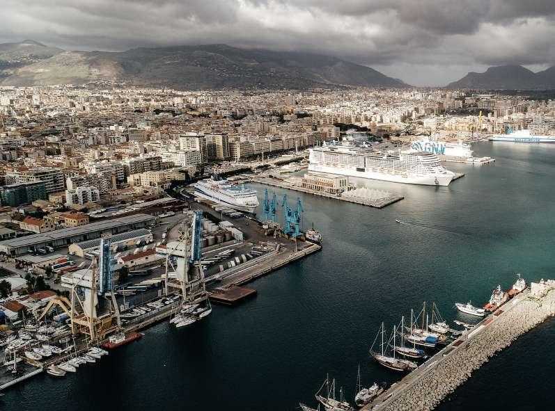
Pasqualino Monti, president of the Port System Authority of the Western Sicilian Sea (AdSP), presents the Port of Palermo “construction site” a little over three years after his appointment: projects and achievements, resources invested and spent, challenges that reconnect Europe with the Mediterranean by virtue of the policies and projects related to the TEN-T ScandinavianMediterranean corridor, a fundamental axis for the circulation of goods between the North and the South of the Continent. Palermo reconnects to the Highways of the Sea: to Malta, to North Africa and in particular to Tunisia and towards Algeria, but it also pays heed to Europe, doubling the Ro-Ro lines for Salerno, Livorno and Genoa, and connecting to Spain and France.
«Il porto è il luogo della relazione tra la città e il mare, è hub di innovazione, è il campo di applicazione di quella transizione ecologica che promuove forme di mobilità sostenibile e di ef cienza energetica. È un’industria vera, non contempla solo servizi, è economia reale». Pasqualino Monti, presidente dell’Autorità di Sistema Portuale del Mare di Sicilia Occidentale presenta il “cantiere” del porto di Palermo a poco più di tre anni dal suo insediamento: progetti e realizzazioni, risorse investite e spese, s de che riconnettono l’Europa con il Mediterraneo anche in virtù delle politiche e dei progetti che riguardano il corridoio TEN-T Scandinavo-Mediterraneo, asse fondamentale per la circolazione delle merci tra il Nord e il Sud del continente. Palermo si riconnette con le Autostrade del Mare: con Malta, con il Nord Africa e in particolare con Tunisi e verso l’Algeria, ma anche con attenzione all’Europa, avendo raddoppiato le linee Ro-Ro per Salerno, Livorno e Genova, e collegandosi con Spagna e Francia.
7
«The port is the place where the city meets
of application for the ecological transition that promotes forms of sustainable mobility
A smart port in the capital of Sicily, a benchmark of excellence among port infrastructures for many reasons: for having re-established a relationship with the local governments; for having built relations with international partners involved with the sea; for the synergies activated with private businesses to bring added value in terms of ef ciency and digitization; for the project to create a system between Palermo and Termini Imerese, within the context of the four ports
Un porto smart nel capoluogo siciliano, un’eccellenza tra le infrastrutture portuali per diversi motivi: per il rapporto recuperato con gli enti locali di riferimento; per aver costruito relazioni con partner internazionali del mondo del mare; per le sinergie attivate con i privati per portare valore aggiunto in termini di ef cienza e digitalizzazione. Ma anche per aver dato vita a un progetto di sistema tra Palermo e Termini Imerese, nell’ambito dei quattro porti di
8
competenza dell’Autorità di Sistema Portuale del Mare di Sicilia occidentale; per aver saputo intercettare e impiegare nella loro totalità le risorse europee.
«Recuperare e ricostruire una nuova relazione con la città. Per anni si era allargata una frattura tra la comunità e il suo mare, vissuto quasi con distacco, nonostante le grandi potenzialità di un tratto di costa di oltre 10 chilometri, che va dall’Arenella a Sant’Erasmo».
for which the Port System Authority of the Western Sicilian Sea is responsible; for having successfully captured and spent the totality of available European resources.
«To restore and rebuild a new relationship with the city. For years, the rift between the community and its sea, in many ways unquestioningly accepted, had widened despite the great potential for this stretch of coastline more than 10 km long, which extends from Arenella to Sant’Erasmo».
Pasqualino Monti sums up his mission as follows: «To return the sea to the citizens of Palermo and make it clear that the port is not a burden,
Pasqualino Monti sintetizza così la sua mission: «Restituire il mare ai palermitani e far comprendere che il porto non è una servitù, bensì una risorsa».

9
The context. Approved in the summer of 2018, the new General Plan for the Port (Piano Regolatore Portuale – PRP) is the instrument required to lay the foundations for the great infrastructure plan to make Palermo a competitive port. The PRP also includes the development of a green space that would reconnect the Foro Italico, Cala and the Castello a Mare.
Quays, dredging, consolidations to adapt to current technical standards, followed by the regeneration of the passenger terminal, and a new project for Ro-Ro ships. Within the framework of this operation, the Port System Authority of the Western Sicilian Sea was successful in obtaining European funding that would cover the fees for the nal and executive phases of the design of the project for the interface with the city.
Il contesto. Nell’estate 2018 è stato approvato il nuovo Piano Regolatore Portuale, strumento propedeutico all’avvio del grande piano di infrastrutturazione per fare di Palermo un porto competitivo. Il PRP prevede, tra l’altro, la realizzazione di un’area verde per riconnettere il Foro italico, la Cala e il Castello a Mare.
Banchine, dragaggi, consolidamenti per l’adeguamento alle norme tecniche vigenti, poi la riquali cazione della stazione marittima, e un nuovo intervento anche per navi Ro-Ro.
Proprio nell’ambito di questa operazione, l’Autorità di Sistema Portuale del Mare di Sicilia Occidentale è riuscita ad ottenere un nanziamento europeo nalizzato a coprire la quota di spese di progettazione de nitiva ed esecutiva dell’intervento di interfaccia con la città.
10
«Vogliamo dare un contributo fattivo per dimostrare che il demanio marittimo è una ricchezza e un’occasione di sviluppo, anche per far rimanere le nuove generazioni»
Pasqualino Monti, presidente dell’Autorità di Sistema Portuale del Mare di Sicilia Occidentale
11
«We wish to give a concrete contribution to prove that state-owned seaside properties are an asset and an opportunity for development, that might prevent the younger generations from leaving»
Pasqualino Monti, President of the Port System Authority of the Western Sicilian Sea
A New Identity for the City’s Waterfront
38
39
Una nuova identità per il waterfront cittadino
PROJECT AREA
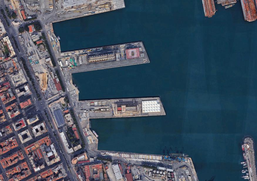
The lot designated for the project is located inside the port of Palermo and extends over a surface of approximately 52,000 square meters between Molo S. Lucia and Molo Vittorio Veneto. The road that runs along the area on the western side is Via Crispi. The lot is rectangular in shape, extending along the above-mentioned road.


AREA DI PROGETTO
Il lotto interessato dall’intervento è posto all’interno del porto di Palermo e si estende su una super cie di circa 52mila mq compresa tra il molo S. Lucia e il Molo Vittorio Veneto.
L’asse stradale che lambisce l’ambito sul lato ovest è via Crispi.
Il lotto presenta una forma rettangolare posta lungo la suddetta viabilità.
42
BEFORE AFTER
 by Emanuela Valle Architect and Partner
VALLE3.0
Il progetto di VALLE3.0 a cura di Emanuela Valle, progettista e partner VALLE3.0
44
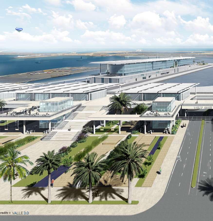
Following an international competition of ideas, the rm VALLE3.0 won the design of the regeneration of the port of Palermo, which includes the construction of the Ro-Ro terminal, a second terminal for cruise ships and the interface system with the city. Together these works, as a whole, will redesign a signi cant portion of the Palermo waterfront.
Concept. The structure on which the project is based is the product of a research study and analysis which led the architects to explore the foundational nature of the urban centre. The ndings showed that the con guration, typical of coastal settlements, had been modi ed over the centuries leading to a progressive separation between city life and the docks of the port. This evolution put an end to the regular dialogue between the maritime zone and the city and its inhabitants.
A seguito di un concorso internazionale di idee, VALLE3.0 si è aggiudicato la progettazione per la riquali cazione del porto di Palermo che comprende la costruzione del terminal per i traghetti Ro-Ro, un secondo terminal dedicato alle crociere e il sistema di interfaccia con la città. Tutti interventi che, nel loro complesso, andranno a ridisegnare una porzione importante del waterfront di Palermo.
Concept. La struttura su cui poggia il progetto è frutto di un lavoro di ricerca e analisi che ha portato gli architetti a studiare la natura fondativa del centro urbano.
Ne è emerso che l’impianto, tipico degli insediamenti sul mare, nei secoli è stato modi cato con il conseguente allontanamento della vita urbana dalle banchine del porto. Un’evoluzione che ha portato ad interrompere il dialogo quotidiano fra l’area marittima e la città e i suoi abitanti.
45
The Functions
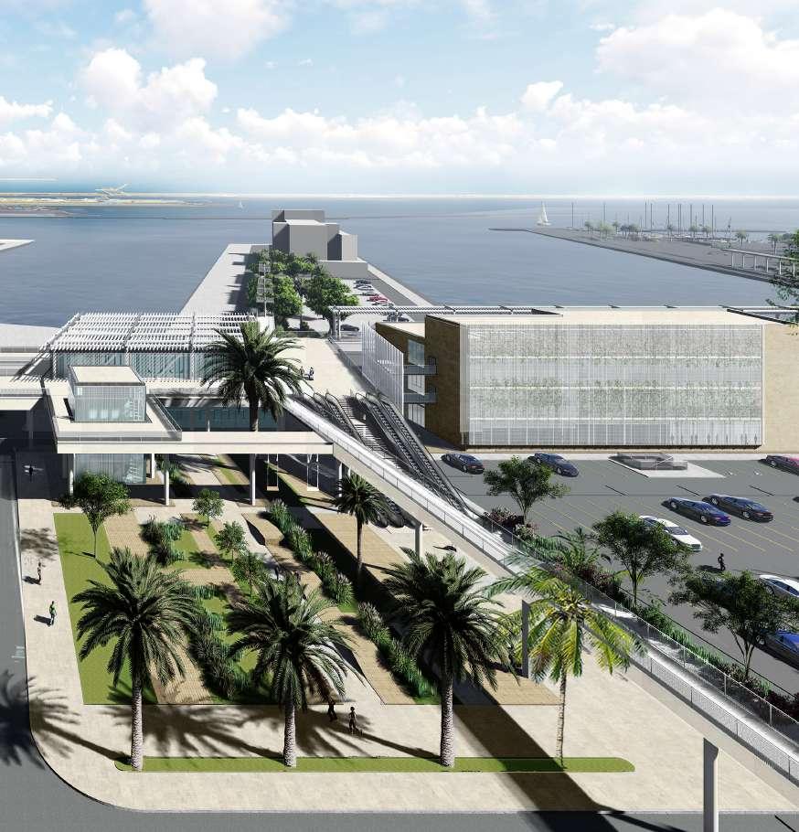
The system is articulated in a series of buildings with different uses which will offer services to both citizens and passengers moving “from or towards” the city. Its main elements are as follows: periscopes; ascending staircases; urban park; terrace on the sea, the walkways and commercial stands; ticket of ces, the of ces of the Police and Guardia di Finanza; street-level parking and underground parking garage; “Varco Amari” transit point; canopies providing shade.

LE FUNZIONI
Il sistema si articola in più edi ci con destinazioni d’uso differenti che vanno ad offrire servizi sia per i cittadini che per i passeggeri in transito “da o verso” la città.
Gli elementi principali sono:
i periscopi;
le scale di risalita;
il parco urbano;
la terrazza sul mare, le passerelle e i box commerciali;
le biglietterie, gli uf ci della Polizia e della Guardia di Finanza;
i parcheggi a raso e l’area di sosta interrata;
il “Varco Amari”;
la copertura ombreggiante.
50
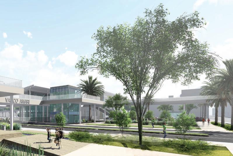
Of the six volumes de ned as periscopes, the two outer ones contain vertical circulation systems such as stairways and elevators, while the three distributed along the gardens house retail functions, the small size of which makes them reminiscent of Palermo’s typical kiosks. All the periscopes feature three levels, plus three internal levels that can host two different businesses: one on two oors serving the gardens, the other on the third level serving the terrace.
Dei sei volumi de niti periscopi, i due più esterni ospitano sistemi di risalita come scale e ascensori, mentre all’interno dei tre distribuiti lungo i giardini trovano spazio funzioni commerciali che, per le loro dimensioni ridotte, ricordano i tipici chioschi palermitani. Tutti i periscopi si sviluppano su tre livelli, con i tre più interni che possono ospitare due attività commerciali distinte: una sui primi due piani e a servizio dei giardini, l’altra disposta al terzo livello è invece a servizio della terrazza.
51
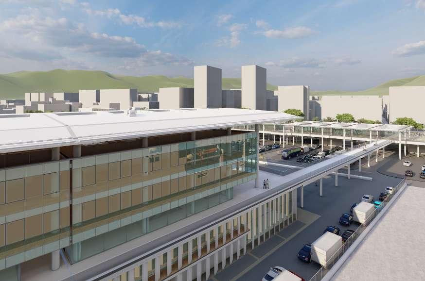
The vehicular and pedestrian traf c routes have been clearly separated, as have the access points for passengers on foot and the heavy goods-vehicle traf c. «This choice – explains Salvatore Acquista, Engineer and Project Manager for the Operation – was translated into “lifting” up everything that concerns pedestrian traf c off the ground, as demonstrated by the decision to raise all the functions dedicated to citizens and passengers to a height of seven metres above ground».
I ussi carrabili e quelli pedonali sono stati nettamente separati, come sono stati distinti gli accessi dei passeggeri pedonali dal traf co dei mezzi pesanti. «Questa scelta – racconta Salvatore Acquista, ingegnere e RUP dell’operazione – è stata tradotta nel “sollevamento” da terra di tutto ciò che riguarda la viabilità pedonale, come testimonia la sopraelevazione di tutte le funzioni dedicate ai cittadini e ai passeggeri alla quota di 7 metri d’altezza».
«The two-faced structure that serves as the interface between the city and the sea is the place where users change their status as they are “transformed” from citizens into passengers. As such, the goal of the area is to increase the permeability between urban and port spaces, without forgetting the safety requirements determined by the port functions»
Salvatore Acquista, Engineer and Project Manager for the Operation
«La struttura bifronte che funge da interfaccia rispetto alla città e al mare rappresenta il luogo dove gli utenti cambiano di stato “trasformandosi” da cittadini in passeggeri. Come tale, l’area ha la nalità di aumentare la permeabilità tra spazi urbani e portuali, senza dimenticare le esigenze di sicurezza determinata dalle funzioni dello scalo marittimo»
Salvatore Acquista, ingegnere e RUP dell’operazione
61
Pedestrian circulation. The vertical circulation systems (stairs, escalators and elevators) take the departing passengers up to the level of the terrace from which they can use the walkways to reach the Maritime Station, the Ro-Ro Terminal and the Cruise Terminal, where they can begin embarking procedures.
Vehicle circulation. Passengers traveling by car reach the port through the dedicated transit points of S. Lucia and Amari. «This serves as a preliminary checkpoint – underlines Acquista –beyond which the vehicles can proceed into the pre-collection areas, and when the time comes, go through the gates to be embarked. Heavy goods vehicles on the other hand will enter the port through the S.Lucia transit point only, and will gather in the large pre-collection area prior to embarking on the ferries».
I ussi pedonali. Attraverso i sistemi di risalita (scale, scale mobili ed ascensori), i passeggeri in partenza salgono al livello della terrazza e da qui, mediante le passerelle, giungono alla stazione marittima, al Terminal Ro-Ro e ai Terminal Cruise, dove possono effettuare tutte le procedure di imbarco.
I ussi carrabili. I passeggeri muniti di veicolo accedono al porto tramite i varchi a loro dedicati, il S. Lucia e l’Amari. «Qui viene effettuato un primo controllo – sottolinea Acquista – superato il quale i mezzi possono procedere nelle aree di pre-accumulo e, al momento opportuno, attraversare i gate per imbarcarsi. I mezzi pesanti, invece, accedono all’area del porto unicamente dal varco S. Lucia e si raccolgono sul grande piazzale del pre-accumulo che anticipa l’imbarco sui traghetti».
62

The SCAN-MED Corridor
Il Corridoio SCAN–MED
64
The Framework
Within a constantly changing global context, the Mediterranean Sea is back on track to play a primary role in the international competition, as a junction, a point of transit and arrival for trade ows that are increasingly important for the Euro-Asian and hence the global economy. This is born out by a series of initiatives. First and foremost, the Belt and Road Initiative, better known as the New Silk Road: the Chinese-led intercontinental project seeks in fact, with massive investments, to connect the most productive areas in Europe with the largest domestic market in the world, China.
Il quadro
In un contesto globale in continuo mutamento, il Mar Mediterraneo sta tornando a ricoprire un ruolo di prim’ordine nella competizione internazionale, in quanto snodo, punto di passaggio e atterraggio di ussi commerciali sempre più rilevanti per l’economia euro-asiatica e quindi mondiale. A testimoniarlo sono numerose iniziative. Su tutte, la Belt and Road Initiative, meglio nota come Nuova Via della Seta: il progetto intercontinentale a trazione cinese punta infatti, attraverso imponenti investimenti, a collegare le aree più produttive dell’Europa, con il mercato interno più grande del mondo, la Cina.
In questo ambito l’importanza del corridoio SCAN-MED risulta ancor più centrale e il motivo è chiaro se si guarda a un dato: circa il 90% delle merci scambiate in tutto il globo viaggia via mare.
65
Within this context the importance of the SCAN-MED corridor is even more crucial and the reason is clear when you consider one fact: about 90% of the goods traded around the globe
As far as Italy is concerned, the SCAN-MED Corridor starts at the Brenner Pass and connects Trento, Verona, Bologna, Florence, Livorno and Rome with the major urban centres of the South such as Naples, Bari, Catanzaro, Messina and obviously Palermo. The SCAN-MED, furthermore, involves nine of the fourteen Italian ports that belong to the TEN-T core network.
Per quanto riguarda l’Italia, il Corridoio SCAN-MED parte proprio dal valico del Brennero e collega Trento, Verona, Bologna, Firenze, Livorno e Roma con i principali centri urbani del sud come Napoli, Bari, Catanzaro, Messina e, ovviamente, Palermo.
Lo SCAN-MED, inoltre, interessa nove dei quattordici porti italiani appartenenti alla rete centrale TEN-T.
The overall volume of total goods transported along the corridor, based on the SCAN-MED
RFC data (Market study 2015 and SCAN-MED and CNC Work Plan 2018) is equal to approximately 70 million tons and is expected share” is 23%
I volumi complessivi di merci totali trasportate lungo il corridoio, dai dati SCAN-MED RFC (Studio di mercato 2015 e SCAN-MED e CNC Work Plan 2018) risultano essere pari a circa 70 milioni di tonnellate con una crescita prevista del 25% in 10 anni.
Il “loading share” italiano è del 23% ed è secondo solo a quello tedesco (48%) e seguito da quello austriaco (18%).
70
and is second only to that
7,527 km the length of the SCAN-MED corridor
7.527 km la lunghezza del Corridoio SCAN-MED
6 Countries it crosses produce 20% of the European GNP
The
I 6 Paesi attraversati producono il 20% del PIL Europeo with a surface area of 40% of the EU total e hanno una super cie di 1,6 milioni di kmq pari al 40% del totale dell’UE
71
Acknowledgements
si ringrazia
VALLE3.0 and the rm’s associates
Pts Clas spa
INEA, The Innovation and Networks Executive Agency
Georgia Aues Scek Mohamed
Translated by Olga Barmine


 by Emanuela Valle Architect and Partner


