

DESIGN PORTFOLIO
Richard Schutte 2025

CONTENTS
Wilson South: Downsview District Proposal
Fall 2024 | Instructor: Misha Bereznyiak | Individual Project
PreFabulous!
Spring 2024 | Instructor: Sam Dufaux | Groupmate: Olivia Bartolini | Awards: 2024 School of Cities
Embodied GHG Symposium 1st Place, 2025 CTBUH Mass Timber International Design Competition
5th Place
Pratt Institute: Higgins Hall Insertion
Fall 2021 | Instructor: Maria Denegri | Individual Project
Ha/f Seminar: UTSC Chemistry Building Whole Life Carbon Assessment & BIM
Fall 2022 | Instructors: Kelly Doran, Alstan Jakubiec | Groupmate on Climate Studio Work: David Yan
Aboretropolis: Downsview Forest
Fall 2023 | Instructors: Christos Marcopolous | Groupmates: Lhanzi Gyaltsan, Khadija Waheed |
Award: Professor Jeffery A. Stinson Graduate Student Endowment Fund
iCity 2.0: Downsview Hangar District Amenity Distribution Consulting
Spring 2024-Ongoing | Advisors: Robert Wright & Sara Diamond | Individual Work Shown
Air Quality Index Pavilion
Summer 2020 | Advisor: JP King | Groupmate Mina Onay | Award: 2021 Velux Design Competition: Americas - 1st place, Global - 2nd place
High-Rise Long Term Care: Salutogenesis, Agrotherapy, and Prefabrication
Fall 2024-Ongoing | Advisor: Stephen Verderber | Individual Project
Wilson South: Downsview Proposal

Wilson South district is a component of the larger Downsview Framework Plan. The site is currently a low density retail environment that is primarily parking and large footprint warehouses to serve the nearby suburban population. There is currently no official design for this area except considerations for a pedestrian bridge crossing south over the 401 highway to connect to Yorkdale Shopping Centre. This site is located in a critical position at the end of the Runway - “a continuous, linear publicly accessible open space and active mobility route, animat ed with vibrant uses including community uses and public amenities, while becoming a cultural destination for citizens from across the city and beyond”.
The Runway is a critical feature of Downsview which high lights the old airport runway space and terminates at large parks everywhere except the southern end. The goal of this project is to appropriately respond to site conditions and introduce an adequately dense, mixed use, exceptionally healthy, active, and authentic plan that has a novel and consistent identity.
Three core principles describe this proposed distict design: Animated, Harmonious, and Healthy.
Total Area of Typical Buildings: 144,815m2
Total Area of ‘Big Box’ Buildings: 158,615m2
Total Area of Condo Buildings: 102,558m2


1:1500 Site Roof Plan

1:2500 Site Use Diagram

Site
Isometric Rendering


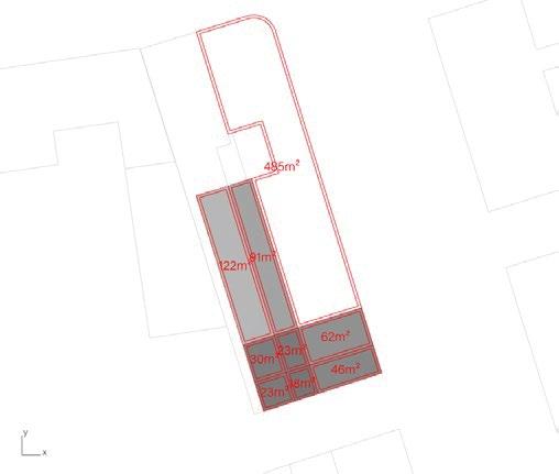
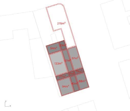
1:250 Block Plan

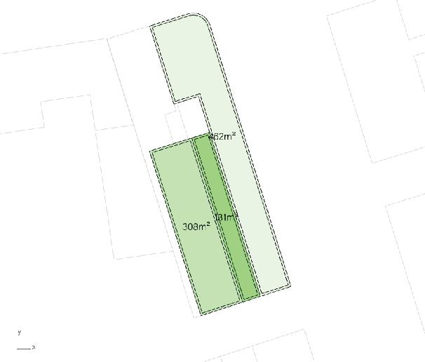
1:250 Block Section


PreFabulous!
single stair housing system


North-East building Isometric
This plug-in point access mass timber building system is an easily replicable and scalable solution for space sufficient, affordable housing that can be deployed on any site in Toronto’s hidden wealth of urban land. This “eco-system” employs a variety of unit types, connecting 3m tall, and 3x3.5m wide point-supported 5-ply CLT modules to create small but comfortable living spaces.
This system is repetitive but not generic, and guided by three constant principles which become the DNA of this system: 1. A green green terrace for every unit 2. A point-access circulation core nestled between two units on each floor 3. A tall services core that would support both our bathroom and kitchen modules for easy and quick construction.
(This addresses a primary issue with modular prefabrication that lies in the connection points of MEP systems between modules)


System DNA - Plumbing cores and circulation cores stack vertically

Transportation Diagram

Structural System - Glulam point-supported 5-ply CLT floors with stickframe partition walls
Module

Module assembly model photos


1:100 Exploded Isometric Diagram

1:50 Unit Plan ’A’

1:50 Unit Plan ’B’

1:200 Ground floor plan depicting permaculture planting scheme


’Farmer’s Market Cafe’ Illustration


East Elevation
Pratt Institute: Higgins Hall Insertion
Solar Optimization and Atrium Design


N/S Diagrammatic Section

Model photos


Iterations - View from above, red indicates winter


Ground floor lounge Rendering looking into atrium

Ha/f Seminar: UTSC Carbon Assessment
Solar Optimization and Atrium Design

Revit Model Perspective


Building carbon over time produced from One Click LCA (embodied
carbon) and Climate Studio (operational carbon)


1 : 20 S ec ti on 2 - C a ll o u t 1 1

Arboretropolis: Downsview Forest


Before Downsview Airport—and before Toronto’s urban monoculture was constructed—there was a native maple-beech forest that thrived for thousands of years. This project proposes a hybrid Miyawake-poplar afforestation technique to partially return Downsview to its pre-settlement forest state. Responding to Toronto’s desperate needs of both housing and natural forest area, a new urban form is envisioned merging a diverse ecosystem of building typologies with non-invasive branching road networks that allow the forest to grow into urban spaces. Transit-rich building clusters maximize walkability and provide access to the amenities of the 15-minute city, compressed into a five-minute urban forest.


District plan illustrating proposed building cluster and forest trails


Building ground floor callout illustrating retail and market spaces in forest clearing


District building use isometric diagram


in the forest’ trail rendering *produced in part with AI
’Streetcar in the forest’ streetview rendering *produced in part with AI
’Shipment


iCity 2.0: Hangar District Amenity Distribution
Introduction
Procedural visualization is an interactive method to visualize and support the analysis of often large urban datasets, making data comprehensible and actionable for planners and stakeholders. Procedural visualization, combined with optimization algorithms, supports iterative design processes. For instance, multi-objective evolutionary optimization enables the rapid generation and refinement of diverse design solutions, creating a positive feedback loop between computational outputs and human evaluation. It was used to connect complete community design principles, background research, and persona development with spatial design outcomes shared with the client.
Hangar District
Procedural Visualization was incorporated in this project through the development of adaptive decision support tools for the allocation of amenities and services across urban design scenarios and phases using complete community principles. Context amenities, such as grocery stores, pharmacies, and recreation facilities, were mapped using Google API in grasshopper to provide a baseline for what amenities already exist in the periphery. Based on complete community principles, best practices, amenity lists like that of Google’s or ESRI’s, and the developer’s specific needs, a list of 112 unique amenity categories was created.
A complete community would ideally include at least one of each of the 112 amenities to increase the diversity of amenities and the vibrancy of the streetscape by maximizing the number of amenities accessible to community members in the area. There is simply not enough ground floor space for an approach that only maximizes amenity diversity. This approach would not meet the needs of the community members, where health amenities like a pharmacy or community amenities like a library or co-working space may be more meaningful than others like a car dealership.

District Use Plan

Example persona zone breakdown


Personas
Personas were created based on demographic data and land use and each Persona was assigned a list of desired amenities from this complete amenity list, and an associated list of values that indicated the intensity of desire for each amenity. These values would serve as inputs such that amenities would be placed in zones with personas that wanted those amenities. Personas were not equally distributed throughout the site. Despite each zone being mixed-use, some zones would have a higher proportion of commercial or retail mix allocation due to building density and site conditions, and one zone was adjacent to suburban neighbourhoods and designated as having a lower density and a greater proportion of residential building types. The cumulative amenity needs for each zone were calculated by adding the amenity needs from each persona and creating a list of the most needed amenities. This approach al-lowed for persona amenity needs to be connected to spatial objectives for use in opti-mization as the first objective.
Clustering
The first optimization objective was to estimate and then respond to demographic needs through Personas, and the second objective was to appropriately cluster the amenities on the site. We considered the application of procedural visualization in additional case studies. One such example was a study where the amenities of 47 U.S. cities were located using Google databases. The amenity mix was compared across cities, then amenity clusters were categorized based on how likely amenities were to be grouped together [21]. We collected spatial relationships from case studies using Google Places databases and tweaked them to address complete community principles. These amenity clusters were procedurally allocated to the site, supporting a holistic analysis of high-performing amenity distributions that satisfied both the projected needs of the personas and amenity placement metrics.


Air Quality Index Pavilion


Section diagram illustrating glass sheet colour corresponding to pollution
Rendering of pavilion looking through curved stained glass sheets

Table depicting types of air pollution mapped in a range of colours representing healthy and hazardous conditions in selected cities

Section through curved glass walls and foundation

High Rise Long Term Care
Salutogenesis, Agrotherapy, and Prefabrication (Work in progress)
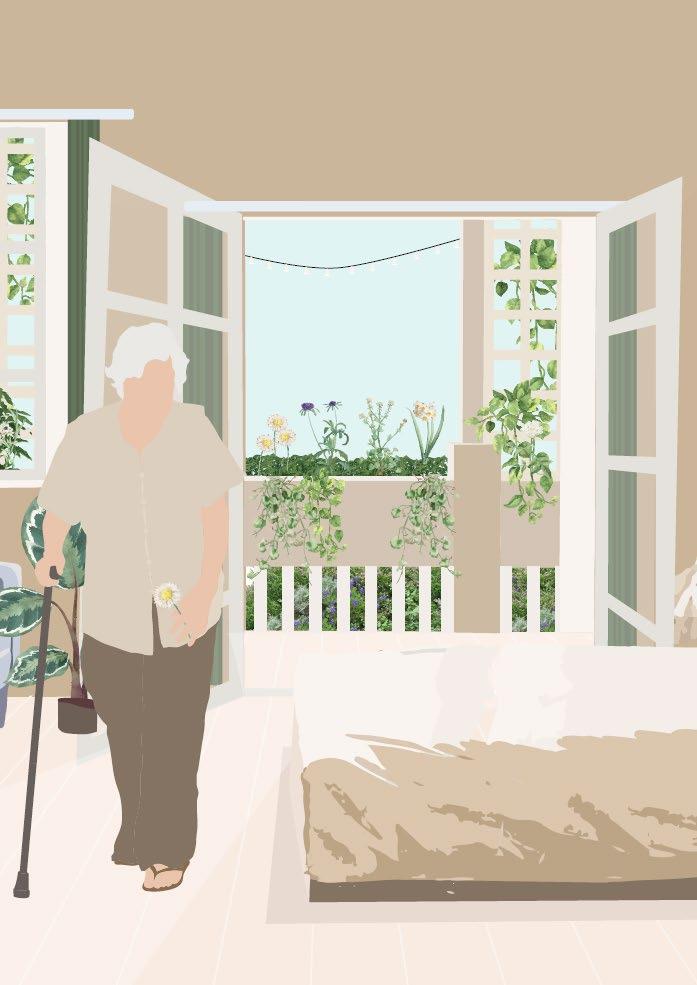
High Rise Long Term Care: Salutogenesis, Agrotherapy, and Prefabrication


Toronto’s proposed plan to respond to the long term care crisis is to renovate and construct new facilities but it is difficult to find adequate land to build on and nearly half of all LTC facilities need to be redeveloped. Substantial renovations or additions typically require the involuntary relocation of residents to another home during construction, but a shortage of beds can make this process even more difficult. 1 There is a significantly increased complexity of renovating long-term care homes to meet current standards as sprinkler upgrades, asbestos removal, water pressure, and electrical capacity upgrades require major renovations from specialized contractors across trades that are facing labor shortages. The construction of new facilities is made exceptionally difficult if adequate land cannot be acquired for a site, which is increasingly difficult as the need for housing has exhausted nearly every adequate site in urban areas like in Toronto.2
The ideal site for an urban long-term care facility is well-served by transit, green space, amenities, intergenerational opportunities, and neighborhood services, but such that the area is not already saturated with long-term care facilities. The demand for long-term care in Toronto is everywhere, but it is best if equally and proportionally distributed across the city as a function of population. It is important to reduce the distance from one’s community to the nearest long-term care facility to maintain one’s established connection to place, community, routine, and social support systems.
The process of selecting a site for this thesis prospectus involved a comprehensive mapping process of Toronto’s subway and streetcar infrastructure, population density, population density 65+, healthcare facilities, various amenities, and longterm care facilities. Several sites were found at the intersection of transit, amenities, and population density but in gaps found where there was an inadequate or complete lack of long-term care facilities.
The first site investigated was immediately south of the newly decommissioned Downsview Airport where Northcrest Developments is proposing a large housing development on the former airport runway and adjacent brownfield lands. This site was interesting as there will be a significant and con1 ‘Building and Redevelopment’. n.d. OLTCA. https://www.oltca.com/advocacy/building-redevelopment/. 2 Ibid.
stant influx of population, over 110,000 residents and 45,000 workers on the site that will be developed over the next 40 years. The site is transit-rich, amenity-rich, and walkable but after speaking to the Developers, I had found the only consideration was that there is currently a LTC facility on the site and no further facilities planned which meant there was a design opportunity to provide aging in place for the site’s future residents. However, there ultimately too many unknown factors with such a large project and timeline, and it was not selected.
The second site investigated was the parking lot of Warden Subway station with excellent access to nature, forested areas, walking paths, and a nearby hospital but there was already a large nearby non-profit long term care facility in the vicinity and plans to develop that parking lot with mid rise condos. The site was also insufficiently dense to warrant a high-rise building and so was rejected in the selection process.
The site that was ultimately selected is 495 Front St E, a currently vacant site adjacent to Corktown Commons. The site has undergone significant redevelopment, transforming from former industrial lands into a mixed-use community designed around a significant park. This 7.3 hectare park sits atop Toronto’s Flood Protection Landform (FPL) that acts as a flood barrier and sponge to prevent flooding in Toronto’s Financial District and the West Don Lands.3 Along with the park, the site is adjacent to mid rise condo buildings and separated from the Don trainyard and railways by an empty site currently used for industrial storage. This site is at a key intersection of a lack of LTC facilities in Toronto’s concrete-dominated downtown and the vast open space of Corktown Commons, the Don River, and Lake Ontario. The site is rich in history and exists at a critical moment in the development of Toronto’s downtown where every possible lot is being used for the construction of placeless and apathetic glass condo buildings rather than the services Toronto desparately needs. This site represents a significant opportunity to provide multigenerational mixed use long term care in a dense, well-connected urban site while providing residents with salutogenic design and agrotherapy through a wealth of indoor and outdoor gardens and agricultural amenities.
3 Bonnell, Jennifer L. 2018. Reclaiming the Don : An Environmental History of Toronto’s Don River Valley. Toronto: University of Toronto Press,. https:// doi.org/10.3138/9781442696808.


Richard Schutte 2025
