OUTCROP
Newsletter of the Rocky Mountain Association of Geologists


of the Rocky Mountain Association of Geologists
730 17th Street, B1, Denver, CO 80202 • 720-672-9898
The Rocky Mountain Association of Geologists (RMAG) is a nonprofit organization whose purposes are to promote interest in geology and allied sciences and their practical application, to foster scientific research and to encourage fellowship and cooperation among its members. The Outcrop is a monthly publication of the RMAG.
PRESIDENT
Matthew Bauer matthew.w.bauer.pg@gmail.com
PRESIDENT-ELECT Sandra Labrum slabrum@slb.com
1st VICE PRESIDENT
Nate La Fontaine nlafontaine@sm-energy.com
1st VICE PRESIDENT-ELECT Rachael Czechowskyj sea2stars@gmail.com
2nd VICE PRESIDENT Ali Sloan ali@sloanmail.com
2nd VICE PRESIDENT-ELECT Lisa Wolff lwolff@bayless-cos.com
SECRETARY Drew Scherer latirongeo@gmail.com
TREASURER
Astrid Makowitz astridmakowitz@gmail.com
TREASURER-ELECT
Walter Nelson wnelson@integratedenergyresources.com
COUNSELOR
John Benton jbenton@haitechinc.com
Rates and sizes can be found on page 49. Advertising rates apply to either black and white or color ads. Submit color ads in RGB color to be compatible with web format. Borders are recommended for advertisements that comprise less than one half page. Digital files must be PC compatible submitted in png, jpg, tif, pdf or eps formats at a minimum of 300 dpi. If you have any questions, please call the RMAG office at 720-672-9898.
Ad copy, signed contract and payment must be received before advertising insertion. Contact the RMAG office for details.
DEADLINES: Ad submissions are the 1st of every month for the following month’s publication.
The Outcrop is a monthly publication of the Rocky Mountain Association of Geologists
DESIGN/LAYOUT: Nate Silva | n8silva.com
EXECUTIVE DIRECTOR
Bridget Crowther bcrowther@rmag.org
LEAD EDITOR
Danielle Robinson danielle.robinson@dvn.com
CONTRIBUTING EDITORS
Elijah Adeniyi elijahadeniyi@montana.edu
Marlee Cloos marlee.cloos@bpx.com
Nate LaFontaine nlafontaine@sm-energy.com
RMAG CODE OF CONDUCT
RMAG promotes, provides, and expects professional behavior in every engagement that members and non-members have with the organization and each other. This includes respectful and inclusive interactions free of harassment, intimidation, and discrimination during both online and in-person events, as well as any content delivered by invited speakers and instructors. Oral, written or electronic communications that contain offensive comments or demeaning images related to race, color, religion, sex, national origin, age, disability, or appearance are not appropriate in any venue or media. RMAG reminds members of the diversity and mission statements found on our website. Please direct any questions to staff@rmag.org


MEMBERS
EVENT ATTENDEES
WEBSITE VISITORS
OUTCROP READERS
EMAIL SUBSCRIBERS
NETWORKING EVENTS
CONTINUING EDUCATION EVENTS
FIELD TRIPS
COMMUNITY CONTACTS IN 2024YOUR SUMMIT SPONSORSHIP DOLLARS SUPPORTED: 1,200 1,200 8,000 8,000 5,000 4,000 23 13 10


October 30, 2024
Geoscience Community:
We sincerely appreciate the support every Summit Sponsor and Event Sponsor provided over the past year. Your contributions are vital to the success of the Rocky Mountain Association of Geologists (RMAG).
In 2024, the RMAG was proud to host a dynamic lineup of events, including the CCS Workshop, which provided an in-depth look at advancements in carbon capture and storage. Members explored the beauty and geological wonders of the Colorado Rockies with ten diverse field trips and shared our passion for geoscience with students across the region through classroom visits and community festivals. Additionally, we fostered connections among members through monthly lunches, coffees, happy hours, and our annual Golf Tournament.
Looking ahead to 2025, we are excited about new opportunities for RMAG. Your sponsorship will help RMAG realize a robust calendar of continuing education opportunities, an exciting season of field trips, high-impact short courses, and a dynamic lineup of luncheon speakers. In April 2025, we look forward to the North American Helium & Hydrogen Conference, building on the success of our 2023 North American Helium Conference. Your sponsorship empowers RMAG members to impact the next generation at outreach events throughout the community and provides invaluable networking opportunities for the geoscience community. Furthermore, your financial support plays a crucial role in our publication efforts, which include the monthly Outcrop newsletter and the quarterly Mountain Geologist journal.
In recognition of your financial commitment to supporting geoscience in the region we recognize our sponsors through in-person signage, advertising on our website, publications, and social media promotions leading up to each event. With a LinkedIn group of almost 3,000 members, we ensure our sponsors are visible to the geoscience community for both virtual and in-person events.
Thank you to our current Summit Sponsors; we look forward to your continued support in 2025. For those considering sponsoring, we encourage you to explore the many benefits included at each sponsorship level and consider how you can promote geoscience in the Rockies. If an annual sponsorship doesn’t suit your company’s needs or if you wish to sponsor a specific event, please inquire about our single-event sponsorship opportunities. Feel free to reach out to our staff with any questions about sponsorship at bcrowther@rmag.org or by phone at 720- 672-9898 ext. 102.
On behalf of the RMAG staff, volunteers, and myself thank you all for your continued support, and we look forward to connecting with you in 2025.
Sincerely,
Matthew Bauer
Bridget Crowther 2025 RMAG President RMAG Executive Director


All sponsor benefits event tickets follow RMAG event registration deadlines. All benefits end 12 months after registration.
Platinum Sponsor
Gold Sponsor
Silver Sponsor
Summit Sponsorship benefit term is for 12 months! Specify type of payment on signed form, and send logo and advertisements to staff@rmag.org
Company:
Company Representative:
Address:
City: State: Zip Code:
Phone: Email:
Payment Method: Credit Card ACH Check
Credit Card Information:
Select Card: AMEX Mastercard VISA Discover
Name as it appears on Credit Card:
Credit Card #:
Expiration Date:
Signature:
Security Code:
ACH: contact the RMAG office at staff@rmag.org for directions.
Mail Checks payable to RMAG:
Rocky Mountain Association of Geologists (RMAG)
730 17th Street, B1 Denver, CO 80202
RMAG events are subject to change. Cancellation or rescheduling of events does not give the sponsor the right to refund. Summit Sponsors will receive benefits at any new events added into the RMAG schedule.
Thank you for your generous support!
P: (720)672- 9898 staff@rmag.org www.rmag.org

730 17th Street, B1 Denver, CO 80202
By Drew Scherer, Secretary flatirongeo@gmail.com
Happy New Year and welcome to the January 2025 edition of The Outcrop by the Rocky Mountain Association of Geologists. The Board of Directors met on December 13th, 2024, live and in-person at the Denver Earth Resources Library. All board members, except one, were present at the meeting. We welcomed two new members to the board for the 2025 year, John Benton, and Rachel Czechkowskyj!
Bridget began with an overview of general organization news, notably we had 4 events to close out the year, while the attendance was smaller around the holidays, the luncheon was still well attended. We also recalled the great attendance we had with our Western Slope members at the Grand Junction Happy hour. In November we crossed the 1200 member milestone which is a great indicator of our recent membership efforts. The finance committee reported that revenue was a bit light this month, owing to no big courses or
symposiums; operating and personnel expenses were as expected. Our investment account posted a large gain, which offset the losses incurred in the investments last month which was also great to hear.
The Continuing Education Committee focused on closing out the year with a great luncheon with an attendance of 78 total (online and in-person), and is setting up talks and courses for the new year including putting in a lot of hard work to plan the Hydrogen-Helium conference on April 9-10. The CEC also has a Oil & Gas + Energy Transition Career Fair in the works to engage local students in the Workforce and provide resources to Members in Transition. Speaking of which, Jason Eleson and Chris Shaw have been working on a soon to be released skills matrix to help geoscientists decide where best to apply their core geoscience skills over their career including how those traditional skills fit into Oil & Gas, Mining, Environmental, and Low Car-


Lastly, the publications committee met to go over their first three Outcrop issues of the new year and brainstormed upcoming Outcrop article ideas. Danielle Robinson is also taking over as the lead editor of the Publications Committee from Nate LaFontaine starting this month. The Membership, Geoscience Outreach, and On the Rocks committees did not meet in December, and will instead resume their meetings in January. To close out the meeting the board approved the 2025 RMAG budget, including the personnel compensation bud-
We are looking forward to a great year here at RMAG and hope you are too. If you have any geoscience-related New Year’s resolutions we would love to hear them. Email Drew Scherer (RMAG flatirongeo@gmail.com for a chance for your resolution to be featured in the February 2025 Outcrop


By Matthew Bauer
Dear Fellow Members,
The Rocky Mountain region has experienced multiple phases of mountain building, erosion, and fluid migrations so it’s no surprise it hosts conventional, unconventional, metal, and non-metal resources. RMAG serves a region with diverse geology and many geoscience practices so it’s had many great minds that have called RMAG their home geologic society; some more well known than others. As a member of RMAG, you know that our organization is volunteer-run and dedicated to promoting geoscience. Founded in 1922 and being primarily energy focused these last 103 years our membership has
experienced the ebb and flow of disciplines tied to commodity markets and the world economy. Much like sediment moving from the hinterland to areas of more accommodation, jobs have also come and gone bringing our members to follow new opportunities in different areas across our great nation; and sometimes, the globe.
How do we serve our members best? One way is by understanding where our members are located and how we can better cater to them. Long before “Data Scientist” was a career path, geoscientists have been making sense of spatial data. A little over a year ago we utilized a bit of python code, Google Maps API, and QGIS (an open-source GIS program) to visualize the geographic distribution of our membership. We utilized a technique called ‘choropleth mapping,’ essentially making heat maps, that show where our members are located. This is helping us identify areas of high concentration so we can better understand how to organize events and reach out to members in the most effective ways. I’d like to share some insights and findings from that effort.

In Figure 1, you can see a map that shows the distribution of RMAG membership across the United States. As expected, the majority of our members are located in Colorado. However, several pockets of significant presence exist in Texas and Oklahoma. In Figure 2 of a bar chart of the top 20 states for RMAG membership we can better see the amount of membership per state. Much like Figure 1 we see concentrations of RMAG members aligning closely with the energy hubs across the US and Canada.
Now that we have a better


FIGURE 1: (above)
Choropleth map with a modified Virdis color map of RMAG membership across the United States of America.
FIGURE 2: (left)
Top 20 states for RMAG membership.

understanding of where the regions of our members are located, let’s dive deeper into how this data helps us tailor events and services for you. Figure 3 shows the top 20 cities for RMAG members. As no surprise we have Denver as a center of membership. As my wife would say “You can’t throw a rock in Golden without hitting a geologist!” and Golden, Colorado comes in as the second highest for membership. Looking at Figure 4 we can see trends in the choropleth map of the distribution of membership within Colorado following the front range and highlighting many populated areas across the state. Zooming into the Greater Denver Metropolitan area in Figure 5 the choropleth map shows a distinct concentration downtown. Many members have their billing address at work so daytime membership is high in the center of the city and it is equal distance to many of the suburbs. Hence downtown Denver is the hub of our daytime events including coffee and lunch lectures. The central, southeast, and western side of the metro all are home to high concentrations of membership. While we step out to other locations for happy hours we host a majority of our evening social events in these concentrated membership areas.
Moving back out to a wider view. We are proud
to have RMAG members not only across the United States but also in Canada, Saudi Arabia, Australia, China, and Norway. As shown in the bar chart of the countries represented in membership in Figure 6 this international presence speaks to the widespread impact and relevance of the Rocky Mountain region’s geology on a global scale.
Observing trends in membership has helped us


over this last year to better understand and serve our membership across 6 countries and 42 states. I believe that RMAG, being led by volunteers, strives to fulfill our goals, offers a high value of membership to our members, and a positive influence to the 275 communities in which we live. I grew up in a rural community in Missouri, where geoscience exposure wasn’t widely available. However, a high school history teacher, Karl Mayo, with a passion for rockhounding, inspired me to explore geoscience as both a hobby and a career.
We encourage you to think about how you can contribute to your community. Whether it’s by participating in an upcoming event, helping out with a project, or simply sharing your geoscience passion with the next generation, there are many ways to make a positive difference for your own experience while improving others’. Who knows; someday a young person you inspired may be an RMAG member making discoveries of their own and reading in The Outcrop about where their fellow RMAG members live.

6: Distribution of RMAG membership across the six represented countries.
Stay Curious & Be Good to People, —Matthew W. Bauer, PG
P.S. For those of you with a curious mind and a penchant for data, I’ve posted the Python code I used to geolocate our membership. If you’re interested in exploring this on your own, you can find it on my GitHub: github.com/Rocks-n-Code.


How the Spanish Peaks and Colorado High Plains came to be
BY SABRINA KAINZ • skainz@uw.edu
and stepped out of Denver International Airport for the first time, there were a couple things that stood out to me. Firstly, where are these mountains everyone talks about? The taxi rank looked out onto dry plains as far as the eye could see. Second, why did I get winded walking up a flight of stairs? For being on such a flat piece of land, DIA is at a surprisingly high altitude (5,434 ft or 1,656m). As I leant how to live at a mile high, I also learnt that much of the Denver Metro Area is located at the edge of the High Plains, a geographic region that sits at abnormally high elevations for a place that isn’t located in a mountain range.
The geologic history of both the Southern Rocky Mountains and the High Plains is a fascinating, yet puzzling question for geologists to think about. This region has not been in a tectonic mountain building event for over 50 million years, yet its mean elevation is comparable to that of many active mountain ranges around the world. Moreover, the High Plains are higher than any other piedmont adjacent to a mountain range. The piedmonts adjacent to ranges like the
Himalayas, Andes, and Pyrenees typically drop to less than 500m elevation within around 50km away from the mountains’ base. However, the Colorado High Plains stay high above 500m as far as to the Kansas border (more than 400 km away). This impressive, yet unexplained, phenomenon begs to ask, how did the High Plains get so high?
We probed this question by turning our attention to the Spanish Peaks (Wahatoya in Comanche) of southeast Colorado. The Spanish Peaks have been the markers at the end of the High Plains for many groups throughout history. As part of the territory of the Cheyanne, Jicarilla Apache, Comanche, and Ute people, the Spanish Peaks have long marked where travelers have finally reached the mountains after traversing hundreds of miles of plains. To quote a diarist who traveled along the Santa Fe Trail “jagged peaks are towering in mid-heaven all around us… grand beyond description” (from Blood and Thunder by Hampton Sides)
Although the Spanish Peaks are geographically considered part of the Southern Rocky Mountains, they are geologically distinct from any of Colorado’s mountain ranges. While the Sangre de Cristo range rises to their west and the Wet Mountains rise to their
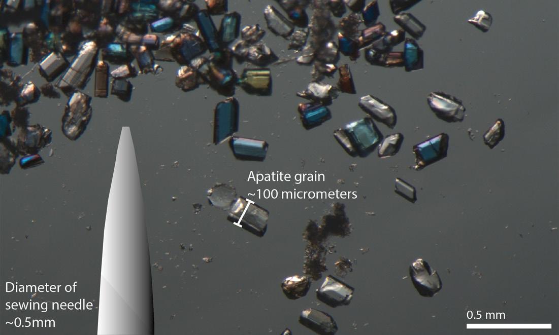
FIGURE 1: Apatite crystal used for measuring Uranium, Thorium and Helium isotopic ratios to understand the time of cooling in rocks.
FIGURE 2: Uranium-Thorium Helium dating tells us when apatite minerals within the Spanish Peaks plutons cool below 70°C and is therefore used as a proxy for erosion.
north, the Spanish Peaks are special in that they stand alone at the border between the High Plains of Southern Colorado and the Rocky Mountains. This isolation is due to their unique geologic history that begins 24 million years ago, when they were emplaced as plutons during the Ignimbrite Flare-up, a violent episode of volcanism responsible for the formation of the San Juan Mountains to the west. The Spanish Peaks are shallow igneous plutons - cooled magma chambers that would have once been sitting deep underground. Standing atop of West Spanish Peak, hundreds of dikes radiated away from the peak, a relic of magma injecting into the surrounding soft sediment that has now been eroded away leaving the dikes,standing like fins throughout Huerfano County.
Now sitting at 13,631 and 12,688 feet high respectively, East and West Spanish Peaks have been significantly exhumed from their emplacement deep below the surface. Having been emplaced after the end of the Laramide Orogeny, Colorado’s last big tectonic mountain building event, the question is raised: how did they reach their great heights, and what does this mean for the rise of the High Plains. To solve this, we look to the thermal history of the rocks.
While there are many different types of thermochronology, the data from this study comes from measuring isotopes of U and Th decaying in the mineral apatite (Figure 1). Apatite is a trace mineral formed during crystallization from most types of melt, making it likely to be found in most silica-based rocks. It is also the biomineral that makes up part of our teeth! As radioactive uranium and thorium decay to lead, alpha-particles (Helium-4) are produced. Alpha-particles will typically escape out of the crystal when its temperature is high, but when cooled below around 70°C, the crystal retains the alpha-particles (Figure 2). When the rock cools below this ‘closure temperature’, the isotopic clock begins ticking as helium particles build up in the mineral.
This cooling of rocks below 70°C can be triggered by a number of geologic phenomena. In the case of the High Plains, we use cooling as a proxy for erosion of rocks triggered by uplift of the region. As the area rose,
soft sedimentary rocks that once surrounded the resistant Spanish Peaks eroded away. The emerging peaks became isolated Apatite thermochronology tells us when this uplift and exhumation occurred.
Research from this study was conducted in Dr Rebecca Flowers’ Thermochronology Research and Instrumentation Lab at the University of Colorado Boulder (CU TRaIL). The five samples we collected down the flank of East Spanish Peak reveal that a 1.5 km thickness of sedimentary rocks was eroded over a 2–5-million-year duration; that’s a fast rate for a region located far away from an active plate boundary (Figure 3). The very top of East Spanish Peak cooled below the 70°C isotherm by 16-18 Ma, marking the first record of exhumation of the peaks (Figure 4). This erosional event likely started before this time, but the lack of information from elevations higher than 13,000ft make it impossible to know exactly when it started. This is an impressive amount of material that had to have eroded away, stacking nearly 1.5-2km atop the already tall Spanish Peaks (Figure 5). By 14 Ma the lowest sample, from a radial dike a couple miles down the road from the beautiful town of La Veta, was sitting at 1.5-2km below the surface. Rates of exhumation this great are thought to be associated with fast growing mountain ranges, such as the Himalayas, where increasing elevation from plate-driven uplift causes faster rate of erosion due to exposure to more intense weather-driven erosion.
We looked beyond the Spanish Peaks to tell a broader story of the High Plains’ history. To understand how widespread in time and space the Spanish Peaks erosional event was, we must look further away from its locus. We also dated four smaller igneous intrusions (the Apishapa Dikes), one being the famous Huerfano Butte. The butte, which is made up of three separate mafic dikes, marks your arrival in the Spanish Peaks region when driving south on I-25 (Figure 3). While not as big or as stunning as the Spanish Peaks, these intrusions are crucial for constraining exhumation of the High Plains further east, away from the mountain front. The Apishapa Dikes show that erosion continued over this area till at least 5 million years ago and was experienced at least 40 kilometers east of the

FIGURE 3: Data from Kainz et al., 2024. AHe indicates apatite Uranium-Thorium-Helium thermochronology samples dates, the time at which the sample cooled below 70°C. 40Ar/39Ar and K-Ar dates are emplacement dates, the time at which the sample was crystallised from melt (Penn and Lindsey (2009)). SDC = Sangre de Cristo Range, WM = Wet Mountains, WSP = West Spanish Peak, ESP = East Spanish Peak, GHM = Greenhorn Mountain.
4: Evolution of the Southern Colorado High Plains as inferred from thermochronologic data.


Spanish Peaks (Figure 4)
The final key sample in this study is Two Buttes, located nearly 200km east of all the other samples, close to the Colorado-Kansas border (Figure 3). The modern elevation here is around 4,700ft. The most intriguing story behind Two Buttes’ erosional history is the fact the Ogallala Formation currently surrounds the intrusions. The Ogallala Formation is a unit that contains the famous Ogallala (or High Plains) Aquifer that provides water for many of the states in the Great Plains region. It is thought to have started depositing from the runoff of the mountains to the west at around 9-12 million years ago. This means that Two Buttes had to have been exposed the Earth’s surface by 12 Ma to be currently adjacent to the Ogallala. This is confirmed by our apatite helium thermochronology date of 27 Ma, a date much older than those recorded elsewhere in the Spanish Peaks region, indicating a much earlier end to erosion near the Kansas border. At 12 Ma time, the Spanish Peaks and Apishapa Dikes were still undergoing erosion, telling us that erosion stopped further east earlier in time than in the Spanish Peaks region, and that the magnitude of erosion was
significantly greater closer to the foothills (Figure 4)
Timing is everything when it comes to understanding landscape evolution, which is what makes geochronology such a powerful tool. Now that the timing of exhumation in the Southern Colorado High Plains has been constrained to an episode around 18-5 million years ago with a focus around the Spanish Peaks region, we can theorize as to the mechanisms behind localized uplift.
Given that the most recent mountain-building event, the Laramide Orogeny, ended by ~45-55 Ma, we can eliminate exhumation caused by orogenic uplift (Figure 6). Normal faulting, which commonly triggers substantial exhumation, has been active across much of Colorado during the Neogene, but no high displacement normal faults have been mapped that can plausibly explain the broad exhumation signal we have measured.
The other option is vertical displacement, an epeirogeny, not directly related to action along tectonic margins. One way to vertically displace is by heating

Denver, Colorado ~ April 9-10, 2025
EARLY BIRD UNTIL 2/15/2025:
RMAG MEMBER - $600
NON-MEMBER - $700 AFTER 2/15/2025:
RMAG MEMBER - $700
NON-MEMBER - $800
INCLUDES BOOTH, REGISTRATIONS & ADVERTISEMENT
up the mantle below the High Plains, causing bowing up of overlying lithosphere, as the hot rock expands towards the surface. There are four ways in which we theorize this can happen:
1. Break off of the Farallon Slab at the end of the Laramide Orogeny. As the cold, dense subducting plate sunk into the mantle below Colorado, hot mantle flowed in to take this space.
2. Ignimbrite Flare-up volcanism was occurring from 37 to 23 Ma which led to mantle heating and emplacement of numerous igneous intrusions. This volcanism may be another heating source capable of raising the High Plains.
3. Rifting has affected Southern Colorado starting at 28 Ma in the Rio Grande Rift Valley (Figure 6) As the lithosphere pulls apart, cold lithosphere is replaced by hot asthenosphere, causing a thermal bulge capable of uplifting a large region. The classic example of this is seen in the East African Rift Valley, where low topography plains are seen at high elevations. The city of Nairobi sits at 5,889 feet above sea level, higher than even Denver.
4. A theoretical mantle drip. Like how a water droplet on a cave roof can slowly build up mass before dripping off quickly into the less dense air below, so can the cold lower lithosphere ‘drip’ down into the warmer mantle below. Replacement of colder lithosphere with warm asthenosphere will cause thermal expansion of the remaining lithosphere, which rises. An event like this could explain the center of exhumation we observed that is localized in the High Plains of southeastern Colorado and whose magnitude diminishes as you move away from its center, where the greatest amount of erosion is likely to take place. While this is a theoretical model, it does explain the pattern of exhumation recorded by our thermochron data and better matches the exhumation timing than do the other hypotheses. For this reason, our team favors the mantle drip model.
It is important to note that while this data tells us a lot about southeast Colorado, interpretations we draw as to how such a rapid amount of exhumation occurred are still tentative. The Spanish Peaks are just one part of the puzzle. The mystery behind why the High Plains
FIGURE 6: Geologic events in Southern Colorado since 68 Ma. The Spanish Peaks Erosional Episode does not line up temporally with any established events in the region’s history.
are so high remains an intriguing question that geologists will continue to study through thermochronology, seismology, landscape modelling and more.
I encourage you to think of how much the elevation of the High Plains influences the day-to-day lives of those who live there. From the afternoon thunderstorms we see roll in from the east to the baking Winter sun we experience, the geology of the High Plains influences more than at first glance. While the High Plains may not be as impressive a sight as their neighboring mountains, they tell a geologic history just as incredible and probably more puzzling. We live in a truly unique setting that contains many wonders of Colorado’s past. And when you next see the Spanish Peaks, as high as they are, think of how the land surface 20 million years ago was towering kilometers above their peaks.

Speaker: Rachael Moreland
Date: January 8, 2024 | 12:00 pm - 1:00 pm

Presenter: Rachael Moreland
As the energy industry navigates a pivotal year, 2025 promises to be shaped by a dynamic interplay of market forces, technological advancements, and geopolitical realities. Let's explore the state of the energy industry as we enter the new year, with a focus on North America as a critical hub for innovation, production, and policy shifts.
Key topics will include the outlook for oil
and gas markets amid the ongoing energy transition, the role of advanced technologies like AI and automation in optimizing operations, and the impact of shifting demand patterns and international policy frameworks. We'll also explore the influence of renewable energy integration, challenges in securing supply chains, and strategies for achieving both profitability and sustainability in a dynamic market.
RACHAEL MORELAND is a leading product management expert who believes in bringing people together to connect, collaborate, and innovate. She currently serves as Vice President of Global Energy Software & Advanced Analytics at S&P Global. She also serves on the board of directors for Energy Outreach Colorado, a nonprofit dedicated to ensuring energy affordability for all Coloradans. In early 2024 she was recognized as one of the Top 50 Women of Impact in Tech for her ability to craft and execute transformative strategies that drive business growth in high-tech, matrixed organizations. She believes in the power of diverse perspectives to fuel creativity, and her leadership philosophy is grounded in fostering a culture of trust and empowerment.
D eta ile d a nd ac c ura te g eo lo gy at yo u r fin g ertip s in Pe tra , Ge o Grap h ix, A rc GIS , A cc u Map , ge o S C OU T an d o th er d ig ital ma p pin g a p plica tion s
We ste rn USA
Geol ogi cal Edge Set
Ene rgy Al te rnati ve s & Cri ti cal Mine ral s - USA
We ste rn Cana da Geol ogi cal Edge Set
Ene rgy Al te rnati ve s & Cri ti cal Mine ral s - Ca nada
Ea ste rn USA & Ea st ern Ca nada
Geol ogi cal Edge Set
Cent ral USA
Geol ogi cal Edge Set
Me xi co
Geol ogi cal Edge Set
Map la ye rs p rov ided in s ha pe file fo rma t fo r ea sy impor t into a ll ma ppin g app lic at ions .
De liv er ab le s inc lude : f orma tion limits , o utc ro ps, su bc rop e dge s , O &G fie ld s, st ruc tu ra l eleme nt s, re ef s, sh ore lin es , c ha nne ls, pro duc tion f airw a ys , s ha le ga s tr en ds, st ru ct ure con tou rs , iso pa chs , g en era l cult ure , r ene w able & no n-r en ew ab le ene rg y pr ojec ts , min era l dep os it s, mine s, Pet ra T he mat ic Ma p pro je ct s, G eoG ra phix G e oA tla s pro je c ts , Ar cG IS M XD a nd La y er f ile s, re giona l c ro ss -s ec tion s, an d full te ch nica l s upp ort .
For mo re inf orma tio n: Joe l H a rding at + 1 4 03 87 0 8 12 2 joe lha rding@ g eoe dg es .c om ww w.ge oe dge s.c om
Speaker: Eric Stautberg
Date: February 5, 2025 | 12:00 pm - 1:00 pm
And a case study on exploration for hot sedimentary aquifers on the Texas Gulf Coast
Presenter: Eric Stautberg, Colorado School of Mines
The United States generates approximately 3.7 gigawatts (GWe) of geothermal electricity every year, however, this only accounts for 0.4% of the total power generated and consumed by the U.S. Consequently, exploring for and developing new geothermal resources to increase this percentage is of upmost importance. Geothermal resources for electrical power generation can be classified into three broad categories: conventional hydrothermal, enhanced geothermal systems (EGS), and hot sedimentary aquifer (HSA). These three categories differ in thermal energy and fluid type, with conventional hydrothermal being the hottest (>350⁰F) and typically vapor dominated, EGS systems have moderate temperature (300-350⁰F) and are usually dry rock, and hot
sedimentary aquifers are mostly classified into the low temperature category (200-300⁰F). The variability of these systems leads to different challenges and methodologies when exploring for and developing these resources. The passive margin of the Texas Gulf Coast is a basin that contains numerous hot sedimentary aquifers of varying age, lithology, and reservoir temperature. Identifying and classifying the different sedimentary geothermal play types that contain HSAs is a pivotal part of exploring for geothermal resources in this region. This presentation will discuss the different geothermal play types identified in south Texas through subsurface petrophysical and temperature mapping and provide an introduction to the different types of geothermal systems.
ERIC STAUTBERG is a Ph.D. candidate at Colorado School of Mines in the Department of Geology and Geological Engineering. His research is focused on identifying and characterizing low temperature geothermal play types on the Texas Gulf Coast for utility scale electrical power generation and direct use applications. Prior to being at Colorado School of Mines, he spent seven years working in oil and gas exploration at Anadarko Petroleum Corporation and Occidental Petroleum Corporation (Oxy) on the Gulf Coast and in the Permian Basin. At both Anadarko and Oxy, he was tasked with generating prospects and drilling horizontal exploration wells across the Gulf Coast and in the Permian Basin. In 2013 he completed a M.Sc. in Geological Sciences from the University of Texas at El Paso where he worked a field-based carbonate sedimentology and stratigraphy project in southern New Mexico and west Texas. He also has a B.Sc. in Geology from Texas A&M University and worked as a NAGT field intern at the U.S. Geological Survey. Eric is passionate about applying oil and gas exploration techniques to geothermal exploration in sedimentary basins.


By Denise M. Stone
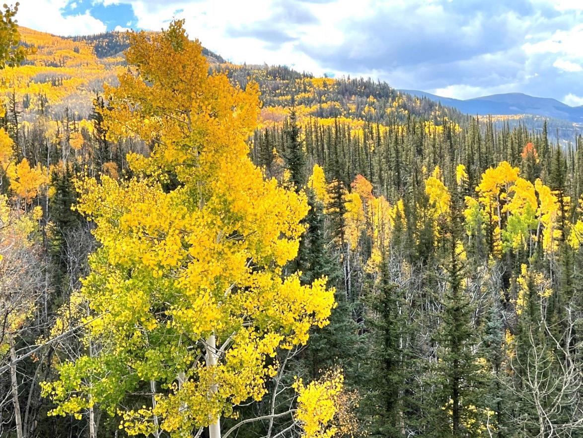
On Saturday, September 28, an enthusiastic group of RMAG members and guests gathered in Lake City, Colorado, to learn about the geology of the San Juan volcanic area and environs. We examined Tertiary volcanic rocks of the expansive Lake City Caldera most of the day: tuffs, ignimbrites and rhyolites. As the afternoon progressed towards sunset, we studied a most unusual geomorphic feature, an active “earthflow.“ All of the features on our field trip had been sculpted by Pleistocene glaciation. The frosting on the cake was a magnificent landscape topped by golden aspen trees at vibrant peak color.
With morning temperatures in the 50’s, our group of 22 mustered beneath a clear blue sky at the Matterhorn Hotel in Lake City to begin the trip. The night before, trip leader Harvey DuChene and his wife, Kathy, hosted us for an ice breaker and snacks in their home on a bluff overlooking the Lake Fork of the Gunnison River. We had no idea at that point how fabulous the next day would be.
The focus of our one-day field trip was the Lake City Caldera. In every direction there was a volcanic landscape developed over a giant Cenozoic caldera complex subsequently heavily modified by Pleistocene glaciation creating lots of spectacular topography and scenery. This trip was one of the “overnighter” trips offered in RMAG’s 2024 field season and it didn’t disappoint.
Lake City is located west of the Continental Divide, southwest of Gunnison and can be reached by
Colorado state highway 149. The town was founded on Ute Indian land by Enos Hotchkiss after the tribe ceded the land to the United States in 1874. The prospect of gold and silver attracted miners seeking their fortunes to the area. However, by 1900 the mines began to decline significantly, and today there are no active mines in the area.
It was quickly clear that the volcanic complex laid out at our feet and extending to the horizon was a large feature. The Lake City Caldera is just one of several large calderas that make up the San Juan Volcanic Field, the eastern half of the San Juan Mountains. We were surprised to learn that the famous Yellowstone Caldera is not the biggest volcanic complex in the continental US as measured by the volume of volcanic ejecta. The La Garita Caldera, the largest of numerous calderas in the San Juans, has alone ejected 5000 cubic kilometers of volcanic material, larger by a factor of five compared to Yellowstone’s 1000 cubic kilometers. Its primary period of activity was 27.8 million years ago. The Volcanic Explosivity Index (VEI), which ranges logarithmically from 1-10, depicts the explosiveness of any given global volcanic eruption. On this scale the La Garita eruption scores a huge 9.2.
Chemical weathering of Lake City Caldera volcanic ejecta, mainly tuff, is responsible for the formation of the Slumgullion Earthflow. The tuff, when saturated with acidic hydrothermal waters, alters to montmorillonite and smectite clay, creating a

FIGURE 1: Golden aspen trees covering the mountain slopes on Wolf Creek Pass enroute to Lake City, Colorado, destination of the San Juan Mountains field trip.

product susceptible to a mass wasting phenomenon known as an earthflow. As the clay absorbs rain and melt water, the clay mass volume increases and loses cohesion. Motion is initiated and the earthflow slowly moves downslope due to gravity, like a glacier, deforming and entraining what is in its path. At the Slumgullion Overlook we could see small, deformed trees trying without long term success to root and grow. This spectacular earthflow has been active possibly for over 1000 years.
Glaciation was active in the San Juan Mountains from the beginning of the Pleistocene Epoch. U-shaped valleys were formed through the volcanic terrain generating the jagged peaks and landforms seen today, including several 14ers. Henson Creek was a major route for glaciers during the Pinedale glaciation (maximum extent about 23,500 to 21,000 years ago); its glacier was nearly 16 miles long. The dimension and scope of glacial valleys was strongly influenced by the type of bedrock beneath the ice and its mechanical integrity.
Trip Leader Harvey DuChene told us he first became interested in the San Juan Mountains when
FIGURE 2:
Location map of Lake City, Colorado, the RMAG field trip destination. From Denver it is roughly six hours by car through scenic landscapes of rugged mountains, alpine valleys and glacially sculpted terrain. The group had the added beauty of late September golden aspen trees along the drive.
he was a pre-teen on a road trip with his family from Michigan to southern California. This experience eventually led him to study geology in college, specializing in petroleum geology, stratigraphy and structural geology. While prospecting as a petroleum geologist, Harvey spent much of his spare time hiking the peaks in the San Juans with his wife, familiarizing himself with the rocks via the excellent published work of numerous USGS geologists. RMAG was most fortunate to have such a knowledgeable local expert to lead our group through the San Juans, sharing his expertise for the day.
Thank you to Harvey DuChene for an amazing day in the field and to the trip organizers Rob Diedrich and David Schoderbek of the On-TheRocks committee.
We want to recognize Mike Tischer for coordinating the Fishers Peak Field Trip, an acknowledgement that was overlooked in the summary article in last month’s Outcrop. Thanks, Mike, for organizing a great trip!

production company
confluenceresources.com
Confluence Resources is an upstream exploration and production company confluenceresources.com


FIGURE 3: After setting odometers to zero at Henson Creek to follow the field log, the group headed to stop one;” Windy Point” (elev. 10,942’) for an overlook across the Lake City Caldera.
geologic

Why contribute?
Why contribute?
• Reach
• Quarterly
• Permanent
Entire greater Rocky Mountain West Texas and New Mexico to -Continent
Expanded geologic focus:
Expanded geologic focus:
• Quick
• Every
• Entire greater Rocky Mountain area of North America
• West Texas and New Mexico to northern British Columbia
• Entire greater Rocky Mountain area of North America
• Reach a broad industry and academic audience
• Great Plains and Mid-Continent region
• West Texas and New Mexico to northern British Columbia
• Quarterly peer reviewed journal
• Great Plains and Mid-Continent region Why contribute?
• Permanent archiving includes AAPG Datapages
• Reach a broad industry and academic audience
• Quarterly peer-reviewed journal
• Quick turn around time
• Every subdiscipline in the geosciences
• Quick turn-around time
https://www.rmag.org/publications/the
• Permanent archiving includes AAPG Datapages
https://www.rmag.org/publications/the
• Every subdiscipline in the geosciences
Expanded geologic focus:
area of North America
• Entire greater Rocky Mountain area of North America
northern British Columbia region
• West Texas and New Mexico to northern British Columbia
• Great Plains and Mid Continent region

Email: mgeditor@rmag.org
https://www.rmag.org/publications/the -mountain-geologist/

FIGURE 4: You know you’re at a geologist’s house when you see something like this on the front porch, a bucket full of rocks. This photo was taken at trip leader Harvey DuChene and wife, Kathy’s front porch. They hosted our RMAG group the night before the trip began for an ice breaker, snacks, and orientation discussion.


FIGURE 5: Harvey DuChene holding a 3D printed model of the 150 sq. mile study area of the San Juan Mountains. Vertical and horizontal “scale” of the volcanic area and its enormity is the hardest concept to grasp.
FIGURE 6

7
FIGURE 6: Trip leader Harvey DuChene (left) at Windy Point Overlook just off CO 149 (field trip stop #2, approximately 8.3 miles from Lake City) in the San Juan Mountains explaining the glacially carved distant skyline and the history of the volcanic field.
FIGURE 7: Distant view of the topographic wall of the Uncompahgre Caldera from Windy Point including Uncompahgre Peak (14,318 ft.) and Crystal Peak (13,860 ft) in the center of the photo.


FIGURE 9


FIGURE 8: Harvey DuChene explains the volcaniclastic stratigraphy of the Lake City Caldera by showing stacked hand samples of the different tuffs found in the area. Samples were passed around for the group to examine.
FIGURE 9: The center of glaciation with multiple radiating arms of ice is located within a triangle formed by Lake City, Silverton and Pagosa Springs, shown in this map by Atwood and Mather (1932).
FIGURE 10: Trip leader Harvey DuChene explains the scale, scope, and origin of the Slumgullion Earthflow from the overlook along CO 149. He pointed out that volcaniclastic rocks don’t last. They easily wash away, erode and, or become altered. In the case of Slumgullion, when the tuffs become wet, they swell and are converted into smectite and montmorillonite clays. There is a volume increase due to the absorption of water and the body of the altered tuff responds to gravity by mobilizing and becoming a slow landslide.

FIGURE 11: This photo shows a roadcut outcrop of the cream to yellow colored Slumgullion Earthflow. Where exposed, the slow massive landslide is amorphous with no internal bedding observed. It appears powdery. The earthflow is 4.5 miles long, 0.25 miles wide and ranges from a feather edge to 400 feet thick. The USGS estimates that the active lobe is moving at an average rate of 20 feet per year. Trees that have tried to root on the earthflow are twisted and tilted in various directions.


FIGURE 12: An overlook (Stop #4) of scenic Lake San Cristobal near Lake City, Colorado. It formed about 700 years ago when the Slumgullion Earthflow crossed the canyon and formed a natural dam on the Lake Fork of the Gunnison River. The lake offers great moose habitat and is the second largest natural lake in Colorado.
FIGURE 13: Lilly the “Rock Dog” came along on the trip. Here she is posing for a photo at the Lake San Cristobal Overlook (Stop #4). At this stop, Lilly and the other field trip participants heard the story of the origin of Lake San Cristobal. After the valley glacier melted, the downslope movement of the Slumgullion Earth Flow eventually crossed the Lake Fork of the Gunnison River valley creating a dam which impounded Lake San Cristobal.
FIGURE 14: The group and vehicles stopped to observe an outcrop of a quartz latite lava flow in a slump block along the shore of Lake San Cristobal (Stop 5). The lava flow underlies cross bedded Miocene volcaniclastic sediments of the Henson Member, consisting of a tuffaceous sandstone.

14


15: More spectacular aspen scenery!
FIGURE 16: David Schoderbek and Rob Diedrich of the RMAG On-The-Rocks Committee organized the San Juan field trip. They look happy after a spectacular day of geology enjoyed by all.


FIGURE 17: Group photo of RMAG attendees and guests at Lake City, Colorado on the late afternoon of September 28th with a backdrop of golden aspens at their peak of color. There are lots of happy faces after a glorious day in the field with good rocks, perfect temperatures, and an exceptional trip leader, Harvey DuChene.
FIGURE 18: A hand sample of chalcopyrite from near Lake San Cristobal. The town of Lake City was founded in the late 1800’s during the mining rush for gold, silver and associated sulfide minerals.
FIGURE 19: Late September waves of spectacular golden aspen and evergreen trees cover the mountains surrounding Lake City, Colorado.

Joao Galloitti is a student at George Mason University in Arlington, Virginia
Chris Bowie with Devon Energy from Denver, Colorado
Kay-Cee Galay with Geoedges Inc.
Bill Cathey with Earthfield technology LLC, from Richmond, Texas
Robert Bohn from Katy, Texas
Edmund Gustason from Boulder, Colorado
Josh Sigler with XCL Resources from Denver, Colorado
Alex Thompson is a student at Colorado Mesa University

Charlie Caselles is a student at Colorado Mesa University
Graceanne Hanson is a student at Colorado Mesa University
Katrina Heide is a student at Colorado Mesa University
Maddie Bishop is a student at Colorado Mesa University
Michael Longworth is a student at Colorado Mesa University
Emily Schultz with SM Energy from Denver, Colorado
Dan Spancers from Colorado Springs, Colorado
Dustin Sweet with Texas Tech University from Lubbock, Texas
