OUTCROP
Newsletter of the Rocky Mountain Association of Geologists

Volume 72 • No. 1 • January 2023


730 17th Street, B1, Denver, CO 80202 • 720-672-9898
The Rocky Mountain Association of Geologists (RMAG) is a nonprofit organization whose purposes are to promote interest in geology and allied sciences and their practical application, to foster scientific research and to encourage fellowship and cooperation among its members. The Outcrop is a monthly publication of the RMAG.
PRESIDENT Ben Burke bburke158@gmail.com
PRESIDENT-ELECT Mike Tischer mtischer@gmail.com
1st VICE PRESIDENT Ronald L. Parker parkero@gmail.com
1st VICE PRESIDENT-ELECT Lisa Wolff lwolff@bayless-cos.com
2nd VICE PRESIDENT Matt Bauer matthew.w.bauer.pg@gmail.com
2nd VICE PRESIDENT-ELECT
Jason Eleson jasoneleson3@gmail.com
SECRETARY Sandra Labrum slabrum@slb.com
TREASURER Anna Phelps aphelps@sm-energy.com
TREASURER ELECT Holly Lindsey holly@energyfunders.com
COUNSELOR Steve Crouch scrouch@whiteeagleexploration.com
Rates and sizes can be found on page 31. Advertising rates apply to either black and white or color ads. Submit color ads in RGB color to be compatible with web format. Borders are recommended for advertisements that comprise less than one half page. Digital files must be PC compatible submitted in png, jpg, tif, pdf or eps formats at a minimum of 300 dpi. If you have any questions, please call the RMAG office at 720-672-9898.
Ad copy, signed contract and payment must be received before advertising insertion. Contact the RMAG office for details.
DEADLINES: Ad submissions are the 1st of every month for the following month’s publication.
The Outcrop is a monthly publication of the Rocky Mountain Association of Geologists
DESIGN/LAYOUT: Nate Silva | nate@nate-silva.com
EXECUTIVE DIRECTOR Bridget Crowther bcrowther@rmag.org OPERATIONS MANAGER Kathy Mitchell-Garton kmitchellgarton@rmag.org
LEAD EDITOR Nate LaFontaine nlafontaine@sm-energy.com
CONTRIBUTING EDITORS
Elijah Adeniyi elijahadeniyi@montana.edu
Marlee Cloos marlee.cloos@bpx.com Danielle Robinson danielle.robinson@dvn.com
RMAG Office: 720-672-9898 Fax: 323-352-0046 staff@rmag.org or www.rmag.org
Vol. 72, No. 1 | www.rmag.org
OUTCROP | January 2023 Vol. 72, No. 1 | www.rmag.org

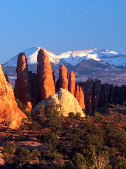
Fingers from a giant hand reaching up to tap Mount Mellenthin (12,645’) in the La Sal Mountains, viewed from Arches National Park, north of Moab, Utah. The fingers are comprised of the Slick Rock Member of the Entrada Sandstone; preserved coastal sand dunes from the Middle Jurassic (~160 Ma). Mount Mellenthin is an Oligocene (25-28 Ma) laccolithic igneous intrusion comprised mostly of hornblende-plagioclase trachyte porphyry. View to the SE.


October 20, 2022
Geoscience Community:
We greatly appreciate every Summit Sponsor and Event Sponsor that has contributed to RMAG over the last year. We could not exist without your support.
In RMAG’s 100th year we have emerged from the global pandemic to return to many of RMAG’s beloved programs, and we created new programing to meet the needs of our members and the greater geoscience community. Monthly luncheons returned to in-person, with the addition live streaming. The 2022 Golf Tournament sold out bringing over 100 golfers out for a great afternoon together. The Powder River Basin Symposium offered two days of talks and core viewing to a packed room with attendees from across the country. Members young and old celebrated RMAG’s past and future at the 100th Anniversary Party. But that’s not all, the Diversity and Inclusion Committee in conjunction with Education Outreach attended numerous community outreach events from Girl Scout Days at Dinosaur Ridge to the Juneteenth Festival, sharing our members love of the geosciences with the next generation. Short courses were held both in person and online creating educational opportunities for members in Denver and across the country.
2023 brings new opportunities for RMAG. Your sponsorship dollars will help RMAG bring to fruition the 2023 North American Helium Symposium, an exciting Field Trip season, and a dynamic list of luncheon speakers on topics ranging from the state of the industry to the Williston Basin to geothermal energy storage. These dollars will allow RMAG Members to impact the next generation at outreach events throughout the community and provide opportunities for the geoscience community to connect and build their network. We’re looking forward to seeing everyone on a more regular basis.
Your sponsorship dollars support our excellent publications including the monthly Outcrop newsletter and the quarterly Mountain Geologist journal We recognize your financial commitment with in-person signage, website and publication advertising, as well and social media posts before each online event. With a LinkedIn group of almost 3000 members, we make our sponsors visible to the geoscience community for both virtual and in person events.
Thank you to those who are already a Summit Sponsor, we look forward to your continued support in 2023. If you are not already a sponsor, please look at the many complementary benefits included with the sponsorship levels. If our annual sponsorships don't make sense for your company, or you wish to sponsor something specific, ask about our single event sponsorship opportunities. Please feel free to contact our staff with questions by email: bcrowther@rmag.org or by phone at 720-672-9898 ext. 102.
We and the staff of RMAG thank you all for your continued support and look forward to seeing you in person this year.

P: (720)672-9898 staff@rmag.org www.rmag.org
www.rmag.org
730 17th Street, B1 Denver, CO 80202


 By Sandra Labrum, Secretary slabrum@slb.com
Hi everyone! Happy New Year!
The December Board of Directors meeting took place December 16th, 2022, at 3pm in person at DERL. All board members were present. The Finance committee closed out the year with an overview of the financial situation.
Since most of the committees didn’t meet this month let’s look at the accomplishments they had this year. The Continuing Education Committee returned to in-person lunches this year to great success. Next year’s lineup features a diverse collection of talks. The Membership Committee started the RMAG Women’s Group this year as well as making some highly anticipated changes to the mentorship program. We are continuing to have coffee the first Tuesday of every month in 2023. Be sure to join us at Vibe Coffee and Wine on Jan 10th (moved due to holiday). The
Publications Committee tackled the monumental task of commemorating the 100th anniversary of RMAG in both the Outcrop and the Mountain Geologist. The issues they put together truly celebrated the history of RMAG. The Educational Outreach Committee has spent the year supporting local educators and has fostered a strong mutually beneficial relationship with Dinosaur Ridge. On the Rocks planned and put on 6 field trips this year and are already hard at work planning for the 2023 season! Finally, Diversity and Inclusion Committee was established this year and has already made a big impact at events like Denver Pride and Juneteenth.
We also said goodbye to our outgoing board members. Rob Diedrich is leaving the presidency in the hands of Ben Burke. Mike Tisher is graduating from being our Treasurer to being the President Elect.
Courtney Beck Antolik is leaving us as 1st Vice President and Lisa Wolff will be taking the role as our Vice President Elect. Mark Millard has also finished his tenure as 2nd Vice President, and we are joined by the new Vice President Elect Jason Eleson. Holly Lindsey is joining as the Treasurer Elect and Steve Crouch is taking over for Jeff May as the Counselor. Welcome to all the new board members and a sincere thank you to all the exiting board members. This year was excellent thanks to all of you! Happy New Year and looking forward to 2023.
•
•
•
• Entire greater Rocky Mountain area of North America

• West Texas and New Mexico to northern British Columbia
• Great Plains and Mid Continent region

I hope you all had a wonderful holiday season. Did anyone receive a lump of coal over the holidays? I’m sure that some of our membership are some of the few who would be excited to receive that gift now or at any time of the year. Oh the cleats, the geochemistry, and paleoenvironments!
I am humbled to be taking over as President of RMAG for 2023 after the capable leadership of Rob Diedrich as President and the entire 2022 Board of Directors. Your 2023 Board of Directors is a
capable, eager, and diverse group of energy professionals volunteering their time for the Association and ready for an exciting year of programming.
You’ll notice that I used the term energy professionals rather than oil and gas professionals. RMAG is consciously broadening its focus areas away from an exclusive focus on petroleum geoscience to a diverse mix of geoscience disciplines, including many subsurface energy and energy-related disciplines like carbon capture and underground storage, known commonly by its acronym CCUS, helium, hydrogen, and geothermal. Energy will continue to be a major focus of RMAG programming given our membership’s overriding employment in the oil and gas industry. As I have experienced firsthand in my own professional move from oil and gas into geothermal energy, there’s more overlap than one might think in those two energy forms. The focus on reservoir is still there, the energy source and its flux or migration must be considered, and the trap, seal, and preservation of it, or the medium carrying it, must also be considered. No dull moments in energy!
We are excited to bring you a great lineup of speakers at our monthly in-person lunch at Maggiano’s Restaurant in downtown Denver. Come on down, up, or over for
the event and meet some of your fellow RMAG members at the social time before the food is served and the talk begins. This month, we feature what promises to be a great talk by Trisha Curtis, CEO of Petronerds, providing an global overview of the energy industry. Plus, whether you are a season helium professional or just curious about the industry, the signature RMAG event of the first half of the year, the North American Helium Symposium, is happening at the Westminster Westin March 22nd and 23rd. Bringing together a high-quality array of upstream and midstream helium talks highlight research, exploration, and commercialization of helium at locations all over North America and all over the world, the event promises to be the premier helium event in the Denver area, and indeed in North America, for the year.
Our social event of the month is the RMAG Womens’ Coffee at Vibe Coffee Roasters on January 10th. As always, I urge to consider donating your time and/or financial resources to your RMAG if you are not already. Getting involved with a committee or helping to plan an event is a great way to meet new geoscience professionals in the region and broaden your network. Thank you to our sponsors, especially our Summit sponsors, for your ongoing support of RMAG.
(Dec 1, 2022 to Jan. 15, 2023)

(Jan. 16, 2023 to March 16, 2023)


TTHE SNAKE RIVER PLAIN OF SOUTHERN IDAHO is well known among geologists having subsided in the wake of the Yellowstone hot spot, a northeast trending track of Neogene volcanism created by the North American Plate drifting southwestward across a fixed plume of ascending magma. The plain is also known for its low relief topography, its vast Pleistocene and Holocene lava fields, and its productive fractured-rock aquifer, which sustains a host of growing communities and a strong agricultural industry. The Snake River Plain also displays stark evidence of a spectacular geologic story: the Bonneville Flood.
Largely overshadowed and understudied compared to its better known counterpart to the north (the Missoula Floods), the Bonneville Flood is a
fascinating geologic event worthy of further consideration. A plethora of fantastic erosional and depositional features inscribed on the southern Idaho landscape boldly testify of its passage. The Bonneville Flood was first described and interpreted in detail by Harold Malde (1968) in his seminal paper and further described and explained by O’Connor (1993). While the overall framework and dynamics of the flood have been established, there are many fine details and areas of interest deserving of additional scrutiny and study.
The story of the Bonneville Flood starts with Lake Bonneville, a vast, inland lake that periodically occupied much of the eastern Basin and Range province during the Pleistocene (Figure 1). At its maximum extent, the lake covered western Utah, eastern Nevada, and small portions of southern Idaho, comprising
FIGURE 1: Map showing the extent of Pleistocene Lake Bonneville at its maximum extent about 17,400 years ago.
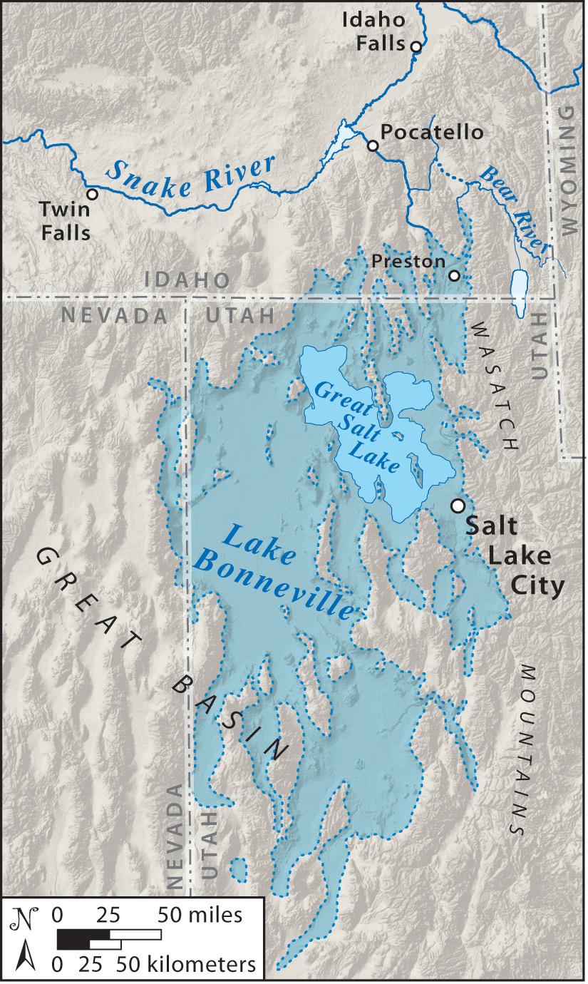
over 20,000 square miles (51,800 square km), about the size of Lake Michigan. The present Great Salt Lake of northern Utah is the latest in a long succession of lakes that have occupied the basin over at least the past 800,000 years. (Oviatt et al., 1999).
Like today’s Great Salt Lake, which is the modern remnant, Lake Bonneville resided in an enclosed basin with no outlet. As such, its extent and shorelines were largely driven by climatic oscillations. Variations in snowpack in the adjacent mountains, annual rainfall, and evaporation all played key roles in determining the size of the lake. Cool, wet periods caused
by glaciation cycles increased snowmelt and runoff into the lake, enlarging its size. In contrast, warm, dry interglacial episodes caused the water level to drop and the lake to become saline. Analysis of lake sediments and cores reveal that as much as 90% of the basin’s history was dominated by drier conditions similar to today with a saline lake in the basin (Oviatt et al., 1999). Therefore, the presence of a deep freshwater lake, coincident with glaciation events, comprises a smaller portion of the basin’s history. Lake Bonneville was the deepest and largest freshwater lake to occupy the Bonneville basin from about
30,000 to 13,000 years ago (Atwood et al., 2016). At its maximum extent, the sheer volume of water in the lake exerted a tremendous load on the crust, causing the crust to subside tens of meters in the center of the basin which hosted deeper parts of the lake (Adams and Bills, 2016).
In addition to the cool climate, one key event seems to have led to Lake Bonneville’s waters rising to unprecedented, and consequently, calamitous levels – the integration of the Bear River into the Bonneville basin. During much of the Pleistocene, the Bear River flowed northward from its headwaters in the lofty Uinta Mountains of eastern Utah, merged with the Portneuf River south of Pocatello, Idaho, and then flowed into the larger Snake River. Between 60 and 50 thousand years ago, basaltic eruptions near the town of Soda Springs, Idaho built a complex of shield volcanoes, cinder cones, and lava flows that blocked the path of the Bear River (Pederson et al., 2016). Cut off from the Snake River drainage system, the river was diverted southward into Gem Valley where it ponded briefly forming a small lake, Lake Thatcher. Subsequently, this lake overflowed southward into the Bonneville basin, incising a narrow valley, the Oneida Narrows, in the process.
The end result of this volcanic episode was the Bear River’s dramatic U-turn near Soda Springs, Idaho and its complete integration into the Bonneville basin. With its headwaters in the high, glaciated Uinta Mountains, and with the largest drainage basin (by a considerable margin) of any river feeding the lake, the Bear River became the largest tributary to Lake Bonneville. Today, the Bear River supplies more than twice the water of any other tributary to the Great Salt Lake (SWCA Environmental Consultants, 2017).
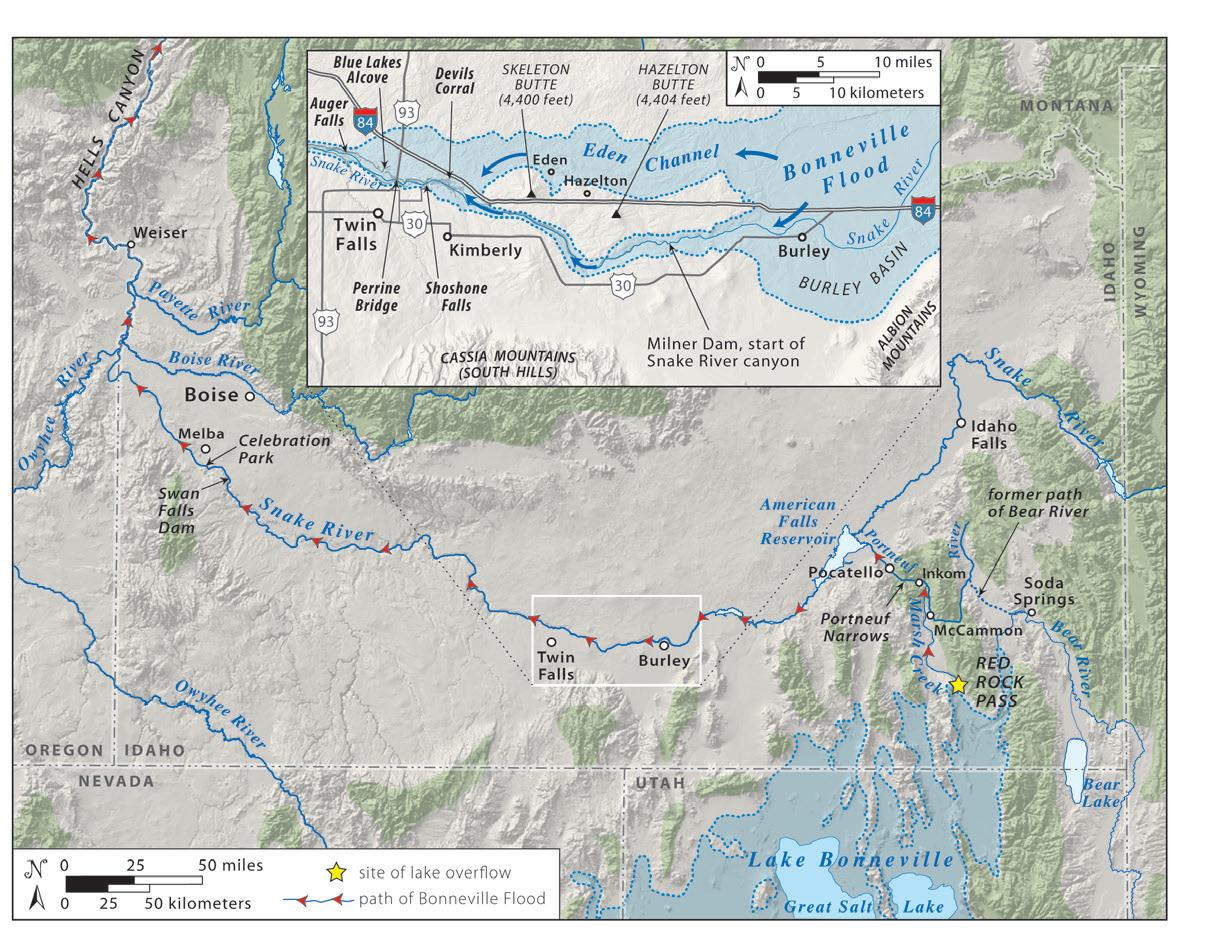
Between about 20,000 and 17,400 years ago, Lake Bonneville rose to its maximum level. The additional input of Bear River water combined with the cool, wet climate of the Last Glacial Maximum culminated in a massive freshwater lake over 1,000 feet (305 m) deep. As the lake level rose about 17,400 years ago, its waters approached the lip of its lowest drainage divide at Red Rock Pass in southeastern Idaho (Figure 2), setting the stage for the calamitous flood. Prior to the flood, this critical point impounding the lake was formed where the Marsh Creek
alluvial fan, derived from the Portneuf Range to the east, abutted a large landslide on the east side of the Bannock Range (Shroder et al., 2016).
The exact cause of the flood remains a mystery. Some research suggests that an earthquake and the resulting seismic water wave (a type of seiche) on the lake may have initiated the spillover that caused the flood (Janecke and Oaks, 2011). O’Connor (1993) postulated that groundwater seepage through the coarse alluvial sediments at Red Rock Pass, aided by the large hydraulic head from the top of the divide to the bottom of the fan, may have precipitated the flood. Alternately, the flood may have begun more innocuously as the rising lake brought the shoreline closer to, and ultimately over, the threshold of the natural divide. In any case, once water began pouring over the divide and eroding unconsolidated sediments, the Bonneville Flood had begun.
As water spilled over at the flood’s initiation point, it quickly eroded loose sediment, releasing more lake water and increasing the volume of water as well as its erosive power. Rapid and extensive erosion of the alluvial material at Red Rock Pass by the emptying lake continued until bedrock was encountered at an elevation of about 4,800 feet (1,460 m). By the end of the flood, the immense lake had dropped about 400 feet (122 m) in elevation and released a total of nearly 1,200 cubic miles (5,000 cubic km) of water (as much as the entire volume of Lake Michigan!) in a massive flood that lasted less than a year (O’Connor and Costa, 2004).
The released floodwater followed Marsh Creek northward through Marsh Valley, joining the Portneuf River near the town of McCammon. Ironically, the Portneuf River was also the likely ancestral path of the Bear River, prior to its diversion into Lake Bonneville. In Marsh Valley, the flood stripped away the overlying soil and sediment and began scouring the underlying basalt of the valley floor, a 580,000 year old lava that followed the Portneuf-Bear River drainage.
Near Inkom, the flood turned sharply westward, following the existing Portneuf River course, and entered a narrow gap cut into Proterozoic rocks known as the Portneuf Narrows. Forced through this constriction, the flood’s energy increased, causing more
erosion. Turning northwesterly as it exited Portneuf Narrows, the flood began its entry into the wide, low-relief area where Pocatello resides, and further northwest, the Snake River Plain. Here the flood spread out, slowed its velocity, and deposited huge basalt boulders as large as 12 feet (4 m) in diameter in a fan shaped deposit.
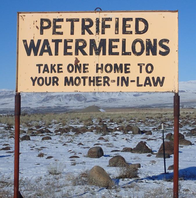
Entering the Snake River Plain just north of Pocatello, the flood entered Pleistocene American Falls Lake, where American Falls Reservoir now resides. This also marked the confluence with the Snake River, a large river system of the Pacific Northwest sourced in the Yellowstone-Grand Teton region. On its westward course across southern Idaho, through Hells Canyon and ultimately to the Columbia River, the flood’s velocity and energy increased dramatically wherever the floodwaters passed through narrow canyon sections. In these locations, the deluge plucked large blocks as big as cars from the basalt canyon walls and transported them downstream. In the roiling torrent, boulders smashed together, knocking off angular faces and corners to form rounded shapes. Where the canyon widened, the velocity slowed, allowing these large, rounded boulders to settle on the canyon floor, where they sometimes formed large longitudinal gravel bars. These conspicuous boulders form a ubiquitous and striking presence on the landscape, even inspiring a local service station to dub them “petrified watermelons” on local billboards (Figure 3) in the 1950s. Inspired by this moniker, the flood boulders became known as Melon Gravels (Malde, 1968).
FIGURE 3: Photograph of 1950s roadside sign that sparked the name “Melon Gravel” for the large boulders deposited by the Bonneville Flood. The sign still exists along US 30, east of King Hill.
The start of the scenic and narrow Snake River canyon near today’s Milner Dam and the town of Burley presented a significant obstacle to the flood. Unable to quickly and efficiently transport the massive volume of water through this tight constriction, the floodwater slowed and ponded behind this point, filling a broad basin just east and upstream. With
more water filling the basin than passing downriver through the canyon, the water in the basin accumulated and deepened. Eventually water in the basin spilled westward around the northern margin of two shield volcanoes, Hazleton and Skeleton Buttes. This new flood route formed a secondary channel or path, called the Eden Channel, for the Bonneville Flood (Figure 2 inset). Unlike the deep, narrow confines of the Snake River canyon, here the flood was ~2 to 4 miles (~3 to 6 km) wide and shallow. Despite this broad path, the volume of water, gradient, and energy were sufficient to strip away topsoil and sediment, forming an impressive scabland of scoured basalt easily visible from the air or on Google Earth. The Eden Channel lies north of, and roughly parallels, Interstate 84, passing near the small towns of Hazelton and Eden. Its path is obvious when viewed
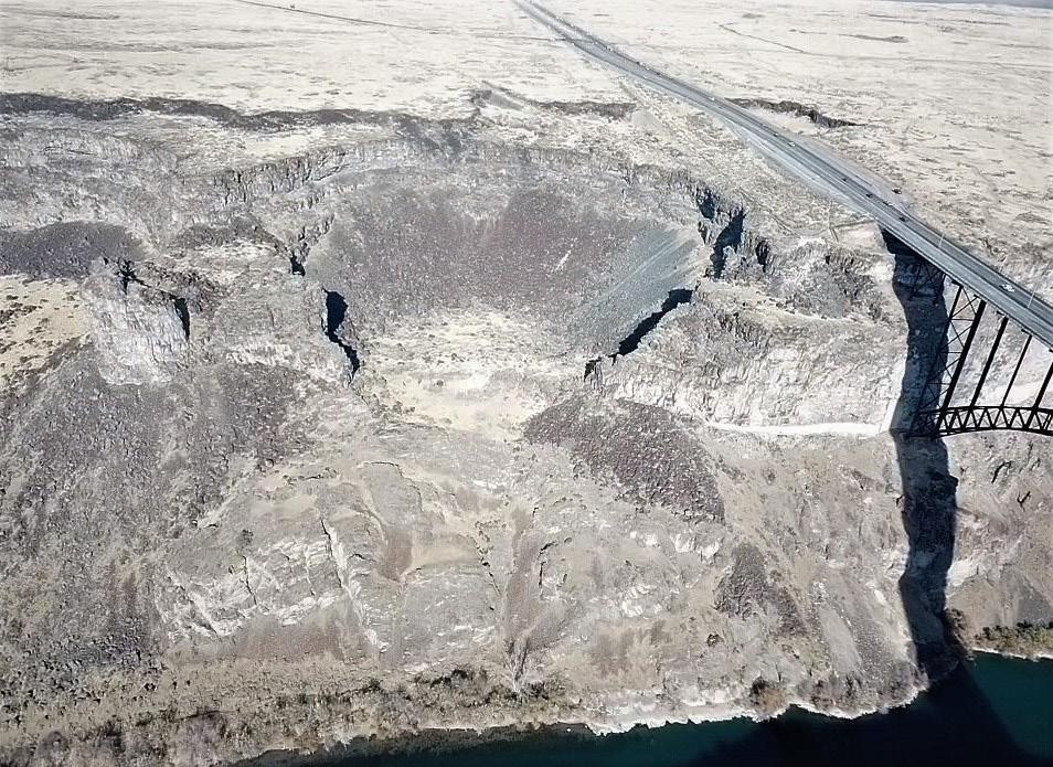
FIGURE 4: Aerial photograph to the north of large bowlshaped alcove just west of Perrine Bridge formed by pronounced erosion as the Eden Channel joined floodwaters in the Snake River. Note the stark scabland topography extending to the north. Snake River in the lower right corner.
from above as a distinct region without farm fields. The Eden Channel is notable as the only point where Bonneville floodwater diverged significantly from the path of the Snake River, following topographic lows not coincident with any watercourse. O’Connor (1993) estimated that during the flood, 60 to 70% of the total flow followed the Eden Channel.
Perhaps the most dramatic erosional landforms preserved from the Bonneville Flood lie near the city of Twin Falls where the Eden Channel rejoined the Snake River canyon. Here, the convergence of the Eden Channel with the Snake River created intensely powerful and complex hydraulics within the narrow canyon, resulting in tremendous erosion. As the Eden Channel floodwaters poured over the north rim of the Snake River Canyon, the powerful deluge plucked basalt rimrock and formed large alcoves (Figure 4), some of which eroded headward as much as a mile (1.6 km). Today these impressive erosional features can be viewed at a variety of locations such as Devils Corral, Blue Lakes Alcove, and at the Perrine Bridge.
The flood slowed in a slightly wider section of the
canyon immediately downstream of the Eden Channel’s reentry into the Snake River around Auger Falls. Here, large deposits of Melon Gravel litter the landscape and attest to the power of the flood. Most of the boulders are basalt but a few are composed of the underlying rhyolite that lines the floor of the canyon from the Perrine Bridge east to Shoshone Falls. The ~8 million-year-old rhyolite erupted as pasty lava and formed when this part of Idaho sat above the Yellowstone hot spot.
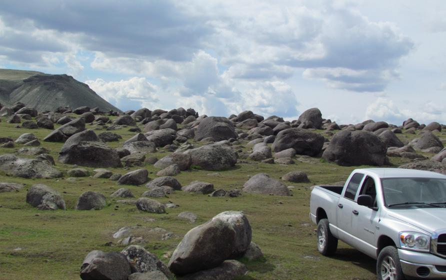
From the Twin Falls area westward, the flood raged down the path of the Snake River, eroding basalt from narrow canyon sections and depositing Melon Gravels in wider sections. One particularly impressive section lies south of Melba, where erosion through the narrow constriction at Swan Falls Dam stripped rock from the canyon’s walls and deposited it downstream to form the vast deposits of Melon Gravel at Walters Bar (Figure 5). Like most of the Melon Gravel deposited along the path of the Bonneville Flood, the surface of basalt boulders is a dark weathered varnish. Here at Walters Bar, the
FIGURE 5: View to south of Melon Gravel at Walters Bar in southwestern Idaho. Note preferential imbrication of boulders with gentle side on the left (upstream) side created by sandblasting during the flood. Truck for scale.
» CONTINUED FROM PAGE 19
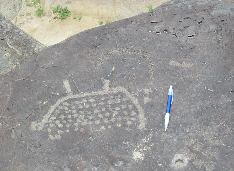
varnished surface of dozens of boulders were etched by ancient peoples to form petroglyphs (Figure 6). Set aside as Celebration Park, this is Idaho’s only archaeological park.
The constriction at Swan Falls Dam marked the last narrow canyon section in southern Idaho. Continuing northwesterly, the flood followed a markedly wider valley along the Snake River, mainly carved through soft lacustrine sediments from Miocene-Pliocene Lake Idaho, a large freshwater lake that occupied the Western Snake River Plain. Turning northward at the Oregon border, the flood inundated much of the low-lying area adjacent to the river as well as the lower reaches of major tributaries: the Boise, Payette, and Owyhee Rivers.
The floodwaters backed up again near the town of Weiser, just behind the start of a narrow, deep section that leads northward into the Hells Canyon region. Few Bonneville Flood deposits are preserved in Hells Canyon, mainly due to the steep topography and narrow canyon profile. The few wide sections, such as at Pittsburgh Landing, contain impressive boulder bars and other depositional features. Eventually, the flood reached the Lewiston area where the Snake River joins the Clearwater River, before turning west
and then joining the Columbia on its way to the Pacific Ocean.
The sheer power and magnitude of the Bonneville Flood left an indelible mark on the landscape of southern Idaho. Vast tracts of raw scabland existed where the flood’s erosive power stripped away soil and vegetation. Sheer, amphitheater-shaped alcoves were gouged into the basalt walls of the Snake River Canyon by cobbles and boulders transported by the powerful and complex hydraulics of the flood. Depositional fans and bars of large, rounded Melon Gravel filled canyon and valley floors. The Bonneville Flood undoubtedly ranks as one of the Earth’s great flood and dramatic geologic stories. While the basics of the flood’s story and geology have been established, many unanswered questions remain, awaiting further exploration and analysis.
Adams, K.D., and Bills, B.G., 2016, Isostatic rebound and palinspastic restoration of the Bonneville and Provo shorelines in the Bonneville Basin, UT, NV, and ID in Oviatt, C.G., and Shroder, J.F., eds., Lake Bonneville: a scientific update: Developments in Earth Surface Processes, v. 20, p. 145-164.
»
FIGURE 6: Petroglyphs inscribed on varnished Melon Gravel at Celebration Park, southwestern Idaho. Pencil for scale.
» CONTINUED FROM PAGE 20
Atwood, G., Wambeam, T.J., and Anderson, N.J., 2016, The present as the key to the past: paleoshoreline correlation insights from Great Salt Lake in Oviatt, C.G., and Shroder, J.F., eds., Lake Bonneville: a scientific update: Developments in Earth Surface Processes, v. 20, p. 1-27.
Janecke, S.U, and Oaks, R.Q., 2011, New insights into the outlet conditions of late Pleistocene Lake Bonneville, southeastern Idaho, USA: Geosphere, v. 7, no. 6, p. 1369-1391.
Malde, H.E., 1968, The catastrophic Late Pleistocene Bonneville Flood in the Snake River Plain, Idaho: U.S. Geological Survey Professional Paper 596, 57 p.
O’Connor, J.E., 1993, Hydrology, hydraulics, and geomorphology of the Bonneville Flood: Geological Survey of America Special Paper 274, 83 p.
O’Connor, J.E., and Costa, J.E., 2004, The world’s largest floods, past and present – their causes and magnitudes: U.S. Geological Survey Circular 1254, 13 p.
Oviatt, C.G., Thompson, R., Kaufman, D., Bright, J.,
and Forester, R.M., 1999, Reinterpretation of the Burmester Core, Bonneville Basin, Utah: Quaternary Research, v. 52, p. 180-184.
Pederson, J.L., Janecke, S.U., Reheis, M.C., Kaufman, D.S., and Oaks Jr., R.Q., 2016, The Bear River’s history and diversion: contraints, unsolved problems, and implications for the Lake Bonneville record in Oviatt, C.G., and Shroder, J.F., eds., Lake Bonneville: a scientific update: Developments in Earth Surface Processes, v. 20, p. 28-59.
Shroder, J.F., Cornwell, K., Oviatt, C.G., and Lowndes, T.C., 2016, Landslides, alluvial fans, and dam failure at Red Rock Pass in Oviatt, C.G., and Shroder, J.F., eds., Lake Bonneville: a scientific update: Developments in Earth Surface Processes, v. 20, p. 75-87.

Speaker: Trisha Curtis
Date: January 18, 2023 | 12:00 pm - 1:00 pm
As we start the new year, we’ll take a step back to examine the global overview of the state of energy. Covering topics from oil and energy, US shale oil and gas production themes and outlook. As well as addressing the realities of ongoing geopolitical impacts from China and Russia and what that means for potential recession risks.
TRISHA CURTIS is the President and CEO of PetroNerds, LLC. She founded the company in 2015 and began working full time at PetroNerds in January 2016. She was formerly the Director of Research, Upstream and Midstream, at the Energy Policy Research Foundation, Inc. (EPRINC) in Washington, DC. Since 2010, she has led extensive research efforts and major consulting projects and authored several reports on the North American upstream and midstream markets.
She was also the Manager for Strategy and Analytics at Anschutz Exploration in Denver, Colorado.
At PetroNerds, Ms. Curtis leads research and consulting services. She is a macroeconomist with an expertise in US shale markets. She is globally recognized for her knowledge of US shale and has been asked to speak and present at several forums including OPEC in Vienna, Austria, in Bahrain, and in Riyadh, Saudi Arabia, Stanford University, Chatham House, Oxford University, Denver University, and Colorado School of Mines. She is also the host of The PetroNerds Podcast.

Speaker: Timothy O. Neshiem
Date: February 1, 2023 | 12:00 pm - 1:00 pm
Madison Group reservoirs have combined to be the most productive conventional oil and gas interval of the Williston Basin. More than 32,000 vertical and horizontal Madison wells
have produced a combined 4.1 billion barrels of oil and 2.6 trillion cubic feet of natural gas (~4.6 billion barrels of oil equivalent, BOE) across both the US and Canadian portions of the Williston Basin. Early geochemical studies proposed that Madison reservoirs were sourced by the underlying Bakken Formation while numerous later studies concluded that Madison reservoirs are largely self-sourced by petroleum source beds positioned somewhere within the Madison section. However, until the past several years, minimal published information existed regarding the hypothetical Madison source beds.
Examining several dozen cores and wireline logs across
western North Dakota, two prevalent and prospective Madison source rock intervals have been identified. 1) An upper Lodgepole source rock interval that reaches up to 45 feet thick in core, TOC values of 2.7% to 5.5% (4.0% average), and Tmax values ranging from 436° to 442°C (440° average). 2) A lower Bluell source rock interval that reaches up to 14 feet thick in core, TOC values up to 5.2% (~2% average), and Tmax values of 447° to 454° (~451° average). The standard programmed pyrolysis (RockEval) data indicates both source rock interval contain primarily Type I/II oil-prone kerogen and have reached the peak to late mature stages of oil generation
TIMOTHY (TIM) NESHEIM initially earned a B.S. degree in geosciences from the Minnesota State University of Moorhead (2007), and an M.S. in geosciences from the University of Iowa (2009). Tim started working for the NDGS in 2010 as a subsurface geologist and was promoted to Head of the Subsurface Section in 2017. Most recently (2022), he began serving as Acting Core Library Manager of the Wilson M. Laird Core and Sample Library located in Grand Forks, North Dakota. His early work at the NDGS focused on the preliminary identification and evaluation of petroleum source beds within the North Dakota portion of the Williston Basin. More recently, his research focuses have shifted to core-based sedimentology and stratigraphy investigations of various formations within the Williston Basin.
production company confluenceresources.com Confluence Resources is an upstream exploration and production company confluenceresources.com


(pending vitrinite/bitumen reflectance and visual kerogen analysis data may be included in RMAG presentation). Subsurface mapping, combining core and wireline logs, demonstrate that both source rock intervals extend for at least 1-2 million acres each. Understanding the stratigraphic positioning, lateral extent, organic-richness and thermal maturity of Madison source beds may further unlock both the remaining conventional as well as the unconventional resource potential of the greater Madison petroleum system(s).

Recent exploration and development in the Midale-upper Rival play of northern Burke County of North Dakota may serve as an exploration model for re-examining Madison reservoirs for unconventional-style resources (horizontal drilling combined with multi-stage hydraulic fracturing). Initial vertical well exploration and development in northern
Burke County began in the 1950’s by targeting localized conventional reservoirs (peloidal-oolitic lime grainstone) in the upper Rival (≥10 feet thick with permeability values of 10’s of millidarcies) and secondarily targeting fractured, low-permeability (sub-millidarcy) dolomite reservoirs of the Midale. Open-hole horizontal well drilling began during the 1990’s that targeted relatively thin (<10 feet) and moderately permeable (1-5 millidarcies) upper Rival reservoir. Most recently, horizontal wells are being drilled in the upper Rival that are completed with multi-stage hydraulic-fracture stimulations which complete into the overlying Midale, and the composite reservoir section is sandwiched between two anhydrite beds. The evolution from vertical to horizontal, unconventional-style exploration and development of the Midale-upper Rival may be reproducible in other legacy Madison oil and gas fields across the Williston Basin.
Shale reservoirs are complex. This isn’t. Premier, pay-as-you-go E&P software.

With the Shale Production Optimizer, you now have access to the most popular PIPESIM workflows in one, intuitively simple, pay-as-you-go subscription service. Design your wells. Run artificial lift optimization scenarios. Identify potential bottlenecks in production. Make better decisions based on data—not guesswork.


Learn more at commerce.slb.com/production

RMAG’s Educational Outreach committee wants to create a collection of Colorado rocks that can be paired with the Colorado geological map. The committee will use these rocks as an educational tool to teach elementary, middle, and high school students about the geology of Colorado, geological processes, and Colorado mineral resources. While you are on your summer vacations to the many wonderful areas in Colorado, please consider picking up rocks for our collection. We ask you note where you collected the rocks and the formation name. ROCKD is a great app that uses your location and geological maps to “map” the formation under your feet. Keep in mind to collect rocks where it is allowed. Some examples of rocks from formations that we would love in our collection:


Marie Beise
is a teacher at Goal Academy in Pueblo, Colorado.
Fred Behnken lives in Arvada, Colorado.
Pat Cooley is a teacher at Prairie Winds Elementary in Pueblo, Colorado.
Shirley Davis is an astronomy and earth and space instructor at Windsor Charter Academy Early College High School.
Erin Flori is a teacher at GOAL High School in Pueblo, Colorado.
Mark Jacobson is a Geologist-Mineralogist with Denver Geologic Consulting, LLC in Denver, CO.

Wyatt
is a graduate student at the Colorado School of Mines and is from Spring Branch, Texas.
Joanne McGuire is an earth science teacher at Stargate Middle School in Thorton, Colorado.
Tabitha
is a teacher for District 20 at Timberview Middle School in Colorado Springs, Colorado.
lives in Montrose, Colorado.
Jess
works at Occidental Petroleum in Denver, Colorado.
Sarah Wells is a teacher for District 49 at Falcon Middle School.
JANUARY 10, 2023
RMAG Women’s Group Coffee. VIBE Coffee & Wine 1490 Curtis St. Denver, CO 80202.
JANUARY 18, 2023
RMAG January Luncheon. Speaker: Trisha Curtis. Talk: State of Energy. Maggiano’s Little Italy & Online, 12:00pm
I was born in Soldotna, Alaska, on the Kenai Peninsula. Midway through my freshman year my mother moved us to Tucson, Arizona. We then moved to West Plains, Missouri, the summer of my sophomore year where my grandparents had retired from Tesoro.
I have had passion for science and math since I was a little girl. This love and affinity have been present throughout my lifetime. After teaching high school locally for 10 years, I had a deep desire to join the oil and gas industry as it has been excellent to my family for four generations. Almost four years ago, Columbine took a chance and gave me the opportunity to combine my passion for science and desire to help, educate, and interact with many people.
In high school I was involved in many things, one of them being theatre. I was approached by the drama teacher to go to the local radio station to record a public service announcement or commercial regarding the upcoming play, Cinderella. I was fortunate to cut the commercial in one take. The Station Manager offered me a job that day as the afternoon DJ from 3-7 pm, which was awesome and a fortuitous foreshadowing.
I began my career as a secretary at a circuit board manufacturing plant in Milwaukee, WI. One
RMAG’s Diversity and Inclusion Committee is featuring a monthly Member Corner. We hope you’ll enjoy learning about the diverse community of Earth scientists and wide variety of geoscience disciplines that comprise our membership. If you would like to appear in an upcoming column, or if there is someone you would like to nominate, please contact staff@rmag.org.
of the vendors convinced me that I was a salesperson and hired me as an outside Sales Representative. I have enjoyed years of outside sales, training salespeople, and management in multiple vertical markets such as transportation, chemicals, advertising and oil and gas. Then my career changed, and I enjoyed being a local celebrity as the morning drive time host on the radio at 560 KLZ, followed by yet another career change into secondary education.
This is a tough question as I have taken many risks throughout my life. However, one of my favorites was with Don Crawford Jr. of Crawford Broadcasting, 560 KLZ. I listened to the station and knew that I could help them on-air. I must have called Don every week or two for months to no avail when I decided to send him a high heel in a shoe box with a note that read, “I am just trying to get my foot in the door.” Don called me saying something along the lines of, “I will give you five minutes”, to which I quickly replied, “Great! I only need two!”
We met in his office and immediately got along when Don asked me what experience I had on the air. Needless to say, he was amused to hear that I had two whole years of experience back in high school in rural Missouri. He then asked if I truly thought that qualified me to break into a top 50 market here in Denver. As diplomatically as I could, I replied, “Yes, sir. I’ve heard what you have on the air.” I believe that Don thought he would call what he thought was a bluff and walked me right into the studio to put me on the air. Lo and behold, the on-air mixing board was the same that I had worked with in Missouri, and I did not need to utilize his producer. Apparently, he was impressed as I was hired as the morning drive-time host.
Never settle. I have had the great fortune to do many things throughout my career and many of my positions have been very different from one another. I always have loved to work, but I realized early in my career that work is to sustain life, not monopolize your life. If you are burnt out, unhappy, or bored, change it up. Find passion in your position and if it has run its course, find joy in your work elsewhere. Life is short.
As Vice President of Sales, I am fortunate to enjoy a variety of things in my position. My favorite is meeting with and serving Columbine’s mudlogging, geosteering, and geoscience customers and future customers in Denver and Dallas/Fort Worth. I also have the privilege of motivating, managing, and shaping our dedicated sales team. Plus, I try to take every opportunity provided to speak with our Well-Site Geologists and Geosteerers to inform them of the feedback I receive on their performance and how much their dedication to excellence is not only appreciated, but also recognized. Lastly, as a member of the Executive Leadership team I am able to present ideas that hopefully make Columbine even better, e.g., new services or new processes/procedures.
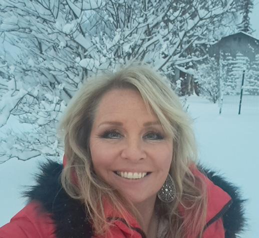
Our industry is filled with extremely competent, kind, professional, dedicated people. I truly hope to never retire!
My husband, Christopher. He means everything to me and has been my best friend for 26 years. He keeps me grounded, is the greatest sounding board I could have asked for, and is always there for me.
The Prometheus Deception by Robert Ludlum
“You miss 100% of the shots you don’t take”. -Wayne Gretzky
I have many. I love to sing, play pickleball, hunt and fish on the Kenai River, spend time with our 6 dogs and 3 llamas, work out, and spend time with family and friends.


