

OUTCROP
Newsletter of the Rocky Mountain Association of Geologists


OUTCROP
Newsletter of the Rocky Mountain Association of Geologists
730 17th Street, B1, Denver, CO 80202 • 720-672-9898
The Rocky Mountain Association of Geologists (RMAG) is a nonprofit organization whose purposes are to promote interest in geology and allied sciences and their practical application, to foster scientific research and to encourage fellowship and cooperation among its members. The Outcrop is a monthly publication of the RMAG.
2024 OFFICERS AND BOARD OF DIRECTORS RMAG STAFF
PRESIDENT Mike Tischer mtischer@gmail.com
PRESIDENT-ELECT Matt Bauer matthew.w.bauer.pg@gmail.com
1st VICE PRESIDENT Lisa Wolff lwolff@bayless-cos.com
1st VICE PRESIDENT-ELECT Nate La Fontaine nlafontaine@sm-energy.com
2nd VICE PRESIDENT Jason Eleson jason@geointegraconsulting.com
2nd VICE PRESIDENT-ELECT Ali Sloan ali@sloanmail.com
SECRETARY Drew Scherer flatirongeo@gmail.com
TREASURER
Holly Lindsey hrlindsey@bafatoy.com
TREASURER-ELECT
Astrid Makowitz astridmakowitz@gmail.com
COUNSELOR
Steve Crouch scrouch@whiteeagleexploration.com
ADVERTISING INFORMATION
Rates and sizes can be found on page 58. Advertising rates apply to either black and white or color ads. Submit color ads in RGB color to be compatible with web format. Borders are recommended for advertisements that comprise less than one half page. Digital files must be PC compatible submitted in png, jpg, tif, pdf or eps formats at a minimum of 300 dpi. If you have any questions, please call the RMAG office at 720-672-9898.
Ad copy, signed contract and payment must be received before advertising insertion. Contact the RMAG office for details.
DEADLINES: Ad submissions are the 1st of every month for the following month’s publication.
The Outcrop is a monthly publication of the Rocky Mountain Association of Geologists
DESIGN/LAYOUT: Nate Silva | n8silva.com
EXECUTIVE DIRECTOR
Bridget Crowther bcrowther@rmag.org
LEAD EDITOR
Nate LaFontaine nlafontaine@sm-energy.com
CONTRIBUTING EDITORS
Elijah Adeniyi elijahadeniyi@montana.edu
Marlee Cloos marlee.cloos@bpx.com
Danielle Robinson danielle.robinson@dvn.com
RMAG CODE OF CONDUCT
RMAG promotes, provides, and expects professional behavior in every engagement that members and non-members have with the organization and each other. This includes respectful and inclusive interactions free of harassment, intimidation, and discrimination during both online and in-person events, as well as any content delivered by invited speakers and instructors. Oral, written or electronic communications that contain offensive comments or demeaning images related to race, color, religion, sex, national origin, age, disability, or appearance are not appropriate in any venue or media. RMAG reminds members of the diversity and mission statements found on our website. Please direct any questions to staff@rmag.org


Lead Story: Desolation— Report of UGS’s float trip down the Green River through Desolation Canyon. State and industry geoscientists collaborated to investigate the Green River and Flagstaff formations in April 2024.
Advertiser Index

Ryan Gall (Utah Geological Survey) examining Flagstaff formation limestones. The Roan cliffs in the background consist of the Lower and Middle members of the Colton Formation.

MEMBERS
EVENT ATTENDEES
WEBSITE VISITORS
OUTCROP READERS
EMAIL SUBSCRIBERS
NETWORKING EVENTS
CONTINUING EDUCATION EVENTS
FIELD TRIPS
COMMUNITY CONTACTS IN 2023 YOUR SUMMIT SPONSORSHIP DOLLARS SUPPORTED: 1,200 2,000 8,000 8,500 5,000 3,500 30 15 9


Geoscience Community:
October 20, 2023
We greatly appreciate every Summit Sponsor and Event Sponsor that has contributed to RMAG over the last year. We could not exist without your support
The Rocky Mountain Association of Geologists celebrated a year of remarkable achievements, bringing together a global community of over 300 geologists for the Helium Conference for one of the first events exploring Helium production from exploration to processing. Monthly Women's Coffee, Membership Happy Hours, and thematic luncheons provided a supportive networking environment. In these gatherings, experts delved into diverse subjects, with topics that spanned from landslides to the intricate geology of the Permian Basin. RMAG also offered classes on oil and gas property valuation, enriching the skill set of members. A core workshop facilitated hands-on learning, and field trips to quarries, crater impacts and other geologic marvels ignited the spirit of exploration. Notably, the association extended its community impact through outreach at community festivals and classrooms across the Denver Metro area, emphasizing our dedication to advancing geological understanding and appreciation.
2024 brings new opportunities for RMAG Your sponsorship dollars will help RMAG bring to fruition an extensive calendar of continuing education opportunities, an exciting Field Trips season, and a dynamic list of luncheon speakers on topics ranging from the state of the industry to hydrogen and more. These dollars will allow RMAG Members impact the next generation at outreach events throughout the community and provide opportunities for the geoscience community to connect and build their network.
Your sponsorship dollars will also support our excellent publications including the monthly Outcrop newsletter and the quarterly Mountain Geologist journal We recognize your financial commitment with inperson signage, and website and publication advertising, as well as through social media before each online event. With a LinkedIn group of almost 3000 members, we make our sponsors visible to the geoscience community for both virtual and in person events
Thank you to those who are already a Summit Sponsor, we look forward to your continued support in 2024. If you are not already a sponsor, please look at the many complementary benefits included with the sponsorship levels. If our annual sponsorships don't make sense for your company, or you want to sponsor something specific, ask about our single event sponsorship opportunities. Please feel free to contact our staff with questions about sponsorship by email: bcrowther@ rmag.org or by phone at 720-672-9898 ext. 102
We and the staff of RMAG thank you all for your continued support and look forward to seeing you in 2024.
Michael Tischer
Bridget Crowther 2024 RMAG President RMAG Executive Director


12
Registration points are c u m u
and can be used for Symposiums or Short Courses. For example a
Sponsor can send 4 people to the 2023 North American Helium Symposium, and register for 4 short courses.
Registration Points are c u m u l a t i v e and can be used for any social event. For example, 1 point means 1 golfer, or 1 registration for Rockbusters. *2 points can be used for a golf hole if that makes more sense for your company.
Registration Points are cumulative for luncheons or one day field trips.
Luncheon & Field Trip Tickets
For all event tickets please contact the RMAG office at staff@rmag.org to use your spots.
RMAG 2024 SUMMIT SPONSORSHIP
All sponsor benefits event tickets follow RMAG event registration deadlines. All benefits end 12 months after registration.
RMAG 2024 ANNUAL SUMMIT SPONSOR OPPORTUNITIES
Platinum Sponsor Gold Sponsor
Silver Sponsor
Summit Sponsorship benefit term is for 12 months! Specify type of payment on signed form, and send logo and advertisements to staff@rmag.org
Company:
Company Representative:
Address:
City: State: Zip Code:
Phone: Email:
Payment Method: Credit Card ACH Check
Credit Card Information: Select Card: AMEX Mastercard VISA Discover
Name as it appears on Credit Card:
Credit Card #:
Expiration Date: Security Code:
Signature:
ACH: contact the RMAG office at staff@rmag.or for directions
Mail Checks payable to RMAG:
Rocky Mountain Association of Geologists (RMAG)
730 17th Street, B1 Denver, CO 80202
RMAG events are subject to change. Cancellation or rescheduling of events does not give the sponsor the right to refund. Summit Sponsors will receive benefits at any new events added into the RMAG schedule.
Thank you for your generous support!
P: (720)672-9898 staff@rmag.org www.rmag.org

730 17th Street, B1 Denver, CO 80202
PRESIDENT’S LETTER
By Mike Tischer
Help Us Help You!
Dear RMAG Members, Have you ever wondered who your audience is when you give a talk or present a poster? Were you ever curious who is sitting on the other side of the screen during a webinar? Did you ever check who liked your latest post on LinkedIn? Guilty as charged! I have done all of these and I bet most of you have as well. “Know your audience” is a common saying when it comes to communication. It is not just one of the most important things you can do when preparing for a talk but it is absolutely critical if you want to engage in a better, more meaningful way with any group having a common interest. Enter RMAG. The relationship between RMAG and its
members is similar. As an RMAG member, you have certain expectations when you sign up. Maybe you joined because you liked the opportunity to network with likeminded folks, or maybe you signed up because you enjoy participating in our field trips. Whatever motivated you to join or renew, there are aspects of RMAG that you appreciate enough to financially support us. (And we thank you for that very much!) There is, of course, also a flip side. There are probably things RMAG does that you don’t care much about or that you think could be improved. We are not perfect, we know. For us as an organization, it is therefore vitally important to hear from you and understand what you like and what we could do better.

O nt h eR o c k s O nt h eR o c k s
I S C H E R S P E A K F I S C H E R S P E A K S T A T E P A R K S T A T E P A R K
Join RMAG to explore the scenery and scientifically significant geology of Colorado's newest State Park, Fishers Peak. Starting with the oldest rocks we will see are the Cretaceous coal-bearing Vermejo and lower Raton formations at the park’s trailhead. The trip progresses in the Paleogene middle, upper Raton Formation, and Poison Canyon Formation to the Neogene volcanic features which form some of the more spectacular scenery in the park.


The glorious completion screen at the end of the membership survey.
Only then can we serve you as best as possible. Some of you provide this feedback during events we host, others do so via emails throughout the year. But this accounts for only a small percentage of our membership. So, in order to give everybody the opportunity to make their voice heard, RMAG prepares a membership survey every few years to be sent to our entire membership. Guess what? It’s that time again. The last RMAG membership survey was done in 2017 and reported in the October Outcrop of that same year by then President-Elect Terri Olson. The organization received over 700 submissions which represented about 40% of the membership at that time. The survey provided a plethora of great insights for the board of directors on which to act. The detailed results are also listed in that Outcrop issue. Now, over 7 years later, the geoscience and energy
landscape has changed drastically, globally as well as in the Rocky Mountain region. It is time to ask you again for your feedback and input.
You all should have received a link to the membership survey at the beginning of August. The email you received also included a pin that you can use to enter a drawing to win one of five $100 gift cards –our way of thanking you for the time spent giving your feedback. When this Outcrop is published there will still be time for you to participate and let us know what you think. Please, take a few minutes and do so if you haven’t already. We would greatly appreciate it. Why not fill it out now while you have a few minutes to spare? It won’t take long. Once you are done, you can come back here and continue exploring this month’s Outcrop. There is a lot of good stuff in this issue. Enjoy!

2024 2024 CCS WORKSHOP
October 17, 2024
Denver West Marriott
Join the Rocky Mountain Association of Geologists for a workshop on Carbon Capture and Storage (CCS) With a diverse range of insightful and comprehensive presentations covering a diverse range of technical and non-technical considerations for the permanent subsurface storage of CO2. This workshop is designed for geoscience professionals interested in CCS, offering a balanced mix of expert knowledge and practical case studies.
R E G I S T R A T I O N

PRIMACY PRIMACY


DESOLATION
Report of UGS’s float trip down the Green River through Desolation Canyon. State and industry geoscientists collaborated to investigate the Green River and Flagstaff formations in April 2024.
RILEY BRINKERHOFF1, LISA WOLFF2, MICHAEL VANDEN BERG3, RYAN GALL3
1: Duschesne River Resources 2: Robert L. Bayless Producer, LLC 3: Utah Geological Survey
ABOUT SIX
WEEKS into John Wesley Powell’s famous journey of exploration down the Green and Colorado rivers in 1869, he stopped on a long island near the mouth of the White River. The year before, he had made arrangements with a man named Johnson to plant a vegetable garden on this island so the expedition could refill their stores. Unfortunately, it being only the 6th of July, nothing was ripe, and being unattended since planting, very little was growing amongst the weeds. Someone in the party said they had heard that the leafy tops of potato plants were a tasty treat, so the hungry men boiled up the potato greens from the island and ate them for lunch. Unfortunately for Powell and his men, potato greens are not good to eat; being a member of the nightshade family, they are poisonous. The violent nausea and sickness they experienced over the next several days is reflected in the gloom and misery expressed in their journal entries and possibly explain the name that Powell gave to the canyon they soon entered: Desolation. Later, when Major Powell published his book on the expedition, he attempted to explain the name; “After dinner we pass through a region of wildest Desolation…
The walls are almost without vegetation; a few dwarf bushes are seen here and there clinging to the rocks, and cedars grow from the crevices – not like the cedars of a land refreshed with rains, great cones bedecked with spray, but ugly clumps, like war clubs beset with spines. We are minded to call this the canyon of Desolation” (Powell, 1875). Or, as the geology expedition of 2024 observed: “rocks only a lacustrine stratigrapher could love”.
Desolation Canyon is located on the northern section of the Colorado Plateau in eastern Utah (Figure 1), where the Green River winds its way from Wyoming through Utah and eventually meets the Colorado River at Confluence Point. Despite what Powell wrote about the canyon, it does have plenty of trees, ranging from firs to cottonwoods and junipers, as well as spectacular wildlife that includes bears, mountain lions, bighorn sheep, mustangs, and elk (Figure 2). But in one sense, Powell was right; the canyon is desolate in terms of people. Desolation Canyon lies at the heart of one of the most remote regions of the lower 48 states. For 84 miles and seven days, our group of geologists floated down the river and saw no other humans after launching from the Sand Wash boat ramp. No bridges cross the river, and no roads penetrate the heart of

FIGURE 1: (left)
Location map for Desolation Canyon. The Green River headwaters are located in the Wind River Mountains of Wyoming.
FIGURE 2: (below)
Desolation Canyon is a wild place full of animals. 2A: Ryan Gall and Lisa Wolff join wild mustangs for lunch. 2B: Ryan Gall and Mike Vanden Berg investigating a trail of mountain lion tracks. 2C: Mountain goats and bighorn sheep were seen on more than one occasion.


the canyon. The canyon is massive, over a mile deep from rim to water and extends up hundreds of side canyons. Once launched from the Sand Wash ramp, there is no escape except rowing the 84 miles downriver to the takeout at Swasey’s ramp near Green River (Figure 3).
Our group of hardscrabble geologic mappers, stratigraphers, and petroleum geologists were there to study the rocks the canyon cuts through on its way out of the southeastern part of the Uinta Basin. Thick Cenozoic strata form the canyon’s walls, including the Green River, Wasatch, and Flagstaff formations. Desolation Canyon has some of the best exposures of these rocks that underpin the upper third of the Colorado Plateau. Being remote, the canyon has received few geologic research expeditions in the decades since Powell’s first expedition. However, these rocks garner more interest as the Uinta Basin becomes a very busy place to drill for hydrocarbons. Oil production in the basin is at the highest levels in history. Carbon sequestration research and projects are sprouting
FIGURE 3:
Location map for Desolation Canyon showing launch ramp at Sand Wash and exit ramp at Swasey’s. Stars indicate outcrop locations, and the brown line indicates the Flagstaff Outcrop Belt. Dashed line shows cross section in Figure 3.
up, evaluating disposal of CO2 into the sedimentary fill that reaches up to six miles in thickness. The most productive natural gas wells in the basin’s history have recently been completed, and even geothermal projects are being seriously considered. The need to better understand the geology of northeastern Utah has never been greater.
Desolation Canyon offers some of the best outcrops to see the basin’s geology. The strata are mostly undeformed by faulting or folding and dip gently 3-5 degrees into the basin (Figure 4). The faulting that is present is well defined in the Sand Wash fault zone and the deformed beds of the decollement surface in the Mahogany shale (Figure 5). The canyon walls provide the inquisitive geologist with hundreds of miles of clean outcrops if they are willing to climb the cliffs. As the river cuts deeper to the south, it gradually cuts through the famous Eocene lacustrine beds of the Green River Formation and its alluvial equivalents, the Colton and Wasatch formations (the rocks change names at the Green River: the Colton Formation on


the west side of the river, Wasatch Formation on the east). Further south, the river exposes the Paleocene lacustrine beds of the Flagstaff Formation and the North Horn Formation, which lies directly on the K-T boundary. The bottom of the Cenozoic strata marks the end of Desolation Canyon, but the river then continues through the Cretaceous strata of Gray Canyon. Most river runners combine both canyons under the name Desolation. This past April, the Utah Geological
FIGURE 5: 5A - RMAG’s Lisa Wolff points out grabens in the Sand Wash fault zone, cutting the S2 sands. Movement on the fault is accommodated by slippage on an underlying decollement in the Mahogany oil shale zone. 5B - Closeup of decollement surface within slippery paper shales of the Mahogany shale.

Survey put together a 12-person research team with collaboration from industry professionals to raft down the river in four boats (Figure 6). This expedition followed a 2021 river expedition focused on the Uteland Butte and Castle Peak members of the lower Green River formation.
Our purpose was to define the top and base of the Flagstaff, sample its lithologies and get a good, measured section with an accurate gamma ray profile and
FIGURE 4: Cross section of Cenozoic strata that the Green River cuts through from the Uinta Basin horizontal oil play to the exit point of the canyon at the town of Green River.
a good photogrammetry model (Figure 7). We took advantage of our passage through other gorgeous outcrops in the canyon to study and photograph different features, including a measured section in the Castle Peak Member of the Green River Formation, but our focus was the Flagstaff.
It would be reasonable to ask why anyone would care. The Flagstaff was a major oil target in the 1970’s and 80’s, being the deepest target in the Bluebell and Altamont oil fields in the deep Uinta Basin, but since then it has received little attention and even less drilling. However, recent horizontal drilling targets deeper rocks within the Green River and Wasatch formations,
and a major operator is expected to drill the first horizontal well within the Flagstaff Formation this year. Within the Uinta horizontal oil play, the Flagstaff is typically found at depths of 10,000 to 15,000 ft, with few modern logs and no cores. The geologists working the Flagstaff have yet to even agree on the top and base of the formation, with some workers defining it rather narrowly as only being 250-300 ft thick and other workers defining the Flagstaff as being much thicker, up to 800 ft thick. The goal of our outcrop research is to define the Flagstaff at a location where its proximal facies are well exposed across a large outcrop belt, and then carefully describe and measure its

FIGURE 6: Research team from left to right: Ryan Gall (UGS), Elliot Jagneicki (UGS), Lisa Wolff (Bayless), Gabriela St. Pierre (UGS), Robert Horner (Uinta Wax), Troy Johnson (Javelin), Mike Vanden Berg (UGS), Zach Anderson (UGS), Stefan Kirby (UGS), Matthew Jones (XCL), Riley Brinkerhoff (Duchene River Resources), and Adam Hiscock (UGS). Drone photo taken at the last stop at Rattlesnake camp with the Castlegate Sandstone in the upper left and the Price River formation at river level.
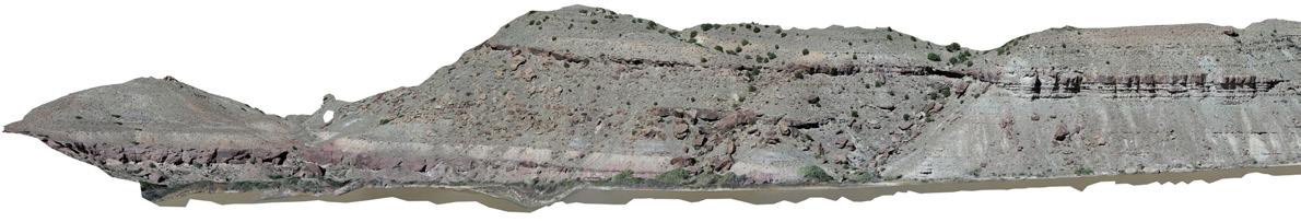
FIGURE 7: Drone based photogrammetry model of the Flagstaff formation in Three Fords camp acquired and processed by Adam Hiscock (UGS).
constituent beds. Accurately interpreting the different depositional environments that make up the formation will also help geologists to be predictive on the facies found in the deep basin (Figure 3).
The twelve of us shoved off from the ramp at Sand Wash on April 14th in four rafts loaded down with gear. Access to Desolation Canyon is strictly controlled by the BLM, with only two launches allowed per day. The UGS, being a state agency, was able to get a research permit, but we still had tight restrictions on camp locations as well as the type of samples we could collect. All boats that go down the canyon are required to bring special gear to make sure no trace is left (all waste had to be collected and carried out, all waste). The fact that Desolation Canyon is pristine is no accident and requires constant thought and effort from its visitors to remain so.
Our mix of state and industry geologists was by design. One of the primary goals of the Utah Geological Survey is to provide timely scientific information and our collaborative work delivers. The Utah Geological Survey seeks to help understand the geology of horizontal targets pursued by Uinta Basin operators to better understand the scope of the basin’s immense resources and unique lacustrine hydrocarbon system. The geologists from companies such as Uinta Wax, Javelin, XCL and Bayless were hoping to learn best practices from each other and from the UGS experts. The canyon walls in Desolation Canyon have very continuous outcrops of the Green River lacustrine system, and we were excited to see and measure the extents of different facies on the southern margin of ancient Lake Flagstaff and Lake Uinta. This trip is further evidence of how much more our science can achieve through collaboration.
The stratigraphy through Desolation starts at the upper Green River Formation and then works its way
stratigraphically downward (Figure 4). The argillaceous carbonates and shales of the upper middle and middle lower Green River aren’t strong enough to form the boulders necessary to make rapids, so the first 20 miles of the trip are through flat water. Flat water for boaters means no rapids and slow currents. To make better time down the river, we lashed all the rafts together and motored for 20 miles, spending the first night at outcrops of the Castle Peak and Carbonate Marker members of the lower Green River. At this first stop, our secondary objective was to get a full measured section of the Castle Peak Member to compare the proximal outcrop to the distal hydrocarbon targets in the basin center. In the Uinta oil play, the Castle Peak is one of the largest oil productive zones. The Carbonate Marker is becoming an important horizontal target, so we split up into two groups, one which would focus their efforts on measuring the Castle Peak, and another which would do reconnaissance on the Carbonate Marker. One of the highlights of examining the Carbonate Marker was the discovery of three fossilized turtle shells in an ostracod grainstone (Figure 8)
As we worked our way through these sections of the Green River Formation, it became clear that the southern shoreline of Lake Uinta was not a stable place. The lake repeatedly transgressed over this area, then would shrink back to the north, over and over again (Figure 9). The Green River Formation is rightly famous for its oil shales and fish fossils, but neither were to be found this far up the ancient margins of the lake. Organic-rich oil shales are deposited in quiet, relatively deep water where the water-column can be chemically stratified, leading to the preservation of organic matter at the anoxic bottom of the lake. This very marginal portion of Lake Uinta was so shallow that waves repeatedly stirred up the lake bottom,

keeping the water column from becoming stratified. The sediments being deposited were all well oxygenated, so any organic material that was deposited along the lake bottom was rapidly eaten by ancient critters living there. The lake also shrank regularly, exposing former lake bottoms to the atmosphere, where it would rapidly alter and transform into alluvial soils, full of plant roots and burrowing animals. These conditions were not conducive for the formation of oil shales.
The outcrops on the canyon walls beautifully illustrated all this. We found well oxygenated paleosols in the Castle Peak Member (Figure 10), indicating dry, alluvial conditions. Lake Uinta still existed in Castle Peak time, but it’s shores didn’t extend this far south.
Instead, the land was a flat, dry plain crossed by ephemeral rivers that scoured deeply into the alluvial soils. The Douglas Creek Member had massive sandstone deposits with bedforms indicating down-stream accreting bars in braided fluvial systems (Figure 11) The lacustrine transgression, represented by what we call the Long Point Bed, was just as well exposed, with ostracod grainstones directly overlying fluvial sandstones (Figure 12). The pelecypod and gastropod fossils in these carbonates suggested a pleasant, freshwater lake. In the basin center, this transgression is associated with a thick limestone bench with ample overlying oil shales. It’s a major drilling target there, but here it is a thin marker indicating a minor lake-level rise that soon dried up.

FIGURE 8: Three fossilized turtle shells in an ostracod grainstone in the Carbonate Marker Member of the Green River Formation. These turtle fossils are a good indicator of the environmental conditions in Lake Uinta during Carbonate Marker time, and how variable it could be. All three dying at the same time in the same place suggests that there may have been a severe drought.
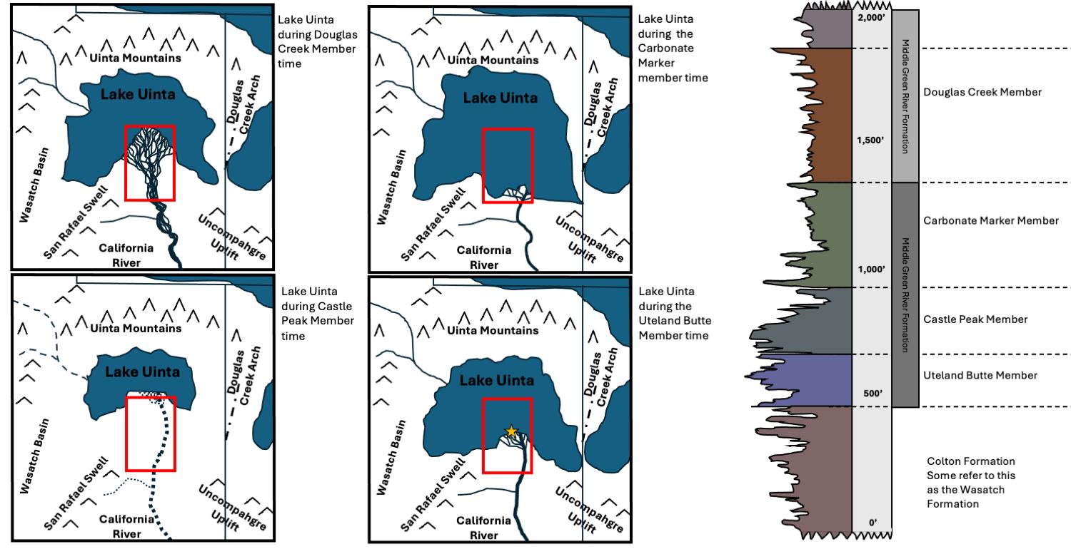
9: Stages of Lake Uinta through the Middle to Lower Green River Formation. Type log shows thicknesses and gamma ray for Douglas Creek through Uteland Butte members.
FIGURE 10: 10A- Troy Johnson of Javelin Energy stands next to a well-developed paleosol in the Castle Peak Member of the Green River Formation. It is identifiable as a paleosol by the pedogenic alteration of clays and the root casts. 10B – View of root casts from above on the same paleosol. 10CWell-drained paleosol like this suggests that the lake system is far to the north.

FIGURE

FIGURE 11: A series of stacked, down-stream accreting bars from braided fluvial systems in the Douglas Creek Member of the Green River Formation.


FIGURE 12: 12A – This carbonate grainstone marks a rapid transgression of Lake Uinta, flooding what was dry ground. Fossils (12B & 12C) show that it was fresh water with good faunal diversity (pelecypods and gastropods, especially turritella). This is the Long Point Bed, the base of the Carbonate Marker Member of the Green River Formation.
Some deposits are a great indicator for specific events in time. High-up the canyon walls in the Carbonate Marker Member, Mike Vanden Berg found a bed of microbialites (Figure 13). Modern microbialites typically occur in high salinity waters (e.g., Great Salt Lake) that are devoid of grazing invertebrates. Microbialites also indicate that water conditions were clear, far from the turbid waters near the mouth of rivers and shallow enough that sunlight can get to the lake bottom. So, we have excellent indicators of what the specific environmental was at Lake Uinta when this bed was deposited, but even more intriguing, this bed was also disrupted, with some microbial heads being ripped up and completely turned over, others flung over and buried in sand, with no laminations indicating that growth ever resumed. That storm was a bad day for these intrepid microbialites on this far southern shore.
The Uteland Butte Member is the most important target for modern horizontal drilling in the Uinta Basin. Two years ago, on our first trip down Deso, we were very keen to identify the Uteland Butte interval
and compare it to its basin center equivalents. Depositional cycles are often easier to identify at the lake’s margin than in the basin center. This is because changes in water depth are expressed as forced facies migration (transgressions or regressions of the shoreline) on the margin, whereas little difference between cycles might be noticed in the basin center. Since the basin margin has much less accommodation space, equivalent zones are much thinner in Desolation Canyon than in the basin center (Figure 14). Deeply incised and scoured beds are common, representing significant sediment bypass. But lacustrine transgressive and regressive cycles are easily apparent, with transgressions marked by lacustrine carbonates or mudstones overlying alluvial sediments and regressions marked by paleosols, mudcracks, or incised fluvial channel sets (Figure 15). Mixed coarse-grained sandstones are also common on the margin, with ostracods and quartz grains being mixed by wave action (Figure 16). Mixed lithologies like this are rare to absent in the basin center.
All too soon the time we had available to work on
FIGURE 13: 13A – Interbedded sandstones and limestones in the Carbonate Marker Member of the Green River Formation, with welldeveloped lacustrine stromatolites forming a significant portion of the limestones. Note that the stromatolite to the right has been ripped up and redeposited at an angle by a storm. 13B – Same stromatolite bed, with an individual stromatolite head being completely overturned, perhaps by the same storm. Stromatolites in Eocene lacustrine settings indicate shallow, hypersaline waters in the photic zone. The hypersaline conditions prohibit gastropods and other grazers from eating the algae that form the stromatolites.


FIGURE 14: Comparison of the Uteland Butte in Desolation Canyon at Fretwater Falls to a borehole log of the Uteland Butte in the center of the Uinta Basin. Note that the Uteland Butte is much thinner on the southern margin of the basin, less than one third as thick. Also note the change in lithology, as the unit transitions from being carbonate dominated to being a mix of fluvial and marginal lacustrine sandstones, carbonate grainstones and paleosols.

FIGURE 15: 15A - Matt Jones provides a nice scale near an overturned boulder, showing the beautiful mud cracks that lie at its base. This boulder comes from a channel that cuts into Uteland Butte Member carbonates, demonstrating that this location is at the extreme southern margin of Lake Uinta in Uteland Butte time. 15B – More mud cracks preserved in Uteland Butte ostracod grainstones.

the lower Green River members was gone. It would take two solid days of rowing downriver to travel through the intervening fluvial sediments of the Colton Formation to arrive at our main goal of the Flagstaff Formation at the Roan Cliffs. There was a series of 24 rapids that needed to be run before we got there, hard work but some geologist had to do it. e. We scheduled nearly two days at the Roan Cliffs to give ourselves plenty of time to scout the best outcrops to measure a full section of the Flagstaff. Little had been published on the Flagstaff in the Uinta Basin, and we really didn’t know what to expect. Some publications don’t even show lacustrine Flagstaff rocks in this part of the Uinta Basin (Figure 17), but from observations during our first trip, we knew that at least some Flagstaff carbonates were present. Imagine our surprise when we didn’t just find a few limestone beds, but 480 ft of Flagstaff sediments!
As so often happens in geology, the best place to get a full section of the Flagstaff was in a canyon 3 miles away from camp. We scoured the entire area looking for the best outcrops, but unfortunately
these rocks proved “bashful.” Lacustrine shales tend to weather quickly, so most of the outcrop belt had a thick mantling of landslides and regolith. But up a side canyon (Three Fords Canyon) we found exactly what we were looking for (Figure 18) and went to work, measuring section by committee of 12 geologists. We were some 19 miles farther south from where we had studied lower Green River Formation rocks (30 river miles), so we expected very marginal, shallow water lacustrine facies. Instead, we found well developed, clear water carbonates with high faunal diversity and dark lacustrine muds, intermixed with deltaic sandstones and paleosols. Evidently ancient Lake Flagstaff was a very dynamic place. We divided into groups, one carefully measuring the section with a Jacob staff and measuring stick, describing the sediments as they went (Figure 19). Another group dug into the hillside to get fresh exposures to measure gamma ray intensity with a scintillometer. A third group used drones to get a massive dataset of aerial photos with which we would build a photogrammetry model. We had limited time, but were determined to collect as much data as

FIGURE 16: 16A – Weakly pedogenically altered carbonates of the Uteland Butte Member of the Green River Formation. These carbonates are surrounded by red beds, paleosols and fluvial channels, suggesting an alluvial system that was only occasionally flooded by Lake Uinta. 16B – Many of the Uteland Butte beds consist of ostracod grainstones mixed with quartz sandstones, suggesting that wave energy mixed these grains together on beaches on the far southern shore of Lake Uinta.

FIGURE 17: 17A – Drone photo of the Flagstaff outcrop belt at the Roan Cliffs, with this location marked by a yellow star in 17B. The Flagstaff Formation is carbonate prone, with occasional sandstone channels and tabular mouth bars. 17B – Paleogeographic map of ancient Lake Flagstaff in Paleocene time. The dark outline of the ancient lake is from Reading et al, 1998. Note that this interpretation of the lake ignores the substantial Flagstaff rocks found at the Roan Cliffs. The light blue outline is a reinterpretation of Lake Flagstaff’s shorelines around the Uinta Basin.

FIGURE 18: We decided to do our measured section of the Flagstaff Formation in Three Fords Canyon. Here the top of the underlying North Horn Formation is well exposed, and a full section of the Flagstaff runs for miles along the canyon walls, allowing us to measure its lateral variability.


possible through this section.
One of the first observations made was the very fossiliferous nature of these rocks. Beyond the typical pelecypods and gastropods usually found in Tertiary lacustrine rocks, we also found a large number of vertebrate fossils, mostly of crocodilians and fish ( Figure 20). This helps us interpret the ancient lake’s water chemistry as being fresh and well circulated, a happy place for critters in the late Paleocene. What we didn’t find was also informative; there were no microbialites, probably because the lake water was too fresh. Another interesting finding was the large degree of karsting on the upper portions of some limestone beds. At repeated beds we found that the upper limestones were pitted and brecciated, indicating subaerial exposure and weathering after deposition (Figure 21). The Flagstaff Formation was deposited near the Paleocene thermal maxima, and we might expect that the hot, dry temperatures could lead to rapid evaporation and lake retreat during periods of drought. Mostly we were surprised by the thick, fossiliferous, and well-developed lacustrine system we
found. As we better understand the Flagstaff Formation in the Uinta Basin, we will have to revise our paleogeographic maps to expand Lake Flagstaff from mostly occupying the Wasatch Basin to covering a huge swath of eastern Utah south of the Uinta Mountains. We carried out hundreds of pounds of rocks to do lab tests, with plans to measure their mineralogy and organic content.
A full day of rafting remained before we would exit the canyons at the Book Cliffs. Everybody was sunburned and ready for a real shower, but conversations kept creeping back to the rocks we had studied. How did they compare to what is being found in the center of the Uinta Basin? Why was there so much karsting and brecciation in the Flagstaff limestones but not in the Green River limestones? Where were the margins of Lake Flagstaff, since what we measured was very obviously in a well-developed,

FIGURE 19: Geologists measuring the transition from a well-drained paleosol to a flooded paleosol and finally to an open-water carbonate, all within the Flagstaff Formation. This transition marks the lacustrine cycles common to the Flagstaff, where the lake would gradually transgress over the landscape, carbonates would form, then the lake would quickly retreat, leaving a dry landscape once more.


FIGURE 20: The limestones of the Flagstaff formation contained a large volume of vertebrate fossils, mostly crocodilians and fish. These fossils suggest that the lake was fresh and well circulated.
FIGURE 21: Mike Vandenberg pointing at the top surface of a freshwater limestone that contains pervasive pitting. These pits contain breccias with clasts of the same limestone, likely formed by subaerial dissolution and karstification of the limestone bed after Lake Flagstaff retreated from this area. The Late Paleocene in Utah was a very warm place, with temperatures commonly 4 degrees C hotter than today. If rains failed to come, the lake could dry up quickly.

offshore portion of the lake? What did these margins consist of? It’s often said that good science leads to good policy. That may be true, but it also leads to more questions, of which we clearly have many. I’m sure it won’t be too long before Utah’s geological community comes back to Deso to keep studying its rocks. For those seeking to learn more, the RMS-AAPG meeting is being held in Park City, UT, October 6th through October 11th, 2024, with a full day session on the
Uinta basin that will highlight more research derived from our time in Desolation Canyon. Special thanks to the Utah Geological Survey, specifically Ryan Gall, Zach Anderson, and Adam Hisock for their efforts in planning and organization, as well as the opportunity and forethought to include industry professionals through thoughtful collaboration in research that directly impacts the basin and the state of Utah.


Speaker: Stephen Drylie
Date: October 2, 2024 | 12:00 pm - 1:00 pm

Core Analysis for Emerging Energy
Presenter: Stephen Drylie
As industry interest, public support, and government subsidies for various energy transition technologies grow, numerous opportunities for investing in these new technologies have emerged. However, in order to responsibly pursue these opportunities, operators must adequately characterize the reservoirs and assess major operational risks. While the applications and risks may be new,
many of the core testing methodologies that have been perfected over decades of oil and gas exploration can be directly applied. This presentation will detail how various core tests can be leveraged in carbon storage and other applications, and when appropriate, modifications to test procedures and interpretations will be discussed.

STEPHEN DRYLIE is the engineering manager for CoreLab’s integrated studies group and director of its Carbon Capture and Storage JIP. Stephen has been working in the industry for 17 years beginning with a focus on fracturing and production/reservoir engineering. In this role, he oversees the testing program and integration of the JIP and other core analysis programs. In his current role, he assists with integrating core analysis results with petrophysical log analysis and well operations to help optimize reservoir plans and improve efficiencies. Before joining the industry, Stephen earned his degree in chemical and biomolecular engineering from the Georgia Institute of Technology.


Meet Shannon Rentz
P.G., Geologist in the Division of Minerals Evaluation, U.S. Department of the Interior

At Capitol Hill attending a Bipartisan Policy Seminar on Critical Minerals Supply Chain, April 2023.
HOW DID YOU END UP INVOLVED IN GEOSCIENCES? / WHERE DID YOU GROW UP?
I grew up in an oil & gas family in Texas. One of my grandmothers was a petroleum geologist in the Permian, and the other grandmother ran an oil well supply company in North Texas. So, I started out playing on pump jacks, and hunting fossils in highway outcrops as a child. I had a non-traditional educational background, beginning in Community College as a history major, after I got laid off from the semiconductor industry in the early 2000s. Life happened, and I stepped away from higher education for ~ a decade. When I came back to finish my undergraduate degree at Middle Tennessee State University, I wanted a field that got me outdoors regularly and had economic career prospects. I chose my graduate school based on the research and funding opportunities that were available. I had a fantastic graduate experience at Missouri State University, working on volcanology and geochemistry of ignimbrites in New Mexico.
WHO INSPIRES YOU?
RMAG’s Publications Committee is featuring a monthly Member Corner. We hope you’ll enjoy learning about the diverse community of Earth scientists and wide variety of geoscience disciplines that comprise our membership. If you would like to appear in an upcoming column, or if there is someone you would like to nominate, please contact staff@rmag.org
I am regularly inspired by the students that I meet through outreach activities and teaching. The passion and enthusiasm that is shown by young geoscientists is so cool and makes me excited for what ideas they will bring to the profession.
WHAT IS THE MOST REWARDING PART OF YOUR JOB?
The most rewarding part of my job is working for the American people. I know that what I do on a daily basis contributes a small part toward helping things
get done. Also, I learn something new every day.
WHAT
BARRIERS HAVE YOU HAD TO OVERCOME ON YOUR PATH TO BECOMING A GEOSCIENTIST?
I faced barriers related to completing my education as an adult. Figuring out how to pay for school, while maintaining a household, and a full-time job not in the geosciences was very challenging. I chose not to pursue my PhD or a career in research based on economics, whereas if I had been younger, I might have made the riskier choice.
WHAT ADVICE WOULD YOU GIVE SOMEONE ENTERING INTO THE GEOSCIENCES?
My advice would be to keep yourself open to the opportunities as they present themselves. As an undergraduate, I took a chance to participate in a research project REU funded by NSF that focused on ignimbrites in Arizona and it opened up so many other avenues to me. I had no idea if I liked geochemistry, or igneous systems, but that was how I could pay for Field Camp, so I took it. So glad I did. Don’t decide what your thing is before you try everything you can.

WHAT ARE YOUR HOBBIES OR PASSIONS OUTSIDE OF WORK?
Anything that gets me outside. I also work as a bicycle mechanic for REI and teach bike maintenance classes as a volunteer for COMBA. I love Colorado, and everything that it offers. I am a rock climber, a
skier, a cyclist, I love diving, paddling, and anything to do with water. I am also working towards my pilot’s license, so if anyone has an extra plane they don’t want, please let me know. I love food and travel and want to see so many more places in the world.
DO YOU HAVE ANY PETS?
I have one awesome adventure buddy dog named Bruce, who loves snowshoeing with me, taking epic naps, and yelling at squirrels.
In Juneau, Alaska at the Mendenhall Glacier overlook while doing fieldwork for a project with the BLM and Forest Service

IF YOU COULD VISIT ANYWHERE IN THE WORLD THAT YOU HAVE NEVER BEEN, WHERE WOULD YOU GO?
For both the skiing and the volcanoes my next two destinations are Iceland and Japan. I would also love to dive in Belize.
WHAT KIND OF MUSIC DO YOU ENJOY LISTENING TO?
I am a passionate live music fan, and I love all genres. My most recent concerts were Charlie Crockett, and Greensky Bluegrass, both at Red Rocks. For a while, I was a drummer in a Scottish Bagpipe and Drum band in Austin, Texas.
WHAT IS ONE THING YOU CAN’T LIVE WITHOUT?
Coffee. I have been accurately described as a coffee snob. I worked as a barista for several years and developed some very specific tastes.
FAVORITE QUOTE?
“Awareness of Ignorance is the Beginning of Wisdom” – attributed to Socrates.
Climbing North Table Mountain overlooking Golden, Colorado


RMAG ON THE ROCKS
Pedals and Peaks Trip Report
July 27, 2024
Trip
leaders Jordan Renner & Drew Scherer | Report by Holly Lindsey
Ten lucky geologists had the opportunity to combine two passions at the same time this summer: Mountain biking and geology. The 13-mile Sheep Creek loop showcased the Belden and Minturn formations, the Pinedale glaciation, and the London fault. »


FIGURE 1: (above left) Map showing the biking route (MTB Project), stops, and geology (Tweto, 1979). The London Fault is denoted by the black dashed line, the bike trail is in red, over a topographic base (ESRI). See the Rockd app for more detailed geology.
FIGURE 2: (above right) Screenshot from the MTB Project phone app, showing the 13 mile route and 1447’ elevation change, all above 10,000’.

Trip leaders Jordan Renner and Drew Scherer pre-rode the route so they would be able to clearly communicate the physical effort needed to complete the trip. Unlike many Front Range routes, this one started with a fun downhill…but that meant an uphill pull back to the vehicles. The MTB Project phone app is a great resource for planning as well as navigation in the backcountry (screenshot, Figure 2). We all made it back before the afternoon storms rolled in and enjoyed a refueling picnic and beverage to fortify us for the drive home.
Exposures of the early to middle Pennsylvanian Belden and Minturn Formations were mostly float, but there was plenty of it and that made it easy to quickly examine the range of lithologies in each. The Ogden Tweto (1979) Colorado geologic map does not differentiate the two formations in this area (Figure 1), but the Rockd phone app utilizes data from a higher-resolution map (Kellogg, et al, 2017). This app allows trip leaders and participants to instantly pull up the relevant data (geologic map, current
stratigraphic unit, dominant lithologies, fossils, and more) using the GPS technology in mobile devices. At Stop 1 (Figure 3) we looked at the Belden Formation (more shaly, marine and marginal marine with some sands and limestones) and at Stop 2 (Figure 4) we were in the slightly younger Minturn Formation, which is generally sandier and includes some arkoses and conglomerates.
Stop 3: Geologist-riders were able to experience the Pinedale glaciation in a whole new way, bumping over rounded cobbles and boulders as we climbed the benches gaining elevation to the northwest (Figure 5). These fairly recent deposits (as young as 12,000 years ago) formed the hummocky topography that we climbed over and rolled down for the bulk of the ride.
Stop 4: Near the head of the valley, we stopped for a snack, a drink, and a discussion about the history of mining in the South Park mining district (Figure 6). Sheep Mountain, visible from here, hosted both gold and silver deposits. Black Mountain,
FIGURE 3: Stop 1, Belden Formation.
FIGURE 4: Minturn Formation, near the Belden-Minturn contact.
ON THE ROCKS: PEDALS AND PEAKS
to the southeast of the Sheep Creek ride, was an important source of molybdenum with both open pit and underground mining. The post World War II era ushered in some uranium mining on the east side of the South Park valley near the town of Garo.
Stop 5 sparked a lively discussion about the London fault, one of the major defining features of the Mosquito Range and a key structural feature in the mining history of the area. It is a steeply dipping reverse fault associated with many ore deposits and is exposed in the London mine to the north of this area. This portion of the ride was lively as the trail races down a drainage and over the buried London fault, denoted by the black dashed line on Figure 1. We soon turned away from the fault trace and began our climb out of the drainage towards the trail intersection that led back to the cars.


FIGURE 5: One of the easier stretches of Pinedale glacial till.
ON THE ROCKS: PEDALS AND PEAKS

We had another chance to ride through the Minturn and Belden while steadily gaining back the elevation drop that we enjoyed at the beginning of the ride. If you have comments about this trip or ideas for a similar adventure, reach out to the On the Rocks committee or any RMAG board member.
SELECTED WEBLINKS AND REFERENCES
• MTB Project map of the route (free phone app is available on the Apple App Store and Google Play) https://www.mtbproject.com/trail/7007954/ sheep-creek-loop
• Tweto, Ogden, 1979, Geologic map of Colorado, U. S. Geological Survey https://ngmdb.usgs.gov/ Prodesc/proddesc_68589.htm
• Kellogg, K.S., Shroba, R.R., Ruleman, C.A., Bohannon, R.G., McIntosh, W.C., Premo, W.R., Cosca, M.A., Moscati, R.J., and Brandt, T.R. et al, 2017, Geologic map of the upper Arkansas River valley region,
FIGURE 6: Near stop 4, Sheep Mountain in the distance. Trip leaders Drew Scherer (tan shirt) and Jordan Renner (blue shirt) are in the middle of the photo facing the camera.
north-central Colorado, U. S. Geological Survey https://ngmdb.usgs.gov/Prodesc/proddesc_106559.htm
• Rockd mobile app (available on Apple App Store and Google Play) https://rockd.org/
• Mining History of the South Park Area, Colorado Historical Society, available at https://www.coloradohistory.org
• Johnson, Charles L., 1995, Molybdenum Mining in Colorado, Colorado Mining Journal
• Smith, Richard H., 1982, Uranium Mining in Colorado: A Historical Overview, University of Colorado Press

RMAG PennsylvanianPermian Field Trip Report
September 7, 2024
Field Trip Leaders: Marshall Deacon, John Webb, Steve Fryberger, Ginny Gent
Compiled by Patrick Sullivan

FIGURE 1: Trip leader Marshall Deacon pointing out meter-scale dune cross-stratification in the eolian facies of the Lyons formation in downtown Lyons (stop 1). Note the erosional bounding surface (red dashed line) and change in bed dip direction at upper right portion of the outcrop.
ON THE ROCKS: PENNSYLVANIAN-PERMIAN

FIGURE 2: Trip leader John Webb showing photos of Stygmaria, a branching tree root fossil from the Pennsylvanian-Permain period that is the potential origin of elongate to radial concretions in the Upper Fountain and Ingleside Formations (yellow arrows). Note the white/mottled reduction halo around the concretions, perhaps indicating a region of organic matter decay in largely oxidized (red) sediments. Photos taken at Hall Ranch Trailhead and US Hwy7 stops, south of Lyons.

FIGURE 3: Marshall Deacon describes cyclicity in Pennsylvanian-Permian strata exposed north of Masonville from an overlook at Ellis Ranch.

FIGURE 4: The group observes an overlook of the Fountain/Ingleside contact north of Lory State Park. Note the extensive weathering horizon (white and red mottling) due to soil development at this unconformity. Some of the vertical features at this contact are fractures filled with sediment from the Ingleside Formation intruding over a meter into the underlying Fountain Formation. (clastic dikes).

FIGURE 5: Trip leader Steve Fryberger shows the group isolated eolian dunes in the upper Fountain Formation below the contact with the Ingleside Formation (top of upper left outcrop in left photo). Eolian units in the Fountain Formation tend to be smaller and less laterally extensive than in the Ingleside and Lyons (5-20 cm beds compared to m-scale beds) due to the dunes being restricted to reworked abandoned channels. Sediment transport is mostly north-south, but individual beds show significant variability and even appeared bi-directional! (white arrows in middle picture above).
ON THE ROCKS: PENNSYLVANIAN-PERMIAN

6: The group takes a closer look at the Fountain/Ingleside contact at Lory State park. The upper Fountain has been interpreted as both fluvial and eolian at this location. Note the repeated cm-scale graded beds, which could be formed by waning wind speed or currents (middle). Meter-scale clastic dikes filled with ingleside sediment are also present at the boundary (right).

FIGURE
FIGURE 7: Steve Fryberger talks about the Lyons Formation at Lory State Park. Note the dominantly southward sediment transport direction.
ON THE ROCKS: PENNSYLVANIAN-PERMIAN


FIGURE 8: The group enjoys a final stop in the upper portion of the Lyons Formation at Lory State Park. The Lyons here shows interdune and wet dune facies – leading to a “crinkly-bedded” texture and thinner dunes.

and Pegmatites: August 31, 2024

Group photo of the field trip participants at the crest of the Dakota Hogback along Skyline Drive W of Canon City, Colorado.

Dr. Evanoff introducing the group to the exposed strata on the west side of the Fourmile Creek valley. The lowermost red rocks are the Penn-Perm Fountain Formation. The capping white layers are Lower Cretaceous Dakota Group Sandstones. The colorful rocks sandwiched between these are the Lower Jurassic Morrison Formation sandstones and shales sitting on a layer of Bell Ranch Formation, sandstones, mudstones and gypsum layers. The small topographic high between the two Dakota cliffs was the locality of the Lucas Quarries which yielded skeletal remains of Camarasaurus, Allosaurus and Apatosaurus and others. Proceeds from the Lucas Quarries were sent to Edward Drinker Cope in Philadelphia (Carpenter, 2019).
On the last day of August, 2024, RMAG hosted an On-the-Rocks (OTR) Field Trip to the vicinity of Canon City. On this beautiful summer day, field trip attendees convened in the Walmart parking lot to begin our tour. The trip geology leaders were Dr, Emmett Evanoff and John Stone. Dr. Evanoff, retired from the University of Northern Colorado, is one of the world’s leading experts on the dinosaur quarries around Canon City.
Field Trip Coordinator Rich Fantel, aided by OTR Committee Members David Schoderbek and Mike Tischer, kept the pace of the trip on schedule (mostly).
We drove N of Canon City on Garden Park Road (9), passing two of the dinosaur quarries, to the intersection with Cooper Trail. There Dr. Evanoff gave us an orientation to the local stratigraphy exposed in the steep topography across Fourmile Creek (formerly Oil Creek). The Morrison Formation here was the site of the Lucas Quarries, some of the earliest and most significant dinosaur excavations in the world (see photograph and caption above).
From the first stop, we retraced our path S back into the Garden Park Fossil Area, stopping at the famous Marsh-Felch Quarry. A great deal of information about this locality is included in the publication
by Evanoff and Carpenter (1998), with some tidbits summarized here. Hiking a short distance from the parking lot, we came face-to-face with a cliff-forming, concave-up, fluvial sandstone channel carved into gray-green mudstones with thin sandstone and limestone layers. This fluvial complex is in the upper part of the Morrison and is the site of one of the most prolific dinosaur yielding excavations anywhere, with 13 species. This quarry has produced 10 vertebrate holotypes – the “type” specimens for the species (Evanoff and Carpenter, 1998). Bones from this quarry were discovered sometime before 1877 by Sarah Felch, daughter of Marshall Felch, a local farmer. Othniel Marsh hired Marshall Felch to excavate bones and send them to his laboratory at Yale University. At least 270 crates of fossils were shipped to Marsh. At the height of dinosaur excavation, the site was populated by storage sheds for supplies and fossil bones, a forge, a furnace and an outhouse. Slope wash above sandbody 2 has obscured the walls of the quarry today (Decker, 2012).
The Marsh-Felch quarry and the Lucas Quarries were both prominent actors in the “Bone Wars”, which played out as an intense scientific rivalry between paleontologists Edward Drinker Cope of Philadelphia and Othniel Charles Marsh of Yale University.

Photo of the multistory fluvial channel incised into floodplain muds at the Marsh-Felch Quarry. There are actually 4 mapped sandstone bodies at this locality. The prominent channel is sandbody 2 and is ~4.2m thick. Sandbody 4 appears as the 2 thin layers to the left of, and above, sandbody 2. Sandbody 2 displays a prominent scour into the underlying gray-green mudstones that is directly below the quarry site. The scour is filled with large crossbeds indicating flow to the SE. The large channel sandstone is capped with smaller-scale, lower-angle lateral accretion crossbeds that preserve paleoflow directions to the W and SW (Evanoff and Carpenter, 1998).

Dr. Evanoff describing the sedimentology and the dinosaur excavation history of the MarshFelch Quarry to the group (while standing on sandbody 3). The quarry on top of the opposite bench (sandbody 2) is one of the most historically significant dinosaur localities in the world, yielding at least 10 genera. The discovered bones ranged from small isolated fragments to almost completely articulated skeletons. Genera included: Allosaurus, Apatosaurus (Brontosaurus), Brachiosaurus, Ceratosaurus, Diplodocus, Haplocanthosaurus and Stegosaurus. Bones accumulated both as a basal lag with channel gravels (lower ss) and in a deep scour in the upper point bar sands (Evanoff and Carpenter, 1998).


The “Bone Wars” were fueled by a fanatical personal animosity between these two scientists. This feud initiated one of the most productive eras of paleontological discovery in history. This time has been well-documented in numerous books of fiction, non-fiction and children’s literature. One notable example is the fictional novel written by Michael Crichton in 1974 entitled “Dragon’s Teeth.” This novel was published post-mortem in 2017 and is a rollicking good tale of dinosaur fossil intrigue set in the time of Cope and Marsh. The Bone Wars even spawned a PBS special (see the On-Line link below).
After taking in the rocks and history at the Marsh-Felch Quarry, we ate lunch at an information / picnic pullover near the river a short distance south. After lunch, we drove back into Canon City to adventure up to the top of Skyline Drive. The view of the valley on either side of the Dakota hogback comprising the spine of Skyline Drive was magical, and a bit scary. We stopped at a pull-off near well-preserved dinosaur footprints in Dakota sandstones. Before checking out the dinoturbation, we assembled for our group photo. Then, we gingerly migrated downhill (N) to the exposure of the dinosaur footprints. With our neon orange vests, we made an impression on the Skyline Drive travelers slowly creeping by in their cars. Whether they were cautious because of our safety gear, or because of the precipitous drop on either side of Skyline Drive is unknown.
Dinosaur footprints –in “worm’s eye” view (from underneath) –exposed in steeply dipping Plainview Formation sandstones of the Dakota Hogback at Skyline Drive, Canon City, CO. The circled track is ½-meter wide and has a more delicate theropod decorating it’s 10 o’clock edge (Kurtz et. al., 2001). (Photo from Google Earth).
The dinosaur trackway exposed on the underside of the steeply dipping sandstones were impressive (see photo). These tracks have been described as pentadactyl manus (5-toed forelimb “hands”) and tetradactyl pes (4-toed hindlimb or “feet”) impressions of Ankylosaurids that were traveling upward and slightly to the right in the photograph (Kurtz et. al., 2001). Ankylosaurs tracks display similar sizes between front and back feet, an indication that the track-maker was obligated to walk on all fours (Lockley, 2002). There were also many preserved impressions of plant stems (mangroves?) and sandstones with apparent root bioturbation.
After we returned to the vehicles, we carefully navigated the treacherous Skyline Drive back to Highway 50 and headed west to the vicinity of Royal Gorge.
Our next stop was a visit to the Royal Gorge Dinosaur Experience. We were led on a 45 minute guided tour through the museum by an Adventure Guide who explained the history of each skeleton in the collection. One room was populated with the dinosaurs from the Upper Jurassic excavations near Canon City. The dinosaur skeletons were flavored by reproductions of other members of the ecosystem, including pterosaurs, crocodilians, mammals and plants. An adjacent room featured skeletons from the Cretaceous Western Interior Seaway, including mosasaurs, xiphactinus and a giant sea turtle. As if these

CALL FOR ABSTRACTS
DEADLINE: OCTOBER 28, 2024
The Rocky Mountain Association of Geologists is seeking oral presentations, prospects, and exhibitors for its 2025 North American Helium & Hydrogen Conference. We plan to cover a range of topics related to Helium & Hydrogen exploration and commercialization including (but not limited to):
Helium & Hydrogen - Exploration Methods
• Elemental Properties, Source, Migration, Entrapment
• Geophysical Methods
• Geochemical Methods
• Remote Techniques – Aeromagnetics, Gravity, and soil gas geochemistry
• Associated Gases such as Carbon Dioxide (CO2)
• Analogs
Helium & Hydrogen – Temporary Storage
• The geologic condition for temporary underground storage of gases
• How to monitor long term storage
• Geologic/Geophysical modeling for underground storage integrity, seal, etc.
Non-Hydrocarbon Commercialization
• Getting from the contingent resources to reserves
• Helium or Hydrogen produced with other gases such as CO2
• Purification: Wellsite methods and success stories (or failures)
• Value Chain Considerations
Play Characterizations and Case Studies in North America:
Western Sedimentary Basin:
• Albert, Saskatchewan, Montana, Dakotas Rockies Basins:
• Paradox Basin, Green River Basin, Holbrook US Cranton Plays:
• Mid Continent Rift Zone, Anadarko Basin, DJ Basin, Kansas, Nebraska, Texas Permian Basin Eastern Basins and Plays:
• Quebec, Illinois Basin, Appalachia, Upper Michigan InternationalPlays
Markets, Regulations, Financing
• The current state of the Helium and Hydrogen markets
• Helium and Hydrogen pricing in opaque markets
• Global and regional supply and demands
• Local, State, Regional, Federal regulations and Professional Standards: updates and changes.
For More information and to submit an abstract please visit: https://www.rmag.org/He H Abstracts
Questions? Email heliumconference@rmag.org
DEADLINE: OCTOBER 28, 2024
ON THE ROCKS: CANON CITY

The group gathers for a brief introduction before going in to the Royal Gorge Dinosaur Experience.

Silhouette of the Colorado State Fossil, Stegosaurus stenops, against the backdrop of the Front Range and Royal Gorge. From the main display room at the Royal Gorge Dinosaur Experience. Stegosaurus is now available as Colorado’s license plate. It is also an invisible resident on new Colorado driver’s licenses – visible only in UV light.

skeletal remains from the Mesozoic weren’t enough to warm a geologists heart, the facility also has the Dinosaur Wild Walk, an outdoor trail populated by life-sized animatronic replicas.
Our last scheduled stop on the field trip was a massive change-up – a visit to an operating pegmatite quarry. The quarry is owned by Colorado Quarries and is a supplier of landscaping and architectural stone (see link). The property was ~ 2.5 miles south of Colorado 50 along the access road to Royal Gorge East Ridge Campground. Walking up the access road, everyone was dazzled by the sparkling boulders lining the way. Arriving at the site, the pegmatitic rock was comprised of massive pink and white alkali feldspars, huge knots of iron stained milky and rose quartz and abundant books of scintillating muscovite. We were allowed to collect from piles of material removed from outcrop faces. Mica sparkles covered the ground everywhere, including dried mud puddles. This pegmatite seemed devoid of exotic mineral phases such as topaz, spodumene or tourmaline, although everyone was looking hard. That is until Ryan Nelson discovered the “trophyof-the-day”: a beautiful blue-green hexagonal prism of beryl.
This RMAG OTR Filed Trip was a resounding success. Everyone ended the day tired and happy.
ON-LINE:
• https://www.blm.gov/visit/ garden-park-fossil-area
Display at the Royal Gorge Dinosaur Experience with a succinct explanation of the “Bone Wars.”
• https://giw.utahgeology.org/giw/index.php/GIW/ article/view/38/57
• https://files.cfc.umt.edu/cesu/NPS/ CSU/2007/07Stevens_NNL%20evaluation_%20 Decker%20Garden%20Park%20fnl%20rpt.pdf
• https://www.pbs.org/wgbh/americanexperience/ features/dinosaur-rivalry/
• https://canoncitycolorado.com/skyline-drive/
• https://dinoxp.com/
• https://www.coloradoquarries.com/
REFERENCES
Carpenter, Kenneth, 2019, History and Geology of the Cope’s Nipple Quarries in Garden Park, Colorado – Type Locality of Giant Sauropods in the Upper Jurassic Morrison Formation, Geology of the Intermontane West, Utah Geological Survey, 6:31-53. https://giw.utahgeology.org/giw/index. php/GIW/article/view/38/57
Decker, Karin, 2012, Evaluation of Proposed Expansion of the Garden Park Fossil Area National Natural Landmark, Fremont County, Colorado,
ON THE ROCKS: CANON CITY
27 pp. available on-line https://files.cfc.umt.edu/ cesu/NPS/CSU/2007/07Stevens_NNL%20evaluation_%20Decker%20Garden%20Park%20fnl%20 rpt.pdf Accessed 9/3/204. Evanoff, Emmett and Kenneith Carpenter, 1998, History, Sedimentology, and Taphonomy of Felch Quarry 1 and Associated Sandbodies, Morrison Formation, Garden Park, Colorado, Modern Geology, 22: 145-169.
Kurtz, William J., Martin G. Lockley and Donna J. Engard, 2001, Dinosaur Tracks in the Plainview Formation, Dakota Group (Cretaceous Albian) near Canon City, Colorado: A Preliminary Report on Another “Dinosaur Ridge”, The Mountain Geologist, 38(3) 155-164.
Lockley, Martin, 2002, A Guide to the Fossil Footprints of the World, University of Colorado-Denver, 124pp.

Blue-green beryl discovered by Ryan Nelson at the Colorado Quarries pegmatite locality. This was the only exotic mineral found by the group and won my admiration as the “trophy of the day.” The crystal is ~2 inches long. Photo used with permission from Bailey and Ryan Nelson.

ABOVE: Collecting site at the Colorado Quarries pegmatite mine.
MIDDLE RIGHT: The Colorado Quarries pegmatite mine was loaded with spectacular minerals. Here sparkly muscovite shreds pose with some nice pieces of graphic granite.
BOTTOM RIGHT: Completing the day, I snapped a photograph of a desiccated mud puddle coated in hardened, dry, muscovite flakes. When the shimmering mud was still wet, it was decorated by a multitude of rain drop impact craters and the tracks of modern dinosaur descendants.


WELCOME NEW RMAG MEMBERS!
Candice McMillin with TGS, from Houston, Texas
William Blankenship at the Colorado School of Mines, from Denver, Colorado
Claudio Ramos with Tracerco from Denver, Colorado
Cidney Christie with LRE Water from Denver, Colorado
Ryan North with ION Clean Energy, from Boulder, Colorado
Sophia Palumbo with Occidental Petroleum, from Golden, Colorado
Chris Cassle from Golden, Colorado
Michael Hilmes with Oasis Oil & Gas, LLC from Denver, Colorado
OCTOBER 2, 2024
RMAG Luncheon. Speaker Stephen Drylie. Talk Title: “Core Analysis for Emerging Energy.” In Person or Online. Denver Earth Resources Library, 730 17th Street, B1, Denver.
COGA. Energy Summit Conference. Denver Center for the Performing Arts.
OCTOBER 3, 2024
RMS-SEPM Geology Brewery Rendezvous. 4:30-6:30 PM. The Cidery, Denver, CO.
OCTOBER 12, 2024
RMAG On the Rocks Field Trip. Trip Leader: Karen Houck. Fishers Peak State Park, CO.
OCTOBER 17, 2024
RMAG CCS Workshop. Denver West Marriott, Golden, CO.
OCTOBER 24, 2024
RMS-SEPM Luncheon Lecture. Speaker: Jason Eleson. “CO2 Storage Potential in the DJ Basin: Screening, Reservoir Characterization and Geologic Modeling of the Lyons Sandstone.” Rock Bottom Brewery, Denver, CO.
RMAG Coffee Hour. 10:00 AM-11:00 AM. Huckleberry Roaster, Denver, CO.
OCTOBER 29, 2024
RMAG & UT Austin Alumni Happy Hour. Odell Brewing-Sloan’s Lake, Denver, CO.
IN THE PIPELINE


Expanded geologic focus:
• Entire greater Rocky Mountain area of North America
• West Texas and New Mexico to northern British Columbia
• Great Plains and Mid-Continent region

Why contribute?
• Reach a broad industry and academic audience
• Quarterly peer-reviewed journal
• Permanent archiving includes AAPG Datapages
• Quick turn-around time
• Every subdiscipline in the geosciences
Email: mgeditor@rmag.org
https://www.rmag.org/publications/the-mountain-geologist/


CALENDAR – OCTOBER 2024
RMAG CCS Workshop.
RMAG Luncheon. COGA Energy Summit Conference. RMS-SEPM Geology Brewery Rendezvous.
RMS-SEPM Luncheon Lecture. RMAG Coffee Hour.
RMAG On the Rocks Field Trip.