OUTCROP
Newsletter of the Rocky Mountain Association of Geologists


730 17th Street, B1, Denver, CO 80202 • 720-672-9898
The Rocky Mountain Association of Geologists (RMAG) is a nonprofit organization whose purposes are to promote interest in geology and allied sciences and their practical application, to foster scientific research and to encourage fellowship and cooperation among its members. The Outcrop is a monthly publication of the RMAG.
PRESIDENT Ben Burke bburke158@gmail.com
PRESIDENT-ELECT Mike Tischer mtischer@gmail.com
1st VICE PRESIDENT Ronald L. Parker parkero@gmail.com
1st VICE PRESIDENT-ELECT Lisa Wolff lwolff@bayless-cos.com
2nd VICE PRESIDENT Matt Bauer matthew.w.bauer.pg@gmail.com
2nd VICE PRESIDENT-ELECT Jason Eleson jasoneleson3@gmail.com
SECRETARY Sandra Labrum slabrum@slb.com
TREASURER
Anna Phelps aphelps@sm-energy.com
TREASURER ELECT
Holly Lindsey holly@energyfunders.com
COUNSELOR
Steve Crouch scrouch@whiteeagleexploration.com
Rates and sizes can be found on page 48. Advertising rates apply to either black and white or color ads. Submit color ads in RGB color to be compatible with web format. Borders are recommended for advertisements that comprise less than one half page. Digital files must be PC compatible submitted in png, jpg, tif, pdf or eps formats at a minimum of 300 dpi. If you have any questions, please call the RMAG office at 720-672-9898.
Ad copy, signed contract and payment must be received before advertising insertion. Contact the RMAG office for details.
DEADLINES: Ad submissions are the 1st of every month for the following month’s publication.
The Outcrop is a monthly publication of the Rocky Mountain Association of Geologists
DESIGN/LAYOUT: Nate Silva | nate@nate-silva.com
EXECUTIVE DIRECTOR Bridget Crowther bcrowther@rmag.org
OPERATIONS MANAGER Kathy Mitchell-Garton kmitchellgarton@rmag.org
LEAD EDITOR
Nate LaFontaine nlafontaine@sm-energy.com
CONTRIBUTING EDITORS
Elijah Adeniyi elijahadeniyi@montana.edu
Marlee Cloos marlee.cloos@bpx.com
Danielle Robinson danielle.robinson@dvn.com
WEDNESDAY NOON LUNCHEON RESERVATIONS
RMAG Office: 720-672-9898 Fax: 323-352-0046
staff@rmag.org or www.rmag.org












34 Colorado Fossils and Rocks: 2023 Educational Outreach, Colorado Rocks Update

38 RMAG Foundation 2022 Fundraising Results
40 RMAG Foundation 2023 Scholarship Awards
42 2022 Outcrop Awards
46 WANTED: Colorado Rocks!


October 20, 2022
Geoscience Community:
We greatly appreciate every Summit Sponsor and Event Sponsor that has contributed to RMAG over the last year. We could not exist without your support.
In RMAG’s 100th year we have emerged from the global pandemic to return to many of RMAG’s beloved programs, and we created new programing to meet the needs of our members and the greater geoscience community. Monthly luncheons returned to in-person, with the addition live streaming. The 2022 Golf Tournament sold out bringing over 100 golfers out for a great afternoon together. The Powder River Basin Symposium offered two days of talks and core viewing to a packed room with attendees from across the country. Members young and old celebrated RMAG’s past and future at the 100th Anniversary Party. But that’s not all, the Diversity and Inclusion Committee in conjunction with Education Outreach attended numerous community outreach events from Girl Scout Days at Dinosaur Ridge to the Juneteenth Festival, sharing our members love of the geosciences with the next generation. Short courses were held both in person and online creating educational opportunities for members in Denver and across the country.
2023 brings new opportunities for RMAG. Your sponsorship dollars will help RMAG bring to fruition the 2023 North American Helium Symposium, an exciting Field Trip season, and a dynamic list of luncheon speakers on topics ranging from the state of the industry to the Williston Basin to geothermal energy storage. These dollars will allow RMAG Members to impact the next generation at outreach events throughout the community and provide opportunities for the geoscience community to connect and build their network. We’re looking forward to seeing everyone on a more regular basis.
Your sponsorship dollars support our excellent publications including the monthly Outcrop newsletter and the quarterly Mountain Geologist journal We recognize your financial commitment with in-person signage, website and publication advertising, as well and social media posts before each online event. With a LinkedIn group of almost 3000 members, we make our sponsors visible to the geoscience community for both virtual and in person events.
Thank you to those who are already a Summit Sponsor, we look forward to your continued support in 2023. If you are not already a sponsor, please look at the many complementary benefits included with the sponsorship levels. If our annual sponsorships don't make sense for your company, or you wish to sponsor something specific, ask about our single event sponsorship opportunities. Please feel free to contact our staff with questions by email: bcrowther@rmag.org or by phone at 720-672-9898 ext. 102.
We and the staff of RMAG thank you all for your continued support and look forward to seeing you in person this year.
 Ben Burke
Bridget Crowther 2023 RMAG President RMAG Executive Director
months of Outcrop advertising: To receive 12 full months, company logos and ad art must be received no later than the 20th of the month in which you register.
Points are
u l
and can be used for any social event. For example, 1 point means 1 golfer, or 1 registration for Rockbusters. *2 points can be used for a golf hole if that makes more sense for your company.
all event tickets please contact the RMAG office at staff@rmag.org to use your spots.
Payment Options
All sponsor benefits event tickets follow RMAG event registration deadlines. All benefits end 12 months after registration.
Platinum Sponsor
Gold Sponsor
Silver Sponsor
Summit Sponsorship benefit term is for 12 months! Specify type of payment on signed form, and send logo and advertisements to staff@rmag.org
Company:
Company Representative:
Address:
City: State: Zip Code:
Phone: Email:
Payment Method: Credit Card ACH Check
Credit Card Information:
Name as it appears on Credit Card:
Credit Card #:
Expiration Date:
Select Card: AMEX Mastercard VISA Discover Security Code:
Signature:
ACH: contact the RMAG office at staff@rmag.org for directions.
Mail Checks payable to RMAG:
Rocky Mountain Association of Geologists (RMAG)


730 17th Street, B1
Denver, CO 80202
RMAG events are subject to change. Cancellation or rescheduling of events does not give the sponsor the right to refund. Summit Sponsors will receive benefits at any new events added into the RMAG schedule.
Thank you for your generous support!
P: (720)672-9898
staff@rmag.org
www.rmag.org
730 17th Street, B1
Denver, CO 80202
Hi everyone! Hope you had a fantastic Valentine’s Day and like me are looking forward to Spring in Colorado! Here’s hoping that you all can get the Claritin you need when allergy season strikes.
The February Board of Directors meeting took place February 15th, 2023, at 4pm online. All board members expect two were present. The Finance committee started off the meeting with an overview of the financial standing in January. January proved to be a solid start for the year, showing a strong balance sheet due to Summit Sponsorships and member renewals.
The Continuing Education Committee is continuing to host hybrid lunches with great success, albeit noisy success this month. Lily Horne will be presenting in March, Interpretation, Characterization, and Rupture Hazard Assessment of Faults in the Permian Basin. The Membership committee is continuing to revise the mentorship program to make it a more meaningful experience for the participants. We are also continuing the RMAG Women’s Group into the new year. The March coffee will be on March 7th at
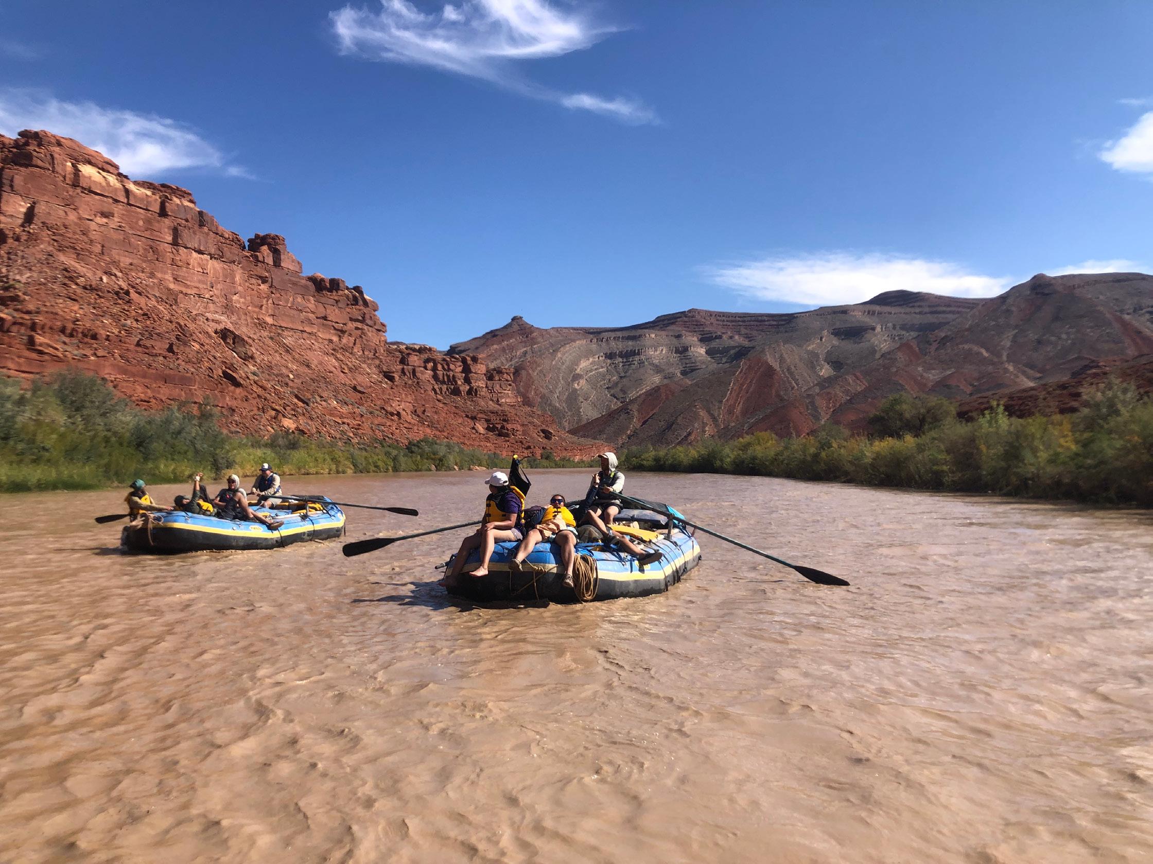
Vibe Coffee sponsored by Raptor Consulting. The Publications Committee is still hard at work making sure there is high quality content for both the Outcrop and the Mountain Geologist. They are currently looking for a new editor for the Mountain Geologist. If you are interested, please reach out. The Educational Outreach committee has a full schedule of events for this year. The next big event is Girls in STEM in March which I am personally looking forward to. On the Rocks, has started to finalize the trips for this year so keep an eye on your email for the signups. The registration for the San Juan River trip is open now! Finally, Diversity and Inclusion committee has been hard at work bringing you member corners in each Outcrop as well as cohosting the women’s group coffee. The committee is also going to continue assisting with the youth programs for the Center on Colfax.
I hope you all have a fantastic March and hope to see you at the Helium Conference later this month. Until next time!


I considered starting this column with some satire such as a headline reading, “RMAG Closing Up Shop Because of the New Fusion Energy Economy,” but I don’t want to scare the membership. We are not going anywhere. Speaking of the product of the fusion achieved late last year, this month is RMAG’s North American Helium Symposium. I’ve never prospected for helium, but I’ve watched colleagues reinvent themselves into successful prospectors for non-hydrocarbon gases like helium, hydrogen, nitrogen, and carbon dioxide, as well as fluid-borne critical minerals like lithium.

Recently, and not sarcastically, the US Department of Energy announced that energy-positive
hydrogen fusion had been achieved at Lawrence Livermore National Labs in California. This news is ground-breaking, for sure, an important first step of many in making hydrogen fusion an energy source for humanity. This is the same process that has been occurring in the Sun at the center of our solar system for billions of years. It is not, however, a near-term or medium-term source of helium. To secure that for humanity, we will need geoscientists doing what geoscientist, particularly RMAG members do best, finding the resource in the subsurface here on Earth.
If you’re an oil and gas geoscientist, the idea of prospecting for helium might immediately bring up
» CONTINUED ON PAGE 14

F i e l d T r i p s
B e h i n d t h e S c e n e s a t t h e D e n v e r M u s e u m
o f N a t u r e & S c i e n c e
M a r c h 1 1 , 2 0 2 3

9 : 0 0 a m

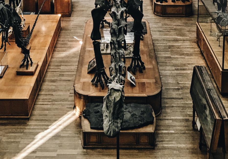
G e t a g l i m p s e b e h i n dt h e - s c e n e s a t t h e
D e n v e r M u s e u m o f N a t u r e a n d S c i e n c e w i t h D r . J a m e s
H a g a d o r n a n d G u s s i e
M a c C r a c k e n . T h i s
p o p u l a r t r i p s o l d o u t l a s t y e a r !
questions in your head such as:
• What is its wireline log signature, and on what log?
• Is seismic helpful?
• What geochemical methods are useful for helium prospecting and what labs run those methods?
• What are the sources of helium in the subsurface?
• Are petroleum systems and helium systems related or analogous?
Maybe you are interested in the midstream and business end of the budding helium economy and have questions like:
• Is there such thing as a helium refinery?
• How does midstream work for such a small-molecule, fugitive gas?
• What is the price of a unit of helium? [spoiler: it’s really high]
If you have ever asked those questions, I hope to see you at the North American Helium Symposium seeking answers and engaging with the RMAG membership present there. We also have the March monthly lunch talk by Elizabeth Horne regarding Interpretation, Characterization, and Rupture Hazard Assessment of Faults in the Permian Basin.

Geopolitically Secure and Reliable Helium Supply: Operator of Canada’s largest helium purification facility with production expected to double in 2023

Low Emissions Sourced Helium: From deep, high-pressure nitrogen fields with significantly lower emissions than hydrocarbon-based sources
Strong Customer Focus: Delivering both gaseous and liquid helium to our customers around the world
Growing Production: Spot loads of gas or liquid helium available for sale beginning in early 2023
Most Active Explorer: Over 45 wells drilled to date, with additional discoveries being advanced toward production
R o c k y M o u n t a i n A s s o c i a t i o n o f G e o l o g i s t s

5 d a y s / 4 n i g h t s o n t h e L o w e r S a n J u a n w i t h F o r t L e w i s o n t h e Wa t e r a n d G e o P r o f G a r y G i a n n i n y Y o u ’ l l e n t e r t h e G l e n C a n y o n N a t i o n a l R e c r e a t i o n a r e a a n d f l o a t t h r o u g h g o o s e n e c k s c a r v e d d e e p i n t o s a n d s t o n e e a r t h , v i s i t d r a m a t i c g e o l o g y a n d a r c h a e o l o g i c a l s i t e s , a n d e n j o y r i g o r o u s h i k i n g o p p o r t u n i t i e s .
F o r d e t a i l e d i n f o r m a t i o n : www.rmag.org

- 9 8 9 8 o r s t a f f @ r m a g . o r g
Montana has a history of large and destructive earthquakes. Major earthquakes occurred near Three Forks in 1925 (M 6.6), near Helena in 1935 (M 5.8, 6.3, and 6.0, 4 dead), west of Hebgen Lake in 1947 (M 6.2), and most importantly, at Hebgen Lake in 1959 (M 7.3 with 5 aftershocks M 6.0–6.5, 29 dead). Written accounts of all these earthquakes documented the occurrence of energetic aftershock sequences. However, all these earthquakes occurred before a systematic network of seismograph stations operated in Montana, and only a few of the largest aftershocks are documented in earthquake catalogs. The absence of local seismographic recording makes even the locations, focal depths, and focal mechanisms of these important historic earthquakes a matter of ongoing discussion and debate (Stickney, 2022). During the four decades since the Montana Regional Seismograph network began routinely recording and cataloging seismicity in 1982, only two earthquakes with magnitudes in the 5.6 to 5.8 range have occurred in western Montana. The detailed seismic monitoring coverage now available has provided new insights into the behavior of aftershock sequences and how they relate to moderate-magnitude earthquakes.
The Intermountain Seismic Belt (ISB) is a 1400-km-long zone of shallow seismicity that arcs from northwestern Montana to southern Nevada (Figure 1), passing through Yellowstone National Park and along the Wasatch Range in central Utah (Smith and Arabasz, 1991). An arm or branch of the ISB—known as the Centennial Tectonic Belt (CTB; Stickney and Bartholomew, 1987)—extends westward from Yellowstone into west-central Idaho, along the northern margin of the Snake River Plain. The ISB is marked by a 100-km-wide zone of diffuse, shallow seismicity with hypocenters typically ranging from 3 to 16 km below the surface. Earthquake swarms and mainshock–aftershock sequences are common within the ISB, but surface-rupturing earthquakes have occurred only three times historically (M 6.6, Hansel Valley, UT in 1934; M 7.3, Hebgen Lake, MT in 1959; and M 6.9, Borah Peak, ID in 1983). There are numerous late Quaternary faults within the ISB and CTB, but except for the very largest earthquakes and a few other notable exceptions, Montana seismicity does not correlate with mapped Quaternary faults (Stickney, 2007). Rather, routine seismicity tends to occur in the footwall blocks, or off either end of mapped Quaternary faults. The three » CONTINUED ON PAGE 18

» CONTINUED FROM PAGE 16
surface-rupturing historic earthquakes, together with more recent instrumentally determined focal mechanisms, indicate that extensional tectonic forces drive ISB seismicity. To the north of Yellowstone and along the western CTB, extension is directed NE–SW, while south of Yellowstone, extension is directed nearly E–W. The extension directions are more complicated near the Yellowstone Caldera and are oriented NNE in the Hebgen Lake region. Most ISB earthquakes involve normal or normal-oblique faulting. However, earthquake focal mechanisms from
west-central and northwest Montana indicate that strike-slip faulting is common. In contrast to the high levels of seismicity observed along both margins of the Snake River Plain, the SRP itself is remarkably aseismic (Figure 2)

No earthquakes over magnitude 6.0 have occurred in Montana since the aftershock sequence of the 1959 M 7.3 Hebgen Lake earthquake, over six decades ago. The Montana Bureau of Mines and Geology (MBMG) began routinely monitoring, locating, and reporting earthquakes in 1982. Thus, a major
» CONTINUED ON PAGE 19
Montana earthquake and its aftershock sequence has yet to be recorded by the permanent regional seismograph network. However, two moderate-magnitude earthquakes have occurred within the Montana Regional Seismograph Network. The aftershock sequences of the M 5.6 Dillon earthquake in 2005 and the M 5.8 Lincoln earthquake in 2017 (Figure 2) have provided some unexpected insights into shallow-focus earthquakes along the northern ISB.

The July 26, 2005 Dillon earthquake occurred 15 km north of Dillon within a region of previously low seismicity. The M 5.6 Dillon earthquake caused damage to some masonry structures (Figure 3) and chimneys in Dillon. Unfortunately, the Dillon earthquake occurred at the western edge of the seismograph network and there were no seismograph stations operating within 45 km of the epicenter. The
MBMG coordinated with the U.S. Geological Survey to install a new seismograph station near the epicenter about 2 weeks after the earthquake, thus filling a monitoring coverage gap in the network. Over the next 5 years, the MBMG located 1,971 aftershocks ranging from less than magnitude 0.2 to 4.2. Fifty-two aftershocks had magnitudes of 3.0 or larger and 61 percent of the aftershocks occurred during the first year after the mainshock. The Dillon aftershocks form an elliptical cluster with a N–S dimension of 8 km and 4 km in the E–W dimension (Figure 4). The smaller patch of epicenters east of the main aftershock cluster followed a magnitude 3.9 earthquake 6 months after the mainshock, likely on a nearby but different fault than the mainshock. This small aftershock sequence within a larger aftershock sequence illustrates some of the complexity inherent in such earthquake sequences. The Dillon mainshock occurred at a depth of 10.9 km below the surface
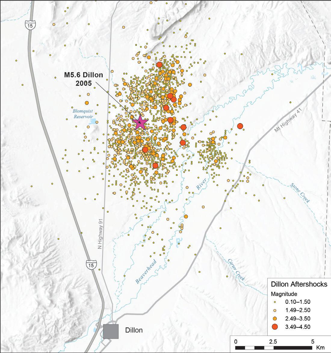
FIGURE 5: P–T axes from 91 Dillon aftershocks. (A) Contoured T-axis orientations with average extension direction of N55E labeled. The rose diagram illustrates the azimuthal T-axis distribution. (B) Contoured P-axis orientation. Squares labeled 1, 2, and 3 are the orientations of sigma 1, 2, and 3, respectively, calculated from this set of P-axis orientations.

» CONTINUED FROM PAGE 19
along a north-trending, east-dipping oblique-normal fault that apparently lacks any surface expression. Aftershock fault plane solutions indicate primarily oblique-normal faulting with some pure strike-slip mechanisms and even a few oblique-reverse mechanisms. P-axis orientations (sigma 1, the maximum principal stress; Figure 5a) form a linear belt from NW, through vertical, to SE, with a slight concentration plunging about 80° at about N35°W, reflecting the variety of focal mechanisms. The common denominator for virtually all aftershock focal mechanisms is a NE–SW-oriented T-axis (sigma 3, the least principal stress; Figure 5b).
Viewed in cross section, the majority of aftershock hypocenters formed a V-shaped cloud lying above the inferred mainshock fault plane. The orientation and dimensions of the fault plane that ruptured during the mainshock were estimated from the focal mechanism and the distribution of aftershocks that occurred during the first 24 hours. The moment
magnitude and fault plane dimensions of 5.5 km by 3.25 km were used to estimate an average slip displacement of 56 cm. All of these parameters served as input for the software package Coulomb 3.3 (Toda and others, 2011), which calculates static stress changes in the surrounding region resulting from the mainshock fault slip. A cross-section perpendicular to the fault plane (Figure 6) shows the change in dilatational stress resulting from the mainshock. Remarkably, the vast majority of the aftershock hypocenters occurred within the quadrant above the fault plane where dilatational stress increased. Within this quadrant, the normal stress on preexisting small faults and fractures was reduced, triggering aftershocks. The corresponding quadrant below the fault plane is largely aseismic, likely because it is predominately below the brittle–ductile boundary at about 16 km depth. This visualization of stress change provides a plausible explanation for the V-shaped cloud of aftershocks lying above the fault plane instead
» CONTINUED ON PAGE 22
of tracing out the fault plane that slipped during the mainshock.
The July 6, 2017 Lincoln earthquake occurred 13 km southeast of the small town of Lincoln, MT and was felt throughout western Montana and adjacent parts of surrounding states and provinces. Only minor damage and a brief power outage at Lincoln were reported following the M 5.8 earthquake, likely due to its remote location from larger population centers like Helena. The Lincoln earthquake occurred along the main axis of the ISB in a region of abundant previous seismicity and within the footprint of the Montana Regional Seismic Network. The three closest surrounding seismograph stations
were 20 to 40 km from the mainshock epicenter, so the U.S. Geological Survey deployed three temporary stations near the epicenter to improve aftershock hypocenter location accuracy. Several weeks later, the University of Montana Geosciences Department deployed three additional stations to improve focal sphere coverage. The U.S. Geological Survey removed their stations in October, but the University of Montana stations ran through the winter and they deployed seven additional stations the following summer. All the temporary stations supplementing the permanent network provided unprecedented seismographic monitoring coverage for the vigorous aftershock sequence. During the 5 years following the Lincoln earthquake, the MBMG located 4,473 aftershocks (Figure 7) ranging in magnitude from 0.0 to 5.1. Fifty-eight aftershocks had a magnitude of 3.0
» CONTINUED ON PAGE 24

FIGURE 7: Epicenters of the magnitude 5.8, July 6, 2017 Lincoln earthquake (largest star), two magnitude 5 aftershocks (smaller stars), and 4,734 aftershocks that occurred during the next 5 years. The magnitude 5 aftershock lying southwest of the principal aftershock cluster occurred 5 minutes after the mainshock when significant ground motion was still in progress; it is likely mislocated. The smaller epicenter clusters south of Lincoln represent bookshelf faults that Smith and others (2021) identified.
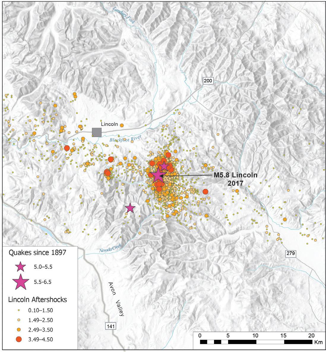
or larger and 76 percent of the aftershocks occurred during the first year after the mainshock.
The focal mechanism for the Lincoln earthquake indicated strikeslip faulting, either right-lateral on a WNW-trending fault, or left-lateral on a NNE-trending fault. This region of the ISB is transected by the Lewis and Clark Zone (LCZ), a structurally complex system of long-lived, WNW-trending faults and folds extending 400 km from the Helena region in west-central Montana to northern Idaho. Most of the dozen major LCZ faults do not have documented later Quaternary offset, although a couple well to the east and west of Lincoln do. Therefore, when the Lincoln mainshock occurred within the LCZ and had a WNW-trending nodal plane, it was reasonable to assume that this earthquake resulted from dextral slip on a WNW-trending LCZ fault. However, the aftershocks tell a different story. After just a few days, the aftershock epicenters defined an elliptical cluster about 9 km long and 5 km wide. The long axis trends north. Precise relocations of these aftershocks (Smith and others, 2021) show the aftershock hypocenters in this cluster define a north-trending, steeply east-dipping plane from 10 to 20 km deep (Figure 8). Precise aftershock locations together with the mainshock and many aftershock focal mechanisms indicate that the Lincoln earthquake occurred on a N-trending sinistral fault that lacks surface expression. Another interesting aspect of the Lincoln aftershocks sequence was the occurrence of several isolated clusters of aftershocks that occurred up to 15 km west of the mainshock epicenter.
» CONTINUED ON PAGE 25
first 16 months of the aftershock sequence,
Map view of aftershock epicenter clusters. Red star is mainshock epicenter and the longest blue line represents the strike of the mainshock fault plane determined from the moment tensor solution. Shorter blue lines represent faults inferred from hypocenter trends and fault plane solutions. (B) West to east cross-section (looking north) of aftershock hypocenter clusters. Red star is mainshock hypocenter and the longest blue line represents the dip of the mainshock fault plane determined from the moment tensor solution. Shorter blue lines represent faults inferred from hypocenter trends and fault plane solutions.

The precise aftershock hypocenter relocations (Smith and others, 2021) showed that these clusters formed short, northerly trending, linear zones (Figure 8). Aftershock focal mechanisms indicated strike-slip faulting similar to the mainshock mechanism. Taken together, these observations illuminated a west-trending zone of individual, north-trending sinistral faults activated by the Lincoln mainshock. The most reasonable explanation for this pattern of isolated aftershock clusters is a zone of bookshelf faulting (Smith and others, 2021). Dextral shear across the LCZ is resolved as sinistral slip on a series of subparallel, north-trending faults. Bookshelf faulting implies that rigid blocks within the LCZ are rotating clockwise under the influence of dextral shear, with their N-trending margins (faults) slipping past each other in a sinistral sense. If this behavior is typical of this portion of the ISB, perhaps it helps explain the lack of recognized late Quaternary offset on the major WNW-trending LCZ faults.
Aftershock sequences have revealed new information about the behavior and characteristics of moderate-magnitude earthquakes in the northern ISB. It is unlikely that this information would have come to light without data from a modern seismic monitoring network. We look forward to learning new information in the future as opportunities present themselves.
Smith, E.M., Martins, H.R., and Stickney, M.C., 2021, Microseismic Evidence for Bookshelf Faulting in Western Montana: Seismological Research Letters, v. 92, p. 802–809, https://doi. org/10.1785/0220200321
Smith, R.B., and Arabasz, W.J., 1991, Seismicity of the Intermountain Seismic Belt, in Slemmons, D.B., Engdahl, E.R., Zoback, M.D., and Blackwell, D.D., eds., Neotectonics of North America: Boulder, Colo., Geological
Society of America, Decade Map, v. 1.
Stickney, M.C., 2007, Historic earthquakes and seismicity in southwestern Montana: Northwest Geology, v. 36, p. 167–186.
Stickney, M.C., 2022, Earthquakes and seismographic monitoring in Montana, in Metesh, J.J., and Gammons, C.H., eds., Geology of Montana—Special Topics: Montana Bureau of Mines and Geology Special Publication 122, v. 2, 50 p., available at https:// mbmg.mtech.edu/pdf/geologyvolume/StickneyEarthquakesFinal.pdf
Stickney, M.C., and Bartholomew, M.J., 1987, Seismicity and late Quaternary faulting of the Northern Basin and Range Province, Montana and Idaho: Bulletin of the Seismological Society of America, v. 77, p. 1602–1625.
Toda, S., Stein, R.S., V. Sevilgen and Lin, J., 2011, Coulomb 3.3 Graphic-Rich Deformation and Stress-Change Software for Earthquake, Tectonic, and Volcano Research and Teaching—User Guide: U.S. Geological Survey Open-File Report 2011-1060, 63 p.
A premier exploration and production company focused on the acquisition, exploration, development, exploitation and trading of conventional and unconventional oil, natural gas, and helium resources on a global perspective
Operating merging unconventional oil and gas play in Texas, and North America, and undertaking world-class helium gas field
Multiple international trade channels in Specialty Gases and LNG
S&P/ASX 300 Index since March, 2019
Headquartered in Houston, TX and having offices in Perth, Australia and Beijing, China
http://www.heliosenergyltd.com/

HYBRID
Speaker: Elizabeth Horne
Date: March 1, 2023 | 12:00 pm - 1:00 pm

Presenter: Elizabeth Horne
Co-Authors: Peter Hennings, Katie Smye, Amanda Calle, and Alan Morris Bureau of Economic Geology, Jackson School of Geosciences, the University of Texas at Austin.
The Permian Basin of West Texas and Southeast New Mexico is the most productive petroleum province in the world, with over 35,000 horizontal wells drilled in recent years. The region is experiencing elevated levels of seismicity alongside petroleum development, with over 680 earthquakes of ML≥3.0 since 2017 and 11 earthquakes of ML≥4.5 since 2021. Many of these events have been linked to oilfield operations, including wastewater disposal at multiple subsurface levels and, to a lesser degree, hydraulic fracturing. However, linking earthquakes to hazardous faults has been challenging due to limitations of existing fault maps.
Here we present a regional interpretation, characterization, and kinematic synthesis for basement-rooted faults mapped across
the Permian Basin to understand the causal factors of earthquakes in the region and assess the evolving hazard. Our fault map includes over 11,000 km (~8,000 mi) of basement-rooted fault length mapped across the Permian Basin. Faults are characterized according to morphology (length, orientation, structural style), as well as mapping confidence (high and moderate) to reflect variability in the quality, density, and aerial extent of data. We also perform fault rupture hazard analysis in the form of fault slip potential (FSP, expressed as the pore-pressure required for fault criticality, Ppcrit), and compare the results with multiple earthquake catalogs to better understand fault sensitivity, determine which faults have been seismogenic, and understand the uncertainties of these assessments.
ELIZABETH HORNE is a Research Scientist Associate III at The University of Texas Bureau of Economic Geology where she is the structural interpretation specialist for the TexNet Seismic Monitoring and Center for Integrated Seismicity Research (CISR) consortium. She is also the lead Principal Investigator for the Regional Induced Seismicity Collaborative (RISC). Elizabeth received a B.S. in Geology at Utah State University in 2013 and a M.S. in Geology at Colorado School of Mines in 2016. Her research interests include integrating field and subsurface datasets to generate three-dimensional models that are used to better understand the kinematic evolution of various structural systems, as well as assess seismic hazards, both naturally occurring and induced. Elizabeth is a member of several professional societies, including: AAPG, AGU, GSA, and RMAG.



Speaker: Stephen Slaughter
Date: April 5, 2023 | 12:00 pm - 1:00 pm
Landslides occur in all 50 states and territories and landslide loss in the US is estimated in the billions of dollars and cause multiple deaths annually. Landslides can happen with no notice and can move over a period of seconds, hours, days, weeks, or longer. They can damage or destroy homes, infrastructure, transportation networks, and utilities. Despite the scientific community’s thorough understanding of landslides processes and the hazards they pose to society, there remain numerous challenges to reducing annual loss and increasing public safety from landslides. These
challenges include identifying who and what is vulnerable to landslides; understating how land use, land management, and development influence risk; and how historical and current policies create inequities and vulnerabilities from landslides. This presentation will discuss those challenges along with other issues landslides pose to governments and homeowners. Significant historic landslides and their societal impacts will also be discussed along with reasons why future homeowners should always consider landslide hazards when choosing to live near or on a slope.
STEPHEN SLAUGHTER has worked in landslide hazards for nearly 20 years, focusing primarily on landslide inventories, susceptibility and hazard analysis, outreach, and emergency response. His current role is the Associate Program Coordinator for Landslide Hazards at the USGS, which helps direct the Landslide Hazards Program. He also coordinates landslide technical response for domestic and international landslide disasters. Prior to the USGS, Stephen’s career varied from consulting forest land managers on harvest-related landslides, working on emergency teams to assess post-wildfire debris flow hazards to downstream communities, consulting emergency managers on significant landslide events, developing and managing a landslide hazards program for the state of Washington, assisting developing countries seeking to improve their existing landslide programs, and producing educational material to help non-scientists understand landslide hazards. Stephen is a recent transplant to Colorado, moving from Washington state where he was raised, attended college (BS in geology at Western WA. Univ. and MS in geology at Central WA. Univ.), is a Licensed Engineering Geologists, and worked his first 15 years as a geologist for the state of Washington at the Dept. of Natural Resources and then the Washington Geologic Survey.

RMAG’s Diversity and Inclusion Committee is featuring a monthly Member Corner. We hope you’ll enjoy learning about the diverse community of Earth scientists and wide variety of geoscience disciplines that comprise our membership. If you would like to appear in an upcoming column, or if there is someone you would like to nominate, please contact staff@rmag.org
I was a physics major at Vanderbilt and had to take a second required science class. I enrolled in Geology 101 and enjoyed it so much that I started taking all the classes that I could and ended up with a double major. I decided to do my graduate work in geology and Texas A&M gave me the best graduate assistance program (employment).
Cleaning building sites after school. A housing company wanted someone to sweep the floors, pick up the loose wiring and such, and get the job site ready for the next day’s workers. The architect for the project was the WWII POW known as the “Cooler King”, portrayed by Steve McQueen in the Great Escape. I ended up being able to hang sheetrock, then went on to work in a roof truss factory.
Starting out in the geosciences, I was hired by Pennzoil to work the Gulf of Mexico, first in Development and then in Exploration. Development geologists spent most of their initial year working offshore on well logging jobs while also managing the geological needs of existing producing fields.

I have worked for 9 companies, including my own, during my career, which
is not what I planned nor expected. I always valued loyalty and trying to maintain a good working relationship. However, companies do change executive leadership over time. New leaders often want to chart different courses and, while that can entail a great learning opportunity, it sometimes can mean the new executive wishes to change their team or take the company in a direction that you just don’t see yourself a part of.
During my career I have gone back and forth from exploration to development, from geology to geophysics, from a technical skill position to management and back to a technical role. I have been a Chief Geologist (several times), President, Exploration Manager, VP of Exploration, Partner, Reserve Manager, Head of Exploration, Portfolio Manager, and acting Drilling Manager. Now as a consultant I am a Senior Geoscientist.

My work is extremely varied depending on the clients’ needs. Over the course of a year, I will characterize a reservoir for CCUS storage, evaluate prospective resources of a new helium prospect, and work with a client on revisions to existing reserve and resource reports (oil, gas, and/or helium) based on new wells and pricing. I also might assist a client on a potential acquisition by evaluating a property or prepare expert witness reports in a litigation.
Never stop learning and never stop questioning the status quo. I pushed back on how Pennzoil did its analysis for Gulf of Mexico lease sales and ended up changing the corporate methodology and starting my path to understanding reserves. In the ‘80s Pennzoil asked me to drill the first CBM well in the Raton Basin, which made me learn about CBM and later led me to be an executive in two different CBM companies. In 2007, early on in the shale revolution, I sought out the experts at a 2-day event to learn about how shales could be productive and by 2014 I was teaching classes on Unconventionals for
PetroSkills. Now I am doing more helium evaluations than probably anyone else, something I did not think about a decade ago. I also am working on – and learning about – carbon sequestration and geothermal wells. For those starting out now you really can’t tell what technologies will disrupt your work (I started at Pennzoil with a slide rule) or what resources will demand your attention. However, geologic first principles will still be fundamental.
Take the time and opportunity to learn how to code (it is the language of future science) and also take some business courses. Fundamental geologic first principles still apply. Whereas computers are great tools, they are just tools for the geoscientist to use if they understand what questions to ask. A computer cannot ask the question, nor understand where to get more data. The geoscientist that (A) has seen the most outcrops [GET TO THE FIELD!] and (B) understands the purpose of the business and the purpose of the question will (C) be the geoscientist »
that can best use the tools available to solve the new problems.
I also recommend to anyone starting out (or continuing) that the very best thing that they can do for their career is to both join the local and national professional societies and then volunteer. Join committees and help on conventions or symposiums. It is the best way to get to know fellow professionals and the more you do, the wider your network will be. Most of my jobs have come through my networks and those networks have been built through AAPG and local societies. Get certified, you never know when you might need it, and give talks and posters and papers. These volunteer activities supercharge your career.
Staying true to your principles. Over your career you will become known for both the quality of your work and the decisions that you make. Those
decisions will be based on your ethics, in which you will need to be rock solid. This ethical grounding will help you weather all the different storms that will come your way.
Resigning from a secure job without having another secure position.
Hopefully I can continue to work full time for several more years, then consult part time for as long as I am able. As long as people think that I have something valuable to contribute and it keeps me active, then I will enjoy doing it.
IF YOU COULD VISIT ANYWHERE IN THE WORLD THAT YOU HAVE NEVER BEEN, WHERE WOULD YOU GO?
Antarctica – the only continent I have not been to.
WHAT KIND OF MUSIC DO YOU ENJOY LISTENING TO?
I have a variety of playlists from Classical Overtures to Jazz to Country and Western; even old Blues. I have so many songs in my different playlists that I have no idea who any of the current artists are.
WHAT WAS THE LAST BOOK YOU READ?
I spend time, or try to, in the Bible every day.
WHAT IS THE CRAZIEST/ MOST DARING THING YOU HAVE EVER DONE?
I was arrested in Area 51.
WHAT IS YOUR FAVORITE QUOTE?
“All models are wrong, some are useful.” George Box, 1976


 By Ginny Gent, Educational Outreach Committee Member
In early 2022 the Douglas County School District Library Media Center asked for our help with their mineral and rock kits. Their kits were missing samples and the all important key. We were able to replace the missing samples from our own stash of minerals and rocks and created a digital key that included links to www.geology.com mineral descriptions. The teacher feedback on the kits and new keys has been very positive.
During a visit to the Library Media Center, I was asked to look over their fossil kit that is loaned primarily to elementary and middle school classrooms. A little help was provided to make sure all the fossils were labeled correct and provided information on each fossil to the librarians for their records. While looking over the collection, it was observed they did not have any Colorado fossils. More importantly, they did not have a Mastodon fossil (a Mastodon was found during the building of a Doug Co elementary school).

Tyler Lyson, PhD and Curator of Vertebrate Paleontology at Denver Museum of Nature and Science was contacted and he agreed to help us with some fossils cast from their collection. Early this year we were able to give the Central Library six casts of Colorado fossils (Figure 1), a Tyrannosaurus tooth, Anzu Wyliei claw, two turtle skulls from Corral Bluffs, an Eoconodon skull (also from Corral Bluffs) and a Mastodon tooth. Both RMAG Educational Outreach Committee and the Douglas County School Central Library are eternal grateful for Dr. Lyson’s and his colleague Natalie Toth for all their help in making this donation possible.
Our call for Colorado Rocks has gotten off to a “rocking” start. Three RMAG members have


donated a number of Colorado rocks from their personal collection. Fred Barnard of Golden donated a 25 cm long lava bomb specimen (Figure 2) from the Flat Tops along with a educational handout describing the bomb and what we can learn from lava bombs. Did you know ejected material’s temperature was between 1,100 and 2,100°F (600 to 1,100°C)? The bomb and the handout are a great addition to the Colorado rock collection.

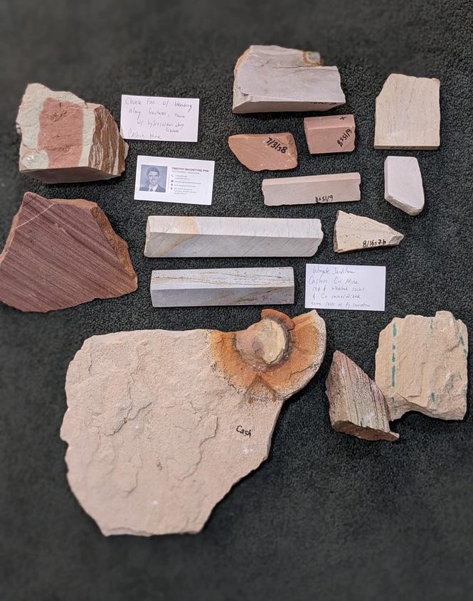
Tim MacIntyre, PhD, donated several samples (Figure 3) from his graduate school work on the Chinle Formation at the Cashin Mine in Montrose County, Colorado. He also included a handout describing the soft rock metallic ore deposit found at the Cashin Mine. His samples include Wingate Sandstone with Cu mineralization, Chinle Formation showing bleaching along fractures and hydrocarbon staining, and a beautiful example of a burrowing layer in the Chinle Formation. These rocks are great educational examples of the mineral deposits found in the mineral belts of Colorado.
Terry Mather of Castle Rock gave us four rock samples for our Colorado Rock collection. Terry’s donation (Figure 4) included several samples of lava bombs from the Flat Tops that are a wonderful compliment to Fred’s lava bomb, a sample of the Dakota Formation with a great example of crossbedding from Horsetooth reservoir, a sample of Mahogany Oil Shale from the Green River Formation in western Colorado and several pieces of petrified wood from near Kiowa Colorado. This donation shows the wide variety of rock types and resources found within our boarders.
Thank you to all these fossil and rock donors for their work and donations. These donations will be used to education many students and youth on the geological processes and resources found in Colorado and may inspire a few to go on to careers in one of the many geoscience fields.

It was a very successful fundraising year for the RMAG Foundation in part because of two special fund drives:
• We were able to capitalize on several major challenge gifts that allowed us to match contributions to the Robert Cluff Scholarship 3 to 1. The results were a significant financial success, allowing us to increase the Cluff Scholarship amounts in the coming years.
• Monetary gifts to the Bolyard Family Scholarship were encouraged in memory of Dudley Bolyard and graciously planned by Dudley and Marion
• Patricia Irwin
• Jane Estes-Jackson
• Laura Wray
• Jeanne Wilde
• Grace and Andrew Shearer
• Robert and Kathryn Garvin
• Lloyd and Mary Edwards
• Robert and Barbara Tucker
• John Harris & Vivien
Loughheed
• William Donovan
• E. Kay and Troy Waller
• M. Ray Thomasson & Merrill Shields
• Russell Bolyard & Callie English-Bolyard
• Louis and Shirley Bortz
• Connie Knight
• Stephen and Julie Purdum
• Allen McGlone & Eric Steven McGlone
• Steven Veal
• Elizabeth McKenna
• Ginny and Jonny Gent
• Rob Dietrich and Mary Ann Dyka
• Tim Schowalter
• Robbie Gries
• Paul and Ernestine Stewart
• Phillip and Janet Kersey
• Forrest G. Poole
• Elmo and Kathy Brown
• Carol Robinson
• Ira Pasternack
• Sue Cluff
• Terri Olson
• J. Frederick Sarg
Bolyard and their family. That fund grew substantially as well.
We thank ALL the donors for their generous contributions last year which allow us to continue funding scholarships, RMAG programs, and student memberships to RMAG. In addition, we can continue to provide financial support for geoscience organizations and school programs. We expect that our philanthropic donations can expand due to the generosity of the RMAG community.
• David Nelson
• Mark Longman
• Tanya Inks
• Arthur Butler III
• Donna Anderson
• Danielle Ebnother
• Matt Silverman
• William Stephens
• David Nelson
• Jane Crouch
• Mark Sonnenfeld
• Robert Coskey
• Ira Pasternack
• Laura Wray
• Bob Lamarre
• Bob and Barbara Tucker
• Nathan Rogers
• David Nelson
• Mark Sonnenfeld
• Holly Lindsay
• Ben Burke
• Gibbet Hill Foundation
• Ron Pritchett
• David Taylor
• Bruce Wiley
• Douglas Carlson
• Nick Eberly
• Debra Higley
• Ashley Kim
• Kurt Reisser
• Phil Moffitt
• Arthur Curtis
• Debra Higley
• John McLeod
• Lisa Wolff
• Ernest and Debra Gomez
• Stephen Strachan
• SM Energy Matching Gift
• Elmo and Kathy Brown
• Joyce Babcock
Premier, pay-as-you-go E&P software.

With the Shale Production Optimizer, you now have access to the most popular PIPESIM workflows in one, intuitively simple, pay-as-you-go subscription service. Design your wells. Run artificial lift optimization scenarios. Identify potential bottlenecks in production. Make better decisions based on data—not guesswork.
Learn more at commerce.slb.com/production
Shale reservoirs are complex. This isn’t.
The RMAG Foundation Trustees reviewed 32 graduate student scholarship applications representing twelve different universities during the month of January. In early February the Trustees granted ten scholarships totaling $44,100. The diversity of thesis and dissertation topics shown below reflects the increasing variety in geoscience research being conducted by the participating universities.
The Philip J. McKenna Scholarships listed below are awarded to two outstanding Colorado College undergraduate students nominated by the Geology department faculty.

All the applicants and their advisors will receive a one-year free RMAG membership from the RMAG Foundation. The RMAG Foundation Trustees congratulate these students for their outstanding academic successes and thanks all RMAG Foundation donors for sustaining these scholarship.
GARY BABCOCK SCHOLARSHIP
David Nworie, MS candidate – Colorado School of Mines
“Carbonate sediment-gravity-flow experiments: How do particle characteristics affect flow structure, deposit texture, and reservoir quality in deep-marine settings?”
Shayla Triantafillou, MS candidate – Colorado State Univ.
“Geomorphic factors influencing magnitude of post wildfire disturbance response”
ROBERT M. CLUFF SCHOLARSHIP
Maximiliano Miguez, MS candidate – Colorado School of Mines
“Multi-scale analysis of carbonate mass transport deposits, Apache Mountains, Texas.”
COLORADO SCHOOL OF MINES SCHOLARSHIP
Admad Tourei, PhD candidate – Colorado School of Mines
“Ambient noise interferometry Using distributed acoustic sensing to study permafrost degradation in Arctic Alaska”
NORMAN H. FOSTER SCHOLARSHIP
Patrick Sullivan, PhD candidate – Colorado School of Mines
“Origin and Stratigraphy of Enigmatic Sandstones of the Cretaceous Western Interior Seaway: the Late Turonian Wall Creek-Turner System, Powder River Basin, WY”
MICHAEL S. JOHNSON SCHOLARSHIP
Brigham Cardon, MS candidate – Brigham Young Univ.
“Structural analysis of the Sand Wash fault zone with geophysical applications”
STONE-HOLLBERG SCHOLARSHIP
Luke Basler, MS candidate – University of Idaho
“Testing models of orogenic collapse in the Rocky Mountains using stable isotope paleoaltimetry”
VETERANS MEMORIAL SCHOLARSHIP
Patricia Standring, PhD candidate – University of Texas, Jackson Inst. For Geophysics
“Ocean circulation changes in the Western Atlantic, Caribbean Sea, and Gulf of Mexico during the Eocene-Oligocene Transition”
» CONTINUED ON PAGE 41
» CONTINUED FROM PAGE 40
Molly McCreary, PhD candidate – University of Utah
“Mapping a landslide in Serpentine Valley in Prince William Sound, Alaska”
Emma Revenaugh, Junior – Colorado College
“Geochemical Analysis of Alpine Lakes in the Uinta Range, Utah, to Characterize Risk of Eutrophication in Alpine Lakes”
Mackenzie Boyd, Junior – Colorado College
“Paleoecology of Mammals across the K-Pg Boundary in the Southern Denver Basin”
MARCH 1, 2023
RMAG Luncheon. Speaker: Elizabeth Horne. “Interpretation, Characterization, and Rupture Hazard Assessment of Faults in the Permian Basin.” Online or In-person at Maggiano’s, Denver. 12:00 PM-1:00 PM.
MARCH 7, 2023
RMAG Women’s Group Coffee.
Vibe Coffee & Wine, 1490 Curtis St. 10 AM-11 AM.
DPC Lunch and Learn.
Speakers: Tyler Pittenger and Anthony Maltese of Pioneer Energy. “Deploying Tankless, Zero-Emission
Wellsite Production Systems in Liquids Rich Basins.” 11:30 AM- 1:00 PM at DERL, 730 17th St.
Suite B-1, Denver. Contact: Gabby Richmond (gabby@ denverpetroleumclub.com).
MARCH 8, 2023
COGA Colorado Oil and Gas Day at the Capitol. 8:30 AM-10:00 AM.
MARCH 9, 2023
WOGA Technical Lunch. ”Case Studies of a Fracture Geometry Control Methodology in Combination with Optimized Completions Design to Eliminate H2S Production, Reduce Water Cut and Improve Well Performance.” Email at info@ wogacolorado.org.
MARCH 11, 2023
Rmag On The Rocks
Behind the Scenes Tour
of the Denver Museum of Nature and Science.
MARCH 17, 2023
WOGA Virtual Lean-In.
Speaker: Uma Golpaldass. Via Zoom 11:00 AM-12:30 PM
MARCH 21, 2023
DWLS Luncheon.
Speaker: Darby Witt. “Cluster Efficiency Logging (Before and After Fracturing)- Cordax Improvements in Completion Diagnostics.”
MARCH 22-23, 2023
RMAG North American Helium Conference.
Westin Westminster, 10600 Westminster Boulevard.
The RMAG Outcrop editors reviewed the 2022 publications and voted on the Best Lead Article and Best Cover Photo awards. As always, the decision was difficult, with a variety of interesting, unique and impactful articles and photos published. We greatly appreciate all of the efforts to contribute to The Outcrop over the past year.
The winner for the Best Lead Article of 2022 is Louis D. Hose’s “A World-Class Gem: In the Middle of the Basin and Range – Lehman Caves isn’t just another roadside attraction” published in the December issue. The Outcrop committee found this article to be a very entertaining and informative lead article, and was especially impressed with the multitude of eye-catching, high quality figures and images embedded within the article. We additionally would like to recognize the significant efforts by Jane Estes-Jackson, Donna Anderson, and Matt Silverman,

to produce the four-part RMAG Centennial series throughout last year. Readers greatly appreciated learning about our history, and it was an excellent way to celebrate 100 years of RMAG!
The Best Cover Photo award also comes from the December issue, with Dave Bunnel’s photograph exploring the Gypsum Annex of Lehman Caves. The photograph was a favorite for its unique composition, with the scale of the cave contrasted to that of Dave’s fellow spelunker.
The RMAG Outcrop editors would again like to thank all of our 2022 article authors and photographers. We encourage all of our readers to review the interesting articles from this last year, and to reach out if interested in submitting a future article or cover photo!
The Outcrop Editors
Scott Bowles
is VP of Operations at The Cobalt Group, LLC and lives in St. George, Utah.
Michael Braunscheidel lives in Golden, Colorado.
Mason Dykstra is Vice President at Enthought and lives in Lafayette, Colorado.
Wesley Franklin
is a Geologist at Mantle Oil & Gas, LLC and lives in Friendswood, Texas.
Daniel Halford
is a student at University of Oxford and lives in Fullerton, California.
J L Jones is an Independent Geologist and lives in San Antonio, Texas.
Thomas Kirkwood is works for Wesco Operating Inc and lives in Casper, Wyoming.
Darren Kirkwood is an Engineer at Kirkwood Companies and lives in Evergreen, Colorado.
Dietrich Landis
is Mgr Acquistion Sales and BD at NodalSeismic and lives in Signal Hill, California.
Jim Levy
is President at Green Energy Minerals Inc. and lives in El Paso, Texas.
Chad Linzman
is a Consultant at Gaia Earth Technologies and lives in Thornton, Colorado.
Genga Nadaraju is VP Subsurface at Avanti Helium Corporation and lives in Calgary, Colorado.
Sandra Perry
is a Senior Geologist, Partner at Perry Remote Sensing LLC and lives in Denver, Colorado.
Michal Ruder is President at Wintermoon Geotechnologies Inc and lives in Glendale, Colorado.
Tim Rynott is CEO at Four Corners Helium, LLC and lives in Durango, Colorado.
James Wood works at Calaber1 Resources and lives in Calgary, Alberta.
Why contribute?
• Reach a broad industry and academic audience
• Quarterly peer-reviewed journal

• Permanent archiving includes AAPG Datapages

• Quick turn-around time
• Every subdiscipline in the geosciences
Expanded geologic focus:

• Entire greater Rocky Mountain area of North America
• West Texas and New Mexico to northern British Columbia
• Great Plains and Mid-Continent region
Email: mgeditor@rmag.org
https://www.rmag.org/publications/the-mountain-geologist/


RMAG’s Educational Outreach committee wants to create a collection of Colorado rocks that can be paired with the Colorado geological map. The committee will use these rocks as an educational tool to teach elementary, middle, and high school students about the geology of Colorado, geological processes, and Colorado mineral resources.

While you are on your summer vacations to the many wonderful areas in Colorado, please consider picking up rocks for our collection. We ask you note where you collected the rocks and the formation name. ROCKD is a great app that uses your location and geological maps to “map” the formation under your feet. Keep in mind to collect rocks where it is allowed.
Some examples of rocks from formations that we would love in our collection:
• Maroon
• Leadville
• Chinle
• Green River
• Navajo/Nugget
• Entrada
• Lodore
• Dakota
• Sawatch
• Igneous and Metamorphic rocks
• Wasatch
• Volcanics (San Juan – Flat Tops)
When your rocks are ready, contact us at edoutreach@rmag.org
Thank you!


