Volume 73 • No. 4 • April 2024 OUTCROP Newsletter of the Rocky Mountain Association of Geologists

2024 OFFICERS AND BOARD OF DIRECTORS RMAG STAFF
PRESIDENT
Mike Tischer mtischer@gmail.com
PRESIDENT-ELECT
Matt Bauer matthew.w.bauer.pg@gmail.com
1st VICE PRESIDENT
Lisa Wolff lwolff@bayless-cos.com
1st VICE PRESIDENT-ELECT
Nate La Fontaine nlafontaine@sm-energy.com
2nd VICE PRESIDENT
Jason Eleson jason@geointegraconsulting.com
2nd VICE PRESIDENT-ELECT
Ali Sloan ali@sloanmail.com
SECRETARY
Drew Scherer flatirongeo@gmail.com
TREASURER
Holly Lindsey hrlindsey@bafatoy.com
TREASURER-ELECT
Astrid Makowitz astridmakowitz@gmail.com
COUNSELOR
Steve Crouch scrouch@whiteeagleexploration.com
Rates and sizes can be found on page 53. Advertising rates apply to either black and white or color ads. Submit color ads in RGB color to be compatible with web format. Borders are recommended for advertisements that comprise less than one half page. Digital files must be PC compatible submitted in png, jpg, tif, pdf or eps formats at a minimum of 300 dpi. If you have any questions, please call the RMAG office at 720-672-9898.
Ad copy, signed contract and payment must be received before advertising insertion. Contact the RMAG office for details.
DEADLINES: Ad submissions are the 1st of every month for the following month’s publication.
The Rocky Mountain Association of Geologists (RMAG) is a nonprofit organization whose purposes are to promote interest in geology and allied sciences and their practical application, to foster scientific research and to encourage fellowship and cooperation among its members. The Outcrop is a monthly publication of the RMAG. 730 17th Street, B1, Denver, CO 80202 • 720-672-9898 The Outcrop is a monthly publication of the Rocky Mountain Association of Geologists ADVERTISING INFORMATION
EXECUTIVE DIRECTOR
Bridget Crowther bcrowther@rmag.org
LEAD EDITOR
Nate LaFontaine nlafontaine@sm-energy.com
CONTRIBUTING EDITORS
Elijah Adeniyi elijahadeniyi@montana.edu
Marlee Cloos marlee.cloos@bpx.com
Danielle Robinson danielle.robinson@dvn.com
RMAG CODE OF CONDUCT
RMAG promotes, provides, and expects professional behavior in every engagement that members and non-members have with the organization and each other. This includes respectful and inclusive interactions free of harassment, intimidation, and discrimination during both online and in-person events, as well as any content delivered by invited speakers and instructors. Oral, written or electronic communications that contain offensive comments or demeaning images related to race, color, religion, sex, national origin, age, disability, or appearance are not appropriate in any venue or media. RMAG reminds members of the diversity and mission statements found on our website. Please direct any questions to staff@rmag.org
DESIGN/LAYOUT: Nate Silva | n8silva.com
Vol. 73, No. 4 | www.rmag.org 3 OUTCROP | April 2024 Vol. 73, No. 4 | www.rmag.org 3 Outcrop | April 2024
OUTCROP Newsletter of the Rocky Mountain Association of Geologists

FOR MORE INFORMATION ON THESE EVENTS AND TO SEE WHAT ELSE IS COMING VISIT: www.rmag.org/events
JANUARY FEBRUARY MARCH APRIL MAY JUNE 11* 27 26 25* 21 25 JULY AUGUST SETEMBER OCTOBER NOVEMBER 30 27 24 29 19
TUESDAY 4PM *THURSDAY JANUARY FEBRUARY MARCH APRIL MAY JUNE 10 7 6 3 1 5 JULY AUGUST SETEMBER OCTOBER NOVEMBER DECEMBER 10 7 11 2 6 4 LUNCHEON LUNCHEON LUNCHEON WEDNESDAY 12PM JANUARY FEBRUARY MARCH APRIL MAY JUNE 18 22 21 18 16 20 JULY AUGUST SETEMBER OCTOBER NOVEMBER 18 15 19 17 21 COFFEE HOUR COFFEE HOUR COFFEE HOUR THURSDAY 10AM MARK
2024 NETWORKING EVENTS 2024 NETWORKING EVENTS 2024 NETWORKING EVENTS
HAPPY HOUR HAPPY HOUR HAPPY HOUR
YOUR CALENDARS
COVER PHOTO
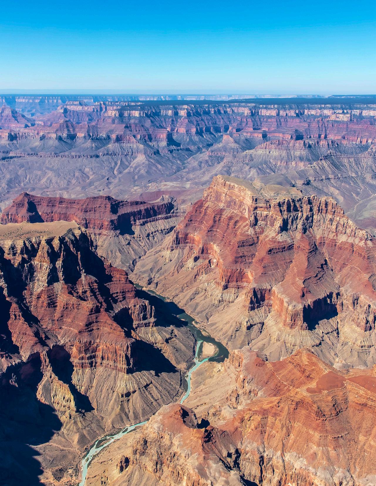
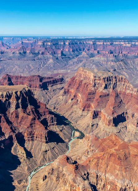
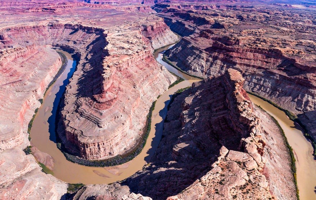
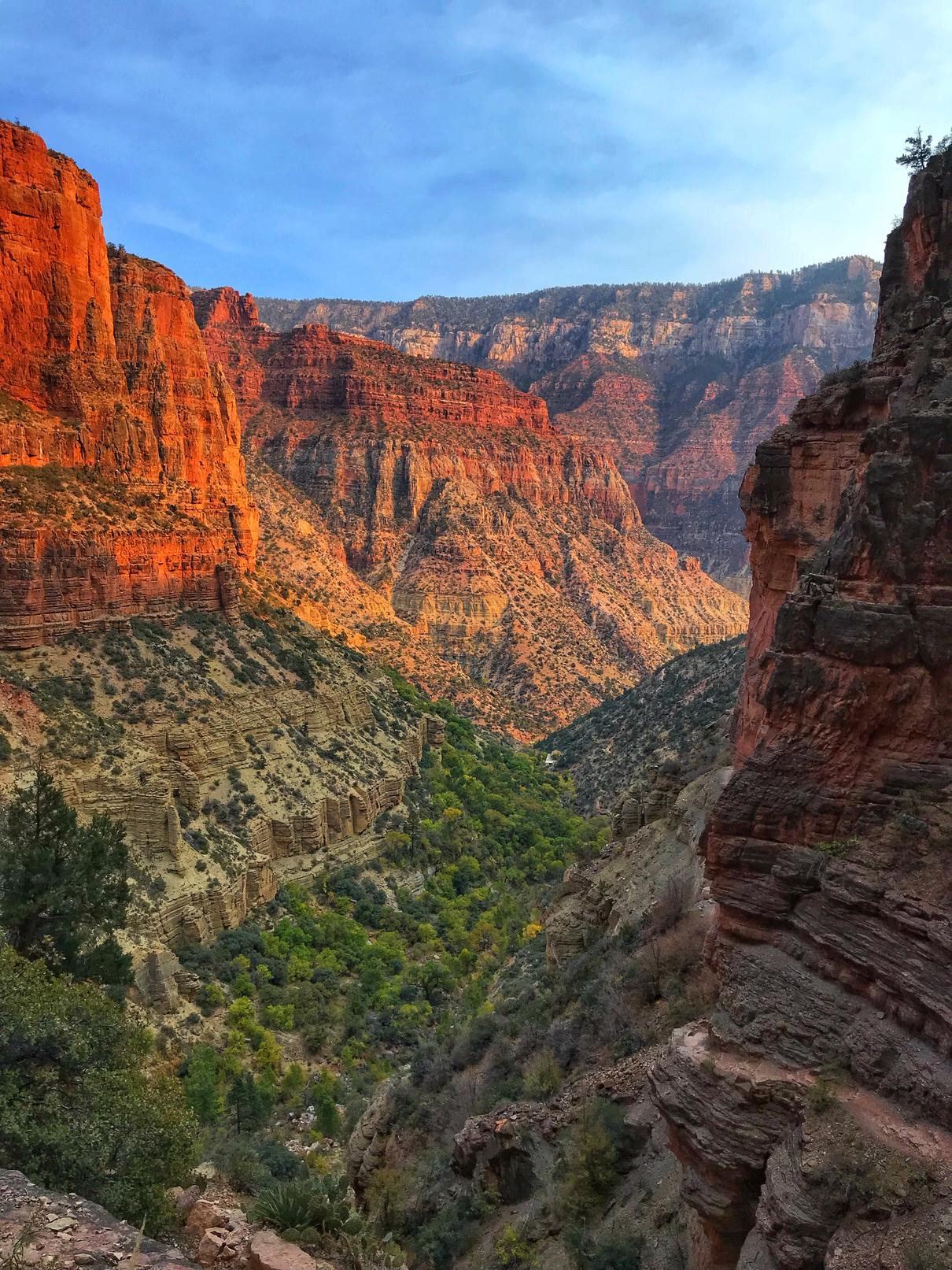
Oblique aerial view looking southwest over the confluence of the Little Colorado River (turquoise blue) with the Colorado River (dark green) in Marble Canyon. Downriver is toward upper left. Beginning in the foreground and moving back, overlooking the confluence are: Cape Solitude at left center, Chuar Butte at right center, red Temple Butte left of Chuar Butte; Crash Canyon between the two buttes; Chuar Valley behind buttes; tree-topped Walhalla Plateau / North Rim behind Chuar Valley; Grand Canyon behind Walhalla Plateau; Coconino Plateau / South Rim on skyline behind Grand Canyon. Photo courtesy of Ted Grussing, taken from his motorized glider (tedgrussing.com).
OUTCROP Newsletter of the Rocky Mountain Association of Geologists FEATURES 6 2024 RMAG Summit Sponsorship Packet 16 Lead Story: Tales of a Grand Canyon, Geologic Highlights of a Colorado River Trip– Part 1 46 Book Review: Water, Water, Not Everywhere DEPARTMENTS 10RMAG March 2024 Board Of Directors Meeting 12 President’s Letter 40 Hybrid Lunch Talk: Karen Lechtenberg 42 Hybrid Lunch Talk: Sarah Compton 52 In The Pipeline 53 Outcrop Advertising Rates 53 Welcome New RMAG Members! 54 Advertiser Index 54 Calendar ASSOCIATION NEWS 2 RMAG Summit Sponsors 4 RMAG Networking Events 11 On-The-Rocks: Raft The Grand Canyon 15 On-The-Rocks: Cave Of The Winds And Manitou Spings 21 RMAG Monthly Coffee Hour 27 RMAG Monthly Happy Hour 37 On-The-Rocks: Red Rock Canyon Open Space Field Trip 39 Best Outcrop Cover of 2023 41 Best Outcrop Article of 2023 43 Consider Publishing In The Outcrop 44 The Mountain Geologist Best Paper Award for 2023 50 RMAG Foundation Scholarship Winners
CONTENTS
Vol. 73, No. 4 | www.rmag.org 5 OUTCROP | April 2024
EVENT ATTENDEES WEBSITE VISITORS OUTCROP READERS
EMAIL SUBSCRIBERS
NETWORKING EVENTS
EDUCATION EVENTS
TRIPS

MEMBERS
DOLLARS SUPPORTED: 1,200 2,000 8,000 8,500 5,000 3,500 30 15 9
CONTINUTING
FIELD
COMMUNITY CONTACTS IN 2023 YOUR SUMMIT SPONSORSHIP
Geoscience Community:
We greatly appreciate every Summit Sponsor and Event Sponsor that has contributed to RMAG over the last year. We could not exist without your support
The Rocky Mountain Association of Geologists celebrated a year of remarkable achievements, bringing together a global community of over 300 geologists for the Helium Conference for one of the first events exploring Helium production from exploration to processing. Monthly Women's Coffee, Membership Happy Hours, and thematic luncheons provided a supportive networking environment. In these gatherings, experts delved into diverse subjects, with topics that spanned from landslides to the intricate geology of the Permian Basin. RMAG also offered classes on oil and gas property valuation, enriching the skill set of members. A core workshop facilitated hands-on learning, and field trips to quarries, crater impacts and other geologic marvels ignited the spirit of exploration. Notably, the association extended its community impact through outreach at community festivals and classrooms across the Denver Metro area, emphasizing our dedication to advancing geological understanding and appreciation.
2024 brings new opportunities for RMAG Your sponsorship dollars will help RMAG bring to fruition an extensive calendar of continuing education opportunities, an exciting Field Trips season, and a dynamic list of luncheon speakers on topics ranging from the state of the industry to hydrogen and more. These dollars will allow RMAG Members impact the next generation at outreach events throughout the community and provide opportunities for the geoscience community to connect and build their network.
Your sponsorship dollars will also support our excellent publications including the monthly Outcrop newsletter and the quarterly Mountain Geologist journal We recognize your financial commitment with inperson signage, and website and publication advertising, as well as through social media before each online event. With a LinkedIn group of almost 3000 members, we make our sponsors visible to the geoscience community for both virtual and in person events
Thank you to those who are already a Summit Sponsor, we look forward to your continued support in 2024. If you are not already a sponsor, please look at the many complementary benefits included with the sponsorship levels. If our annual sponsorships don't make sense for your company, or you want to sponsor something specific, ask about our single event sponsorship opportunities. Please feel free to contact our staff with questions about sponsorship by email: bcrowther@ rmag.org or by phone at 720-672-9898 ext. 102
We and the staff of RMAG thank you all for your continued support and look forward to seeing you in 2024.
Michael Tischer
Bridget Crowther
2024 RMAG President RMAG Executive Director

Vol. 73, No. 4 | www.rmag.org 7 OUTCROP | April 2024
(720)672-9898
17th Street,
P:
staff@rmag.org www.rmag.org 730
B1 Denver, CO 80202 October 20, 2023

OUTCROP | April 2024 8 Vol. 73, No. 4 | www.rmag.org RMAG ANNUAL SUMMIT SPONSORSHIP PLATINUM, GOLD, & SILVER SPONSORSHIP LEVEL PLATINUM GOLD SILVER Contribution Level Monthly Cost $10,000 $835 $5,000 $417 $2,500 $208 Benefits Value $10,000 $5,000 $3,000 RMAG MEMBERSHIP Active or Associate Membership in the Association for employees 4 2 1 RMAG WEBSITE BENEFITS Company Logo on Summit Sponsor Page of www.rmag.org Large Logo & Link Medium Logo and Link Small Logo and Link Articles and Ads on special Advertisers web page 4 articles & 4 large ads 2 articles & 2 medium ads 2 small ads PUBLICATION ADVERTISING 12 months of Outcrop advertising: To receive 12 full months, company logos and ad art must be received no later than the 20th of the month in which you register. The Outcrop (receive benefits for 12 issues, monthly online publication Full page ad 2/3 page ad 1/2 page ad Company Logo listed as an annual Sponsor in The Outcrop Large Logo Medium Logo Small Logo EVENT ADVERTISING Sponsorship will be
at all RMAG Events. Additional Sponsorship
be
for
Company Logo Looping in Slide Decks Large logo individual Slide Medium logo Small Logo Company Logo on Summit Sponsor Signage at all events Large logo Medium Logo Small logo RMAG EDUCATION EVENTS Registration points are
e and can be used for Symposiums or Short Courses. For example a Platinum Sponsor can send 4 people to the 2023 North American Helium Symposium, and register for 4 short courses. Total Educational Tickets 6 3 1 RMAG SOCIAL EVENTS Registration Points are c u m u l a t i v e and can be used for any social event. For example, 1 point means 1 golfer, or 1 registration for Rockbusters. *2 points can be used for a golf hole if that makes more sense for your company. Total Social Event Tickets 8 4 2 RMAG LUNCHEONS & FIELD TRIP TICKETS Registration Points are cumulative for luncheons or one day field trips. Total Luncheon & Field Trip Tickets 5 3 2 For all event tickets please contact the RMAG office at staff@rmag.org to use your spots.
acknowledged as part the summit sponsors
Opportunities will
available
all RMAG Events.
c u m u l a t i v
All sponsor benefits event tickets follow RMAG event registration deadlines. All benefits end 12 months after registration.
RMAG 2024 ANNUAL SUMMIT SPONSOR OPPORTUNITIES
Platinum Sponsor
Gold Sponsor
Silver Sponsor
Summit Sponsorship benefit term is for 12 months! Specify type of payment on signed form, and send logo and advertisements to staff@rmag.org
#:
Date: Security Code: Signature: ACH: contact the RMAG office at staff@rmag.or for directions
Mail Checks payable to RMAG: Rocky Mountain Association of Geologists (RMAG) 730 17th Street, B1 Denver, CO 80202
RMAG events are subject to change. Cancellation or rescheduling of events does not give the sponsor the right to refund. Summit Sponsors will receive benefits at any new events added into the RMAG schedule.
Thank you for your generous support!
P: (720)672-9898
staff@rmag.org www.rmag.org 730 17th Street, B1 Denver, CO 80202

Vol. 73, No. 4 | www.rmag.org 9 OUTCROP | April 2024
RMAG 2024 SUMMIT SPONSORSHIP Payment Options
Company Representative: Address: City: State: Zip Code: Phone: Email: Payment Method: Credit Card ACH Check Credit Card Information: Select Card:
VISA Discover Name
Credit
Company:
AMEX Mastercard
as it appears on Credit Card:
Card
Expiration
RMAG MARCH 2024 BOARD OF DIRECTORS MEETING
By Drew Scherer, Secretary flatirongeo@gmail.com
Just like the snow in the Front Range, we have events piling up this year, so it should be a great spring and summer ahead! The board met Wednesday, March 20th at 4:00pm online with all members but one present. While some of our early events this year were smaller in capacity they were very well attended, such as the February Luncheon with Mike Blum and the trip to the Ice Core lab in the Federal Center. We also have forty-five new members in the org, including many students, welcome!
A couple events of events for April include our Luncheon with Karen Lechtenberg of Carbon America presenting on CCUS well permitting, a short course titled “Practical Python for Earth
Scientists” hosted by our own Matt Bauer, an OnThe-Rocks field trip to the Cave of the Winds and Manitou springs, RMAG Coffee Hour at Huckleberry Roasters, and a jointly hosted Happy Hour with the Denver Well Logging Society (DWLS) at Joyride Brewing. Hopefully, we will see you out at one of our many events this month!
Lastly, closing out my introduction with some great news, the Denver Chamber of Commerce is recognizing businesses with over one hundred years of service to the mile high community and RMAG is being celebrated this spring as one of those companies and community organizations! Thank you for all your support over the years, here is to one hundred more!
production company
confluenceresources.com
Confluence Resources is an upstream exploration and production company confluenceresources.com

OUTCROP | April 2024 10 Vol. 73, No. 4 | www.rmag.org

Raft the Grand Canyon
Elves Chasm Gneiss
Redwall Cavern
Marble Canyon
Vasey’s Paradise
The Great, and lesser unconformities
And more!
$ 7,500 Members
$8,000 Non-Members
$ 1,000 non-refundable deposit required
Vol. 73, No. 4 | www.rmag.org
April 18 to May 1, 2025
WWW.RMAG.ORG/GRANDCANYON
Sites Include : LEARN MORE AND SAVE YOUR SPOT TODAY:
Save Save Saveyourspot yourspot yourspot
By Mike Tischer
Go Explore and Be Safe!
Dear RMAG Members,
Welcome to Spring! My backyard is slowly turning green and I can smell spring in the air. This month, I want to take the opportunity to highlight one of our most popular RMAG offerings. As the days are getting longer and the temperatures are rising, many of us will start to venture out into nature for a hike and look at rocks. Our own On the Rocks (OTR) committee is also awakening from its winter slumber to help you with that effort.
OTR, for folks who don’t know, is our field trip committee. Made up of some of the finest, most dedicated RMAG members, and led by the grandmaster of field trips, Rob Diedrich, this group of geoscientists works together yearround with our Executive Director, Bridget Crowther, to provide you with a set of field trip opportunities of exceptional quality. The work this group does is a big reason I joined RMAG many years ago, so I would be able to go on these spectacular field trips and mingle with like-minded rock nerds.
You can look forward to caves, volcanoes, fossils, and of course, plenty of other opportunities to touch and lick rocks. Please check out our ad page on page 13 for details and dates on the trips OTR is planning to run this year. And this is not all, more trips will be added over the next couple of months.
Let me assure you that this year isn’t any different. Field trip planning is in full swing. As a matter of fact, the season has already started with a virtual talk given by Rob D. just a few weeks ago about the history and geology of the Yule marble quarry. If you missed it, don’t fret as you can still watch the recording. Just send an email to the office (staff@ rmag.org) and ask for access. If you watched Rob’s talk to the end you saw a sneak preview of the field trip schedule for this year, and what a schedule it is!
OTR of course hasn’t been in ‘sleep mode’ during cold months, despite there being no trips offered. While this committee continues to produce high-quality trips year after year for a spring to fall season, it is worth pointing out that a lot of work goes into the planning and the setup of these events long before they take place. OTR has been hard at work for months contacting potential field trip leaders, setting up trip itineraries, working on logistics, and all the other things that need to be sorted before a trip can happen. Yet, of all the many things that need to be done before a trip can start, none of them
OUTCROP | April 2024 12 Vol. 73, No. 4 | www.rmag.org
LETTER
PRESIDENT’S
RMAG field trip to Corral Bluffs, near Colorado Springs.

April 1 5
June 8
June 2 9
Sept 7
Sept 2 1
Summer
2 0 2 4
April 18 to May 1
2 0 2 5
C a v e o f t h e W i n d s a n d M a n i t o u S p r i n g s
Visit the the Spring in Manitou Springs, learn about Hypogensis, get a lecture from the Cave of the Winds Historian, and a Private Tour inside the Cave of the winds
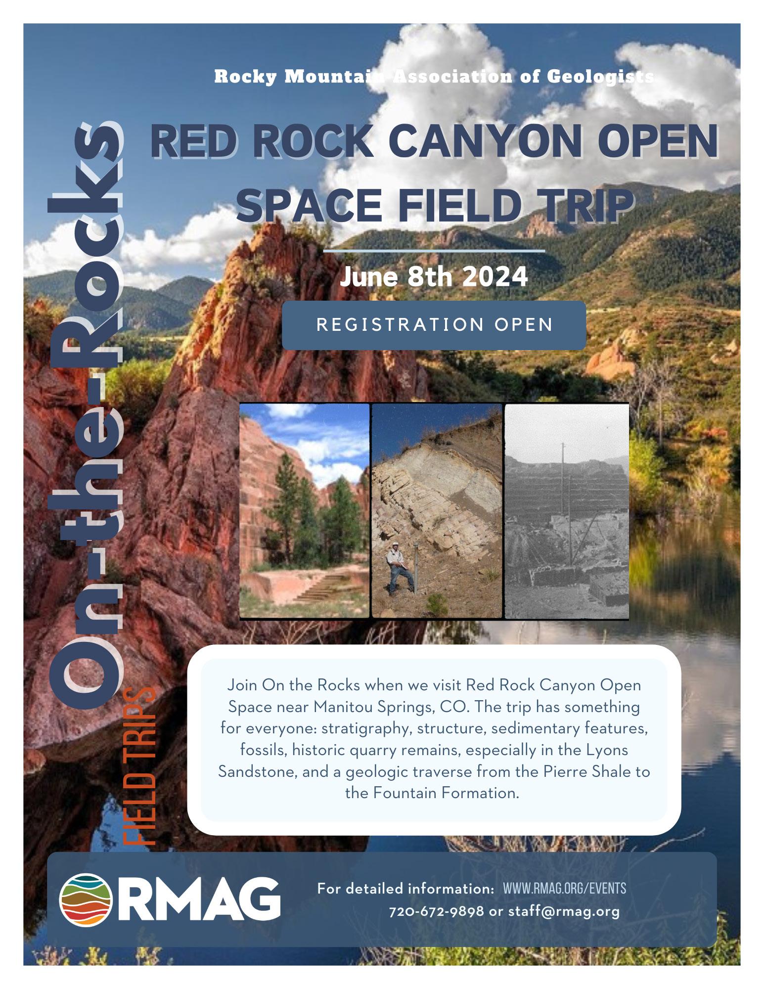
R e d R o c k C a n y o n O p e n S p a c e , C o l o r a d o S p r i n g s
Visit Red Rock Canyon Open Space near Manitou Springs and learn about the stratigraphy, structure, sedimentary structures, fossils, the historic quarry remains in the Lyons Sandstone, and a geologic traverse from the Pierre Shale to the Fountain Formation
G e o l o g y a n d P a l e o n t o l o g y o f t h e C a n o n C i t y A r e a
Join leaders Jon Stone & Lou Taylor to examine dinosaur trackways and bones in the Garden Park Fossil area and BLM land see vertebrate fossils in Harding Sandstone outcrop. Plus a tour of the Dinosaur Museum at Royal Gorge
P e r m i a n S t r a t i g r a p h y a n d D e p o s i t i o n a l S y s t e m s
A l o n g t h e N o r t h e r n C o l o r a d o F r o n t R a n g e
Join Marshall Deacon to Lory State Park in Fort Collins to examine the Lyons, Ingleside Formations eolian stratigraphy
E v a p o r i t e s , T u r b i d i t e s a n d S t r o m a t o l i t e s : A
W h i r l w i n d T o u r o f E a g l e B a s i n P e r m o - c a r b o n i f e r o u s
G e o l o g y
Trip leaders John McLeod & Dennis Gertenbach to explore Structural and Stratigraphic history of the Eagle Basin
s t o r i e s i n s t o n e : w a l k i n g t o u r o f c a p i t o l h i l l b u i l d i n g
s t o n e s
R a f t t h e G r a n d C a n y o n
a 14-day geology rafting and hiking adventure down the Colorado River through the Grand Canyon Professor Gary Gianniny will help guide you through the canyon ’ s astonishing record of the evolution of southwestern North America
Dates subject to change. View website for additional info.

A 2+ mile walking tour of some of downtown Denver’s iconic stone buildings, many of which are constructed with rock from Colorado quarries See Yule Marble, Pike’s Peak and S Beaver Creek Granites, and more! F
o
e t a i l e d i n f o r m a t i o n : w w w r m a g o r g / e v e n t s 7 2 0 - 6 7 2 - 9 8 9 8 o r s t a f f @ r m a g . o r g
i e l d T r i p s
i e l d T r i p s S c h e d u l e d f o r 2 0 2 4 a n d b e y o n d
o c k y M o u n t a i n A s s o c i a t i o n o f G e o l o g i s t s . . . s o f a r !
r d
F
F
R
PRESIDENT’S LETTER
is as important as ensuring safety. OTR takes this very, very seriously. And I very much applaud them for it. As a trip leader in the Colorado Mountain Club, I am keenly aware of the risks any outdoor activity holds, and so I appreciate the time and effort the OTR spends on minimizing this risk as much as possible.
If you have ever been on one of our trips, you will probably remember the safety form you have to fill out. This form collects important information to make sure that we know what to do in case you need help on one of our trips. In addition, the OTR will assess any safety risks and potential hazards for each field trip and for each stop if necessary. Of course, accidents can happen even with careful planning, so the OTR makes sure that on every trip we bring a first aid kit, a GPS enabled communication device and some extra gear, just in case.
Outdoor safety is not just important on our field trips but every time you go out on your own. And it starts with you. So, what can you do on your next outdoor adventure, either with RMAG or on your own? How can you be prepared? There are a few
things you should do every time you venture outside. Here is a short list:
• Tell somebody where you are going and provide them with a trip itinerary
• Check weather and traffic for the area you are visiting and travel to and from
• Always bring the 10 essentials (there are a few versions of this floating around on the web but here is a good start: https://en.wikipedia.org/wiki/ Ten_Essentials)
• Know your capabilities and limits
• Have fun!
If you follow these tips, you will minimize your risk exposure during any outdoor activity. It’s a bit of prep work on your part but it could make the difference between a good trip and a bad trip.
I hope you will have fun exploring Colorado’s spectacular scenery or wherever else you may roam. Stay safe! And who knows, maybe I will see you on one of our upcoming RMAG field trips? Until then, enjoy this April issue of the Outcrop.
OUTCROP | April 2024 14 Vol. 73, No. 4 | www.rmag.org
This first trip of the 2024 Field Trip season highlights the expertise of two prominent geologists and speleologists, Mark Maslyn and Harvey DuChene. We will begin by visiting several springs in Manitou Springs , a lecture by the cave ’ s historian and comparisons with cave hypogene speleogenesis in the Guadalupe Mountains. The culmination of the trip will be a private tour of the cave by Mark Maslyn who has mapped portions of the cave and led technical trips for forty years.

R E G I S T R A T I O N O P E N F o r d e t a i l e d i n f o r m a t i o n : www.rmag.org/events 7 2 0 - 6 7 2 - 9 8 9 8 o r s t a f f @ r m a g . o r g O nt h
R
O nt h eR o c
s F i e l d T r i p s R o c k y M o u n t a i n A s s o c i a t i o n o f G e o l o g i s t s A p r i l 1 3 , 2 0 2 4 C A V E O F T H E W I N D S A N D M A N I T O U S P R I N G S
e
o c k s
k
TALES OF A GRAND CANYON GEOLOGIC HIGHLIGHTS OF A COLORADO RIVER TRIP
PART 1
LEW KLEINHANS, Consulting Exploration Geologist & River Runner
MADELINE MARSHALL, Assistant Professor of Earth & Environment, Albion College
KJ McDONOUGH, KJM Consulting
INTRODUCTION
Welcome river runners… past, present, and those entertaining becoming one in the future!
We’re about to figuratively embark on a Grand Canyon river trip, recounting some geological highlights of a recent trip made down the Colorado River with two motorized pontoon boats chock full of geo-adventurers.
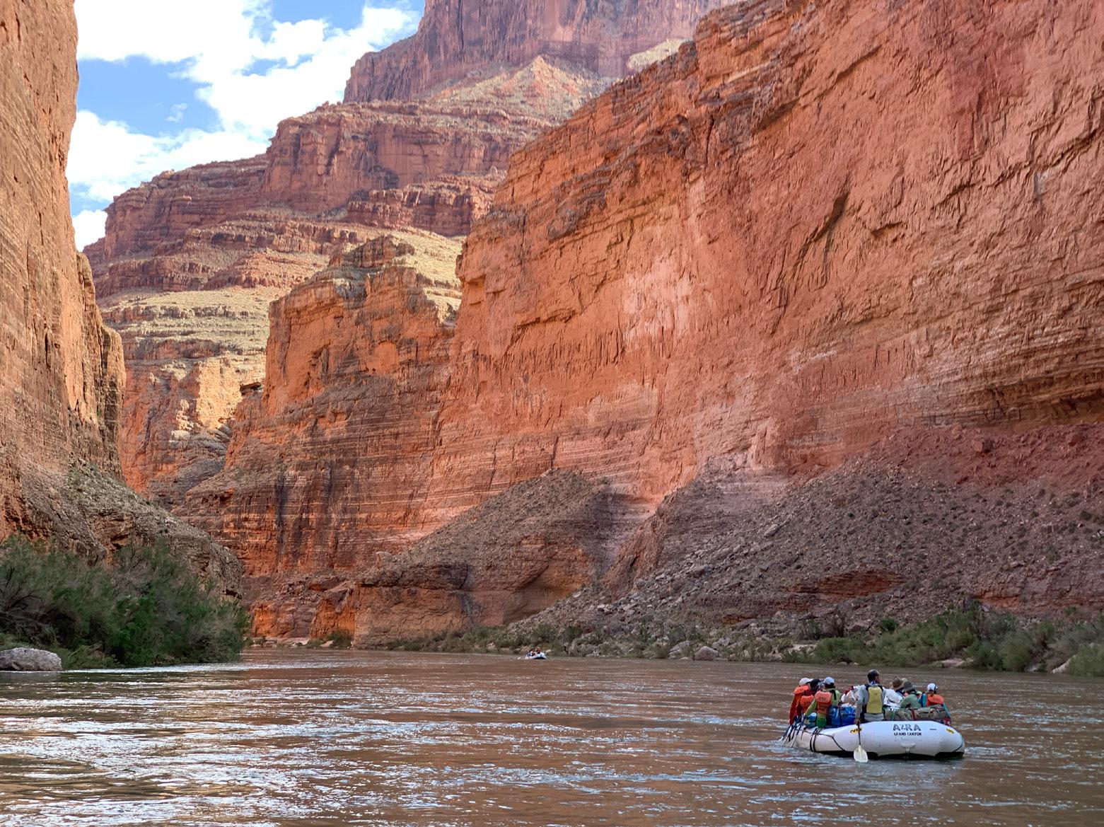
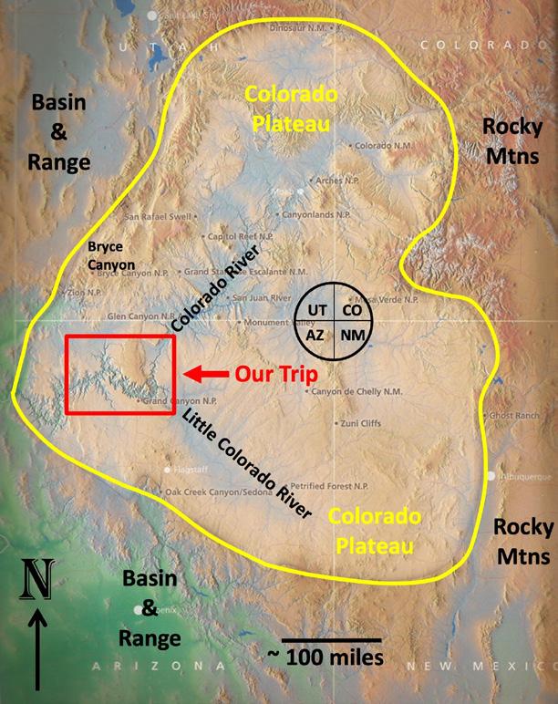
“Our Trip” (Fig. 0-1) was hatched and planned by geologist Lew Kleinhans (the “Oyster Guy”), who has led 20 Grand Canyon geology trips over many decades. Lew expertly led 27 geologists and geo-interested friends into deep geologic time, traversing the depths of the Grand Canyon, ably assisted by three of Hatch River Expeditions’ premier river guides.
We put in (began) at Lees Ferry and took out 9 days later by helicopter at Whitmore Helipad (“end” on Fig. 0-2). In those 187 river miles, we traversed
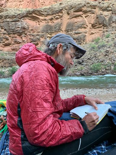
about 11,000 ft of stratigraphic section covering almost two billion years of geologic time. Between geology stops and side canyon hikes, we ran 80+ rapids, including the infamous Lava and Crystal rapids, and together rolled 7200 lbs of “pumpkins,” set up 240 cots (mostly correctly), and watched in awe as our guides (after long days navigating rapids, assisting Lew in geo-narration, hiking and exploring side canyons) brewed hundreds of cups of coffee, cracked >400 eggs and prepared 8 epic evening banquets for 30 (Fig. 0-3).
We were lucky to have active researchers along on the trip, giving everyone an opportunity to collaborate on and participate in ongoing geologic research projects in the Grand Canyon. These included research on: 1) the incised-valley systems and base-level changes of the Devonian Temple Butte Formation (Marshall and Warme, 2022); and the
OUTCROP | April 2024 16 Vol. 73, No. 4 | www.rmag.org
LEAD STORY
massive and distinctive Poncho’s Runup landslide (Warme, 2004; Elston et al., 1989).
Of the countless intriguing geologic features we encountered along the river, we highlight some of our favorites for you here. Geo-highlights are discussed in the eight topical sections that follow (Sections 1-4 in Part 1 in April, with Sections 5-8 to follow in Part 2 in May.) Sections are in sequential order beginning at Lees Ferry (Fig. 0-2). Approximate river-mileage starting and ending points are noted for each section. Our objective is to provide a brief field guide of geologic highlights in river-mileage format (e.g., RML 21.3 = “River Mile 21.3, left bank looking downstream”), following Belknap’s (2023) river mileages. Our hope is that this trip overview will serve as an introduction to the many more detailed publications that exist, as well as whet the appetites of future geo-adventurers and researchers. As you read through the following sections, the
FIGURE 0-1: Color-enhanced relief map of “Our Trip” (red box) relative to the Four Corners, Colorado and Little Colorado Rivers, Colorado Plateau Geologic Province (yellow outline) and surrounding provinces. From Bryce Canyon to the Colorado River (~85 miles), one descends the “Grand Staircase” through 15,000 feet of stratigraphy (after Blakey and Ranney, 2008).
amazing interconnectivity of features within the Grand Canyon will become increasingly apparent. For us, it’s one of the many compelling take-aways of our trip.
1. Permo-Triassic Boundary / Unconformity (RM 0-1)
2. Economic Geology, Hydrology and Plumbing Systems (RM 1-11.7)
3. Sequence Stratigraphy and Cyclicity (RM 11.7-37.8)
4. Temple Butte Formation Incised-Valley Systems and Root Traces (RM 37.8-52.5)
5. Nankoweap Delta Formation and Occupation (RM 52.5-57.3)
6. Incision Rates and River / Canyon Age (RM 57.3-137)
7. Landslides and Poncho’s Runu p (RM 137-175)
8. Recent (< 1 Ma) Volcanism (RM 175-187.4)
Vol. 73, No. 4 | www.rmag.org 17 OUTCROP | April 2024
FIGURE 0-2: Location of “Our Trip” and Grand Canyon relative to the Colorado and Little Colorado Rivers, surrounding plateaus, and Grand Canyon Village on the South Rim. The area spans indigenous territories including those of the Southern Paiute, Diné (Navajo), Hopi, Havasupai, Zuni, Hualapai, and YavapaiApache tribes. Circled numbers correspond to the approximate beginning points of the eight topical sections in text. Our “putin” (start of trip) is at No. 1 (Lees Ferry, RMR 0), and our “take-out” (end of trip) is at RML 187.4, the Whitmore Helipad (after Esri 2020).
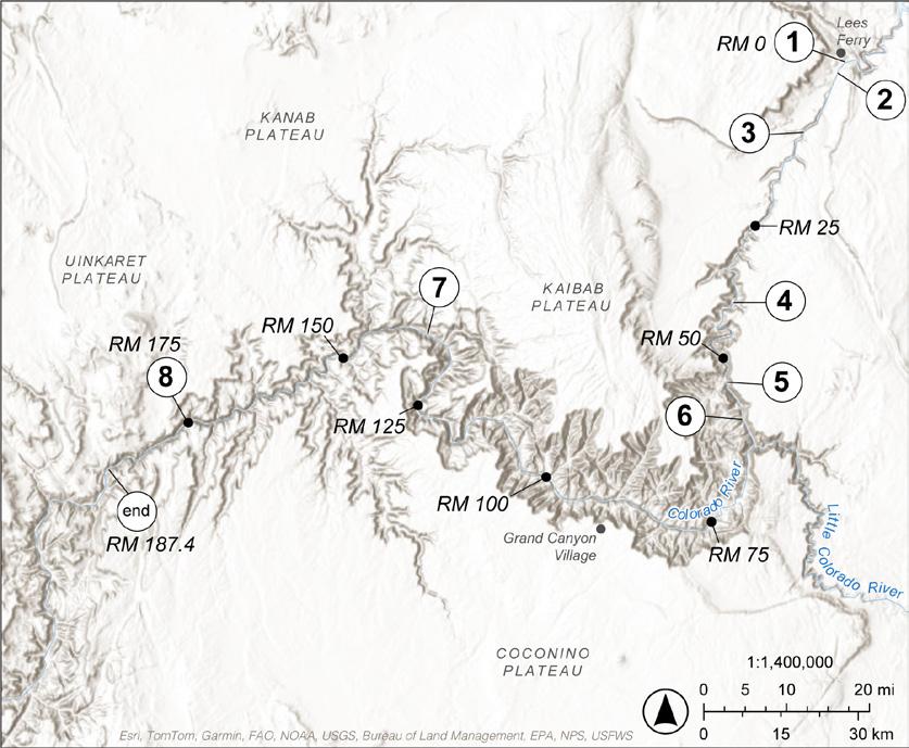
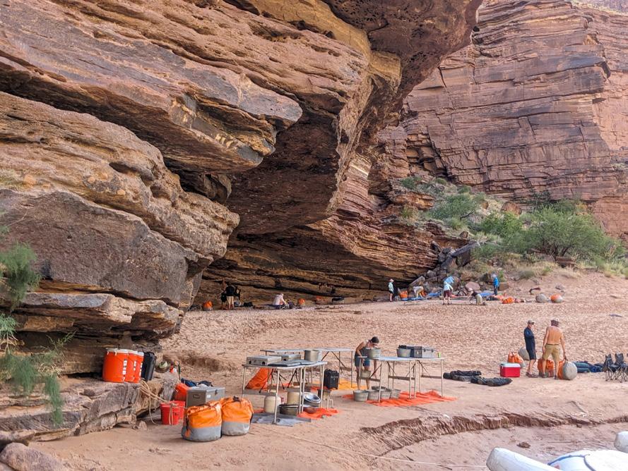
FIGURE 0-3: Our comprehensively outfitted river trip at Poncho’s Kitchen Camp (RML 137.6) including expert kitchen, “pumpkin” dry bags, capable campers, cots under construction, and fascinating rocks—in this case, Cambrian Tapeats Sandstone.
OUTCROP | April 2024 18 Vol. 73, No. 4 | www.rmag.org
GEOLOGIC SETTING
The yellow outline of the Colorado Plateau (Fig. 0-1) shows the location of the Colorado and Little Colorado River drainages (the confluence of which is shown in the cover photo), which collectively drain to the west, where the Colorado Plateau transitions into the Basin and Range and the Colorado River abruptly turns south. The drainage distribution and shape of the Colorado Plateau are useful in deciphering the timing and nature of the integration
of the Colorado River and formation of the Grand Canyon, a topic touched upon in Section 6.
The nearly 11,000 feet of section we encounter is only a portion of the ~15,000 feet of section that comprises “The Grand Staircase,” which is a stratigraphic downstepping from Bryce Canyon to the Colorado River (Fig. 0-1). Our river journey took us through all four major Grand Canyon rock groups (Fig. 0-4), which from bottom to top comprise: Group I (metamorphic and igneous basement), Group II (“tilted rocks”), Group III (“layered,
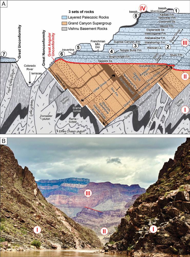
FIGURE 0-4: A. Schematic
E-W cross-section of the Grand Canyon region showing the four main “Groups” of rocks: Group I) Early Proterozoic (1840-1680 Ma) igneous and metamorphic basement; Group II) Middle + Late Proterozoic (1254-742 Ma) “tilted rocks”; Group III) Paleozoic (Cambrian-Permian, 508-240 Ma) “layered, flat-lying rocks,”; Group IV) Recent (<1 Ma) volcanic rocks. The major unconformities that separate them are: Great Nonconformity (white line), Great Angular Unconformity (red line), and Great Unconformity (black line) (after Karlstrom et al., 2021). Sections 1-8 of this article, also on the map in Figure 0-2, are labeled in their approximate stratigraphic locations. B. View downstream from RM 107-108 showing portions of the same three main rock packages. Red line marks Great Angular Unconformity on top of Group II rocks.
Vol. 73, No. 4 | www.rmag.org 19 OUTCROP | April 2024
STORY
LEAD
flat-lying rocks ”), and Group IV (recent volcanics).
The route of our river trip is like a “stratigraphic roller coaster,” which goes stratigraphically down, up, down, up, levels out a bit, and then ascends to strata younger than at the start. Specifically, we rode our roller coaster downstream and down stratigraphic section for the first 78 river miles—from the Triassic Moenkopi Formation at Lees Ferry through the entire Paleozoic section (Group III), through parts of the Late Proterozoic Grand Canyon Supergroup (Group II) and into the Early Proterozoic (Group I) in Upper Granite Gorge at RM 78. Then, our roller coaster carried us back up section past the Great Unconformity and into the Group III Cambrian Tapeats Sandstone once again. We then plummeted back down into the Group I metamorphic and igneous basement, including the oldest geologic unit, the 1.84 Ga Elves Chasm Gneiss (RM ~116). From there, we climbed up-section, leveled out for a while in the Group III Cambrian Muav Limestone, and then began our final ascent to the youngest (<1 Ma) Group IV volcanic rocks (RM ~177).
We observed both ancient and modern sedimentologic processes as we floated downriver, as well as manifestations of ancient metamorphic and igneous processes. Our time on the river provided ample opportunity to observe and appreciate fundamental geologic concepts such as “The present is the key to the past,” Deep Time and Uniformitarianism. The Grand Canyon and Colorado River continue to be both witnesses to and agents of profound change within their confines as well as within those experiencing them. In the words of some very experienced Grand Canyon researchers (Karlstrom et al., 2021), “... new and refined understandings of geology and deep time are essential for the future sustainability of our planet with limited resources and growing populations.”
1. PERMO-TRIASSIC BOUNDARY / UNCONFORMITY (RM 0-1)
It is profound and inspiring that the beginning and ending locations of our river trip expose some of the most significant geologic events recorded by the rocks in the Grand Canyon. We begin at the Permo-Triassic Boundary, which also happens to be an
“end,” i.e., an extinction event, as described below.
On the evening before our put-in, our view from Cliff Dwellers Lodge was to the south and southeast, across the eastern portion of the Arizona Strip. The Arizona Strip is a very sparsely populated but historic region which lies north of the Colorado River and Grand Canyon. This eastern part of the Arizona Strip is also called the Marble Platform, because it is underlain by the top of the flat-lying Permian Kaibab Limestone. Note that the term “marble” is a carry-over from the time of John Wesley Powell, when it referred to any polished carbonate rock.
The Marble Platform portion of the Arizona “Strip” is where the less resistant mudstones and sandstones of the Triassic Moenkopi Formation have been “stripped away”, exposing the more resistant Permian Kaibab underneath. That contact is known as the Permo-Triassic Boundary, which comprises an unconformity, also called the Tr-1 Unconformity, which is approximately 20 Ma in duration at this location (Pipiringos and O’Sullivan, 1978; Kwiatkowski, 2021). During the early part of that hiatus, life on this planet experienced the largest extinction event recorded and resulted in the demise of “81-94% of marine species and 70% of terrestrial vertebrate species” (Dal Corso et al., 2022).
Evolution suggests that humans would not likely be here today without the change that mass extinction catalyzed. Moreover, this event at the beginning of our trip opens the door to the possibility that an imminent, “bucket-list” river trip might also become a life-changing experience… in a positive sense, of course. Incidentally, one can put their finger on this unconformity at approximately RML 1.0, just downstream from our put-in at Lees Ferry (Fig. 1-1).
That we begin our trip at the Permo-Triassic Boundary is also profound because the boundary is characterized by features that foreshadow many of the section topics that follow:
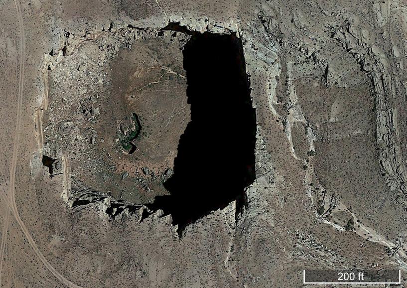
Figure 1-2, for example, is a Google Earth image of a collapse structure situated on the Marble Platform, just east of the Colorado River. Collapse structures are the product of carbonate rock dissolution and are significant when considering the economic geology, hydrology, and plumbing systems (e.g., aquifers and faults) of the Grand Canyon (Section 2).
Exposure, dissolution, erosion, karstification and
OUTCROP | April 2024 20 Vol. 73, No. 4 | www.rmag.org
LEAD STORY


Vol. 73, No. 4 | www.rmag.org 21 OUTCROP | April 2024 COFFEE HOUR MONTHLY, THIRD THURSDAY @ 10 AM APRIL 18, 2024 Free / RSVP AT RMAG.ORG/COFFEE Huckleberry RoastersDairy Block 1800 Wazee St. Denver, CO 80202 Sponsored By:
miles (2.5 km) due west of US Hwy 89A (Google Earth, 2019).
OUTCROP | April 2024 22 Vol. 73, No. 4 | www.rmag.org LEAD STORY
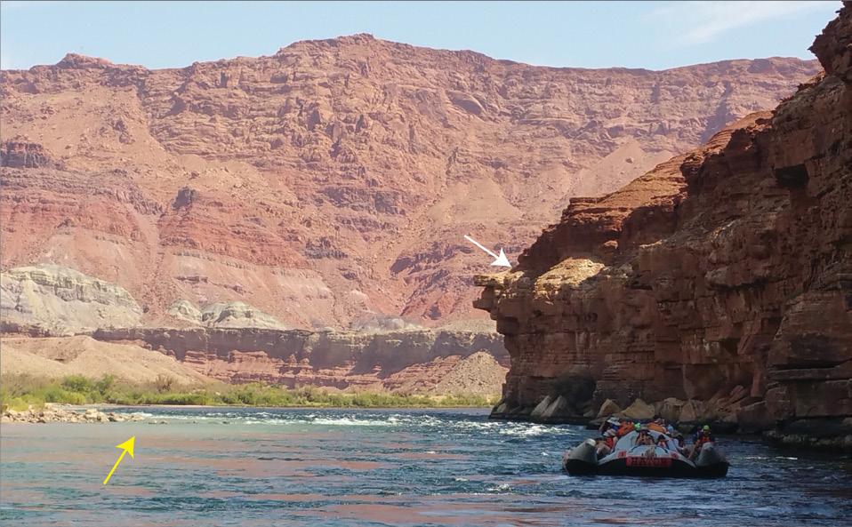
FIGURE 1-1: View looking approximately one mile upstream to the start of our trip at Lees Ferry (RM 0). The PermoTriassic contact (white arrow) is where relatively resistant, cliff-forming, whitish, Permian Kaibab Limestone beginning at river level is overlain by softer, slope-forming red sandstones and mudstones of the Triassic Moenkopi Fm. Light greenish water at left (yellow arrow) is where turbid contributions from the Paria River enter and mix with cold, crystal clear waters (surrounding raft) of the Colorado River, the latter having just exited Glen Canyon Dam approximately 15 miles upstream.
FIGURE 1-2: Near football-field-sized sinkhole on top of the Kaibab Limestone on the Marble Platform above and east of the Colorado River at Tanner Wash (RML 14.5). Note dirt roads for scale and structural (joint) control on sinkhole boundaries. This sinkhole is located on Navajo land, approximately 1.5
associated unconformities are critical concepts when considering sequence stratigraphic aspects of the Grand Canyon (Section 3).
Figure 1-3A depicts a local basal conglomerate of the Moenkopi Formation that immediately overlies the Permo-Triassic Boundary (Tr-1 Unconformity). It appears to be part of an incised-valley fill similar to other Grand Canyon valley fills, such as those of the Temple Butte Formation (Section 4) (Figs. 1-3B and C). It is also texturally similar to other basal conglomerates exposed in the Grand Canyon, such as those at the spectacular Great Unconformity exposed in Blacktail Canyon (RMR 120.7), where the gap in time is approximately 1.2 billion years (Figs. 1-3D and E).
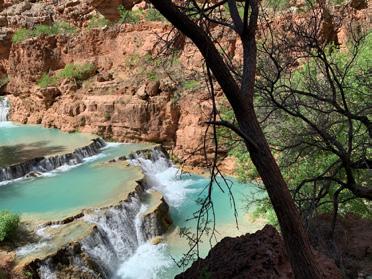
Dissolution of calcium carbonate minerals, such as that which must have occurred under the sinkhole of Figure 1-2, results in calcium carbonate-saturated fluids such as the turquoise blue, spring-fed waters of the Little Colorado River (Fig. 1-4). At its confluence with the Colorado River and weather permitting, one can witness mixing of these blue waters with red, mud-rich waters of the Colorado (Spanish for “colored red”) River.
Calcium-carbonate-saturated springs manifest themselves as travertine deposits, including those coating boulders and forming terraces in Figure 1-4, and as travertine-cemented talus and river gravels. Travertine can be dated with sufficient precision to calculate rates of river downcutting (Section 6) and, hence, contribute to our understanding of the evolution of the Colorado River and the nature and age of Grand Canyon’s formation.
From this important boundary in geologic time, the Permo-Triassic Unconformity, we move on to some other boundaries, including those impacting permeability and hydrology.
2. ECONOMIC GEOLOGY, HYDROLOGY AND PLUMBING SYSTEMS (RM 1-11.7)
Resource exploration and development depends on an understanding of porosity, permeability and fluid flow. The Grand Canyon represents an unparalleled outdoor laboratory in which to view an in-situ “plumbing system” prior to it being overprinted by a mineralizing or petroleum system. Understanding
the Grand Canyon’s plumbing system begins with understanding its groundwater system, including its aquifers and faults (Fig. 2-1; Crossey and Karlstrom, 2012). In the Figure 2-1 schematic, regional, surface-derived waters (“Upper World Waters”) flow via aquifers and structures from the San Francisco Peaks recharge area (near Flagstaff, AZ) towards the north and northwest. These waters mix with “Lower World Waters” supplied by deep-seated faults. Water exit points (springs) are typically controlled by permeability barriers and structural conduits. Keep this schematic in mind, as many aspects of the sections herein and their interconnectivity can be linked to details in this figure.
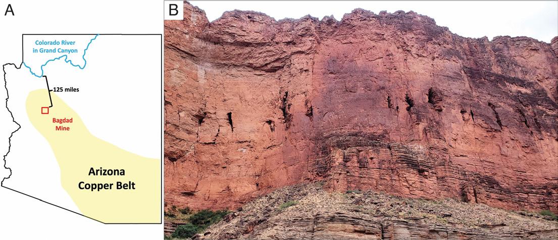
The unparalleled natural laboratory Grand Canyon represents is exemplified by Figure 2-2A. The Grand Canyon lies north of the northwestern extension of the Arizona Copper Belt and only 125 miles north of the Bagdad Mine. The Bagdad Mine is a porphyry copper deposit containing one of the largest copper reserves in the world. Porphyry copper systems can be complex and consist of many different deposit types including porphyry, skarn, carbonate-replacement, sediment-hosted, meso- and epithermal vein types and breccia pipes. One can’t overstate the value of being able to examine a host system and its “grand” plumbing system before it is overprinted and altered by either a complex Bagdad-like mineral system, or by a petroleum system, such as that associated with the organic-rich, immature source rocks present within the Proterozoic Group II rocks of the Grand Canyon (Fig. 0-4).
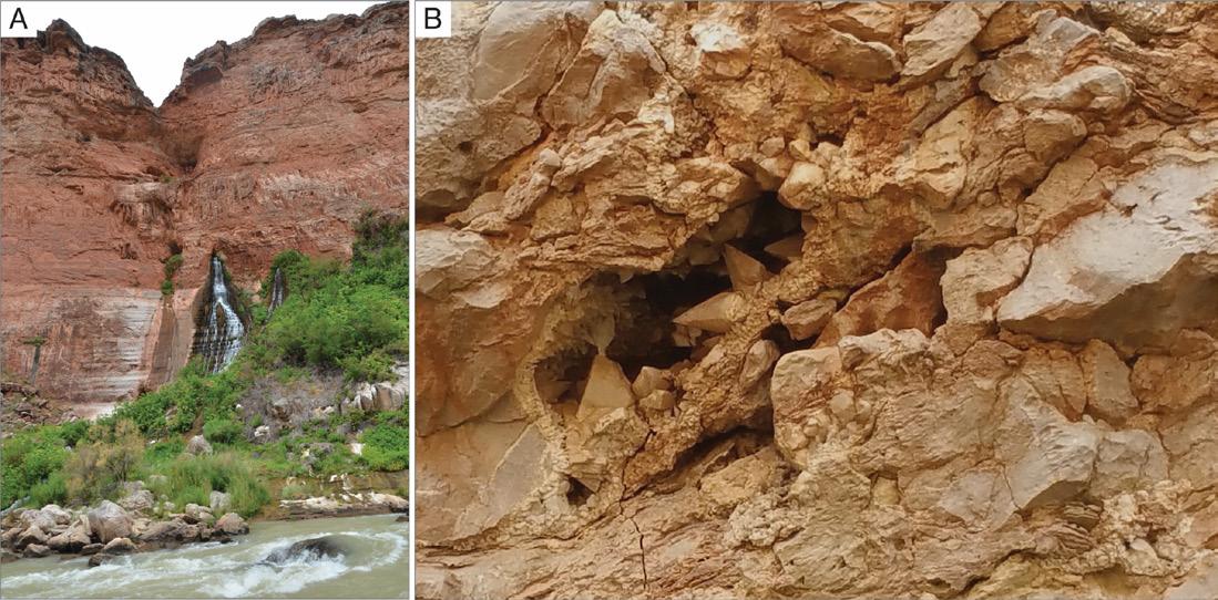
The plumbing system in the Grand Canyon is largely the product of carbonate rock dissolution and karstification. Stratigraphic and structural controls on dissolution abound (Fig. 2-2B) and the resulting caves can be: inactive and empty (Fig. 2-2B); conduits for springs, such as those at Vasey’s Paradise (Fig. 2-3A); or filled with highly porous and permeable cave-fill breccias and speleothems, such as dogtooth calcite (Fig. 2-3B). Progressive upward roof collapse in caves (Fig. 2-4A) can ultimately lead to the development of breccia pipes (Fig. 2-4B), which then can be exploited by mineral- rich solutions. Over 1000 breccia pipes have been mapped in the Grand Canyon area, many having element
Vol. 73, No. 4 | www.rmag.org 23 OUTCROP | April 2024
LEAD STORY
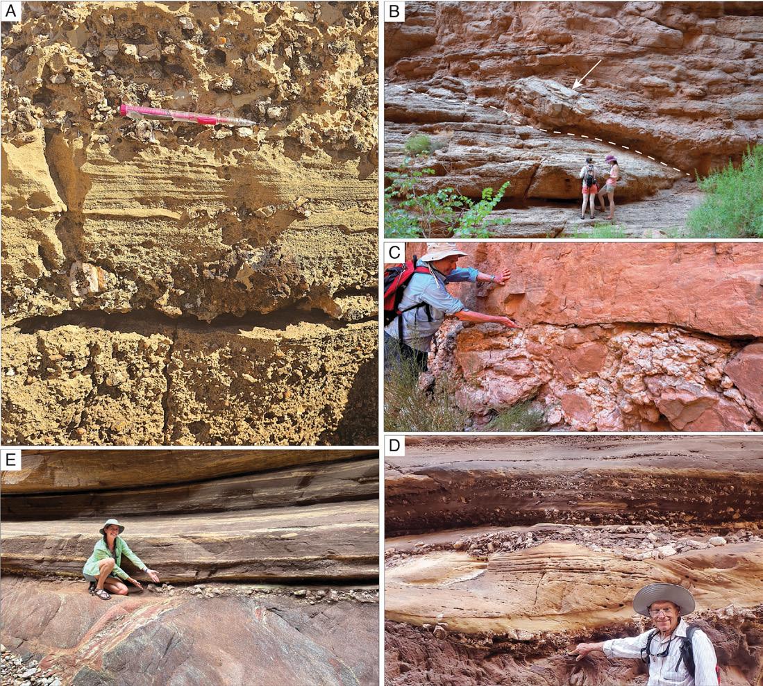
1-3: A. Basal conglomeratic sediments of the Triassic Moenkopi Fm immediately above the Permo-Triassic Boundary, and exposed at the House Rock Valley Overlook on US Hwy 89A, approximately 24 miles (40 km), as the crow flies, west-southwest of Marble Canyon, Arizona. This location is on top of the Kaibab Monocline, which is the northwesterly manifestation of the Butte Fault, a classic reactivated fault that may have controlled sedimentation and the location of Moenkopi Fm gravels (Wade, 2024 pers. comm.). B. Conglomeratic basal contact (dashed line) of a Devonian Temple Butte Fm incised-valley system with up to 6 ft (2 m) long boulders (arrow) (near RM 38). C. Conglomeratic contact between the Temple Butte Fm and overlying Mississippian Redwall Limestone (near RM 38). D and E. Basal conglomeratic sediments of the Cambrian Tapeats Sandstone immediately above the Vishnu Schist at the spectacular Great Unconformity (author M. Marshall pointing in E) in Blacktail Canyon of Grand Canyon (RMR 120.7). Approximately 1.2 billion years of missing time is represented by the unconformity at this locale. (Photo in D courtesy of Montana Hodges.)
OUTCROP | April 2024 24 Vol. 73, No. 4 | www.rmag.org LEAD STORY
FIGURE
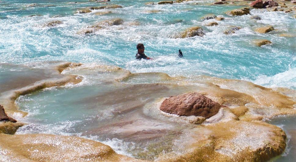
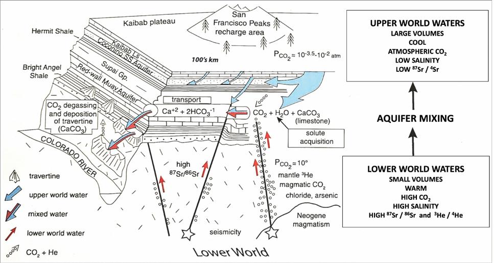
FIGURE 2-1: Schematic
Blue arrows represent water recharged by precipitation
the
and infiltrating
Coconino and Redwall-Muav aquifers. Red arrows represent deeply circulated waters and gases rising along faults and mingling with existing groundwaters. Large boxes highlight characteristics of “lower world” and “upper world” waters; small boxes along groundwater flow paths indicate regions of solute acquisition, transport, and deposition. Figure and caption after Crossey and Karlstrom, 2012.
Vol. 73, No. 4 | www.rmag.org 25 OUTCROP | April 2024 LEAD STORY
FIGURE 1-4: Warm, calcium-carbonate-saturated, spring-sourced waters of the Little Colorado River. Water turbulence here helps catalyze precipitation of calcium carbonate (travertine) as terraces, boulder coatings and white shoreline muds.
model for spring and travertine formation on the Colorado Plateau (including Grand Canyon).
on
surface
into the
OUTCROP | April 2024 26 Vol. 73, No. 4 | www.rmag.org LEAD STORY
FIGURE 2-2: A. Grand Canyon relative to the Arizona Copper Belt and the Bagdad porphyry copper mine. B. Cavernous dissolution porosity within the Redwall Limestone, showing both stratigraphic and structural control.
FIGURE 2-3: A. Vasey’s Paradise where seasonally-influenced springs emanate from a cave system in the Redwall Limestone (RMR 32.1). B. Cave-fill breccia with remnant primary porosity partly filled with speleothem, including dog-tooth calcite crystals (RMR 35). Largest crystals are about 6 inches (15 cm) in length.


Vol. 73, No. 4 | www.rmag.org 27 OUTCROP | April 2024 2 5 0 1 S h e r i d a n B l v d E d g e w a t e r , C O 8 0 2 1 4 C O M E F O R H A P P Y H O U R ! RMAG & DWLS HAPPY HOUR Join fellow local geoscientists for Happy Hour T H U R S D A Y A P R I L 2 5 , 2 0 2 4 4 T O 6 P M J O Y R I D E B R E W I N G RSVP www.rmag.org/happyhour F i r s t 1 5 A t t e n d e e s w i l l g e t a f r e e b e e r !
enrichments of U, Cu, Ag, Pb, Zn, Mo, Ni, Co, V, As, Ba, Co, Fe, S, and even REEs (Sutphin and Wenrich, 1989; Wenrich, pers. comm., March, 2024). Their surface expression includes features like the collapse structure previously shown in Figure 1-2. These and other dissolution- related features are frequently related to unconformities that bound stratigraphic sequences, which are the topic of our next session.
3. SEQUENCE STRATIGRAPHY AND CYCLICITY (RM 11.7-37.8)
Our river journey provided opportunities to observe stratigraphic cycles and sequences at multiple spatial and temporal scales, from the regional (e.g., Grand Canyon Supergroup) to the local (e.g., Bass Fm 5-ft-thick upward-shoaling stromatolite cycles). The hierarchy of stratigraphic sequences encountered in the Grand Canyon is better understood
within the context of the mega-regional “three packages of rocks” (Groups I, II and III; Fig. 0-4) initially sketched by John Wesley Powell in 1875, and representing almost two billion years of tectono-stratigraphic history. Abbott (2001) recognized that these seismic-scale rock packages correspond to three 1st-order stratigraphic sequences—I) the Early Proterozoic basement schists and granites, II) the Middle and Late Proterozoic Grand Canyon Supergroup and III) the “layered rocks” of the Paleozoic section (Figs. 0-4 and 3-1)
Stratigraphic sequences are delineated laterally via their internal geometries and bounding unconformities defined by onlapping, offlapping or erosionally-truncated strata. Vertically, successions of sedimentary facies show alternating deepening and shallowing depositional conditions through time. This transgressive and regressive cyclicity exists in a hierarchy (Fig. 3-1) resulting from different
OUTCROP | April 2024 28 Vol. 73, No. 4 | www.rmag.org
LEAD STORY
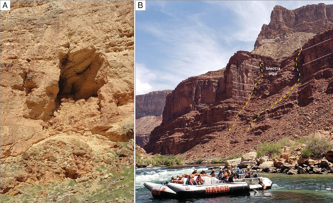
FIGURE 2-4: A. Cave with upward-stoping roof collapse and brecciation in the Redwall Limestone (RML 35.7). Cave width is ~30 ft (9 m). B. Breccia pipe (RML 22.8) developed in Supai Group sandstones and mudstones that likely overlie cave collapse in the immediately underlying and buried Redwall Limestone.
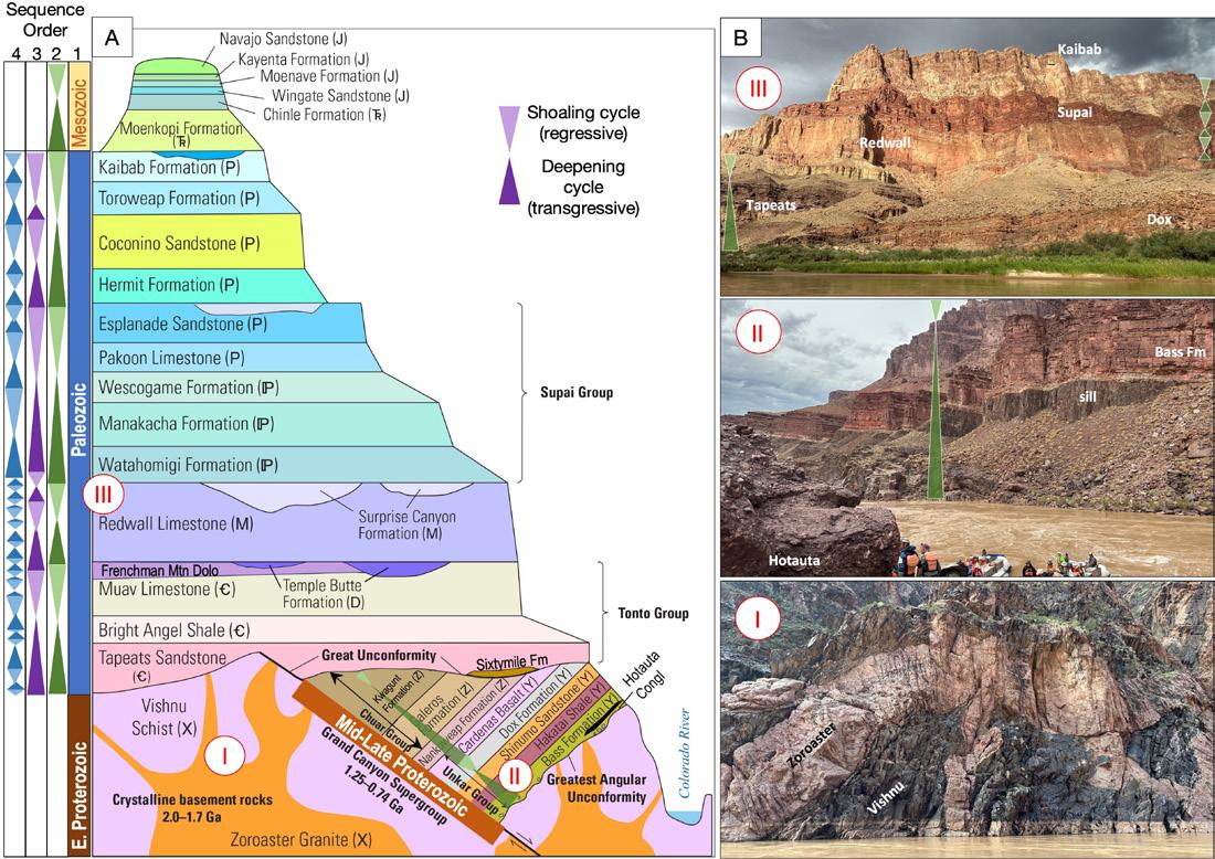
FIGURE 3-1: A. General stratigraphic column encountered in the Grand Canyon along the Colorado River. First-order sequences correspond to the same three major stratigraphic units (Groups) shown in Figure 0-4.
Multiple scales (orders) of transgressive (deepening)-regressive (shoaling) cycles are depicted in the Sequence Order columns, and represent variable rock thicknesses and time spans. This hierarchy of 1st (Eras), 2nd (green triangles), 3rd (purple triangles), and 4th-order (blue triangles) stratigraphic cycles in the Grand Canyon was initially interpreted by Abbott (2001) and is expanded and revised by Connors et al. (2020) and current authors. Abbott (2001) considered the Paleozoic, Mesozoic, Early Proterozoic and Middle + Late Proterozoic as each corresponding to a 1st-order sequence, geologic Groups (e.g., Unkar, Chuar, Tonto, Supai of Figure 0-4, and distinct from Groups I - IV) as corresponding to 2nd-order sequences, and Formations comprising 3rd-order sequences. Higher-resolution 4th and 5th-order cycles were observed and interpreted by the current authors at various points in the Canyon (see other Section 3 figures). Figure adapted from Connors et al. (2020, their Fig. 3-1) and Abbott (2001, his Fig. 1). B. Beginning with the lower photo, Group I basement Vishnu Schist and Zoroaster Granite at RM 100.5 between Tuna and Agate rapids; middle photo Group II Hotauta Conglomerate in foreground (by raft) overlain by diabase sill, then the foreground cliff-forming reddish Bass Fm, slope-forming Hakatai Shale and cliff-forming Shinumo Sandstone, below Hance Rapid (RM 77.5); upper photo Group III rocks showing basal contact with Group II Proterozoic Dox Fm at river level overlain by Group III Paleozoic layered rocks, the Tapeats Sandstone through Permian Kaibab Limestone at RML 66 (Lava Canyon/Chuar Rapid).
Vol. 73, No. 4 | www.rmag.org 29 OUTCROP | April 2024 LEAD STORY
frequencies or time spans (orders) of relative sealevel fluctuations. Abbott (2001) used both the seismic-scale geometries and the small-scale vertical cyclicity visible throughout the Canyon to discern several scales of stratigraphic sequences. He interpreted the Grand Canyon’s Paleozoic, Mesozoic, Early Proterozoic and Middle + Late Proterozoic as each comprising a 1st-order sequence; geologic Groups as 2nd-order sequences;, and Formations as 3rd-order sequences (Fig. 3-1). Geologic Groups including the Unkar, Chuar, Tonto, and Supai groups are distinct from the four major Grand Canyon rock groups (see Fig. 0-4A for this distinction). From river level and on side-canyon hikes, we observed vertical cyclicity at 2nd-, 3rd-, 4th-order and higher scales along with their internal sedimentological features. Sequence boundaries are commonly characterized
by exposure, dissolution and karstification, especially in carbonate-dominated successions. We encountered world-class exposures of many of these features, which were discussed in Section 2 (Figs. 2-3, 2-4, 2-5)
Examples of 2nd-order sequences viewable from the river are found in the Proterozoic Unkar and Chuar Groups. Portions of the lower sequence (Unkar Group in Fig. 3-1, photo of Group II rocks) may be seen below Hance Rapid (RM 77.5). Here the basal Hotauta Conglomerate is in the foreground (by the raft) and is overlain by a diabase sill and then by the Bass Formation, the reddish cliff in the foreground, which in turn is overlain by the slope-forming Hakatai Shale and cliffy Shinumo Sandstone (Fig. 3-1).
After putting in at Lees Ferry and immediately
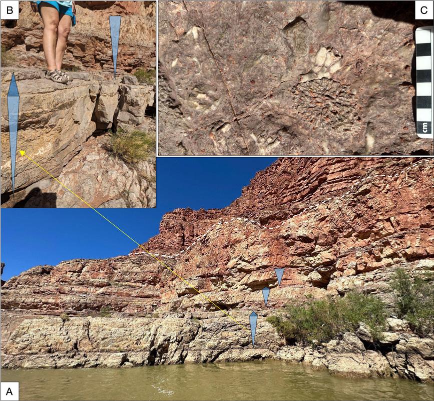
FIGURE 3-2: A. Mississippian Redwall ~4 ft (1.3 m)-thick, 4thorder transgressiveregressive (T-R) dolostone cycles at Fossil Bench (RMR 24.8). Undulatory top of Redwall (white dashed line) shows dissolutionenhanced fracture and collapse. B. Close-up of two 4th-order shoaling cycles (size 7.5 shoe = 10 inches). C. Skeletal debris including horn and finger corals on Fossil Bench bedding plane at top of one cycle.
OUTCROP | April 2024 30 Vol. 73, No. 4 | www.rmag.org
LEAD STORY
encountering our first unconformity—the Permo-Triassic unconformity discussed in Section 1— we proceeded down river as well as down section through progressively older Paleozoic rocks. We emerged from the base of the Supai Group to continue cutting down section to the top of the Mississippian Redwall Limestone at RM 23.2, where the Surprise Canyon Formation fills incised valleys of the karstified unconformity surface at the top of the Redwall. Continuing past another mile or so of magnificent Mississippian Redwall cliffs, we encountered the “Fossil Bench” at RMR 24.8. The ‘Bench’ comprises a Redwall bedding plane cap of one of several 4th-order shoaling cycles (Fig. 3-2). Each approximately 3-ftthick (1-m) cycle begins in basal thin, wavy-bedded dolomitic mudstone and packstone and then shallows upward to grainstone and packstone containing chert nodule horizons. Cycles are commonly ‘capped’ by skeletal grainstone containing horn corals, finger corals, brachiopods and bryozoans (Fig. 3-2). The Redwall is prone to dissolution and karsting as discussed in Section 2, which contribute to the formation of many alcoves and caverns along this stretch of the river, possibly including the spectacular Redwall
FIGURE 3-3: Tapeats Sandstone transgressively onlaps Vishnu Schist ‘island’ at the Great Unconformity (white dashed line), a 3rdorder sequence boundary at RMR 120.6. A 3rd-order (purple triangle) deepening succession occurs in the Tapeats Sandstone, with maximum flooding occurring in the overlying, slopeforming Bright Angel Shale. Higher resolution, likely 4th-order (blue triangles) depositional T-R cycles occur within the Tapeats Sandstone. Group III layered Paleozoic rocks fill the background to the skyline.
Cavern ( RM 33.3.)
We observed an excellent exposure of the Great Unconformity, a 3rd-order sequence boundary at RMR 120.6, where the Cambrian Tapeats Sandstone onlaps the Vishnu Schist and exhibits shoreface-to-tidal zone facies within shallowing 4th-order cycles (Fig. 3-3). We previously hiked to another extraordinary exposure of the Great Unconformity in Blacktail Canyon at RMR 120.7 (Fig. 1-3E). The Tapeats Sandstone is one of the vast “sand seas” of the Sauk sequence (Sloss, 1963), and results from the marine transgression of the Cambrian sea over widespread areas of the North American Laurentian craton. This exposure offered a singular stratigraphic thrill to those of us unused to witnessing stratigraphy at three+ scales in a single outcrop!
Tapeats Creek at RMR 134.4 rewarded hikers with close-up encounters with 4th-order dolostone shoaling cycles of the Bass Formation. These 3-6 ft-thick (1-2 m) cycles consist of basal mudstone/dolostone and shoal upward into algal-laminated stromatolites (Fig. 3-4) containing trapped debris, siliciclastic grains and mud cracks on bedding planes. The stromatolitic texture varies from
Vol. 73, No. 4 | www.rmag.org 31 OUTCROP | April 2024
LEAD STORY
OUTCROP | April 2024 32 Vol. 73, No. 4 | www.rmag.org LEAD STORY
FIGURE 3-4: A. Bass Formation dolostone stromatolite-capped 4th-order T-R cycles above the Colorado River (RMR 134.4) along Tapeats Creek trail. Several Bass Fm shoaling cycles (blue triangles) are noted on the opposite canyon wall and may be traced throughout the canyon. Light-blue upward shoaling triangle is approximately 5 ft (1.5 m). B. Enlargement of stromatolitedominated facies in caps of shoaling cycles. Vertical span of photo is approximately 2.5 ft (0.75 m).
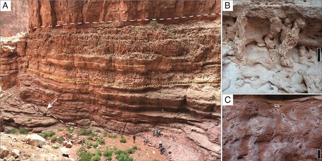
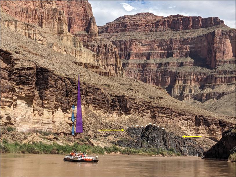
FIGURE 4-1: A. Exceptional exposure of an 80-ft-thick (25 m) Temple Butte Fm incised-valley system near Tatahatso Wash (near RM 38) (white lines demarcate the upper and lower contacts; yellow line marks the transition between dominant facies; arrow indicates same boulder as in Figure 1-3B; photo courtesy of Neil Sharp). B. Well-cemented columnar root traces of the upper half of the TB; the top bed in this image is a 15-inches (40-cm)-thick carbonate gravel bed (scale bar is 10 inches (25 cm)). C. Paleosol with root traces with reduction haloes common in the basal half of the TB (scale bar is 10 inches (25 cm)).
wavy-laminated to faintly columnar. Each stromatolite cycle is overlain abruptly by mudstone, which likely represents drowning events that terminated stromatolite growth. This high-resolution alternation of small-scale shoaling and deepening repeats for at least 10 cycles and may be traced laterally across and up and down the Tapeats Creek canyon walls (Fig. 3-4A)
4. TEMPLE BUTTE FORMATION INCISED-VALLEY SYSTEMS AND ROOT TRACES (RM 37.8-52.5)
Our trip also included research into the Devonian Temple Butte Formation (TB) that engaged both geologists and geology-interested rafters. This compelling unit hosts traces of some of the earliest forests on Earth, though access is elusive in most areas of the Grand Canyon. Our team collected data from an excellent exposure of TB, where a typically inaccessible cliff exposure was carved by an ephemeral
waterfall that provided access from the TB base up to the Mississippian Redwall Limestone (Fig. 4-1A)
The TB in Marble Canyon records a stream network incised into the Cambrian Frenchman Mountain Dolostone or Muav Limestone (Fig. 1-3B; Beus 1990; Rowland et al., 2023). Eroded valleys later filled transgressively with mostly nonmarine deposits. The TB is sharply overlain by the Redwall Limestone, with a 3-ft-thick (1 m) conglomerate at the contact (Fig. 1-3C). The valleys are steep-walled and flat-topped, with sediment infill as much as 80 ft (25 m) thick (Fig. 4-2). The apparent widths of TB valleys vary with the angle at which the exposure is cut, ranging up to at least 400 ft (120 m) of lateral exposure (Fig. 4-2). Multiple examples of transverse exposures of the valleys and their fill occur on both sides of the Colorado River, beginning near Tatahatso Wash (RML 37.8), and continuing downstream; they remain prominent on the cliff faces through at least RM 52. River runners can spot the Temple Butte as soft-weathering lenses at the base of the Redwall
Vol. 73, No. 4 | www.rmag.org 33 OUTCROP | April 2024
LEAD STORY
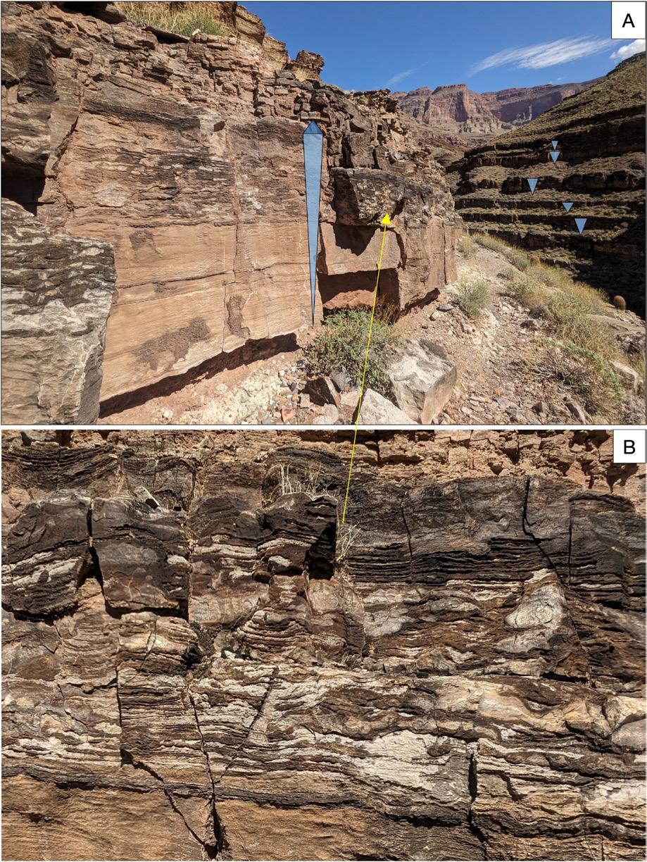
4-2: A.
41.7),
entrance to an alcove. B. TB exposure near RML 43.8, highlighting the purple paleosols
lower
and pale
carbonates of the upper half; faint columnar features throughout are root traces (fill estimated to be 50-60 ft (15-18 m) thick). C. Three adjacent TB incised-valley systems are exposed along the cliff face on the upstream wall of Saddle Canyon (RMR 47.4), suggesting meanders; these fills are all estimated to be 35-45 ft (11-14 m) thick, incised to similar depths. D. The left-most complete TB fill exposed at Saddle Canyon in C (RMR 47.4); note the irregularity of the basal contact. White lines mark upper and lower TB contacts in A-D.
with purple bases and light gray tops (Fig. 4-2B). Several instances of multiple, closely spaced TB incised-valley systems suggest either meanders or multiple semi-parallel valleys (Fig. 4-2C).
The TB hosts 3-6-ft-thick (1-2 m) cyclic sedimentary packages (likely 4th-order cycles). The lower half of each incised-valley fill has interbeds of distinctive purple-red paleosols with light gray root traces (Fig. 4-1C) and ~1-3-ft (0.5-1-m)-thick lenses or beds filled with carbonate gravel, which we interpret as high-gradient stream deposits. Beds of the upper half are light grayish-tan and host abundant
calcified columnar root traces (Fig. 4-1B). Root traces can be as much as ~3 ft (1 m) long and up to 4 inches (10 cm) in diameter, some with associated caliche nodules. Root traces are attributed to large progymnosperms—tall, spore-producing trees of the mid-Paleozoic (e.g., Algeo and Scheckler, 1998).
The TB hosts some of the earliest forests in western North America, and these deposits record a key interval of non-marine deposition in the otherwise marine-dominated Paleozoic succession (Marshall and Warme, in prep).
Many TB exposures are evident within alcoves
OUTCROP | April 2024 34 Vol. 73, No. 4 | www.rmag.org
LEAD STORY
FIGURE
Three-dimensional exposure of the TB at Royal Arches (RMR
perched atop the Cambrian carbonates at the
of the
half
gray
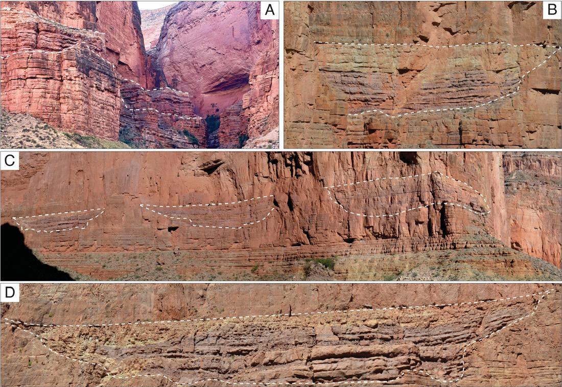
or on perched ledges (Fig. 4-2A), likely due to the less resistant nature of the muddy paleosols compared to the overlying cliff-forming carbonate units. The TB becomes thicker and more laterally continuous towards the paleo-shoreline to the west and is the slope-forming unit between the cliff-forming, thin-bedded Frenchman Mountain Dolostone and thick-bedded Redwall Limestone. Although inaccessible, notable TB exposures are visible from the river downstream at Palisades of the Desert (RML 65.9), across from Matkatamiba Canyon (RMR 148.4), at Havasu Creek (RM 157-158) and at Fern Glen Canyon (RMR 168.5) (also see Rowland et al., 1995; Rowland et al., 2023).
Finally, about halfway up the river-right cliff across from the Whitmore Helipad at RM 187.4, there is a laterally extensive, relatively thin, dark purple exposure of the Temple Butte Formation. This is about 76 miles (122 km) directly west of the first TB exposure we encountered. Just before our helicopter rose over the Rim, we caught one last glimpse of
these Devonian deposits that supported soils and large-scale forests farther east and left behind columnar root structures. We also spied another distinctive columnar feature up- and downstream in the much more recently incised valleys filled with columnar basalts (Section 8). Stay tuned for next month’s issue for more on those features.
NEXT MONTH, IN PART 2:
We encounter the Nankoweap outwash delta and Ancestral Puebloan granaries, learn how travertine dating helps decipher incision rates and age of the Grand Canyon, and observe the ongoing forces (landslides! lava dams!) that assist the Colorado River as it carves its future course.
ACKNOWLEDGMENTS
• We gratefully acknowledge the following:
• Our fellow river-runners for their enthusiasm, participation, and cheerful spirits of cooperation, learning and fun.
Vol. 73, No. 4 | www.rmag.org 35 OUTCROP | April 2024
LEAD STORY Gain valuable inter well insight s Premature breakthrough of injected water, steam, gas or CO2 can limit oil production. At minimal cost, chemical tracers can rapidly detect and quantify reservoir flow heterogeneities so remediation or flood rebalance can be made to maximize well productivity. t r acer co.com @ t r acer co t r acer co @ t r acer co.com
t reducing your cost
Star
s
• John Warme, who originally planned to be along on this trip and who has sparked so many research directions—and who was with us day in and day out in spirit—for his experience (50+ times downriver!), knowledge, enthusiasm and encouragement.
• Steve Hatch and Hatch River Expeditions—in particular, super-guides Eric Deitemeyer, Mariah Giardina, and Caleb Dusek—for superb, successful planning and execution of a most excellent Colorado River adventure. Your expertise and experience, wisdom and wit are second to none.
• Bill Wade for his knowledgeable teamwork and geo-narration.
• The U.S. National Park Service for a research permit and supporting continued research in the Grand Canyon (permit GRCA-2023-SCI-0057 of M. Marshall for field work on the Temple Butte Formation).
• Co-author and inspiring geo-guide, Lew Kleinhans, who planned and executed the trip with Hatch. Your wisdom, geologic knowledge of the Grand Canyon and boundless energy made this trip
‘formidable,’ even in the absence of live oysters!
• Unless otherwise noted, photographs are those of the authors.
REFERENCES
Abbott, W., 2001, Revisiting the Grand Canyon –Through the Eyes of Seismic Sequence Stratigraphy. AAPG Search and Discovery Article #40018. Algeo, T. J. and S.E. Scheckler, 1998, Terrestrial-marine teleconnections in the Devonian: links between the evolution of land plants, weathering processes, and marine anoxic events. Philosophical Transactions of the Royal Society of London. Series B: Biological Sciences, 353(1365), 113-130.
Belknap, Buzz and L. B. Evans, 2023, Waterproof Grand Canyon River Guide, Expanded Edition, WestwaterBooks.com, P.O. Box 2560, Evergreen, CO, 80437.
Beus, S.S., 1990, Temple Butte Formation. In: Beus, S.S., Morales, M., eds., Grand Canyon Geology, Oxford University Press, New York, 107-117.

Blakey, R.C. and W. Ranney, 2008, Ancient landscapes of the Colorado Plateau. Grand Canyon Association. Connors, T.B., Tweet, J.S., and V.L. Santucci, 2020, Stratigraphy of Grand Canyon National Park, in Santucci and Tweet, eds., Grand Canyon National Park - Centennial Paleontological Resource Inventory, Natural Resource Report NPS/ GRCA/NRR—2020/2103, Ch. 3, 34 p. Crossey, L.J. and K.E. Karlstrom, 2012, Travertines and travertine springs in eastern Grand Canyon: What they tell us about groundwater, paleoclimate, and incision of Grand Canyon. Geol Soc Am Spec Pap, 489, 131-143.
Dal Corso, J., Song, H., Callegaro, S., Chu, D., Sun, Y., Hilton, J., Grasby, S.E., Joachimski, M.M., and P.B. Wignall, 2022, Environmental crises at the Permian–Triassic mass extinction. Nature Reviews Earth & Environment, 3(3), 197-214.
Elston, D.P., Billingsley, G.H., and R.A.
OUTCROP | April 2024 36 Vol. 73, No. 4 | www.rmag.org
LEAD STORY
Young, eds., 1989, Geology of Grand Canyon, Northern Arizona (with Colorado River Guides): Lees Ferry to Pierce Ferry, Arizona: American Geophysical Union Field Trip Guidebook T115/ T315, 240 p.
Esri, TomTom, Garmin, FAO, NOAA, USGS, Bureau of Land Management, EPA, NPS, USFWS. “Terrain with Labels” [basemap]. 1:1,400,000. “World Terrain Base”. May 27, 2020. https://ac-gis.maps. arcgis.com/apps/mapviewer/index.html?webmap=d874707bcc1846a6a7fc7eb1ba24a629. (February 17, 2024).
Google Earth. V 7.3.6.9750. (July 2, 2019) Sinkhole above Tanner Wash, Marble Platform, Arizona. 36.675965° -111.682977°, Eye alt. 1178 feet. [February 20, 2024].
Karlstrom, K., Crossey, L., Mathis, A., and C. Bowman, 2021, Telling time at Grand Canyon National Park: 2020 update. Natural Resource Report NPS/GRCA/NRR—2021/2246. National Park Service, Fort Collins, Colorado, 36 p.
Karlstrom , K., Hagadorn , J., Gehrels , G., Matthews , W., Schmitz , M., Madronich , L., Mulder, J., Pecha , M., Giesler, D., and L. Crossey, 2018, Cambrian Sauk transgression in the Grand Canyon region redefined by detrital zircons, Nature Geoscience , 11, 438-443.
Kwiatkowski, C., 2021, Influence of the Permo-Triassic Cordilleran arc on Early to Middle Triassic deposystems, Mojave and Sonoran Deserts. Masters thesis, Northern Arizona University.
Marshall M.S., and J.E. Warme, 2022, Incised valley depositional sequence and root traces of the Late Devonian (Frasnian) Temple Butte
Formation in Marble Canyon, Eastern Grand Canyon. Geological Society of America Abstracts with Programs, 54(5), doi: 10.1130/ abs/2022AM-379532.
Marshall, M.S., and J.E. Warme, in prep, Incised valley depositional sequence and root traces of the Late Devonian (Frasnian) Temple Butte Formation in Marble Canyon, Eastern Grand Canyon.
Pipiringos, G.N. and R.B. O’Sullivan, 1978, Principal unconformities in Triassic and Jurassic rocks, western interior United States; a preliminary survey. USGS Professional Paper 1035A.
Rowland, S.M., Osborn, G.D., Graber, D.J., and S.M. Rowland, 1995, Lower Paleozoic Stratigraphy of Fern Glen Canyon, Central Grand Canyon, Arizona. Journal of the Arizona-Nevada Academy of Science, 28(1/2), 1-11.
Rowland, S.M., Korolev, S., Hagadorn, J.W., and K. Ghosh, 2023, Frenchman Mountain Dolostone: A new formation of the Cambrian Tonto Group, Grand Canyon and Basin and Range, USA. Geosphere, 19(3), 719-747.
Sloss, L.L., 1963, Sequences in the Cratonic Interior of North America. Geological Society of America Bulletin. 74(2): 93.
Sutphin, H.B. and Wenrich, K.J., 1989, Map of locations of collapse-breccia pipes in the Grand Canyon region of Arizona: U.S. Geological Survey Open-File Report 89-550, 1 plate with text, 1:250,000.
Warme, J.E., 2004, Poncho’s Radical Runup: Unusual ancient Grand Canyon landslide, Colorado River, Arizona. In Geological Society of America, Abstracts with Programs, 36(5) p. 551.
OUTCROP | April 2024 38 Vol. 73, No. 4 | www.rmag.org
LEAD STORY Well Log Digitizing • Petrophysics Petra® Projects • Mud Log Evaluation Bill Donovan Geologist • Petroleum Engineer • PE (720) 351-7470 donovan@petroleum-eng.com
Speaker: Karen Lechtenberg
Date: April 3, 2024 | 12:00 pm - 1:00 pm

Navigating the CCUS Journey
Lessons Learned from Project Scoping to Class VI Permit Submission
Presenter: Karen Lechtenberg, Carbon America
Carbon Capture, Utilization, and Storage (CCUS) represents an emerging industry that leverages on the existing expertise of geoscientists in subsurface characterization and evaluation. These projects offer a promising solution to mitigate emissions across various industries. However, the journey from project inception to regulatory approval, especially regarding Class VI permit construction and submission, presents numerous challenges
Karen Lechtenberg serves as the Director of Geoscience at Carbon America, a leading Carbon Capture and Sequestration company based in Colorado. With a decade of experience in drilling operations and reservoir characterization, she brings a comprehensive and versatile skill set to the subsurface team. Prior to her role at Carbon America, Lechtenberg held geology positions at Ovintiv (previously Encana), where she focused on projects in the Rocky Mountain and West Texas regions.
and complexities owing to the unique nature of each project and the novelty of the process. This presentation discusses the evaluation of CCUS project sites, drawing upon the valuable experience gained from a DJ Basin Region 8 project, alongside insights from similar projects nationwide. It will explore lessons learned throughout the phases of project scoping, detailing the nuanced intricacies encountered during Class VI permit submission.
In her role at Carbon America, Lechtenberg has been instrumental in designing and leading a multidisciplinary team for the execution of stratigraphic science well programs. Her expertise extends to the integration of collected data into 3D geocellular models and injection simulations, ensuring compliance with EPA Class VI requirements. Notable achievements include her role in Carbon America’s first stratigraphic well, culminating in the submission of the inaugural Class VI permit in EPA Region 8 and Colorado. In collaboration with the Colorado School of
Mines and Los Alamos National Lab, the Carbon America team is also executing a $32.6 Million CarbonSAFE grant in southern Colorado.
Lechtenberg holds a Bachelor of Science and a Master of Science in Geology from the University of Kansas. Her academic specialization lies in carbonate sequence stratigraphy, highlighted by her research on the Build-and-Fill Geometries of the Lower Ismay (Pennsylvanian) Carbonates in the Paradox Basin, Utah, USA.
OUTCROP | April 2024 40 Vol. 73, No. 4 | www.rmag.org HYBRID LUNCH TALK
 By Anton F.-J. Wroblewski and Bonnie E. Gulas-Wroblewski
Vol. 73, No. 4 | www.rmag.org 41 OUTCROP | April 2024
Congratulations to: Best Outcrop Article of 2023
STORIES FROM THE SEASHORE EXPLORING a 59-MILLION-YEAR-OLD COAST ON WYOMING’S HIGH PLAINS Featured in the June 2023 Issue:
Speaker: Sarah Compton
Date: May 1, 2024 | 12:00 pm - 1:00 pm
Using the Relationship Between Geochemical and Pressure Data to Elucidate Produced Oil Sources and Movement in the Subsurface
Presenter: Sarah Compton, Compton Integrated Analytics
Understanding how and why fluids move in the subsurface is key to characterizing and most efficiently developing an operator’s acreage. In the DJ Basin, oil from the Niobrara and Codell likely has a common source, and their reservoirs are likely in communication with each other. Great Western Petroleum, a pure-play DJ operator, designed the Wilson project in 2019 through a structurally calm area, with one large graben cutting the full section along the toes
SARAH COMPTON is the Principal at Compton Integrated Analytics, a consultancy based in Morrison, Colorado. With over a decade of combined experience across product management, geoscience, and data analytics, she brings a broad base of expertise. Her most recent role in product management brought her further into the business and product side of the industry. Her work with a start-up client as well as geology roles at Great Western Petroleum

of the wells, to characterize fluid movement in space and time. In 2020, data from eight parent wells on the nearby Postle pad was added. This pad is characterized by several faults cutting the full section at various spots along the lateral. The case studies show differences in fluid communication despite similar completion methods, perhaps relating to different structural settings.
and Noble Energy (now both a part of Chevron) gave her experience across the full life cycle of a well, starting with exploration, on to permitting, going through drilling, and followed up with post-drill analytics and regulatory submission. Her work with industry vendors and analyses throughout her career has given her experience in data collection, cleaning, structuring, and analysis, including crash courses in the programming tools required to go beyond Excel, which is inevitably always required.
Her work at Compton Integrated Analytics has delivered high value products to her clients on time and within budget. She completed an NSF iCorps Starting Blocks cohort last spring and was invited to present her business proposition for a SAGE mentorship group, which she was awarded and is currently working with.
Sarah earned her PhD in geology from the University of Alabama, using linear inversions to focus on the impacts of different model setups of finite element models using Hekla Volcano in Iceland. Her MS and BS in geology were earned at IUPUI focusing on the crustal evolution of southern and southeastern California using igneous petrology.
OUTCROP | April 2024 42 Vol. 73, No. 4 | www.rmag.org HYBRID LUNCH TALK
CONSIDER PUBLISHING IN THE

We invite you to contribute to the vibrant and dynamic Outcrop, where your geological discoveries can find a home among like-minded professionals. Whether you have a compelling geological story, ground breaking research, insightful book reviews, or something else looking for it’s geologic home, the Outcrop is the ideal space to share your expertise with the geological community. Our publication process ensures a swift transition from submission to publication, allowing your work to reach a global audience in a timely manner. Additionally, every published lead article is entered to win the Outcrop article of the year, and entered to win a free RMAG field trip. Join us in fostering knowledge exchange and advancing the field of geology by considering The Outcrop as the premier outlet for your valuable contributions. Contact the outcrop Editor Nate La Fontaine
Vol. 73, No. 4 | 43 OUTCROP
with your submission at nlafontaine@sm-energy.com
The Mountain Geologist Best Paper Award for 2023
The Rocky Mountain Association of Geologists is pleased to announce the winner of The Mountain Geologist Best Paper Award for 2023. The winning paper is “Geological Assessment of Turonian - Coniacian terrestrial sedimentation records during climatic recovery, Moreno Hill Formation, Zuni Basin” by Charl D. Cilliers, Ryan T. Tucker, William J. Friemuth, Kyla A. Beguesse, and Lindsay E. Zanno.
The authors reexamined the sedimentary record of the Moreno Hill Formation near the
type section and near Quemado, New Mexico. Using facies analysis and architectural reconstruction the authors have proposed a revision to the Late Cretaceous Turonian-Coniacian Moreno Hill Formation from three into two members, an upper and a lower member.
Thanks to all The Mountain Geologist authors and editors for your contributions to the journal in 2023.
Congratulations.
—The Best Paper Selection Committee

OUTCROP | April 2024 44 Vol. 73, No. 4 | www.rmag.org
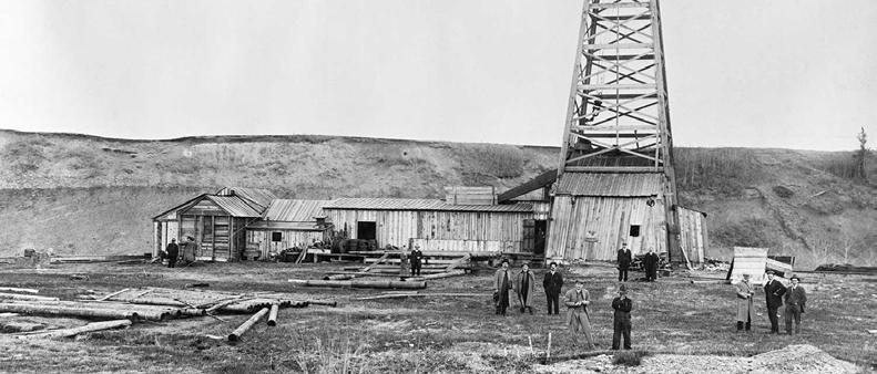
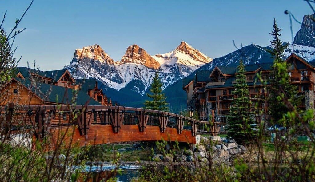
ANNUAL SYMPOSIUM AND FIELD TRIP
MAY 20-22, 2024
CANMORE, ALBERTA, CANADA

“Exploration in the Canadian Rocky Mountain Foothills: From Drilling the Bumps to Deeper Insights”
TURNER VALLEY FIELD
1914
Vol. 73, No. 4 | www.rmag.org 45 OUTCROP | April 2024
PETROLEUM HISTORY INSTITUTE
REGISTER AT https://petroleumhistory.org/2024petroleum-history-symposium/
clintontippett88@gmail.com vrgreen1@telus.net
DISCOVERY,
CANMORE QUESTIONS?
Water, Water, Not Everywhere
Review by Rasoul Sorkhabi, University of Utah
The Three Ages of Water: Prehistoric, Past, Imperiled present, and a Hope for the Future
PETER
GLEICK (PUBLIC AFFAIRS, NEW YORK, 2023)
Water Always Wins: Thriving in an Age of Drought and Deluge
ERICA GIES
(UNIVERSITY OF CHICAGO PRESS, 2022)
In our science and geography classes we all have learned a few basic facts about water: Life depends on water (as well as on the air and food). No water, no life. In fact, the primordial life forms on Earth, single cells, first evolved in a water-rich environment. And even today, after billions of years of evolution, land-dwelling human bodies, depending on their age, gender and weight, contain 50-70 percent water by weight. The agricultural revolution and the earliest civilizations emerged on the banks of major rivers, and these rivers still support large settlements and populations. With water covering 71 percent of Earth’s surface, our planet is more oceanic than terrestrial. Nonetheless, nearly 97 percent of water is saline, and of the remaining three percent freshwater, two thirds are locked in glaciers. So, for practical purposes, we have access to only one percent of liquid freshwater, hence the famous line in Samuel Coleridge’s “Rime of the Ancient Mariner” (1798): “Water, water everywhere, nor any drop to drink.” As individuals, we all know these self-evident truths about water, but as a society, as corporations and cities, we tend to forget them, and take water resources for granted and ignore the natural limitations and quality of the water cycle. Today, more than two centuries after Coleridge, and after several decades of rapid industrialization, population growth, environmental degradation and climate change, our freshwater resources
Water for All: Global Solutions for a Changing Climate
DAVID
SEDLAK (YALE UNIVERSITY PRESS, 2023)
are hugely at risk. Water has become a global issue, and nowhere more evident and acute than in the American West, North Africa, and Middle East. In recent years, a number of books have been published on water crisis. I have picked three new books for this review; interestingly they were all written by three authors from California—a state which has faced water shortages and drought in recent years. Peter Gleick (The Three Ages of Water: Prehistoric, Past, Imperiled present, and a Hope for the Future) is a member of the National Academy of Sciences and a cofounder of the Pacific Institute, an independent water research group based in Berkeley. Erica Gies (Water Always Winds: Thriving in an Age of Drought and Deluge) is a California-born and based journalist who has extensively written about water and climate change for National Geographic Explorer, Scientific American, and other magazines. David Sedlak (Water for All: Global Solutions for a Changing Climate) is a professor of civil and environmental engineering at the University of California in Berkeley and director of the Berkeley Water Center. Although their books understandably overlap to a certain extent, each book has its own perspective and focus.
Peter Gleick (The Three Ages of Water: Prehistoric, Past, Imperiled present, and a Hope for the Future) offers a big picture of humanity’s interactions with water resources in three dramatic Acts, as mentioned in
OUTCROP | April 2024 46 Vol. 73, No. 4 | www.rmag.org BOOK REVIEW
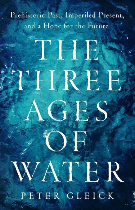
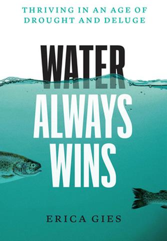
the book’s subtitle: Prehistoric Past, Imperiled Present, and a Hope for the Future. The First Age of Water on Earth, according to Gleick, encompasses the 4.5-billion years of Earth’s history up until about 12,000 years ago, when the last glaciers melted and a warm interglacial age began. Humankind, depending on how we define it, appeared in the past two or three million years (with Homo sapiens in the past two or three hundred thousand of years). In the First Age of Water, small pockets of humans, depending on where they lived, had access to plenty of ice or water. Their relationship with water was unplanned but appreciative and intimate. The Second Age of Water—the past 12,000 years or what geologists call the Holocene (“All Recent” Age), has been relatively a warm and humid climate. During this period, human populations flourished; they practiced horticulture and agriculture; they dug water wells and invented water mills; civilizations emerged on the banks of major rivers across the world; marine navigation spread human settlements, trades and wars across the oceans; the culmination was the Industrial Revolution in the 18th and 19th centuries. But the Second Age of Water also led to environmental degradation and global threats to water resources—to the dawn of the Third Age of Water. Gleick believes that we are “at fork in the road of own survival.” We can either continue mismanaging, wasting, polluting, and damaging water resources, or start protecting, restoring and optimally managing them. The present trend of environmental
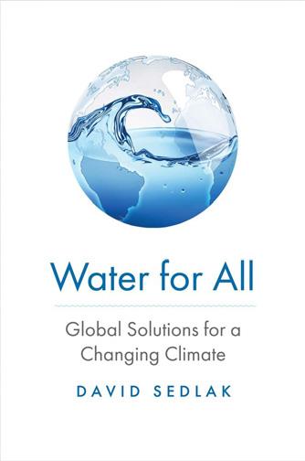
degradation actually began in the 1950s which marks the beginning of what scientists have nicknamed the Anthropocene (the “human-dominated age”).
Avoiding the runaway global warming is probably the most critical challenge of our time and of our environment because climate fundamentally affects the water cycle and resources in myriad ways. This is specifically illustrated in the subtitle of Erica Gies’s book: Thriving in an Age of Drought and Deluge. Depending on where you live, the global warming accelerates both droughts and floods. Gies introduces the concept of “Slow Water”—to “let water be water, to reclaim space for it to interact with the land.” Fast Water—overusing, wasting, polluting, ruining and misplacing water resources—is like “Fast Food and all its ills.” Through ten chapters, Gies covers her subject-matter chronologically. After describing the crisis that we are in, she proceeds to discuss water resources in rocks and soil (chapter 2), water’s interactions with life (chapter 3), water engineering in ancient times (chapters 4 to 6), and water in the Industrial Era (chapter 7). The final three chapters offer glimpses of the near future and people’s adaptation, innovation, and common-sense restoration toward water. Gies rarely discusses the political, economic or technological challenges and solutions to the near future of water. Overall, her book adopts a journalistic style, with illustrative case studies and field trips, and an environmentalist perspective calling for ancient wisdom and respect for nature.
Vol. 73, No. 4 | www.rmag.org 47 OUTCROP | April 2024
One of the most interesting and informative aspects of Gies’s book is her stories of “water detectives”— those who are trying to find and map lost rivers, ghost streams, and buried creeks that were misplaced by human development projects and urbanization. “Worldwide,” Gies writes,” only one-third of rivers longer than 620 miles travel uninterrupted to the ocean. Most of the remaining free rivers run through remote parts of the Arctic, Amazon, and Congo. All the rest have been dammed, straitjacketed in levees, and dredged to make shipping channels.”
David Sedlak (Water for All: Global Solutions for a Changing Climate) offers a more technical (and indeed a technocratic) and an optimistic view with regard to Gies’s “near future” and Gleick’s “Third Age” of water.” Sedlak points out that even ancient societies faced water crisis of their own time and geography; nevertheless, he agrees that our present water crisis is part of the Great Acceleration in population, economic and industrial growth—the so-called Anthropocene that began in the 1950s. Sedleck prefers to deconstruct the so-called “Global Water Crisis” into six specific issues:
(1) Water for the wealthy people living in affluent cities (he specifies Santa Barbara as a telling example);
(2) water for the many and majority of people living in low- to middle-income countries and cities in Asia and South America; (3) water for the unconnected—nearly a quarter of world population in rural and less-developed countries that have no access to safe water and sanitation; (4) water for good health in general; (5) water for food and agriculture; and (6) water for ecosystems such as rivers and lakes. In this way, Sedlak attempts to analyze and offer solutions to each of the six distinct water crises.
Sedlak discusses various technical solutions, both large-scale infrastructural projects including desalination of sea water, construction of more efficient dams and canals, and groundwater wells, as well as small-scale but numerous devices such as drip irrigation of water to plant roots and other water conservation schemes. He highlights the recycling and treating of sewage for crop irrigation and underground reservoir refilling as a significant technological solution in many parts of the world. Finally, Sedlak remarks that some of our water issues require no technologies; they can be solved through better policies and regulations. Sedlak’s new book is a follow-up to his previous book
Water 4.0: The Past, Present, and Future of the World’s Most Vital Resource (2014).
As I write this review in January 2024, the human population has surpassed eight billion. I also write this in Utah, a typical part of the arid and water-deficient American West. But water has become a major environmental, economic, and socio-political issue of our time on a global scale. With the changing climate, water issues in myriad facets—from shortage, drought and desertification to floods, hydropower dams, and conflicts over common “rivers” (which is the very origin of the word “rivalry”) will pose daunting challenges to communities, governments, and economic entities. We need “water literacy” for the public as well as politicians and policy-makers. In my personal library I have a shelf of books on hydrology and water issues. These three new books are good additions to the literature. One of the classic works on water crisis (which regrettably has not been acknowledged by any of these new authors) is Mark Reisner’s Cadillac Desert: The American West and the Disappearing Water, published in 1986 but has been revised and reprinted since then. Reisner, who died in 2000 at untimely age of 52, was a skillful environmental and investigative journalist, and his book, still in press, has raised the public consciences about water issues in the American West for decades.
The three new books introduced here are useful for the educated public, policy-makers, and college teachers who are concerned about the worsening water issues. The data and materials used in the books are well documented and cited (although none of them offer a general bibliography). Pick any of these books, and it will depict and discuss a cross section and range of water issues facing humanity. Written by experts but in a non-technical language, these new books distill a vast amount of recent information and ideas and offer an in-depth understating of how water resources are used or misused, and what can be done to avoid catastrophic water wars and socio-political water stresses in the coming decades.
Rasoul Sorkhabi, PhD, is a research professor of geology at the University of Utah’s Energy & Geoscience Institute and Department of Civil & Environmental Engineering in Salt Lake City.
OUTCROP | April 2024 48 Vol. 73, No. 4 | www.rmag.org
REVIEW
BOOK
RMAG Foundation Scholarship Winners
The RMAG Foundation supports earth science research and academic studies for graduate and selected undergraduate students by providing students with scholarship awards each year. This February, the RMAG Foundation Trustees reviewed 38 scholarship applications representing fourteen different universities. And we are proud to announce, that for 2024, eleven scholarships have been granted totaling $59,600. Additionally, all student applicants and the advisors of scholarship winners will receive a one-year free RMAG membership from the RMAG Foundation.
The thesis and dissertation topics received this year showcased the creative and diverse research being conducted by the participating universities. The RMAG Foundation Trustees congratulate these students for their outstanding academic successes and thank all RMAG Foundation donors for sustaining these scholarship.
GARY BABCOCK SCHOLARSHIP
Victor Fakeye, PhD candidate – Colorado School of Mines
“Integrated Electro-Hydraulic Fracturing and Real-Time Monitoring for Carbon Negative In-Situ Mining and Carbon Mineralization”
BOLYARD FAMILY SCHOLARSHIP
Natali Kragh, PhD candidate – Montana State University
“Utilizing volcaniclastic rocks to constrain the timing and volume of Late Cretaceous volcanism”
ROBERT M. CLUFF SCHOLARSHIP
Eric Stautberg, PhD candidate – Colorado School of Mines
“The Identification and Characterization of Sedimentary Geothermal Play Types on the Texas Gulf Coast for Electrical Power Generation”
COLORADO SCHOOL OF MINES SCHOLARSHIP
Rachel Williams, PhD candidate –Colorado School of Mines
“Facies controls and timing of fracture formation in Permian (Guadalupian)age muddy and grainy carbonate slope deposits”
NORMAN H. FOSTER SCHOLARSHIP
Matthew Musso, PhD candidate –Colorado School of Mines
“Understanding the hydrodynamics of nonuniform, disarticulated Crinoid grains and their importance in the Mississippian rock record as an indication of flow conditions”
MICHAEL S. JOHNSON SCHOLARSHIP
Izabelle Buentello, MS candidate –Oklahoma State University
“Utilizing a core-based stratigraphic framework to evaluate the reservoir quality of the Caney Shale”
PHILIP J. MCKENNA SCHOLARSHIP
Annie Breyak, Junior – Colorado College
“Paleoecology of Mammals Across the Cretaceous-Paleogene Boundary in the Denver Basin, Colorado”
OUTCROP | April 2024 50 Vol. 73, No. 4 | www.rmag.org
Publish with…
Publish with…
Expanded geologic focus:

Why contribute?
Why contribute?
• Reach
• Quarterly
Entire greater Rocky Mountain West Texas and New Mexico
• Permanent
-Continent
• Quick
Expanded geologic focus:
Expanded geologic focus:
• Every
• Entire greater Rocky Mountain area of North America
• West Texas and New Mexico to northern British Columbia
• Entire greater Rocky Mountain area of North America
• Reach a broad industry and academic audience
• Great Plains and Mid-Continent region
• West Texas and New Mexico to northern British Columbia
• Quarterly peer reviewed journal
• Great Plains and Mid-Continent region
Why contribute?
• Permanent archiving includes AAPG Datapages
• Reach a broad industry and academic audience
• Quarterly peer-reviewed journal
• Quick turn around time
• Every subdiscipline in the geosciences
• Quick turn-around time
https://www.rmag.org/publications/the
• Permanent archiving includes AAPG Datapages
https://www.rmag.org/publications/the
• Every subdiscipline in the geosciences
Expanded geologic focus:
• Entire greater Rocky Mountain area of North America
• West Texas and New Mexico to northern British Columbia
• Great Plains and Mid Continent region
https://www.rmag.org/publications/the -mountain-geologist/ area of North America northern British Columbia region
Email: mgeditor@rmag.org
Vol. 73, No. 4 | www.rmag.org 51 OUTCROP | April 2024
RMAG FOUNDATION SCHOLARSHIP WINNERS
RMAG FOUNDATION PUBLICATIONS GRANT
Lauren Guido, PhD candidate – Colorado School of Mines
“Investigating Changes in Erosivity Along the Path of Post-Wildfire Debris Flows”
RMAG FOUNDATION SCHOLARSHIP
Bruno Belotti, PhD candidate – University of Idaho
“Deposition rates and preservation potential of glacially conditioned sediment through multiple glacial fluctuations”
APRIL 3, 2024
RMAG Luncheon.
STONE-HOLLBERG SCHOLARSHIP
Emma Tombaugh, MS candidate – Utah State University
“Testing Models of Yellowstone Landscape Evolution Through Chronostratigraphy of Shoshone River Terraces”
VETERANS MEMORIAL SCHOLARSHIP
Elisa McGhee, PhD candidate – Colorado State University
“Oceanic Controlling Mechanisms of SwellInduced Micro-icequakes Recorded at Three Near-Ice-Front Seismic Stations on the Ross Ice Shelf, Antarctica”
IN THE PIPELINE
Speaker: Karen Lechtenberg, Talk Title: “Navigating the CCUS Journey: Lessons Learned from Project Scoping to Class VI Permit Submission.” In Person or Online. Denver Earth Resources Library, 730 17th Street, B1, Denver.
APRIL 6, 2024
RMAG-CSM.
Practical Python for Earth Scientists. 9AM-4PM.
APRIL 13, 2024
RMAG On-The-Rocks Field Trip. Cave of the Winds and Manitou Springs.
APRIL 18, 2024
RMAG Coffee Hour. Huckelberry Roasters-Dairy Block, Denver, CO. 10AM.
APRIL 18, 2024
WOGA Lean In.
APRIL 25, 2024
RMAG & DWLS Happy Hour. Joyride Brewing, 2501 Sheridan Blvd, Edgewater, CO. 4-6PM.
MAY 1, 2024
RMAG Luncheon.
OUTCROP | April 2024 52 Vol. 73, No. 4 | www.rmag.org
Louis Taylor from Littleton, Colorado
David Schey from Rio Rancho, New Mexico
Charles Johlgren from Arvada, Colorado
Evan Bartles is a student member from Aurora, Colorado
G. Margeson with Western Mining Services LLC from Parker, Colorado
Judy Wiedenheft-Cole from Leadville, Colorado
Harold Sewell from Castle Rock, Colorado
Kelly Lagomasino from Parker, Colorado
Rob Cifelli with NOAA Physical Sciences Laboratory in Boulder, Colorado
Daniel Spaulding with SM Energy from Denver, Colorado
Peyton Jackson with Cogniset, LLC from Denver, Colorado
Brent Greenhalgh with Wexpro Company from Salt Lake City, Utah
Hunter Eden with Field Geo Services from Greenwood Village, Colorado
Vol. 73, No. 4 | www.rmag.org 53 OUTCROP | April 2024 1 Time 2 Times 6 Times 12 Times Full page (7-1/2” x 9-1/4”) $350 $650 $1,800 $3,400 2/3 page (4-7/8” x 9-1/4”) $250 $465 $1,290 $2,430 1/2 page (7-1/2” x 4-5/8”) $200 $370 $1,030 $1,950 1/3 page horizontal (4-7/8” x 4-7/8”) $175 $325 $900 $1,700 1/3 page vertical (2-3/8” x 9-1/4”) $175 $325 $900 $1,700 1/6 page (2-3/8” x 4-7/8”) $100 $185 $520 $970 Professional Card (2-5/8” x
$30 $55 $155 $290
1-1/2”)
OUTCROP ADVERTISING RATES WELCOME NEW RMAG MEMBERS!
ADVERTISER INDEX
CALENDAR – APRIL 2024
OUTCROP | April 2024 54 Vol. 73, No. 4 | www.rmag.org •Confluence Resources 10 •Denver Earth Resources Library 49 •Donovan Brothers 38 •Larson Geoscience 38 •LMKR Gverse Geographix 44 •Paul Denney 42 •Petroleum History Institute–Call For Papers 45 •Sproule 14 •Tracerco 35
SUNDAY MONDAY TUESDAY WEDNESDAY THURSDAY FRIDAY SATURDAY 7 14 21 28 1 8 15 22 29 2 9 16 23 30 3 10 17 24 4 11 18 25 5 12 19 26 6 13 20 27 RMAG Luncheon. RMAG Coffee Hour. WOGA Lean In. RMAG & DWLS Happy Hour. RMAG-CSM. RMAG On-TheRocks Field Trip.
