

OUTCROP
Newsletter of the Rocky Mountain Association of Geologists
Volume 73 • No. 5 • May 2024


Vol. 73, No. 5 | Silver Sponsors Platinum Sponsor Gold Sponsors SUMMIT
SPONSORS
OUTCROP
Newsletter of the Rocky Mountain Association of Geologists
730 17th Street, B1, Denver, CO 80202 • 720-672-9898
The Rocky Mountain Association of Geologists (RMAG) is a nonprofit organization whose purposes are to promote interest in geology and allied sciences and their practical application, to foster scientific research and to encourage fellowship and cooperation among its members. The Outcrop is a monthly publication of the RMAG.
2024 OFFICERS AND BOARD OF DIRECTORS RMAG STAFF
PRESIDENT Mike Tischer mtischer@gmail.com
PRESIDENT-ELECT Matt Bauer matthew.w.bauer.pg@gmail.com
1st VICE PRESIDENT Lisa Wolff lwolff@bayless-cos.com
1st VICE PRESIDENT-ELECT Nate La Fontaine nlafontaine@sm-energy.com
2nd VICE PRESIDENT Jason Eleson jason@geointegraconsulting.com
2nd VICE PRESIDENT-ELECT Ali Sloan ali@sloanmail.com
SECRETARY Drew Scherer flatirongeo@gmail.com
TREASURER
Holly Lindsey hrlindsey@bafatoy.com
TREASURER-ELECT
Astrid Makowitz astridmakowitz@gmail.com
COUNSELOR
Steve Crouch scrouch@whiteeagleexploration.com
ADVERTISING INFORMATION
Rates and sizes can be found on page 55. Advertising rates apply to either black and white or color ads. Submit color ads in RGB color to be compatible with web format. Borders are recommended for advertisements that comprise less than one half page. Digital files must be PC compatible submitted in png, jpg, tif, pdf or eps formats at a minimum of 300 dpi. If you have any questions, please call the RMAG office at 720-672-9898.
Ad copy, signed contract and payment must be received before advertising insertion. Contact the RMAG office for details.
DEADLINES: Ad submissions are the 1st of every month for the following month’s publication.
The Outcrop is a monthly publication of the Rocky Mountain Association of Geologists
DESIGN/LAYOUT: Nate Silva | n8silva.com
EXECUTIVE DIRECTOR
Bridget Crowther bcrowther@rmag.org
LEAD EDITOR
Nate LaFontaine nlafontaine@sm-energy.com
CONTRIBUTING EDITORS
Elijah Adeniyi elijahadeniyi@montana.edu
Marlee Cloos marlee.cloos@bpx.com
Danielle Robinson danielle.robinson@dvn.com
RMAG CODE OF CONDUCT
RMAG promotes, provides, and expects professional behavior in every engagement that members and non-members have with the organization and each other. This includes respectful and inclusive interactions free of harassment, intimidation, and discrimination during both online and in-person events, as well as any content delivered by invited speakers and instructors. Oral, written or electronic communications that contain offensive comments or demeaning images related to race, color, religion, sex, national origin, age, disability, or appearance are not appropriate in any venue or media. RMAG reminds members of the diversity and mission statements found on our website. Please direct any questions to staff@rmag.org
Vol. 73, No. 5 | www.rmag.org 3 OUTCROP | May 2024 Vol. 73, No. 5 | www.rmag.org 3 Outcrop | May 2024

HAPPY HOUR HAPPY HOUR HAPPY HOUR
FOR MORE INFORMATION ON THESE EVENTS AND TO SEE WHAT ELSE IS COMING VISIT: www.rmag.org/events 2024 NETWORKING EVENTS 2024 NETWORKING EVENTS 2024 NETWORKING EVENTS JANUARY FEBRUARY MARCH APRIL MAY JUNE 11* 27 26 25* 21 25 JULY AUGUST SEPTEMBER OCTOBER NOVEMBER 30 27 24 29 19
TUESDAY 4PM *THURSDAY JANUARY FEBRUARY MARCH APRIL MAY JUNE 10 7 6 3 1 5 JULY AUGUST SEPTEMBER OCTOBER NOVEMBER DECEMBER 10 7 11 2 6 4 LUNCHEON LUNCHEON LUNCHEON WEDNESDAY 12PM JANUARY FEBRUARY MARCH APRIL MAY JUNE 18 22 21 18 16 20 JULY AUGUST SEPTEMBER OCTOBER NOVEMBER 18 15 19 17 21 COFFEE HOUR COFFEE HOUR COFFEE HOUR THURSDAY 10AM MARK YOUR CALENDARS

OUTCROP
6
16 Lead Story: Tales of a Grand Canyon, Geologic Highlights of a Colorado River Trip– Part 2
10 RMAG April 2024 Board Of Directors Meeting
10 Save The Date: North American
11 On-The-Rocks: 2024 Field Trips
13 On-The-Rocks: Raft The Grand Canyon 15 Dinosaur Ridge, Outreach Volunteers Needed!
RMAG Monthly Coffee Hour
RMAG Monthly Happy Hour
On-The-Rocks: Red Rock Canyon Open Space Field Trip
35 On-The-Rocks: Geology And Paleontology Of The Canon City Area
41 RMAG 2024 Golf Tournament
43 Consider Publishing In The Outcrop
50 RMAG Foundation: Neil Harr Award and Brown Field Camp Scholarship Winners

COVER PHOTO
View looking upstream from a point immediately above Deer Creek (RMR 136.8), approximately 200 feet (61 m) above river level, and standing on Tapeats Sandstone (note sandstone talus in lower left foreground) Kaibab Plateau (North Rim) is on the skyline. Groups I-III rocks, with selected formations and members labeled as follows (see also Fig. 0-4 in Lead Story, this issue): Group I metamorphic and igneous basement at river level in foreground; overlying Group II diabase sill at distant river level, upwards through Hakatai Shale; and uppermost Group III Tapeats Sandstone upwards to Kaibab Limestone on plateau rim. Group III includes “RC & SP” (Rampart Cave and Sanup Plateau), the “rusty” iron dolomite members of the Muav Limestone that were collectively involved in a landslide called Poncho’s Radical Runup (see Section 7 of Lead Story).
Group III rocks overlie Group II rocks at the Great Angular Unconformity (red line, same as in Fig. 0-4; angularity not apparent in photo); Group III Tapeats Sandstone over Group I metamorphic and igneous basement at Great Unconformity (white line). Note slump features to the right of Bright Angel Shale label; much slumping in the Deer Creek area appears to have been initiated within the Bright Angel Shale. Finally, note the muddy color of the Colorado River, which indicates recent, precipitation-related sediment input somewhere upriver, but below Glen Canyon Dam. Photo courtesy of Gus Hobbs, 2023.
Newsletter of the Rocky Mountain Association of Geologists
FEATURES
Summit
2024 RMAG
Sponsorship Packet
DEPARTMENTS
12
44
New
54
The Pipeline 55 Outcrop Advertising Rates 56 Advertiser Index 56 Calendar ASSOCIATION NEWS 2 RMAG Summit Sponsors 4 RMAG Networking Events
Helium
President’s Letter 42 Hybrid Lunch Talk: Sarah Compton
Hybrid Lunch Talk: Peter Vrolijk 46 Member Corner: Christine Dimon 52 Welcome
RMAG Members!
In
& Hydrogen Conference
23
27
31
CONTENTS

MEMBERS
EVENT ATTENDEES
WEBSITE VISITORS
OUTCROP READERS
EMAIL SUBSCRIBERS
NETWORKING EVENTS
CONTINUTING EDUCATION EVENTS
FIELD TRIPS
COMMUNITY CONTACTS IN 2023 YOUR SUMMIT SPONSORSHIP DOLLARS SUPPORTED: 1,200 2,000 8,000 8,500 5,000 3,500 30 15 9


Geoscience Community:
October 20, 2023
We greatly appreciate every Summit Sponsor and Event Sponsor that has contributed to RMAG over the last year. We could not exist without your support
The Rocky Mountain Association of Geologists celebrated a year of remarkable achievements, bringing together a global community of over 300 geologists for the Helium Conference for one of the first events exploring Helium production from exploration to processing. Monthly Women's Coffee, Membership Happy Hours, and thematic luncheons provided a supportive networking environment. In these gatherings, experts delved into diverse subjects, with topics that spanned from landslides to the intricate geology of the Permian Basin. RMAG also offered classes on oil and gas property valuation, enriching the skill set of members. A core workshop facilitated hands-on learning, and field trips to quarries, crater impacts and other geologic marvels ignited the spirit of exploration. Notably, the association extended its community impact through outreach at community festivals and classrooms across the Denver Metro area, emphasizing our dedication to advancing geological understanding and appreciation.
2024 brings new opportunities for RMAG Your sponsorship dollars will help RMAG bring to fruition an extensive calendar of continuing education opportunities, an exciting Field Trips season, and a dynamic list of luncheon speakers on topics ranging from the state of the industry to hydrogen and more. These dollars will allow RMAG Members impact the next generation at outreach events throughout the community and provide opportunities for the geoscience community to connect and build their network.
Your sponsorship dollars will also support our excellent publications including the monthly Outcrop newsletter and the quarterly Mountain Geologist journal We recognize your financial commitment with inperson signage, and website and publication advertising, as well as through social media before each online event. With a LinkedIn group of almost 3000 members, we make our sponsors visible to the geoscience community for both virtual and in person events
Thank you to those who are already a Summit Sponsor, we look forward to your continued support in 2024. If you are not already a sponsor, please look at the many complementary benefits included with the sponsorship levels. If our annual sponsorships don't make sense for your company, or you want to sponsor something specific, ask about our single event sponsorship opportunities. Please feel free to contact our staff with questions about sponsorship by email: bcrowther@ rmag.org or by phone at 720-672-9898 ext. 102
We and the staff of RMAG thank you all for your continued support and look forward to seeing you in 2024.
Michael Tischer Bridget Crowther 2024 RMAG President RMAG Executive Director
Vol. 73, No. 5 | www.rmag.org 7 OUTCROP | May 2024 P: (720)672-9898 staff@rmag.org www.rmag.org
Denver,
80202
730 17th Street, B1
CO

12
Registration points are c u m u
and can be used for Symposiums or Short Courses. For example a
Sponsor can send 4 people to the 2023 North American Helium Symposium, and register for 4 short courses.
Registration Points are c u m u l a t i v e and can be used for any social event. For example, 1 point means 1 golfer, or 1 registration for Rockbusters. *2 points can be used for a golf hole if that makes more sense for your company.
Registration Points are cumulative for luncheons or one day field trips.
Luncheon & Field Trip Tickets
For all event tickets please contact the RMAG office at staff@rmag.org to use your spots.
OUTCROP | May 2024 8 Vol. 73, No. 5 | www.rmag.org RMAG ANNUAL SUMMIT SPONSORSHIP PLATINUM, GOLD, & SILVER SPONSORSHIP LEVEL PLATINUM GOLD SILVER Contribution Level Monthly Cost $10,000 $835 $5,000 $417 $2,500 $208 Benefits Value $10,000 $5,000 $3,000 RMAG MEMBERSHIP Active or Associate Membership in the Association for employees 4 2 1 RMAG WEBSITE BENEFITS Company Logo on Summit Sponsor Page of www.rmag.org Large Logo & Link Medium Logo and Link Small Logo and Link Articles and Ads on special Advertisers web page 4 articles & 4 large ads 2 articles & 2 medium ads 2 small ads PUBLICATION ADVERTISING
months
Outcrop advertising: To receive 12 full months, company logos and ad art must be received no later than
20th of the month in which you register. The Outcrop (receive benefits for 12 issues, monthly online publication Full page ad 2/3 page ad 1/2 page ad Company Logo listed as an annual Sponsor in The Outcrop Large Logo Medium Logo Small Logo EVENT ADVERTISING Sponsorship will be acknowledged as part the summit sponsors at all RMAG Events. Additional Sponsorship Opportunities will be available for all RMAG Events. Company Logo Looping in Slide Decks Large logo individual Slide Medium logo Small Logo Company Logo on Summit Sponsor Signage at all events Large logo Medium Logo Small logo RMAG EDUCATION EVENTS
Total Educational Tickets 6 3 1 RMAG SOCIAL EVENTS
of
the
l a t i v e
Platinum
Total Social Event Tickets 8 4 2 RMAG
LUNCHEONS & FIELD TRIP TICKETS
Total
5 3 2
RMAG 2024 SUMMIT SPONSORSHIP
All sponsor benefits event tickets follow RMAG event registration deadlines. All benefits end 12 months after registration.
RMAG 2024 ANNUAL SUMMIT SPONSOR OPPORTUNITIES
Platinum Sponsor Gold Sponsor
Silver Sponsor
Summit Sponsorship benefit term is for 12 months! Specify type of payment on signed form, and send logo and advertisements to staff@rmag.org
Company:
Company Representative:
Address:
City: State: Zip Code:
Phone: Email:
Payment Method: Credit Card ACH Check
Credit Card Information: Select Card: AMEX Mastercard VISA Discover
Name as it appears on Credit Card:
Credit Card #:
Expiration Date: Security Code:
Signature:
ACH: contact the RMAG office at staff@rmag.or for directions
Mail Checks payable to RMAG:
Rocky Mountain Association of Geologists (RMAG)
730 17th Street, B1 Denver, CO 80202
RMAG events are subject to change. Cancellation or rescheduling of events does not give the sponsor the right to refund. Summit Sponsors will receive benefits at any new events added into the RMAG schedule.
Thank you for your generous support!
P: (720)672-9898 staff@rmag.org www.rmag.org

730 17th Street, B1 Denver, CO 80202
Vol. 73, No. 5 | www.rmag.org 9 OUTCROP | May 2024
Payment Options
By Drew Scherer, Secretary flatirongeo@gmail.com
Good morning, afternoon, evening, whenever you are reading this issue of the Outcrop! The RMAG Board of Directors met on April 17th, 2024, at 4pm on Zoom. All board members were present besides one. Organizational matters continue to “spring” in the right direction. Event attendance is up, outcrop viewership is up, and our membership roll is increasing as well!
Our inventory of technical and social events is increasing both in quantity and in scope. Additionally, our Continuing Education and Membership committees are hard at work in increasing the quality of these events for you, our lovely members as well! The Finance Committee reported positive net revenue results and is looking for members with professional (or amateur) investment expertise to volunteer for our new ad hoc investment advising group, if interested please reach out to Holly Lindsey.
The wonderful publication has built up a solid

queue of great articles to be released in both the Outcrop and the Mountain Geologist over the coming months. The Geoscience Outreach (GO) Committee would like to remind you to stay up to date on our website and social media for the latest summer outreach events, and to nominate your child’s teacher for our annual Teacher of The Year (TOTY) award for outstanding education in the geosciences.
Lastly, our On-The-Rocks Field Trip committee is gearing up for our summer field trips to kick off in June, with a wide variety from walking tours to hikes, and even a trip by way of mountain bike travel (which yours truly will be leading in July), stay tuned to the website for more information and registration links for these diverse trips. Space is also still available for the 2025 14-day Grand Canyon raft trip; this trip will sell out shortly so register and submit your deposit ASAP if you are interested!
Hope you all have a great May, until next time!
Denver, Colorado ~ April 9-10, 2025
RMAG APRIL 2024 BOARD OF DIRECTORS MEETING
R o c k y M o u n t a i n A s s o c i a t i o n o f G e o l o g i s t s N o r t h A m e r i c a n HELIUM & HYDROGEN C o n f e r e n c e G e o s c i e n c e ~ E x p l o r a t i o n ~ C o m m e r c i a l i z a t i o n
SAVE THE DATE

e l d T r i p s

June 8
June 2 9
July 2 6
Visit Red Rock Canyon Open Space near Manitou Springs and learn about the stratigraphy, structure, sedimentary structures, fossils, the historic quarry remains in the Lyons Sandstone, and a geologic traverse from the Pierre Shale to the Fountain Formation
Join leaders Jon Stone & Lou Taylor to examine dinosaur trackways and bones in the Garden Park Fossil area and BLM land see vertebrate fossils in Harding Sandstone outcrop Plus a tour of the Dinosaur Museum at Royal Gorge
Sept 7
Sept 2 1
October 1 2
A 2+ mile walking tour of some of downtown Denver’s iconic stone buildings, many of which are constructed with rock from Colorado quarries See Yule Marble, Pike’s Peak and S Beaver Creek Granites, and more!
Join Marshall Deacon to Lory State Park in Fort Collins to examine the Lyons, Ingleside Formations eolian stratigraphy
April 18 to May 1
2 0 2 5
G e o l o g y
Trip leaders John McLeod & Dennis Gertenbach to explore Structural and Stratigraphic history of the Eagle Basin
A an exciting field trip to Colorado’s newest State Park, Fisher Peak. Delve into geology wonders spanning from upper Cretaceous formations to Tertiary volcanics, while exploring unique ecology and wildlife
a 14-day geology rafting and hiking adventure down the Colorado River through the Grand Canyon Professor Gary Gianniny will help guide you through the canyon ’ s astonishing record of the evolution of southwestern North America
Dates subject to change View website for additional info

R e d R o c k C a n y o n O p e n S p a c e , C o l o r a d o S p r i n g s
s t o r i e s i n s t o n e : w a l k i n g t o u r o f c a p i t o l h i l l b u i l d i n g s t o n e s
G e o l o g y a n d P a l e o n t o l o g y o f t h e C a n o n C i t y A r e a
E v a p o r i t e s , T u r b i d i t e s a n d S t r o m a t o l i t e s : A W h i r l w i n d T o u r o f E a g l e B a s i n P e r m o - c a r b o n i f e r o u s
P e r m i a n S t r a t i g r a p h y a n d D e p o s i t i o n a l S y s t e m s A l o n g t h e N o r t h e r n C o l o r a d o F r o n t R a n g e
R a f t t h e G r a n d C a n y o n
P e a k s t a t
k
F i s h e r
e P a r
F o r d e t a i l e d i n f o r m a t i o n : w w w . r m a g . o r g / e v e n t s 7 2 0 - 6 7 2 - 9 8 9 8 o r s t a f f @ r m a g . o r g F
F i e l d T r i p s S c h e d u l e d f o r 2 0 2 4 a n d b e y o n d R o c k y M o u n t a i n A s s o c i a t i o n o f G e o l o g i s t s . . . s o f a r !
i
PRESIDENT’S LETTER
By Mike TischerIt’s good to have a plan
Dear RMAG Members,
It’s good to have a plan. I think everybody can agree with that. Planning provides focus, aligns people and allows measures of success. As a project manager, I do it every day at work. Setting up tasks, modifying schedules, verifying scopes – it’s not sexy, but if you want to get something done you need to do it. I’m not sure if I would get much done without a plan and deadlines, these monthly letters included.
In April of last year, the RMAG board decided to do just that, create a strategic plan for the next 5 years. Under the stewardship of Bridget Crowther, our Executive Director, and then RMAG president Ben Burke, the decision was made to work on a new 5-year plan for the organization. The last RMAG strategic plan had been done a few years back. With a rapidly changing post-COVID geoscience landscape with greater focus on renewables, climate change, and modified work habits, the time was ripe to look at how we could better serve the community and position ourselves as a successful organization for the decades to come.
So, in May of 2023, a select group of RMAG volunteers, comprised of the RMAG Board of Directors and augmented by a few past presidents and other dedicated volunteers, set out to discuss RMAG’s strength and weaknesses and the resulting opportunities and challenges these may pose. A timeframe of 5 years was agreed upon to provide
Goals and implementation timeline for RMAG’s strategic plan 2025-2029:


OUTCROP | May 2024 12 Vol. 73, No. 5 | www.rmag.org

the Grand Canyon
April 18 to May 1, 2025

Sites Include :
Elves Chasm Gneiss
Redwall Cavern Marble Canyon
Vasey’s Paradise
The Great, and lesser unconformities And more!
$ 7,500 Members
$8,000 Non-Members
$ 1,000 non-refundable deposit required
Save Save Saveyourspot yourspot yourspot


Vol. 73, No. 5 | www.rmag.org
LEARN MORE AND SAVE YOUR SPOT TODAY: WWW.RMAG.ORG/GRANDCANYON
Raft
enough time to fully implement four large-scale objectives and goals that will significantly bolster the organization. These goals are (see the attached figure for more detail):
• Get to better know our membership
• Expand the diversity of geoscience branches represented within RMAG
• Develop a sustainable marketing plan
• Ensure fiscal responsibility I encourage you to take a look at the plan and let us know what you think. It’s available to everyone on our website. [link added] Please direct all feedback to staff@rmag.com. We look forward to hearing from you.
One final word on this topic. To me, strategic plans are a bit like geologic models, they are very often necessary and useful to get your work done. Yet, like models, you should expect to make frequent adjustments and you should not be surprised nor afraid when some things don’t work out and plans change. If your plan works perfectly and you get everything done you set out to do, you haven’t pushed yourself enough. On the other hand, if you fail to accomplish a significant
because you don’t understand the scale of your tasks. If you have ever worked as an exploration geologist you will be very familiar with this tradeoff between being too conservative and too aggressive. As an organization, we will review our strategic plan regularly, at least once a year to make sure we are on track with our tasks, to align with newly incoming RMAG leadership volunteers and to react to potential outside factors that require adjustments to the plan. We don’t want to be too conservative nor too aggressive with our goals.
Before I let you go, I would be remiss not to acknowledge the many volunteers in our organization who have helped craft this living document, starting with our Executive Director, Bridget Crowther, and past president, Ben Burke. Following not far behind are Matt Bauer, Steve Crouch, Rob Diedrich, Jason Eleson, Rebecca Johnson, Sandra Labrum, Nate LaFontaine, Holly Lindsey, Astrid Makowitz, Ron Parker, Anna Phelps, Drew Scherer, Ali Sloan, David Taylor, and Lisa Wolff. Thank you all for your time and dedication to this organization!


PRESIDENT’S LETTER production company confluenceresources.com Confluence Resources is an upstream exploration and production company confluenceresources.com


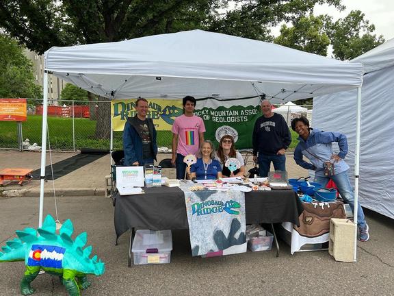

Vol. 73, No. 5 | www.rmag.org 15 OUTCROP | May 2024 OUTREACH EVENT VOLUNTEERS NEEDED! Upcoming Events W e s t w o o d ' s C i n c o D e M a y o , M a y 4 & 5 t h J u n e t e e n t h , J u n e 1 5 & 1 6 t h P r i d e F e s t , J u n e 2 2 & 2 3 t h w w w . r m a g . o r g Volunteer @ rmag.org/events Questions? Email: s t a f f @ r m a g . o r g
TALES OF A GRAND CANYON GEOLOGIC HIGHLIGHTS OF A COLORADO RIVER TRIP
PART 2
LEW KLEINHANS, Consulting Exploration Geologist & River Runner
MADELINE MARSHALL, Assistant Professor of Earth & Environment, Albion College
KJ McDONOUGH, KJM Consulting
INTRODUCTION TO PART 2:
We continue to share the geologic highlights of our 9-day raft trip down the Colorado River through the Grand Canyon (Fig. 0-2). In Part 1 (Sections 1-4, April 2024 Outcrop), we began our stratigraphic roller coaster ride through deep time at a point just above the Permian Kaibab Limestone (visible at the rim and near the very top of this month’s cover photo and Fig. 0-4A, respectively). We then floated down river and down section in quick succession through much of the Paleozoic Group III rocks. We observed elements of the Permo-Triassic Unconformity, Grand Canyon’s hydrology and plumbing systems, sequence stratigraphic cyclicity, and incision and fill of ancient valleys.
In Part 2 this month, we continue our initial stratigraphic roller coaster descent through the Paleozoic section (Group III rocks), across the Great
Unconformity and into the Early Proterozoic metamorphic and igneous basement rocks (Group I) in Upper Granite Gorge (River Mile (RM) 78). At RM ~108, we climb back up section past the Great Unconformity and into the Group III Cambrian Tapeats Sandstone again. We then plummet back down into the Group I basement rocks of Middle Granite Gorge (RM ~126.3), including the very oldest (1.84 Ga) Elves Chasm Gneiss (RM 115). From there, we climb back up-section, level out for a while in the Group III Cambrian Muav Limestone, and then ascend to the stratigraphically highest point on our roller coaster, the recent (<1 Ma) Group IV volcanic rocks (RM ~177).
Part 2 includes more recent geologic highlights, from incision by the Colorado River to dramatic volcanic events that characterize the last part of our trip. Along the way, we visit the Nankoweap Outwash Delta and Ancestral Puebloan granaries, learn how
OUTCROP | May 2024 16 Vol. 73, No. 5 | www.rmag.org
LEAD STORY

FIGURE 0-2: (repeated from Part 1) Location of “Our Trip” and Grand Canyon relative to the Colorado and Little Colorado Rivers, surrounding plateaus, and Grand Canyon Village on the South Rim. The area spans indigenous territories including those of the Southern Paiute, Diné (Navajo), Hopi, Havasupai, Zuni, Hualapai, and Yavapai-Apache tribes. Circled numbers correspond to the approximate beginning points of the eight topical sections in text. Our “put-in” (start of trip) is at No. 1 (Lees Ferry, RMR 0), and our “take-out” (end of trip) is at RML 187.4, the Whitmore Helipad (after Esri, 2020). Note that river trend near No. 5 (Nankoweap Delta) approximately parallels that of the Butte Fault, which is mentioned in both Sections 5 and 6 .
travertine dating helps decipher incision rates and age of the Grand Canyon, and observe how recent processes (landslides! volcanism!) impact the past, present and future courses of the Colorado River.
All eight sections of our 2-part article are listed below. As you read Sections 5-8 covered in this issue, note once again the interconnectivity of the features discussed. We think that you will begin to appreciate how the Grand Canyon and the Colorado River are both witnesses to and agents of profound change
within their confines and within those experiencing them.
Part 1 (April, 2024):
1. Permo-Triassic Boundary / Unconformity (RM 0-1)
2. Economic Geology, Hydrology and Plumbing Systems (RM 1-11.7)
3. Sequence Stratigraphy and Cyclicity (RM 11.7-37.8)
Vol. 73, No. 5 | www.rmag.org 17 OUTCROP | May 2024

FIGURE 0-4: (repeated from Part 1) A. Schematic E-W cross-section of the Grand Canyon region showing the four main “Groups” of rocks: Group I) Early Proterozoic (1840-1680 Ma) igneous and metamorphic basement; Group II) Middle + Late Proterozoic (1254-742 Ma) “tilted rocks”; Group III) Paleozoic (Cambrian-Permian, 508-240 Ma) “layered, flat-lying rocks,”; Group IV) Recent (<1 Ma) volcanic rocks. The major unconformities that separate them are: Great Nonconformity (white line), Great Angular Unconformity (red line), and Great Unconformity (black line) (after Karlstrom et al., 2021). Sections 1-8 of this article, also on the map in Figure 0-2, are labeled in their approximate stratigraphic locations. B. View downstream from RM 107-108 showing portions of the same three main rock packages. Red line marks Great Angular Unconformity on top of Group II rocks.
4. Temple Butte Formation Incised-Valley Systems and Root Traces (RM 37.8-52.5)
Part 2 (May, 2024):
5. Nankoweap Delta Formation and Occupation (RM 52.5-57.3)
6. Incision Rates and River / Canyon Age (RM 57.3-137)
7. Landslides and Poncho’s Runup (RM 137-175)
8. Recent (< 1 Ma) Volcanism (RM 175-187.4)
5. NANKOWEAP DELTA FORMATION AND OCCUPATION (RM 52.5-57.3)
In addition to being “sinks for sediments,” valleys like those associated with the Temple Butte Formation (Section 4 in Part 1, April 2024 Outcrop) can also be important conduits for sediments and people. A case in point is the valley of Nankoweap Creek (Canyon) and the outwash delta that issues from its mouth at its confluence with the Colorado River (Fig. 5-1A; RMR 52.8). Nankoweap Canyon, together with two subordinate adjacent canyons on river right, has been a major source of deltaic sedimentation through time. The delta was also an important Ancestral Puebloan (AD 1100) occupation site, with nearby associated elevated granaries (Fig. 5-1A and B).
High sediment input from the outwash delta into the Colorado River is responsible for the meandering, gravel-bar-laden river course immediately below the canyon mouth (Fig. 5-1B). But
OUTCROP | May 2024 18 Vol. 73, No. 5 | www.rmag.org
LEAD STORY

5-1: A. Nankoweap Delta (RMR 52). Upstream is to the left. View looks across delta and river to very steep wall of Marble Canyon reentrant, which from river level upward comprises: talus-covered Bright Angel Shale and partially covered Muav Limestone; central cliff of Frenchman Mountain Dolostone overlain by Redwall Limestone; then dark red, ledge-forming but unusually steep Supai Group and overlying, partly talus-covered Hermit Shale; and uppermost cliff of white Coconino Sandstone. Nankoweap Creek flows from the left side of photo into the river (arrow). Note walking trails for scale and follow them towards the end of remnant debris ridge, where evidence of Ancestral Puebloan occupation can be found amidst pickup-truck-sized blocks of predominantly Kaibab Limestone (circled area). The ridge and delta are likely the products of both debris flow(s) from Nankoweap Canyon and rock fall(s) from the opposite side of the river. B. View looking downstream of Nankoweap Delta, including Ancestral Puebloan granary entrances on right side of photo. Photo courtesy of Gus Hobbs, 2023.
the source of that sediment may also have included rockfalls from the oversteepened wall opposite the delta on river left.
High sediment input from Nankoweap Creek and adjacent canyons may have helped force the river to the left around the delta, forming the concave excavation (reentrant) of Marble Canyon on river left, opposite the delta (Fig. 5-1A; RML 52.8). Sediment delivery from Nankoweap Canyon on top of the delta is evidenced by the presence of rounded boulders of lithologies not found on river left. These include boulders of Cambrian Tapeats Sandstone (Fig. 5-2A), Precambrian stromatolites (Fig. 5-2B), algal laminates, and possible Precambrian hornfels, all of which are typical of the Precambrian Group II rocks which are exposed up Nankoweap Canyon.
Forcing of the river to the left around the delta, however, could have contributed to river left wall
steepening and more frequent rock falls, which could have in turn contributed to delta formation. Hereford (1984) reports several lines of evidence for rock fall contribution including: 1) steepness of reentrant wall; 2) large boulders of Kaibab Limestone that litter the top of the highest part of the delta and reportedly fine westwards away from the steep reentrant wall; 3) relatively high angularity of clasts in the underlying delta breccia; and 4) composition of some delta breccia clasts that seem to be devoid of lithologies exclusive to Nankoweap Canyon. While none of these necessarily preclude a Nankoweap Canyon debris flow source, the easiest source for the large Kaibab boulders would be the Kaibab Limestone rim above the reentrant on river left.
The view southeast and downstream in Figure 5-1B is one of the most picturesque in the Grand Canyon (RM ~54). It is also significant because this
Vol. 73, No. 5 | www.rmag.org 19 OUTCROP | May 2024
LEAD STORY
FIGURE

FIGURE 5-2: Select boulders found atop Nankoweap Delta: A. Cambrian Tapeats Sandstone with its characteristic arkosic composition. B. Stromatolitic boulder, likely from the Proterozoic Chuar Group that is exposed up Nankoweap Canyon but not present in the section on the opposite side of the river. Scale bar has one-centimeter increments.
OUTCROP | May 2024 20 Vol. 73, No. 5 | www.rmag.org LEAD STORY
linear, NW-trending stretch of river (just below circle No. 5 in Figure 0-2) is controlled by the similarly-trending Butte Fault, which is situated only 1.5 miles to the southwest of the river in this location. This classic reactivated fault continues to control both sedimentation and fluid flow, the latter of which indirectly led to the deposition of abundant travertine (calcium carbonate), a topic of our next section.
6. INCISION RATES AND RIVER / CANYON AGE (RM 57.3-137)
Canyon incision by the Colorado River between Kwagunt Rapid (RMR 56) and the confluence with the Little Colorado River (RML 61.5; see cover photo) has exposed the contact of the relatively permeable Cambrian Muav Limestone with impermeable
underlying Bright Angel Shale. For some ancient (< 1 Ma), downward-percolating, calcium-carbonate-saturated, “Upper World” waters (Fig. 2-1 Repeated From Part 1, April 2024 Outcrop), encountering impermeable Bright Angel Shale was the end of the road. This contact thus became an important exit point for “Upper World” waters to emerge as springs. Where these solutions reached Colorado River gravels, travertine cemented them (Fig. 6-1A) and preserved the approximate base levels (“straths”) at which the ancient river incised bedrock (Fig. 6-2). These travertine-cemented gravel deposits include river-bottom features such as pebble-filled potholes formed by pebble-laden current vortices that drilled down into bedrock (Fig. 6-1B).
Uranium-series dating of travertine allows

FIGURE 2-1: (repeated from Part 1) Schematic model for spring and travertine formation on the Colorado Plateau (including Grand Canyon). Blue arrows represent water recharged by precipitation on the surface and infiltrating into the Coconino and Redwall-Muav aquifers. Red arrows represent deeply circulated waters and gasses rising along faults and mingling with existing groundwaters; magma also rises along these faults. Large boxes highlight characteristics of “Lower World” and “Upper World” waters; small boxes along groundwater flow paths indicate regions of solute acquisition, transport, and deposition. Red/blue arrows on the left side of the figure designate mixed-water exit points that may lubricate landslide detachment points (as discussed in Section 7), particularly in the Bright Angel Shale. GU=Great Unconformity; TB=Temple Butte Formation. Figure modified after Crossey and Karlstrom, 2012.
Vol. 73, No. 5 | www.rmag.org 21 OUTCROP | May 2024
LEAD STORY
travertine-cemented gravels associated with ancient bedrock straths of different ages to be identified and dated. Together with their respective elevations, these strath ages can then be used to calculate river incision rates. Figure 6-2 shows a river stretch at approximately RML 57 where several straths have been identified and dated, giving bedrock incision rates averaging approximately 138 m/Ma (460 ft/ Ma) (Crossey and Karlstrom, 2012; Pederson et al., 2003). At that rate, a mile-deep canyon such as the Grand Canyon could be incised in approximately 11.5 million years.
The nature and timing of Grand Canyon incision and the integration of the Colorado River to its current “source-to-sink” configuration have been the subject of much discussion (e.g., see Ranney, 2012, for an excellent review). However, most workers have converged on a time frame well within the last 11.5 million years, perhaps even as recently as the last 5-6 million years. The current Colorado River configuration may result from adoption of courses that exploited segments of older drainages. In addition, incision rates can be significantly higher at knickpoints, where drainages encounter relatively abrupt bedrock surface displacements associated with steep, active faults that cross them. An example is Toroweap Fault, which crosses the river at RM 179.6 and helps localize Lava Falls, Grand Canyon’s most anticipated rapid (Section 7). Episodic down-dropping on the downstream side of this fault increased the river gradient, increasing the Colorado River’s incision rate there. Moreover, the fault localizes Prospect Canyon on river left, and debris supplied by the canyon to the river significantly contributes to the formation of Lava Falls Rapid (shown in Fig. 8-5A).
The travertine springs just discussed are currently inactive, and this begs the question as to what turned them off. Two important factors may help explain this: 1) groundwater movement in the region is northerly, from the San Francisco Peaks recharge area (Fig. 2-1); and 2) situated between these travertine springs and that source area lies the Little Colorado River, which is fed by calcium-carbonate-saturated spring waters (Fig. 1-4 in Part 1, April 2024 Outcrop). One hypothesis is that incision by the Little Colorado River ultimately intercepted those

6-1: A. Travertine-cemented Colorado River gravels at RML 57. B. Travertine-cemented Colorado River gravels within a pothole drilled into Bright Angel Shale at the same location (near RML 57).
southerly-sourced, calcium-carbonate-saturated groundwaters and turned off their northerly flow (Crossey and Karlstrom, 2012).
Turning off surface fluid flow can also happen downstream of an actual spring or within a creek or river via damming and resulting diversion. Classic examples of these are present in both of the next two sections and are respectively associated with
OUTCROP | May 2024 22 Vol. 73, No. 5 | www.rmag.org
LEAD STORY
FIGURE


Vol. 73, No. 5 | www.rmag.org 23 OUTCROP | May 2024 COFFEE HOUR MONTHLY, THIRD THURSDAY @ 10 AM MAY 16, 2024 Free / RSVP AT RMAG.ORG/COFFEE SPONSOR TODAY VIBE COFFEE 1490 CURTIS STREET Denver, CO 80202 Email Staff@rmag.org
diversion by landslides (Section 7) and lava flows (Section 8).
7. LANDSLIDES AND PONCHO’S RUNUP (RM 137-175)
Most side drainages entering the Colorado River in Grand Canyon do so at grade, meaning that they have gradually incised down into bedrock to the same level as the Colorado River. The confluence of Deer Creek with the Colorado River, however,
is a spectacular exception, with its 180-ft (55-meter)-high waterfall situated less than 200 ft (60 m) from the river (RMR 136.9; Fig. 7-1A). It is a classic example of a knickpoint, where an incision rate is accelerated by a dramatically steepened gradient. In this case, the steepened gradient evidenced by Deer Creek’s waterfall is the result of damming of a previous Deer Creek location by landslides and diversion of the creek over a cliff of Tapeats Sandstone (Figs. 7-1A-C). Like Niagara Falls, which is the largest

6-2: Travertine exposed at RML ~57.3, just below Kwagunt Creek (RMR 56.4). Now inactive, calcium carbonate springs located at the Muav Limestone / Bright Angel Shale contact percolated through and cemented talus and underlying ancient river bottoms. Shown are data associated with three locations where river bottom or near river bottom gravels were dated (e.g., 385 ka = 358 thousand years old), their heights above current channel bottom were measured (e.g., 36 m), and the associated incision rate calculated (e.g., ~151 m/Ma). Measured heights above current channel bottom take into consideration interpreted stratigraphic location of cemented gravels relative to reach-averaged pool depth. Average incision rate for the three rates shown is ~138 m/ma. After Crossey et al. (2012) and Pederson et al. (2003).
FIGURE 7-1: (opposite page) A. Deer Creek Falls (RMR 136.9) cascading over the Great Unconformity (white dashed line) defined by Cambrian Tapeats Sandstone over Vishnu basement. Photo courtesy of Gus Hobbs, 2023. B. Oblique Google Earth (2014) image looking north and showing the locations of earlier (1), later (2) and present-day (3) Deer Creek and its associated waterfall (white arrow). Landslides sequentially blocked and diverted previous courses of Deer Creek, which still serve as buried conduits for water and support vegetation visible at locations 1 and 2. Older landslides are similarly interpreted to have filled Colorado River paleo-channels like the one in Surprise Valley, which is situated just out of view to the north and parallel to the present-day river. Locations of Poncho’s runup slabs 3 and 4 are outlined and labeled (light blue, also in Fig. 7-2). The Great Unconformity is shown with a white dashed line; yellow arrow indicates the same contact location as in C. C. Panoramic photo from river left shows the Great Unconformity (white dashed line) at Deer Creek (RMR 136.7) with rafts for scale. Deer Creek Falls is at center (white arrow, labeled 3, also shown in A and B). To the right (upstream), Cambrian Tapeats Sandstone onlaps (yellow arrow) a Group I basement paleo-island. Looking downstream, the patch of vegetation near river level shows where Deer Creek Falls previously emerged (labeled 2, as in B). Farther downstream, the tan-colored slope (black arrow) is part of the Surprise Valley landslide complex (also shown in B).
OUTCROP | May 2024 24 Vol. 73, No. 5 | www.rmag.org
LEAD STORY
FIGURE

Vol. 73, No. 5 | www.rmag.org 25 OUTCROP | May 2024 LEAD STORY

FIGURE 7-2: Google Earth (2014) oblique view of four depositional remnants of “Poncho’s Radical Runup.” Approximate extents of all four remnants have dashed outlines. Location is along the south slope of Grand Canyon, from RM 136-137; upstream is eastward to left. Remnant labels 2-4 are placed immediately above two prominent Muav members (Sanup Plateau and Rampart Cave) interbedded with the Bright Angel Shale (also labeled on cover photo). These two members appear as rusty-brown parallel “tracks” running from beneath each remnant slab over to the next one. Base of the lowest cliff above the slabs is ~1000 ft above the Colorado River, and marks the minimum height of Poncho’s runup. Slabs 3 and 4 are also outlined in Figure 7-1B.
knickpoint in the US, Deer Creek is now rapidly incising and retreating as it cuts down through the Tapeats Sandstone. Figure 7-1B is a Google Earth image showing the location of present-day Deer Creek, its waterfall, and two previous Deer Creek locations. Deer Creek’s locations (present-day plus two previous; Fig. 7-1B) are testimony to the complex landslide history in this part of the Grand Canyon. This area hosts the “Surprise Valley landslide complex” (e.g., black arrow at left in Fig. 7-1C; Robertson et al., 2021). Large-scale, deep-seated bedrock landsliding in the Grand Canyon is most significant between RM 130-140 (especially RM 134-138), where the Surprise Valley landslide complex and Deer Creek are located. Surprise Valley itself is just
north of and parallel to the present-day Colorado River between Tapeats Creek (RMR 134.4) and Deer Creek (RMR 136.9). It is atypical (a surprise) in that perched valleys adjacent to and relatively close to the river corridor are not common in the Grand Canyon. Surprise Valley is also interpreted to be underlain by a Colorado River paleo-channel.
The complex history of incision and landslides is also demonstrated by another unusual phenomenon. The mixed-water exit points that occur at permeability and geomechanical boundaries (see Fig. 2-1) may lubricate surfaces as glide planes, such as those within the Bright Angel Shale, which can help localize landslides. Entire slabs of cohesive rock maintain their integrity and can build enough momentum
OUTCROP | May 2024 26 Vol. 73, No. 5 | www.rmag.org
LEAD STORY
Vol. 73, No. 5 | www.rmag.org 27 OUTCROP | May 2024 M A Y H A P P Y H O U R J o i n y o u r f e l l o w g e o s c i e n t i s t f o r a d r i n k T U E S D A Y M A Y 2 1 , 2 0 2 3 4 - 6 P M G O L D E N C I T Y B R E W I N G 9 2 0 1 2 t h S t B u i l i d i n g 2 , G o l d e n C O 8 0 4 0 1 www.rmag.org/happyhour
after breaking away to slide across the river and up the other side as “runups,” which end up higher on the opposite valley wall than they started. A deposit of this interpreted origin was termed “Poncho’s Radical Runup” (sensu Warme, 2004). As Robertson et al. (2021) summarized:
“Elston et al. (1989, p. 28) noted that deposits of the Surprise Valley complex near river mile 136 involved cross-canyon runup landsliding based on the observation that a brecciated Rampart Cave Member of the Bright Angel Formation (McKee and Resser, 1945; Karlstrom et al., 2020) dolomite slab was thrust up onto its intact equivalent on the canyon’s south wall.”
Since Elston’s observation, Warme has spearheaded research on the runup and notes (pers. comm., 2023) that it is probably one of the highest cross-canyon runups in the lower 48 US states—more than 980 ft (300 m). Like some large debris flows and possibly rock falls, it too likely dammed the river, creating a reservoir not unlike Lake Powell and Lake Mead today, although probably smaller in scale.

FIGURE 7-3: Flattened paleo-channel boulder top with landslide slickenlines (analogous to glacial striations) oriented parallel to centimeter scale bar and formed by the passage of the overlying slide. Slickenlines are overlain by slide “cushion,” analogous to fault gouge.
Figure 7-2 is an aerial view of four separate depositional remnants of “Poncho’s Radical Runup” on river left. When depositional remnant 1 of Poncho’s Runup descended and hit the ancient Colorado River, it passed over boulders in the river. Figure 7-3 shows a flattened paleo-channel boulder with slickenlines (or striations, analogous to glacial striations) formed by passage of the overlying runup. Three boulders with similarly-oriented flat surfaces and slickenlines are observed immediately adjacent to the Figure 7-3 example. The material overlying the striated boulders is referred to by Warme (pers. comm., 2017) as the “cushion” upon which the slide moved as it crossed the ancient river bottom and moved upslope of the river boulders. It comprises ground-up rock, possibly partly analogous to fault gouge.
As mentioned earlier, landslides, debris flows and possible rock falls were not the only agents of river damming, as our final section on “Recent Volcanism” addresses.
8. RECENT (< 1 MA) VOLCANISM (RM 175-187.4)
In this final section on recent volcanism, we ascend our roller coaster to its stratigraphically highest (youngest) point, into the Group IV recent volcanic rocks (Fig. 0-4). Like Poncho’s Runup, we climb to a point higher than we started. Here amidst the record of young (< 1 Ma) volcanism, we are reminded that both the start and finish of our roller-coaster river ride find us amongst rocks that record profound events in the Grand Canyon. Because it has been over 1 Ga since the region has seen volcanism, we recount a bit of that earlier volcanic history for some context. About 1.1 billion years ago, basaltic lava flows
OUTCROP | May 2024 28 Vol. 73, No. 5 | www.rmag.org
LEAD STORY

FIGURE 8-1: Approximately 1.1 Ga Cardenas Basalt. A. Stacked basalt flows with intervening sandstone bed (arrow), all overlying reddish Dox Fm seen on right (RML 66; Group II in Fig. 0-4) and as viewed from river right at the mouth of Lava Canyon. Palisades Canyon is on the left. B. Pillow basalts with palagonite (altered volcanic glass) rims, exposed in Lava Canyon. Yellow outlined area is enlarged in C. White, crudely-aligned domains are amygdules, i.e., flow-aligned gas vesicles later filled with either calcite, quartz and/ or zeolite. C. Margin of pillow basalt with palagonite rims. Note yellow arrow pointing to the green, hornfelsed (baked) sedimentary xenolith (sedimentary intraclast; originally wet mudstone of the Dox Fm), which is similar to those observed in D and E. D. Basalt with green, hornfelsed sedimentary intraclasts. E. Basalt with brecciated, hornfelsed sedimentary intraclast with white mineral cement. Incorporation of a wet sediment intraclast into molten rock led to flashing (instant boiling), and the explosive brecciation of the clast together with the generation of steam-filled open space that subsequently filled with calcite, quartz and/or zeolite. F. Peperite(?) breccia featuring volcanic framework clasts with an oxidized, muddy matrix at Basalt Canyon (RMR 70); scale bar is 2 inches. Pencil in B-E is 5.75 inches long.
were deposited in shallow, hypersaline water, probably under tidal-flat and local subaerial conditions that existed in the eastern Grand Canyon area (Lucchitta and Hendricks, 1983). These lava flows are well exposed up canyons on both sides of the river between RM 66-73 (e.g., Lava Canyon at RMR 66 and Basalt Canyon at RMR 69.8). They are the Cardenas Basalt, the upper member of the Unkar Group of the Grand Canyon Supergroup (the Group II “tilted rocks,” Fig. 0-4).
Eruption of this basaltic magma into a shallow marine environment, and the sometimes-explosive mixing of molten rock with wet sediments, produced
a spectrum of textures and features (Fig. 8-1). These include: pillows with intervening hyaloclastite breccia comprising the spalled, originally glassy (rapidly quenched) rims of the pillows; lava with hornfelsed (baked) mudstone xenoliths (sedimentary intraclasts); and fragmented products of explosive mixing known as peperites.
Molten rock rises to the surface via a plumbing system, such as faults, and then flows downhill. In the case of the Cardenas Basalt, magma moved up the Butte Fault. This classic reactivated fault has controlled sedimentation and fluid flow, including lavas, through deep time. This 1.1 billion-year-old
Vol. 73, No. 5 | www.rmag.org 29 OUTCROP | May 2024
LEAD STORY

FIGURE 8-2: A. Google Earth (2007) oblique image showing conical shape of Vulcan’s Throne (VT; 72±4 ka (Crow et al., 2015)) along with central crater; cascading Group IV lava flows; Lava Falls Rapid (black arrow, RM 179.7); and Prospect Canyon (PC)—the sediment source of debris contributing to Lava Falls. The trace of Toroweap Fault runs through Vulcan’s Throne, Lava Falls Rapid and up Prospect Canyon. Group IV lavas at center of photo cascade over Group III Paleozoic rocks and down into the river. White arrow indicates Below Lower Lava beach (RMR 180.3). Yellow arrow indicates Little Warm Spring below Lava Falls shown in Figure 8-5B. B. Photo looking upstream at Group IV lava flows from Below Lower Lava beach. White arrow indicates the same beach as in A. C. Slightly oxidized olivine nodules in a basalt boulder at Below Lower Lava beach.
encounter of molten rock with water was an ancient foreshadowing of things to come.
In the case of more recent volcanism, magma flowed up the Toroweap Fault (RM 179.7), and manifested at the surface as volcanic cinder cones such as Vulcan’s Throne and downslope lava cascades that blanketed underlying strata (Fig. 8-2A)
The fault also localized Prospect Canyon (Figure 8-2A; RML 179.7), whose steep gradient and susceptibility to flash floods sourced debris flows that contributed to the most anticipated and formidable rapid in Grand Canyon—Lava Falls Rapid (Figure 8-2A and 8-5A; RML 179.7). In some cases lava descended into the Colorado River (Fig. 8-2B), damming it up to 17 times (Crow et al., 2017). Major John Wesley Powell (1875) imagined and subsequently shared:
“What a conflict of water and fire there must have been here! Just imagine a river of molten rock running down into a river of melted snow. What a seething and boiling of the waters; what clouds of steam rolled into the heavens.”
And now imagine the sparkling reservoirs that resulted from damming, and that preceded the human engineering prowess that created Lake Powell and Lake Mead. Imagine also the occasional catastrophic failure of those ancient lava dams as possible additional foreshadows of current dam outcomes (see Wet Desert by Gary Hansen).
OUTCROP | May 2024 30 Vol. 73, No. 5 | www.rmag.org
LEAD STORY


OUTCROP | May 2024 32 Vol. 73, No. 5 | www.rmag.org LEAD STORY

FIGURE 8-4: A. Complex columnar jointing of basalt flows at RMR ~184.2; this complexity is typical of the entablature part of a flow. B. Talus comprising disaggregated log-like basalt columns (RMR ~181). C. Group IV basalt flows and possible scoriacious deposits (Sc) on left filling a Colorado River paleochannel incised into Group III stratified Paleozoic carbonate rocks (RMR 183.7). Dashed line marks paleochannel margin. River was diverted to its current position in the foreground. D. Annotated river level view of Crow et al.’s (2015) 575-500 ka Buried Canyon flow sequence at RMR 183.3, which represent a cross-section of an ancient lava dam that filled a paleochannel of the Colorado River; see text for explanation of well-defined columns of the colonnade and complex column orientations of the entablature parts of flows. Lava dam thickness is estimated to be approximately 650 feet (200 m).
FIGURE 8-3: (opposite page)
A. View downstream from RML 177, showing the reddish Colorado River waters and Vulcan’s Anvil (arrow). B. Vulcan’s Anvil (530 ±30 ka volcanic plug; Crow et al., 2015) with columnar basalt cross-sections visible on right and left margins, and a possible dike (dashed lines) producing the more massive middle portion of this exposure. Remnant flow in the background (circle) is detailed in C. C. Remnant flow at RML 177 showing Group IV columnar basalts (353 ±25 ka; Crow et al., 2015) atop Group III Bright Angel Shale; box includes the areas featured in E-J. D. Vertical dike (white arrow) located at RMR ~159.7, and similar to narrow dikes immediately opposite Vulcan’s Anvil on both sides of the river. E. Base of remnant flow in C; dashed lines indicate contacts between lower Bright Angel Shale, middle silty lake(?) sediments with boulders, and upper pillow basalt. F. Individual large pillow emplaced in tan, silty lake(?) sediments. G. Columnar jointing perpendicular to the pillow basalt surface (scale bar is 10 inches). H. Fossilized plant fragment within the tan silty lake(?) deposits beneath the basalt flow. I. Basal contact of pillow, with extrusion striations on the underside; see inset image of a modern Hawaiian pillow basalt with similar striations (OAR/NURP, 1988). Deposits beneath contact include silty lake(?) sediments and large subrounded boulders. J. Pothole drilled into the Bright Angel Shale (arrow; see Section 6 and Fig. 6-1B for another example) and topped by river channel deposits, including outsized boulders of basalt.
Vol. 73, No. 5 | www.rmag.org 33 OUTCROP | May 2024 LEAD STORY
Evidence of recent volcanism (< 1 Ma) can be found as far upstream RM ~159.7, where narrow basalt dikes are present on both sides of the river (Fig. 8-3D), and at RMR 165, where basalt clasts are washing down Tuckup Canyon. Manifestations of recent volcanism are most pronounced between RM 177 and the end of our trip at the Whitmore Helipad (RML 187.4). Besides cinder cones, lava cascades and dikes, larger manifestations include plugs (Vulcan’s Anvil, RM 178.3, Fig. 8-3A and B and discussed more below), remnant basalt flows, pillows, and spectacular columnar jointing (Fig. 8-4) Note that columnar joints grow perpendicular to the cooling gradient, which can have simple or complex geometries. Simple gradients produce a coarser, more regular jointing pattern (colonnade) often found at the base of a flow. Complex gradients may result from irregular flow bases or from river water percolating down fractures at the top of a flow; these can produce spectacularly complex column patterns (entablature). Smaller volcanic features include vesicles, amygdules, xenoliths and olivine nodules (Fig. 8-2C), many of which may be observed at Below Lower Lava beach (RMR 180.2).

FIGURE 8-5: A. Lava Falls Rapid (RM 179.7), with Prospect Canyon (PC) outwash delta on river left, both manifestations of the Toroweap Fault. Yellow arrow indicates Little Warm Spring. B. Little Warm Spring, same as yellow arrow in A, with travertine being deposited (Crossey, pers. comm., 2024). C. Travertine-cemented talus over Bright Angel Shale (BAS) just before RML ~177, from calcium-carbonate-rich waters emerging from the Muav Limestone / Bright Angel Shale contact. Recent basalt boulders near river level.
Volcanic plugs such as Vulcan’s Anvil occlude volcanic necks or pipes, which are essentially linear “plumbing” conduits for magma traveling to the surface. They are commonly located at the intersection of vertical fault planes. This appears to be the case with Vulcan’s Anvil, a plugged neck located at the intersection of two perpendicular faults. At this location the trace of one of these faults is approximately perpendicular to the river; the other fault trace parallels the river.
Evidence for a river-parallel fault associated with
Vulcan’s Anvil include: 1) the potential for the river course to be fault controlled; 2) the coincidence of Vulcan’s Anvil and the river both today and in the past; 3) the alignment of both the river and plug upstream with a remnant flow (circled in Figure 8-3B) that displays pillow basalts and thus reflects subaqueous (river or lake) emplacement; and 4) the distribution and orientation of columnar jointing within Vulcan’s Anvil as viewed from its downstream side,
OUTCROP | May 2024 34 Vol. 73, No. 5 | www.rmag.org
LEAD STORY
O nt h eR o c k s O nt h eR o c k s

Join On the Rocks when we check out the Geology and Paleontology of the Canyon City Area. Walk along Skyline
Drive to see dinosaur trackways and Bones. Visit Garden Park Fossil Area. See vertebrate fossils in the Harding Stone Outcrop. Wrap up the day with a tour of the Dinosaur Museum at Royal Gorge

R E G I S T R A T I O N O P E N S I N M A Y F o r d e t a i l e d i n f o r m a t i o n : w w w . r m a g . o r g / e v e n t s 7 2 0 - 6 7 2 - 9 8 9 8 o r s t a f f @ r m a g . o r g
T r i p
R o c k y M o u n t a i n A s s o c i a t i o n o f G e o l o g i s t s J u n e 2 9 t h , 2 0 2 4 G E O L O G Y A N D G E O L O G Y A N D P A L E O N T O L O G Y O F T H E
O G
E
A N O N
I T Y A R E A
F i e l d
s
P A L E O N T O L
Y O F T H E C A N O N C I T Y A R
A C
C

which suggests an approximately river-parallel internal dike (dashed white lines of Fig. 8-3B).
Evidence for the fault perpendicular to the river are two vertical dikes immediately opposite Vulcan’s Anvil on both sides of the river; these exploited a structure sub-parallel to the river-crossing Toroweap Fault.
40Ar/39Ar age dating and paleomagnetic data suggest that Vulcan’s Anvil was the source of lavas that traveled 76 km down canyon, which supports the notion that the neck was emplaced within the river and canyon, thus confining the flow and enabling such a long run-out (Crow et al., 2015).
Pillow basalts emplaced into the river channel such as those at the RML 177 remnant (Fig. 8-3F), as well as those that may have overlain older Vulcan’s Anvil, would have been associated with downstream-traveling flows that likely would have dammed the river. The tan silty sediments into which the RML 177 remnant pillows were emplaced may be lake sediments resulting from a previous damming of the river. These sediments are similar to those that accumulate at the mouths of tributaries during Colorado River flood stages. In such flooded enclaves like Jackass Creek (RML 8) and North Canyon (RMR 20.7), current flow was diminished and only fine sediments accumulated. Remnant dams and the paleochannels they occupied can be seen in Figure 8-4C-D, which also display the architecture of some dam fills and the regular-to-complex nature of the colonnade and entablature parts of those fills.
At RM 177 we entered the stretch of river where manifestations of recent volcanism were most
pronounced. Travertine-cemented talus slopes on river left (Fig. 8-5C) reminded us that plumbing conduits serve both aqueous and magmatic fluids. The varied and dramatic volcanic features dominated our attention… that is until RM 179.7, when we approached the legendary Lava Falls Rapid.
Like all prudent river-runners, we took the opportunity to scout Lava Falls Rapid (RM 179.7) from a position above the river on river right (Fig. 8-5A). This vantage point allowed us to pick our line of entry and passage through the tumultuous labyrinth of boulders and exploding white water. The magnificent rapid urgently distracted us from the storytelling rocks.
Had we been particularly perceptive as we scouted the rapid, we would have noticed a white dot below the rapid on river left (yellow arrow in Fig. 8-5A), which is a spring (Fig. 8-5B). The spring is referred to by some as Little Warm Spring (Crossey, pers. comm., 2024) and is situated on Hualapai land and considered sacred. Its geochemistry is characteristic of “Lower World” waters (Crossey, pers. comm., 2024).
Alongside the excitement of being pummeled as we navigated Lava Falls Rapid, we noted abundant evidence in this area of the interconnectivity of many features in Grand Canyon, including Lower and Upper World fluids, both aqueous and magmatic (Fig. 2-1). From travertine drapes cementing ancient talus to sacred modern active springs at the mouth of fault-controlled Prospect Canyon (Fig. 8-5); from relatively recent lava cascades draping much older rock and damming the Colorado River to the cones
OUTCROP | May 2024 36 Vol. 73, No. 5 | www.rmag.org
STORY
LEAD
FIGURE 9-1: A. Downstream view of the Colorado River from helicopter ascending above Whitmore Helipad (RM 187.4). B-C.
Aerial views of Kaibab Plateau with fractures and river incision.

metamorphic lithologies: A-B.

FIGURE 9-3: A. Pegmatites of Grand Canyon Group I basement (also shown in Fig. 3-1B of Part 1, April 2024 Outcrop) cross-cutting large dark Vishnu Schist domains (RMR 85). Dashed line is Great Unconformity. B. Colorado pegmatite (white) hosted in Idaho Springs Fm gneiss. Rock hammer for scale.
Vol. 73, No. 5 | www.rmag.org 37 OUTCROP | May 2024 LEAD STORY
FIGURE 9-2: Precambrian
Meta-turbidites at Clear Creek, Grand Canyon (RMR 84.7). C. Colorado Central Front Range meta-turbidites from Big Thompson Canyon.
and fault-controlled pipes and dikes that supplied them (e.g., Fig. 8-2).
9. CONCLUSIONS
Although the topics of our figurative journey finished at a point on the stratigraphic roller coaster (recent volcanism) higher than where they began (Permo-Triassic Boundary), our actual departure took us even higher; on our last morning, we lifted via helicopter from the Colorado River and out of Grand Canyon to return to Rim World. We reflected on the interconnectedness of the systems receding into the distance below us (Fig. 9-1A), as well as the rich human history of traditional ways of knowing our environments (e.g., Semken and Morgan, 1997). For millennia, humans have interacted with the processes and products of “Upper World’’ waters of the Colorado River and its tributaries, “Lower World” hydrologic and magmatic systems, and tectonic systems (e.g., Butte Fault, Toroweap Fault, highly fractured Kaibab Plateau) (Fig. 9-1). These dynamic processes reflect parallel understandings in both Indigenous and Euro-American scientific concepts (e.g., Semken and Morgan, 1997; Londono et al., 2016).
From the rim of the Grand Canyon we made our way home, where many of us can explore a geological parallel. The Group I igneous and metamorphic rocks are pertinent to RMAG members because correlative rocks are exposed in our back yard, the Colorado Front Range. Grand Canyon provides an important window into the basement of the Colorado Plateau region (Timmons and Karlstrom, 2012). Basement in both regions falls within the Yavapai Proterozoic crustal province, widely regarded as a classic example of juvenile arc crust accreted to the North American craton during the 1.72-1.69 Ga Yavapai orogeny. Rocks common to both regions include Precambrian turbidites (Fig. 9-2), pegmatites (Fig. 9-3) and plutons. Rocks in both regions have been variably metamorphosed up to the point of partial melting (“PC2 = PreCambrian Colorado’’ initiative, GSA Connects 2022). Red Rocks Park and Amphitheatre near Denver, Colorado (https://www. redrockspark.com/geology/) hosts an example of the Great Unconformity analogous to that in Blacktail
Canyon (RMR 120.6; see also Fig. 1-3D and E in Part 1, April 2024 Outcrop).
The nearly two billion years of geologic history revealed in the Grand Canyon reinforce the importance of a deep time perspective. By teaching more people to think in geologic deep time and also utilizing parallel conceptual approaches to understanding the Earth (sensu Semken and Morgan, 1997), we are equipped to look towards a future of better resource stewardship.
“...knowing the rhythms of Earth’s deep past and conceiving of time as a geologist does can give us the perspective we need for a more sustainable future.” (Bjornerud, 2018).
ACKNOWLEDGMENTS
We gratefully acknowledge the following:
1. RMAG’s cooperation and flexibility in bringing this article to life.
2. Our fellow river-runners for their enthusiasm, participation, and cheerful spirits of cooperation, learning and fun.
3. John Warme, who originally planned to be along on this trip but who was with us in spirit day in and day out; for having sparked so many research directions, and for his experience (50+ times downriver!), knowledge, enthusiasm and encouragement.
4. Steve Hatch and Hatch River Expeditions—in particular, super-guides Eric Deitemeyer, Mariah Giardina, and Caleb Dusek—for superb, successful planning and execution of a most excellent Colorado River adventure. Your expertise, experience, wisdom and senses of humor are second to none.
5. Bill Wade for his knowledgeable teamwork, geo-narration, and pre-trip participation.
6. The U.S. National Park Service for a research permit and supporting continued research in the Grand Canyon (permit GRCA-2023-SCI-0057 of M. Marshall for field work on the Temple Butte Formation).
7. Co-author and inspiring geo-guide, Lew Kleinhans, who planned and executed the trip with Hatch. Your wisdom, geologic knowledge of the Grand Canyon and boundless energy made this trip ‘formidable’, even in the absence of
OUTCROP | May 2024 38 Vol. 73, No. 5 | www.rmag.org
LEAD STORY
live oysters!
8. From Lewis K.: “Co-authors Madeline Marshall and KJ McDonough for their invaluable contributions on the river and during this post-river writing adventure; for their tech-savvy creativity and attention to detail; and for their wit, patience and work ethic. I’m a lucky man.”
Unless otherwise noted, photographs are those of the authors.
REFERENCES
Bjornerud, M., 2018, Timefulness: How thinking like a geologist can help save the world, Princeton University Press, Princeton, New Jersey, 08540, 179 p.
Crossey, L.J. and Karlstrom, K.E., 2012, Travertines and travertine springs in eastern Grand Canyon: What they tell us about groundwater, paleoclimate, and incision of Grand Canyon; in Timmons and Karlstrom, eds., Grand Canyon Geology: Two Billion Years of Earth’s History, Geological Society of America Special Paper 489, 131-143.
Crow, R.S., Karlstrom, K.E., McIntosh, W., Peters, L., Crossey, L., and Eyster, A., 2015, A new model for Quaternary lava dams in Grand Canyon based on 40Ar/ 39Ar dating, basalt geochemistry, and field mapping. Geosphere, 11(5), 1305-1342. Elston, D. P., 1989, Pre-Pleistocene (?) Deposits of Aggradation, Lee’s Ferry to Western Grand Canyon, Arizona. In D. P. Elston, G. H. Billingsley, & R. A. Young (Eds.), 28th International Geological Congress, Geology of Grand Canyon, Northern

Arizona (with Colorado River Guides) Field Trip Guidebook T115/315, Lee’s Ferry to Pierce Ferry, Arizona (pp. 181–183). Washington, D.C.: American Geophysical Union.
Esri, TomTom, Garmin, FAO, NOAA, USGS, Bureau of Land Management, EPA, NPS, USFWS., 2020, “Terrain with Labels” [basemap]. 1:1,400,000. “World Terrain Base”. May 27, 2020. https://arc-gis.maps.arcgis.com/apps/mapviewer/index.html?webmap=d874707bcc1846a6a7fc7eb1ba24a629. (February 17, 2024).
Google Earth a. V 7.3.6.9796. (May 19, 2014) Deer Creek Area, Grand Canyon, Arizona. 36.389403°, -112.508142°, Eye alt. 3318 feet. [March 15, 2024].
Google Earth b. V 7.3.6.9796. (May 19, 2014) Poncho’s Runup, Deer Creek Area, Grand Canyon, Arizona. 36.390256° -112.517404°, Eye alt. 3055 feet. [March 21, 2024]
Google Earth c. V 7.3.6.9796. (June 7, 2007) Vulcan’s Throne and Lava Falls, Grand Canyon, Arizona. 36.204089° -113.0842°, Eye alt. 6576 feet. [April 9, 2024]
Hereford, R., 1984, Driftwood in Stanton’s CaveThe case for temporary damming of the Colorado River at Nankoweap Creek in Marble Canyon, Grand Canyon national Park, Arizona, in Euler, R.C., ed., The Archeology, Geology and Paleobiology of Stanton’s Cave, Grand Canyon National Park, Arizona: Grand Canyon Natural History Association Monograph 6, 99-106.
Karlstrom, K., Crossey, L., Mathis, A., and C. Bowman, 2021, Telling time at Grand Canyon National Park: 2020 update. Natural Resource Report NPS/GRCA/NRR—2021/2246. National
Vol. 73, No. 5 | www.rmag.org 39 OUTCROP | May 2024
LEAD STORY Well Log Digitizing • Petrophysics Petra® Projects • Mud Log Evaluation Bill Donovan Geologist • Petroleum Engineer • PE (720) 351-7470 donovan@petroleum-eng.com
Park Service, Fort Collins, Colorado, 36 p.
Karlstrom, K.E., Mohr, M.T., Schmitz, M.D., Sundberg F.A., Rowland, S.M., Blakey, R., Foster, J.R., Crossey, L.J., Dehler, C.M., and Hagadorn, J.W., 2020, Redefining the Tonto Group of Grand Canyon and recalibrating the Cambrian time scale: Geology, 48(5), 425-430.
Londono, S. C., Garzon, C., Brandt, E., Semken, S., and Makuritofe, V., 2016, Ethnogeology in Amazonia: surface-water systems in the Colombian Amazon, from perspectives of Uitoto traditional knowledge and mainstream hydrology. Geological Society of America Special Paper 520, 221-232.
Lucchitta, I. and Hendricks, J.D., 1983, Characteristics, depositional environment, and tectonic interpretations of the Proterozoic Cardenas Lavas, eastern Grand Canyon, Arizona. Geology, 11(3), 177–181.
McKee, E.D. and Resser, C.E., 1945, Cambrian history of the Grand Canyon Region: Pittsburgh, Carnegie Institute Publication 563, 231 p.
OAR/National Undersea Research Program (NURP), 1988, Pillow lava rocks on the slope off Hawaii form when magma oozes from below [Online image]. NOAA Photo Library. https://photolib.noaa.gov/Collections/Voyage/NURP/Seascapes/Submarine-Mountains/emodule/1409/ eitem/76822.
”PC2 = PreCambrian Colorado” initiative, GSA Connects 2022, Geological Society of America Abstracts with Programs, 54(5), 2022.
Pederson, J.L., Schmidt, J.C., Anders, M.D., and
Easterbrook, D.J., 2003, Pleistocene and Holocene geomorphology of Marble and Grand canyons, canyon cutting to adaptive management. In Field Trip Guidebook for the XVIth INQUA Congress (pp. 407-438). Boulder, Colo.: Geol. Soc. of Am.
Powell, J.W., 1875, Exploration of the Colorado River of the West and its Tributaries: Explored in 1869, 1870, 1871, and 1872, under the direction of the Secretary of the Smithsonian Institution. Washington, D.C.: US Government Printing Office. 291 p.
Ranney, W., 2012, Carving Grand Canyon - evidence, theories and Mystery. Grand Canyon: Grand Canyon Association.
Robertson, J.E., Karlstrom, K.E., Heizler, M.T., and Crossey, L.J., 2021, Realignments of the Colorado River by ~2 m.y. of rotational bedrock landsliding: The Surprise Valley landslide complex, Grand Canyon, Arizona: Geosphere, 17(6), 1715-1744.
Semken, S. C. and Morgan, F., 1997, Navajo pedagogy and Earth systems. Journal of Geoscience Education, 45(2), 109-112.
Timmons, J.M. and Karlstrom, K.E. eds., 2012, Grand Canyon Geology: Two Billion Years of Earth’s History. Geological Society of America Special Paper 489, 156 p.
Warme, J.E., 2004, Poncho’s Radical Runup: Unusual ancient Grand Canyon landslide, Colorado River, Arizona. In Geological Society of America, Abstracts with Programs, 36(5) p. 551.
OUTCROP | May 2024 40 Vol. 73, No. 5 | www.rmag.org
LEAD STORY


Vol. 73, No. 5 | www.rmag.org 41 OUTCROP | May 2024 2024 GOLF TOURNAMENT HOLE-IN-ONE SPONSOR Get More Info : staff@rmag org RMAG.ORG/GOLF MEMBER INDIVIDUAL $175.00 NON-MEMBER INDIVIDUAL $200 AUGUST 20, 2024 REGISTER NOW! ARROWHEAD GOLF CLUB 10850 SUNDOWN TRAIL LITTLETON, CO 80125 REGISTRATION INCLUDES 18 Holes of Golf, Cart, Lunch, & Dinner 2PM | SHOTGUN START 1PM | GRAB AND GO LUNCH MEMBER TEAM $700 NON-MEMBER TEAM $800 ADDITIONAL SPONSORSHIP OPPORTUNITIES AVAILABLE T H A N K S T O O U R S P O N S O R S PREMIERE SPONSORS HOLE SPONSORS
Speaker: Sarah Compton
Date: May 1, 2024 | 12:00 pm - 1:00 pm

Using the Relationship Between Geochemical and Pressure Data to Elucidate Produced Oil Sources and Movement in the Subsurface
Presenter: Sarah Compton, Compton Integrated Analytics
Understanding how and why fluids move in the subsurface is key to characterizing and most efficiently developing an operator’s acreage. In the DJ Basin, oil from the Niobrara and Codell likely has a common source, and their reservoirs are likely in communication with each other. Great Western Petroleum, a pure-play DJ operator, designed the Wilson project in 2019 through a structurally calm area, with one large graben cutting
the full section along the toes of the wells, to characterize fluid movement in space and time. In 2020, data from eight parent wells on the nearby Postle pad was added. This pad is characterized by several faults cutting the full section at various spots along the lateral. The case studies show differences in fluid communication despite similar completion methods, perhaps relating to different structural settings.
SARAH COMPTON is the Principal at Compton Integrated Analytics, a consultancy based in Morrison, Colorado. With over a decade of combined experience across product management, geoscience, and data analytics, she brings a broad base of expertise. Her most recent role in product management brought her further into the business and product side of the industry. Her work with a start-up client as well as geology roles at Great Western Petroleum and Noble Energy (now both a part of Chevron) gave her experience across the full life cycle of a well, starting with exploration, on to permitting, going through drilling, and followed up with post-drill analytics and regulatory submission. Her work with industry vendors and analyses throughout her career has given her experience in data collection, cleaning, structuring, and analysis, including crash courses in the programming tools required to go beyond Excel, which is inevitably always required.
Her work at Compton Integrated Analytics has delivered high value products to her clients on time and within budget. She completed an NSF iCorps Starting Blocks cohort last spring and was invited to present her business proposition for a SAGE mentorship group, which she was awarded and is currently working with.
Sarah earned her PhD in geology from the University of Alabama, using linear inversions to focus on the impacts of different model setups of finite element models using Hekla Volcano in Iceland. Her MS and BS in geology were earned at IUPUI focusing on the crustal evolution of southern and southeastern California using igneous petrology.
OUTCROP | May 2024 42 Vol. 73, No. 5 | www.rmag.org
HYBRID LUNCH TALK


CONSIDER PUBLISHING IN THE

We invite you to contribute to the vibrant and dynamic Outcrop, where your geological discoveries can find a home among like-minded professionals. Whether you have a compelling geological story, ground breaking research, insightful book reviews, or something else looking for it’s geologic home, the Outcrop is the ideal space to share your expertise with the geological community. Our publication process ensures a swift transition from submission to publication, allowing your work to reach a global audience in a timely manner. Additionally, every published lead article is entered to win the Outcrop article of the year, and entered to win a free RMAG field trip.
Join us in fostering knowledge exchange and advancing the field of geology by considering The Outcrop as the premier outlet for your valuable contributions.
Contact the outcrop Editor Nate La Fontaine with your submission at nlafontaine@sm-energy.com


Vol. 73, No. 5 | 43 OUTCROP
Speaker: Peter Vrolijk
Date: June 5, 2024 | 12:00 pm - 1:00 pm
Massive Earthquakes And Tsunamis: Contributing Factors Revealed By Iodp Exp. 362
Presenter: Peter Vrolijk
On the day after Christmas, 2004, the world awoke to an immense tragedy – one of the largest earthquakes ever recorded (Mw 9.2) struck Sumatra in Indonesia. In the following hours and days, the tragedy grew as a massive tsunami swept around the Indian Ocean and world, inundating coastal communities with tremendous loss of life.
Our appreciation of the variability of subduction zone earthquakes has grown in the past decades and encompasses non-destructive, slow-slip earthquakes, like those along the Hikurangi margin of New Zealand, and massive, destructive tremors, like the Sumatra earthquake (and everything in between). IODP Expedition 362 sailed in summer of 2016 to evaluate whether the thick sedimentary section subducted at the Sumatra margin consists of materials that through burial and diagenetic processes could contribute to one of the largest earthquakes recorded and
rupture the seafloor and trigger a devastating tsunami. We discovered a ca. 1300 m turbidite fan section (Nicobar Fan) dominated by detritus eroded from the Himalayas and deposited within 7 m.y. Early, low-temperature diagenetic reactions (opal transformations) were detected, and burial, thermal, and diagenetic modeling suggest that many diagenetic processes, like smectite-illite transformation, may be advanced by the time the sediments start subduction and may no longer contribute to overpressures created under the rapid loading of subduction. Cementation processes, like quartz cement formation, may also have begun in the section prior to subduction initiation, further contributing to an overall stronger section than found at most subduction margins. These results offer one more constraint on the myriad expressions of subduction zone seismicity.
PETER VROLIJK is an Adjunct Professor at New Mexico Tech and pursues a number of retirement interests, including participation in IODP Expedition 362 and post-expedition research. Following B.S. and M.S. degrees at MIT and a PhD at U. C. Santa Cruz, exploring fluid flow processes in shallow subduction zones, and post-docs at Cambridge University and the Univ. of Michigan, he pursed a research career at Exxon and Exxon-Mobil, retiring in 2016 just in time to join IODP Expedition 362. Throughout his career he has worked on a wide variety of problems, encompassing methods development for fault dating, normal fault processes, and subsurface fluid flow methods, but he has always maintained an interest in subduction zone processes. In retirement Peter has pursued select research projects that have afforded him the opportunity to support developing student scientists, including the Sumatra expedition and the development of autonomous underwater exploration methods on the Costa Rican subduction margin. In addition, volunteer activities in local wilderness areas and MIT undergraduate student recruitment provide opportunities for fruitful use of retirement time.
OUTCROP | May 2024 44 Vol. 73, No. 5 | www.rmag.org
HYBRID LUNCH TALK

Meet Christine Dimon
Reading Interventionist at Rocky Mountain Prep
HOW DID YOU END UP INVOLVED IN THE GEOSCIENCES?
I wish I could say I knew I was always destined for the geosciences …but alas, my journey to the geosciences was less of a predetermined destiny and more of a serendipitous stumble upon a rock and revelations. Ah, the rocks! They were more than just mundane chunks of Earth; each one seemed to hold a secret within its ancient layers. They took me into their ancient landscapes and whispered tales of tranquil rivers and gentle erosion. But I was only a kid. I didn’t speak, rock. Instead, my path took a detour and I pursued a degree in English Writing and Literature. But the Earth’s call remained ever present. A whisper in the back of my mind. The call of the rocks beckoned to me, their ancient voices weaving through the fabric of my more mature thoughts and I set out on a new adventure, ready to unlock geological time. Fast-forward, now I’m a junior at MSU, and it has not just been a collection of courses; it’s a geological odyssey through space and time. In geomorphology, I’ve traversed the sculpted landscapes of our planet, unraveling stories etched into the Earth’s surface. In
RMAG’s Publications Committee is featuring a monthly Member Corner. We hope you’ll enjoy learning about the diverse community of Earth scientists and wide variety of geoscience disciplines that comprise our membership. If you would like to appear in an upcoming column, or if there is someone you would like to nominate, please contact staff@rmag.org
Historical geology, I’ve delved deep into the annals of time, unraveling the ancient tales written in rocks and fossils. In Geohazards, I’ve learned about the hazards lurking around every corner. In ArcGIS Pro, I’ve gathered a wide range of data, including geological mapping, GPS measurements, and remote sensing observations. My geology courses have been nothing short of inspiring, and I can’t help but feel a sense of excitement and anticipation for what lies ahead.
WHERE DID YOU GROW UP?
I’m a Colorado gal, 100%! Growing up, my family had a habit of collecting a lot of addresses around the greater Denver area. I attended a lot of schools and made a lot of new friends. Every move brought with it a new set of challenges and adventures. In the end, it did not matter where we lived because everywhere was a place of endless wonder and boundless curiosity. In one neighborhood, there was a mysterious creek next to our apartment. It was like a portal to a hidden world, where adventure lurked around every bend. In another neighborhood, there was a legendary giant hill we rode our bikes down. It was more than just a steep incline; it was a rite of passage. But in every neighborhood, I was an explorer charting uncharted territory. Every rock and every blade of grass held the promise of adventure.
WHAT WAS YOUR FIRST JOB?
For my first job, I was a courier of news, a purveyor of the printed word! Armed with a trusty bicycle and a satchel bursting with newspapers. Wait, my imagination may have conjured images of me pedaling through the streets with a satchel full of newspapers, but the reality was my trusty steed was an 80s Cadillac driven by none other than my dear mom. We
OUTCROP | May 2024 46 Vol. 73, No. 5 | www.rmag.org
MEMBER CORNER

had to wake up at the crack of dawn and add inserts into the newspapers and put rubber bands around each paper in a snug embrace, and all before the rest of the world had even hit the snooze button.
WHAT DOES YOUR CURRENT JOB ENTAIL?
My current job entails herding cats… I mean, teaching a classroom full of energetic young minds who seem to have a sixth sense for mischief. Every day is a new adventure in the classroom. Just when I think I’ve mastered the art of keeping their attention, someone discovers a hidden stash of rubber bands or declares an impromptu paper airplane competition. Essentially, my job entails navigating the unpredictable waters of education, where each day brings new challenges and unexpected surprises. I’m truly looking forward to finishing my Geology degree. Wink!
WHAT IS THE BEST CAREER LESSON YOU HAVE LEARNED SO FAR?
The best career lesson I’ve learned so far is flexibility is your best friend. No matter how meticulously you plan your lessons or how carefully you craft
your classroom management strategies, life has a funny way of throwing curveballs when you least expect it, like when a fire drill interrupts your carefully scripted lecture or when a kid throws up his peanut butter and jelly sandwich he had for lunch. Being able to roll with the punches is an invaluable skill in the world of teaching.
WHAT ADVICE WOULD YOU GIVE SOMEONE ENTERING INTO THE GEOSCIENCES?
That’s a tough one. I’m not really an advice-giver. I think it’s important to keep your eyes wide open and your mind even wider! The Earth is like a colossal puzzle, constantly shifting and revealing new secrets. Don’t be afraid to dive deep, ask the tough questions, and embark on a quest for answers. And don’t listen to those who say, ‘curiosity killed the cat’. It’s not about the danger of curiosity—it’s about the courage to explore, discover, and unleash the untapped wonders of the world.
Vol. 73, No. 5 | www.rmag.org 47 OUTCROP | May 2024
Base Camp Bound, Everest.
WHAT BARRIERS HAVE YOU HAD TO OVERCOME ON YOUR PATH TO BECOMING A GEOSCIENTIST?
Where should I start? The journey to becoming a geoscientist for me has been filled with twists, turns, and a few hurdles along the way. As a late bloomer in the field and someone who struggles with math, I face my fair share of challenges. I have math anxiety, a condition called dyscalculia which makes it difficult to understand and work with numbers. Because I moved around a lot as a kid, I fell behind in math and I never quite recovered. It’s an area I had to and continue to work extra, extra, extra hard to improve my quantitative skills. Instead of viewing math as a daunting obstacle, I had to reframe it as a puzzle to be solved and as a tool to help me better understand the world around me. It’s taken a lot of patience and time. Perseverance in the face of adversity is the biggest barrier of all. It took resilience, determination, and a refusal to give up, even when the path seemed daunting or the obstacles insurmountable.

WHAT DO YOU LIKE TO DO WHEN YOU ARE NOT WORKING?
When I’m not busy uncovering the secrets of the Earth as a budding geologist, you’ll find me unleashing my inner explorer extraordinaire! I’m either hiking through nature’s playground with friends or students or I’m off on a whirlwind adventure to some far-flung corner of the globe gazing up at the awe-inspiring peaks that loom before me—whether scaling dizzying heights in the Himalayas, or seeking enlightenment in Tibet, or savoring decadent chocolates in cozy mountain villages of Switzerland. I love tapping into the sacred mysteries of the universe. It’s very humbling. In a world as vast and mysterious as ours, there’s always something new to discover, something yet to be understood. I love the sweet humility of the unknown, and I always walk any path with reverence and gratitude. The best part is that no matter where I am the rocks still whisper to me and I am forever their faithful listener.

WHAT IS YOUR FAVORITE QUOTE?
“Strive to be better, so that everything around you is better” from The Alchemist by Paul Coelho
OUTCROP | May 2024 48 Vol. 73, No. 5 | www.rmag.org
MEMBER CORNER
Basking in the brilliance of Kenosha Pass with Sunny, Elsa, and the allure of adventure!
Gain valuable inter well insight s
Premature breakthrough of injected water, steam, gas or CO2 can limit oil production. At minimal cost, chemical tracers can rapidly detect and quantify reservoir flow heterogeneities so remediation or flood rebalance can be made to maximize well productivity. t
Star t reducing your cost s


Vol. 73, No. 5 | www.rmag.org 49 OUTCROP | May 2024
r acer co.com
t r acer co t r acer co @ t r acer co.com
@

Neil Harr Award and Brown Field Camp Scholarship Winners
The RMAG Foundation supports excellence in undergraduate geoscience studies. The awards are presented annually and are based on recommendations from Geology Department faculty. The Trustees of the RMAG Foundation are proud to recognize these outstanding undergraduate students.
NEIL J. HARR MEMORIAL AWARD
The Neal Harr Award is presented to outstanding geology seniors at nine colleges and universities in Colorado. The winners are given engraved rock hammers and a complimentary one-year membership in RMAG. Neal Harr served as President of RMAG and his presidency was cut short by cancer in 1979.
• Sydney Ciechanowicz, University of Colorado, Boulder
• Elizabeth Weyl, Colorado School of Mines
• Cody Craig, Adams State University
• Shandon Miller, University of Northern Colorado
• Lauren Linneman, Western Colorado University
• Emma Revenaugh, Colorado College
• Kajsa Holland-Goon, Colorado State University
• Luke Nesmith, Fort Lewis College
• Liam Posovich, Colorado Mesa University
C. ELMO AND KATHLEEN W. BROWN FIELD CAMP SCHOLARSHIPS
Brown Field Camp Scholarships help undergraduate students defray costs of summer field camp at four Colorado universities and colleges. Elmo and Kathy Brown established the scholarship through a generous grant. The winners receive a cash award. The students must have junior or senior standing, be an active member of the Department’s Geology club or AAPG Student Chapter and demonstrate academic excellence and support for the local geologic community.
• Cody Craig, Adams State University
• Ethan Freeburger, Colorado Mesa University
• Rachel Pariseau, Western Colorado University
• Lacy Miller, Fort Lewis College
OUTCROP | May 2024 50 Vol. 73, No. 5 | www.rmag.org


Vol. 73, No. 5 | www.rmag.org 51 OUTCROP | May 2024 PETROLEUM HISTORY INSTITUTE ANNUAL SYMPOSIUM AND FIELD TRIP MAY 20-22, 2024 CANMORE, ALBERTA, CANADA “Exploration in the Canadian Rocky Mountain Foothills: From Drilling the Bumps to Deeper Insights” REGISTER AT https://petroleumhistory.org/2024petroleum-history-symposium/ TURNER VALLEY FIELD DISCOVERY, 1914 CANMORE QUESTIONS? clintontippett88@gmail.com vrgreen1@telus.net
WELCOME NEW RMAG MEMBERS!
Dias Abdimualen is a Student Member at the Colorado School of Mines
Toluwaleke Ajayi is a Student Member at Baylor University
Erin Alexander is a Student Member
Malak Alhajjaj is a Student Member at the Colorado School of Mines
Wafa Almajhad is a Student Member at the Colorado School of Mines
Mustafa Baris Ates is with Agapito Associates Inc. in Lakewood, CO
Timothy Bartholomaus is with the University of Idaho
Gabrielle Bennett is a Student Member at the Colorado School of Mines
Annie Breyak is a Student Members at Colorado College
Izabelle Buentello is a Student Member at Oklahoma State University,
Isabella Chittumuri is a Student Member at the Colorado School of Mines
Victor Fakeye is a Student Member at the Colorado School of Mines
Henry Fricke is with Colorado College
Serafin Garcia Fernandez is with Agapito Associates, Inc.
Milad
Ghahramanieisalou is a Student Member at the University of Nevada, Reno
Michael Grammer is with Oklahoma State University
Lauren Guido is a Student Member at the Colorado School of Mines
Marat Ibagarov is a Student Member at the Colorado School of Mines
Cynthia Jennings is a Student Member at the Colorado School of Mines
Ge Jin is with the Colorado School of Mines
Arielle Koshkin is a Student Member at Colorado School of Mines
Natali Kragh is a Student Member at Montana State University
Brandon Lampe is with Agapito Associates, Inc.
Danial Mansouran is a Student Members
Elisa McGhee is a Student Member at Colorado State University
Matthew Musso is a Student Member at the Colorado School of Mines
Madison Myers is with Montana State University
Molly O’Halloran is a Student Member at the Colorado School of Mines
Emily Pearson is a Student Member at the Colorado School of Mines
Melissa Perkins is a Student Member at Oklahoma State University
Francisco Ramos is a Student Members at the Colorado School of Mines
Amber Rivera is a Student Member
OUTCROP | May 2024 52 Vol. 73, No. 5 | www.rmag.org

Expanded geologic focus:
Why contribute?
• Reach
• Quarterly
• Permanent
• Quick
• Every
Why contribute?
Expanded geologic focus:
• Entire greater Rocky Mountain area of North America
• West Texas and New Mexico to northern British Columbia
• Entire greater Rocky Mountain area of North America
• Reach a broad industry and academic audience
• Great Plains and Mid-Continent region
• West Texas and New Mexico to northern British Columbia
• Quarterly peer reviewed journal
• Great Plains and Mid-Continent region Why contribute?
• Permanent archiving includes AAPG Datapages
• Reach a broad industry and academic audience
• Quarterly peer-reviewed journal
• Quick turn around time
• Every subdiscipline in the geosciences
• Quick turn-around time
https://www.rmag.org/publications/the
• Permanent archiving includes AAPG Datapages
https://www.rmag.org/publications/the
• Every subdiscipline in the geosciences
Expanded geologic focus:
area of North America
• Entire greater Rocky Mountain area of North America
northern British Columbia region
• West Texas and New Mexico to northern British Columbia
• Great Plains and Mid Continent region

Email: mgeditor@rmag.org
https://www.rmag.org/publications/the -mountain-geologist/

Vol. 73, No. 5 | www.rmag.org 53 OUTCROP | May 2024 Expanded
focus: Entire
Publish with…
geologic
greater Rocky Mountain West Texas and New Mexico -Continent
Publish with…
Silas Samuel is a Student Member
Paul Santi is with the Colorado School of Mines
Alfonso Serna is a Student Member at the Colorado School of Mines
Farid Shabani is a Student Member at the Colorado School of Mines
Grace Sierra is a Student Member from Great Falls, Montana
Susan Small is from Louisville, Colorado
Alfred Snodgrass is a Student Member at the Colorado School of Mines from Firestone, Colorado
Anne Stadterman is with Yukon Limited Liability Company in Littleton, Colorado
Eric Stautberg is a Student Member at the Colorado School of Mines
Korei Teer is a Student Member
Mehrdad Tilenoei is a Student Member at the Colorado School of Mines
Emma Tombaugh is a Student Member at the Utah State University
IN THE PIPELINE
MAY 1, 2024
RMAG Luncheon. Speaker: Sarah Compton, Talk Title: “Using the Relationship Between Geochemical and Pressure Data to Elucidate Produced Oil Sources and Movement in the Subsurface.” In Person or Online. Denver Earth Resources Library, 730 17th Street, B1, Denver.
Abigail Tucker is a Student Member from Great Falls, Montana
Adaze Ugwu is a Student Member at the University of Wyoming
Jack Wells is a Student Member at the Colorado School of Mines
James White is with Agapito Associates, Inc. in Grand Junction, Colorado
Denghong Zhou is with Agapito Associates, Inc.
MAY 4-5, 2024
RMAG Outreach Event. Dinosaur Ridge educational Booth at Cinco De Mayo. Westwood.
MAY 17, 2024
RMS-SEPM Geology Brewery Rendezvous. 4:30-6:30 PM. Edgewater Public Market.
OUTCROP | May 2024 54 Vol. 73, No. 5 | www.rmag.org
WELCOME NEW RMAG MEMBERS!


Vol. 73, No. 5 | www.rmag.org 55 OUTCROP | May 2024 1 Time 2 Times 6 Times 12 Times Full page (7-1/2” x 9-1/4”) $350 $650 $1,800 $3,400 2/3 page (4-7/8” x 9-1/4”) $250 $465 $1,290 $2,430 1/2 page (7-1/2” x 4-5/8”) $200 $370 $1,030 $1,950 1/3 page horizontal (4-7/8” x 4-7/8”) $175 $325 $900 $1,700 1/3 page vertical (2-3/8” x 9-1/4”) $175 $325 $900 $1,700 1/6 page (2-3/8” x 4-7/8”) $100 $185 $520 $970 Professional Card (2-5/8” x 1-1/2”) $30 $55 $155 $290
OUTCROP ADVERTISING RATES
CALENDAR – MAY 2024
OUTCROP | May 2024 56 Vol. 73, No. 5 | www.rmag.org •Confluence Resources 14 •Denver Earth Resources Library .............................................................................. 45 •Donovan Brothers 39 •Larson Geoscience .................................................................................................. 39 •LMKR Gverse Geographix 55 •Petroleum History Institute–Call For Papers ........................................................... 51 •Sproule 49 •Tracerco ................................................................................................................... 49 ADVERTISER INDEX
SUNDAY MONDAY TUESDAY WEDNESDAY THURSDAY FRIDAY SATURDAY 5 12 19 26 6 13 20 27 7 14 21 28 1 8 15 22 29 2 9 16 23 30 3 10 17 24 31 4 11 18 25 MEMORIAL DAY RMAG Offices Closed DERL Coffee with Kay RMAG Happy Hour. RMAG Luncheon. Colorado Groundwater Association Monthly Lunch RMAG Coffee Hour. RMS-SEPM Geology Brewery Rendezvous. RMAG Outreach Event.