

OUTCROP
Newsletter of the Rocky Mountain Association of Geologists
Volume 73 • No. 6 • June 2024


Vol. 73, No. 6 | Silver Sponsors Platinum Sponsor Gold Sponsors SUMMIT
SPONSORS
OUTCROP
Newsletter of the Rocky Mountain Association of Geologists
730 17th Street, B1, Denver, CO 80202 • 720-672-9898
The Rocky Mountain Association of Geologists (RMAG) is a nonprofit organization whose purposes are to promote interest in geology and allied sciences and their practical application, to foster scientific research and to encourage fellowship and cooperation among its members. The Outcrop is a monthly publication of the RMAG.
2024 OFFICERS AND BOARD OF DIRECTORS RMAG STAFF
PRESIDENT Mike Tischer mtischer@gmail.com
PRESIDENT-ELECT Matt Bauer matthew.w.bauer.pg@gmail.com
1st VICE PRESIDENT Lisa Wolff lwolff@bayless-cos.com
1st VICE PRESIDENT-ELECT Nate La Fontaine nlafontaine@sm-energy.com
2nd VICE PRESIDENT Jason Eleson jason@geointegraconsulting.com
2nd VICE PRESIDENT-ELECT Ali Sloan ali@sloanmail.com
SECRETARY Drew Scherer flatirongeo@gmail.com
TREASURER
Holly Lindsey hrlindsey@bafatoy.com
TREASURER-ELECT
Astrid Makowitz astridmakowitz@gmail.com
COUNSELOR
Steve Crouch scrouch@whiteeagleexploration.com
ADVERTISING INFORMATION
Rates and sizes can be found on page 59. Advertising rates apply to either black and white or color ads. Submit color ads in RGB color to be compatible with web format. Borders are recommended for advertisements that comprise less than one half page. Digital files must be PC compatible submitted in png, jpg, tif, pdf or eps formats at a minimum of 300 dpi. If you have any questions, please call the RMAG office at 720-672-9898.
Ad copy, signed contract and payment must be received before advertising insertion. Contact the RMAG office for details.
DEADLINES: Ad submissions are the 1st of every month for the following month’s publication.
The Outcrop is a monthly publication of the Rocky Mountain Association of Geologists
DESIGN/LAYOUT: Nate Silva | n8silva.com
EXECUTIVE DIRECTOR
Bridget Crowther bcrowther@rmag.org
LEAD EDITOR
Nate LaFontaine nlafontaine@sm-energy.com
CONTRIBUTING EDITORS
Elijah Adeniyi elijahadeniyi@montana.edu
Marlee Cloos marlee.cloos@bpx.com
Danielle Robinson danielle.robinson@dvn.com
RMAG CODE OF CONDUCT
RMAG promotes, provides, and expects professional behavior in every engagement that members and non-members have with the organization and each other. This includes respectful and inclusive interactions free of harassment, intimidation, and discrimination during both online and in-person events, as well as any content delivered by invited speakers and instructors. Oral, written or electronic communications that contain offensive comments or demeaning images related to race, color, religion, sex, national origin, age, disability, or appearance are not appropriate in any venue or media. RMAG reminds members of the diversity and mission statements found on our website. Please direct any questions to staff@rmag.org
Vol. 73, No. 6 | www.rmag.org 3 OUTCROP | June 2024 Vol. 73, No. 6 | www.rmag.org 3 Outcrop | June 2024


DEPARTMENTS
16 Lead Story: The U.S. Geological Survey Earth Mapping Resources Initiative’s Efforts to Map the Rocky Mountain Region 36 Navigating the Future: Updates from the Denver Earth Resources Library
On the Rocks: Manitou Springs Hydrogeochemistry, Then and Now
On-The-Rocks: Red Rock Canyon
Field Trip
On-The-Rocks: Geology And Paleontology Of The Canon City Area 29 On-The-Rocks: Stories In Stone, The Building Stones Of Capitol Hill Denver
RMAG 2024 Golf Tournament 35 Consider Publishing In The Outcrop 39 Save The Date: North American Helium & Hydrogen Conference
10 RMAG May 2024 Board Of Directors Meeting
President’s Letter
Hybrid Lunch Talk: Peter Vrolijk
Hybrid Lunch Talk: Neil Bockoven
Member Corner: Connor Kounnas
In The Pipeline
Outcrop Advertising Rates 60 Welcome New RMAG Members!
Advertiser Index
Calendar
COVER PHOTO

Newsletter of the Rocky Mountain Association of Geologists FEATURES
2024 RMAG Summit Sponsorship Packet
40
52
The Quarter: Celadonite ASSOCIATION NEWS 2 RMAG Summit Sponsors 4 On-The-Rocks: 2024 Field Trips 11 RMAG Networking Events 12 Raft the Grand Canyon With RMAG 13 Dinosaur Ridge, Outreach Volunteers Needed! 15 RMAG Monthly Coffee Hour 21 RMAG Monthly Happy Hour
OUTCROP
6
Mineral Of
23
Open Space
25
31
28
59
61
61
CONTENTS
12
30
32
59
Photo looking west over the Wet Mountains and the Sangre de Cristo Mountains, Colorado. Photo credit: Benjamin Magnin, PhD., U.S. Geological Survey.

MEMBERS
EVENT ATTENDEES
WEBSITE VISITORS
OUTCROP READERS
EMAIL SUBSCRIBERS
NETWORKING EVENTS
CONTINUING EDUCATION EVENTS
FIELD TRIPS
COMMUNITY CONTACTS IN 2023 YOUR SUMMIT SPONSORSHIP DOLLARS SUPPORTED: 1,200 2,000 8,000 8,500 5,000 3,500 30 15 9


Geoscience Community:
October 20, 2023
We greatly appreciate every Summit Sponsor and Event Sponsor that has contributed to RMAG over the last year. We could not exist without your support
The Rocky Mountain Association of Geologists celebrated a year of remarkable achievements, bringing together a global community of over 300 geologists for the Helium Conference for one of the first events exploring Helium production from exploration to processing. Monthly Women's Coffee, Membership Happy Hours, and thematic luncheons provided a supportive networking environment. In these gatherings, experts delved into diverse subjects, with topics that spanned from landslides to the intricate geology of the Permian Basin. RMAG also offered classes on oil and gas property valuation, enriching the skill set of members. A core workshop facilitated hands-on learning, and field trips to quarries, crater impacts and other geologic marvels ignited the spirit of exploration. Notably, the association extended its community impact through outreach at community festivals and classrooms across the Denver Metro area, emphasizing our dedication to advancing geological understanding and appreciation.
2024 brings new opportunities for RMAG Your sponsorship dollars will help RMAG bring to fruition an extensive calendar of continuing education opportunities, an exciting Field Trips season, and a dynamic list of luncheon speakers on topics ranging from the state of the industry to hydrogen and more. These dollars will allow RMAG Members impact the next generation at outreach events throughout the community and provide opportunities for the geoscience community to connect and build their network.
Your sponsorship dollars will also support our excellent publications including the monthly Outcrop newsletter and the quarterly Mountain Geologist journal We recognize your financial commitment with inperson signage, and website and publication advertising, as well as through social media before each online event. With a LinkedIn group of almost 3000 members, we make our sponsors visible to the geoscience community for both virtual and in person events
Thank you to those who are already a Summit Sponsor, we look forward to your continued support in 2024. If you are not already a sponsor, please look at the many complementary benefits included with the sponsorship levels. If our annual sponsorships don't make sense for your company, or you want to sponsor something specific, ask about our single event sponsorship opportunities. Please feel free to contact our staff with questions about sponsorship by email: bcrowther@ rmag.org or by phone at 720-672-9898 ext. 102
We and the staff of RMAG thank you all for your continued support and look forward to seeing you in 2024.
Michael Tischer Bridget Crowther 2024 RMAG President RMAG Executive Director
Vol. 73, No. 6 | www.rmag.org 7 OUTCROP | June 2024 P: (720)672-9898 staff@rmag.org www.rmag.org
Denver,
80202
730 17th Street, B1
CO

12
Registration points are c u m u
and can be used for Symposiums or Short Courses. For example a
Sponsor can send 4 people to the 2023 North American Helium Symposium, and register for 4 short courses.
Registration Points are c u m u l a t i v e and can be used for any social event. For example, 1 point means 1 golfer, or 1 registration for Rockbusters. *2 points can be used for a golf hole if that makes more sense for your company.
Registration Points are cumulative for luncheons or one day field trips.
Luncheon & Field Trip Tickets
For all event tickets please contact the RMAG office at staff@rmag.org to use your spots.
OUTCROP | June 2024 8 Vol. 73, No. 6 | www.rmag.org RMAG ANNUAL SUMMIT SPONSORSHIP PLATINUM, GOLD, & SILVER SPONSORSHIP LEVEL PLATINUM GOLD SILVER Contribution Level Monthly Cost $10,000 $835 $5,000 $417 $2,500 $208 Benefits Value $10,000 $5,000 $3,000 RMAG MEMBERSHIP Active or Associate Membership in the Association for employees 4 2 1 RMAG WEBSITE BENEFITS Company Logo on Summit Sponsor Page of www.rmag.org Large Logo & Link Medium Logo and Link Small Logo and Link Articles and Ads on special Advertisers web page 4 articles & 4 large ads 2 articles & 2 medium ads 2 small ads PUBLICATION ADVERTISING
months of Outcrop advertising: To receive 12 full months, company logos and ad art must be received no later than
20th of the month in which you register. The Outcrop (receive benefits for 12 issues, monthly online publication Full page ad 2/3 page ad 1/2 page ad Company Logo listed as an annual Sponsor in The Outcrop Large Logo Medium Logo Small Logo EVENT ADVERTISING Sponsorship will be acknowledged as part the summit sponsors at all RMAG Events. Additional Sponsorship Opportunities will be available for all RMAG Events. Company Logo Looping in Slide Decks Large logo individual Slide Medium logo Small Logo Company Logo on Summit Sponsor Signage at all events Large logo Medium Logo Small logo RMAG EDUCATION EVENTS
Total Educational Tickets 6 3 1 RMAG SOCIAL EVENTS
the
l a t i v e
Platinum
Total Social Event Tickets 8 4 2 RMAG
LUNCHEONS & FIELD TRIP TICKETS
Total
5 3 2
RMAG 2024 SUMMIT SPONSORSHIP
All sponsor benefits event tickets follow RMAG event registration deadlines. All benefits end 12 months after registration.
RMAG 2024 ANNUAL SUMMIT SPONSOR OPPORTUNITIES
Platinum Sponsor Gold Sponsor
Silver Sponsor
Summit Sponsorship benefit term is for 12 months! Specify type of payment on signed form, and send logo and advertisements to staff@rmag.org
Company:
Company Representative:
Address:
City: State: Zip Code:
Phone: Email:
Payment Method: Credit Card ACH Check
Credit Card Information: Select Card: AMEX Mastercard VISA Discover
Name as it appears on Credit Card:
Credit Card #:
Expiration Date: Security Code:
Signature:
ACH: contact the RMAG office at staff@rmag.or for directions
Mail Checks payable to RMAG:
Rocky Mountain Association of Geologists (RMAG)
730 17th Street, B1 Denver, CO 80202
RMAG events are subject to change. Cancellation or rescheduling of events does not give the sponsor the right to refund. Summit Sponsors will receive benefits at any new events added into the RMAG schedule.
Thank you for your generous support!
P: (720)672-9898 staff@rmag.org www.rmag.org

730 17th Street, B1 Denver, CO 80202
Vol. 73, No. 6 | www.rmag.org 9 OUTCROP | June 2024
Payment Options
RMAG MAY 2024 BOARD OF DIRECTORS MEETING
By Drew Scherer, Secretary flatirongeo@gmail.comWelcome to the June 2024 installment of the Outcrop! We are excited to kick-off a great summer of events with you all! The board met May 15th, 2024, via Zoom with all members present. Our Continuing Education committee has been hard at work bringing fresh and relevant educational content for our membership and June is no different, we hope you will join us for our June Luncheon with Peter Vrolijk giving a talk on subduction zone seismicity! Monthly Coffee and Happy Hours are continuing as usual so keep your eyes out for those!
June is also a big month for our Geoscience Outreach (GO) committee. Our annual Teacher of The Year award application period closes June 11th; applications can be submitted online so please check the RMAG website for more information on how you can
nominate a great earth science teacher in your local community for this great award. GO is also seeking volunteers for Juneteenth (June 15-16) and Pridefest (June 22-23) if you are interested in giving donating some of your time, geological expertise, and of course passion to the community!
Finally, we have sold out of confirmed spots for the 2025 Grand Canyon Raft trip, but if you held your breath just a little too long, don’t fret, we have created a waitlist if you are feeling lucky! Speaking of field trips there are two this month, first is to Red Rocks Canyon Open Space on June 8th and the second is on the Geology of the Canon City area on June 29th. Bonus points is you can say Can the Canon Canyon Cannon five times fast. Lots of Canyon news from OTR this month. Until next time!

Gain valuable inter well insight s
OUTCROP | June 2024 10 Vol. 73, No. 6 | www.rmag.org
Premature breakthrough of injected water, steam, gas or CO2 can limit oil production. At minimal cost, chemical tracers can rapidly detect and quantify reservoir flow heterogeneities so remediation or flood rebalance can be made to maximize well productivity. t r acer co.com @ t r acer co t r acer co @ t r acer co.com Star t reducing your cost s

HAPPY HOUR HAPPY HOUR HAPPY HOUR
Vol. 73, No. 6 | www.rmag.org 11 OUTCROP | June 2024 FOR MORE INFORMATION ON THESE EVENTS AND TO SEE WHAT ELSE IS COMING VISIT: www.rmag.org/events 2024 NETWORKING EVENTS 2024 NETWORKING EVENTS 2024 NETWORKING EVENTS JANUARY FEBRUARY MARCH APRIL MAY JUNE 11* 27 26 25* 21 25 JULY AUGUST SEPTEMBER OCTOBER NOVEMBER 30 27 24 29 19
TUESDAY 4PM *THURSDAY JANUARY FEBRUARY MARCH APRIL MAY JUNE 10 7 6 3 1 5 JULY AUGUST SEPTEMBER OCTOBER NOVEMBER DECEMBER 10 7 11 2 6 4 LUNCHEON LUNCHEON LUNCHEON WEDNESDAY 12PM
MARCH APRIL MAY JUNE
JULY AUGUST SEPTEMBER OCTOBER NOVEMBER
COFFEE HOUR COFFEE HOUR COFFEE HOUR THURSDAY 10AM MARK YOUR CALENDARS
JANUARY FEBRUARY
18 22 21 18 16 20
18 15 19 17 21
By Mike Tischer
Dear RMAG Members,
Spread the Word!
June has arrived! Where has the time gone? It’s an exciting month for our Geoscience Outreach (GO) Committee, who usually keeps very busy throughout the year; however, this month they will turn it up to 11 (any Spinal Tap fans out there?).
Over the next few weeks, the GO Committee will participate in two marquee outreach events. Together with the fine folks from Dinosaur Ridge, the GO Committee will be part of the Juneteenth Music
Festival on June 15-16 and the Pride Fest on June 22-23. We have been doing these festivals now for a couple of years and it has been a lot of fun to see kids and adults stop by our booth and learn about geology and our organization. We are very happy to partner again with Dinosaur Ridge at these events, as they are seasoned and successful in engaging with the public.
The two upcoming events, together with last month’s Cinco de Mayo en Westwood festival form the festival trifecta that we now plan for every year. Cinco de Mayo was a great success, with more than 800 people stopping by our booth. Let’s hope that we see even larger crowds at the upcoming events.


Why are we doing this? Because geology is cool and touching rocks and fossils is fun.
True, but besides that there are a couple of important reasons that compel us to engage with the public. As a matter of fact, these drivers are so important that they are reflected in two of our four mission statements:
• To promote interest in geology and allied sciences and their practical applications, and
• To disseminate geologic information
And if that isn’t enough reason already there is also another very important goal the organization pursues with these events: We at RMAG are committed to promoting diversity, equity and inclusion (DEI) in our field. Earth Sciences as a STEM field
OUTCROP | June 2024 12 Vol. 73, No. 6 | www.rmag.org
LETTER
PRESIDENT’S
April 18 to May 1, 2025 LEARN MORE AND JOIN THE WAITLIST TODAY: WWW.RMAG.ORG/GRANDCANYON Raft the Grand Canyon


Vol. 73, No. 6 | www.rmag.org 13 OUTCROP | June 2024 OUTREACH EVENT VOLUNTEERS NEEDED! Upcoming Events J u n e t e e n t h , J u n e 1 5 & 1 6 t h P r i d e F e s t , J u n e 2 2 & 2 3 t h w w w . r m a g . o r g Volunteer @ rmag.org/events Questions? Email: s t a f f @ r m a g . o r g
would benefit from increased diversity and RMAG is no different. The challenge Earth Science has is reflected in our membership as well, with me, a middle-aged, white male being one of the ‘archetypes’ of our membership.
Let’s not kid ourselves, changing these traditional demographics in the geosciences and within our organization isn’t something that happens overnight, or even in a few years. These rigid structures, formed and maintained over decades, and built on false assumptions and obsolete social norms, will have to be broken down bit by bit, by all of us. That’s why these outreach events are so important. It’s a unique opportunity to interact with the next generation of geoscientists. Let’s grab them while they are young! These festivals are a perfect venue to let everybody know that we are here to help.
The GO Committee does much more then these public festivals, however. This bunch of dedicated volunteers provide educational materials to schools, maintain a large collection of rock and mineral
samples ready to be checked out, and organize geoscience-related activities that can be customized for all ages. If you have an idea for an outreach event in your neighborhood, school or community, feel free to reach out to the committee at edoutreach@rmag.org.
I have personally taken advantage of borrowing the rocks and minerals kits over the last few years, using them to teach geology classes at Audubon. They are great!
I hope I was able to shed some light on the outreach efforts RMAG is doing through its GO Committee. I really only scratched the surface. Hopefully, I have sparked your interest and inspired you on how you personally can engage with your community. Spread the word! With rocks and fossils.
If you want to help out at one of the upcoming festivals, please check out the community signup pages (Juneteenth Music Festival, Pride Fest). We would love to see you there!
Have a great month and see you in July. Until then, enjoy the Outcrop!

OUTCROP | June 2024 14 Vol. 73, No. 6 | www.rmag.org
PRESIDENT’S LETTER


Vol. 73, No. 6 | www.rmag.org 15 OUTCROP | June 2024 COFFEE HOUR
10
JUNE 20, 2024 Free / RSVP AT RMAG.ORG/COFFEE THANKS TO OUR SPONSOR Starbucks - We Work Lobby 1700 Broadway, Denver, CO 80290
MONTHLY, THIRD THURSDAY @
AM
The U.S. Geological Survey Earth Mapping Resources Initiative’s Efforts to Map the Rocky Mountain Region
BY WARREN C. DAY AND V.J.S. (TIEN) GRAUCH,U.S. Geological Survey, Geology, Geophysics, and Geochemistry Science Center, Denver, Colorado 80225
ABSTRACT
The Rocky Mountain region has long been a source of natural resources vital to the U.S. economy and national defense as well as home to millions of Americans including significant populations of Native Americans. Geoscientists will continue to be an essential component of identifying these energy, mineral, and water resources that form the foundation of modern standards of living. As well, society is embarking on an energy transition that will require a secure and sustainable supply of natural resources to extend the infrastructure necessary to carry the electrons generated from geothermal, solar, wind, and other new energy sources to homes, businesses, charging centers, and manufacturing sites across the Nation. The energy transition infrastructure, as well as other modern manufacturing and national defense requirements, must be built with metals, including strategic base metals such as copper and iron as well as critical minerals. The U. S. Geological Survey Earth Mapping Resources Initiative (MRI) focuses on mapping these resources, in both the surface and subsurface, and provides geochemical data to promote the identification and development of these resources.
BACKGROUND
Modern geoscience information is the foundation for understanding the occurrence and endowment of natural resources such as mineral, petroleum, geothermal, and groundwater resources, as well as planning and mitigating for natural geohazards. Such information provides the tools essential to geoscientists to help support our evolving economy and national defense. Recognizing the need for new geoscience data related to mineral resources, in 2019 the U.S. Congress established the U.S. Geological Survey (USGS) Earth Mapping Resources Initiative (Earth MRI) under the Mineral Resources Program (MRP) with an initial base budget of approximately $9.6M that was later increased to $10.6M. Earth MRI is a partnership between four USGS programs and the State geological surveys, coordinated through the Association of American State Geologists. The initial focus of Earth MRI was mapping the Nation’s nonfuel critical mineral resources in subsurface deposits. Subsequently, the 2021 Bipartisan Infrastructure Law (BIL) added an additional $340M to be deployed over a 5-year period to map the critical nonfuel mineral resources both below ground and in mine waste materials nationwide. The new funding has allowed
OUTCROP | June 2024 16 Vol. 73, No. 6 | www.rmag.org
LEAD STORY

FIGURE 1: Maps showing focus areas for 23 mineral systems that could host critical mineral resources in the United States and Puerto Rico. Numbers in parentheses in the explanation refer to the number of focus areas for each mineral system. Data from Dicken and others (2022), which provides the extent of the individual focus areas.
the USGS and State geological surveys to embark on a first-ever national inventory of nonfuel mine waste materials and to support efforts to characterize the geochemistry of the mine waste materials where access is allowed. The effort also maps mineral resources that are strategically important to the US, such as uranium, copper, and other base metals with which critical minerals commonly occur as coproducts and byproducts.
These fiscal investments have been transformational for the geosciences and are resulting in a renaissance of new geologic mapping, large detailed airborne magnetic and electromagnetic surveys, hyperspectral advanced airborne imaging, and completion of lidar coverage for areas across the conterminous US lacking high-resolution elevation data. Earth MRI is also reanalyzing legacy stream sediment samples collected during the 1980s by the US Department of Energy’s National Uranium Resources
Evaluation (NURE), which are stored at USGS facilities in Lakewood, Colo. These new data streams are publicly available and are used by the USGS and State partners to develop updated mineral resource assessments as well as serving the needs of other Federal, State, Tribal, academic, private industry and other stakeholders. The new data and interpretative products provide new insights for mapping geothermal resources, outlining landslide and other debris flow hazards, identifying buried seismogenic fault systems, and mapping buried structures in energy basins. These data also provide information critical for infrastructure development such as sand and gravel and building materials locations.
Our partnerships with the State geological surveys, other federal agencies, and industry are a key ingredient to the success of Earth MRI. To help focus efforts in the most relevant areas, the USGS and State geological surveys developed a national map of
Vol. 73, No. 6 | www.rmag.org 17 OUTCROP | June 2024
broad areas that contain rock types and geotectonic settings that are known to or have potential for hosting mineral systems containing critical and other important mineral resources (Fig. 1). These so-called focus areas are where the USGS is concentrating fiscal resources to produce new geologic and geochemical maps by the State geological surveys, provide new multi-element geochemical data, large detailed airborne magnetic, radiometric, and in some places electromagnetic surveys as well as lidar to support the mapping effort. Importantly, the USGS is partnering with NASA to cover large areas of the semiarid southwestern US (California, Nevada, Arizona, New Mexico), collecting remotely sensed high-altitude Airborne Visible/InfraRed Imaging Spectrometer (AVIRIS) and Hyperspectral Thermal Emission Spectrometer (HyTES) data to better map the minerals exposed at the earth’s surface. These data are a powerful tool that allows mapping of regional alteration associated with hydrothermal systems related to mineralizing systems.
The USGS MRP leads the effort and draws upon the expertise of the USGS National Cooperative Geologic Mapping Program, the 3D Elevation Program (3-DEP) and the National Geologic and Geophysical Data Preservation Program (NGGDPP), which is supporting State geological surveys to preserve and make publicly available legacy critical mineral data and maps. In addition, NGGDPP established the USGS National Index of Borehole Information web portal, which provides a centralized online index of public subsurface borehole information that can be utilized to help map the subsurface mineral resources of the Nation.
The data and associated reports are made publicly available as periodic data releases on the USGS Earth MRI website. In addition to the Earth MRI-supported data and interpretive reports generated by the USGS and State geological surveys, other vital data come from other published information in USGS mineral resource databases, mineral deposit information provided by the USMIN Mineral Deposit Database, and geologic maps housed in the NCGMP’s National Geologic Map Database. These various streams of data and expertise are being integrated to help the MRP map the Nation’s critical mineral resources and develop the next generation of artificial
intelligence/machine learning-enhanced mineral resource assessments.
RECENT EARTH MRI ACTIVITIES IN THE ROCKY MOUNTAIN REGION
Earth MRI is supporting numerous ongoing projects in focus areas across the Rocky Mountain region and is planning more for the future. The projects concentrate on mineral systems associated with critical minerals, many of which include base- and precious-metal resources. Descriptions of the projects that are planned, in progress, or completed can be seen on the Earth MRI website in the Earth MRI Acquisitions Viewer. One of the goals of Earth MRI is to provide foundational geophysical data with sufficient detail to support 1:24,000-scale geologic mapping. Progress on the acquisition of high-resolution airborne geophysical surveys to meet this goal for the Rocky Mountain region and beyond is shown in Figure 2.
Planning, execution, and publishing the results of Earth MRI geophysical surveys takes time. All Earth MRI geophysical and remote sensing surveys are designed by the USGS, with guidance from the State geological surveys, and are executed through contracts with industry-leading geophysical survey specialists. The airborne geophysical surveys in the rugged Rocky Mountain region are conducted using a mix of fixed-wing aircraft and helicopters. The collection of this information is typically impacted by the weather resulting in data collection delays. It commonly takes more than a year for a contractor to complete data collection and data processing for one of the surveys. However, it is vital to continue the campaign for large contiguous areas to better understand the complex geologic settings in which mineral deposits occur.
Earth MRI projects in the Rocky Mountains integrate geoscientists from the USGS, State geological surveys, universities, and industry and promote collaboration between these experts to better understand mineral resources in the U.S. Two examples of this effort include projects in the Wet Mountain area of south-central Colorado and the Idaho Cobalt Belt in the Salmon River Mountains of east-central Idaho (Fig. 2)
OUTCROP | June 2024 18 Vol. 73, No. 6 | www.rmag.org
LEAD STORY
WET MOUNTAINS AREA, COLORADO
Previous exploration in the Wet Mountains region of south-central Colorado indicates there is potential for undiscovered critical mineral resources. Primary targets of interest are Ediacaran-Cambrian alkaline igneous complexes and associated veins, dikes, and fracture zones with known occurrences of rare earth elements (REEs), niobium, thorium, and minor titanium. The Colorado Geological Survey (CGS) initially identified the Wet Mountains as having potential for REEs in the state, whereupon the Earth MRI provided funds for geologic map compilations by the CGS and contracted a high-resolution aeromagnetic and radiometric survey (Fig. 2)


Earth MRI Geophysical Surveys
Aeromagnetic/radiometric surveys
Electromagnetic/magnetic surveys Completed In progress
In planning stages
The alkaline complexes of interest intrude Proterozoic metamorphic rocks along a northwest-southeast trend that is likely a northwest extension of the Ediacaran-Cambrian Southern Oklahoma Aulacogen (Magnin et al., 2023). The complexes include McClure Mountain (syenite), Iron Mountain and Gem Park (layered mafic-ultramafic intrusions), and Democrat Creek intrusion (syenite and tholeiitic mafic-ultramafic rocks). The complexes are crosscut by lamprophyre, syenite, carbonatite, and quartz-barite-thorite veins, as well as fracture zones, that are commonly mineralized (Armbrustmacher, 1984, 1988; Magnin et al., 2023).
In planning stages
FIGURE 2: Status of Earth MRI airborne geophysical surveys in the Rocky Mountain region as of February 2024.
In 2021, airborne magnetic and radiometric data were collected over the Wet Mountains area and vicinity through a contract with Sander Geophysics, Ltd. The survey was flown by helicopter with eastwest lines spaced 150 m apart, north-south control lines spaced 1,000 m apart, and flown at a nominal terrain clearance of 80 m. However, terrain clearances of 200–500 meters were required over areas of rugged terrain and urban development for safety reasons. The data associated with this survey are publicly available (Grauch et al., 2023).
Many dikes and veins enriched in both REEs and thorium were previously mapped on the ground by Armbrustmacher (1984, 1988). The enrichment in thorium provided a good target for the Wet Mountains radiometric data. The elevated thorium values produced linear features in the ternary radiometric map (Fig. 3) that correlate with the previous mapping efforts and assist with locating areas of interest to support the field mapping effort. Several new thorium enriched veins were identified during follow up geologic mapping and sampling by the CGS (Fig. 4). The unique expression of the Democrat Creek complex in the radiometric map (Fig. 3), an association with a prominent aeromagnetic low, concentration of veins and dikes near its location, and difficult ground access to its interior prompted additional helicopter-supported field work by the CGS, USGS, and
Vol. 73, No. 6 | www.rmag.org 19 OUTCROP | June 2024
LEAD STORY Esri, TomTom, Garmin, FAO, NOAA, USGS, EPA, USFWS, Esri, USGS 118°W 114°W 110°W 106°W 102°W 48°N 40°N 44°N Wet Mountains survey
s ± 200 Kilometers
Idaho cobalt belt survey
Colorado Mineral Belt
Colorado School of Mines in 2023 (Fig. 5). The field crew collected samples for chemical analyses and age determinations, collected measurements of magnetic susceptibility and gravity, and braved a severe hailstorm inside the parked helicopter. Research on this project is ongoing.
IDAHO COBALT BELT
The Idaho Cobalt Belt (ICB) lies within the Salmon River Mountains southwest of the town of Salmon in east-central Idaho. The ICB contains numerous mines and prospects, including the Blackbird mine that sporadically produced copper and cobalt


FIGURE 3: Radiometric ternary map showing relative concentrations of thorium, uranium, and potassium in the Wet Mountains area airborne geophysical survey. The target alkaline complexes (black outlines) and major mapped faults are also shown. Elevated thorium values are displayed in green; the linear features correspond to thorium-enriched dikes, veins, and fracture zones. DC=Democrat Creek; GP=Gem Park; IM=Iron Mountain; MM=McClure Mountain.
ores over a 60-year span. The ICB is hosted in multiply deformed Mesoproterozoic metasedimentary rocks that are intruded by Proterozoic, Paleozoic, Cretaceous, and Tertiary granitoids. The existing rocks were deformed and metamorphosed to upper greenschist-lower amphibolite grade during the Cretaceous. Mineral deposits in the district are mostly strata-bound Fe-Co-Au-Bi-Y-REE deposits that have a complex history of multistage mineralization, mainly the result of magmatic-hydrothermal processes in an iron oxide copper-gold (IOCG) mineral system. Deposit types include strata-bound sulfide and magnetite-rich lenses a well as discordant tourmaline-rich

FIGURE 4: Radioactive quartz-barite vein found by the Colorado Geological Survey when following up on a lineament in the radiometric data. The vein crosscuts Proterozoic amphibolite and biotite schist (right) and parallels a Proterozoic pegmatite dike (left). Photo by Eric Anderson, USGS.
OUTCROP | June 2024 20 Vol. 73, No. 6 | www.rmag.org
LEAD STORY DC MM IM GP 0 10 kilometers 38°30’ 38°15’ 38°0’ 105°30’ 105°15’ Potassium (%) Uranium (ppm) Thorium (ppm)


Vol. 73, No. 6 | www.rmag.org 21 OUTCROP | June 2024 1 0 5 7 7 C e n t e n n i a l R d . L i t t l e t o n , C O C O M E F O R H A P P Y H O U R ! RMAG & DGS HAPPY HOUR Join fellow local geoscientists for Happy Hour T U E S D A Y J U N E 2 5 , 2 0 2 4 4 T O 6 P M B L U E S P R U C E B R E W I N GL I T T L E T O N RSVP www.rmag.org/happyhour

breccias. Copper-cobalt ores from Blackbird contain high REE and yttrium concentrations (see, Bookstrom and others, 2016; Landis and Hofstra, 2012; Slack and others, 2012; Lewis and others, 2022; Holley and others, 2023; Schmidt and others, 2023).
Scientists from the USGS, Idaho Geological Survey (IGS), University of Idaho, Colorado School of Mines, Virginia Tech, and industry partners are using high-resolution aeromagnetic, radiometric, hyperspectral, and geochemical tools to map the geology and characterize mineral deposits of the Idaho Cobalt Belt (e.g., Schmidt and others, 2023). As part of Earth MRI, the IGS is developing new geologic maps (Fig. 6), stream-sediment and whole-rock geochemical data, and magnetic susceptibility data for better
understanding of the Mesoproterozoic stratigraphy of rocks within the ICB. To date, IGS has published six new geologic maps with the accompanying geochemistry data, data for magnetic susceptibility for approximately 3,000 samples, and released two historical stream sediment geochemistry datasets - all offered through the IGS portal, data for magnetic susceptibility for approximately 3,000 samples, and released two historical stream sediment geochemistry datasets. Their efforts are leading to a revised regional stratigraphy for the region and descriptions of the host Apple Creek Formation having an early (Mesoproterozoic) style of copper-cobalt mineralization and later vein mineralization and remobilization of sulfides that obscured the earlier cobalt-copper
OUTCROP | June 2024 22 Vol. 73, No. 6 | www.rmag.org
LEAD STORY
FIGURE 5: Helicopter with the Sangre de Cristo Mountains of Colorado in the background. Photo by Benjamin Magnin, USGS.

mineralization in rocks at higher metamorphic grade (Lewis and others, 2022).
A cooperative USGS-Industry aeromagnetic and radiometric survey published in 2022 (Phelps, 2022) provides the first ever detailed airborne magnetic and radiometric data for the ICB, which greatly enhances the geologic understanding of the region. The survey operated out of the Salmon Idaho airport from September of 2021 to October of 2021, and it covers an approximately 65 km by 90 km area centered on the ICB part of the Salmon Challis National Forest. Data were collected along east west flight lines spaced 200 m apart with north south tie lines flown every 2,000 m. A mean terrain clearance of
200 meters was maintained except where safety dictated a higher elevation. A total of 16,950-line kms of data were collected (Phelps, 2022).
The Earth MRI airborne radiometric survey data were modeled by Knudsen (2023) in his graduate research at the University of Idaho. Not only was he able to map the various rock types and known mineral deposits, but he also discovered anomalous areas of alteration that could be related to undiscovered critical mineral resources.
A companion effort led by researchers at the Colorado School of Mines (Schmidt and others, 2023) with the USGS and industry partners is attempting to employ multi-scale technologies from the thin

OUTCROP | June 2024 24 Vol. 73, No. 6 | www.rmag.org
STORY
LEAD
FIGURE 6: Cody Steven (IGS) mapping in the Idaho Cobalt Belt. Looking south across Big Deer Creek with the Ram copper-cobalt deposit near the skyline on the far-left side of photo. Photo by Liam Knudsen (IGS).
O nt h eR o c k s O nt h eR o c k s

Join On the Rocks when we check out the Geology and Paleontology of the Canyon City Area. Walk along Skyline
Drive to see dinosaur trackways and Bones. Visit Garden Park Fossil Area. See vertebrate fossils in the Harding Stone Outcrop. Wrap up the day with a tour of the Dinosaur Museum at Royal Gorge

R E G I S T R A T I O N O P E N S I N M A Y F o r d e t a i l e d i n f o r m a t i o n : w w w . r m a g . o r g / e v e n t s 7 2 0 - 6 7 2 - 9 8 9 8 o r s t a f f @ r m a g . o r g
T r i p
R o c k y M o u n t a i n A s s o c i a t i o n o f G e o l o g i s t s J u n e 2 9 t h , 2 0 2 4 G E O L O G Y A N D G E O L O G Y A N D P A L E O N T O L O G Y O F T H E
O G
E
A N O N
I T Y A R E A
F i e l d
s
P A L E O N T O L
Y O F T H E C A N O N C I T Y A R
A C
C
section- and drill core-scale using microscopy, scanning field emission electron microscopy, backscatter electron imaging, and semi-quantitative energy dispersive spectrometry at the thin-section scale coupled with continuous XRF and hyperspectral scanning of drill core to characterize the ore mineralogy and chemistry of ore zones in the ICB. The goal is to combine these observations with field mapping and the airborne geophysics to understand the occurrence and geometries of ore bodies and associated alteration to better understand the ore-forming processes for these important cobalt-copper-REE mineral resources.
SUMMARY
The power of new funding resources coupled with collaboration between Federal, State, university, and industry partners under the USGS Earth MRI effort is starting to produce data and interpretations that are revitalizing our understanding of the Nation’s mineral and energy endowment. The new data will have a long shelf life that will support research and exploration efforts for decades to come. The initial purpose of Earth MRI is to better understand the Nation’s mineral resources; however, the new data and interpretations will also underpin efforts to map groundwater, geothermal, and conventional energy resources as well as geohazards such as landslides and seismogenic earthquake generation fault systems. The accelerated mapping and characterization of mine waste materials will help explore the possibility of recovering mineral resources from previously mined areas and support environmental remediation efforts across the Nation.

DISCLAIMER
Any use of trade, firm, or product names is for descriptive purposes only and does not imply endorsement by the U.S. Government.
REFERENCES CITED
Armbrustmacher, T.J., 1984, Alkaline Rock Complexes in the Wet Mountains Area, Custer and Fremont Counties, Colorado: Geological Survey Professional Paper 1269, 33 p.
Armbrustmacher, T.J., 1988, Geology and resources of thorium and associated elements in the Wet Mountains area, Fremont and Custer Counties, Colorado: U.S. Geological Survey Professional Paper 1049-F, 34 p.
Bookstrom, A.A., Box, S.E., Cossette, P.M., Frost, T.P., Gillerman, V.S., King, G.R., and Zirakparvar, N.A., 2016, Geologic history of the Blackbird Co-Cu district in the Lemhi subbasin of the Belt-Purcell Basin, in MacLean, J.S., and Sears, J.W., eds., Belt Basin: Window to Mesoproterozoic Earth: Geological Society of America Special Paper 522, p. 185-219.
Dicken, C.L., Woodruff, L.G., Hammarstrom, J.M., and Crocker, K.E., 2022, GIS, supplemental data table, and references for focus areas of potential domestic resources of critical minerals and related commodities in the United States and Puerto Rico: U.S. Geological Survey data release, accessed November 15, 2022, at https://doi. org/10.5066/ P9DIZ9N8.
Grauch, V. J. S., Anderson, E. D., Brown, P. J., and Allen Langhans, A. D. (2023). Airborne
OUTCROP | June 2024 26 Vol. 73, No. 6 | www.rmag.org
LEAD STORY Well Log Digitizing • Petrophysics Petra® Projects • Mud Log Evaluation Bill Donovan Geologist • Petroleum Engineer • PE (720) 351-7470 donovan@petroleum-eng.com
magnetic and radiometric survey of the Wet Mountains and surrounding region, Custer and Fremont Counties, south-central Colorado, 2021. [Dataset]. ScienceBase. https://doi.org/10.5066/ P9PISI0X.
Hammarstrom, J.M., Kreiner, D.C., Dicken, C.L., and Woodruff, L.G., 2023, National map of focus areas for potential critical mineral resources in the United States: U.S. Geological Survey Fact Sheet 2023–3007, 4 p., https://doi.org/10.3133/ fs20233007.
Holley, E.A., Zaronikola, N., Trouba, J., Pfaff, K., Thompson, J., Spiller, E., Anderson, C., Eggert, R., 2023, Cobalt Mineralogy at the Iron Creek Deposit, Idaho Cobalt belt, USA: Implications for Domestic Critical Mineral Production. Geology 51, 773-778.
Knudsen, L., D., 2023, Geologic interpretation of an airborne gamma radiometric survey, Salmon River Mountains, Idaho: University of Idaho M.S. thesis, 44 p.
Landis, G.P., and Hofstra, A.H., 2012, Ore genesis
constraints on the Idaho Cobalt Belt from fluid inclusion gas, noble gas isotopes, and iron ratio analysis: Economic Geology, v. 107, p. 1189-1205.
Lewis, R.S., Burmester, R.F., Tkach, M.K., Berti, C, and Stewart, D.E., 2022, Earth MRI in Idaho− geologic mapping, geochemical characterization, and magnetic susceptibility of Mesoproterozoic strata in the Idaho Cobalt Belt: Geological Society of America Abstracts with Programs. Vol 54, No. 5 doi: 10.1130/abs/2022AM-382308.
Magnin, B.P., Kuiper, Y.D., and Anderson, E.D., Ediacaran-Ordovician magmatism and REE mineralization in the West Mountains, Colorado, USA: Implications for failed continental rifting: Tectonics, v. Tectonics, 42, e2022TC007674. https://doi.org/10.1029/2022TC007674.
Phelps, G.A., 2022, Airborne magnetic and radiometric survey, Idaho Cobalt Belt, Central Idaho, 2021 - Magnetic and Radiometric Data: U.S. Geological Survey data release, https://doi. org/10.5066/P9TLBM4U.
Schmidt, D., Lehman, M., Pfaff, K., Monecke, T., Hofstra, A., Phelps, G., Lewis, R., Kocher, S., Jobe, Z., Gillerman, V., Day, W., Caddick, M., Anderson, E., Harrison, J., Pace, D., 2023, The Iron Creek Deposit in the Idaho Cobalt Belt−on a quest for cobalt using co-registered datasets across scales. Society for Geology Applied to Mineral Deposits, Mineral Resources in a Changing World, Zurich, Metallogenesis in sedimentary basins, p. 324-327.

Slack, J.F., 2012, Strata-bound Fe-Co-CuAu-Bi-Y-REE deposits of the Idaho cobalt belt: Multistage hydrothermal mineralization in a magmatic-related iron oxide copper-gold system: Economic Geology, v. 107, p. 1089–1113, https://doi.org/10 .2113/econgeo.107.6.1089 .
Vol. 73, No. 6 | www.rmag.org 27 OUTCROP | June 2024
LEAD STORY
Speaker: Peter Vrolijk
Date: June 5, 2024 | 12:00 pm - 1:00 pm

Massive Earthquakes And Tsunamis: Contributing Factors Revealed By Iodp Exp. 362
Presenter: Peter Vrolijk
On the day after Christmas, 2004, the world awoke to an immense tragedy – one of the largest earthquakes ever recorded (Mw 9.2) struck Sumatra in Indonesia. In the following hours and days, the tragedy grew as a massive tsunami swept around the Indian Ocean and world, inundating coastal communities with tremendous loss of life.
Our appreciation of the variability of subduction zone earthquakes has grown in the past decades and encompasses non-destructive, slow-slip earthquakes, like those along the Hikurangi margin of New Zealand, and massive, destructive tremors, like the Sumatra earthquake (and everything in between). IODP Expedition 362 sailed in summer of 2016 to evaluate whether the thick sedimentary section subducted at the Sumatra margin consists of materials that through burial and diagenetic processes could contribute to one of the largest earthquakes recorded and
rupture the seafloor and trigger a devastating tsunami. We discovered a ca. 1300 m turbidite fan section (Nicobar Fan) dominated by detritus eroded from the Himalayas and deposited within 7 m.y. Early, low-temperature diagenetic reactions (opal transformations) were detected, and burial, thermal, and diagenetic modeling suggest that many diagenetic processes, like smectite-illite transformation, may be advanced by the time the sediments start subduction and may no longer contribute to overpressures created under the rapid loading of subduction. Cementation processes, like quartz cement formation, may also have begun in the section prior to subduction initiation, further contributing to an overall stronger section than found at most subduction margins. These results offer one more constraint on the myriad expressions of subduction zone seismicity.
PETER VROLIJK is an Adjunct Professor at New Mexico Tech and pursues a number of retirement interests, including participation in IODP Expedition 362 and post-expedition research. Following B.S. and M.S. degrees at MIT and a PhD at U. C. Santa Cruz, exploring fluid flow processes in shallow subduction zones, and post-docs at Cambridge University and the Univ. of Michigan, he pursed a research career at Exxon and Exxon-Mobil, retiring in 2016 just in time to join IODP Expedition 362. Throughout his career he has worked on a wide variety of problems, encompassing methods development for fault dating, normal fault processes, and subsurface fluid flow methods, but he has always maintained an interest in subduction zone processes. In retirement Peter has pursued select research projects that have afforded him the opportunity to support developing student scientists, including the Sumatra expedition and the development of autonomous underwater exploration methods on the Costa Rican subduction margin. In addition, volunteer activities in local wilderness areas and MIT undergraduate student recruitment provide opportunities for fruitful use of retirement time.
OUTCROP | June 2024 28 Vol. 73, No. 6 | www.rmag.org
TALK
HYBRID LUNCH

F o r d e t a i l e d i n f o r m a t i o n : w w w . r m a g . o r g / e v e n t s 7 2 0 - 6 7 2 - 9 8 9 8 o r s t a f f @ r m a g . o r g O nt h eR o c k s O nt h eR o c k s F i e l d T r i p s


R o c k y M o u n t a i n A s s o c i a t i o n o f G e o l o g i s t s
O
I E S I N S T O N E : T H E B U I L D I N G S T O R I E S I N S T O N E : T H E B U I L D I N G S T O N E S O F C A P I T O L H I L L D E N V E R S T O
O F C A P I T O L H I L L D E N V E R
J u l y 2 7 , 2 0 2 4 J u l y 2 7 , 2 0 2 4 P E D A L S & P E A K S P E D A L S & P E A K S J u l y 2 6 , 2 0 2 4 J u l y 2 6 , 2 0 2 4 S T
R
N E S
HYBRID LUNCH TALK
Speaker: Neil Bockoven
Date: July 10, 2024 | 12:00 pm - 1:00 pm
Paleo Cave Art Mysteries
Presenter: Neil Bockoven
Paleo Cave Art Mysteries is a presentation that not only shows beautiful images of the wonderful art (all over the world - including several in the USA), but it summarizes the latest research into what the art means and what we’ve learned from it. Along the way, Bockoven discusses the oldest art in the world and who made it, the
first image of a volcano (from 35K years ago!), how some images are likely those of star constellations, and why we’re convinced that sea level rise has destroyed most paleo art. The art that remains gives us fascinating insights into the minds of paleo peoples. All of these amazing works help define the early edge of human abstract thinking.
NEIL BOCKOVEN is an award-winning PhD geologist, journalist and author who earned his doctorate in geoscience from The University of Texas at Austin. His current interests center on the interaction between Early Modern Humans and Neanderthals during the Paleolithic Age and the amazing related discoveries being made through archaeology and ancient DNA analysis. Neil has been a featured speaker all over the USA. His Facebook page at authorneilbockoven has 26,000 followers, and by posting to other pages, he reaches 6,000,000 followers weekly. Be sure to check out his YouTube video series at Paleo Human Mysteries and/or Paleo Cave Art Mysteries. In addition to his two novels, Moctu and the Mammoth People and The People Eaters, he has also published a related children’s science book titled When We Met Neanderthals.
OUTCROP | June 2024 30 Vol. 73, No. 6 | www.rmag.org


Vol. 73, No. 6 | www.rmag.or 31 2024 GOLF TOURNAMENT HOLE-IN-ONE SPONSOR HOLE SPONSORS Get More Info : staff@rmag org RMAG.ORG/GOLF MEMBER INDIVIDUAL $175.00 NON-MEMBER INDIVIDUAL $200 AUGUST 20, 2024 REGISTER NOW! ARROWHEAD GOLF CLUB 10850 SUNDOWN TRAIL LITTLETON, CO 80125 REGISTRATION INCLUDES 18 Holes of Golf, Cart, Lunch, & Dinner 2PM | SHOTGUN START 1PM | GRAB AND GO LUNCH MEMBER TEAM $700 NON-MEMBER TEAM $800 ADDITIONAL SPONSORSHIP OPPORTUNITIES AVAILABLE T H A N K S T O O U R S P O N S O R S PREMIERE SPONSORS WATER BOTTLE SPONSOR
Meet Connor Kounnas
Technical Support Officer at Fleet Space Technologies

RMAG’s Publications Committee is featuring a monthly Member Corner. We hope you’ll enjoy learning about the diverse community of Earth scientists and wide variety of geoscience disciplines that comprise our membership. If you would like to appear in an upcoming column, or if there is someone you would like to nominate, please contact staff@rmag.org
HOW DID YOU END UP INVOLVED IN THE GEOSCIENCES?
From a young age, I always loved rocks. I recall finding these areas on the playground in elementary school that had these beautiful neon orange ones that I would load my pockets full of and bring home to my family. Thoughtful kid, I know! Well, down the road in life I had the knowledge to understand what construction markings, and interestingly, the orange paint they used looks eerily similar to if they had painted over some limestone pebbles on the ground. However at this point I was hooked, attending rock and minerals shows around the world, sifting for and finding diamonds in Arkansas, Sapphires in North Carolina, and beyond. I eventually ended up in College looking for direction, and geology felt like a natural decision!
WHERE DID YOU GROW UP?
I was born and raised in Austin, Texas.
WHAT ADVICE WOULD YOU GIVE SOMEONE ENTERING INTO THE GEOSCIENCES?
I truly had no idea how huge the umbrella the “geosciences” was when coming in. My best advice would be to learn as many of the different branches within it to see what you like. I started out in geology, however not feeling super enthusiastic in pursuing it. It took a few years but I eventually found my love for water and hydrogeology, and it fully spun my perspective around. I’ve since bounced through hydro, hydrogeophysics, and eventually settled where I am now which is geophysics (albeit with a touch of hydro). I sometimes think back on how different, and maybe better, that path would have been if I did more
OUTCROP | June 2024 32 Vol. 73, No. 6 | www.rmag.org
MEMBER CORNER

research on what other possibilities there were within geosciences in general.
WHAT DOES YOUR CURRENT JOB ENTAIL?
I came into Fleet Space Technologies as a geophysicist and customer support specialist and have continued that work here. We work with mine sites worldwide to provide surveys utilizing Ambient Noise Tomography based surveys, a passive seismic method, to assist with mineral exploration and informing drill targets. My typical responsibilities deal with designing, supporting, and all other logistics for these surveys for our customers. This includes onboarding and training on the geophones (we call them Geodes), designing surveys to best fit the goals laid out based on other data such as gravity and magnetics, MT, even core logs, and working in real time to troubleshoot, move, and process the data and Geodes to accomplish this whole process in a matter of days and weeks
rather than the typical months that ANT usually takes. This is achieved by utilizing a satellite network for data transmission and communications.
WHAT PART OF YOUR ROLE INSPIRES YOU THE MOST?
Honestly, I truly love the people I get to work with and support: it is so fulfilling to help others accomplish their goals and see incredible results being unearthed that were assisted/informed by our models. Plus, if I do my job well enough, chances are I can work with them again in the future on a different site! However, one truly awesome thing we are working on is a deployment to the moon, where we are set to land a specially-modified payload called SPIDER! The ultimate goal is to glean information and insights on the geological properties of the lunar subsurface and its mineral profile, such as water ice, that can support lunar infrastructure and further regolith exploration.
Vol. 73, No. 6 | www.rmag.org 33 OUTCROP | June 2024
Giant’s Causeway in Northern Ireland.
HOW ARE YOU IMPACTING THE PEOPLE AROUND YOU?
I feel like the best answer to this is in a global context. The world of mining and metals is often misunderstood, and I’ve learned just how high the demand is for these metals/minerals and just how short we are of being able to meet the supply. While there is a lot of positive movement towards much more environmentally conscious measures, there is still a lot of work to be done. The thing I love about what I work on vs other similar methods in the industry is the non-invasiveness and non-destructiveness. Our surveys typically consist of an array of 64100 geodes listening passively to the earth’s motions and other sources of “noise,” which we use to create data (whereas the other common technique of the industry requires machines or dynamite to create this noise). When fully deployed, each geode requires only an ~8in. hole in the ground that is filled back in upon pickup. With these, we can see all the way down to 2.5km underground and generate a velocity map used to get an idea of the rocks and structures we are dealing with underneath! So if you have a certain type of structure that is likely to contain copper for example, like a copper porphyry, we can set up a survey to help identify where it is located without needing to disturb any ground to do so.
WHAT HAS BEEN YOUR FAVORITE MEMORY THIS YEAR?
I was lucky enough to get to a few countries overseas this year in April on a trip. I began in Ireland, hopping over to Scotland, and finishing in Iceland. The coolest parts for me were certainly the Giants Causeway of Ireland, Loch Ness or the Highland Cows of Scotland, and definitely the lava flows caused by the current eruption in Iceland.
IF YOU COULD TRAVEL TO ONE OF THE PLANETS, WHICH WOULD YOU GO TO AND WHY?
I know Fleet has future plans for Mars, however I think I would have to say Pluto. I know it is not technically a planet anymore, but it still is in my heart. On a more serious note though, I’d love to be able to research if there really is a water-ocean beneath the

surface, and witness any tectonic activity that the freezing of this water in faults is said to cause.
WHAT IS THE LAST BOOK YOU READ?
The Hero of Ages as part of the Mistborn original trilogy by Brandon Sanderson. I love this whole series so much and this is my second go-through. For anyone who likes fantasy this is a must read! I even got my first and only tattoo based on this series.
OUT OF THE FOUR SEASONS, WHAT IS YOUR FAVORITE ONE AND WHY?
EASILY winter. I simply love the crunch of snow under your feet, snow-capped mountains, and taking a huge breath of crisp freezing air. However, although I like winters worldwide, I acknowledge that Colorado’s winters are fairly mild relative to many places, so there’s a chance this is a slightly biased answer.
WHAT DO YOU LIKE TO DO WHEN YOU ARE NOT WORKING?
Outside of work you will most likely find me in the gym, at home playing video games, or out biking the Santa Fe Trail. One thing I love doing both inside and out of work is trying new things and meeting new people, so feel free to shoot me a LinkedIn connection and say hello!
OUTCROP | June 2024 34 Vol. 73, No. 6 | www.rmag.org
MEMBER CORNER
Currently active Icelandic lava flow in Grindavik.


CONSIDER PUBLISHING IN THE

We invite you to contribute to the vibrant and dynamic Outcrop, where your geological discoveries can find a home among like-minded professionals. Whether you have a compelling geological story, ground breaking research, insightful book reviews, or something else looking for it’s geologic home, the Outcrop is the ideal space to share your expertise with the geological community. Our publication process ensures a swift transition from submission to publication, allowing your work to reach a global audience in a timely manner. Additionally, every published lead article is entered to win the Outcrop article of the year, and entered to win a free RMAG field trip.
Join us in fostering knowledge exchange and advancing the field of geology by considering The Outcrop as the premier outlet for your valuable contributions.
Contact the outcrop Editor Nate La Fontaine with your submission at nlafontaine@sm-energy.com


Vol. 73, No. 6 | 35 OUTCROP

Navigating the Future Updates from the Denver Earth Resources Library
By Amanda Kohn, amanda@derl.orgNearly five years ago, after a chance encounter with a former DERL board member, I became the Executive Director of the Library. As I reflect on the past few years, I wanted to share some updates since our last Outcrop article published in January 2021. Although there have been many challenges, we are making transformative strides to create an exciting future for the Library and its members.
In 2010, the Library was the cornerstone of exploration in the Rockies with over 200 member companies and independent geologists. But consolidation within companies, reduced interest in exploration, and a collection that was increasingly difficult to access created compounding hardships for the Library. Membership declined sharply and several years had operational losses. When I started, several dedicated members were concerned that the Library would likely close due to lack of funding in my first year.
to sustain our necessary organization. However, adversity can often fuel creativity and by 2021 a new vision was defined. The Library could again be the industry hub, complete with an expansive classroom, collaborative spaces, and a curated, well organized data collection.
In 2010, the Library was the cornerstone of exploration in the Rockies member companies and independent geologists. But consolidation reduced interest in exploration, and a collection that was increasingly created compounding hardships for the Library. Membership decli several years had operational losses. When I started, several dedicated concerned that the Library would likely close due to lack of funding
With the onset of the pandemic, we saw even fewer visitors and requests for data, and more geologists deciding to retire. Memberships declined another 20% by the end of 2020. I was unsure of the path to making the Library a profitable, sustainable, and a bedrock organization for subsurface industries in the Rockies. In 2020, many days were just spent exploring the data and history that can be unearthed in the Library stacks, trying to develop the foresight
Today, I am thrilled to report that our renewed purpose is yielding exciting developments. Our new spaces and events have brought in hundreds of new visitors, and we have seen a 10% increase in memberships and data requests. We are a vital organization serving numerous subsurface industries today. The data that has inspired countless exploration ideas continues to be used by industries beyond oil and gas. Geothermal, helium, hydrogen, carbon sequestration specialists and more rely on our subsurface data.
With the onset of the pandemic, we saw even fewer visitors and and more geologists deciding to retire. Memberships declined an of 2020. I was unsure of the path to making the Library a profitable, bedrock organization for subsurface industries in the Rockies. In just spent exploring the data and history that can be unearthed trying to develop the foresight to sustain our necessary organization. adversity can often fuel creativity and by 2021 a new vision was defined. could again be the industry hub, complete with an expansive cla spaces, and a curated, well organized data collection.
As the last remaining geologic library in the Rocky Mountain region, we are the only repository still accepting unique subsurface data. It is essential that we continue to provide a home for this invaluable geologic data. We are committed more than ever to our mission; curating a scientifically valuable and accessible earth science data collection within the greater Rockies to foster research, exploration, investment, and interest in geology. I see the Library as the educational and social hub for subsurface industries and I’m delighted to share some
OUTCROP | June 2024 36 Vol. 73, No. 6 | www.rmag.org

With the onset of the pandemic, we saw even fewer visitors and requests for data, and more geologists deciding to retire. Memberships declined another 20% by the end of 2020. I was unsure of the path to making the Library a profitable, sustainable, and a bedrock organization for subsurface industries in the Rockies. In 2020, many days were just spent exploring the data and history that can be unearthed trying to develop the foresight to sustain our necessary organi adversity can often fuel creativity and by 2021 a new vision wa could again be the industry hub, complete with an expansive classroom, collaborative spaces, and a curated, well organized data collection. of our significant updates and initiatives shaping our journey.

In 2010, the Library was the cornerstone of exploration in the Rockies with over 200 member companies and independent geologists. But consolidation within companies, reduced interest in exploration, and a collection that was increasingly difficult to access created compounding hardships for the Library. Membership declined sharply and several years had operational losses. When I started, several dedicated members were concerned that the Library would likely close due to lack of funding in my first year.
working to enhance data accessibility.
INCREASED UTILIZATION OF LIBRARY SPACES
RMAG established its office at the Library in 2022 and began monthly luncheons here in 2023. That collaboration has been fantastic. This partnership not only introduces new geologists to our organization but broadens our reach. I love showing off the Library and catching up with everyone who pops in! We are looking forward to more fun events in 2024 including a murder mystery themed event “What killed the prospect” this fall.
Our newest membership, Technical Association Partners (or TAP), was created for organizations to have very cost-effective access to the Library. We also offer a mailbox service to groups and companies who no longer have an office in Denver.
Both coworking and data use have increased this year. The next phase of renovations is expected to start soon, creating dedicated office spaces for RMAG, along with additional study areas by the end of 2024. Throughout the renovation, we will be
DATA INVENTORYING INITIATIVE
Our unique data collection is our greatest asset. But the staggering amount of information is difficult to manage and use without a comprehensive inventory. The daunting task of digging through the data can overwhelm and deter new explorers. Using the data at the Library must be simple and efficient for geologists with demanding schedules to find value today.
Our current focus is to create data density maps for our well log coverage. We plan to create a layer for each data type (well log, well file, Amstrat log, etc.) showing the number of files we house in a particular section, township, and range. Although the process
Vol. 73, No. 6 | www.rmag.org 37 OUTCROP | June 2024
Current files and an example of data density map, each section is shaded based on the number of files available at DERL.
BY DAVE PURCELL
PHOTOS

is simple, it is very time intensive. We have had several individuals contributing volunteer hours to this project. Please reach out if you are interested in contributing to this necessary project!
BUILDING FOR TOMORROW
We are so grateful to be able to keep our doors open and to continue to provide a necessary space for data and collaboration of the subsurface industries in the Rockies. Prior to 2020, DERL relied on funds from the Library Endowment to sustain minimum operations. The largest operating expense by far is our HOA dues, which exceeded $120,000 annually prior to the sale of 4,000 sq ft of Library space in 2023. The proceeds from the sale have increased our endowment and reduced our operating budget. Our aim is to stabilize our operating budget to subsist off annual membership and space use revenue with a portion of annual interest from the endowment serving to fill any budget gaps. Membership revenue used
to more than cover the annual Library expenses, but now with membership count less than 50, membership revenue accounts for barely half the Library’s operating expenses. Increasingly, we have relied on generous donations and gifts through estate planning to meet operating obligations. To better plan for our future, we would prefer to not depend on donations, which is a fluctuating and unpredictable funding source. Therefore, we are actively building our endowment with a goal of $3 million by 2025 to ensure our long-term viability. Our community is full of passionate individuals and organizations, and we need you to invest in our mission by contributing to the Library endowment. Your support will help us continue our vital work, preserving historic data and promoting new exploration ideas.
I invite you to come to the Library, check out the new spaces and find out how you can make an impact!
OUTCROP | June 2024 38 Vol. 73, No. 6 | www.rmag.org
DERL UPDATES
Our classroom space was completed in 2022, seats 50 and is equipped with two 86” monitors plus a voice amplification system.
PHOTOS BY DAVE PURCELL


Vol. 73, No. 6 | www.rmag.org 39 OUTCROP | June 2024 R o c k y M o u n t a i n A s s o c i a t i o n o f G e o l o g i s t s N o r t h A m e r i c a n HELIUM & HYDROGEN C o n f e r e n c e G e o s c i e n c e ~ E x p l o r a t i o n ~ C o m m e r c i a l i z a t i o n Denver, Colorado ~ April 9-10, 2025 SAVE THE DATE production company confluenceresources.com Confluence Resources is an upstream exploration and production company confluenceresources.com

Manitou Springs Hydrogeochemistry: Then and Now Manitou Springs / Cave of the Winds RMAG OTR Field Trip RMAG ON THE ROCKS Text and photos by Ronald L. Parker, Senior Geologist, Borehole Image Specialists, P.O. Box 221724, Denver CO 80222 • ron@bhigeo.com
On April 13th, RMAG hosted the 1st On-theRocks (OTR) Field Trip of 2024 to Manitou Springs, Colorado. On this beautiful spring day, field trip attendees coalesced from 2 separate travel groups before starting the 1st of 2 trip segments. The 1st segment was learning about the history of the numerous points of ground water discharge that gave Manitou Springs its name and made it a famous destination in the late 1800s. The 2nd segment was a tour of Cave of the Winds. Cave of
the Winds preserves a “fossil footprint” of the same groundwater flow system that is alive and well below Manitou Springs today. The trip geology leaders, Mark Maslyn and Harvey DuChene, educated the group about the hydrogeologic complexity of the springs and the geomorphological evolution of the cave system. Trip History leader Richard Rhinehart outlined the record of human interaction with the springs and the cave. Field Trip Coordinator Laura
Opposite: Group photo of the field trip participants in front of an outcrop of solution collapse breccias. The breccias are extensive and wrap all the way around the outcrop face to the right (south). The top of this outcrop is capped with fluvial gravels deposited by ancestral Fountain Creek. These gravels indicate that Fountain Creek has chainsawed a large vertical distance downward to its present location.
Right: Flow from the Seven Minute Spring. Note the elaborate spring house behind it.

Vol. 73, No. 6 | www.rmag.org 41 OUTCROP | June 2024
» CONTINUED ON PAGE 43
ON THE ROCKS: MANITOU SPRINGS

Above: Mark Maslyn explaining the intricacies of the Wheeler Spring. When I tasted this spring water I was electrified! It was so effervescent with a slightly salty TDS presence. I was totally unprepared for the shock of it. I had never before tasted an effervescent spring – it really threw me!
Below: An example of the broken and rotated blocks of breccia along the entrance walkway to the Visitor’s Center.

OUTCROP | June 2024 42 Vol. 73, No. 6 | www.rmag.org
Wray kept everything moving along with the hum of a well-oiled sewing machine.
After parking near Seven Minute Spring Park, the group walked over to its namesake. At Seven Minute Spring we learned some of the early history of Manitou Springs as a sacred place to First Nations peoples. It was a sensation that later developed into the “Spa of the Rockies” for the unique array of chemically distinct mineral springs. On a Geologic Map we saw that the springs and the cave owe their existence to the rare occurrence of Lower Paleozoic rocks along this part of the Front Range. A triangular wedge of Lower Paleozoic rocks is bounded by the N-S oriented Rampart Range fault on the E, and by the NNW-SSE striking Ute Pass Fault to the SW. This sliver, the Manitou Springs Remnant, contains the east-dipping clastic and carbonate rocks that have a greater hydraulic conductivity (much of it from fracture flow) than the Proterozoic Pikes Peak granite that surrounds the remnant on the N, W and S. This sedimentary sequence consists of the Late Cambrian Sawatch Ss on top of the Pikes Peak granite (defining the Great Unconformity), followed by
the Lower Ordovician Manitou limestone, the Mississippian Williams Canyon and Leadville Limestones, then the Pennsylvanian Fountain Formation. Several of us tasted the Seven Minute Spring – interesting! I thought it was tasty with a slight, understated saltiness from a TDS of ~1,100 mg/l (ppm). See the chart of water chemistry for the springs from (https:// mineralspringsfoundation.org/wp-content/uploads/2023/03/Mineral-Content-Chart-2022.pdf ).
Our 2nd stop was the Wheeler Spring, a short and pleasant walk through the middle of Manitou Springs. When I tasted the Wheeler Spring water, I was totally wowed! It was SO MUCH DIFFERENT! For one, it was extremely carbonated. I had never experienced naturally carbonated water before, and it was striking. The Wheeler Spring water also had an increased level of background saltiness due to a TDS near 2,000 mg/l. The varying hydrogeochemistry of the Manitou Springs system is best explained by the mixing of different groundwater flow cells. High TDS mineral waters, derived from deeper, older flow systems, are charged with CO2; younger flow systems are shallower and have lower solute contents,

Left: 2nd group of geologists to tour the cave. On several occasions, we encountered normal cave tours. Sometimes we heard light-hearted grousing about the “slow-poke geologists” in the way.
Vol. 73, No. 6 | www.rmag.org 43 OUTCROP | June 2024
ON THE ROCKS: MANITOU SPRINGS
Right: Photograph of the map on display at the Visitor’s Center. The plan view map (left) displays the more than 2 miles of passageways mapped to date. The mapped passages reflect the orientations of dominant joint trends (N-S to WNWESE and ENE-WSW to NESW) inherited from Laramide faulting and folding. The cross-section maps (right) display complex vertical cave passages. Some passages appear to record progressive downward dissolution as nearby valley incision by Fountain Creek dropped the local baselevel in steps.
ON THE ROCKS: MANITOU SPRINGS


Left: While the 1st group was touring the cave, the 2nd group hung out on the east porch of the Visitor’s Center listening to Harvey DuChene describe his extensive experience with hypogenic, H2S-derived (sulfuric acid) speleogenesis in the Guadalupe Mountains of Texas and New Mexico. Photo by Paul Prijatel.
Below: Group photo of the 1st geology tour group.

OUTCROP | June 2024 44 Vol. 73, No. 6 | www.rmag.org


Yes, representative unweathered thermally immature source rock samples representing the petroleum potential of a source rock in its active pod can be obtained from outcrops!

Outcrop samples that outline a petroleum system are a typical source of thermally immature source rocks, used to predict its petroleum potential in the active pod of a petroleum system. However, outcrop weathering can obscure or hinder recognition of source rocks by reducing their organic richness, potential petroleum types, and charge. This book provides field geologists and geochemists with field and geochemical-laboratory criteria for respectively collecting unweathered samples and evaluating types and degrees of outcrop weathering to ensure the collection of representative and unweathered samples for accurate predictions of source rock occurrences and their potential.

“The Geoscience literature is replete with articles, books, and videos that explain how to do geologic field work. Even more have appeared that deal with laboratory techniques. Few, however, have addressed issues of properly conducting field work for organic geochemical sampling. We have such a book here.”
Dr. J. Barry Maynard Professor Emeritus at the University of Cincinnati, Department of Geology

Vol. 73, No. 6 | www.rmag.org 45 OUTCROP | June 2024
Available through Amazon and Barnes and Noble


Above: Flowstone and ribbons decorate a wall with an overhanging ledge.
Left: Photo looking upward along the axis of a cupola. The morphology of this structure suggests that it was formed by vertically-upward flow driven by an upward hydraulic gradient. An upward hydraulic gradient is also required for groundwater discharge at the modern springs and artesian wells in Manitou Springs.
OUTCROP | June 2024 46 Vol. 73, No. 6 | www.rmag.org
ON
MANITOU
THE ROCKS:
SPRINGS
ON THE ROCKS: MANITOU SPRINGS
including markedly less CO2. In a subsurface zone in the Manitou aquifer, these waters mix. The mixed water is a powerful solvent for carbonate minerals, accelerating dissolution of limestone. There are purportedly 4 distinct groundwater flow cells that combine to create the current spring system in Manitou Springs.
After Wheeler Spring, we walked back through the vibrant storefronts of Manitou Springs, reassembled the carpools, and then drove up the switchbacks of Cave of the Winds Road. On this twisty road, everyone who wasn’t driving was awed by the shattered outcrops, clear evidence of pervasive solution collapse brecciation. We collected at the uppermost parking lot, both to avoid the crowds and to find
picnic tables shaded from the Colorado Bluebird Sky. After lunch, we gathered for a group photo. The group collectively decided that our photo backdrop should be the solution collapse wreckage near the parked cars. As we adjusted our particle arrangement, someone intoned “Make sure to get the outcrop in the picture.” We succeeded!
We then walked south and around the corner to approach the cave. The rock wall to our left, all the way to the Visitor’s Center, was conspicuously shattered collapse breccia. It was comprised of large and small, angular, rotated blocks set in a matrix of sand and mud. The alleyway toward the entrance was alive with a Saturday crowd of families visiting the cave. Many were having a great time at the non-cave
Below: West facing (N-S striking) east wall of Williams Canyon, viewed looking ESE from the Visitor’s Center east porch. This zoomin on the Manitou Limestone reveals a subvertical penetrative fracture fabric. These fractures strike ENE-WSW. The N-S striking face of the cliff is also a giant fracture. Together, these fracture sets comprise the solution-enhanced passageways found in the cave map. Brown (clay-rich?) bedding is more recessed in the cliff and some bedding planes appear to show solution-enhanced cavernous porosity, especially at the very top. Tilt to the south is evident.

Vol. 73, No. 6 | www.rmag.org 47 OUTCROP | June 2024
ON THE ROCKS: MANITOU SPRINGS

Unusual thinly-layered plating on the ceiling. These are interpreted to be zones of enhanced dissolution from CO2 bubbles at the top of an ascending groundwater flow system. Exsolution of CO2 from carbonic acidcharged groundwater was accompanied by cavitation, which shredded the limestone. The remaining thin layers may be insoluble (noncarbonate) residues in the originally thinbedded limestone.
OUTCROP | June 2024 48 Vol. 73, No. 6 | www.rmag.org
Right: Stalactite cluster from the cave. Note that the cave is no longer a “living cave” (i.e. it is no longer growing speleothems).
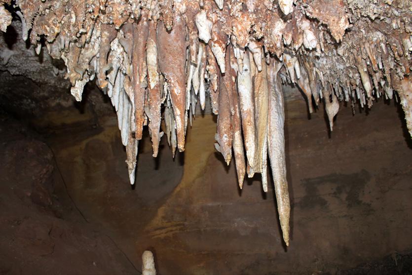

Right: These incipient stalactites clearly trace the crosscutting fractures that deliver the calcium carbonate saturated water to the cave. If I had to wager, I would bet these fractures are oriented N-S and ENE-WSW – just like the solution enhanced passageways shown on the cave map. On the right, one stalactite has mated with a stalagmite to form a column and two other pairs are almost there. Or, is the one on the far right already complete?
Left: Zoom in to a radiating, acicular cluster of minerals on the cave ceiling. Calcite? Gypsum? Something else? What do you think it is? The cluster is about 3 inches across.

Vol. 73, No. 6 | www.rmag.org 49 OUTCROP | June 2024
MANITOU SPRINGS
ON THE ROCKS:
attractions. Check out the Cave of the Winds website for more info on all these thrill-seeker opportunities (https://caveofthewinds.com/).
Our cave tour was split into 2 groups to make it easier to pass through the restricted space while minimizing interference with the normal Saturday tour traffic. Each group was to take about an hour in the cave proper. The 1st group of geologists to enter the cave was smaller in number. While Group 1 was escorted through the cave by Mark Maslyn and Rick Rhinehart, Group 2 retired to the far SE porch to listen to Harvey DuChene speak about the significance of tectonics on cave formation. Next, Harvey compared the CO2-driven formation of Cave of the Winds to the CO2 - then H2S (sulfuric acid) - driven speleogenesis in the caves of SE New Mexico and West Texas. Harvey has extensive experience with the cave systems in the Guadalupe Mountains region, including an astonishingly large number of expeditions to Lechuguilla, among the most celebrated (and decorated) caves in the world.
The 2nd group of geologists to tour the cave was larger in number than the 1st group. We toured through the main passageways, marked in green on the cave map. I was at the end of the group, accommodating my penchant for collecting photographs. This put me in a poor position to hear what the trip leaders were saying at the pauses along the tour. Afterwards, I did investigate published details of cave formation, hoping to make up for my lack of attention in the cave. It is a rich story.
The timing of cave formation is thought to range from ~4.5 Ma to ~1.5 Ma based on magnetostratigraphy of cave sediments calibrated by amino acid racemization of snail shell organic matter in a 2 Ma alluvial terrace deposited by ancestral Fountain Creek. The terrace gravels, known as the Nussbaum Alluvium or Pediment Gravel 4 (QTg4), is 200m (>600’) above the present elevation of Fountain Creek. Two million years ago (2 Ma), Williams Canyon had not yet formed. Fountain Creek was more than 600 feet above its present elevation. The groundwater flow system discharging into ancestral Fountain Creek – and dissolving the passageways of Cave of the Winds in the process - was probably very much like the subterranean plumbing system of Manitou Springs today. This included multiple groundwater flow cells mixing in a
zone beneath the (then) much higher Fountain Creek. Groundwater flow through the subsurface, at this time (2 Ma), was actively dissolving the Manitou Limestone in the vicinity of Cave of the Winds. As Fountain Creek chain-sawed the valley downward (probably enhanced by deglaciation), the mixing zone dropped to lower levels of the cave, eventually dropping below it entirely. While dropping in elevation, the mixing zone progressively migrated downgradient to the south. Speleothem generation followed groundwater drop at every step that created vadose (unsaturated) conditions. Continued fluvial incision of Fountain Creek and its tributaries moved the mixing zone and its cave forming corrosive groundwater discharges to their current location today, beneath the city of Manitou Springs.
ON-LINE:
• https://manitousprings.org/mineral-spring-water/
• https://mineralspringsfoundation.org/
• https://mineralspringsfoundation.org/ wp-content/uploads/2023/03/Mineral-Content-Chart-2022.pdf
• https://caveofthewinds.com/
• https://karstwaters.org/publications/ kwi-special-publications/
• https://nckri.org/
REFERENCES
Luiszer, Fred G., 2009, Speleogenesis of Cave of the Winds, Manitou Springs, Colorado, in Engel, Annette Summers and Scott A. Engel, eds. Select Field Guides to Cave and Karst Lands of the United States, Karst Waters Institute Special Publication 15, p. 119-132. https://karstwaters.org/wp-content/uploads/2023/06/SP15-Field-Guides.pdf
Luiszer, Fred G. (2007) Timing of Passage Development and Sedimentation in Cave of the Winds, Manitou Springs, Colorado USA, Time in Karst, Postojna,2007, 157-171. https://ojs.zrcsazu.si/carsologica/article/view/218/207 Shoemaker, John & Associates, 2011, Studies Relating to the Mineral Springs, Manitou Springs, Colorado. https://mineralspringsfoundation. org/wp-content/uploads/2023/03/Mineral-Springs-Study.pdf
OUTCROP | June 2024 50 Vol. 73, No. 6 | www.rmag.org
ON THE ROCKS: MANITOU SPRINGS
geologic

Why contribute?
Why contribute?
• Reach
• Quarterly
• Permanent
Entire greater Rocky Mountain West Texas and New Mexico to -Continent
Expanded geologic focus:
Expanded geologic focus:
• Quick
• Every
• Entire greater Rocky Mountain area of North America
• West Texas and New Mexico to northern British Columbia
• Entire greater Rocky Mountain area of North America
• Reach a broad industry and academic audience
• Great Plains and Mid-Continent region
• West Texas and New Mexico to northern British Columbia
• Quarterly peer reviewed journal
• Great Plains and Mid-Continent region Why contribute?
• Permanent archiving includes AAPG Datapages
• Reach a broad industry and academic audience
• Quarterly peer-reviewed journal
• Quick turn around time
• Every subdiscipline in the geosciences
• Quick turn-around time
https://www.rmag.org/publications/the
• Permanent archiving includes AAPG Datapages
https://www.rmag.org/publications/the
• Every subdiscipline in the geosciences
Expanded geologic focus:
area of North America
• Entire greater Rocky Mountain area of North America
northern British Columbia region
• West Texas and New Mexico to northern British Columbia
• Great Plains and Mid Continent region

Email: mgeditor@rmag.org
https://www.rmag.org/publications/the -mountain-geologist/

Vol. 73, No. 6 | www.rmag.org 51 OUTCROP | June 2024 Expanded
Publish with…
focus:
Publish with…
By Ronald L. Parker
Senior Geologist, Borehole Image Specialists, P. O. Box 221724, Denver CO 80222 ron@bhigeo.com

CELADONITE

Green, vesicle-filling celadonite with white and tan zeolites and elongate laths of plagioclase in a weathered latite from the Treasure Falls locality on the W side of Wolf Creek Pass, Mineral County, Colorado. Field of view is ~10 cm across. Photo by Ronald L. Parker.
MINERAL OF THE QUARTER
Hydrothermal Green Mica
Celadonite, K(Mg,Fe2+)(Fe3+,Al)Si4O10(OH)2, is an uncommon, dark-green dioctahedral mica that is found as fracture coatings and vesicle fillings in mafic igneous rocks. Celadonite is a monoclinic phyllosilicate that does not resemble other micas; it has microscopic crystals and a dull, earthy or waxy luster. Celadonite resembles its cousin, glauconite, in its physical, chemical and mineralogical characteristics, but forms in volcanic settings, not marine sediments. Celadonite is noteworthy because of its bright to dark green color, a feature that led to its use in “terre verte”, a pigment popular in artistic and cultural applications for millennia.
On a recent trip from Denver to Durango, I decided to have a look at some of the rocks along CO-160 at Wolf Creek Pass. I was remembering a long ago stop on the west side of the pass to relieve overheated brakes. I was leading a month-long field trip in May of 2004 for undergraduates at Earlham College. At the pullover, my students were all very impressed by blocks of weathered basalt pervaded by amygdules containing a diverse assemblage of zeolites and chalcedony along with fracture surfaces coated with a striking green mineral. Almost exactly 20 years to the day later, I pulled over to the same place. This wide pull-off, on the right (W) side of CO-160, is about 1.35 miles downhill from the hairpin turn at the Scenic Overlook (see map). The pull-off is also ~0.4 miles uphill (N) of the Treasure Falls Parking Lot. After moving my car far from the travelled lanes, I looked over the scattering of rocks and was immediately impressed by the abundance of eye-popping dark green minerals peeking out of the weathered rocks. I was intrigued! I poked around for about an hour, took some pictures, collected some hand samples and went on my way.
When I got back home, I looked up the Wolf Creek locality on Mindat and discovered that this exact spot is described in an article in Rocks & Minerals (Hampson, 2004). From the article, I learned that the rocks I encountered were probably the Conejos Formation of the Potosi Volcanic Series, comprised mostly of Quartz Latite (not basalt). I also arrived at the conclusion that the green mineral that dazzled me so was probably celadonite. Because I had scarcely ever heard of celadonite, I decided to find

Celadonite-bearing boulder taken on the 2004 Earlham Geology May Term Field Trip stop at Wolf Creek Pass, Mineral County, Colorado. Human appendages for scale. Photo by Ronald L. Parker.
out more about it and that’s the “why” of this article. Odin et. al., (1988) provide a colorful rendition of the origins of the name celadonite. So colorful, I quote it here.
“The word celadonite comes from Celadon which was the name of a warrior in “The metamorphoses” by Ovide [sic]. The original meaning was: the noisy, the resounding. The Celadon was popularized by Honoré d’Urfé in his famous 16th century pastoral novel “L’Astrée”. In this novel, Celadon was a neoplatonic lover whose clothes were adorned with green ribbons. At the time this novel was published, the first Chinese porcelains were imported into France. This porcelain was an unknown pale-green and the colour was immediately named “celadon” (like the porcelain itself) by the French court after the fashionable hero. Therefore, in French, celadon means a soft-green colour which is slightly bluish.” (p. 337).
Vol. 73, No. 6 | www.rmag.org 53 OUTCROP | June 2024
OF THE QUARTER:
MINERAL
CELADONITE
I now know that celadonite is a dioctahedral phyllosilicate, a mica that doesn’t display the standard sparkly personality. Instead, it appears with a dull, earthy or waxy luster that conceals it’s micaceousness. Like all micas, celadonite is soft, with a hardness of 2 to 2.5. Celadonite has one perfect cleavage on (001), but because crystals are almost always microscopic, this character is almost never observed. Celadonite is monoclinic (2/m) and euhedral crystals are almost unknown. The most obvious physical property of celadonite is its color, which ranges from a light apple green to dark forest green to dark blue-green.
Celadonite is a 2:1 phyllosilicate with sheets of silica tetrahedra (T) sandwiching an octahedral sheet (O). The octahedral sheet contains Fe, Mg and Al bonded to oxygen and hydroxyl groups. Isomorphic cation substitution in both the tetrahedral and the octahedral layers is common in celadonite (and other dioctahedral micas). The T-O-T arrangement is common in micas and clay minerals and the mix of cations with differing valences in the octahedral sheet leads to charge imbalances that are mitigated by potassium (K+) in the interlayer between TOT packets. The dioctahedral character is the result of the prevalence of +3 cations, (trioctahedral micas are dominated by +2 cations). One notable feature of celadonite is that it possesses both reduced (Fe2+) and oxidized (Fe3+) iron. This likely reflects variable redox conditions in the hydrothermal fluids that altered the primary minerals (olivines, pyroxenes, amphiboles, etc.) that led to authigenic celadonite.

Celadonite is similar in many ways to the finely crystalline green mica glauconite (K,Na)(Fe3+,Al, Fe2+,Mg)2(Si, Al)4O10(OH)2. Glauconite shares the color palette of celadonite with identical hardness, cleavage and luster. Like celadonite, glauconite rarely exceeds microscopic crystals and it also incorporates both oxidized (Fe3+) and reduced (Fe2+) iron in its octahedral layers. In fact, there are many ways in which
the similarities between the two have made it difficult to differentiate them, suggesting the possibility of a solid solution (Duplay and Buatier, 1990). The most important difference is mode of occurrence. Glauconite is most often found as small, rounded pellets in clastic marine sediments deposited under stable, but low, redox conditions. Celadonite is primarily found as a secondary mineral infilling vesicles in extrusive mafic igneous rocks (Nesse, 2004). Although a small proportion of celadonites are noted from sedimentary rocks, these are mostly derived from tuffaceous or volcanogenic sources.
Celadonite is most commonly reported from low-temperature (<120°C), hydrothermally-altered
OUTCROP | June 2024 54 Vol. 73, No. 6 | www.rmag.org
MINERAL OF THE QUARTER: CELADONITE
Map showing the pull-off on the south side of Wolf Creek Pass that was the place I encountered a puzzling green mineral. The outcrop photo (next picture) is across CO-160 from the pull-off.

Above: Outcrop across CO-160 from the pull-off at the Treasure Falls locality. The weathered Conejos Quartz Latite, above the light-colored tuffaceous material is the probable source of the celadonite-bearing amygdules.
Below: Celadonite, occurring as both a fracture surface coating and as vesicle fill from the Treasure Falls locality, Wolf Creek Pass, Mineral County, Colorado. The rock fragment is ~18” in long dimension. Photo by Ronald L. Parker.

Vol. 73, No. 6 | www.rmag.org 55 OUTCROP | June 2024 MINERAL OF THE QUARTER: CELADONITE
mafic volcanic rocks, both those in marine and terrestrial settings. In fact, celadonite became more frequently observed by the scientific community with an increase in deep-sea drill cores recovering volcanic rocks (Odin, et. al., 1988). Quinteiro et. al. (2021) state that “Celadonite is the most abundant K-rich hydrated mineral formed during basalt alteration.” Zhang and Smith-Duque (2014) report that seawater alteration of young oceanic basalts in the South Pacific is rapid (within a few Ma) and that celadonite is repeatedly among the earliest phases to appear (along with Fe-oxyhydroxides) followed in time by saponite, zeolites, silicates and calcium carbonate. In the rocks that I observed below Wolf Creek Pass, green celadonite was commonly seen as an early vesicle coating, sometimes – but not always – filled with later zeolites or chalcedony.
Although celadonite forms rapidly, geologically speaking, it also is known to enjoy longevity. Celadonite measured from three depth horizons in the North Shore Volcanic Group of the Mid-Continent Rift were dated by conventional K/Ar by Schmidt et. al., (2021). The celadonite ages at 3 three depths provided a picture of the post-eruptive thermal history and the ages (1062± 16Ma, 1039.4± 14Ma and 955± 12Ma) indicate hydrothermal alteration under burial conditions for more than 100Ma.
It is the intense color of celadonite that drew my attention at Wolf Creek. No surprise, I am not the first sapient to pay attention to celadonite. The intensity of the green color of celadonite has contributed to its use as a pigment in artwork, paintings, frescos, and other cultural applications, since antiquity. Along with its cousin glauconite, celadonite has long been referred to as terra verte (green earth) for use as a pigment. Celadonite has been mined for centuries from quarries near Verona, Italy and from the Troodos Massif in Cyprus (Odin et. al., 1988; Hradil et. al., 2020).
Mineral associations with celadonite include montmorillonite, nontronite, heulandite, laumontite, stilbite, apophyllite, prehnite, clinoptilolite, chlorite, quartz, calcite and many others. Celadonite is comparatively famous as a mineral inclusion that changes the color of euhedral crystals of associated minerals like quartz, calcite, apophyllite, heulandite, etc. I possess a euhedral cluster of clear quartz

microcrystals of celadonite in the crevices between the quartz crystals. Grand Reef Mine, Aravaipa District, Graham County, Arizona. The Linarite is ~12 mm across. Used with permission from John Betts Fine Minerals. http://www.johnbetts-fineminerals.com/
from Arkansas that is colored light green by celadonite - these appear as phantoms within the otherwise transparent crystals.
Important localities for celadonite include Mount Baldo, near Verona, Venetia, Italy; Zillertal, Tyrol, Austria, the Troodos Massif in Cyprus, the Triassic External Hellenides of Western Greece; Scuir Mohr, Scotland, the Faeroe Islands, the Pearl Islands, Nicaragua; many places in Japan, and many of the large flood basalt provinces of the world, including the Deccan Traps in Maharashtra, India and the Columbia Plateau in Washington and Oregon.
And… Wolf Creek Pass!
WEBLINKS:
• https://en.wikipedia.org/wiki/Celadonite
• https://www.mindat.org/min-926.html
• ttps://www.handbookofmineralogy.org/pdfs/celadonite.pdf
• https://www.webmineral.com/data/Caledonite. shtml
OUTCROP | June 2024 56 Vol. 73, No. 6 | www.rmag.org
MINERAL OF THE QUARTER: CELADONITE
Vivid blue linarite coating milky quartz crystal matrix with green

Above: Zoom-in of a small pebble I collected from the Treasure Falls – Wolf Creek Pass locality that shows some of the astonishing features that caught my attention there. There are open vesicles, vesicles with a thin rind of celadonite or nontronite, completely filled vesicles (amygdules) and broken amygdules that reveal multiple mineral phases. The white material is either chalcedony or zeolites. Note that the large vesicle at left center has an early rim of celadonite that was later filled with the white mineral. The vibrant blue amygdule in the upper-center left is 2 mm x 1.5 mm. Mineral County, Colorado. Photo by Ronald L. Parker.

Left: Translucent calcite crystals with green celadonite microcrystalline coating. The calcite crystals are scalenohedra (dog tooth spar). Castelinho Mine, near Frederico Westphalen, Alto Uruguai, Rio Grandedo Sul, Brazils. 18 cm in long dimension. Used with permission from John Betts Fine Minerals.
Vol. 73, No. 6 | www.rmag.org 57 OUTCROP | June 2024 MINERAL OF THE QUARTER: CELADONITE
REFERENCES:
Anthony, John W., Richard Bideaux and Kenneth Bladh, “Celadonite” (PDF). Handbook of Mineralogy. Chantilly, VA: Mineralogical Society of America. p. 333. Retrieved May 3 rd, 2024.
Duplay, J. and M. Buatier, 1990, The Problem of Differentiation of Glauconite and Celadonite, Geochemistry of the Earth’s Surface and of Mineral Formation, 2 nd International Symposium, Aix en Provence, France, July 2-8, 199, pp. 264-266.
Hampson, Arnold G., 2004, Zeolites and Associated Minerals of the Wolf Creek Pass Area, Mineral and Archuleta Counties, Colorado. Rocks & Minerals, 75(5):316-324
Hradil, David, Janka Hradilova and Petr Bezdicka, 2020, Clay Minerals in European Painting of the Mediaeval and Baroque Periods, Minerals, 10:255 http://dx.doi.org/10.3390/min10030255
Nesse, William D., 2004, Introduction to Optical Mineralogy, 3 rd Edition: New York: Oxford University Press, 348 pp.
Odin, G.S., A. Desprairies, P.D. Fullager, H. Bellon, A. Decarreau, F. Frohlich, and M. Zelvelder, (1988), Nature and Geological Significance of Celadonite, Chapter D in Green Marine Clays, G.S. Odin, ed., Developments in Sedimentology, Volume 45 Elsevier, New York, pp. 337-398.
Odom, I. Edgar, 1984, Glauconite and Celadonite
Minerals, Mineralogical Society of America Reviews in Mineralogy, 13: 545-584.
Quinteiro, R.V.S., R.V. Conceicao, L.C. Carniel, F.P. Leitzke, J.B.M. Cunha, M. R. Soua and M. E. B. Gomes, 2021, The Role of Celadonite on Mantle Metasomatism in Subduction Settings, Applied Clay Science, 202:1 https://doi.org/10.1016/j. clay.2020.105951
Schnmidt, Susanne Theodora, Annette Sussenberger and Klaus Wemmer, 2021, Posteruptive Thermal History of the Proterozoic Basaltic North Shore Volcanic Group of the Mid-Continent Rift: Evidence from K/Ar Data of Celadonite, Lithosphere, 18 pp. https://doi. org/10.2113/2021/8836546
Singh, Pragya, Santanu Banerjee, Tathagata Roy Choudury, Satadru Bhattacharya and Kanchan Pande, 2023, Distinguishing Celadonite from Glauconite for Environemental Interpretations: A Review, Journal of Paleogeography, 12(2): 179-194. https://doi.org/10.1016/j. jop.2023.02.001
Zhang, Guo-Liang, and Christopher SmithDuque, (2014) Seaflror Basalt Alteration and Chemical Change in the Ultra Thinly Sedimented South Pacific, Geochemistry, Geophysics, Geosystems, 15:3066-3080. https:// doi:10.1002/2013GC005141
OUTCROP | June 2024 58 Vol. 73, No. 6 | www.rmag.org
MINERAL OF THE QUARTER: CELADONITE
JUNE 5, 2024
RMAG Luncheon. Speaker: Peter Vrolijk, Talk Title: “Massive Earthquakes and Tsunamis- Contributing Factors Revealed by IODP Exp. 362.” In Person or Online. Denver Earth Resources Library, 730 17th Street, B1, Denver.
JUNE 6, 2024
WOGA Golf Clinic. Broken Tee Golf Course, 2101 W Oxford Ave., Englewood, CO. 5PM.
JUNE 8, 2024
RMAG On the Rocks Field Trip. Trip Leader: Sharon Milito. Red Rock Canyon Open Space. Manitou Springs, CO.
JUNE 14, 2024
Denver Petroleum Club Family BBQ. 3:00- 7:00 PM. City Park Pavillion. 2001 Steele Street, Denver, CO. denverpetroleumclub.com for tickets.
JUNE 29, 2024
RMAG On the Rocks Field Trip. Trip Leaders: Jon Stone and Lou Taylor. Geology and Paleontology of the Canyon City Area.

OUTCROP ADVERTISING RATES
Vol. 73, No. 6 | www.rmag.org 59 OUTCROP | June 2024
IN THE PIPELINE 1 Time 2 Times 6 Times 12 Times Full page (7-1/2” x 9-1/4”) $350 $650 $1,800 $3,400 2/3 page (4-7/8” x 9-1/4”) $250 $465 $1,290 $2,430 1/2 page (7-1/2” x 4-5/8”) $200 $370 $1,030 $1,950 1/3 page horizontal (4-7/8” x 4-7/8”) $175 $325 $900 $1,700 1/3 page vertical (2-3/8” x 9-1/4”) $175 $325 $900 $1,700 1/6 page (2-3/8” x 4-7/8”) $100 $185 $520 $970 Professional Card (2-5/8” x 1-1/2”) $30 $55 $155 $290
WELCOME NEW RMAG MEMBERS!
Geoffrey Mibei is with NREL from Golden, Colorado
Logan Douglass is a Student Member
Kat Goodman is with BPX Energy from Firestone, Colorado
Tom Cummings is with the Bureau of Land Management from Meeker, Colorado
Matt Boyce is with Seispetro from Arvada, Colorado
Michael Anderson is from Wheatland, Wyoming
Jay Leaver is with Truleum, Inc. from Buena Vista, Colorado
Danielle Kyle is with Red Willow Production Company from Durango, Colorado
Susan Marriott is from Denver, Colorado
Sarah Heger is with GMT Exploration from Conifer, Colorado
Dan Murray is from Denver, Colorado
Liam Posovich is a Student Member at Colorado Mesa Univeristy
Emma Revenaugh is a Student Member at Colorado Mesa Univeristy
Cody Craig is a Student Member at Adams State University
Lauren Linneman is a Student Member at Western Colorado University
Kajsa Holland-Goon is a Student Member at Colorado State University
Elizabeth Weyl is a Student Member at the Colorado School of Mines
Shandon Miller is a Student Member at the University of Northern Colorado
Luke Nesmith is a Student Member at Fort Lewis College
Sydney Ciechanowicz is a Student Member at the University of Colorado
OUTCROP | June 2024 60 Vol. 73, No. 6 | www.rmag.org
CALENDAR – JUNE 2024
Vol. 73, No. 6 | www.rmag.org 61 OUTCROP | June 2024 •Confluence Resources 39 •Donovan Brothers 26 •Larson Geoscience 26 •LMKR Gverse Geographix ....................................................................................... 14 •M.D. Lewan, Ph.D.................................................................................................... 45 •Sproule 45 •Tracerco 10 ADVERTISER INDEX
SUNDAY MONDAY TUESDAY WEDNESDAY THURSDAY FRIDAY SATURDAY 2 9 16 23 30 3 10 17 24 4 11 18 25 5 12 19 26 6 13 20 27 7 14 21 28 1 8 15 22 29
RMAG Luncheon. WOGA Golf Clinic. Denver Petroleum Club Family BBQ.
RMAG On the Rocks Field Trip.
RMAG On the Rocks Field Trip.