

OUTCROP
Newsletter of the Rocky Mountain Association of Geologists


OUTCROP
Newsletter of the Rocky Mountain Association of Geologists
730 17th Street, B1, Denver, CO 80202 • 720-672-9898
The Rocky Mountain Association of Geologists (RMAG) is a nonprofit organization whose purposes are to promote interest in geology and allied sciences and their practical application, to foster scientific research and to encourage fellowship and cooperation among its members. The Outcrop is a monthly publication of the RMAG.
2024 OFFICERS AND BOARD OF DIRECTORS RMAG STAFF
PRESIDENT Mike Tischer mtischer@gmail.com
PRESIDENT-ELECT Matt Bauer matthew.w.bauer.pg@gmail.com
1st VICE PRESIDENT Lisa Wolff lwolff@bayless-cos.com
1st VICE PRESIDENT-ELECT Nate La Fontaine nlafontaine@sm-energy.com
2nd VICE PRESIDENT Jason Eleson jason@geointegraconsulting.com
2nd VICE PRESIDENT-ELECT Ali Sloan ali@sloanmail.com
SECRETARY Drew Scherer flatirongeo@gmail.com
TREASURER
Holly Lindsey hrlindsey@bafatoy.com
TREASURER-ELECT
Astrid Makowitz astridmakowitz@gmail.com
COUNSELOR
Steve Crouch scrouch@whiteeagleexploration.com
ADVERTISING INFORMATION
Rates and sizes can be found on page 50. Advertising rates apply to either black and white or color ads. Submit color ads in RGB color to be compatible with web format. Borders are recommended for advertisements that comprise less than one half page. Digital files must be PC compatible submitted in png, jpg, tif, pdf or eps formats at a minimum of 300 dpi. If you have any questions, please call the RMAG office at 720-672-9898.
Ad copy, signed contract and payment must be received before advertising insertion. Contact the RMAG office for details.
DEADLINES: Ad submissions are the 1st of every month for the following month’s publication.
The Outcrop is a monthly publication of the Rocky Mountain Association of Geologists
DESIGN/LAYOUT: Nate Silva | n8silva.com
EXECUTIVE DIRECTOR
Bridget Crowther bcrowther@rmag.org
LEAD EDITOR
Nate LaFontaine nlafontaine@sm-energy.com
CONTRIBUTING EDITORS
Elijah Adeniyi elijahadeniyi@montana.edu
Marlee Cloos marlee.cloos@bpx.com
Danielle Robinson danielle.robinson@dvn.com
RMAG CODE OF CONDUCT
RMAG promotes, provides, and expects professional behavior in every engagement that members and non-members have with the organization and each other. This includes respectful and inclusive interactions free of harassment, intimidation, and discrimination during both online and in-person events, as well as any content delivered by invited speakers and instructors. Oral, written or electronic communications that contain offensive comments or demeaning images related to race, color, religion, sex, national origin, age, disability, or appearance are not appropriate in any venue or media. RMAG reminds members of the diversity and mission statements found on our website. Please direct any questions to staff@rmag.org

OUTCROP

ASSOCIATION
6
16 Lead Story: 1879– Archibald Geikie’s Field Trip To The Rocky Mountains 32 On The Rocks: Field Trip To Red Rock Canyon Open Space
RMAG 2024 Golf Tournament 25 Raft the Grand Canyon With RMAG
On-The-Rocks: Eagle Basin
On-The-Rocks: Lake City
2024 CCS Workshop
44 RMAG Foundation Receives Generous Bequest
44 2024 Recipients of the K-12 Earth Science Teacher of the Year Award
45 Consider Publishing In The Outcrop
50 Save The Date: North American Helium & Hydrogen Conference

Boulder Canyon, Colorado: A landscape painting by Archibald Geikie, 1879 (Photo courtesy of Haslemere Educational Museum, Surrey, UK).

MEMBERS
EVENT ATTENDEES
WEBSITE VISITORS
OUTCROP READERS
EMAIL SUBSCRIBERS
NETWORKING EVENTS
CONTINUING EDUCATION EVENTS
FIELD TRIPS
COMMUNITY CONTACTS IN 2023 YOUR SUMMIT SPONSORSHIP DOLLARS SUPPORTED: 1,200 2,000 8,000 8,500 5,000 3,500 30 15 9


Geoscience Community:
October 20, 2023
We greatly appreciate every Summit Sponsor and Event Sponsor that has contributed to RMAG over the last year. We could not exist without your support
The Rocky Mountain Association of Geologists celebrated a year of remarkable achievements, bringing together a global community of over 300 geologists for the Helium Conference for one of the first events exploring Helium production from exploration to processing. Monthly Women's Coffee, Membership Happy Hours, and thematic luncheons provided a supportive networking environment. In these gatherings, experts delved into diverse subjects, with topics that spanned from landslides to the intricate geology of the Permian Basin. RMAG also offered classes on oil and gas property valuation, enriching the skill set of members. A core workshop facilitated hands-on learning, and field trips to quarries, crater impacts and other geologic marvels ignited the spirit of exploration. Notably, the association extended its community impact through outreach at community festivals and classrooms across the Denver Metro area, emphasizing our dedication to advancing geological understanding and appreciation.
2024 brings new opportunities for RMAG Your sponsorship dollars will help RMAG bring to fruition an extensive calendar of continuing education opportunities, an exciting Field Trips season, and a dynamic list of luncheon speakers on topics ranging from the state of the industry to hydrogen and more. These dollars will allow RMAG Members impact the next generation at outreach events throughout the community and provide opportunities for the geoscience community to connect and build their network.
Your sponsorship dollars will also support our excellent publications including the monthly Outcrop newsletter and the quarterly Mountain Geologist journal We recognize your financial commitment with inperson signage, and website and publication advertising, as well as through social media before each online event. With a LinkedIn group of almost 3000 members, we make our sponsors visible to the geoscience community for both virtual and in person events
Thank you to those who are already a Summit Sponsor, we look forward to your continued support in 2024. If you are not already a sponsor, please look at the many complementary benefits included with the sponsorship levels. If our annual sponsorships don't make sense for your company, or you want to sponsor something specific, ask about our single event sponsorship opportunities. Please feel free to contact our staff with questions about sponsorship by email: bcrowther@ rmag.org or by phone at 720-672-9898 ext. 102
We and the staff of RMAG thank you all for your continued support and look forward to seeing you in 2024.
Michael Tischer
Bridget Crowther 2024 RMAG President RMAG Executive Director


12
Registration points are c u m u
and can be used for Symposiums or Short Courses. For example a
Sponsor can send 4 people to the 2023 North American Helium Symposium, and register for 4 short courses.
Registration Points are c u m u l a t i v e and can be used for any social event. For example, 1 point means 1 golfer, or 1 registration for Rockbusters. *2 points can be used for a golf hole if that makes more sense for your company.
Registration Points are cumulative for luncheons or one day field trips.
Luncheon & Field Trip Tickets
For all event tickets please contact the RMAG office at staff@rmag.org to use your spots.
RMAG 2024 SUMMIT SPONSORSHIP
All sponsor benefits event tickets follow RMAG event registration deadlines. All benefits end 12 months after registration.
RMAG 2024 ANNUAL SUMMIT SPONSOR OPPORTUNITIES
Platinum Sponsor Gold Sponsor
Silver Sponsor
Summit Sponsorship benefit term is for 12 months! Specify type of payment on signed form, and send logo and advertisements to staff@rmag.org
Company:
Company Representative:
Address:
City: State: Zip Code:
Phone: Email:
Payment Method: Credit Card ACH Check
Credit Card Information: Select Card: AMEX Mastercard VISA Discover
Name as it appears on Credit Card:
Credit Card #:
Expiration Date: Security Code:
Signature:
ACH: contact the RMAG office at staff@rmag.or for directions
Mail Checks payable to RMAG:
Rocky Mountain Association of Geologists (RMAG)
730 17th Street, B1 Denver, CO 80202
RMAG events are subject to change. Cancellation or rescheduling of events does not give the sponsor the right to refund. Summit Sponsors will receive benefits at any new events added into the RMAG schedule.
Thank you for your generous support!
P: (720)672-9898 staff@rmag.org www.rmag.org

730 17th Street, B1 Denver, CO 80202
PRESIDENT’S LETTER
By Mike Tischer
Geology At The Movies
Dear RMAG Members,
Do you think geologists are the coolest scientists out there? I do. We can be really nerdy but we also know how to party. We are the perfect combination of the professor who works in their lab 7 days a week and the adventurer who is traveling to faraway places to unravel the mysteries of the Earth. Pretty cool, I’d say! Unfortunately, that doesn’t always come across to the public. Being a geologist, or any scientist really, is not as sexy as being a medical doctor, a police officer, or even a lawyer. Just look at the shows on TV, can you name one that has a geologist in a leading role? Yep, there aren’t any. But it gets worse. Arguably the most nerdy, pro-science show on TV over the last decade, The Big Bang Theory, has one of their main characters, Sheldon Cooper, constantly making fun of us. Here is an example:
“Interesting fact: In the field of geology, ‘geology’ actually means ‘boring.’”
—Sheldon
Cooper, The Big Bang Theory, S5Ep15
Ouch!
But not all hope is lost. Our standing in the world is a bit better when it comes to the movies. There are plenty of motion pictures that feature a geologist. In some of them, our profession even does heroic things and sometimes (gasp!) saves the planet. That’s the spirit!
Since it’s summer, let’s take a look at some of the best (and worst) examples of geology and geologist as portrayed on the silver screen. My hope is to provide you, dear reader, with some relief during those long and hot summer nights. Some of these screen gems you may know, others might be new to you. All of them are worth watching (although for some you may want to watch with alcohol on hand, lots of it; just saying).

Before we dive into the crème de la crème of geology-themed movies, some general remarks to set the stage:
• In general, most movies that feature geologists are disaster movies, period. That’s just the way it is. Don’t fight it. Actually, it’s good when you think about it. Some of these movies became huge blockbusters introducing geology to many people. Plus, in these movies, we can be the hero. Most medical shows involve a hospital, law shows need a
Movie poster for 1974’s Earthquake.


courtroom, and geologists, well, we need something that is about to blow up, erupt, flood, break apart –you get the picture.
• We are not going to talk about Jurassic Park or the Jurassic World franchise or any other movie that prominently features dinosaurs. Yes, I know, the Jurassic movies have probably done more than any other motion picture to excite the general populace about geology, and that’s exactly why we can’t talk about them here, unless you want me to fill up the entire Outcrop issue. Sorry to all paleontologists out there, we love you!
• Finally, when you look at the movies that prominently feature geology or a geologist as part of the story, several categories become apparent. The big ones are: volcanoes, earthquakes, climate change, asteroid impacts, dinosaurs. I’m going to focus on the first two and mostly skip the rest. Again, this is a president’s letter and not a master’s thesis. Space and time are at a premium.
With this in mind, let’s get started with volcanoes. In 1997, when I did my masters at SUNY Buffalo, there were two high profile movies released that featured geologists in main roles. One was Dante’s Peak, featuring Pierce Brosnan as a vulcanologist discovering that the long-dormant volcano near a small town in the Pacific Northwest showed signs of imminent eruption. The other one was Volcano, featuring Anne Heche as a seismologist helping city officials in L.A. save lives after a massive volcanic eruption. At the time the movies came out I was just starting my geology career so I didn’t really know much about the science behind these movies. Fortunately, the geology department at
SUNY Buffalo had a thriving and well-known volcanology group and so I tagged along to the theater with them. Their verdict: Dante’s Peak is mostly accurate but the timeline of the geological events shown was way too short. And what about Volcano? Well, garbage really. A Hawaiian-style volcanic eruption in LA? Give me a break! In any case, we are not here to condemn movies solely on their scientific accuracy. If that would be the main criteria you would be better off watching documentaries. Both of these movies are entertaining and as long as you suspend disbelief you will enjoy them. If you like Volcano and can’t get enough of magma flowing through big cities, I can also recommend Eruption: LA, Miami Magma and Disaster Zone: Volcano in New York. Apparently, there is a big volcano underneath every big city in the US just waiting to erupt. I had no idea! FYI, none of these got more than 3.5 out of 10 stars on IMDB, so watch at your own risk.
Let’s move on to earthquakes and see what we have there. Hollywood has been fascinated with earthquakes for a long time. The Night the World Exploded (what a great title!) from 1957 features a computer that predicts a big earthquake that will destroy the world in 28 days. Or 1974’s classic Earthquake, which features a star-studded cast but unfortunately no geologist (see image). That one takes place in LA again (that city can’t catch a break, apparently). I remember watching this on TV when I was growing up. Back then, I watched everything that was tagged as a ‘disaster’ movie. Still do! More recently, we got a few that are concerned with the Big One: 10.0 Earthquake (2014) and 10.5 Apocalypse (2006). I’m now waiting for one that goes all the way to 11 and beyond. One of the more popular ones in this subgenre in recent years

is San Andreas (2015). When I heard that The Rock was starring in it, I was hoping he would be the geologist, but alas, we were not that lucky. Instead, we had Paul Giamatti as the voice of reason playing a seismologist at Caltech. Not bad! Look for Earthquake movies on IMDB and you’ll find enough to keep you busy for a week straight.
I mentioned already that I will skip some big categories here. Dinosaurs and Climate Change. The latter has a whole post-apocalyptic sub-genre that deals with the aftermath of a climate catastrophe. There goes another week of watching movies. However, I do have a couple of honorable mentions, if you’ll allow me – then we will move on to the ultimate geology movie
My first honorable mention is a Norwegian movie from 2015 called The Wave. I like it because it’s not Hollywood run-of-the-mill stuff, has a geologist as the hero and actually deals with a geological disaster that’s not usually featured prominently in this genre–a landslide. Check it out! My second pick is for those of you who can’t decide if they like volcanic eruptions, earthquakes, falling rocks from the sky, or tsunamis better. Why not have it all? Watch Roland Emmerich’s 2012, that movie has it all and therefore is completely over the top. Great entertainment if you are into fantasy.
Alright then, I’m almost done and the only thing that’s left to mention is the mother of all geology disaster movies. This one is so bad, it’s good. It has achieved cult status among the geoscience community. I’m of course talking about The Core from 2003. In it, a team of scientists and astronauts, including a geophysicist, are travelling to the Earth’s core that has stopped spinning. What a great premise! Of course, there are so many geologic inaccuracies in this movie that every time I watch it, I’m not sure if I should
cry, yell at the screen or laugh uncontrollably. As I said, it’s a cult classic. I think everybody should watch The Core at least once a year.
I could go on but I’m going to stop here. Hopefully, I’ve provided you with some ideas on how to spend, those late summer nights. Don’t forget the soda and the popcorn. In the meantime, while we all wait for the next, great geoscience disaster movie to hit the theater, why not take a look at this issue of the Outcrop? In here, you will discover some other exciting geoscience stories, I promise.
Enjoy the rest of the summer!
P.S.: If you made it this far, Congratulations! I’m curious to hear what your go-to geology movie is. What are your favorite flicks to watch? Which ones can you not stand? Feel free to drop me a note at president@ rmag.org. I can share with everybody if we get enough feedback.


1879
Archibald Geikie’s Field Trip To The Rocky Mountains
BY RASOUL SORKHABI,
University of Utah, Salt Lake City, UT •
rsorkhabi@egi.utah.edu
This year marks the 100th anniversary of Archibald Geikie’s death. This article describes Geikie’s travel to the American West in 1879 and his writings about these field visits. The Haslemere Museum in England hosts “Sir Archibald Centennial Celebration” from 8-9 November 2024, and the author of this article presents an invited talk on “Geikie’s North American Connections.”
In 1875, Archibald Geikie, director of the Geological Survey of Scotland and professor of geology at the University of Edinburgh, published a two-part article entitled “American Geological Surveys in Nature (Geikie, 1875). Geikie briefly reported on the pioneering surveys of American geologists in the Rockies of the “Western Territories,” and remarked that the reports of these surveyors were “full of fresh illustrations of the principles of geology.” Geikie’s 1875 article was related to his keen interest in the American West, which culminated in his travels to the Rockies in 1879 – incidentally the same year the US Geological Survey formed. This historical account, given the stature of Geikie, not only illustrates
trans-Atlantic cooperation among geologists during the 19th century but also highlights the significance of the American West in the development of geology.
MAPPING THE NEW FRONTIER
The American West has epitomized the concept of New Frontier, with all its qualities of adventure and exploration as well as greed and exploitation. The Rocky Mountain region attracted immigrants, businessman, miners, ranchers, outlaws, adventurers, writers, and scientists. Mapping of this region in the second half of the 19th century was instrumental in the formation the USA as a single, continent-wide country spanning from coast to cast. Among the

FIGURE 1: Sir Archibald Geikie (1835-1924) was born and educated in Edinburgh. He rose to be one of the greatest British geologists of his time serving as the director of the Geological Survey of Scotland (1867-1881), professor of geology at Edinburgh University (1871-1881), and director of the Geological Survey of the United Kingdom in London (1882-1901). He was also a prolific author and his Textbook of Geology (first published in 1882 and fourth edition in 1905) were widely used in the UK and the USA. (Photo: Cassell’s Universal Portrait Gallery, 1895, London, p. 449).
pioneering surveyors of the American West were Clarence Rivers King (1842-1901), John Wesley Powell (1834-1902), Ferdinand Vandeveer Hayden (1829-1887), Clarence Edward Dutton (1841-1912), and Grove Karl Gilbert (1843-1918). Geikie met or corresponded with all of these great American geologists and had read their reports with a keen interest (Sorkhabi, 2109).
Geikie had two specific scientific objectives in visiting the American West: First to observe the
erosional power of rivers in shaping landscape; second to examine the widespread volcanic activity in the Yellowstone region. Both of these geologic problems were hotly debated in Europe during the 19th century and had occupied Geikie’s mind for years.
The first problem was whether erosion was powerful enough to create the ups-and-downs of Earth’s topography or, as some geologists then believed, the topography essentially consisted in primitive features dating back to Earth’s creation or that they were mainly the products of a gradually cooling, collapsing earth, or of marine water action before the land surface emerged from a former ocean. Geikie was among the scientists called “erosionalists” who believed that flowing waters, moving glaciers, and blowing winds in the course of geologic time are powerful enough to shape Earth’s landforms. This was also consistent with the principle of uniformitarianism.
The second geologic question was related to the origin of widespread volcanic rocks in the British Isles and Iceland where no cone-shape volcanic mountains and craters are present. How did these volcanic rocks originate? Geikie found his answer in Wyoming and Idaho where fissures (not necessarily cones) were conduits for outpouring of huge amounts of lave to create the vast volcanic landscape.
Geikie published the results of his 1879 field trip to the American West in several articles: “On the Archaean rocks of Wahsatch Mountains,” in American Journal of Science (Geikie, 1881); two articles, “In Wyoming” and “The geysers of Yellowstone,” in Macmillan’s Magazine (Geikie, 1881a,b), which he also included as two chapters in his book Geological Sketches at Home and Abroad (Geikie 1882); “Ancient glaciers of Rocky Mountains,” in American Naturalist (Geikie, 1881c); and “The Cañons of the Far West” in Proceedings of Royal Institution of Great Britain (Geikie, 1882-1884). Finally, he described his American travels in his autobiography A Long Life’s Work: An Autobiography (Geikie, 1924). The quotations from Geikie below come from the Geological Sketches.
GOING WEST
In his field trip to the American West, Geikie was accompanied by Henry Drummond, his former
student (“Geology Class of 1871”) at the University of Edinburgh, who, two years before the American trip, had become a lecturer in natural science at the New College of the Free Church of Scotland in Glasgow where he was also trained as an evangelist minister.
Geikie and Drummond boarded the ship to the New World on July 31, 1879. Upon arrival in New York, they were received by F. V. Hayden, who arranged for them letters of recommendation from the Secretary of War to the resident military officers in the “Far West” to show hospitality and assistance to the Scottish geologists. On August 1, Geikie and Drummond were in a Pullman railroad car passing the blue waters of the Hudson River toward Chicago. “A project which had been little more than a dream for many years,” Geikie wrote, “was now at least actually realized.”

At Chicago they transferred to the Union Pacific train. They crossed the Mississippi and Missouri rivers heading west: “At last, on the far western horizon the first summits of the Rocky Mountains rose like blue islets out of the sea.” They had reached the Front Range in Colorado with views of snowcapped peaks.
The core of the Rockies, like many other mountain ranges, is made of granitic and metamorphic rocks deeply rooted in the Earth’s crust. Geikie relates this geologic structure to mining in Colorado: “The rise of the granitic axis has brought up with it that incredible mineral wealth which, in a few years,
has converted the loneliest mountain solitudes into busy hives of industry.” They stopped in Denver and in the gold-mining towns of Golden and Boulder; they visited the Boulder Canyon on the Colorado River. Geikie did some landscape paintings of these places.
WYOMING
Boarding the Union Pacific again, Geikie and Drummond left Colorado for Wyoming. Geikie remarks that the north-south running rugged “Rocky” Mountains are in no way a continuous colossal range but sinks into lowlands here and there. As an example, he mentions Laramie Plains. At Cheyenne, the train turned west and they eventually reached Fort Bridger in southwest Wyoming where a famous local man, Judge Carter, was their host. Carter took his
FIGURE 2: Sir Archibald Geikie’s geologist’ hammer (photo by R. Sorkhabi at Haslemere Educational Museum, Surrey, UK.)
IDAHO
WYOMING
COLORADO UTAH
FIGURE 3: A map showing travel routes of Sir Archibald Geikie in 1879 to the US Rock Mountain States with major stops. The inset map is for the Yellowstone National Park (map drawn by the author of this article).
guests to see the “Bad Lands” of southern Wyoming (along today’s Interstate 80) – “tracts of irreclaimable barrenness, blasted and left for ever lifeless and hideous.” He reports the day-time temperatures to be as high as 90° F in the shade while at night temperature falls down to 19° F.
From their base at Fort Bridger, Geikie and Drummond (together with a guide named Dan) made an excursion into the Uinta Mountains – “one of the most interesting ranges in North America; for, instead of following the usual north and south direction, it turns nearly east and west, and, in place of a central crystalline wedge driven through the younger formations, it consists of a vast flat arch of nearly horizontal strata that plunge steeply down into
the plains on either side … The broad central mass of the range is constructed of a flat arch of dullred sandstone.”
Geikie’s party climbed to the elevations of 12,000 feet, and in the afternoon on their way back through the forest they lost the trail. As night was already coming they found an open space where they made a camp fire and went out to look for fresh water. On their return, they were stunned to see that the fire had spread to the surrounding pine trees. Luckily, there was no wind, and by the morning the flames had died down. They returned to Fort Bridger that day.
Denver
Laramie
Cheyenne
Fort Bridger
SLC
Odgen
Fort Ellis
Bozeman
MONTANA
Unita Mts Wasatch
Great Salt Lake Yellowstone National Park (Inset Map)
Old Faithful

4: Geikie’s painting of “Noahville” (local name for a small settlement) between Golden and Denver (Photo courtesy of Haslemere Educational Museum, Surrey, UK).

FIGURE
FIGURE 5: Geikie’s painting of Boulder Canyon, Colorado (Photo courtesy of Haslemere Educational Museum, Surrey, UK).
SALT LAKE VALLEY
They took the Union Pacific train at Ogden Junction to reach Salt Lake City, where “the Mormons have converted the strip of land between the base of the heights [Wasatch] and the edge of the water [Great Salt Lake] into fertile fields and well-kept gardens.” At the hotel, Geikie met Captain Clarence Dutton and Major John Powell, who took the Scottish guests to visit Fort Douglas on east side of Salt Lake City (now part of the University of Utah).
Geikie and Drummond visited the Great Salt Lake and joined the swimmers who were enjoying the floatation in the highly saline waters: “It was strange to reflect that the varied beauty of the valleys in the neighbouring mountains, with their meadows, clumps of cottonwood trees, and rushing streams, should lead into the lifeless stagnant sea.”
Referring to G. K. Gilbert’s 1875 report, Geikie remarks that the Great Salt Lake was once part of a much larger former fresh-water lake – called Lake Bonneville by Gilbert – measuring about 300 miles north-south and 180 miles east-west at its greatest height of 940 feet above the present level. The lake used to have outlet into the Snake River in Idaho, draining into the Pacific Ocean. The lake became salty by excessive evaporation of its waters over time.
Geikie and Drummond also made a field trip to the Wasatch Mountains with summits covered with snow even in the month of August: “This range serves at once as the western boundary of the plateau country and as the eastern rim of the Great Basin.”
Geikie makes an interesting inference from the interface of moraine sediments in the Wasatch canyons and Bonneville’s paleo-shore line: “I further noticed at the Little Cottonwood Cañon that the moraines descend to the edge of the highest terrace, and that the glacial rubbish forms part of the alluvial deposits there. Hence, we may infer that at the time of the greatest extension of the lake the Wahsatch Mountains were a range of snow alps, from which glaciers descended to the edge of the water.”
Another important observation made by Geikie in the Wasatch Mountains is related to the age of huge granitic bodies that make up some of the
high summits in the Little and Big Cottonwood canyons. How did this massive granite form? Clarence King in his 1878 geologic report had suggested that the granitic core of the Rockies belonged to the oldest geologic time – the Archean age. The Rockies, in his interpretation, were once a very old large island, and during Paleozoic times sandstone and limestone were deposited on the sea surrounding the island. In other words, the granite was older the Paleozoic sediments.
Geikie investigated this interpretation on his field trip to the Little Cottonwood Canyon. He noticed that no pebbles of the granite are found in the Paleozoic sediments which would be the case if granite was older and the source of sediments. Geikie also observed that as we approach the granite the sediments become metamorphosed by the heating effect of the granite; sandstone has become quartzite and limestone has become white marble. Moreover, Geikie observed intrusions (dikes) of granite within the sedimentary rocks. He thus concluded that the white granite in the Wasatch Mountains was intrusive and younger than the entire Paleozoic sediments. Geikie published these observations in the American Journal of Science. In his 1882 Textbook of Geology, Geikie also repeated his interpretation in reference to the granite body in the Little Cottonwood Canyon –namely, it is “post-Carboniferous age.” (Geikie, 1882). Modern radiometric dating of the Wasatch granite has indeed assigned an Oligocene age (about 35 million years old), which marks the onset of the Basinand-Range extensional tectonics in the Great Basin.
YELLOWSTONE COUNTRY
To visit the Yellowstone region, Geikie and Drummond took a train at Ogden heading for Idaho. They stopped in the towns of Virginia and Bozeman in Montana (located along today’s Interstate 90) before reaching their destination – Fort Ellis, a U.S. Army post under the command of Quartermaster Lieutenant Alison who would be their host. Lieutenant Alison gave two guides to Geikie and Drummond for their travels in the Yellowstone Park: Jack, a trapper and miner, and Andy, a cook and in charge of the mules. Geikie was especially impressed by Andy’s outdoors skills – his cooking,
campfire stories and field experiences: “Andy, in particular, would never be outdone. Nothing marvelous was told that he could not instantly cap with something more wonderful still that had happened in his own experiences.”
In 1872, the US Congress and President Ulysses Grant designated Yellowstone as the country’s first national park (and probably the first national park in the world as well). Geikie had longed to “see the wonders of the Yellowstone – that region of geysers, mud volcanoes, hot springs and sinter-beds, which the United States Congress, with wise forethought, has set apart from settlement and reserved for this instruction of the people.” Geikie found night camping at the Yellowstone Park to be very delightful: “Wrapping myself in the buffalo-cloak, with which Quartermaster Alison had so kindly provided, I used to lie apart in the open for a while, gazing up at the deep sky, so clear, so sparkling, so utterly and almost incredibly different from the bleared cloudy expanse with which we must usually be content in Britain.” Most of Geikie’s landscape paintings during his US trip were also from Yellowstone. Moreover, Drummond’s diary of their field trip to Yellowstone is extant (Smith, 1898); it begins on September 2, the day the party left Fort Ellis and ends on September 12. Drummond’s writing, often in a telegraphic style, is full of wit. For instance, we have this entry for Monday, September 8:
“Followed trail through magnificently timbered country with parks, glades, and streamlets, then across prairie country to head of Alum Creek deposits, effluvium [from] steaming springs, sulphur mountain, Solfataras. Trail through timber again. Over the Divide. Down steep forest-clad hill to the east fork of Madison River. Fire Hole River. Through long swamp timber again. Camp in glade by river-side. Seven hours in saddle. Lunch, bathe, bear, theological discussion with Jack. Geology, volcanic all day. Obsidian blocks everywhere; schistose obsidian” (Smith, 1898).
Geikie carried F. V. Hayden’s 1871 geologic map of Yellowstone, and made his own observations as well. He describes how the Yellowstone country was shaped by both fluvial and glacial agents as evident
from the presence of rivers and creeks as well as alpine valley glaciers in the area. From the evidence of eroded valley walls with rock polished and striated by the former glaciers, Geikie estimated that the thickness of the ice in the Pleistocene age mush have been 800 to 1600 fee above the present river plain (Geikie, 1881c).
After completing their trip to Yellowstone, Geikie and Drummond said goodbye to Jack and Andy at a railway station in Idaho that had been opened a week or two before. The train would take them back to Ogden in Utah.
THE RETURN JOURNEY
Geikie and Drummond headed back to the east by train. They visited Niagara Falls and stayed for a few days in Canada. In Boston Geikie gave a series of lectures on “Geographical Evolution” at the city’s Lowell Institute (founded by John Lowell, Jr.in 1839). At the time of Geikie’s visit, the founder’s cousin, John Amory Lowell was leading the institute. Mr. Lowell invited the Scottish guests to a dinner at his residence at Brooklyn; a group of eminent scientists and artists from Boston and Cambridge were also present, including the famed geologist William Rogers. Later in his autobiography (Geikie, 1924), Geikie recalls that at dinner he was sitting between the famous poet Longfellow and a lawyer Oliver W. Holmes: “The poet was quiet at dinner … Mr. Holmes, on the other hand, was full of talk.” After returning to the UK, Geikie sent his articles in Macmillan’s Magazine to Holmes, and the latter replied that “I have read your adventures and your scientific experiences in Wyoming which you have kindly sent me. I am all ready to become an ‘Erosionalist’ under your agreeable guidance” (Geikie, 1924).
While in the east coast and before departing the US, Geikie also met with James Dwight Dana (18131895), probably the most prominent academic geologist in the USA during the 19th century. Dana took Geikie and Drummond on a day-long geological excursion.
Their last stop was Philadelphia where they spent a few days with Hayden – the geologist friend who had received them upon their arrival in New York. In his autobiography, Geikie (1924) concludes

FIGURE 6: Geikie’s painting of Smith’s Fork on the northern slope of the Uinta Mountains. The lake and mounds of glacial deposits (moraine) are seen in the painting. Smith’s Fork is today a part of the UintaWasatch-Cache National Forest (Photo courtesy of Haslemere Educational Museum, Surrey, UK).

FIGURE 7: Geikie’s painting of entrance to the American Fork Canyon, Wasatch Range, Salt Lake City. The ridge on the right is the Great Blue Limestone of Mississippian age. The high ridge on the left is the Tintic Quartzite of Cambrian age overlying the Precambrian Mutual Quartzite (front side) (Photo courtesy of Haslemere Educational Museum, Surrey, UK; photo caption by R. Sorkhabi).


FIGURE 8: Geikie’s painting of Castle Geyser, Yellowstone National Park (Photo courtesy of Haslemere Educational Museum, Surrey, UK).
FIGURE 9: Geikie’s painting of the mouth of Old Faithful Geyser, Yellowstone National Park (Photo courtesy of Haslemere Educational Museum, Surrey, UK).
his 1879 trip to the USA as follows: “After a journey by sea and land of some 15,500 miles I was back in Edinburgh before the date for the opening of the session at the University. The three months of absence were time profitably spent.”
On November 10, 1879, according to a report in Nature, “Prof. Geikie reopened the class of geology in the University of Edinburgh by giving an account of his recent exploration of the western territories of North America. There was a large attendance of students and others.” Geikie opened his lecture with these remarks:
“Had geology begun in those western territories, instead of among the old broken, and contorted rocks of Europe and the east of America, its progress, at all events in some departments, would have been far more rapid than it had been.”
ACKNOWLEDGMENTS
I would like to express my gratitude to three friends in the UK for their kind support and encouragement for my research on Sir Archibald Geikie: Dr. Jonathan Craig, Dr. John Betterton, and Ms. Julia Tanner (former Curator at Haslemere Educational Museum, Surrey, UK).
REFERENCES CITED
Geikie, A., 1875, American geological survey, Nature, August 5, 1875, 12, 265-267 and November 4, 1875, 13, 1-3.
Geikie, A., 1880, On the Archaean rocks of Wahsatch Mountains, American Journal of Science, 19, 363-367.
Geikie, A., 1881a, “In Wyoming,” Macmillan’s Magazine, 264: 229-240;
Geikie, A., 1881b, “The geysers of Yellowstone,” Macmillan’s Magazine, 264: 421-435.
Geikie, A., 1881c, “Ancient
glaciers of Rocky Mountains,” American Naturalist, 15: 1-17.
Geikie, A., 1882a, Geological Sketches at Home and Abroad, Macmillan, London.
Geikie, A., 1882b, Textbook of Geology, Macmillan, London.
Geikie, A., 1882-1884, “The Ca ñ ons of the Far West,” Proceedings of Royal Institution of Great Britain 10: 268-271.
Geikie, A., 1924, A Long Life’s Work: An Autobiography, Macmillan, London.
Smith, G. A., 1898, The Life of Henry Drummond, Doubleday & McClure Co., New York.
Sorkhabi, R., 2019, “Sir Archibald Geikie: The North American connections,” in Aspects of the Life and Works of Archibald Geikie, J. Betterton, J. Craig, J.R. Mendum, R. Neller, and J. Tanner (Eds.), Geological Society Special Publication 480, London, 113-138.

April 18 to May 1, 2025

Speaker: David Godsey
Date: August 7, 2024 | 12:00 pm - 1:00 pm
The Permian Basin

A Review of the Geologic History, Stratigraphy, Productive Trends, Hydrocarbon Generation and Current Industry Focus Plays
Presenter: David Godsey
The Permian Basin has been producing for over 100 years and is the most prolific producing basin in the United States. This presentation is a review of the basin’s structural, depositional, and burial history and how it created a vast multi-objective Oil-prone province. This
has resulted in the basin being rich in Source Rocks in the oil and oil-condensate maturation window. Today’s activity is dominated by horizontal objectives in both conventional and unconventional plays.
DAVID GODSEY is a retired geologist and oil industry executive having 41 years of industry experience, with over 30 years focused on the Permian Basin.
He retired in December 2018 as Sr. Vice President Exploration and Geology from Energen Resources after a total of 41 years in the Petroleum Industry. He received a BS in Geology from SFASU in 1977 and worked extensively on both conventional and unconventional plays in eight basins in North America. His varied background includes working for Energen Resources, Chesapeake Energy, EOG Resources, Matador Petroleum, TXO Production, Threshold Development, and Core Laboratories. He has extensive expertise in prospect generation, play analysis, exploration and exploitation - from the initial stages of hands-on technical evaluation up through top-level executive management.
O nt h eR o c k s O nt h eR o c k s F i e l d T r i p s


Join us for this one-day tour of Colorado’s most interesting nonpetroleum-producing basin, the Eagle Basin of northwestern Colorado We will visit several geologic highlights, including the famous Leadville Limestone, the enchanting Belden “stromatolite gardens” and petroleum source rocks, the dynamic Minturn fluvio-deltaic system, and redbeds of the self-described Maroon Formation. The trip will involve hiking up canyons and over steep terrain of up to one mile.

HYBRID LUNCH TALK
Speaker: Benjamin Burke
Date: September 11, 2024 | 12:00 pm - 1:00 pm
Geothermal at Blackburn Field, Nevada
The Results of a Feasibility Study on Producing 1 MW of Electricity at Mature Oil Field
Presenter: Benjamin Burke
The US Department of Energy, Geothermal Technologies Office, awarded an assistance agreement to Gradient Geothermal in 2022 for the study and implementation of geothermal power generation at Blackburn Field, Pine County, Nevada. This presentation summarizes the results of the year-long feasibility study and operational planning effort that is the first of three phases for the project with an emphasis on the geoscience
and reservoir engineering work that went into the project.
The specific basis for selecting Blackburn Oil Field as a candidate for geothermal coproduction and conversion is outlined with specific mention of Blackburn in Hulen (1993) and Johnson et al. (2020), which mentions it as a top five candidate for geothermal co-production or conversion. Blackburn Field sits in the Pine Valley in Eureka County, Nevada, between the Cortez Mountain Range and the Sulphur Spring Mountain Range. The geographic center of the field is located immediately east of Nevada Route 278 at 40.234057 N, -116.145080 E. The field location is south of Carlin, Nevada, and southeast of Elko, Nevada.

Pine Valley sits in the east central side of The Great Basin, an area within the geologic province known as the Basin and Range covering eastern California, most of Nevada, and western Utah. The area is characterized by numerous parallel, linear mountain ranges separated from each other by valleys or basins. Peer-reviewed literature that discusses Blackburn Field are generally two types of studies: ones that focus on Blackburn Field directly following the discovery of hydrocarbons there by Amoco Production, Inc. in

This field trip is focused on the area near Lake City where the calderas of the Uncompahgre and Lake City volcanoes are located Features that will be discussed include the origin of the calderas, a solfatara, the Slumgullion earthflow, glaciation, the origin and future of Lake San Cristobal, and recent landscape evolution. Other topics include emplacement of ore bodies, hard-rock mining, volcanic moat lakes, and what conditions may have existed near Lake City in the recent past.
HYBRID LUNCH TALK
1982 or more general studies about the stratigraphy, structure, or geochemistry of northern Nevada, eastern Nevada, or the Great Basin. Blackburn Field-specific literature begins a few years following the discovery of the field in 1982. Exploratory drilling for Blackburn Field began in 1980 with the drilling of the Blackburn 1 and 2 wells. The third well drilled
in 1982, the Blackburn 3, was the discovery well for the field.
The presentation focuses on the subsurface technical details of the feasibility study, such as 3D seismic analysis, produced fluid geochemical analysis, subsurface thermal flux analysis, and their impacts on estimated geothermal power production.
Benjamin Burke (he/him/his) is the Chief Executive Officer of Gradient Geothermal, formed by the combined expertise of Transitional Energy LLC and X Machina Sustainable Technologies Inc., is based in Denver, Colorado and was founded to create the world’s premier producer of geothermal energy in the oil and gas sector. Prior to his current role, he held individual contributor and management roles as a geoscientist in the oil and gas industry in Houston and Denver with the ExxonMobil Upstream Companies, Anadarko Petroleum, Noble Energy, Fidelity Exploration & Production, Fifth Creek Energy, and Highpoint Resources. He began his career as a geoscientist with Woodard & Curran, Inc., an environmental consulting firm, in Cheshire, Connecticut.
Ben holds an AB magna cum laude from Bowdoin College in Geology and Russian Language, an MBA in general management from Texas A&M University, and a PhD from Dartmouth College in Earth Sciences. He is also an Affiliate Professor in the Geology & Geological Engineering Department at Colorado School of Mines and a Collaborating Professor in the Department of Geological and Atmospheric Sciences at Iowa State University. He serves as the President Elect of RMAG and on the board of the Denver Earth Resources Library. He is a past member and chair of the Academic and Applied Geoscience Relations Committee of the Geological Society of America. He enjoys gravel cycling, alpine skiing, and, very occasionally, whitewater kayaking. From an early age, he is a hobbyist-level lunar and planetary astronomer.


Yes, representative unweathered thermally immature source rock samples representing the petroleum potential of a source rock in its active pod can be obtained from outcrops!

Outcrop samples that outline a petroleum system are a typical source of thermally immature source rocks, used to predict its petroleum potential in the active pod of a petroleum system. However, outcrop weathering can obscure or hinder recognition of source rocks by reducing their organic richness, potential petroleum types, and charge. This book provides field geologists and geochemists with field and geochemical-laboratory criteria for respectively collecting unweathered samples and evaluating types and degrees of outcrop weathering to ensure the collection of representative and unweathered samples for accurate predictions of source rock occurrences and their potential.

Available through Amazon and Barnes and Noble
“The Geoscience literature is replete with articles, books, and videos that explain how to do geologic field work. Even more have appeared that deal with laboratory techniques. Few, however, have addressed issues of properly conducting field work for organic geochemical sampling. We have such a book here.”
Dr. J. Barry Maynard
Professor Emeritus at the University of Cincinnati, Department of Geology

2024 2024 CCS Workshop
October 17, 2024
Denver West Marriott
Join the Rocky Mountain Association for a workshop on Carbon Capture and Storage (CCS). With a diverse range of insightful and comprehensive presentations covering a diverse range of technical and non-technical considerations for the permanent subsurface storage of CO2. This workshop is designed for geoscience professionals interested in CCS, offering a balanced mix of expert knowledge and practical case studies.
Field Trip To Red Rock Canyon Open Space
June 8, 2024
Field trip leader: Sharon Milito
Trip montage created by Laura Wray

The group assembles in the Red Rock Canyon Open Space parking lot with Pikes Peak in the background. (Photo by Ron Parker)

LEFT: The network of trails is superimposed on the geologic formations which are displayed in cross section below the map. Our trip traversed the stratigraphy from the oldest formation (Fountain Formation) to the youngest (Benton Shale). (From Weissenburger, Ken, Sharon Milito, and Don Ellis, 2019, p. 70)
BELOW: View from the Foundation Formation looking southeast across the Red Rock Canyon Open Space. The large domes in the center right of the photo are remnants of a quarry in the Lower Lyons Sandstone. The Upper Lyons Sandstone is in outcrop in the upper right. (Photo by Lew Kleinhans)


Stratigraphic section of Colorado Springs and Red Rock Canyon Open Space, El Paso County, Colorado (From Weissenburger, Ken, Sharon Milito, and Don Ellis, 2019)


A close-up of the quarry wall shows striations on the Lower Lyons Sandstone made by a ‘channeler, a machine designed to cut blocks of rock for removal. (Photo by Lew Kleinhans)
One of several Lower Lyons Sandstone quarried areas. (Photo by Lew Kleinhans)

The channeler “is a double gang machine and is represented mounted upon its track on the bed of the quarry. The frame which supports the boiler, engine, and other machinery, consists of one piece of forged iron” for durability. Important components of the machine include “ the cutters, the mechanism which actuates them, and also the connections which render the machine locomotive. From one to two hundred blows per minute can be delivered with each gang of cutters, and the penetration… will be about three fourths of an inch each time the apparatus is passed over a given surface. The channels are generally cut down for from four to six feet and may be of any desired length.” (“Improved Stone Quarrying Machine”, in Scientific American, Vol. XXVIII, No. 13 New York, March 29, 1873, pp. 191).

This shows an impression of a drill hole in the face of the quarry wall to intersect the base of the channeler cut. The hole was loaded with a powder charge and the ensuing process, known as “Knox blasting”, broke the block of rock which could then be removed by a derrick crane. (Photo by Lew Kleinhans)

(From Weissenburger, Ken, Sharon Milito, and Don Ellis, 2019, p. 110)

Steps cut into Lower Lyons Sandstone and shown in historic photo on page 37 with blue oval. (Photo by Lew Kleinhans)


Astrid Makowitz describes the poster that she created to illustrate the petrographic characteristics of the Lyons and Dakota Sandstones from samples collected from Red Rock Canyon Open Space. The following diagram displays the details of that poster. (Photo by Ron Parker)
This photo shows the systematic quarrying of the Lower Lyons Sandstone.(Photo by Lew Kleinhans)
Lyons & Dakota Sandstones At Red Rock Canyon Open Space Park, Colorado Springs
Lyons & Dakota Sandstones At Red Rock Canyon
Astrid Makowitz, Ph.D., Looking Glass Ltd.
Astrid Makowitz, Ph.D.,
The results from this exercise were meant to provide a quick petrographic overview of observations from four Dakota and Lyons Sandstone samples taken from the Red Rock Canyon Open Space meant as supplemental information for discussion of the sands and comparison units within a formation formations


Dakota Sandstone
• Fine grained, very well sorted, well rounded grains of subarkose to quartzarenite composition
• Predominantly chlorite cemented (15.7%) with minor kaolinite cement (<1%) and little to no quartz cement
• Total macroporosity (primary intergranular and secondary) <10%
• Lots of microporosity within chlorite cement (~10%)
• Grain arrangement and contacts suggest high degree of compaction (IGV= 23%)


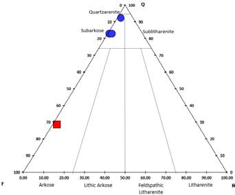


Upper Lyons Sandstone Member
Middle Lyons Sandstone Member
Lower Lyons Sandstone Member
Sandstone
Rock Canyon Open Space Park, Colorado Springs
Makowitz,
This poster, created by Astrid Makowitz from samples collected at Red Rock Canyon Open Space, described characteristics of the Upper, Middle, and Lower Lyons Sandstones and the Dakota Sandstone. Photomicrographs and accompanying plots provided a petrographic overview of the samples in terms of grain size, sorting, lithologic compositions, and cements. (Reproduced with permission from Astrid Makowitz).
Ph.D.,
Looking Glass Ltd.
Upper Lyons Sandstone Member


Middle Lyons Sandstone Member


Lower Lyons Sandstone Member


• Fine grained, very well sorted, well rounded grains of subarkose composition
• Predominantly iron oxide cemented (4%)
• Total macroporosity (primary intergranular and secondary) 24%
• Not as severely compacted as the Dakota due to iron oxide cement acting to stabilize the sandstone (IGV= 26%)

• Very coarse grained, poorly sorted, sub-rounded grains of arkose composition (predominantly feldspathic-rich rock fragments)
• Predominantly dolomite cemented (35%) with minor calcite cement (1%) (dolomite could be replacing calcite)
• Very little porosity (what you see is sampling/ thin section artifact)
• Carbonate cement was early reducing the effects of compaction (IGV=36%)

• Fine grained, moderately well sorted, well rounded grains of subarkose composition
• Predominantly dolomite (18.5%) and iron oxide (12.8%) cemented
• Total macroporosity (primary intergranular and secondary) is 11%
• Lower degree of compaction where dolomite cement is present and higher degree of grain packing without dolomite cement (IGV= 40%)
K= K-spar, D= Dolomite, I= Iron oxide
K= K-spar, D= Dolomite, C=Calcite
K= K-spar


Large, eolian cross beds in the Upper Lyons Sandstone. (Photo by Ron Parker)
The Dakota Sandstone capped by Benton Shale to the right. (Photo by Lew Kleinhans)
Sharon Milito was presented with a slab of petrified wood in appreciation of her role as the trip leader. (Photo by Laura Wray)

For much more detail about Red Rock Canyon Open Space geology, mining history, and the use of building stones from the quarries, please consult “Geologic Folio Red Rock Canyon Open Space, Colorado Springs, Colorado, Second Edition, 2019, by Ken Weissenburger, Sharon Milito, and Don Ellis.

RMAG Foundation Receives Generous Bequest
The RMAG Foundation recently received a very generous bequest from Robert Clyde Dickinson (Bob) who passed away on July 16, 2023, at the age of 95. This gift will enhance the Foundation’s philanthropic support of many organizations who share its mission statement: “To inspire and educate current and future geoscientists”. Scholarships for undergraduate and graduate earth science students are an important component of this mission.
The Foundation Trustees know only of Mr. Dickinson’s legacy through his obituary. Attempts have been made to identify someone in the geologic community who knew him, but as of now, no one has been identified. If you did happen to know him, you could send information to the Foundation’s email
address: rmagfoundation@gmail.com.
What is known is that Mr. Dickinson had an undergraduate geology degree from Syracuse University and attended graduate school at the University of Texas, studying petroleum geology. He worked at Skelly Oil Company and Texas Oil and Gas before moving to the Rocky Mountain region where he was a geologist at Odegard Resources. It appears that most of his career was spent as an independent petroleum geologist. An outdoor enthusiast and avid hiker, he spent a week at Thanksgiving most years in Bryce Canyon.
The RMAG Foundation is deeply honored by Mr. Dickinson’s generosity and is committed to the thoughtful spending of this bequest over time.
2024 Recipients of the K-12 Earth Science Teacher of the Year Award
The RMAG Foundation and RMAG are very pleased to announce TWO 2024 Earth Science Teacher of the Year Awardees! The two finalist are Kent Hups, Geology and Biology teacher at Northglenn High School, Adams 12 School District and Hannah Winters, science teacher at Performing Arts School on Broadway, Denver Public Schools. Each teachers will receive $2000 to further their professional development, and each school will receive $2000 to be use to support their earth science programs. These two teachers demonstrated excellence in their approach to teaching their students and their passion for earth science. Kent Hups is a long time teacher with over 20 years experience and Hannah is a mid-career teacher with 8 years of experience. Both teach in high school, where geology and
environment science courses are considered science electives in Colorado.
Kent Hups: Mr Hups teaches both geology and biology at Northglenn. His geology course is a year long course focusing on historical and physical geology. He uses geological and topographical map of Colorado as a foundation of learning and instills the importance of working with maps. Mr Hups utilizes inquiry-based, student directed learning to teach about the rock cycle, fossils, structural geology, tectonics and earthquakes. He incorporates real-world projects and classroom learning to give the students skills to research and find possible solutions to modern day issues such as climate change. His course assessments are not test based but abstract writing and group presentations, giving each student an


CONSIDER PUBLISHING IN THE

We invite you to contribute to the vibrant and dynamic Outcrop, where your geological discoveries can find a home among like-minded professionals. Whether you have a compelling geological story, ground breaking research, insightful book reviews, or something else looking for it’s geologic home, the Outcrop is the ideal space to share your expertise with the geological community. Our publication process ensures a swift transition from submission to publication, allowing your work to reach a global audience in a timely manner. Additionally, every published lead article is entered to win the Outcrop article of the year, and entered to win a free RMAG field trip.
Join us in fostering knowledge exchange and advancing the field of geology by considering The Outcrop as the premier outlet for your valuable contributions.
Contact the outcrop Editor Nate La Fontaine with your submission at nlafontaine@sm-energy.com


opportunity to highlight their individual strengths. He plans on using award funds to purchase Virtual Reality devices to enable students to “visit” different geological sites around Colorado and “see” the rocks that they previously have only come from a rock bin.
Sharee Blunt, Principal of Northglenn High School, shared “One of the most significant contributions Mr. Hups has made is his development of hands-on, inquiry-based learning experiences. By incorporating field trips to geological sites, interactive lab activities, and collaboration with local geologists through his work at the museum, Kent has made Geology tangible and exciting for students.
Another tidbit about Mr. Hups is he is a volunteer Research Associate with the Denver Museum of Nature and Science and spends part of his summers on dinosaur dig sites with the museum staff.
Hannah Winters: Ms. Winters teaches 9-12 grade sciences including earth science. Her course is a comprehensive class focused on an exploration of the dynamic geological process. She uses hands-on activities, field work and data analytical techniques to gain an understanding of earth processes and the human-earth interactions. Her goal as a teacher is to inspire, generate curiosity and foster a deeper understanding of geoscience process systems. She includes geology, the atmosphere, hydrosphere and biosphere in her teachings. Ms. Winters uses multiple instructional methods and inquiry-based techniques, acknowledging the different learning styles and diverse backgrounds of her students. She
believes students understand best through observation, experimentation and interactive learning that leads to increased critical thinking skills. She will use her award to provide more opportunities for students to do field work and develop resources to aid in implementation of performance assessment tools.
Hannah’s freshman class wrote her letter of recommendation. They expressed their were privileged to be her students and were impressed with her dedication and passion for teaching. Additionally, they stated “Ms Hannah has an exceptional ability to make complex scientific concepts accessible and engaging to students of all levels. She employs innovative teaching methods and incorporates a variety of instructional materials to cater to diverse learning styles, ensuring that every student has the opportunity to succeed”.
RMAG Foundation’s mission is to support geoscience educators and students at all levels. These two teachers embody the dedication, innovation and passion for geoscience that can ignite a curiosity for science among their students. Their innovative teaching methods are inspiring the next generation of geoscientists and we are pleased to honor them with this award. Both teachers will be recognized at the August 7th RMAG Luncheon meeting at the Denver Energy Resource Library and will be given a one-year membership to RMAG, funded by RMAG Foundation. Congratulation to both Kent Hups and Hannah Winters.


IN THE PIPELINE
AUGUST 7, 2024
RMAG Luncheon.
Speaker: David Godsey, Talk Title: “The Permian Basin: A Review of the Geologic History, Stratigraphy, Productive Trends, Hydrocarbon Generation and Current Industry Focus Plays.” In Person or Online. Denver Earth Resources Library, 730 17th Street, B1, Denver.
AUGUST 20, 2024
RMAG Golf Tournament. Arrowhead Golf Club, 10850 Sundown Trail, Littleton, CO.
AUGUST 31, 2024
RMAG On the Rocks Field Trip. Trip Leaders: Jon Stone and Dr. Lou Taylor. “Geology and Paleontology of the Canon City Area, CO.”
Tony Herrell from Lakewood, Colorado
Ruben Martinez from Littleton, Colorado
Edward Smith III with Smith Resources, LLC from Marshall, Texas
Anabelle Klien with GeoSyntec Consultants Inc. from Denver, Colorado
Tracy Jones Martin with ThinkOnward, LLC from Santa Fe, New Mexico
Cidney Christie with EY from Denver, Colorado
Lazaro Garza with Jacobs from Denver, Colorado
Claudio Ramos with Tracerco


Expanded geologic focus:
Why contribute?
• Reach
• Quarterly
• Permanent
• Quick
• Every
Why contribute?
Expanded geologic focus:
• Entire greater Rocky Mountain area of North America
• West Texas and New Mexico to northern British Columbia
• Entire greater Rocky Mountain area of North America
• Reach a broad industry and academic audience
• Great Plains and Mid-Continent region
• West Texas and New Mexico to northern British Columbia
• Quarterly peer reviewed journal
• Great Plains and Mid-Continent region Why contribute?
• Permanent archiving includes AAPG Datapages
• Reach a broad industry and academic audience
• Quarterly peer-reviewed journal
• Quick turn around time
• Every subdiscipline in the geosciences
• Quick turn-around time
https://www.rmag.org/publications/the
• Permanent archiving includes AAPG Datapages
https://www.rmag.org/publications/the
• Every subdiscipline in the geosciences
Expanded geologic focus:
area of North America
• Entire greater Rocky Mountain area of North America
northern British Columbia region
• West Texas and New Mexico to northern British Columbia
• Great Plains and Mid Continent region

Email: mgeditor@rmag.org
https://www.rmag.org/publications/the -mountain-geologist/

CALENDAR – AUGUST 2024
RMAG Luncheon.
RMAG On the Rocks Field Trip.