
RC drilling results delineate a continuous 1.4km strike of shallow gold mineralisation at Kokoseb
Highlights
Results received from eleven reverse circulation drill holes at Kokoseb extend shallow mineralisation along strike, including:
o KRC012: 11m at 1.87 g/t Au from 23m 42m at 1.57 g/t Au from 37m
o KRC009: 6m at 2.43 g/t Au from 23m
o KRC005: 36m at 1.18 g/t Au from 67m
o KRC004: 23m at 1.22 g/t Au from 27m
o KRC003 : 27m at 1.71 g/t Au from 72m
Reverse circulation drilling progressing well, with 24 holes for 4,902 metres completed at the end of September and further assay results expected in the coming weeks
Wia Gold Limited (ASX: WIA) (Wia or the Company) is pleased to report the final results from eleven reverse circulation (RC) drill holes KRC002 to KRC012 completed at the Kokoseb Gold Discovery (Kokoseb), situated on the Company’s Damaran Gold Project located in Namibia. Drill holes KRC002 to KRC011 were drilled along 1.4km strike of the northern side of Kokoseb, while drill hole KRC012 is located on the western flank of the anomaly Best results include 42m at 1.57 g/t Au, 11m at 1.87 g/t Au and 27m at 1.71 g/t Au
At the end of September, 24 RC holes for 4,902 metres have been completed at Kokoseb, the drill rig is currently progressing towards the south on the western flank of the anomaly.
Wia’s Chairman, Andrew Pardey, commented:

“These latest RC results demonstrate the potential to intersect in situ significant gold mineralisation under all of the 6km strike outline of the Kokoseb gold anomaly.
“RC drilling is quickly progressing the surface reconnaissance along strike, having already validated 1.4km strike length and currently extending the reconnaissance towards the south on the western flank of Kokoseb. Mineralisation intersected to date is open in all directions and at depth.
“We look forward to ramping up drilling activity at Kokoseb in 2023 with the addition of a second drill rig, which will focus on infilling and tracing down dip the actual results.”
RC drilling unlocks 1.4 km strike at Kokoseb
Eleven RC drill holes, KRC001 (previously reported) to KRC011, were drilled on the northern flank of the Kokoseb gold anomaly, which also includes Trench 5 and 6 results and diamond holes KDD007, KDD008, KDD010 and KDD012. The RC drill sections were spaced at 100m intervals on the western margin, around Trench 5 and then spaced at 200m intervals towards the east. At this stage, all sections along strike on the eastern side include single holes, the objective of which is to define the in situ mineralised zone before further systematic infill drilling commences
1 202 Hay Street, West Perth WA 6005
+61 8 9381
The main mineralised zone of the northern flank was intersected in all drill holes at widths varying from 25m to over 50m and at vertical depths varying from surface to approximately 70m. The intersections add up to a continuous zone of 1.4km strike, part of the potential total 6km outlined by the soil anomalism and by the diamond drill holes.

KRC012 is drilled on the top part of the western flank of Kokoseb, starting the reconnaissance of the mineralised trend that wraps around the granitic pluton, which includes drill holes KDD001 to KDD006.


Figure 1 Drilled and planned holes located on Kokoseb geology; significant intercepts on drillholes (in red, reported in this release and in black, previously reported); all intercepts >0.5 g/t Au1
1 Intercept calculated using 0.5 g/t cut off grade and 2m max consecutive internal low grade. See ASX announcements 7 June 2022, 27 July 2022 and 17 August 2022 for further information on previously reported results of diamond and RC drilling.

KRC002 is drilled on section with KRC001 and is the westernmost one drilled on the northern flank of Kokoseb (Figure 2). The mineralised zones on the drill section are split by a granitic intrusive, at this stage it is unclear whether the two sides correspond to different zones of mineralisation, as there are two distinct zones that were intersected in the next section 100m to the east (Figure 3) KRC002 includes a single intercept of 8m at 0.97 g/t Au from 123m.
The next section, which is located 100m east, includes drill holes KDD008, KDD012 and KRC003 (Figure 3). Two wide and high grade gold zones were intersected on the drill section, the upper zone and the lower zone. The upper zone correlates along strike towards the east and makes up the core zone of the northern flank of Kokoseb (the “main zone”). The lower zone has an unclear orientation and could be cutting through the upper zone (outside of the section). KRC003 includes the following intercepts:

27m at 1.71 g/t Au from 72m, including 14m at 2.13 g/t Au (upper zone)
7m at 1.32 g/t Au from 105m (upper zone)
7m at 0.98 g/t Au from 115m (upper zone)
6m at 1.59 g/t Au from 158m (lower zone)
10m at 1.57 g/t Au from 169m, including 5m at 2.56 g/t Au (lower zone)
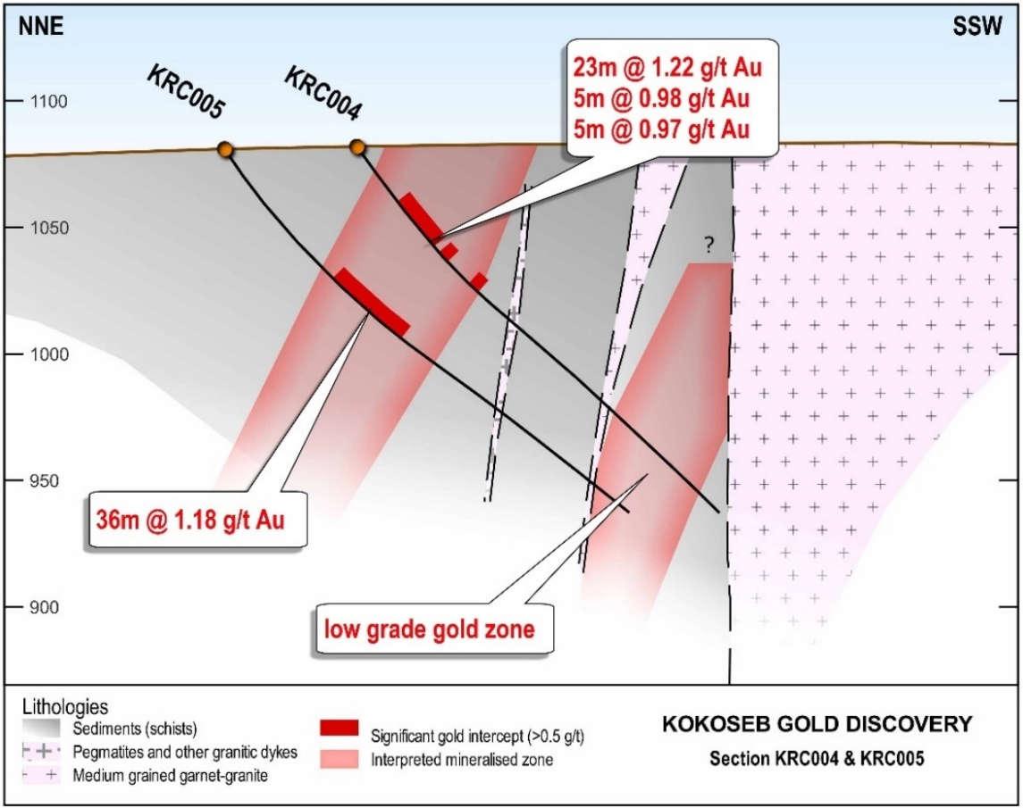
Drill section KRC004-KRC005 is drilled 100m east of the section that includes KRC003 (Figure 4). Both the drill holes have intersected significant mineralisation that is over 30m wide, correlating well with the upper zone from the previous drill section, including:
23m at 1.22 g/t Au from 27m, including 7m at 1.91 g/t Au (KRC004)
5m at 0.98 g/t Au from 53m (KRC004)
5m at 0.97 g/t Au from 70m (KRC004)
36m at 1.18 g/t Au from 67m, including 12m at 1.99 g/t Au (KRC005)
Figure 2 Drill section KRC001-KRC002 (intercepts in red, reported in this release)Figure 3 Drill section KRC003 (intercepts in red, reported in this release and in black, previously reported; trenches intercepts in italic)2

Figure 4 Drill section KRC004 KRC005 (intercepts in red, reported in this release)
2 See ASX announcements 7 June 2022 and 17 August 2022 for further information on previously reported results of diamond drilling.

KRC006 is drilled on section (Figure 5) located 100m east from the drill section KRC004 KRC005. The main mineralised zone has been intersected in the top part of the fresh horizon as a single intercept of 25m at 0.82 g/t. The drill hole includes the following intercepts:


25m at 0.82 g/t Au from 45m
3m at 0.58 g/t Au from 232m
3m at 1.12 g/t Au from 252m
KRC007 is drilled on section (Figure 6) located 200m east from drill hole KRC006 and 100m east of drill hole KDD007 The next drill holes, KRC008 to KRC011 are all drilled as single holes per section that are spaced at 200m intervals progressing towards the east from KRC007 (Figures 6 to 10). Drill holes KRC007 to KRC009 have intersected the main mineralised zone in the oxide horizon. Both the drill holes KRC010 and KRC011 have intersected the zone in the top part of the fresh horizon. Drill hole KRC011 has not returned any significant intercept that could be calculated, the zone only showing low grade gold results. All of these drill holes will have follow up infill down dip and along strike drilling closing the drilling spacing. Significant intercepts include:
23m at 0.78 g/t Au from 24m, including 7m at 1.28 g/t Au (KRC007)
6m at 0.88 g/t Au from 52m (KRC007)
3m at 1.11 g/t Au from 68m (KRC007)
3m at 0.54 g/t Au from 1m (KRC008)
8m at 1.30 g/t Au from 15m (KRC008)
11m at 0.90 g/t Au from 28m (KRC008)
6m at 0.96 g/t Au from 14m (KRC009)
6m at 2.43 g/t Au from 23m (KRC009)
13m at 1.07 g/t Au from 56m (KRC010)
Figure 5 Drill section KRC006 (intercepts in red, reported in this release)Figure 6 Drill section KRC007 (intercepts in red, reported in this release)
Figure 7 Drill section KRC008 (intercepts in red, reported in this release)


Figure 8 Drill section KRC009 (intercepts in red, reported in this release)

Figure 9 Drill section KRC010 (intercepts in red, reported in this release)


Figure 10 Drill section KRC011 (intercepts in red, reported in this release)


Figure 11 Drill section KRC012 (intercepts in red, reported in this release)
KRC012 is located on the western flank of the Kokoseb gold anomaly (Figure 12), 300m north from drill section KDD005 KDD006 that returned unconstrained intercepts of 43.0m at 1.14 g/t Au (KDD005, from surface) and 34.4 at 1.56 g/t Au (KDD006) The main mineralised zone in KRC012 was intersected as an unconstrained intercept of 58m at 1.52 g/t Au, which includes 11m at 1.87 g/t Au and 42m at 1.57 g/t Au Geology on this part of the anomaly is positively complex and includes a swarm of granitic and pegmatitic intrusions within the sediment package. The drillhole includes the following intercepts:
4m at 0.81 g/t Au from surface
3m at 0.74 g/t Au from 7m 11m at 1.87 g/t Au from 23m 42m at 1.57 g/t Au from 37m
RC drilling program progress
At the end of September, 24 RC holes for 4,902 metres have been completed at Kokoseb, with assay results pending for 12 holes. The RC drill rig is progressing towards the south, drilling one to two holes per section, depending on the understanding of the geological context.
A second drill rig will be mobilised from January 2023, which will focus on infill drilling on the current sections, while the other rig continues to focus on along strike reconnaissance drilling
This announcement has been authorised for release by the board of directors of Wia Gold Limited.
Contact details
Pardey
Competent Person’s Statement
The information in this announcement that relates to exploration results at the Kokoseb Gold Anomaly located on the Company’s Damaran Gold Project is based on information compiled by Company geologists and reviewed by Mr Pierrick Couderc, in his capacity as Exploration Manager of WiaGold Limited. Mr. Couderc is a member of both the Australian Institute of Mining and Metallurgy and the Australian Institute of Geoscientists and has sufficient experience which is relevant to the style of mineralisation and type of deposit under consideration and to the activity which he is undertaking to qualify as a Competent Person as defined in the 2012 edition of the Australasian Code for Reporting of Exploration Results, Mineral Resources and Ore Reserves. Mr. Couderc consents to the inclusion in the report of the matters based upon the information in the form and context in which it appears.
Reference to previous ASX Announcements
In relation to previously reported exploration results included in this announcement, the dates of which are referenced, the Company confirms that it is not aware of any new information or data that materially affects the information included in those announcements.
About Wia’s Namibia Projects
Since 2018 the Company has successfully consolidated a very large land position on the Damaran belt in central Namibia (the Damaran Project), which is strategically located along key regional structures. The Damaran Project consists of 12 tenements with a total area of over 2,700km2 held under joint venture with the state owned mining company, Epangelo and a local Namibian group.
The location of the Company’s Namibian Projects is shown in Figure 12
Appendix 1. Kokoseb Location of RC drillholes

Hole
KRC002
KRC003
KRC004
KRC005
KRC006
KRC007
KRC008
KRC009
KRC010
KRC011
1087 264 -55 200
1080 209 -55 200
1082 204 -55 200
1081 216 -55 200
1083 283 -55 200
1081 126 -55 200
1079 138 -55 200
1082 210 -55 200
1078 132 -55 200
1079 255 -55
144 -54.5
Appendix 2. RC drill holes gold assays, using a cut off grade of 0.2 g/t gold and max 2m consecutive internal waste material
Hole ID From (m) To (m) Gold g/t
KRC002 99 100 0.307
KRC002 100 101 0.712
KRC002 101 102 0.286
KRC002 102 103 0.428
KRC002 103 104 0.012
KRC002 104 105 0.114
KRC002 105 106 0.2
KRC002 106 107 0.027
KRC002 107 108 0.295
KRC002 108 109 0.046
KRC002 109 110 0.97
KRC002 110 111 0.173
KRC002 111 112 0.435
KRC002 112 113 0.23
KRC002 113 114 0.189
KRC002 114 115 0.911
KRC002 115 116 0.271
KRC002 116 117 0.478
KRC002 122 123 0.365
KRC002 123 124 0.658
KRC002 124 125 1.735
KRC002 125 126 0.562
KRC002 126 127 0.196
KRC002 127 128 0.304
KRC002 128 129 2.41
KRC002 129 130 0.11
KRC002 130 131 1.76
KRC003 52 53 0.244
KRC003 53 54 0.293
KRC003 54 55 0.201
KRC003 55 56 0.365
KRC003 56 57 0.186
KRC003 57 58 1.17
KRC003 58 59 0.284
KRC003 59 60 0.08
KRC003 60 61 0.058
KRC003 61 62 0.392
KRC003 62 63 0.524
KRC003
KRC003
KRC003
KRC003
KRC003
KRC003
KRC003
KRC003
KRC003
KRC003
KRC003
KRC003
KRC003
KRC003
KRC003
KRC003
KRC003
KRC003
KRC003
KRC003
KRC003
KRC003
KRC003
KRC003
KRC003
KRC003
KRC003
KRC003
KRC003
KRC003
KRC003
KRC003
KRC003
KRC003
KRC003
KRC003
KRC003
KRC003
KRC003
Hole ID From (m) To (m) Gold g/t
KRC003 117 118 1.595
KRC003 118 119 0.59
KRC003 119 120 0.674
KRC003 120 121 0.199
KRC003 121 122 0.533
KRC003 122 123 0.025
KRC003 123 124 0.362
KRC003 124 125 0.416
KRC003 125 126 0.443
KRC003 126 127 0.317 KRC003 127 128 0.025
KRC003 128 129 0.618 KRC003 129 130 0.473 KRC003 130 131 0.38 KRC003 131 132 0.278 KRC003 132 133 0.179
64 0.231
5.97
1.385
0.412
0.579
1.155
1.735
0.501
0.559
1.065
2.66
0.717
3.45
0.208
1.12
3.7
1.075
0.732
0.936
1.35
5.3
5.08
2.4
0.34
1.56
0.611
0.668
0.79
0.217
0.406
0.454
0.517
0.258
0.167
1.515
2.69
2.85
1.265
2.1
1.175
KRC003 133 134 0.212 KRC003 134 135 0.279 KRC003 135 136 0.399 KRC003 136 137 0.246 KRC003 137 138 0.516 KRC003 157 158 0.293 KRC003 158 159 3.67 KRC003 159 160 0.995 KRC003 160 161 3.46 KRC003 161 162 0.156 KRC003 162 163 0.65 KRC003 163 164 0.617 KRC003 164 165 0.312 KRC003 165 166 0.45 KRC003 166 167 0.289 KRC003 167 168 0.386 KRC003 168 169 0.207 KRC003 169 170 2.99 KRC003 170 171 2.66 KRC003 171 172 2.15 KRC003 172 173 2.92 KRC003 173 174 2.19 KRC003 174 175 0.79 KRC003 175 176 0.667 KRC003 176 177 0.16 KRC003 177 178 0.562 KRC003 178 179 0.629 KRC003 179 180 0.401 KRC003 180 181 0.098 KRC003 181 182 0.213 KRC003 182 183 0.009 KRC003 183 184 0.247 KRC003 184 185 0.543 KRC003 185 186 0.127 KRC003 186 187 0.387 KRC003 187 188 0.926 KRC003 188 189 0.39 KRC003 189 190 0.43 KRC003 190 191 0.067 KRC003 191 192 0.376 KRC003 192 193 0.327 KRC004 15 16 0.206 KRC004
0.251 KRC004
0.15 KRC004
0.174 KRC004
0.335 KRC004
0.134 KRC004
0.237 KRC004
1.075 KRC004
0.366 KRC004
0.267 KRC004
0.352 KRC004
0.374 KRC004
0.651 KRC004
0.783 KRC004
1.195 KRC004
0.523 KRC004
1.13 KRC004
0.552 KRC004
2.63 KRC004
1.225 KRC004
4.43
Hole ID From (m) To (m) Gold g/t
KRC004
KRC004
KRC004
KRC004
KRC004
KRC004
KRC004
KRC004
KRC004
KRC004
KRC004
KRC004
KRC004
KRC004
KRC004
KRC004
KRC004
KRC004
KRC004
KRC004
KRC004
KRC004
KRC004
KRC004
KRC004
KRC004
KRC004
KRC004
KRC004
KRC004
KRC004
KRC004
1.49
1.095
0.739
1.785
0.667
1.555
0.2
1.345
1.49
0.557
1.105
0.614
1.545
0.771
0.404
0.473
0.498
1.19
2.16
0.429
0.347
0.77
0.471
0.39
0.209
0.242
0.251
0.577
2.21
0.502
0.995
0.59
KRC004 147 148 0.48
KRC004 148 149 0.348
KRC004 149 150 0.073
KRC004 150 151 0.051
KRC004 151 152 0.309
KRC005 61 62 0.216
KRC005
KRC005
KRC005
KRC005
KRC005
KRC005
KRC005
KRC005
KRC005
KRC005
KRC005
KRC005
KRC005
KRC005
KRC005
KRC005
KRC005
KRC005
KRC005
KRC005
KRC005
KRC005
KRC005
KRC005
KRC005
KRC005
KRC005
KRC005
KRC005
KRC005
KRC005
KRC005
KRC005
Hole ID From (m) To (m) Gold g/t
KRC006
KRC006
KRC006
KRC006
63 0.154
64 0.119
65 0.461
0.44
0.292
0.971
0.241
1.19
0.355
0.52
0.973
1.54
1.07
1.375
0.906
1.88
1.03
1.795
1.45
1.455
1.945
1.62
7.86
0.687
0.244
0.531
0.77
1.365
0.569
2.5
1.875
0.65
0.216
1.25
0.282
0.379
0.834
0.604
0.449
0.479
0.779
0.296
0.676
0.399
0.229
0.192
0.19
KRC006
0.064
0.225 KRC006
KRC006
0.259 KRC006
0.527 KRC006
0.858 KRC006
48 1.14 KRC006
49 0.719 KRC006
0.101 KRC006
0.179 KRC006
52 0.619 KRC006
2.18 KRC006 53 54 0.335 KRC006 54 55 1.055 KRC006 55 56 0.713 KRC006 56 57 0.391 KRC006 57 58 0.168 KRC006 58 59 0.756 KRC006 59 60 0.565 KRC006 60 61 1.505 KRC006 61 62 0.523 KRC006 62 63 4.05 KRC006 63 64 0.577 KRC006 64 65 0.511 KRC006 65 66 0.657 KRC006 66 67 0.541 KRC006 67 68 0.342 KRC006 68 69 0.409 KRC006 69 70 1.04 KRC006 70 71 0.118 KRC006 71 72 0.359 KRC006 72 73 0.366 KRC006 73 74 0.259 KRC006 74 75 0.065 KRC006 75 76 0.389 KRC006 76 77 0.17 KRC006 77 78 0.557 KRC006 78 79 0.128 KRC006 79 80 0.28 KRC006 224 225 0.652 KRC006 225 226 0.899 KRC006 226 227 0.121 KRC006 227 228 0.238 KRC006 232 233 0.638 KRC006 233 234 0.156 KRC006 234 235 0.949 KRC006 235 236 0.387 KRC006 236 237 0.256 KRC006 237 238 0.226 KRC006 238 239 0.21 KRC006 239 240 0.24 KRC006 240 241 0.009 KRC006 241 242 1.58 KRC006 242 243 0.8 KRC006 243 244 0.312 KRC006 244 245 0.241 KRC006 245 246 0.157 KRC006 246 247 0.241 KRC006 247 248 0.478 KRC006 251 252 0.45 KRC006 252 253 0.785 KRC006 253 254 1.345 KRC006 254 255 1.235 KRC006
256 0.185 KRC006
257 0.036 KRC006
258 0.256 KRC006
259 0.236 KRC006
260 0.354 KRC006
261 0.444 KRC007
25 0.571 KRC007
26 1.66 KRC007
27 0.561 KRC007
28 0.301 KRC007
29 0.243 KRC007
30 0.596 KRC007 30 31 0.122
Hole ID From (m) To (m) Gold g/t
KRC007
KRC007
KRC007
KRC007
KRC007
KRC007
KRC007
KRC007
KRC007
KRC007
KRC007
KRC007
KRC007
KRC007
KRC007
KRC007
KRC007
KRC007
KRC007
KRC007
KRC007
KRC007
KRC007
KRC007
KRC007
KRC007
KRC007
KRC007
KRC007
KRC007
KRC007
KRC007
KRC007
KRC007
KRC007
KRC007
KRC007
KRC007
KRC007
KRC007
KRC007
KRC008
KRC008
KRC008
KRC008
KRC008
KRC008
KRC008
KRC008
KRC008
KRC008
KRC008
KRC008
KRC008
KRC008
KRC008
KRC008
KRC008
KRC008
KRC008
KRC008
KRC008
KRC008
KRC008
KRC008
KRC008
KRC008
KRC008
KRC008
KRC008
KRC008
KRC008
KRC008
KRC008
KRC008
KRC008
KRC009
KRC009
KRC009
KRC009
0.203
0.603
0.273
0.308
0.719
0.939
2.79
1.895
0.374
0.194
0.59
2.04
1.105
0.309
0.875
0.606
0.117
0.265
0.274
0.318
0.174
1.425
0.187
0.393
0.591
2.15
0.562
0.396
0.17
0.226
0.357
0.462
64 0.111
1.115
0.295
0.009
0.144
0.75
1.48
1.085
0.2
0.275
0.582
0.439
0.6
0.325
0.272
0.279
0.225
1.665
0.972
1.835
2.18
0.567
0.283
0.249
2.66
0.13
0.48
0.207
0.212
0.396
2.2
1.16
0.726
2.19
0.364
34 0.295
1.405
0.068
0.57
0.25
0.648
0.379
41 0.292
42 0.279
10 0.912
0.174
0.393
13 0.384
Hole ID From (m) To (m) Gold g/t
KRC009 13 14 0.466
KRC009
KRC009
15 0.735
16 0.14
KRC009 16 17 0.274
KRC009 17 18 2.73
KRC009 18 19 1.05
KRC009 19 20 0.824
KRC009 20 21 0.151
KRC009 21 22 0.219 KRC009 22 23 0.113 KRC009 23 24 5.1
KRC009 24 25 0.834
KRC009 25 26 2.18 KRC009 26 27 4.39 KRC009 27 28 1.58 KRC009 28 29 0.524 KRC009 29 30 0.395 KRC009 30 31 0.205 KRC009 31 32 0.128 KRC009 32 33 0.214 KRC009 33 34 0.169 KRC009 34 35 0.497 KRC009 35 36 0.242 KRC009 36 37 2.01 KRC010 48 49 0.449 KRC010 49 50 1.52 KRC010 50 51 0.261 KRC010 56 57 0.551 KRC010 57 58 2.74 KRC010 58 59 0.262 KRC010 59 60 1.31 KRC010 60 61 0.457 KRC010 61 62 0.161 KRC010 62 63 2.35 KRC010 63 64 2.8 KRC010 64 65 1.285 KRC010 65 66 0.212 KRC010 66 67 0.165 KRC010 67 68 0.706 KRC010 68 69 0.869 KRC010 69 70 0.059 KRC010 70 71 0.219 KRC010 71 72 0.363 KRC011 51 52 0.59 KRC011 52 53 0.555 KRC011 53 54 0.499 KRC012 0 1 0.826 KRC012
2 0.464 KRC012 2 3 1.105 KRC012 3 4 0.835 KRC012
0.324 KRC012
0.444 KRC012
0.464 KRC012
1.015 KRC012
0.141 KRC012
1.06 KRC012
24 1.99 KRC012
0.142 KRC012
0.972 KRC012
0.621 KRC012
0.128 KRC012
1.175 KRC012
1.625 KRC012
1.15 KRC012
2.9 KRC012
9.28 KRC012
0.594 KRC012
0.236 KRC012
0.316 KRC012
0.145 KRC012
0.707 KRC012
2.63 KRC012
0.62 KRC012
0.945 KRC012
2.06 KRC012
1.52 KRC012
1.75 KRC012
3.79 KRC012
2.95 KRC012
1.635
Hole ID From (m) To (m) Gold g/t
KRC012
KRC012
KRC012
KRC012
KRC012
KRC012
KRC012
KRC012
KRC012
KRC012
KRC012
0.765
0.035
50 0.075
51 0.869
52 1.325
53 0.623
0.711
0.265
56 0.717
57 5.07
58 2.99
KRC012 58 59 15.25
KRC012 59 60 1.89
KRC012 60 61 0.277
KRC012 61 62 0.209
KRC012 62 63 0.609
KRC012
64 0.547
KRC012 64 65 0.299
KRC012 65 66 1.505
Hole ID From (m) To (m) Gold g/t
KRC012 66 67 0.777
KRC012 67 68 0.521
KRC012 68 69 1.04
KRC012 69 70 0.989
KRC012 70 71 0.231
KRC012 71 72 0.746
KRC012 72 73 0.765
KRC012 73 74 0.351
KRC012 74 75 0.743 KRC012 75 76 1.38 KRC012 76 77 3.91
KRC012 77 78 1.295 KRC012 78 79 0.635 KRC012 79 80 0.389 KRC012 80 81 0.305
KRC012 105 106 0.433 KRC012 106 107 0.681 KRC012 107 108 0.39
Appendix 3. JORC Table 1 Reporting
Section 1 Sampling Techniques and Data Criteria JORC Code explanation
Sampling techniques
Nature and quality of sampling (eg cut channels, random chips, or specific specialised industry standard measurement tools appropriate to the minerals under investigation, such as down hole gamma sondes, or handheld XRF instruments, etc). These examples should not be taken as limiting the broad meaning of sampling.
Include reference to measures taken to ensure sample representivity and the appropriate calibration of any measurement tools or systems used.
Aspects of the determination of mineralisation that are Material to the Public Report.
In cases where ‘industry standard’ work has been done this would be relatively simple (eg ‘reverse circulation drilling was used to obtain 1 m samples from which 3 kg was pulverised to produce a 30 g charge for fire assay’). In other cases, more explanation may be required, such as where there is coarse gold that has inherent sampling problems. Unusual commodities or mineralisation types (eg submarine nodules) may warrant disclosure of detailed information.
Commentary
Reverse circulation (RC) drilling was completed using a dedicated RC rig. Drillholes were angled 55° from surface.
RC sampling was undertaken along the entire length of the drill holes. Samples were collected from the rig cyclone, split through a riffle splitter and then bagged in a plastic sample bag; samples are typically 1m length and a circa 2 4kg weight. A duplicate sample was retained on site for future reference.
Drilling techniques
Drill type (eg core, reverse circulation, open hole hammer, rotary air blast, auger, Bangka, sonic, etc) and details (eg core diameter, triple or standard tube, depth of diamond tails, face sampling bit or other type, whether core is oriented and if so, by what method, etc).
RC drilling was carried out using a 140mm face sampling hammer
Drill sample recovery
Method of recording and assessing core and chip sample recoveries and results assessed.
Measures taken to maximise sample recovery and ensure representative nature of the samples.
Whether a relationship exists between sample recovery and grade and whether sample bias may have occurred due to preferential loss/gain of fine/coarse material.
Logging
Whether core and chip samples have been geologically and geotechnically logged to a level of detail to support appropriate Mineral Resource estimation, mining studies and metallurgical studies.
Whether logging is qualitative or
RC recoveries were determined by weighting each drill metre bag. Samples are sieved and logged by supervising Geologist; sample weight, quality, moisture and any contamination are recorded.
RC samples quality and recovery was excellent, with dry samples and consistent weight obtained
All drill holes were logged in the field by Company Geologists.
On the RC holes, lithologies, alteration, minerals were recorded. Samples chips are collected and sorted into chip trays for future geological references.
Drill holes were logged in full. Logging was
Criteria JORC Code explanation Commentary
quantitative in nature. Core (or costean, channel, etc) photography.
The total length and percentage of the relevant intersections logged.
Sub sampling techniques and sample preparation
If core, whether cut or sawn and whether quarter, half or all core taken.
If non core, whether riffled, tube sampled, rotary split, etc and whether sampled wet or dry.
For all sample types, the nature, quality and appropriateness of the sample preparation technique.
Quality control procedures adopted for all sub sampling stages to maximise representivity of samples.
Measures taken to ensure that the sampling is representative of the in situ material collected, including for instance results for field duplicate/second half sampling.
Whether sample sizes are appropriate to the grain size of the material being sampled.
qualitative and quantitative in nature.
Quality of assay data and laboratory tests
The nature, quality and appropriateness of the assaying and laboratory procedures used and whether the technique is considered partial or total.
For geophysical tools, spectrometers, handheld XRF instruments, etc, the parameters used in determining the analysis including instrument make and model, reading times, calibrations factors applied and their derivation, etc.
Nature of quality control procedures adopted (eg standards, blanks, duplicates, external laboratory checks) and whether acceptable levels of accuracy (ie lack of bias) and precision have been established.
The RC samples were collected from the rig cyclone and passed through a riffle splitter to reduce sample weight to a circa 2 4kg.
The sampling technique is considered industry standard and effective for this style of drilling.
Samples were crushed and pulverized at the ALS laboratory in Okahandja before being shipped to Johannesburg for assay.
RC samples were assayed using method Au AA24 for gold.
The sample preparation procedures carried out are considered acceptable. Blanks, standards (CRM) and duplicates are used to monitor Quality Control and representativeness of samples.
Verification of sampling and assaying
The verification of significant intersections by either independent or alternative company personnel.
The use of twinned holes.
Documentation of primary data, data entry procedures, data verification, data storage (physical and electronic) protocols.
Discuss any adjustment to assay data.
RC samples were assayed by 50g Lead collection fire assay in new pots and analysed by Atomic Absorption Spectroscopy (AAS) for gold.
Industry best practice procedures were followed and included submitting blanks, field duplicates and Certified Reference Material. Acceptable levels of accuracy and precision have been confirmed.
Location of data points
Accuracy and quality of surveys used to locate drill holes (collar and down hole surveys), trenches, mine workings and other locations used in Mineral Resource estimation.
Specification of the grid system used.
Quality and adequacy of topographic control.
At this stage, the intersections have been verified by the Company Geologists.
All field data is manually collected, entered into excel spreadsheets, validated and loaded into a database.
Electronic data is stored on a cloud server and routinely backed up.
Data is exported from the database for processing in a number of software packages.
Drill holes collar locations were recorded at the completion of each hole by hand held GPS.
Coordinates collected are in the WGS84 Zone 33S grid system
Criteria JORC Code explanation Commentary
Data spacing and distribution
Data spacing for reporting of Exploration Results.
Whether the data spacing and distribution is sufficient to establish the degree of geological and grade continuity appropriate for the Mineral Resource and Ore Reserve estimation procedure(s) and classifications applied.
Whether sample compositing has been applied.
RC drill holes reported here were planned on a set grid with spacing varying between 100m and 200m, depending on the sections. They should be considered as early stage exploration holes and will require further infill.
Orientation of data in relation to geological structure
Whether the orientation of sampling achieves unbiased sampling of possible structures and the extent to which this is known, considering the deposit type.
If the relationship between the drilling orientation and the orientation of key mineralised structures is considered to have introduced a sampling bias, this should be assessed and reported if material.
Sample security
Audits or reviews
The measures taken to ensure sample security.
The results of any audits or reviews of sampling techniques and data.
Drill holes were positioned using geological information collected from the trenches and from the detailed mapping completed over the prospect. They are positioned perpendicular to the main schistosity and so to the inferred mineralisation main controls.
Sampling is supervised by a Company Geologist and all samples are delivered to the laboratory in Okahandja by company staff.
No reviews or audits have been conducted.
Section 2 Reporting of Exploration Results (Criteria listed in the preceding section also apply to this section.)
Criteria JORC Code explanation Commentary
Mineral tenement and land tenure status
Type, reference name/number, location and ownership including agreements or material issues with third parties such as joint ventures, partnerships, overriding royalties, native title interests, historical sites, wilderness or national park and environmental settings.
The security of the tenure held at the time of reporting along with any known impediments to obtaining a licence to operate in the area.
The Damaran Project comprises 12 exclusive prospecting licenses (EPLs 6226, 4833, 8039, 7246, 4818, 4953, 6534, 6535, 6536, 8249,7327,7980) and located in central Namibia.
EPL6226 is 100% held by WiaGold in the name of Aloe Investments One Hundred and Ninety Two (Pty) Ltd.
EPL4833, 4818, 7246, 8039 and 8249 are held under an 80% earn in and join venture agreement with Epangelo Mining Limited, a private mining investment company with the Government of the Republic of Namibia as the sole shareholder.
EPL6534, 6535, 6536, and 4953 are held under a company called Gazina Investments which is owned 90% by Wia and 10% by the vendor
EPL7980 is 100% held by WiaGold in the name of Damaran Exploration Namibia (PTY) Ltd.
EPL7327 is under an agreement with an exclusive option to acquire the permit under a NewCo at Wia election.
All granted tenements are in good standing and there are no material issues affecting the
Criteria JORC Code explanation Commentary tenements.
Exploration done by other parties
Geology
Acknowledgment and appraisal of exploration by other parties.
Work completed prior to WiaGold includes stream sediment sampling, mapping, soil and rock chip sampling by Teck Cominco Namibia but data is unavailable.
This work did not cover the Okombahe permit, host of the Kokoseb gold discovery.
Deposit type, geological setting and style of mineralisation.
Kokoseb mineralisation is hosted by sediments (biotite schists) which have been intruded by several granitic phases. The gold anomaly appears as a contact like aureole of the central granitic pluton, with a diameter of approximately 3km in each direction
Drill hole Information
A summary of all information material to the understanding of the exploration results including a tabulation of the following information for all Material drill holes:
o easting and northing of the drill hole collar
o elevation or RL (Reduced Level elevation above sea level in metres) of the drill hole collar
o dip and azimuth of the hole
o down hole length and interception depth
o hole length.
If the exclusion of this information is justified on the basis that the information is not Material and this exclusion does not detract from the understanding of the report, the Competent Person should clearly explain why this is the case.
see tables in the appendix Data aggregation methods
In reporting Exploration Results, weighting averaging techniques, maximum and/or minimum grade truncations (eg cutting of high grades) and cut off grades are usually Material and should be stated.
Where aggregate intercepts incorporate short lengths of high grade results and longer lengths of low grade results, the procedure used for such aggregation should be stated and some typical examples of such aggregations should be shown in detail.
The assumptions used for any reporting of metal equivalent values should be clearly stated.
Reported intercepts are calculated using weighted average at a cut off grade of 0.5 g/t Au and allowing internal dilution of maximum 2m consecutive low grade material
Relationshi p between mineralisati on widths and
These relationships are particularly important in the reporting of Exploration Results.
If the geometry of the mineralisation with respect to the drill hole angle is known, its nature should be reported.
If it is not known and only the down hole
Results reported in this announcement are considered to be of an early stage in the exploration of the project.
Mineralisation geometry is not accurately known so intercepts are reported as they appear from the sampling.
Criteria JORC Code explanation Commentary
intercept lengths
Diagrams
lengths are reported, there should be a clear statement to this effect (eg ‘down hole length, true width not known’).
Appropriate maps and sections (with scales) and tabulations of intercepts should be included for any significant discovery being reported These should include, but not be limited to a plan view of drill hole collar locations and appropriate sectional views.
Plan view maps of all drillhole are included.
Balanced reporting
Where comprehensive reporting of all Exploration Results is not practicable, representative reporting of both low and high grades and/or widths should be practiced to avoid misleading reporting of Exploration Results.
All samples with assays have been reported.
Other substantive exploration data
Other exploration data, if meaningful and material, should be reported including (but not limited to): geological observations; geophysical survey results; geochemical survey results; bulk samples size and method of treatment; metallurgical test results; bulk density, groundwater, geotechnical and rock characteristics; potential deleterious or contaminating substances.
No other exploration data is being reported at this time.
Further work
The nature and scale of planned further work (eg tests for lateral extensions or depth extensions or large-scale step-out drilling).
Diagrams clearly highlighting the areas of possible extensions, including the main geological interpretations and future drilling areas, provided this information is not commercially sensitive.
Refer to the text in the announcement for information on follow up and/or next work programs.