
ASX ANNOUNCEMENT ASX Codes: PUA, PUAOD 26 October 2022
For personal use only
Platinum-Palladium Horizons Intersected at Rixon Confirming Copper-Nickel-PGE Fertility
Highlights
• At Lady Alma, visible, weak, disseminated mineralisation was logged in GRRC005 over 150m (chalcopyrite within anomalous nickel sulphur horizons). Key copper intersections: o from 34m, 3m at 0.61% Cu, including 1m @ 1.14% Cu; and o from 214m, 1m at 1.06% Cu
• Elevated Platinum and Palladium were intersected for the first time within the project area at Rixon, indicating a Copper Nickel PGE system. Key intersections: o GRRC004 intersected 1m at 0.82g/t 3E (Pt+Pd+Au), 0.54% Cu and 0.10% Co; and o GRRC006 intersected 15m at 0.29 g/t 3E (Pt+Pd+Au), including 4m at 0.52g/t 3E from 345m to end of hole

• At Target B, multiple zones of disseminated sulphides were logged and associated with elevated sulphur, from 364m GRRC002 intersected 8m at 0.7g/t Au, including 4m at 1.1g/t Au
• The RC program confirmed multiple zones of anomalous sulphides at Lady Alma and Target B and identified Pt and Pd at Rixon
• Peak is a successful applicant in the Exploration Incentive Scheme and has been awarded a $180,000 grant to test EM anomalies identified at Copper Hills and its relationship to Rixon
Peak Minerals Limited Registered Office: Level 1, Suite 23, 513 Hay St, Subiaco WA 6008 Email: admin@peakminerals.com.au ACN: 072 692 365 www.peakminerals.com.au
 Figure 1. 4m of visible chalcopyrite from 34m to 39m in GRRC005
For personal use only
CEO, Jennifer Neild, stated, “The elevated platinum and palladium results in two of the holes have not been seen before anywhere in the Lady Alma Igneous Complex, which we consider very exciting. We have now confirmed Cu Ni PGE fertility with the potential for more. We have come a long way in mapping this system out and follow up drilling is considered absolutely necessary. With the recent success of the Copper Hills EM reprocessing identifying a couple of new anomalies to be tested, it has now become evident that diamond drilling Rixon and Copper Hills together is necessary. With the award of the EIS co funding amount of $180,000, we will be preparing to diamond drill these anomalies as soon as possible.”
During June 2022, Peak Minerals Limited (ASX: PUA) (Peak or the Company) undertook a reverse circulation (RC) drilling program at the Lady Alma, Rixon and Target B prospects on the Company’s 100% owned Green Rocks Project, Western Australia. The program was designed to follow up on geophysical anomalies and test favourable geology.
At Rixon, GRRC004 tested a weakly conductive modelled EM plate. The hole intersected 1m of elevated Pt, Pd and Au totalling 0.82g/t 3E1 with 0.54% Cu and 0.10% Co. This is the first occurrence of Pt Pd Co in the Lady Alma Igneous Complex (LAIC).
GRRC006, which was drilled west from Rixon towards Lady Alma and ended in 15m at 0.29 g/t 3E, including 4m at 0.52g/t 3E, will be extended with a diamond tail. This second intersection of Pt-PdAu further highlights the Cu Ni PGE potential of the LAIC.
At Lady Alma, a moderate conductor was tested to the north west of the 2021 diamond drilling program (which includes high grade intersections of 0.13m at 4.95% Cu and 0.70% Ni and 0.20m at 4.18% Cu and 0.16% Ni2). Disseminated copper mineralisation was seen throughout the hole with intersections from 35m of 3m at 0.68% Cu, including 1m at 1.14% Cu, and from 214m of 1m at 1.06% Cu. Anomalous copper values over 150m confirmed the logging of disseminated mineralisation, which could be mapping the top of more massive mineralisation. GRRC002 intersected 8m at 0.75g/t Au, including 4m at 1.09g/t Au. This intersection occurred within a gabbroic intrusion and was associated with unusually high sulphur.
The Company is also pleased to announce that is a successful applicant in the Western Australian Government’s Exploration Incentive Scheme (EIS) and has been awarded a $180,000 grant which will be used to:
o follow up the link between Rixon and Copper Hills;
o test magmatic sulphides seen in historic Copper Hills core; and
o test deeper anomalies picked up in VTEM and Heli EM surveys.
2
1 3E = Palladium (Pd) + Platinum (Pt) + Gold (Au), with an average in situ ratio of ~2:5:3 (Pd:Pt:Au) 2 Refer ASX release dated 18 March 2022 ‘Nickel Sulphide Mineralisation Confirmed at Green Rocks’.
For personal use only
Between October 2021 and June 2022, a staged exploration program commenced at the Green Rocks Project, 35km south east of Meekatharra, to investigate the prospectivity of the LAIC. With positive chemistry and geophysical results, the Company continued with a detailed Moving Loop Electromagnetic (MLEM) survey in May 2022. The survey was completed over the Target B, Rixon and Lady Alma prospects based on anomalies identified from Heli EM and VTEM data.

At Rixon and Target B, the MLEM identified several weakly conductive bodies and, at Lady Alma, a moderately conductive (~1200 Siemen) plate was modelled. It is not unusual for a magmatic sulphide target to have a limited or low EM response because of depth to more massive targets, but weak conductors may indicate alteration or disseminated mineralisation proximal to or associated with massive mineralisation. When the geology and chemistry is right, weak and moderately conductive anomalies should be followed up.
3
Figure 2. Overview map of Target B, Lady Alma, Rixon and references to Copper Hills prospects.
For personal use only
In June 2022, the RC drill program was completed with the holes designed to test shallow targets identified from the EM surveys completed. The RC drilling is the precursor to a planned diamond drilling program as part of the staged exploration strategy at our Green Rocks Project.
Three of the holes were surveyed using Downhole Electromagnetics (DHEM) to further resolve conductors and help guide planned diamond drilling (one hole at Target B, one hole at Lady Alma and one hole at Rixon). The surveyed holes didn’t show clear off hole conductors. The holes also targeted prospective geology and geochemical anomalies delineated from mapping, air core drilling and EM surveys. Weak, disseminated mineralisation was identified in all holes.

4
Figure 3. Lady Alma and Rixon prospects with grey/white magnetics image overlain by MLEM survey late time channel 20.
Rixon Intrusion
Lady Alma A
A’
For personal use only
Lady Alma and Rixon
At Rixon, MLEM identified several weakly conductive plates. Disseminated copper mineralisation was intersected in GRRC004 above the expected depth with the assays results showing impressive platinum, palladium and gold (1m of elevated Pt, Pd and Au totalling 0.82g/t 3E, 0.54% Cu and 0.10% Co) These values have not been encountered in the LAIC before. The hole was drilled entirely within the Rixon ultramafic intrusion which averaged 35% MgO with zones up to 45% MgO and Cr up to 1.67%.
GRRC006 was planned to test the geology interpretation along the prospective mantle tapping structure between Rixon and Lady Alma. The hole intersected an even wider zone of elevated values, 15m at 0.29 g/t 3E, including 4m at 0.52g/t 3E within gabbroic rocks accompanied by anomalous Cu, Co and Ag. The plan is to deepen this hole with diamond drilling.
At Lady Alma, a moderate conductor was tested to the north west of historical copper intersections. This includes the high grade veining in CHRD005B W1, 0.13m at 4.95% Cu and 0.70% Ni, thought to be exogenic veining (see yellow zones in Figure 5). Disseminated copper mineralisation was seen throughout the hole with an intercept from 35m of 3m at 0.68% Cu, including 1m at 1.14% Cu. Low grade Cu assays were seen through much of the hole and could indicate the top part of a mineralised system (see light pink zone in Figure 5). Follow up testing will test towards the north into the prospective fluid tapping structure.

5
Figure 4. Simplified cross section of Lady Alma and Rixon prospects, showing MLEM plates and Heli EM conductive bodies as references. Clipped at top by elevation model drillholes show Cu values.
For personal use only
Target B
To follow up the 2D inversion of the Heli EM data and positive air core drilling results, a MLEM was commissioned over the area. During the survey, the crew picked up an additional line to the north with the suggestion that the conductive body might be plunging to the north. The processing results of the MLEM, showed two weakly conductive plates dipping towards the east and provided suitable targets for RC drilling
Drilling at Target B confirmed similar lithologies to Rixon, extending the footprint of the LAIC. The overall geology at Target B is peridotite to pyroxenite with thinner, mineralised apophyses of gabbro within the ultramafic observed. The drilled EM plates correlate to increases of sulphur and nickel. The gabbro intrusives show higher sulphur values than the ultramafics; these increases in sulphur could be the cause of the disseminated mineralisation (logged as pyrrhotite) seen in rock chips. All disseminated mineralisation intersected at Target B is related to the gabbro/pyroxenitic contact zones. Gold was intersected over 8m from 364m to 372m at 0.70g/t Au, including 4m at 1.10g/t Au.
6
Figure 5. Image which shows typical zonation seen around magmatic sulphide deposits, at Lady Alma the wide disseminated copper zone drilled within the chonolith
For personal use only

7
Figure 6. Conceptual Cross Section of the Target B geology.
use only
Copper Hills
During December 2020, Peak completed a RC drill program on the Copper Hills area with the goals of investigating historical copper and nickel grades along the footwall shear zone and determining whether some was of magmatic origin, which was identified in historical diamond core. Previous exploration had defined a 3km prospective corridor from a combination of drilling, geochemistry, EM geophysics and historical mine workings. Significant historical drilling results include3:
• 101.72m at 0.46% Cu and 0.25g/t Au from 62m;
• 63m at 0.74% Cu from surface, including:
o 13.7m at 0.95% Cu; and o 12.5m at 1.45% Cu
‘

8
Figure 7. Target B MLEM results showing Ch 10 Image with Peak drillhole positions. Section B B’ marks section positions as also seen on conceptual cross section.
3 Refer ASX release dated 8 December 2020
Copper Hills Drilling Commences’. For personal
For personal use only
In addition, results including 1.8% Ni from 116.95m to 117.87m and 1.29% Ni from 68.83m to 69.14m in CD16 and CD18 respectively, may be of magmatic origin.
Peak’s December 2020 program confirmed the historical results with an intersection of 37m at 0.67% Cu, including 11m at 1.25% Cu4. However, diamond drilling was always recommended. Statistical analysis done by Peak showed that there were at least two clear populations of copper mineralisation, the magmatic and the remobilised. Additionally, reprocessing of VTEM, Excite and DHEM data at Copper Hills showed conductive bodies at depth, including an off hole conductor just below the hole. The mineralisation at Copper Hills needed to be investigated further with diamond drilling, in order to differentiate the magmatic copper versus the shear hosted copper.
An application for EIS co funded drilling was submitted in August 2022 and was awarded last week, providing up to $180,000 in funding towards 4 diamond drillholes between depths of 500m and 700m.
In addition, MLEM was initiated over the Copper Hills anomalies to confirm and resolve further targets, results should be available shortly.

9
Figure 8. Long Section of Rixon and Copper Hills, Lady Alma not visible. VTEM reprocessing and Rixon MLEM plates shown, Cu Hills DHEM plates have not been intersected by previous drilling. Cu > 0.3% showing as discs. Inset showing position of long section. Red square showing the focus area.
4 Refer ASX release dated 8 March 2021 ‘Maiden drilling program intersects broad copper sulphide mineralisation’.
Next Steps
For personal use only
Further diamond drilling will follow up the results of GRRC006 and test the Lady Alma Rixon contact. PGEs can often reside in particular horizons in layered intrusive complexes which needs to be investigated. A prospectivity analysis on Copper Hills over the last couple of months has provided additional targets from the reprocessing of VTEM and Heli EM.
The acquisition of an MLEM line over the anomalous zone has just taken place and is being processed.
10
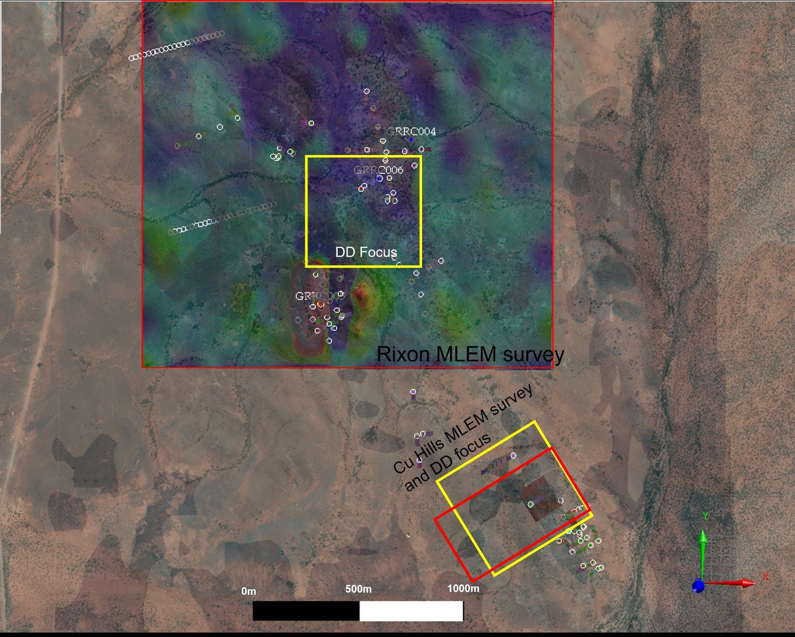
Figure 9. The Rixon and Copper Hills MLEM shown as red boxes and diamond drilling (DD) focus areas are shown as yellow boxes. The Rixon MLEM Ch. 20 results are shown. Through the transparent cover, the VTEM reprocessing can be seen as volumes.
This announcement is authorised by the Board of Peak Minerals Limited.
For personal use only
For further information please contact:
Jennifer Neild
Chief Executive Officer
Peak Minerals Limited Tel: +61 8 6143 6748
Competent Person Statement
The information in this announcement that relates to new exploration results is based on information compiled by Ms Jennifer Neild, who is a Member of the Australian Institute of Geoscientists. Ms Neild is employed by Peak Minerals Limited as Chief Executive Officer and has sufficient experience which is relevant to the style of mineralisation and type of deposit under consideration and to the activity which she is undertaking to qualify as a Competent Person as defined in the 2012 Edition of the ‘Australasian Code for Reporting of Exploration Results, Mineral Resources and Ore Reserves’. Ms Neild consents to the inclusion in this announcement of the matters based on her information in the form and context in which it appears. Ms Neild holds securities in the Company.
This information in this announcement that relates to historical exploration results were reported by the Company in accordance with listing rule 5.7 on 8 December 2020, 8 March 2021 and 18 March 2022. The Company confirms that the form and context in which the Competent Person’s findings are presented have not been materially modified from the original market announcement.
11


12 APPENDIX A: Table Summaries Drill collar locations Notable intersections from 2022 RC program For personal use only
For personal use only
Criteria JORC Code explanation Comments
Sampling techniques
•Nature and quality of sampling (eg cut channels, random chips, or specific specialised industry standard measurement tools appropriate to the minerals under investigation, such as down hole gamma sondes, or handheld XRF instruments, etc). These examples should not be taken as limiting the broad meaning of sampling.
Drilling: Reverse circulation drilling was completed with holes ranging from 60 to 65 dip. The aim of these drill holes was to set up pre collars as well as test geophysical targets within the interpreted Lady Alma Igneous Complex. Handheld XRF was used to determine anomalous zones where sampling was increased from 4m composites to 1m cyclone samples.
Moving Loop Electromagnetic Survey: A total 33.7 line km was surveyed at 200m line spacing using the SmarTEM 24 receiver and EMIT Fluxgate B Field Sensor. The configuration used a TTX2 100A/250V transmitter and had a 100m x 100m loop diameter. The system was continually calibrated with data undergoing QAQC daily.
Downhole Electromagnetic Survey: The surveys were conducted using the EMIT DigiAtlantis system and a DRTX 200V 100A EM transmitter. The readings were recorded at 10m intervals with 2 5m infill down hole through sharp anomalies. The survey used 300m x 300m loops.
•Include reference to measures taken to ensure sample representivity and the appropriate calibration of any measurement tools or systems used.
•Aspects of the determination of mineralisation that are Material to the Public Report. In cases where ‘industry standard’ work has been done this would be relatively simple (eg ‘reverse circulation drilling was used to obtain 1 m samples from which 3 kg was pulverised to produce a 30 g charge for fire assay’). In other cases, more explanation may be required, such as where there is coarse gold that has inherent sampling problems. Unusual commodities or mineralisation types (eg submarine nodules) may warrant disclosure of detailed information.
Drilling:
Samples were sent to the lab based on anomalism present from handheld XRF. Where anomalism was present, 1m samples from the rig mounted cyclone were submitted to the lab. A buffer zone around all anomalous zones was also sampled at 1m intervals. Where no anomalism was present, 4m composited samples were collected using a spear.
Drilling:
Samples were collected using industry standard practices, either off the rig mounted cyclone or by spear from the drill pile for composite samples. All care was taken to ensure a representative sample of each meter. The samples were prepared at the laboratory with a 0.25g sample prepared for the 4 acid multi element digest and a 50g lead charge for gold analysis.
13
APPENDIX B: JORC Code, 2012 Edition – Table 1
Section 1 Sampling Techniques and Data (Criteria in this section apply to all succeeding sections)
Drilling techniques
For personal use only
Drill sample recovery
•Drill type (eg core, reverse circulation, open hole hammer, rotary air blast, auger, Bangka, sonic, etc) and details (eg core diameter, triple or standard tube, depth of diamond tails, face sampling bit or other type, whether core is oriented and if so, by what method, etc).
•Method of recording and assessing core and chip sample recoveries and results assessed.
•Measures taken to maximise sample recovery and ensure representative nature of the samples
•Whether a relationship exists between sample recovery and grade and whether sample bias may have occurred due to preferential loss/gain of fine/coarse material.
A truck mounted, Reverse Circulation (RC) slimline drill rig was used with a Sullair 1350/500 compressor. The face sampling hammer had a 4 inch drill bit.
Sample recovery was assessed qualitatively with sample moisture, bulk recovery and quality recorded for each sample.
Samples were collected off the rig mounted cyclone directly into calico sample bags. Where possible, samples were collected dry, Composite samples, were collected using a spear from the centre of the drill pile. The 1m calico sample from the cyclone is securely stored until laboratory results are returned.
No known relationship between sample recovery and assay grade can be determined from the limited drilling completed. It is possible that wet samples are not representative of the material being analysed. However, data is not being used to calculate a resource and recoveries have been recorded against each sample for future use
Logging
•Whether core and chip samples have been geologically and geotechnically logged to a level of detail to support appropriate Mineral Resource estimation, mining studies and metallurgical studies.
•Whether logging is qualitative or quantitative in nature. Core (or costean, channel, etc) photography.
Drill holes were geologically logged in their entirety and of a quality sufficient for inclusion in a mineral resource estimation.
Logging is both qualitative and quantitative in nature and captures the downhole depth, colour, lithology, texture, alteration, mineralisation, and other features of the samples where present.
•The total length and percentage of the relevant intersections logged. All drill holes were logged in their entirety.
Sub sampling techniques and sample preparation
•If core, whether cut or sawn and whether quarter, half or all core taken.
•If non core, whether riffled, tube sampled, rotary split, etc and whether sampled wet or dry.
No diamond core was collected.
Samples were collected every meter directly off the rig mounted cyclone into a calico sample bag. The 1m samples that are not anomalous based on pXRF analysis are securely stored if needed. The cyclone was cleaned regularly. A majority of the samples were dry. 4m composite samples were collected from the centre of the 1m pile by a spear.
•For all sample types, the nature, quality and appropriateness of the sample preparation technique.
•Quality control procedures adopted for all sub sampling stages to maximise representivity of samples.
•Measures taken to ensure that the sampling is representative of the in situ material collected, including for instance results for field duplicate/second half sampling.
ALS Laboratory, up to 3kg of sample is pulverised to <75μm.
QAQC reference samples and duplicates were routinely submitted with each sample batch. Additionally, the QAQC from the laboratory was also collected.
Duplicate samples were routinely submitted every 25 samples.
14
For personal use only
Quality of assay data and laboratory tests
•Whether sample sizes are appropriate to the grain size of the material being sampled.
•The nature, quality and appropriateness of the assaying and laboratory procedures used and whether the technique is considered partial or total.
The sample sizes taken are appropriate relative to the style of mineralisation and analytical methods undertaken.
All samples were sent to ALS laboratory for multi element analysis (4 Acid digestion with ICP MS and ICP AES finish) and Au, Pd, and Pt analysis (30g lead fire assay with ICP AES finish). This method is appropriate for characterisation of lithogeochemistry. All samples that exceeded the upper limit of detection were analysed for Ore Grade Cu by 4 acid digestion with an ICP finish.
•For geophysical tools, spectrometers, handheld XRF instruments, etc, the parameters used in determining the analysis including instrument make and model, reading times, calibrations factors applied and their derivation, etc.
Drilling: Field XRF was utilised to assist with identification of anomalous zones and to verify visual assessments. No values are reported.
Moving Loop Electromagnetic Survey:
A total 33.7 line km was surveyed at 200m line spacing using the SmarTEM 24 receiver and EMIT Fluxgate B Field Sensor. The configuration used a TTX2 100A/250V transmitter and had a 100m x 100m loop diameter. The system was continually calibrated with data undergoing QAQC daily.
Downhole Electromagnetic Survey:
The surveys were conducted using the EMIT DigiAtlantis system and a DRTX 200V 100A EM transmitter. The readings were recorded at 10m intervals with 2 5m infill down hole through sharp anomalies. The survey used 300m x 300m loops
•Nature of quality control procedures adopted (eg standards, blanks, duplicates, external laboratory checks) and whether acceptable levels of accuracy (ie lack of bias) and precision have been established.
Drilling: For all sampling, CRMs were utilised every 20 samples with every 5th CRM being a blank. Duplicates were collected every 25 samples. In addition, QAQC data from the lab is also collected.
Verification of sampling and assaying
•The verification of significant intersections by either independent or alternative company personnel.
•The use of twinned holes
•Documentation of primary data, data entry procedures, data verification, data storage (physical and electronic) protocols.
Significant results are considered to be: >0.3% Cu, >0.3% Ni, >1g/t Au, >500 ppb Pt, Pd.
No twinned holes were drilled.
Data was capture in field books and put into digital spreadsheets. Data was checked and verified. Digital files were imported into the PUA electronic database. All physical sampling sheets are filed and scanned electronically.
•Discuss any adjustment to assay data. No adjustments were made to the assay data
Location of data points
•Accuracy and quality of surveys used to locate drill holes (collar and down hole surveys), trenches, mine workings and other locations used in Mineral Resource estimation.
The location of all collars was by handheld GPS that is accurate to within ±5m. Downhole surveys were completed by a gyro.
Downhole Electromagnetic Survey:
The surveys were conducted using the EMIT DigiAtlantis system which includes a downhole probe and that can determine the XYZ location of each measurement taken.
15
For personal use only
Data spacing and distribution
•Specification of the grid system used. All collars quoted in this Report are using the GDA1994 MGA, Zone 50 coordinate system.
•Quality and adequacy of topographic control. Topography based on publicly available data.
•Data spacing for reporting of Exploration Results.
•Whether the data spacing and distribution is sufficient to establish the degree of geological and grade continuity appropriate for the Mineral Resource and Ore Reserve estimation procedure(s) and classifications applied.
The data spacing is not appropriate for a Mineral Resource or Ore Reserve estimation. Samples were collected to test for mineralisation.
The aim of the drill program was to test geophysical targets identified from the MLEM and previous HeliEM surveys. No holes were drilled to determine grade continuity. DHEM surveys were utilised to verify and further understand results.
•Whether sample compositing has been applied. No sample compositing has been applied to the exploration results.
Orientation of data in relation to geological structure
•Whether the orientation of sampling achieves unbiased sampling of possible structures and the extent to which this is known, considering the deposit type.
•If the relationship between the drilling orientation and the orientation of key mineralised structures is considered to have introduced a sampling bias, this should be assessed and reported if material.
Sample security •The measures taken to ensure sample security.
Audits or reviews
•The results of any audits or reviews of sampling techniques and data.
The drill program was completed to test geophysical targets only and set up potential diamond drill hole precollars for further testing to targets at depth, if warranted.
Moving Loop Electromagnetic Survey:
The survey was completed in an east west direction, roughly perpendicular to the overall strike of the geology.
No orientation sampling bias has been identified.
Samples were transported from the field directly to the assay laboratory in Perth
Apart from a desktop review of the historic surface and drill data, no audits have been undertaken.
16
Section 2: Reporting of Exploration Results
For personal use only
Criteria JORC Code explanation Commentary
Mineral tenement and land tenure status
•Type, reference name/number, location and ownership including agreements or material issues with third parties such as joint ventures, partnerships, overriding royalties, native title interests, historical sites, wilderness or national park and environmental settings.
The current drill program is part of the larger Green Rock Project held by Peak Minerals. It consists of ground held through two subsidaries: Greenrock Metals Pty Ltd and CU2 WA Pty Ltd.
Peak Minerals Ltd acquired 100% of Greenrock Metals Pty Ltd and thus 100% of E51/1716. E51/1716 is a granted tenement and is in full force. There are no known impediments towards the exploration and subsequent development of the Project. Greenrock Metals Pty Ltd retains a 1% NSR for all minerals sold.
Peak Minerals Ltd has acquired 100% of the shares of CU2 WA Pty Ltd. CU 2 WA Pty Ltd owns 100% interest in E51/1889 and E51/1934 which are granted tenure and are in full force. Peak Minerals has also acquired 100% of E51/1990, E51/2011 and Prospecting licenses P51/3199, P51/3200, P51/3201, P51/3202, P51/3203, P51/3204, P51/3205, P51/32019, P51/3220, P51/3221, P51/3222, P51/3223, P51/3224, P51/3225, P51/3226, P51/3227, P51/3228, P51/3229, P51/3230, P51/3231, P51/3232, P51/3233, P51/3234, P51/3235, P51/3236, P51/3237 and P51/3238.
Peak Minerals Ltd, through the 100% acquisition of CU2 WA Pty Ltd, holds the right to earn in to the base and precious metals of E51/1818 held by Technology Metals Australia’s (ASX: TMT) subsidiary The KOP Ventures (Tal Val, Target C) and E51/1832 held by Taruga Minerals Limited’s (ASX:TAR) subsidiary Taruga Gold Limited (Target B) by spending:
For E51/1818 (TMT JV):
•$1,000,000 within 2 years for 51% (Minimum $250,000 within 12 months of 26/11/2021)
•Not Less than $2,000,000 within 2 years for an additional 19% (Stage 2 earn in)
•Completion of a PFS for an additional 10% (within 12 months of completing stage 2 earn in)
For E51/1832 (Taruga Minerals JV) CU2 WA Pty Ltd also holds the right to earn in to the base and precious metals by spending:
• 50,000 for 40% (Min $25k within 6 months of 18/11/2020) for 40%
•Additional $50,000 within 24 months for 40%
Minor sections of E51/1818 and E51/1832 are covered by an exclusion around Mt Yagahong.
•The security of the tenure held at the time of reporting along with any known impediments to obtaining a licence to operate in the area.
Currently negotiating a land access agreement with the Yugunga Nya people. Access has been granted to select areas with heritage surveys completed over selected prospects. No work has been completed without the consent of the Yugunga Nya.
17
(Criteria listed in the preceding section also apply to this section)
For personal use only
Exploration done by other parties
•Acknowledgment and appraisal of exploration by other parties.
All tenements are in good standing with no known impediments.
The Green Rocks Project has been explored by numerous companies since mid 1960s with the most recent being the Silver Swan Group (2008 2012) and Mithril Resources Ltd (2014 2015) and JV partner Taruga Minerals. Exploration by Matador Mining on E51/1716 was limited to desktop assessment and rock chip and soil sampling. Previous drilling, geochemical and geophysical surveys at the Copper Hills tenement (E51/1716) has demonstrated widespread copper mineralisation. Recent surface geochemistry by Taruga Minerals has identified base metal anomalism.
Over the proejct area, reprocessing of the available geophysical coverages was completed. Further desktop review of historic data has supported the potential for magmatic copper mineralisation with data evaluation and summary still underway. Planning of additional geophysical surveys, mapping, surface sampling and drill targeting is currently underway.
•Deposit type, geological setting and style of mineralisation.
Two types of mineralisation are present at the Green Rocks Project: magmatic sulphide mineralisation associated with mafic ultramafic intrusions; and hydrothermal copper gold mineralisation, which is controlled by a north northwest trending shear zone, dipping moderately to steeply to the east. To the north the shear rotates towards more of a northwest orientation and can be traced for over 23km.
The lithologies at Green Rocks consist of multiple gabbro to peridotite units which have intruded into greenstone ultramafics. The near surface mineralisation is interpreted to be hydrothermal/structural in nature and consists predominantly of malachite with lesser chalcopyrite and pyrite ± pyrrhotite associated with quartz veining and as anastomosing thin veinlets. The presence of magmatic sulphides in historic diamond drill core at 100m+ depth indicate a magmatic source for this mineralisation.
In the east of the Green Rocks Project tenure, sedimentary horizons consisting of cherts, ironstone and BIFs are present as well as granitic intrusions
18
Geology
Drill hole Information
For personal use only
Data aggregation methods
•A summary of all information material to the understanding of the exploration results including a tabulation of the following information for all Material drill holes: easting and northing of the drill hole collar elevation or RL (Reduced Level elevation above sea level in metres) of the drill hole collar dip and azimuth of the hole down hole length and interception depth hole length.
All drill hole locations are described in the tables above, in the body of the text and on related figures.
Relationship between mineralisation widths and intercept lengths
•If the exclusion of this information is justified on the basis that the information is not Material and this exclusion does not detract from the understanding of the report, the Competent Person should clearly explain why this is the case.
•In reporting Exploration Results, weighting averaging techniques, maximum and/or minimum grade truncations (eg cutting of high grades) and cut off grades are usually Material and should be stated.
•Where aggregate intercepts incorporate short lengths of high grade results and longer lengths of low grade results, the procedure used for such aggregation should be stated and some typical examples of such aggregations should be shown in detail.
•The assumptions used for any reporting of metal equivalent values should be clearly stated.
•These relationships are particularly important in the reporting of Exploration Results.
•If the geometry of the mineralisation with respect to the drill hole angle is known, its nature should be reported.
•If it is not known and only the down hole lengths are reported, there should be a clear statement to this
No information material to the understanding of the exploration results has been excluded.
Significant intersections are determined using both qualitative (i.e., geological logging) and quantitative (i.e., lower cut off) methods. The nominal lower cut off for copper is 0.3% and 0.22% for nickel in this report.
Any high grade sulphide intervals internal to broader zones of sulphide mineralisation are reported as included intervals.
No metal equivalence data are reported.
Assay intersections are reported as down hole lengths. At this time the widths of mineralisation have not yet been determined.
The geometry of the mineralisation below surface is not fully understood at this time.
All intervals are reported as down hole length, true width of mineralisation is not yet known.
19
For personal use only
Diagrams
effect (eg ‘down hole length, true width not known’).
•Appropriate maps and sections (with scales) and tabulations of intercepts should be included for any significant discovery being reported These should include, but not be limited to a plan view of drill hole collar locations and appropriate sectional views.
Balanced reporting •Where comprehensive reporting of all Exploration Results is not practicable, representative reporting of both low and high grades and/or widths should be practiced to avoid misleading reporting of Exploration Results.
Other substantive exploration data
•Other exploration data, if meaningful and material, should be reported including (but not limited to): geological observations; geophysical survey results; geochemical survey results; bulk samples size and method of treatment; metallurgical test results; bulk density, groundwater, geotechnical and rock characteristics; potential deleterious or contaminating substances.
Relevant maps and diagrams have been included in the body of this report.
Further work
•The nature and scale of planned further work (eg tests for lateral extensions or depth extensions or large scale step out drilling).
All results, greater than 0.3% copper, 0.3% nickel, 1g/t Au and 500ppb Pt, Pd are included in this report with dilution up to 1m in some intervals.
Drilling: All other relevant data has been included within this report.
Moving Loop Electromagnetic Survey: Any geophysical images shown in the body of the announcement show intensity relative to surrounding data. Any modelled data presented in this announcement is based on predictions (models) of the geophysical response of sub surface features using industry standard methods and measured and assumed input parameters. A degree of uncertainty is therefore associated with these models.
Downhole Electromagnetic Survey: All material or meaningful data collected has been reported.
The results from this program indicate that there massive sulphide is not present within 350m of surface this was known. The purpose of these holes was confirm the response and get a better understanding of the mineralisation. A full compilation of all geophysical data collected, including historical data available is being compiled to understand and target the mineralisation.
Once the compilation is completed, a decision on further drilling will be made that best targets the prospective areas.
•Diagrams clearly highlighting the areas of possible extensions, including the main geological interpretations and future drilling areas, provided this information is not commercially sensitive.
A map noting the sample locations has been included. A schematic geological interpretation has been provided but will be further refined as more data becomes available.
20