SecondaryPlanofLondonOntario


Policy & Guidelines: Government, Urban & Suburban Municipalities
Group 6:
Somdat Tularam
Prakash Dhakal
Navleen Kaur
Merin Jolly

The City of London may create a secondary plan when it is necessary to elaborate on the London Plan's parent policies or when it is crucial to coordinate the development of several sites. Secondary plans will enable a thorough examination of a secondary planning area, taking into accountalloftheenvironmentalandcitybuildingpoliciesofthisplan. Additionally, it will give rise to the possibility of developing a coordinated planning strategy for the secondary planning area and offering more specific policy guidance for the region that goes beyondTheLondonPlan'soverarchingprinciples.
The City may adopt new Secondary Plans by amendment to the current development Plan, and add these Secondary Plan areas to Schedule “D” – Planning Areas, in accordance with the provisions of Section 19.2 of the Official Plan.The following Secondary Plans have been adopted byCouncil:
i)LondonPsychiatricHospitalSecondaryPlan(OPA510)
ii)SouthwestAreaSecondaryPlan(OPA541)
iii)OldVictoriaHospitalLandsSecondaryPlan(OPA586)
iv)RiverbendSouthSecondaryPlan(OPA613)
v)McCormickAreaSecondaryPlan(OPA629)

vi)Beaufort/Irwin/Gunn/Saunby(BIGS)NeighbourhoodSecondaryPlan(OPA646
(WhereOPAstandsforOFFICIALPLANAMENDMENT)
BACKGROUND
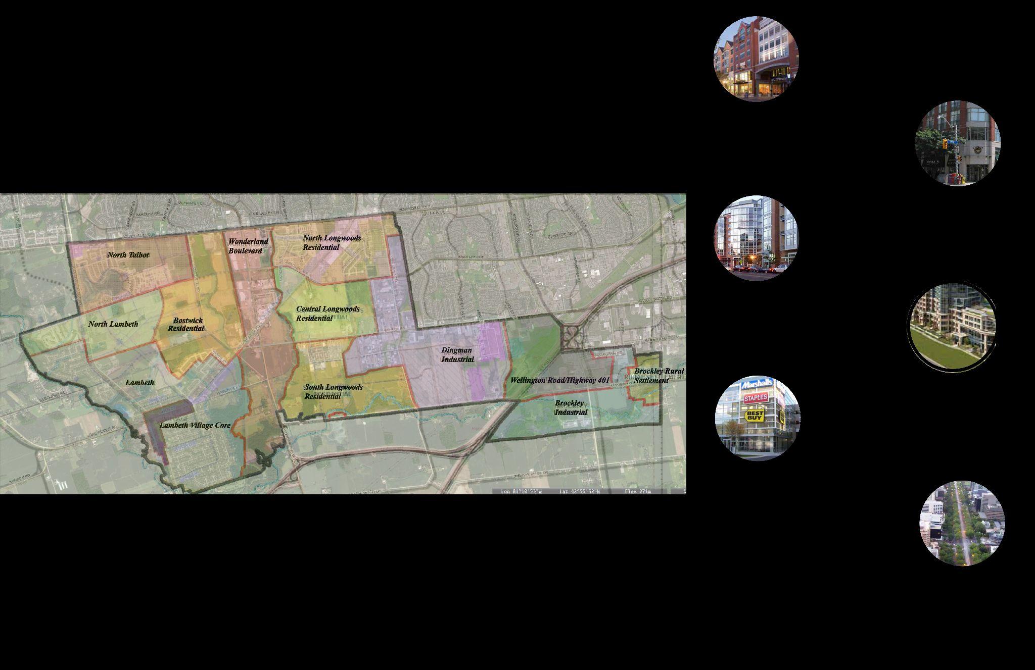
SouthwestAreaSecondaryPlan
The Southwest Planning Area will be developed as a vibrant community that includes a significant city gateway, elements of mixed-use development, an increased range and density of residential built form, sustainability, preservation of significant cultural heritage resources, walkability, and high-quality urban design, accordingtotheSecondaryPlan.
BOUNDARIES


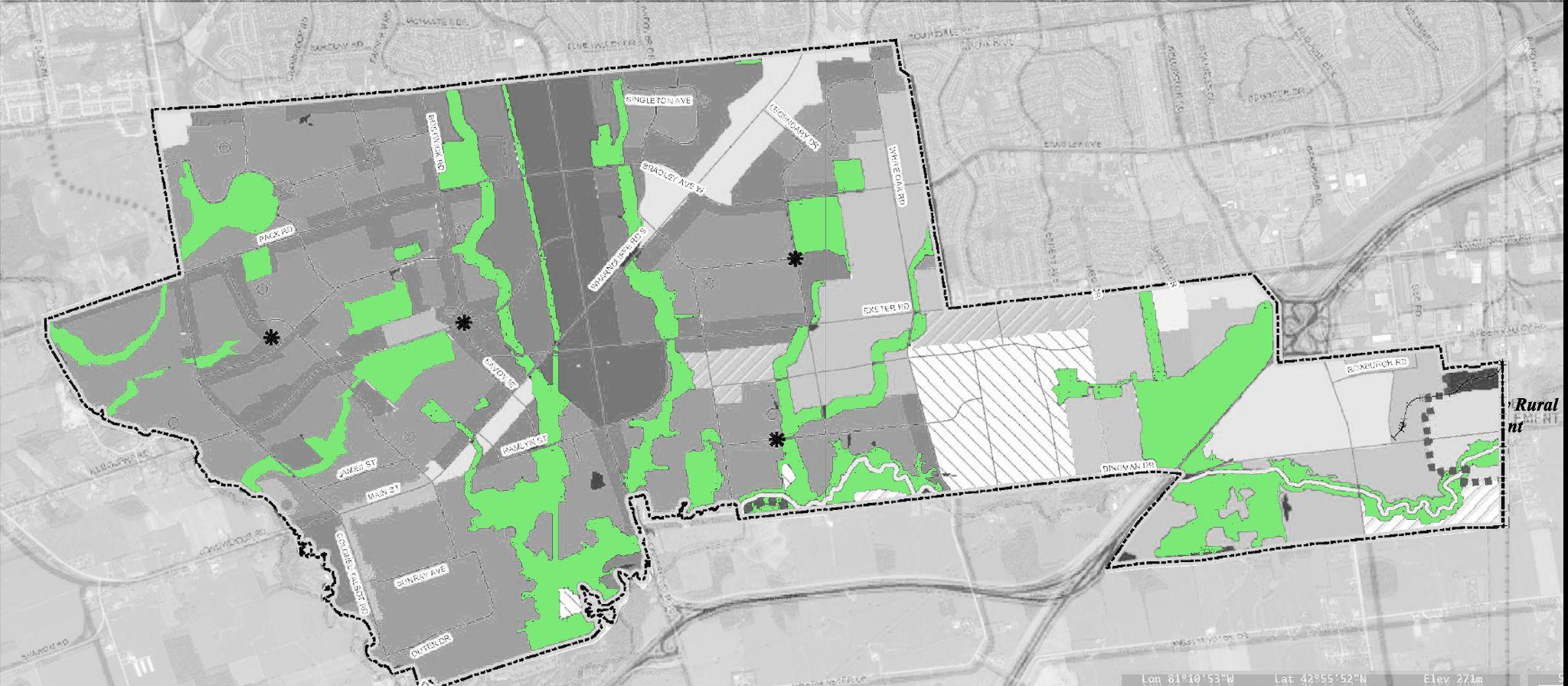
The Southwest Area Secondary Plan covers the lands in the southwest part of the City of London, which is bounded by Southdale Road West, White Oak Road, Exeter Road, Wellington Road South, GreenValley Road and the Urban Growth Boundary identified on Schedule “A”oftheOfficialPlan.

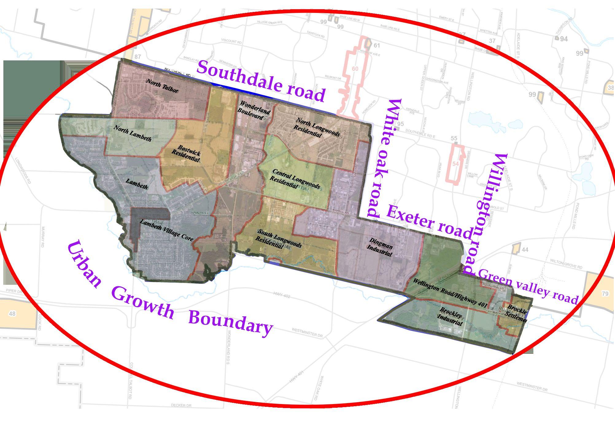
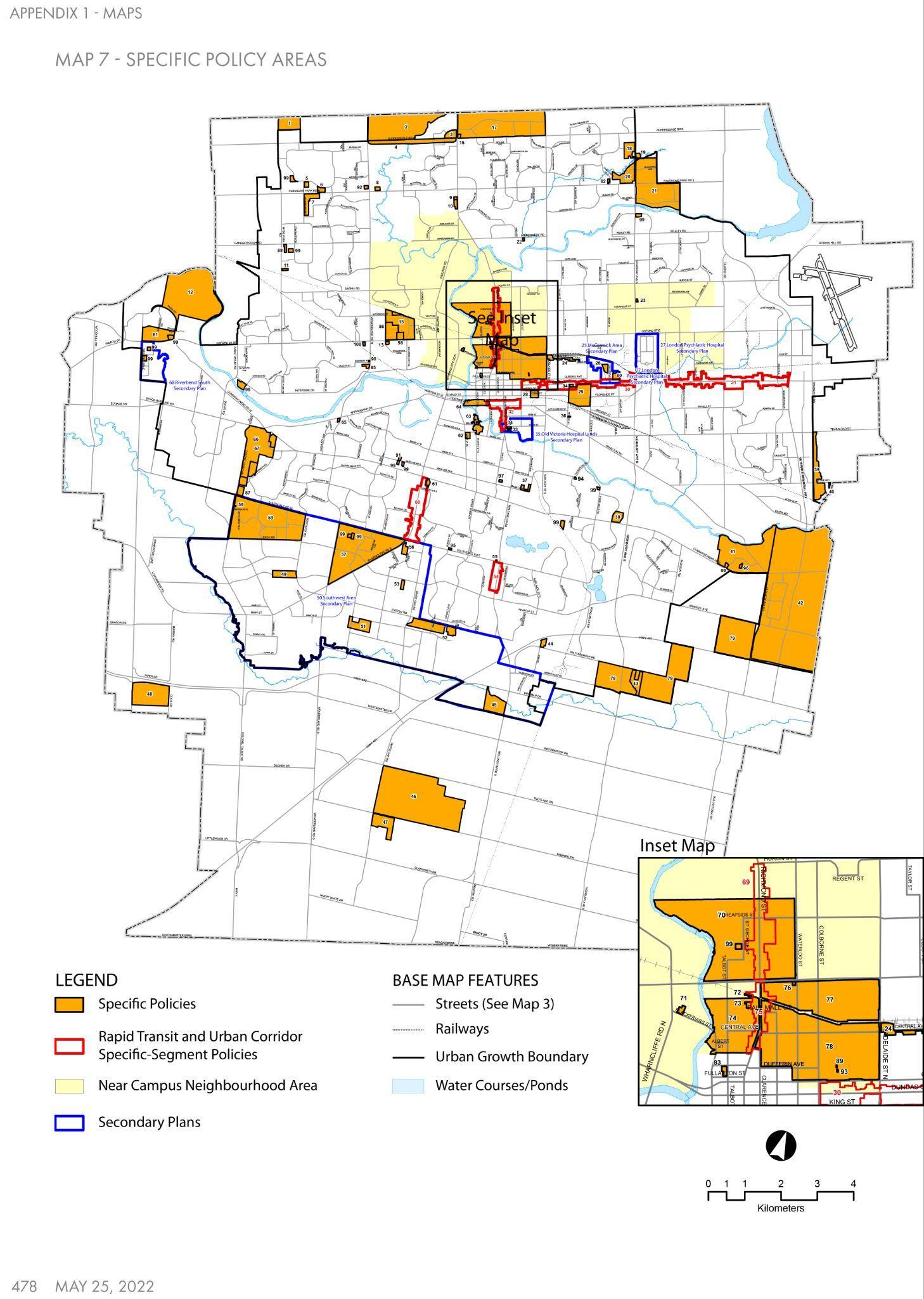 Fig.SouthdaleRoadwest
TIMELINEOFSTUDY

[1] In the february of 2009, Council for the City (“City Council” or “Council”) initiated the process of establishing a significant area plan for the southwest partoftheCity.Itwasthefirstsuchplanundertakenby theCityinaconsiderableperiodoftime.
[2] Over the next three years and nine months, a number of open houses, workshops and meetings were held to obtain input from affected and interested parties and a number of iterations of the plan itself were prepared.
ReporttoPlanning Committee recommending approvalofthe Terms-of Reference.
Informationreportto Planning Committee on the landowner interviews, public visioningsessionand stakeholder workshop held in MayandJune
Report to Planning Committee on the releaseofthedraft Southwest Area Plan report and associated background studies.
Report to Planning Committee on the public comments received on the draft Southwest Area Plan report, preferred land useplan,andassociated backgroundstudies
[3] On November 20, 2012, following completion of this extensive consultative process, City Council approved the Southwest Area Secondary Plan (“SWAP” or “Plan”) by adopting Official Plan Amendment 541 (“OPA 541”). Among other things, OPA541addedSWAPtothelistofAdoptedSecondary Plansins.20.2oftheCity’sOfficialPlan(“CityOP”).
Nov 20, 2012
Council approved The Plan
June 18, 2012
April 30, 2012
Dec 12, 2011
Information report to Planning and Environment Committee on proposedrevisedlanduseconcept plan,theproposedamendmentsto Schedules“A”–LandUse,“B-1”
– Natural Heritage Features, and “C” - Transportation of the City Official Plan, and the draft SecondaryPlanfortheSouthwest Area.
Information report to StrategicPrioritiesand Policy Committee on the Southwest Area Plan Servicing Strategy and how it fits into the City‟s Growth Management Implementation Strategy(GMIS)
InformationreporttoPlanning and Environment Committee onhowfourkeypublicissues identified by Council have been addressed, including servicingandphasingstrategy; andtoobtainCouncildirection tocirculatetherevisedSWAP plan to the public for review andfeedback.
Timeline
9, 2009 June 20, 2009 April 26, 2010
13, 2010
Feb
Sept
VISION

TheSouthwestAreaSecondaryPlanopensupawholenewworld ofpossibilitiesforthecity'ssouthwestsector.Thesouthwest quadrantofthecity'sdistinctivecharacteristicsarehighlightedin thisinnovativeandforward-thinkingplan,whichalsoemphasises thepromotionofsustainablegrowthpatterns,attractiveurbanism, strongneighbourhoods,thepreservationofsignificantnatural heritagefeatures,andbuiltandculturalheritage.
Themainvisionofthesouthwestareasecondaryplanincludesthe creationofnewneighbourhoodthatpromotes:
➔ amixofuses,anddiversemixofresidentialhousing;
➔ emphasisondesignparameterswithplacemakingfeatures;
➔ walkabilitywithinandbetweenneighbourhoods;
➔ theintegrationoftheNaturalHeritageSystemasanopportunity forresidentstoenjoy;and,
➔ NeighbourhoodCentralActivityNodesasdestinationplacesin theneighbourhood
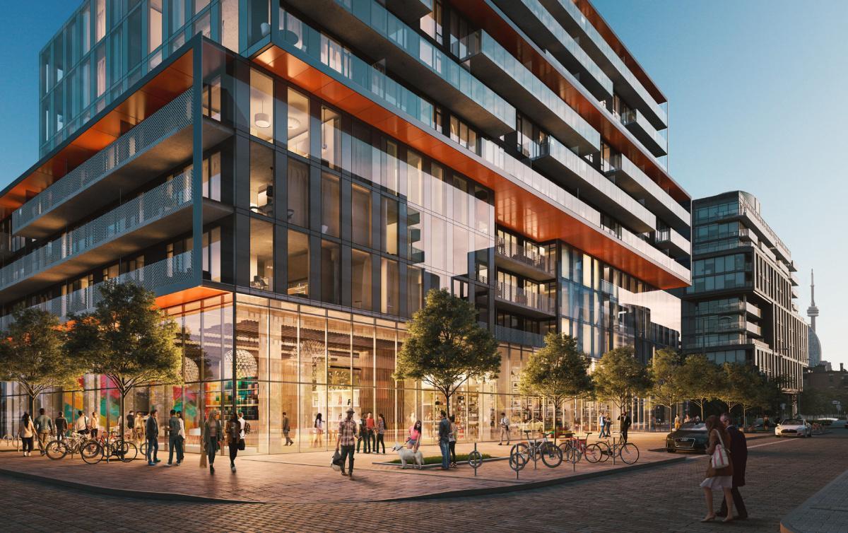
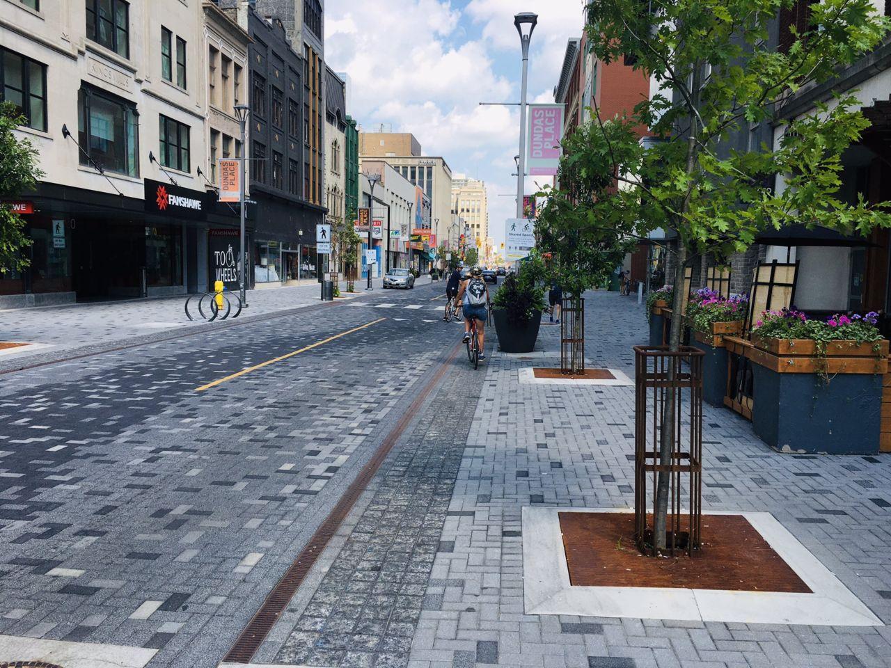
Fig.Exampleofamixeduseneighbourhood
LowDensityResidential
● Aminimumdensityof15unitsper hectare.Aresidentialdensityexceeding 30unitsperhectaremaybepermitted throughasite-specificzoningby-law amendment,
MediumDensityResidential
● Minimumdensityof35unitsperhectare. b)Buildingheightsshallgenerallynotbe permittedtoexceedsixstoreys.
● Aresidentialdensityexceeding75units perhectare(upto100unitsperhectare)
HighDensityResidential
● Newdevelopmentmaybepermittedtoa maximumdensityof150unitsperhectare andamaximumbuildingheightof12 storeys,subjecttofurtherurbandesign reviewatthesiteplanapprovalstage
Commercial/MixedUse
● Thebuiltformshallbeofalow-riseheight, andhaverooflinesconsistentwithor complementarytothe“village”
● ThemaximumtotalGrossFloorAreafor specificuseswithineachbuildingshallbe300 squaremetres.Considerationofindividual usesupto500squaremetresmaybe consideredaspartofaZoningBy-law Amendment.
Industrial
● RegulationsintheZoningBy-lawshall includeprovisionsrequiringbuildingsand structurestobelocatedaminimumof40 metresfromtheBrockleyRuralSettlement boundary.
● Enhancedplantingsshallbeprovidedwithin the40-metresetbacktoprovideavisual screenbetweenindustrialandsensitiveland uses.
BUILTFORM BUILTFORMPOLICIES
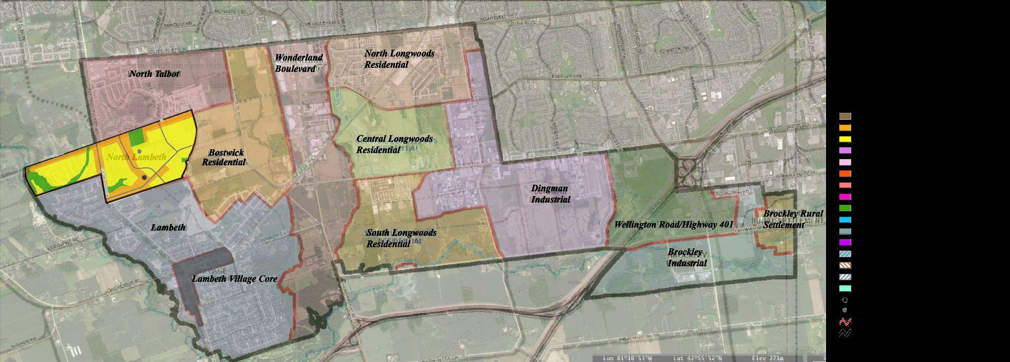
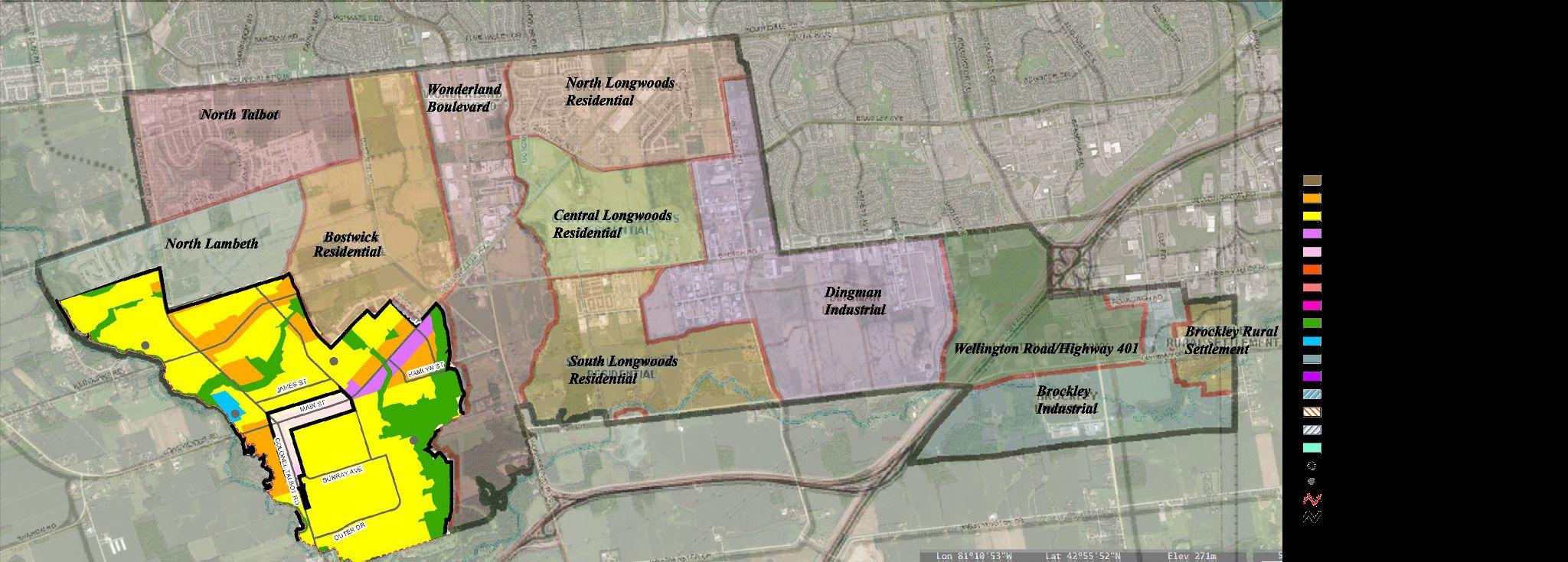
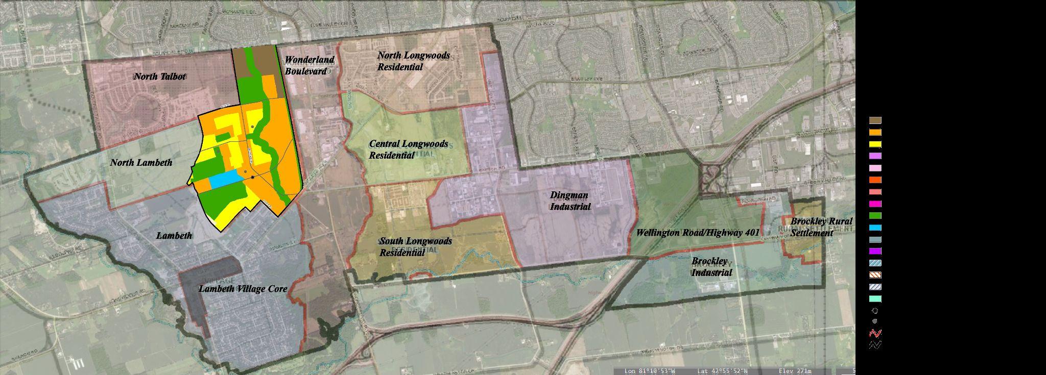
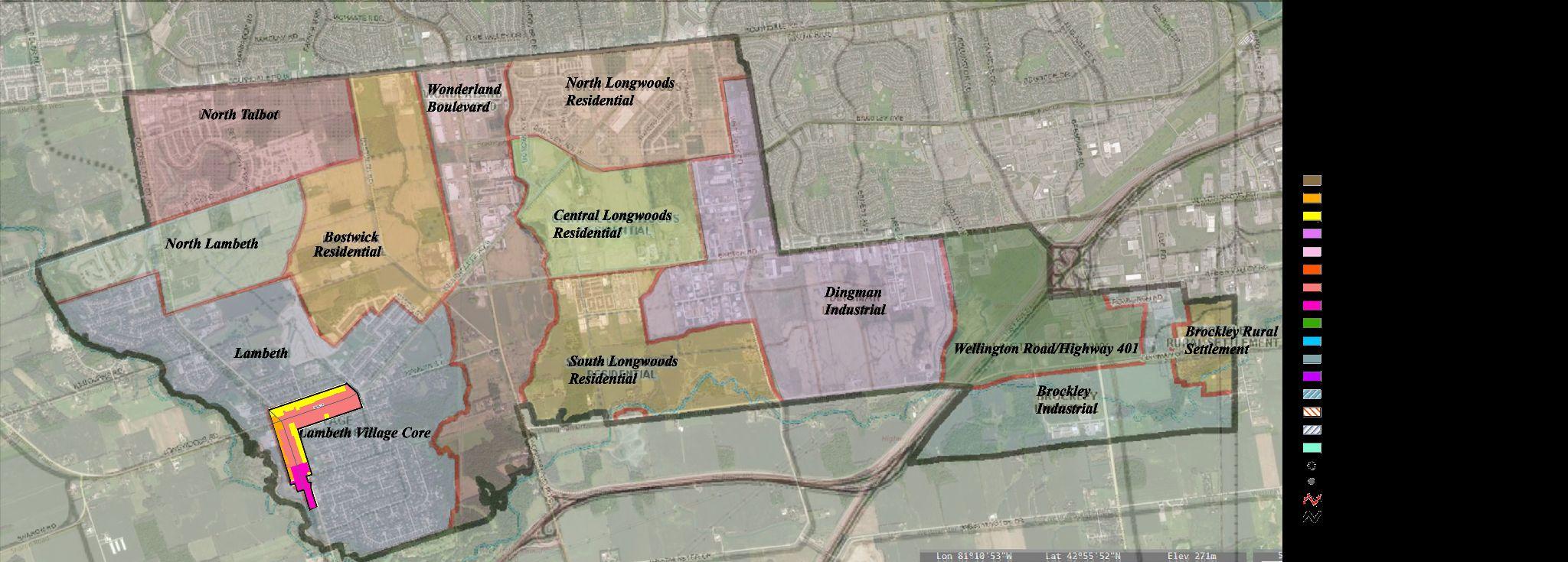
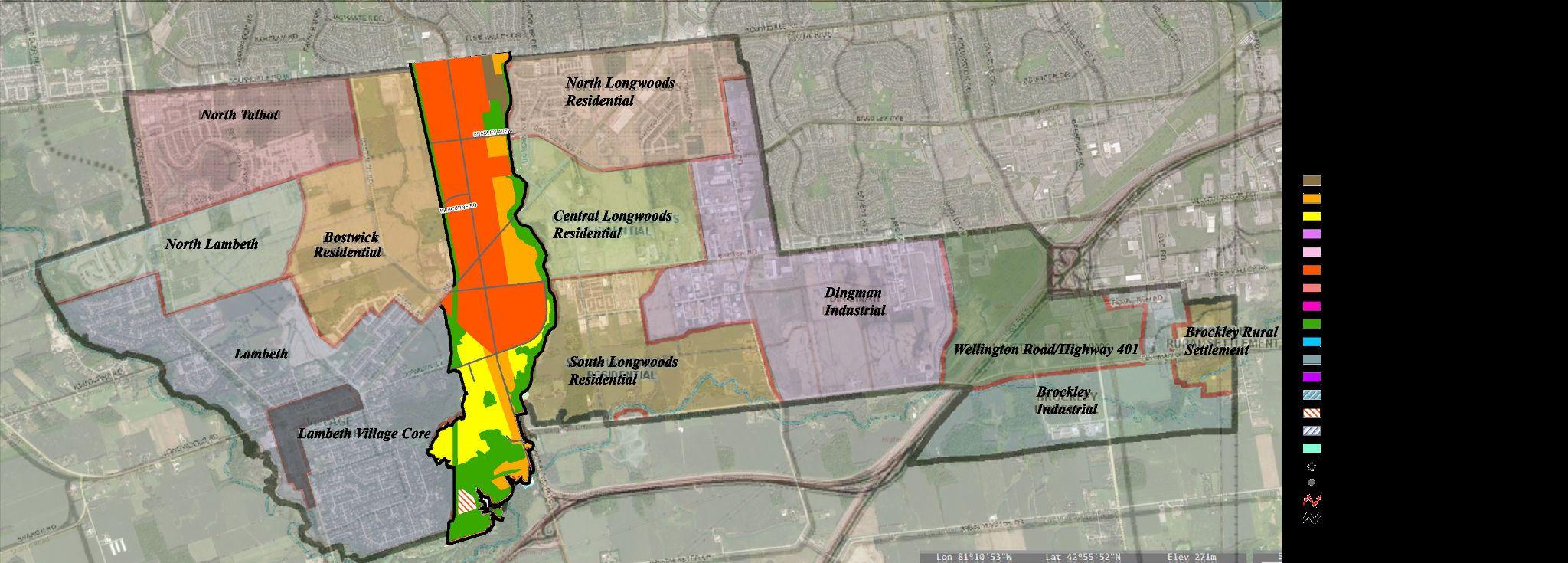
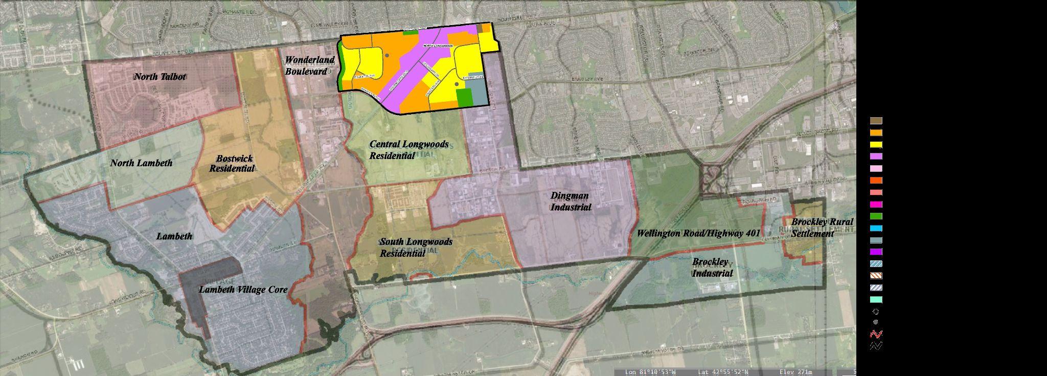
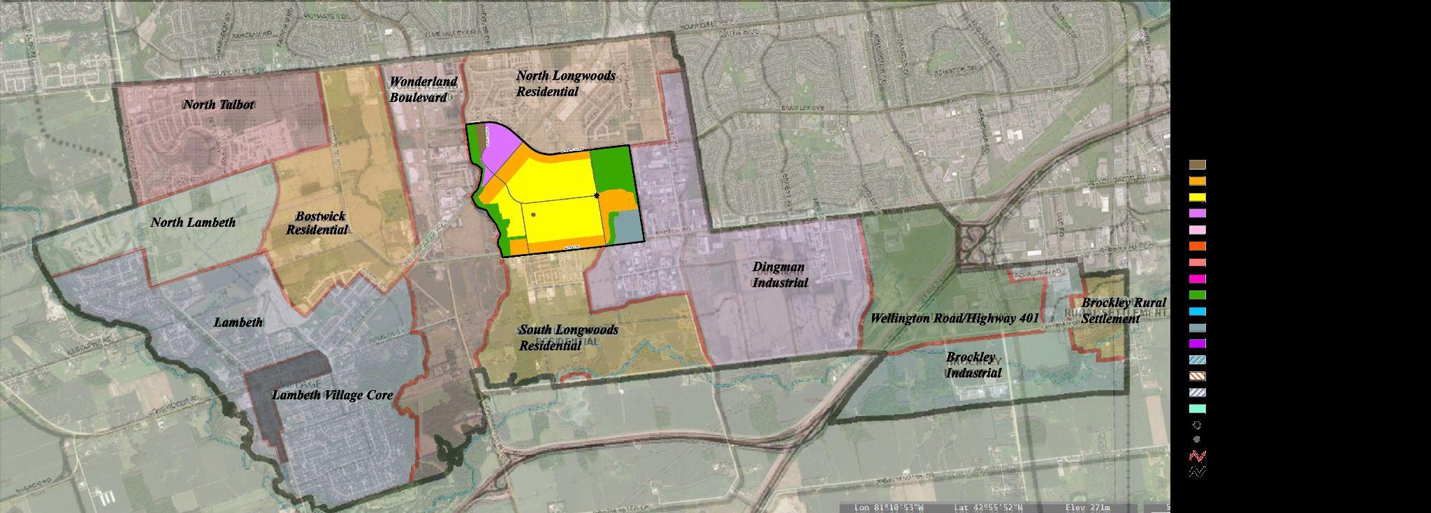
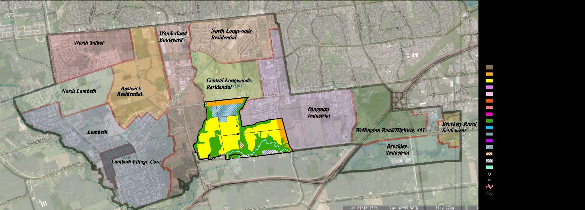
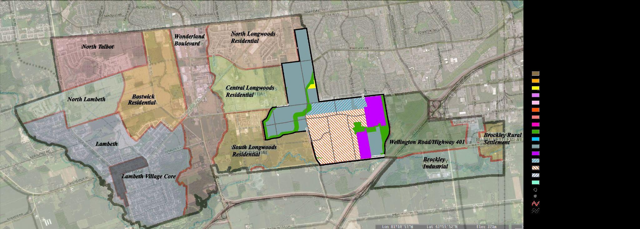
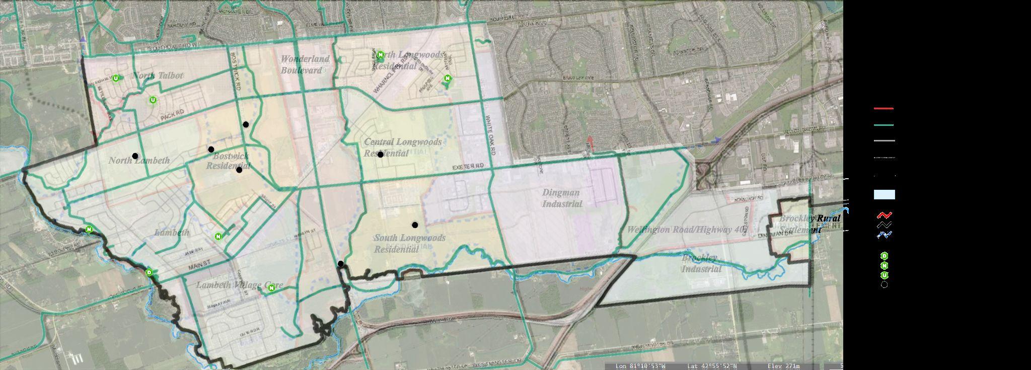
LANDUSEPLAN
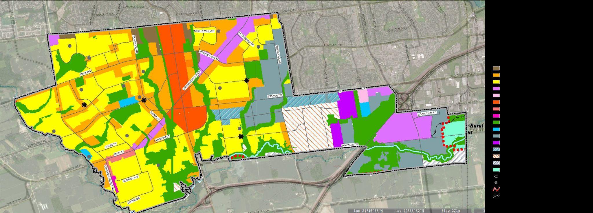
LANDUSEDESIGNATIONS
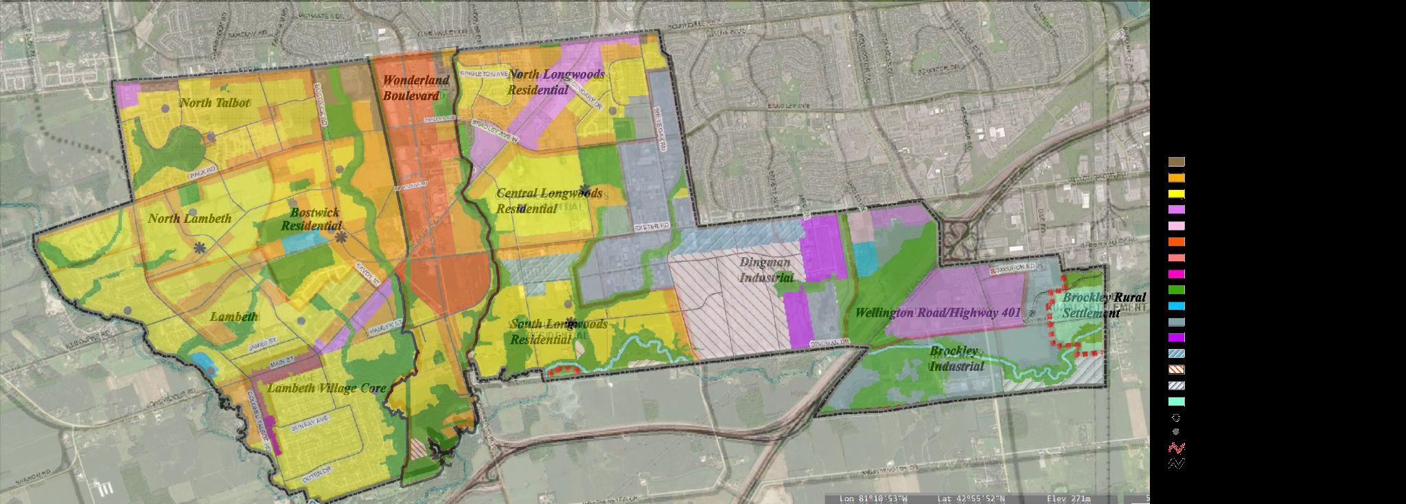

LANDUSEDESIGNATIONS
LANDUSEDESIGNATIONS
LANDUSEDESIGNATIONS
LANDUSEDESIGNATIONS
LANDUSEDESIGNATIONS
LANDUSEDESIGNATIONS
LANDUSEDESIGNATIONS
LANDUSEDESIGNATIONS
LANDUSEDESIGNATIONS
LANDUSEDESIGNATIONS
LANDUSEDESIGNATIONS
LANDUSEDESIGNATIONS
LANDUSEDESIGNATIONS
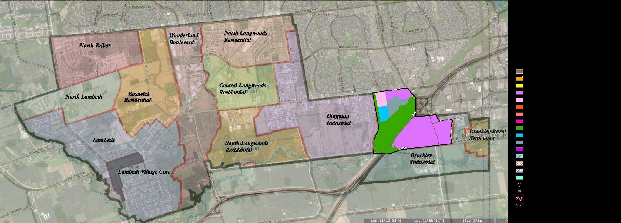
STRUCTUREPLAN
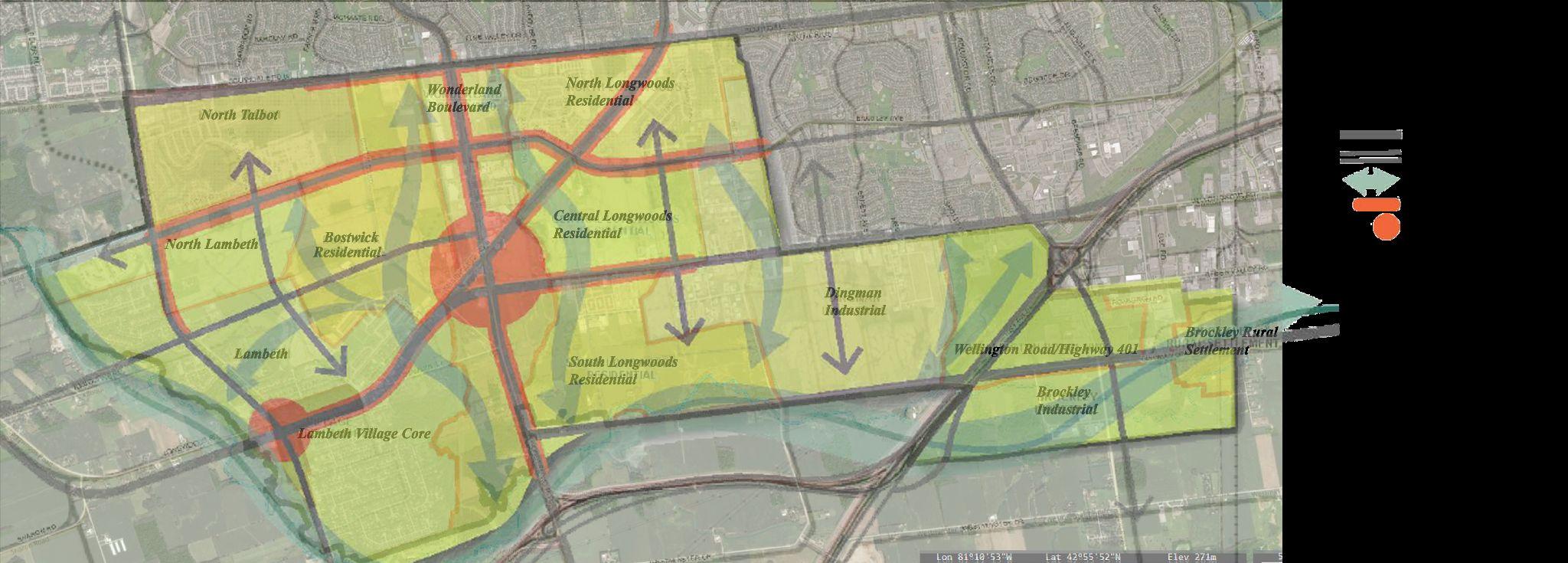
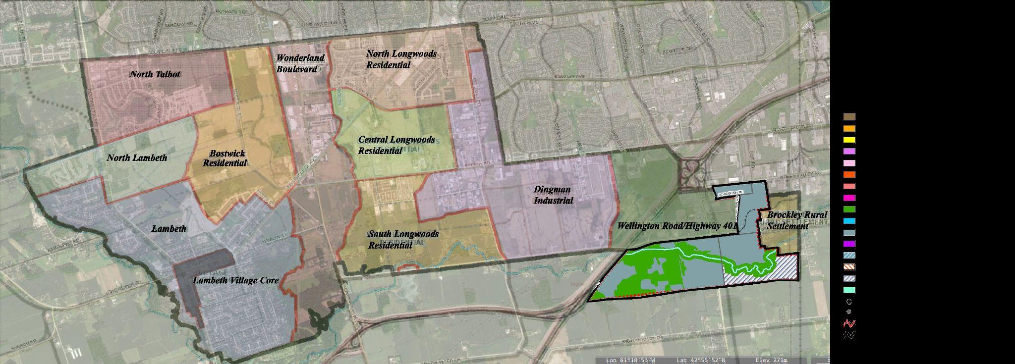
MOBILITYPLAN
MOBILITY

ThemobilityplaninthesouthwestSecondaryPlanofLondonentailsdevelopinga comprehensivestrategytoimproveconnectivity,expandtherangeofavailabletransport alternatives,andsupportsustainablemodesoftransportwithinthespecifiedregion.To provideadditionallinkagestotheneighbouringcommunities,localstreetsmayjoin suitablyplannedmainroadways.
● Theroadwaylayoutsmustpromotepedestrian-orienteddevelopmentpatternsand haveacloselinktotheSouthwestPlanningArea'snaturalheritageassets.
● TheuseofCommonElementsCondominiumsshouldbeconsideredforthe ownership,useandmaintenanceofcommonlanewaysanddriveways.
● Onlocalroadways,thereshouldbeplanted"bump-outs"bigenoughto accommodateboulevardtreestobreakuplongperiodsofon-streetparking.
● Onlocalandsecondarycollectorroadways,specialdesigntreatmentsmustbeput intoplaceattheproperareastolimitorrestricttrafficmovementsandgive precedencetopedestrianmovements.
Priortotheright-of-waybeingdevelopedasalocalroadway,theCitymayengageintoan encroachmentagreementwiththepropertyownerforitsusage.Whenafuturelocal roadwayright-of-wayisneededforroadconstruction,thepropertyownerandtheCity mightagreetotransferit.
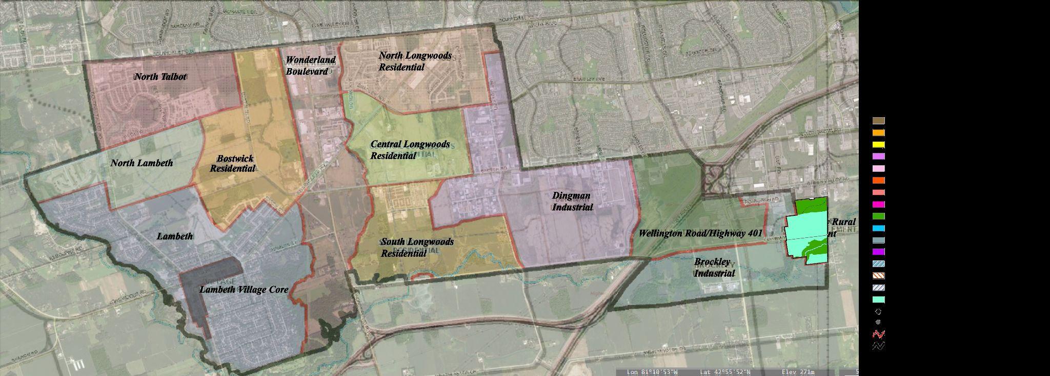
PUBLICREALMPLAN&POLICIES

The SouthwestArea Plan played a crucial role in shaping the urban design outcomes of the planning area and its surrounding neighborhoods. The following were the generalpoliciesthatguidedthedevelopmentprocesswithinthestudyarea.Thefollowingweregeneralpoliciesthatappliedtotheentirestudyarea:
● The focus was on developing sustainable and livable communities through principles such as compact, pedestrian-oriented design and specific areas for mixed-use development. The incorporation of the Open Space System with interconnected trails and prioritizing public safety and accessibility to open spaces,parks,andschoolswerekey.
● Parks, CentralActivity Nodes, and public areas served as central meeting places. Building density and land use along transit routes supported efficient transit services.Concentratingcivicandinstitutionalstructuresinspecificlocationsenhancedcommunityidentityandfunctionality.
● Consistentdesignandplacementofstreetfurnitureisnecessarytoavoidclutter.Streetscapedesignprioritizespedestrianandcyclistcomfortandsafety.
● Street trees and optimal planting environments should be provided. Landscape walls or features at community/subdivision entrances are prohibited. Public Realm Design Guidelines can provide additional guidanceforpublicrights-of-way.
By emphasizing mixed-use development, a modified grid road system, and an interconnected open space network, the plan created a dynamic and accessible environment. The integration of cultural heritage resources, the establishment of central meeting places, and the consideration of public safety further contributed to the success of the plan. Overall, the SouthwestArea Plan left a lastingimpactontheurbanfabric,showcasingtheCityofLondon withprideandenhancingthequalityoflifeforitsresidents.
PARKS&OPENSPACEPLAN&POLICIES

Among the policies, those pertaining to parks and open areas were crucial in developing thriving and livable communities. To guarantee the availability of neighborhood and district parks in close proximity to residential developments, the plan placed an emphasis on transforming publicly owned open spaces into linear parks with adequate bufferstobuiltareas.
● Active parkland and play areas were distributed and balanced appropriately within an 800-meter radius of new residential projects, avoiding major obstacles like railways,rivers,andmainroads.
● Urban parks, with places for passive recreation, pathways, substantial hardscaping, and public art, were located during subdivision and/or site plan approval. Theseparkswereobtainedbyparklanddedicationatthetimeofdevelopmentandcouldtaketheshapeofurbansquares,parkettes,orvillagegreens.
● A minimum area of 2,500 square meters was often required for urban parks, which was decided through the development approval procedure. Within the SouthwestPlanningArea'slimits,afuturecommunitycenterwasplannedtobebuiltthatwouldserveasbothaneighborhoodandcommunityfacility.
● The Council would choose the actual location through a differentsiteselectionprocedure.Tosafeguardandimprove natural historical elements, neighborhood and district parks would be integrated close to or adjacent to them as part of thesubdivisiondesignandapprovalprocess.
Inordertoavoidbarrierslikerailwaysandmajorroads,parklandand play areas were strategically positioned within an 800-meter radius of new residential buildings. Through the donation of parkland, urban parks were created, providing areas for passive relaxation and public art. District and neighbourhood parks were integrated next to natural heritage items.An analysis of parkland maintenance funding tookintoaccountprospectivecondofeerevenue.
CULTURALHERITAGEPOLICIES
In the southwest quadrant of the city, the Southwest Area Secondary Plan lays out a forward-thinking strategy to development that emphasizes sustainable expansion, the protection of natural and cultural heritage, and the development of varied and interconnected communities. The following are the guidelines for the overall development strategy as well asthepoliciesforculturalheritagepreservation:
● CreationofaDiverseandConnectedCommunity
● ARangeofHousingChoices
● ACompetitivePlacetoWorkandInvest
● AGreenandAttractiveEnvironment
● AModelofSustainableGrowthManagement
The design promoted a variety of land uses, encouraged community contact, improved current communities, and integrated the new community with neighboring neighborhoods in accordance with the objective of building a diversified and linked community. Offering a variety of housing options emphasized the need for inclusive residential communities with a varietyofhometypesanddesigns.
The plan also emphasized the preservation of natural heritage elements, the promotion of sustainable development practices, and the implementation of a rational and cost-effective growth management strategy. The plan aimed to preserve cultural history, promote sustainable growth, and highlight the special features of the city's southwest region through theseregulations.
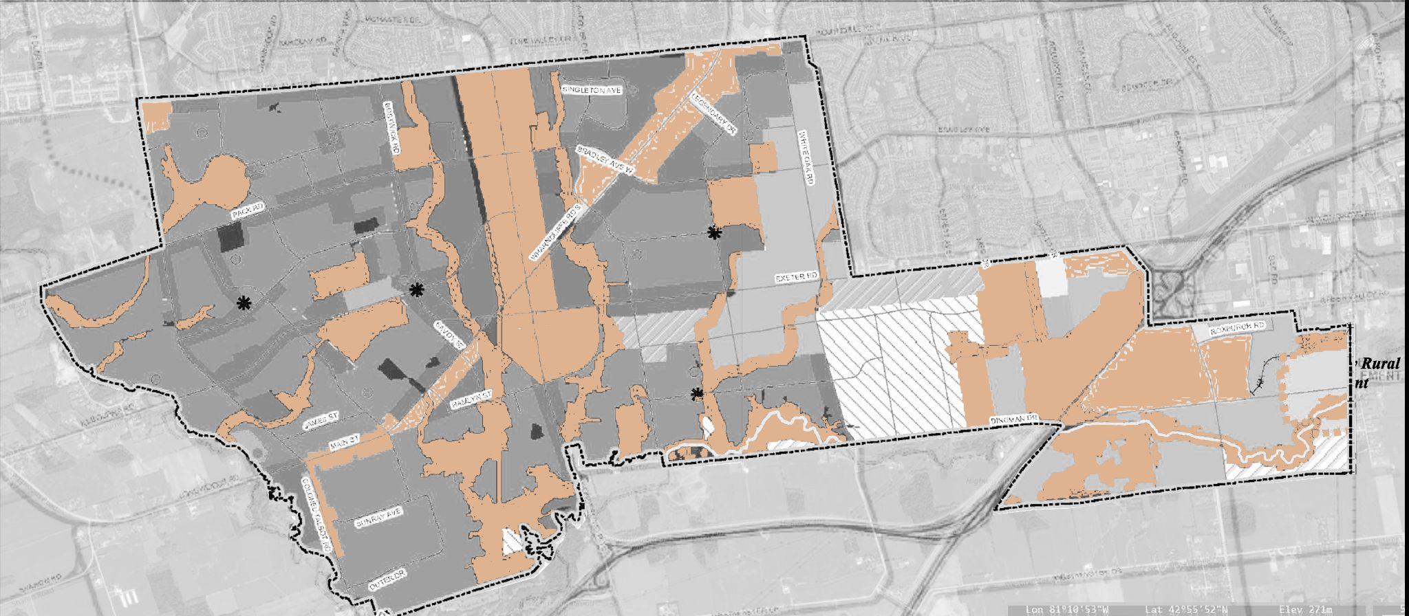
NATURALHERITAGEPOLICIES
As part of the secondary plan process, a draft comprehensive natural heritage study was finished. The OfficialPlanSchedulesAandB-1aswellastheSchedulesoftheSouthwestAreaPlanincludethenatural heritagesystemcomponentsfromtheDraftNaturalHeritageStudy.
InadditiontotheregulationsinSection15oftheOfficialPlan,thefollowingregulationsareapplicable:
● The width of the Dingman Creek Corridor, the Dingman Creek Significant River Corridor, and othernaturalheritagefeaturesareallpartsofthenaturalheritagesystem.
● GrowthRestriction
AssessingthenecessityofanEnvironmentalImpactStudy(EIS)
Identifyingandconfirmingnaturalfeatures
Settingupecologicalbuffers
TheOpenSpacesystembeingintegrated

Ecologicalbuffersareusedorpurchased.
● Encouraging the planting of native species, improving tree planting in outside side yards, adhering to tree planting recommendations in landscape designs, and stewardship activities for builtareasnearbuffers.
Various measures were implemented to manage growth, including assessing the need for an Environmental Impact Study (EIS), identifying and confirming natural features, establishing ecological buffers,integratingtheOpenSpacesystem,andutilizingoracquiringecologicalbuffers.
Standards were also put in place for tree planting and good stewardship practices. Examples included promoting the planting of native species, enhancing tree planting in exterior side yards, following tree planting recommendations in landscape designs, and conducting stewardship activities in developed areas nearbuffers.
IMPLEMENTATIONS PRINCIPLES


TheSouthwestAreaSecondaryPlanshallbeimplementedutilizingthe followingimplementationmechanisms:
● Allmunicipalworksshallbeconsistentwiththepoliciesofthis Plan;and,
● Allplanningapplicationsshallbeconsistentwiththepolicies ofthisPlan.
DevelopmentPhasingandServicing
Anapproachtoservicingandphasingforthesouthwestisproposed whichrecognizestheservicingstrategiesthathavebeenestablishedand approvedforlandsinpreviouslyapprovedAreaPlans.Servicingforthe southwestwillbeconsistentwiththeservicingstrategyfortheCityas thewhole.
ImplementingPublicRealmPlan
Creatingavisionandframeworkforboostingthequality,usefulness, andaestheticsofpublicplaceswithinthespecifiedregionispartof developingapublicrealmplanforLondon,Ontario'ssouthwest secondaryplan.
● PublicSpaceOrganisation
● ImplementationStrategy
● MonitoringandEvaluation
● DesignGuidelines
ThepreparationofthisSecondaryPlanhasbeenguidedbyaseriesof principlesandobjectivesthataredescribedbelow.Anychangestothis SecondaryPlanmustadheretotheseprinciples.
● CreationofaDiverseandConnectedCommunity:Create inclusive,varied,anddistinctivecommunitieswitharangeof usesandhighlevelsofconnectednessforpossibilitiesin multimodaltransportation.
● ARangeofHousingChoices:Ensurethateachcommunity hasavarietyofhousingtypes,densities,andarchitectural styles.
● ACompetitivePlacetoWorkandInvest:Provideforthe growthofemploymentlandsopportunities.
● AGreenandAttractiveEnvironment:Integratethe constructedenvironmentwiththenaturalenvironmentto highlighttheSouthwestPlanningAreaasasuperior,master planned,andprotectedenvironment.
● AModelofSustainableGrowthManagement:Incorporate sustainabilityintotheexpansionoftheSouthwestPlanning Areainacost-effectiveandefficientmanner.
REFERENCES
● https://london.ca/government/council-civic-administration/master-plans-strategies/plans-strategies
● https://pub-london.escribemeetings.com/filestream.ashx?DocumentId=5397
● https://lfpress.com/2016/11/02/southwest-area-plan-long-years-of-planning-for-londons-undeveloped-southwest-are-giving-way-to-construction
● https://earth.google.com/web/search/southdale+road+east+london/@42.94332124,-81.22825346,276.79838037a,0d,53.49263371y,265.97276672h,84.44333713t,0r/data=CigiJgok
CUaQboJShkVAEQkdgxZZZ0VAGSC0E6Z3SlTAIel9PdWcU1TAIhoKFk9FMmtUY2huU2NDNVh3R1JCU0MtZFEQAg
● https://london.ca/sites/default/files/2020-05/London_Ontario_Skyline_2017_%28cropped%29.jpg
● https://www.londontourism.ca/mediafiles/hero/hero-banner8.jpg

● https://images.squarespace-cdn.com/content/v1/58bd840415d5db65361af13b/1494266084353-QZZOYSAR2FT3GK74TYYU/IMG_0793.jpg?format=2500w
● https://www.londontourism.ca/mediafiles/uniquenaturalareas6.jpg
● https://london.ca/sites/default/files/2020-09/2019%20Strategic%20Plan.pdf
● https://london.ca/sites/default/files/2021-03/UPDATED-2019-12-South-West-Area-Plan_AODA.pdf
● https://urbantoronto.ca/forum/attachments/1599160734860-png.267582/
