Ways to Earn Your Required 24 Continuing Education Credits
1. Earn hour-for-hour continuing education credits by completing board-approved FSMS courses or seminars.
2. Earn up to 6 continuing education credits per biennium by attending local chapter, state or national professional meetings.
3. Earn 2 continuing education credits per day of attendance at meetings of the Board of Professional Surveyors and Mappers.
4. Earn 6 continuing education credits for each semester hour of a completed course in a “surveying and mapping subject” at a regionally accredited university or college.
5. Earn up to 10 continuing education credits by researching, writing and publishing a book, paper or article related to surveying and mapping.
6. Up to twelve (12) continuing education credits earned beyond the required twenty-four (24) may be carried forward to the following renewal period. (5J17.041, F.A.C.)
7. Newly licensed PSMs are not required to earn continuing education before their first license renewal. (5J-17.041(4), F.A.C.)
The F lorida Surveyor is the official publication of the Florida Surveying and Mapping Society, also known as FSMS. It is published monthly for the purpose of communicating with the professional surveying community and related professions who are members of FSMS. Our award winning publication informs members eleven months out of the year about national, state, and district events and accomplishments, as well as articles relevant to the surveying profession. In addition, continuing educational courses are also available.
PRESIDENT’S Message
October 16th, 2024 Members,
We have just experienced and witnessed what two horrific Cat 3 & 4 Hurricanes can do to our State in a 3-week period. The devastation, flooding and interruption in our lives, our businesses, and our overall health and well-being cannot be understated.
Our thoughts, prayers, and well wishes for and to all of those affected come from the heart and we want you to know that we are there for our members. The Executive Committee and the Board have increased our Disaster Relief Fund (which was at $12k+) another $20k in emergency funding immediately, with the option of increasing it to $50k if needed.
Please reach out and let us know which members are in the most need and fill out the form on our website so we can review and address them as quickly as possible. We realize this is a trying time for all those affected, but please provide enough detail and documentation so we can make an appropriate assessment. We would like to be able to help as many as possible.
Our members, all of you out there, are what makes us strong and we want to ensure that you know we stand with you to help where and when w e can.
In this edition of the Florida Surveyor, we are adding the newest Strategic Plan which was put together and fine-tuned and prioritized from our meeting back in April. Even though there are many items in this that are important to our future, we have prioritized certain items that are most needed and agreed upon.
1. Because of the Deregulation issues that we successfully won again with the help of our terrific Lobbying firm and our Legislative committee; we need to look forward for next round on this issue which is not going aw ay.
PRESIDENT’S Message
Our FSM PAC Fund has become more important than ever before to play this political game we’re in. We addressed this at the Strategic Plan meeting and are convinced that it needs to stay properly funded to the tune of $50k+ every year to address these matters as they come up. We need to be proactive in this and stop being reactive. Like it or not, we have to play politics and be able to have personal relationships with important Legislators that will have our backs and understand what Surveyors are, how we contribute to the economy and the protection of the Public.
We do that by having a close association of our Legislative Committee and our lobbyist who provides us vital information on who needs to be supported and can provide us the best bang for our hard earned money. Push came to shove last year, and our FSM PAC fund was woefully inadequate to provide enough funds needed to support our allies in Tallahassee. So, a call went out and spread through word of mouth that we needed at least 20 long time members to provide $2500 each in emergency funds and to do this within 2 weeks. It was accomplished and we met this important goal, strengthening critical relationships and supporting election campaigns.
Our message to all members out there, is to please look for ways to add funds to our FSM PAC on a continual basis, fundraiser’s, clay shoots, picnics, fishing tournaments, and provide suggestions and ideas.
2. Chapter 472 and Standards of Practice needs to open and the language fixed and clarified in some areas to lessen the ability of others to try to deregulate us because of the current wording. The only way to do this properly and more safely is with the help of our regulatory board; Florida Board of Surveyors and Mappers, to open it. They would like us FSMS to come up with the appropriate language changes and that we all agree to before any attempt is done.
We have set this as a priority in the coming year to work on that language and be proactive and be ready for the next round.
These are the two top priorities, but please read through the plan and ask questions.
Respectfully submitted,
Richard D. Pryce
2024-25 Districts and
Directors
District 1 - Northwest
Bay, Calhoun, Escambia, Franklin, Gadsden, Gulf, Holmes, Jackson, Jefferson, Leon, Liberty, Madison, Okaloosa, Santa Rosa, Taylor, Wakulla, Walton, Washington
Professional Practice Committee Lou Campanile, Jr.
Workforce Development Committee Lou Campanile, Jr.
Liaisons
CST Program Alex Jenkins
FDACS BPSM Don Elder
Surveyors in Government
Academic Advisory UF
FES
Richard Allen
Justin Thomas
Lou Campanile, Jr.
Practice Sections
Geospatial Users Group
Young Surveyors Network
Richard Allen
Melissa A. Padilla Cintrón, SIT
Strategic Plan - Adherence Review
Goal 1: “Enhance, Improve, and Defend the Professional Image of Surveyors and Mappers.”
Objective A:
1. Strongly defend and enhance the definition of surveying and mapping in Chapters 472, 177 and 718, Florida Statutes.
2. Keeping deregulation or dilution of 4-year degree mandate from occurring is a primary goal.
Objective B:
1. Workforce Development: support and assist in education programs to develop the next generation workforce (licensed professionals and technical support personnel).
Objective C:
1. Advocate for the surveying and mapping profession to be recognized as a foundation to a broader spectrum of disciplines that includes engineering, environmental, geological, geospatial, geographic information systems (GIS), remote sensing and other growing sectors of the geospatial community.
Established during Stategic Planning Meeting — April 2024
Goal 2: “Expand & Strengthen Legislative Committee Involvement on Government Affairs.”
Objective A:
1. Legislative plan of action for future battles in 2025 and beyond.
Objective B:
1. Advocate for legislation, regulations and government policies that promote and enforce use of the qualificationsbased selection process (Consultants Competitive Negotiation Act – CCNA) for selection of provision of surveying and mapping services.
Objective C:
1. Work with NSPS to create a direct communication between FSMS and NSPS national government affairs and other NSPS state affiliates.
Objective D:
1. Foster greater individual and sustaining firm member participation in state government affairs efforts.
Established during Stategic Planning Meeting — April 2024
Goal 3: “Enhance FSMS Communications Activities to Engage All Membership Classifications More Effectively within FSMS and Allied Associations.”
Objective A:
1. Improve existing communication vehicles and establish new media and means of communications among members.
Objective B:
1. Increase the use of new and traditional media to disseminate news and information about FSMS, and our members, to the public.
Goal 4: “Grow & Strengthen FSMS as a Valuable Professional Society & Improve Its Value to the Members.”
Objective A:
1. Strengthen the role of FSMS as the voice of the geospatial profession in Florida.
Objective B:
1. Represent the clear majority of professional surveyors and mappers in the State of Florida.
Objective C:
1. Create a venue and forum for special interest groups of surveyors and mappers within FSMS.
1. Boundary Survey Preservation Database through FSMS sponsored Web-Based GIS. (Long Term) (This objective was added at the end of the Strategic Planning Meeting)
2. Background from Brian Murphy: There is an aging population of boundary surveyors throughout Florida, many of whom have tremendous amounts of invaluable records and surveys. Additionally, despite the surveying industry’s best efforts to make it a requirement, recordation of surveys is largely unenforceable, with the governing agency already being stretched thin. Thus, there are many areas throughout Florida where Certified Corner Records for Section corners just are not filed. When a survey company goes out of business, the typical result is that their records are either destroyed, or they are sold to another company. As companies continue to merge and get acquired by larger, publicly traded companies, these records are at increasing risk of not having a perceived value by the corporate world. Additionally, data requests to companies with records from other surveyors can at times be burdensome to the recordholding company’s overhead, and other surveyors are at the mercy to the level of altruism of the companies holding the records.
3. CASE STUDY: The Florida Surveying and Mapping Society can help perform an invaluable offering, by collaborating
FLORIDA SURVEYING AND MAPPING SOCIETY,
STRATEGIC PLAN
with organizations and agencies like the FDEP, Florida Geographic Data Library, the University of Florida’s map and Imagery Library, and the National Archives, to seek methods to help preserve, index and georeference these surveys into an online, web-based GIS. Creating a consortium to assist in the digitization, indexing and preservation of these records will assist in the placing these important documents into a domain that would be able to be accessed by FSMS Members, creating an invaluable resource as a part of their membership.
Established during Stategic Planning Meeting — April 2024
Frontier Precision has the latest LiDAR photogrammetry innovations to fit your job or application. Our staff has the knowledge and real-world experience to help you select the solution that’s best for you and the training to make you more proficient and profitable. Just as important, our professional services group can help you implement LiDAR and photogrammetry solutions on your next project – from field data capture to data processing – we have the expertise to make sure your project is done right.
The YellowScan LiDAR UAV delivers the highest level of accuracy and density for real-time georeferenced point cloud data. Lightness and accuracy combine for a LiDAR solution that works hard for you.
Emesent automates the collection and analysis of data in challenging GPS-denied environments, delivering revolutionary efficiency, safety, and operational insights to underground mining and other industries. It’s core areas of expertise are drone autonomy, SLAM-based LiDAR mapping, and data analytics.
round the State A
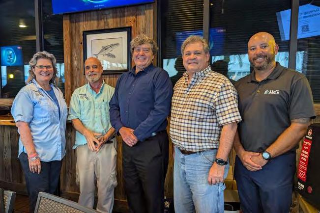
Central Florida Chapter Meeting (September 17th, 2024)
The officers of the Central Florida Chapter of FSMS for the coming year (from left to right), Betty Morris (Treasurer), Ray Phillips (President), Chris LaBerge (Secretary), Ralph Nieto (VP), and Eddie Munoz Jr. (President Elect).
Central Florida Chapter Meeting (September 17th, 2024)
Katie Britt, Assistant Director for Geomatics Extension at UF/IFAS School of Forest, Fisheries, and Geomatics Sciences, presenting "Surveying Workforce Development Symposium." This is a 1 Credit CEU attempting to identify and address specific professional surveying needs. Check with your Chapter President to see when she will be presenting at your local Chapter.
Central Florida Chapter Meeting (October
15th, 2024)
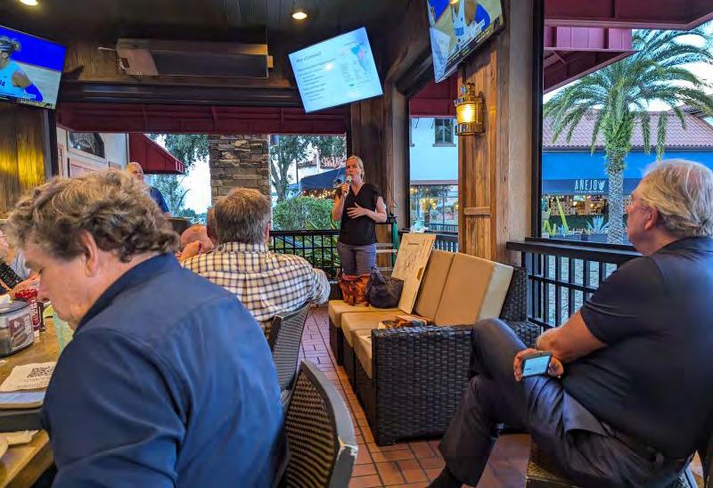
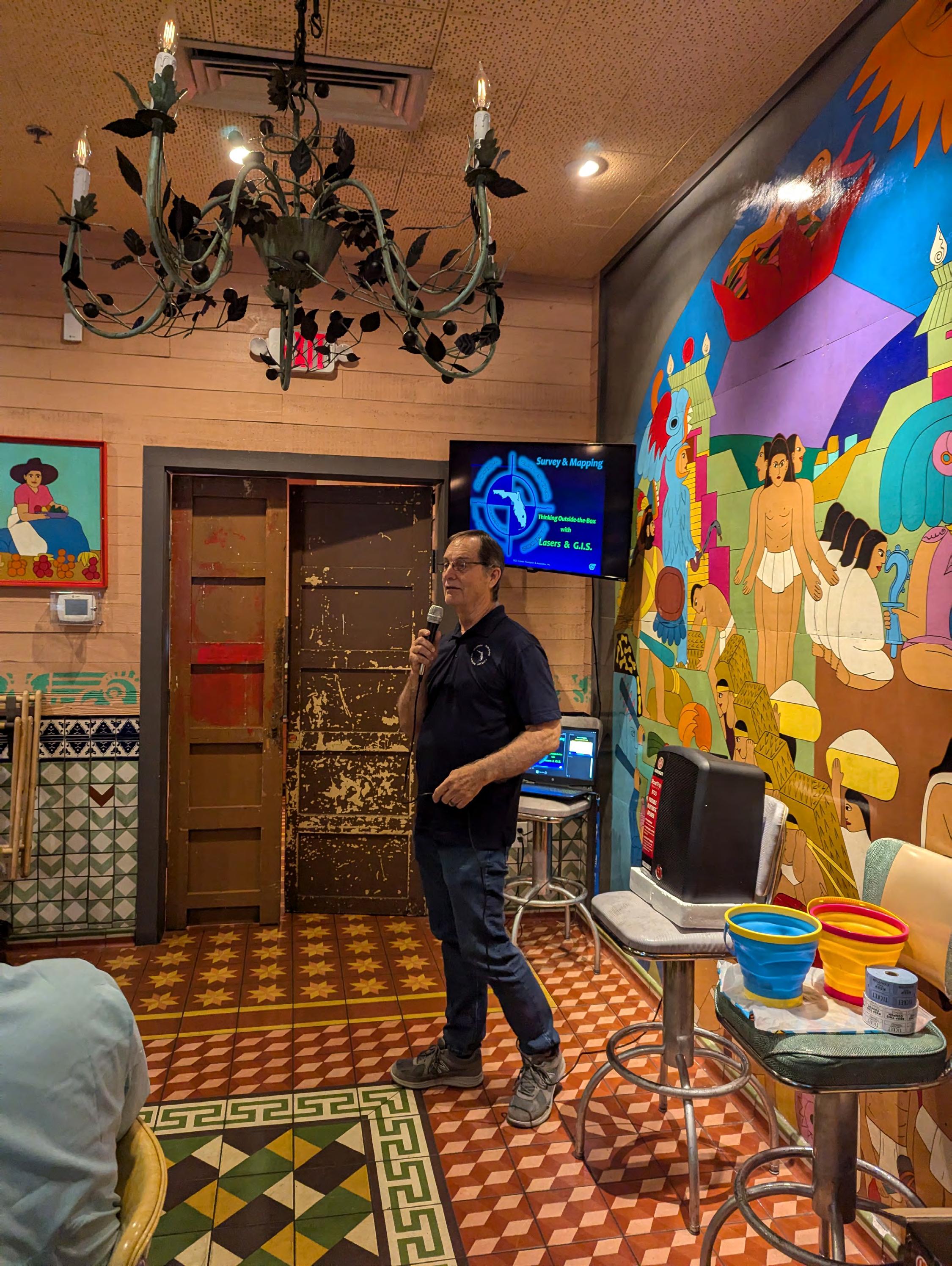
2024-25 President Rick Pryce presents a continuing education seminar titled, "Thinking Outside the Box with Lasers and GIS" to the Central Florida Chapter.
202 4 S u S taining
A
AA Surface Pro, Inc.
239-471-2668
A. D. Platt & Associates, Inc.
850-329-5551
AIM Engineering & Surveying
239-332-4569
Allen & Company, Inc.
407-654-5355
Allen Engineering
321-783-7443
Altapro Surveyors
386-837-0244
American Government Services Corporation
813-933-3322
American Surveying, Inc.
813-234-0103
Amerritt, Inc.
813-221-5200
AOI (Area of Interest) Solutions, Inc.
321-877-0056
Arc Surveying & Mapping, Inc.
904-384-8377
ARCVERTEX LLC 631-480-2201
Ardurra, Inc. 239-292-7773
Associated Land Surveying & Mapping, Inc. 407-869-5002
ATWELL, LLC 866-850-4200
Avirom & Associates, Inc. 561-392-2594
AXIS
GeoSpatial, LLC 410-822-1441
BBarnes, Ferland and Associates, Inc. 407-896-8608
Barraco & Associates, Inc. 239-461-3170
Bartram Trail Surveying, Inc. 904-284-2224
Bello & Bello Land Surveying Corporation 305-251-9606
Stephen H. Gibbs Land Surveyors, Inc. 954-923-7666
Stoner Inc. 954-585-0997
Suarez Surveying & Mapping, Inc. 305-596-1799
Survey Data Solutions, LLC
352-816-4084
SurvTech Solutions, Inc. 813-621-4929
T
T2 UES Inc.
407-587-0603
Tectonic Engineering and Surveying Consultants 845-534-5959
Thurman Roddenberry & Associates 850-962-2538
TopoDOT 407-248-0160
TranSystems Corporation Consultants 727-822-4151
UF/IFAS
352-846-0850
386-672-9515
407-839-4300 Whidden
LinkedIn = 1,553 Followers
Facebook = 1K+ Followers
X = 404 Followers
Instagram = 364 Followers
YouTube = 43 Subscribers • 16 Videos
561-790-5515 Winnigham
954-771-7440
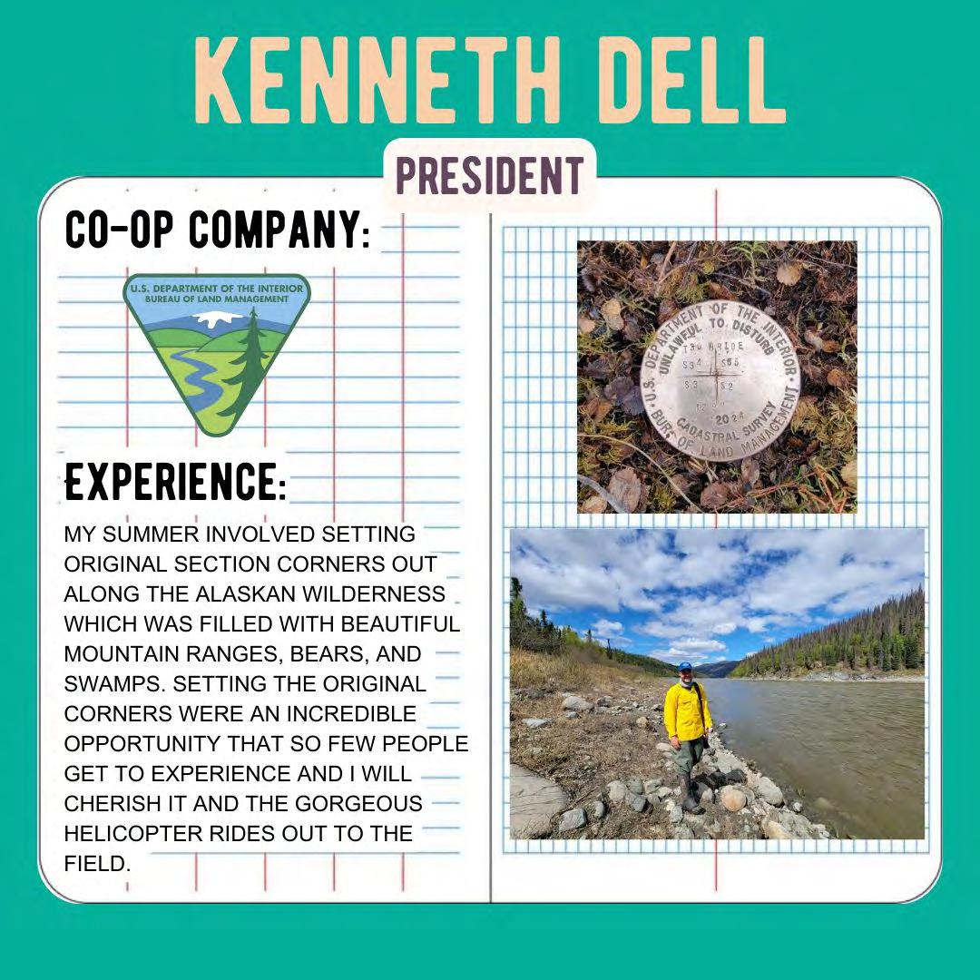
Excerpt from “1884 - The Public Domain, Its History with Statistics, Public Land Commission,” Thomas Donaldson (2017) US Government Treaties and Reports.
THE PURCHASE OF THE EAST AND WEST FLORIDAS FROM SPAIN.
PRELIMINARY WORK AND NEGOTIATIONS.
Spain, by the discovery of Florida on Palm Sunday, March 27, 1512, and its occupa tion dating from the landing of Ponce de Leon near Saint Augustine, April 8, 1512, and the various expeditions following, including that of Fernando de Soto, in 1536, who ex plored its interior, acquired the right to the possession of the Territory of Florida. Sir Francis Drake's capture of Saint Augustine, in 1586, was temporary. In 1736, Spain ceded Florida to Great Britain, in exchange for the island of Cuba, and the British flag was raised over it. In 1783, after the conclusion of the definitive treaty of peace between Great Britain and the United States, Great Britain ceded to Spain the prov inces of East and West Florida, and they again came under the flag of Spain. This cession gave no definition of boundaries, and the province of West Florida became a subject of dispute between the United States and Spain.
THE PERDIDO CLAIM.
Great Britain held that the thirty-first parallel of north latitude was the northern boundary of the province she ceded, extending from the Appalachicola to the Mississippi River, and by another treaty made at the same time stated that the territory to the north of that parallel belonged to the United States (now in Alabama and Mississippi). The United States thereupon iusisted upon the boundary at the thirty- first parallel north latitude. Spain claimed that the province of West Florida as ceded by Great Britain to her, remained as it was declared to be by the proclamation of the King of Great Britain, of date October 7, 1763, and extended by the recommendation of the British Board of Trade, June 6, 1764, and so held and governed by the British Government as shown by communications to Governor Elliott, of May 15, 1767. This included the territory between the rivers that bounded the original province and between the thirty-first parallel north latitude (going north) and to that of a line east and west from the mouth of the Yazoo River. Spain at once took possession of this territory and held it for a time, but by the treaty of 1795, October 27, waived claims to the territory north of latitude 31°
north. This left the remainder of the province of West Florida still in doubt—that portion between the Iberville and Perdido rivers, and south of latitude 31° north, the national boundary. The United States claimed this country under the following title: October 1, 1800, Spain ceded to France the province of Louisiana. France, by the treaty of Paris, sold the same to the United States, April 30, 1803. Spain claimed after 1803, and up to 1819 (date of her sale of Florida to the United States) that the cession to France was only for the city and island of New Orleans and the province of Louisiana west of the Mississippi River, which she had in 1762 received from France. Part of this Perdido claim was afterwards annexed below 31° north latitude to the States of Alabama and Mississippi, extending thence to the Gulf. The United States by joint resolution of Congress, January 15, 1811, and acts of like date and of March 3, 1811, passed in secret session, made public in 1817, occu pied and held this disputed territory for a time. Spain and France protested, but the United States never withdrew its claim to the territory.
The cession of the province of Louisiana by France in 1803 gave the United States a title to the territory west of the Perdido. This was also occupied.
Before and after the purchase of Louisiana, Mr. Jefferson looked toward the purchase of the province of Florida from Spain, and after the decision of Congress he appointed Mr. Armstrong, of New York, and Mr. Bowdoin, of Massachusetts, to negotiate the purchase of Florida from Spain. This negotiation failed. Then Mr. Monroe was called upon to join Mr. Pinckney, minister at Madrid, in the settlement of our difficulties with Spain both as to boundaries and claims for commercial spoliations. Mr. Monroe, in a letter to M. Talleyrand at Paris, November 4, 1804, gives a full statement of this, as well as did Mr. Livingston, in a letter of date November 12, 1804, at Paris, to M. Talley rand, wherein he states “that Mr. Monroe, minister plenipotentiary from the United States to the court of London, is now here, on his way to Spain, where he is specially charged, in conjunction with Mr. Pinckney, to negotiate for the purchase of Florida.” These letters asked the favorable intervention of the Emperor Napoleon with the Spanish King in the matter of the purchase. Talleyrand in his answer intimated that Bonaparte nonconcurred in the American view of the boundary question.
January 28, 1805, Messrs. Monroe and Pinckney addressed a letter to Don Pedro Cevallos, inclosing a project of a convention between the countries. This was answered by Don Cevallos January 31, 1805. A correspondence running until
the 15th of May then followed, and ended in a refusal on the part of the King to treat further and in a rejection of the proffer of adjustment or purchase. On May 22, 1805, Mr. Monroe took leave of the King.
In 1807 Spain issued a decree similar to the French decree of November 21, 1806. This intensified public feeling aided by the fact that the question of settlement of national boundaries (Louisiana) and spoliation claims had not been settled between the two countries. A new Spanish minister, Don Onis, in 1808, arrived in behalf of the supporters of the royal family who had rebelled against Bonaparte's rule in Spain. President Jefferson declined to receive him.
In 1810, in the province of West Florida, and in that part lying on the Mississippi River, disturbances took place and the authority of Spain was defied. The fort at Baton Rouge was seized. The citizens declared themselves independent, adopted a flag, and made proclamation of the fact.
October 27, 1810, President Madison issued proclamation taking possession of the east bank of the Mississippi under the treaty of 1803, claiming that occupation was neces sary to protect both the United States and Spain from violence, and would leave the question of ownership for the future. Governor Claiborne, of Orleans Territory, was dispatched at once from Washington to take possession. An attack upon Mobile by a party from near Fort Stoddart failed. They threatened another attack, whereupon Folck, the Spanish governor, in a letter to the American authorities hinted at a prob ability of his desiring to treat with them for the transfer of the province, unless he was re-enforced from Havana or Vera Cruz.
This occupation met strong opposition in the United States. An expedition was organized and acted against the Seminole Indians in East Florida. The legislature of Georgia, November 20, 1812, resolved that the occupation of Florida was essential to the safety of the State, and passed an act to raise a State force to act against Saint Augustine and punish the Indians. Ear1y in 1813 a volunteer force entered Florida. Orders were issued July 14, 1814, by the War Department, to Andrew Jackson commanding, to take possession of the town of Pensacola, as Florida at this time had become a place of organization for marauding bands to act against the United States. The orders were six months reaching him. In the mean time a British naval force arrived at Pensacola and landed some troops under Colonel Nichols, who at once began to arm and equip the Creek refugees, enemies
of the United States. The orders to General Jackson were countermanded October 21, 1814, but he, in the mean time, had entered Pensacola, driven out the British, and delivered the place to the Spanish authorities. Congressional inquiries were made this year of the executive department as to the position of the United States in relation to Spain. The answer was that it was friendly.
In 1815 Don Onis, the Spanish ambassador, was recognized. In 1816 the Spanish minister at Washington remonstrated against the continued occupation by the United States of West Florida and insisted on non-intercourse between the United States and Mexico, that province being then in revolt against Spain. Mr. Monroe, Secretary of State for President Madison, suggested that as West Florida was now separated from the Spanish possessions of Mexico, it was of but little advantage to Spain to hold it, and an exchange of part of Louisiana bordering on Texas was suggested for Florida, and neutrality as to Mexico was intimated; but nothing definite resulted from this correspondence.
In 1817, Mr. Monroe now being President, it was proposed to receive from Spain in settlement of the claims held by citizens of the United States against her, the cession of the province of Florida. This embraced the offer to accept for a western boundary of Louisiana the river Colorado, of Texas. To this Don Onis, the Spanish minister, objected.
A correspondence now ensued, from July 4, 1817, to March 18, 1818, between John Quincy Adams, Secretary of State, and Don Luis de Onis, which explains fully the differences between the two nations and their respective claims as to boundaries. (See American State Papers, vol. 12, pp. 1 to 195.)
During 1817, the Seminoles residing on Spanish territory harbored a large number of refugee Creeks of the late war. They were a constant source of alarm and war to the Georgia settlers. The Indians, in retaliation for their expulsion from the just ceded Creek territory, north of the line of Florida, attacked and captured a boat on the Appalachicola River. General Jackson was ordered to take command in person of the United States forces in the South, and orders were issued to pursue the Indians into Florida if necessary. In 1818, the statement of President Monroe, in his message to Congress, that expeditions had been authorized against Amelia Island and Galveston, was met with a protest from Don Luis de Onis, the Spanish minister at Washington. March 14, 1818, President Monroe transmitted to
Congress the correspondence between John Quincy Adams and Don Luis de Onis, above referred to.
In April, 1818, General Jackson had, in the prosecution of the Indian (Seminole) war, taken possession of the Spanish fort at St. Mark's, Florida, taking it with force but without bloodshed, and thus Florida was occupied by troops of the United States. On May 24, 1818, General Jackson, on a rumor of the encouragement of an Indian invasion of Alabama (having the day before received a protest from the Spanish governor against the invasion, and a promise of resistance), entered the city of Pensacola. The governor held the fort at the Barrancas. An assault was ordered against it, when it capitulated on the 27th of May. On June 17, the Spanish minister protested to the United States against General Jackson's acts while a treaty was under consideration. The unfulfilled treaty agreements of Spain to restrain Indians in her territory from raiding the United States was set up, and the aid and assistance rendered the Indians by the forts at St. Mark's and Pensacola was held to be sufficient ground for their seizure, and that now that the Indian war was over, the two forts would be surrendered to Spain, when Spain would agree to garrison them with a force large enough to control the Indians.
The ratification of the convention of 1802, (now October, 1818,) arrived from Spain.
NEGOTIATIONS OPENED FOR CESSION, 1818.
De Onis opened negotiations under the instructions he had received with the rati fication of the convention of 1802. He asked conditions, and that the boundary of the territory of Spain west of the Mississippi should be due north of a line commencing on the Gulf of Mexico east of the river Sabine, and extending to the Missouri, and thence to its source. Secretary Adams offered in reply, October 31, 1818, as his ulti matum, to accept as a boundary for the Spanish possessions west of the Mississippi (which would be the western and the southern boundary of the Louisiana province purchased from France in 1803) the river Sabine to the thirtythird degree north latitude, thence to the Red River due north, that river to its source, the crest of the Rocky Mountains to the forty-first degree north latitude, and a line thence due west to the Pacific Ocean, about the present boundary of the Louisiana purchase. This claim Don Onis (November 16) pronounced unheard
of, and proffered in lien an agree ment to the line of the Sabine River, with a line due north to the Missouri, and from and along that river to its head. Here the negotiations rested for a time, pending instructions from Spain. In the Congress of 1819, in January, a fierce debate came on as to the right of invasion of Spanish soil in Florida. February 22, 1819, John Quincy Adams, on behalf of the United States, and Don Luis de Onis, on behalf of Spain, at Washington, signed the treaty of the cession of Florida to the United States, as follows:
Treaty of amity, settlement, and limits between the United States of America and his catholic majesty. Concluded February 22, 1819; ratifications exchanged February 22, 1821; proclaimed February 22, 1821. Also ratification of the same by the King of Spain, October 24, 1820.
The United States of America and his catholic majesty, desiring to consolidate, on a, permanent basis, the friendship and good correspondence which happily prevails be tween the two parties, have determined to settle and terminate all their differences and pretensions, by a treaty, which shall designate, with precision, the limits of their respective bordering territories in North America.
With this intention the President of the United States has furnished with their full powers John Quincy Adams, Secretary of State, of the said United States; and his catholic majesty has appointed the Most Excellent Lord Don Luis De Onis, Gonzalez, Lopez y Vara, Lord of the town of Rayaces, Perpetual Regidor of the Corporation of the city of Salamanca, Knight Grand Cross of the Royal American Order of Isabella the Catholic, decorated with the Lys of La Vendée, Knight Pensioner of the Royal and Distinguished Spanish Order of Charles the Third, Member of the Supreme As sembly of the said Royal Order; of the Council of his catholic majesty; his secre tary, with exercise of decrees, and his envoy extraordinary and minister plenipotentiary near the United States of America;
And the said plenipotentiaries, after having exchanged their powers, have agreed upon and concluded the following articles:
ART. I. There shall be a firm and inviolable peace and sincere friendship between the United States and their citizens and his catholic majesty, his successors and subjects, without exception of persons or places.
ART. II. His catholic majesty cedes to the United States, in full property and sov ereignty, all the territories which belong to him, situated to the eastward of the Mississippi, known by the name of East and West Florida. The adjacent islands dependent on said provinces, all public lots and squares, vacant lands, public edifices, fortifica tions, barracks, and other buildings, which are not
private property, archives and documents, which relate directly to the property and sovereignty of said provinces, are in cluded in this article. The said archives and documents shall be left in possession of the commissaries or officers of the United States, duly authorized to receive them.
ART. III. The boundary line between the two countries, west of the Mississippi, shall begin on the Gulph of Mexico, at the month of the river Sabine, in the sea, continuing north, along the western bank of that river, to the 32d degree of latitude; thence, by a line due north, to the degree of latitude where it strikes the Rio Roxo of Natchi toches, or Red River; then following the coarse of the Rio Roxo westward, to the de gree of longitude 100 west from London and 23 from Washington; then, crossing the said Red River, and running thence, by a line due north, to the river Arkansas; thence, following the course of the southern bank of the Arkansas, to its source, in latitude 42 north; and thence, by that parallel of latitude, to the South Sea. The whole as being laid down in Melish's map of the United States, published at Philadelphia, improved to the first of January, 1818. But if the source of the Arkansas River shall be found to fall north or south of latitude 42, then the line shall run from the said source due south or north, as the case may be, till it meets the said parallel of latitude 42, and thence, along the said parallel, to the South Sea: All the islands in the Sabine, and the said Red and Arkansas rivers, throughout the course thus described, to belong to the United States; but the use of the waters, and the navigation of the Sabine to the sea, and of the said rivers Roxo and Arkansas, throughout the extent of the said boundary, on their respective banks, shall be common to the respective inhabitants of both nations.
The two high contracting parties agree to cede and renounce all their rights, claims, and pretensions, to the territories described by the said line, that is to say: The United States hereby cede to his catholic majesty, and renounce forever, all their rights, claims, and pretensions, to the territories lying west and south of the above described line; and, in like manner, his catholic majesty cedes to the said United States all his rights, claims, and pretensions to any territories east and north of the said line, and for himself, his heirs, and successors, renounces all claim to the said territories forever.
ART. IV. To fix this line with more precision, and to place the landmarks which shall designate exactly the limits of both nations, each of the contracting parties shall ap point a commissioner and a surveyor, who shall meet before the termination of one year from the date of the ratification of this treaty at Natchitoches, on the Red River, and proceed to run and mark the said line, from the mouth of the Sabine to the Red River, and from the Red River to the river Arkansas, and to ascertain the latitude of the source of the said river Arkansas, in conformity to what is above agreed upon and stipulated, and the line of latitude 42, to the South Sea: they shall make out
plans, and keep journals of their proceedings, and the result agreed upon by them shall be considered as part of this treaty, and shall have the same force as if it were inserted therein. The two governments will amicably agree respecting the necessary articles to be furnished to those persons, and also as to their respective escorts, should such be deemed necessary.
ART. V. The inhabitants of the ceded territories shall be secured in the free exercise of their religion, without any restriction; and all those who may desire to remove to the Spanish dominions shall be permitted to sell or export their effects, at any time whatever, without being subject, in either case, to duties.
ART. VI. The inhabitants of the territories which his catholic majesty cedes to the United States, by this treaty, shall be incorporated in the Union of the United States, as soon as may be consistent with the principles of the Federal Constitution, and ad mitted to the enjoyment of all the privileges, rights, and immunities of the citizens of the United States.
ART. VII. The officers and troops of his catholic majesty, in the territories hereby ceded by him to the United States, shall be withdrawn, and possession of the places occupied by them shall be given within six months after the exchange of the ratifications of this treaty, or sooner if possible, by the officers of his catholic majesty to the commis sioners or officers of the United States duly appointed to receive them; and the United States shall furnish the transports and escort necessary to convey the Spanish officers and troops and their baggage to the Havana.
ART. VIII. All the grants of land made before the 24th of January, 1818, by his catholic majesty, or by his lawful authorities, in the said territories ceded by his majesty to the United States, shall be ratified and confirmed to the persons in possession of the lands, to the same extent that the same grants would be valid if the territories had remained un der the dominion of his catholic majesty. But the owners in possession of such lands, who, by reason of the recent circumstances of the Spanish nation, and the revolutions in Europe, have been prevented from fulfilling all the conditions of their grants, shall complete them within the terms limited in the same, respectively, from the date of this treaty; in default of which the said grants shall be null and void. All grants made since the said 24th of January, 1818, when the first proposal, on the part of his catholic majesty, for the cession of the Floridas was made, are hereby declared and agreed to be null and void.
ART. IX. The two high contracting parties, animated with the most earnest desire of conciliation, and with the object of putting an end to all the differences which have ex isted between them, and of confirming the good understanding which they wish to be forever maintained between them, reciprocally renounce all claims for damages or injuries which they, themselves, as well as their respective citizens and subjects, may have suffered until the time of signing this treaty.
The renunciation of the United States will extend to all the injuries mentioned in the convention of the 11th of August, 1802.
2. To all claims on account of prizes made by French privateers, and condemned by French consuls, within the territory and jurisdiction of Spain.
3. To all claims of indemnities on account of the suspension of the right to deposit at New Orleans in 1802.
4. To all claims of citizens of the United States upon the government of Spain, arising from the unlawful seizures at sea, and in the ports and territories of Spain, or the Spanish colonies.
5. To all claims of citizens of the United States upon the Spanish Government, state ments of which, soliciting the interposition of the Government of the United States, have been presented to the Department of State, or to the minister of the United States in Spain, since the date of the convention of 1802, and until the signature of this treaty.
The renunciation of his catholic majesty extends—
1. To all the injuries mentioned in the convention of the 11th of August, 1802.
2. To the sums which his catholic majesty advanced for the return of Captain Pike from the Provincias Internas.
3. To all injuries caused by the expedition of Miranda, that was fitted out and equipped at New York.
4. To all claims of Spanish subjects upon the Government of the United States arising from unlawful seizures at sea, or within the ports and territorial jurisdiction of the United States.
Finally, to all the claims of subjects of his catholic majesty upon the Government of the United States in which the interposition of his catholic majesty's government has been solicited, before the date of this treaty and since the date of the convention of 1802, or which may have been made to the department of foreign affairs of His Majesty, or to his minister in the United States.
And the high contracting parties, respectively, renounce all claim to indemnities for any of the recent events or transactions of their respective commanders and officers in the Floridas.
The United States will cause satisfaction to be made for the injuries, if any, which, by process of law, shall be established to have been suffered by the Spanish officers, and individual Spanish inhabitants, by the late operations of the American army in Florida.
ART. X. The convention entered into between the two governments, on the 11th of August, 1802, the ratifications of which were exchanged the 21st of December, 1818, is annulled.
ART. XI. The United States, exonerating Spain from all demands in future, on account of the claims of their citizens to which the renunciations herein contained extend, and considering them entirely cancelled, undertake to make satisfaction for the same, to an amount not exceeding five millions
of dollars. To ascertain the full amount and validity of those claims, a commission, to consist of three commissioners, citizens of the United States, shall be appointed by the President, by and with the advice and consent of the Senate, which commission shall meet at the city of Washington, and, within the space of three years from the time of their first meeting, shall receive, examine, and decide upon the amount and validity of all the claims included within the descriptions above mentioned. The said commissioners shall take an oath or affirmation, to be entered on the record of their proceedings) for the faithful and diligent discharge of their duties; and, in case of the death, sickness, or necessary absence of any such commissioner, his place may he supplied by the appointment, as aforesaid, or by the President of the United States, during the recess of the Senate, of another commissioner in his stead. The said commissioners shall be authorized to hear and examine, on oath, every question relative to the said claims, and to receive all suitable authentic testi mony concerning the same. And the Spanish Government shall furnish all such documents and elucidations as may be in their possession, for the adjustment of the said claims, according to the principles of justice, the laws of nations, and the stipulations of the treaty between the two parties of 27th October, 1795; the said documents to be specified, when demanded, at the instance of the said commissioners.
The payment of such claims as may be admitted and adjusted by the said commissioners, or the major part of them, to an amount not exceeding five millions of dollars, shall be made by the United States, either immediately at their Treasury, or by the creation of stock, bearing an interest of six per cent, per annum, payable from the proceeds of sales of public lands within the territories hereby ceded to the United States, or in such other manner as the Congress of the United States may prescribe by law.
The records of the proceedings of the said commissioners, together with the vouchers and documents produced before them, relative to the claims to be adjusted and decided upon by them, shall, after the close of their transactions, be deposited in the Department of State of the United States; and copies of them, or any part of them, shall be furnished to the Spanish Government, if required, at the demand of the Spanish min ister in the United States.
ART. XII. The treaty of limits and navigation, of 1795, remains confirmed in all and each one of its articles excepting the 2, 3, 4, 21, and the second clause of the 22d arti cle, which, having been altered by this treaty, or having received their entire execution, are no longer valid.
With respect to the 15th article of the same treaty of friendship, limits, and naviga tion of 1795, in which it is stipulated that the flag shall cover the property, the two high contracting parties agree that this shall be so understood with respect to those powers, who recognize this principle; but if either of the two contracting parties shall be at war with a third party, and
the other neutral, the flag of the neutral shall cover the property of enemies whose government acknowledge this principle, and not of others.
ART. XIII. Both contracting parties, wishing to favour their mutual commerce, by affording in their ports every necessary assistance to their respective merchant vessels, have agreed that the sailors who shall desert from their vessels in the ports of the other, shall be arrested and delivered up, at the instance of the consul, who shall prove, never theless, that the deserters belonged to the vessels that claimed them, exhibiting the document that is customary in their nation: that is to say, the American consul in a Spanish port shall exhibit the document known by the name of articles, and the Spanish consul in American ports the roll of the vessel; and if the name of the deserter or deserters who are claimed shall appear in the one or the other, they shall be arrested, held in custody, and delivered to the vessel to which they shall belong.
ART. XIV. The United States hereby certify that they have not received any compensation from France for the injuries they suffered from her privateers, consuls, and tribunals on the coasts and in the ports of Spain, for the satisfaction of which provision is made by this treaty; and they will present an authentic statement of the prizes made, and of their true value, that Spain may avail herself of the same in such manner as she may deem just and proper.
ART. XV. The United States, to give to his catholic majesty a proof of their desire to cement the relations of amity subsisting between the two nations, and to favour the commerce of the subjects of his catholic majesty, agree that Spanish vessels, coming laden only with productions of Spanish growth or manufactures, directly from the ports of Spain, or of her colonies, shall be admitted, for the term of twelve years, to the ports of Pensacola and St. Augustine, in the Floridas, without paying other or higher duties on their cargoes, or of tonnage, than will be paid by the vessels of the United States. During the said term no other nation shall enjoy the same privileges within the ceded territories. The twelve years shall commence three months after the exchange of the ratifications of this treaty.
ART. XVI. The present treaty shall be ratified in due form, by the contracting parties, and the ratifications shall be exchanged in six months from this time, or sooner if possible.
In witness whereof we, the underwritten plenipotentiaries of the United States of America and of his catholic majesty, have signed, by virtue of our powers, the present treaty of amity, settlement, and limits, and have thereunto affixed our seals, respectively.
Done at Washington this twenty-second day of February, one thousand eight hundred and nineteen.
JOHN QUINCY ADAMS. [ L. S. ] LUIS DE ONIS. [ L.S. ]
POLITICAL ACTION ON THE TREATY.
This treaty was unanimously ratified by the Senate of the United States. Spain did not ratify at once, but let the time fixed for ratification expire. Congress, in expecta tion of an immediate ratification by Spain, passed an act authorizing the President to take possession of the Floridas.
The hesitation of Spain to ratify was the cause of vigorous and urgent diplomatic action. De Onis was recalled as Spanish ambassador, and Don Vives sent out. He came by the way of Paris and London. On his arrival at Washington he opened a corre spondence with Mr. Adams, who demanded action upon the treaty already entered into between the United States and Spain, upon full powers and in conformity to instruc tions. A stormy political discussion took place in Congress pending ratification by Spain. Much was made of the proposed western boundary of Louisiana.
RATIFICATION BY THE KING OF SPAIN.
October 29, 1820, the treaty was ratified by the King of Spain.
Ratification* by His Catholic Majesty, on the twenty-fourth day of October, in the year of our Lord one thousand eight hundred and twenty.
Ferdinand the Seventh, by the Grace of God and by the constitution of the Spanish monarchy, King of the Spains.
Whereas on the twenty-second day of February, of the year one thousand eight hundred and nineteen last past, a treaty was concluded and signed in the city of Wash ington, between Don Luis de Onis, my envoy extraordinary and minister plenipotentiary, and John Quincy Adams, Esq., Secretary of State of the United States of America, competently authorized by both parties, consisting of sixteen articles, which had for their object the arrangement of differences and of limits between both gov ernments and their respective territories, which are of the following form and literal tenor: [Here follows the above treaty, word for word.]
Therefore, having seen and examined the sixteen articles aforesaid, and having first obtained the consent and authority of the General Cortes of the nation with respect to the cession mentioned and stipulated in the 2d and 3d articles, I approve and ratify all and every one of the articles referred to, and the clauses which are contained in them; and, in virtue of these presents,
I approve and ratify them; promising on the faith and word of a King, to execute and observe them, and to cause them to be executed and observed entirely as if I myself had signed them; and that the circumstance of having exceeded the term of six months, fixed for the exchange of the ratifications in the 16th article, may afford no obstacle in any manner, it is my deliberate will that the present ratification he as valid and firm, and produce the same effects, as if it had been done within the determined period. Desirous at the same time of avoiding any doubt or ambiguity concerning the meaning of the 8th article of the said treaty, in respect to the date which is pointed out in it as the period for the confirmation of the grants of lands in the Floridas, made by me, or by the competent authorities in my royal name, which point of date was fixed in the positive understanding of the three grants of land made in favor of the Duke of Alagon, the Count of Punonrostro, and Don Pedro de Vargas, being annulled by its tenor, I think proper to declare that the said three grants have remained and do remain entirely annulled and invalid; and that neither the three individuals mentioned, nor those who may have title or interest through them, can avail themselves of the said grants at any time, or in any manner; under which explicit declaration the said 8th article is to be understood as ratified. In the faith of all which I have commanded to despatch these presents. Signed by my hand, sealed with my secret seal, and counter signed by the underwritten my Secretary of Despatch of State.
Given at Madrid, the twenty-fourth of October, one thousand eight hundred and twenty.
FERNANDO.
Evaristo Perez de Castro.
[Copies of the grants annulled by the foregoing treaty will be found in 8 Statutes at Large, page 267, et seq.]
The treaty was again sent to the Senate of the United States for ratification, and ratified February 19, 1821, there being but four dissenting votes.
PROCLAMATION OF TREATY.
February 22d, 1821, two years after the signing by the agents of the respective governments, President Monroe issued the following proclamation:
By the President of the United States: a Proclamation
Whereas, a treaty of amity, settlement, and limits between the United States of America and His Catholic Majesty was concluded and signed
between their plenipo tentiaries in this city, on the twenty-second day of February, in the year of our Lord one thousand eight hundred and nineteen, which treaty, word for word, is as follows :
[Here follows the treaty in full.]
And whereas, his said Catholic Majesty did, on the twenty-fourth day of October, in the year of our Lord one thousand eight hundred and twenty, ratify and confirm the said treaty, which ratification is in the words and of the tenor following:
[Here follows the ratification by the King of Spain in full.]
And whereas, the Senate of the United States did, on the nineteenth day of the present month, advise and consent to the ratification, on the part of these United States, of the said treaty, in the following words:
"In Senate of the United States , February 19, 1821.
“Resolved, two-thirds of the Senators present concurring therein , That the Senate, having examined the treaty of amity, settlement, and limits between the United States of America and His Catholic Majesty, made and concluded on the twenty-second of February, one-thousand eight hundred and nineteen, and seen and considered the ratification thereof made by his said Catholic Majesty on the twenty-fourth day of October, one thousand eight hundred and twenty, do consent to and advise the President of the United States to ratify the same.”
And whereas, in pursuance of the said advice and consent of the Senate of the United States, I have ratified and confirmed the said treaty, in the words following, viz.:
“Now, therefore, I, James Monroe, President of the United States of America, having seen and considered the treaty above recited, together with the ratification of His Catholic Majesty thereof, do, in pursuance of the aforesaid advice and consent of the Senate of the United States, by these presents, accept, ratify, and confirm, the said treaty, and every clause and article thereof, as the same are herein before set forth.
“In faith whereof I have caused the seal of the United States of America to be hereto affixed.
“Given under my hand, at the city of Washington, this twenty-second day of February, in the year of our Lord one thousand eight hundred and twentyone, and of the Independence of the said States the forty-fifth.
“By the President: “JAMES MONROE. “ John Quincy Adams , “ Secretary of State .”
And whereas the said ratifications, on the part of the United States, and
of His Cath olic Majesty, have been this day duly exchanged, at Washington, by John Quincy Adams, Secretary of State of the United States, and by General Dn. Francisco Dionisio Vives, envoy extraordinary and minister plenipotentiary of His Catholic Majesty: Now, therefore, to the end that the said treaty may be observed and performed with good faith, on the part of the United States, I have caused the premises to be made public; and I do hereby enjoin and require all persons bearing office, civil or military, within the United States, and all others, citizens or inhabitants thereof, or being within the same, faithfully to observe and fulfil the said treaty, and every clause and article thereof.
In testimony whereof, I have caused the seal of the United States to be affixed to these presents, and signed the same with my hand.
Done at the city of Washington, the twenty-second day of February, in the year of our Lord one thousand eight hundred and twenty-one, and of the sovereignty and Independence of the United States the forty-fifth.
[ l.s] JAMES MONROE. By the President:
John Quincy Adams , Secretary of State .
THE SEVERAL ACTS AND DEEDS ACQUIRING POSSESSION OF THE FLORIDAS.
Col. Robert Butler was appointed commissioner under the treaty on the part of the United States, and Don José Coppinger on the part of Spain, for East Florida.
March 3, 1821, Congress authorized, by law, the President to organize a temporary government for Florida pending legislation.
President Monroe, March 10, 1821, appointed Major-General Andrew Jackson governor, his commission vesting in him all the powers and duties heretofore held and exercised by the captain-general, intendant, and governor under Spain.
SURRENDER OF THE FLORIDAS BY SPAIN.
July 10, 1821, Don José Coppinger, appointed a commissioner by the captaingeneral of Cuba, and Col. Robert Butler, appointed a commissioner on the part of the United States, met at Saint Augustine and, after inventory, proceeded to turn over for Spain and receive for the United States the province of East Florida.
Copy of the paper in the English language, signed by the commissioner on the part
of the United States, and the commissioner on the part of His Catholic Majesty, upon the delivery of possession of the province of East Florida to the United States.
In the place of St. Augustine, and on the 10th day of July, eighteen hundred and twenty-one, Don José Coppinger, colonel of the national armies, and commissioner, ap pointed by his excellency the captain-general of the island of Cuba, to make a formal delivery of this said place and province of East Florida to the Government of the United States of America, by virtue of the treaty of cession concluded at Washington on the 22d of February, 1819, and the royal schedule of delivery of the 24th of October, of the last year, annexed to the documents mentioned in the certificate that form a heading to these instruments in testimony thereof, and the adjutant-general of the southern division of said States, Colonel Don Robert Butler, duly authorized by the aforesaid Government to receive the same; we having had several conferences in order to carry into effect our respective commissions, as will appear by our official communications, and having re ceived by the latter, the documents, inventories, and plans, appertaining to the prop erty and sovereignty of the Spanish nation held in this province and its adjacent islands depending thereon, with the sites, public squares, vacant lands, public edifices, fortifications, and other works, not being private property, and the same having been preceded by the arrangements and formalities that, for the greater solemnity of this important act, they have judged proper, there has been verified, at four o'clock of the evening of this day, the complete and personal delivery of the fortifications, and all else of this aforesaid province to the commissioner, officers, and troops of the United States; and, in consequence thereof, having embarked for the Havana the military and civil officers and Spanish troops, in the American transports provided for this purpose, the Spanish authorities having this moment ceased the exercise of their functions, and those appointed by the American Government having began theirs; duly noting that we have transmitted to our governments the doubts occurring whether the artillery ought to be comprehended in the fortifications, and if the public archives, relating to private property, ought to remain and be delivered to the American Government by virtue of the cession, and that there remains in the fortifications, until the aforesaid resolution is made, the artillery, munitions, and implements, specified in a particular inventory, awaiting on these points, and the others appearing in question in our correspondence, the superior decision of our respective governments, and which is to have, whatever may be the result, the most religious compliance at any time that it may arrive, and in which the possession that at present appears given shall not serve as an obstacle. In testimony of which, and that this may at all times serve as an expressive
and formal receipt in this act, we, the subscribing commissioners, sign four instruments of this same tenor, in the English and Spanish languages, at the above-mentioned place, and said day, month, and year.
ROBERT BUTLER. JOSÈ COPPINGER.
[To the original act there is a certificate in the Spanish language, of which the following is a translation:]
In faith whereof I certify that the preceding act was executed in the presence of the illustrious Ayuntamiento, and various private persons assembled, and also of various military and naval officers of the Government of the United States of America.
JUAN DE ENTRALGO.
Notary of the Government and Secretary of the Cabildo.
St. Augustine , 10 th July , 1821.
TRANSFER OF THE PROVINCE OF WEST FLORIDA.
The Province of West Florida was transferred to the United States July 17, 1821. It was received by General Jackson, commissioner on behalf of the United States, from José Callava, commissioner on behalf of Spain, at Pensacola.
Copy of the paper in the English language signed by the commissioner on the part of the United States, and the commissioned on the part of his catholic majesty, upon the delivery of possession of the province of West Florida to the United States.
The undersigned, Major General Andrew Jackson, of the State of Tennessee, commissioner of the United States, in pursuance of the full powers received by him from James Monroe, President of the United States of America, of the date of the 10th of March, 1821, and of the 45th of the Independence of the United States of America, at tested by John Quincy Adams, Secretary of State, and Don José Callava, command ant of the province of West Florida, and commissioner for the delivery, in the name of his catholic majesty, of the country, territories, and dependencies, of West Florida, to the commissioner of the United States, in conformity with the powers, commission, and special mandate, received by him from the captaingeneral of the Island of Cuba, of the date of the 5th of May, 1821, imparting to him therin the royal order of the 24th of October, 1820, issued and signed
by his catholic majesty, Ferdinand the Seventh, and attested by the secretary of state, Don Evaristo Perez de Castro.
Do certify by these presents, that, on the seventeenth day of July, one thousand eight hundred and twenty-one of the Christian era, and fortysixth of the Independence of the United States, having met in the courtroom of the government house in the town of Pensacola, accompanied on either part by the chiefs and officers of the army and navy, and by a number of the citizens of the respective nations, the said Andrew Jackson, majorgeneral and commissioner, has delivered to the said Colonel Commandant Don José Callava, his before-mentioned powers; whereby he recognizes him to have received full power and authority to take possession of, and to occupy, the territories ceded by Spain to the United States by the treaty concluded at Washington on the 22d day of February, 1819, and for that purpose to repair to said territories, and there to execute and to peform all such acts and things touching the premises, as may be necessary for fulfilling his appointment conformably to the said treaty and the laws of the United States, with authority likewise to appoint any person or persons in his stead, to receive possession of any part of the said ceded territories, according to the stipulations of the said treaty: Wherefore, the Colonel Commandant Don José Cal lava immediately declared, that, in virtue and in performance of the power, commis sion, and special mandate, dated at Havana on the 5th of May, 1821, he thenceforth, and from that moment, placed the said commissioner of the United States in posses sion of the country, territories, and dependencies, of West Florida, including the fortress of St. Marks, with the adjacent islands dependent upon said province, all public lots and squares, vacant lands, public edifices, fortifications, barracks, and other buildings which are not private property, according to, and in the manner set forth by, the inventories and schedules which he has signed and delivered with the archives and documents directly relating to the property and sovereignty of the said territory of West Florida, including the fortress of St. Marks, and situated to the east of the Mississippi River, the whole in conformity with the second article of the treaty of ces sion concluded at Washington the 22d of February, 1819, between Spain and the United States, by Don Luis de Onis, minister plenipotentiary of his catholic majesty, and John Quincy Adams, Secretary of State of the United States, both provided with full powers, which treaty has been ratified on the one part by his catholic majesty, Ferdinand the Seventh, and the President of the United States, with the advice and consent of the Senate of the United States, on the other part; which ratifications have been duly exchanged at Washington the 22d of February, 1821, and the forty-fifth of the Independence of the United States of America, by General Don Dyonisius Vives, minister plenipotentiary of his catholic majesty, and John Quincy Adams, Secretary of State of the
United States, according to the instrument signed on the same day: And the present delivery of the country is made in order that, in execution of the said treaty, the sovereignty and the property of that province of West Florida, including the fortress of St. Marks, shall pass to the United States, under the stipulations therein expressed.
And the said Colonel Commandant Don José Callava has, in consequence, at this present time, made to the commissioner of the United States, Major-General Andrew Jackson, in this public cession, a delivery of the keys of the town of Pensacola, of the archives, documents, and other articles, in the inventories before mentioned; declaring that he releases from their oath of allegiance to Spain the citizens and inhabitants of West Florida who may choose to remain under the dominion of the United States.
And that this important and solemn act may be in perpetual memory, the within named have signed the same, and have sealed with their respective seals, and caused to be attested by their secretaries of commission, the day and year aforesaid.
ANDREW JACKSON.
JOSÈ CALLAVA.
By order of the Commissioner on the part Por mandato de su senoria el of the United States. Coronel Comisario del Gobierno de España.
R. K. Call , José Y. Cruzat, Sec'y of the Commission. El Secretario de la Comision.
July 17, 1821, the date of the transfer of West Florida, General Jackson at Pensa cola issued the following:
Proclamation by Major-General Andrew Jackson, governor of the Provinces of the Floridas, exercising the powers of the captain-general and of the intendant of the island of Cuba, over the said provinces, respectively.
Whereas, by the treaty concluded between the United States and Spain, on the 22d day of February, 1819, and duly ratified, the provinces of the Floridas were ceded by Spain to the United States, and the possession of the said provinces is now in the United States:
And whereas the Congress of the United States, on the 3d day of March, in the present year, did enact that, until the end of the first session of the Seventeenth Congress, unless provision for the temporary government of said provinces be sooner made by Congress, all the military, civil, and judicial powers exercised by the officers of the existing gov ernment of the said provinces, shall be, vested in such person and persons and shall be exercised in such manner as the President of the United States shall direct, for the
maintaining the inhabitants of said territories in the free enjoyment of their liberty, property, and religion; and the President of the United States has, by his commission, bearing date the tenth day of said March, invested me with all the powers, and charged me with the several duties, heretofore held and exercised by the captain-general, in-tendant, and governors, aforesaid:
I have, therefore, thought fit to issue this my proclamation, making known the prem ises, and to declare that the government heretofore exercised over the said provinces, under the authority of Spain, has ceased, and that that of the United States of America, is established over the same; that the inhabitants thereof will be incorporated in the Union of the United States as soon as may be consistent with the principles of the Federal Constitution, and admitted to the enjoyment of all the privileges, rights, and immunities of the citizens of the United States; that, in the mean time, they shall be maintained and protected in the free enjoyment of their liberty, property, and the religion they profess; that all laws and municipal regulations which were in existence at the cessation of the late government, remain in full force; and all civil officers charged with their execution, except those whose powers have been especially vested in me, and except, also, such officers as have been intrusted with the collection of the revenue, are continued in their functions, during the pleasure of the governor for the time being, or until provision shall otherwise be made.
And I do hereby exhort and enjoin all the inhabitants and other persons within the said provinces, to be faithful and true in their allegiance to the United States, and obedient to the laws and authorities of the same, under full assurance that their just rights will be under the guardianship of the United States, and will be maintained from all force and violence from without or within.
Given at Pensacola this [ tenth day of July for East Florida, and seventeenth day of July for West Florida,] one thousand eight hundred and twenty-one. ANDREW JACKSON.
By the Governor:
R. K. Call , Acting Secretary of the Floridas . St. Augustine, East Florida , July 10, 1821.
By the Governor: Robert Butler , United States Commissioner.
And thus the banner of Spain, which was first raised in Florida April 8, 1512, giving place temporarily to the English from 1736 to 1783, was on the 10th and 17th of July, 1821, after a period of about three hundred and eight years, replaced by the flag of the United States.
BOUNDARIES OF THE FLORIDAS.
General Jackson had serious difficulties thereafter with the Spanish officials in ob taining documents and papers relating to the transfer.
March 30, 1822, Congress passed an organic act for the Territory of Florida, provid ing a civil government, and thus superseding the laws of Spain, which continued in force until this action by Congress. William P. Duval was appointed governor. The treaty stipulation in regard to the western and southern boundary of the Louisiana purchase, or eastern and western boundary of the Spanish possessions (Mexico) west of the Mississippi, were not carried out with Spain because of the war between Mexico and Spain.
January 12, 1828, the United States entered into treaty with Mexico, J. R. Poinsett acting on behalf of the United States, and S. Camacho and J. Y. Esteva on the part of Mexico, at the City of Mexico. (Ratifications exchanged April 5, 1832; proclaimed April 5, 1832.) This treaty referred to the Florida treaty of 1819, and to the boundary line which was established by Spain when Mexico constituted part of that monarchy, and confirmed the third and fourth articles of the treaty of Spain with the United States of 1819. It was ratified by the Senate of the United States with only three dis senting votes. This treaty was carried out, and the boundary between the United States and Mexico fixed as follows:
The boundary line between the two countries, west of the Mississippi, shall begin on the Gulf of Mexico, at the mouth of the river Sabine, in the sea, continuing north along the western bank of that river to the thirtysecond degree of latitude; thence by a line due north to the degree of latitude where it strikes the Rio Roxo of Natchitoches, or Red River; then following the course of the Rio Roxo westward to the degree of longitude one hundred west from London and twenty-three from Washington; then crossing the said Red River, and running thence by a line due north to the river Arkansas; thence, following the course of the southern bank of the Arkansas, to its source, in latitude forty-two north; and thence, by that parallel of latitude, to the South Sea; the whole being as laid down in Melish's map of the United States, published at Philadelphia, improved to the first of January, one thousand eight hundred and eighteen. But if the source of the Arkansas River shall be found to fall north or south of latitude forty-two, then the line shall run from the said source due south or north, as the case may be, till it meets the said parallel of latitude forty-two, and thence along the said parallel to
the South Sea, all the islands in the Sabine, and the said Red and Arkansas rivers, throughout the course thus described, to belong to the United States of America; but the use of the waters and the navigation of the Sabine to the sea, and of the said rivers Roxo and Arkansas, throughout the extent of the said boundary on their respective banks, shall be common to the respective inhabitants of both na tions.
The two high contracting parties agree to cede and renounce all their rights, claims, and pretensions to the territories described by the said line; that is to say, the United States hereby cede to his catholic majesty, renounce forever, all their rights, claims, and pretensions to the territories lying west and south of the above-described line; and, in like manner, his catholic majesty cedes to the said United States all his rights, claims, and pretensions to any territories east and north of the said line; and for him self, his heirs, and successors, renounces all claim to the said territories forever.
COST AND AREA OF THE PURCHASE.
The Florida treaty cost the Government of the United States $5,000,000 in bonds similar to those issued for the Louisiana purchase, and $1,489,768 of interest on the same to the time of redemption, delivered to the Spanish Government, a total of $6,489,768, and added to the national and public domain 59,268 square miles or 37,931,520 acres, or the present State of Florida, including certain grants.
The land laws of the United States were afterward extended, as to surveys and disposition, over Florida, and the lands were disposed of thereunder, excepting certain grants made by English and Spanish authorities.
Decisions of the Supreme Court of the United States under this treaty, in relation to lands and land titles, were in the cases of Foster et al. v. Neilson (2 Peters, 306); Sou lard et al. v. The United States (4 Peters, 511); Delaware v. The United States (9 Peters, 117); Mitchel et al. v. The United States (9 Peters, 711); The United States v. Kings ley (12 Peters, 476); The United States v. Arredondo (6 Peters, 706); The United States v. Percheman (9 Peters, 51).
Authorities cited hereunder: Hildreth, History of the United States, vol. 6; Benton, Thirty Years in the United States Senate, vol. 1; “Treaties and Conventions,” State Department series, July 4, 1776-1871; American State Papers, vol. 12, Waite & Sons, 1817; Charters and Constitutions, Ben. Perley Poore, vol. 1; Reports Supreme Court of the United States, Peters, vols. 2, 4, 6, 7, 9, and 12. •
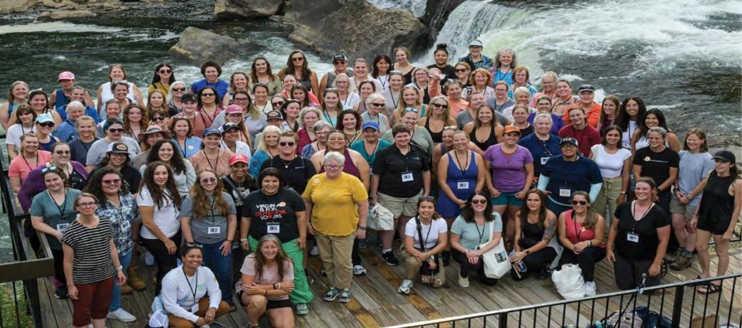
Fulfilling a Long-Time Dream at the 5th Annual Women
Surveyors
Summit 2024
Melissa Padilla Cintron, SIT 8/24/2024
At the 5th Annual Women Surveyors Summit, I had the privilege of joining an incredible group of 126 women in the field, marking my fourth time attending this empowering event.
My first experience was virtual, but this in-person gathering was especially meaningful for me.
W HY FSMS?
FSMS is a professional membership society representing the Surveying & Mapping Profession, including: Photogrammetry, Imagery, Remote Sensing, Base Mapping, GIS/LIS, Cartography, Geodesy, Geomatics, GPS, Geographic Information and Geospatial Data.
MEMBERSHIP OPPORTUNITIES
• NETWORKING
• CONTINUING EDUCATION
• LEGISLATIVE FSMPAC
• PROMOTING THE PROFESSION
• PROTECTING LICENSURE
• ADDRESSING UNLICENSED PRACTICE
• ENCOURAGING FUTURE SURVEYORS
• AWARDS & SCHOLARSHIPS
• CAREER OPPORTUNITIES
H.O. Peters Surveyor of the Year Award
Jack Breed
Jim Bennett Board Member of the Year Award
Earl Soeder
Life Member Recipient
Rick Pryce
Fellow Member Recipients
Earl Soeder & Rick Ritz
Committee Chair of the Year Award
Bon Dewitt
Young Surveyor of the Year Award
Paige Rogolino
Associate of the Year Award
Karol Hernandez
Professional Excellence Award
Justin Thomas
Perry C. McGriff Outstanding Civic Contribution Award
Brett Wood
Steven Woods Exceptional Service Award
Pam Hyatt
Chapter President of the Year Award
Brion D. Yancy
Small Chapter of the Year Award
Indian River
Large Chapter of the Year Award
Palm Beach
CHAPTER ELEVEN
Brewing Storm: Development, Water Supply, and the East Everglades
Ecological problems in Everglades National Park were getting worse fast. That was the consensus among science experts at the beginning of the 1980s. The good news was that scientific evidence increasingly pointed to poor water management as the underlying cause of most of the Everglades’ biological decline. If water deliveries to the park could be rectified, it followed, the Everglades might be saved. But scientific studies indicated that it was not enough simply to guarantee minimum quantities of water to the park. Rather, water management had to be modified so that water entering the park was distributed more nearly in the historic pattern of sheet flow. Moreover, the timing of water deliveries and duration of inundation – what was called “hydroperiod” – had to parallel the natural rainfall pattern.
Even as scientific understanding of the Everglades ecosystem improved, engineering solutions for modified water management became more difficult. Most of the sheet flow into Everglades National Park came through two broad sloughs: Shark River Slough and Taylor Slough. The entrance to both sloughs was an area bordering the east edge of the park that had remained practically uninhabited until recent years. By the early 1980s, it was lightly populated and portions were under cultivation. Initially, efforts to modify water deliveries to the park through this area focused on re-engineering options that would balance the park’s water supply requirements with the flood control needs of these area residents. By the end of the decade, those options no longer appeared realistic. In certain portions of this hotly contested area, the protection of park values was incompatible with flood control. Increasingly, water managers believed it was necessary to buy out the landowners and change the use of the land. This thinking culminated in the Everglades National Park Protection and Expansion Act of 1989.
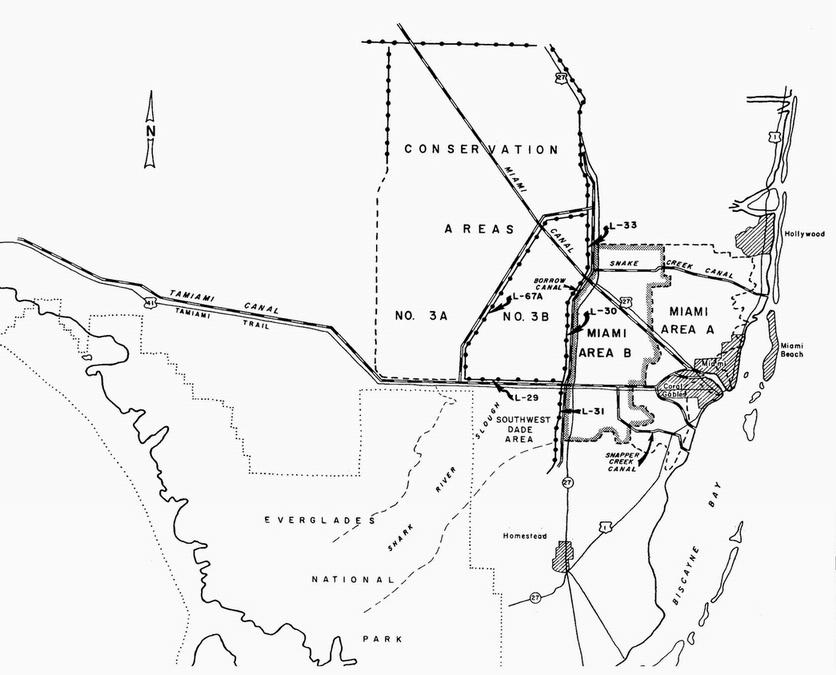
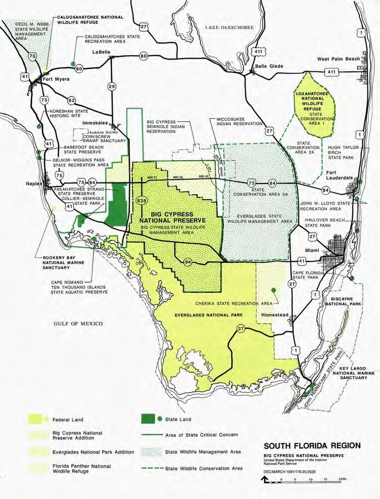
The East Everglades is the name given to an area bordering the east side of Everglades National Park. The East Everglades area in the 1980s (until a portion was added to the national park in 1989) encompassed some 153,600 acres or approximately 242 square miles.1 It included the headwaters of Shark River Slough (until 1989) and Taylor Slough. Shark River Slough, the larger slough at approximately 25 miles wide, gathers some of its waters from north of the park in Conservation Area No. 3B; that portion of the slough that runs through the East Everglades area is called Northeast Shark River Slough. Taylor Slough drains approximately 40 square miles southeast of Shark River Slough. Sawgrass marshlands predominate throughout this area, while hardwood hammocks, or tree islands, occur on higher elevations.2
In terms of hydrology and biology the area is part of the Everglades ecosystem; in terms of land use and ownership it constitutes the farthest limits of Dade County’s urban/rural interface abutting the park. Its boundaries in the 1980s were the Tamiami Canal on the north, the national park on the west and south, and Levee 31 and Canal 111 on the east. The Tamiami Canal and Levee, or L-29, it will be recalled, formed the southern edge of Conservation Area No. 3 and was completed by the Corps in 1963. L-31 was a southern extension of the eastern perimeter levee, while C-111 was at the southern end of this system and dated from the mid-1960s.3
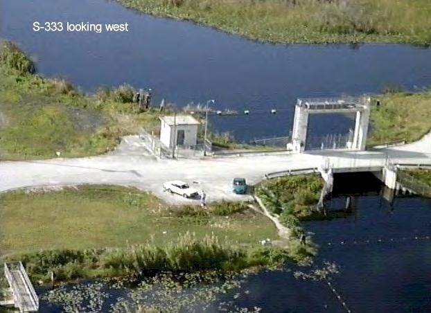
Map of the East Everglades area. [Source: Everglades National Park, "Seepage Control in Western Dade County" (1994).]
Although the land was mostly in private ownership, it remained largely uninhabited until the 1970s. Farther south, in the C-111 basin, it was still uninhabited in the 1980s, inundated by water during much of the rainy season. Early in the twentieth century the state had offered these lands for 25 cents an acre; speculators had purchased them in the 1920s and sold them as bonus property for the buying of land elsewhere. A generation passed and the worthless parcels of waterlogged property were sold and resold. The water conservation areas were created and portions of the East Everglades began to dry out. Even then, most of the area remained too wet to inhabit. Under the 1948 and 1954 congressional authorizations of C&SF Project works, the
Corps had received approval to construct L-31, running southwest from L-29, in order to provide flood and salinity protection to the area. As proposed, L-31 would consist of a northern portion (L-31N) and a western portion (L-31W); the western component would encompass a 5,000-acre area known as the Frog Pond, located at the head of Taylor Slough. Farmed as early as the 1940s, the Frog Pond had agricultural potential, but had attracted only a few vegetable growers to this point. In the 1960s, the Corps aligned the different L-31 parts, completing construction of L-31W in the early 1970s. These engineering works, combined with severe drought in 1971, exposed more ground, and by the mid-1970s the situa tion changed rapidly as people moved in to build residences and raise crops, attracted by the comparatively low price of land in this area of southwest Dade County.4
The government of Dade County was ambivalent about development of this area. In the early 1960s, the Metro-Dade County Commission supported a water control plan that would permit agricultural use during the dry season. The Southwest Dade Project received
The location of L-31 in Southwest Dade County. (Source: Jacksonville District, U.S. Army Corps of Engineers.)
congressional authorization in 1965, but after considerable planning by the Corps it was never built. County support for the project waned as the NPS began to voice opposition, fearing that the project would complicate efforts to convey water to Taylor Slough and the southeast corner of the park. County officials were even less enthusiastic about agricultural development in Southwest Dade County following the drought of 1971, which heightened concern about saltwater intrusion into the Biscayne aquifer. Nevertheless, Dade County classified nearly the entire area as agricultural in its land-use plan, and it supported construction of canals and levees north and west of the town of Homestead, which served to drain that area for crop production. It also passed zoning ordinances with stringent performance criteria that, in the minds of some residents, conveyed a public commitment to flood protection.5
The Corps, too, saw problems with development of the East Everglades. A farming practice known as “rock plowing” was particularly harmful to the environment. Farmers, when clearing the land for planting, would plow up the limestone substratum to augment the thin layer of topsoil. This limestone was very porous and acted as a filter as water percolated into the Biscayne aquifer. The Corps maintained that rock plowing was harmful to the aquifer. It discouraged the practice through its Section 404 permitting program, although by this time the Frog Pond area already bore the scars of rock plowing and the practice continued elsewhere to a limited extent.6
The Corps also required homeowners in the Ea st Everglades to apply for Section 404 permits as they were filling in wetlands to improve their home sites. The agency notified some 50 residents that they must obtain permits. After residents ignored repeated orders by the Corps to desist, the U.S. Attorney’s Office brought suit against five offenders. U.S. District Judge James W.Kehoe ruled in favor of the government, persuaded by the testimony of eight government experts that dumping in the Everglades lowlands threatened the environment. One of the defendants, Russell Carter, formed a local group in defense of property rights and posted an antigovernment sign in his yard. Another landowner threw “a pesky government bureaucrat” into a pond housing his pet alligator, while still others told the media that “if we don’t get justice through the courts we’ll get it with our guns.” Fairly or not, the homesteaders in the East Everglades were gaining a prickly reputation.7
In August 1981, Tropical Storm Dennis soaked the East Everglades with three days of torrential rain. Row crops of tomatoes and malanga disappeared under water. Avocado, lime, and mango groves were ruined. Roads around Florida City (between Homestead and the national park) remained impassable for three weeks following the storm. Farmers and homeowners angrily confronted SFWMD employees, accusing the district of deliberately ignoring their plight. Someone threw a pipe bomb into one of the canal structures on the edge of the East Everglades, though it failed to explode.8
If the county government had been dubious of this community before, it now took definite action to curtail further growth in the area, which soon became known as the 8.5 Square Mile Area. This moniker arose from the passage of a zoning ordinance on 27 October 1981 by the Board of County Commissioners stating that within the region, located in the East Everglades area west of the levees separating the park and the Miami suburbs, the county would permit only a maximum of one dwelling unit per 40 acres for re sidential use or one dwelling unit per 20 acres in conjunction with agriculture, replacing the existing one house per 5 acres regulation. The
ordinance also required notification of property purchasers and individuals seeking building permits that the county and the SFWMD had no dr ainage plan for the area. The Governing Board of the SFWMD endorsed the ordinance at a special meeting eight days prior to its enactment.9
The county aimed to slow growth in the 8.5 Square Mile Area in order to protect Miami’s water supply, but it had difficulty enforcing the ordinance. Some property owners openly defied the ordinance, building homes without permits. Others worked the system, obtaining a permit to build seasonal housing for migrant farm workers, for example, and subsequently expanding it into a second permanent dwelling, thereby getting two residential dwellings onto 40 acres. Many of the landowners were Cuban refugees who were not familiar with the permitting process. Indeed, many had already paid too much for land that had been cynically advertised as “waterfront property” and they perceived the zoning restrictions and absence of flood security as added injustices.10
Settlement of the East Everglades, and specifically of the 8.5 Square Mile Area, encroached on the national park, resulting in loss of wetlands and wildlife habitat and further interfering with the natural sheet flow of water into the park through Northeast Shark River Slough and Taylor Slough. As homesteaders in the East Everglades drained their land, it set in motion the familiar train of disturbances: marsh fires, soil subsidence, and invasion of exotic species such as Australian pine and melaleuca. To have this occurring on the park’s doorstep was especially harmful to fauna and flora. Many wildlife species used the upper sloughs within the East Everglades for nesting, feeding, foraging, and cover. It was estimated that the East Everglades had at one time provided 35 percent of South Florida’s wood stork feeding grounds, but water level manipulation rendered the area unsuitable for this species during its crucial nesting period. Development pressure also caused a reduction in incidence of 12 rare, endemic plant species, which appeared to have a detrimental effect on the biological diversity and productivity of the flora in the adjoining portion of the park.11
Park officials viewed these developments with growing concern. John M. Morehead, superintendent of Everglades National Park, welcomed the Dade County ordinance as a sign of “exceptional foresight” on the part of local officials, but it was the Corps, a sister federal agency, that held the key to improved water management in the area. In a long letter to Colonel Alfred Devereaux, Jacksonville District Engineer, in September 1982, the superintendent expressed gratitude that the Corps was studying water deliveries through the Shark River Slough and he urged the Corps to “examine ways to rejoin the historical hydrological equilibrium between the east Everglades, the Water Conservation areas, and Everglades National Park.”12
Morehead stressed the importance of Shark River Slough for wildlife habitat, and explained that loss of wetlands within the East Everglades as a result of development or hydrological change would substantially reduce wildlife populations in the park. “We believe that this condition must be reversed,” he noted. “Everglades National Park and the east Everglades are hydrologically connected and should be treated as one hydrological unit.” In other words, Morehead urged a management approach that did not stop at the park boundary. In the superintendent’s opinion, the federal interest in preserving Everglades National Park justified federal action outside the park. “There can be little doubt,” Morehead stated, “that the future of Everglades National Park is intimately tied to the future of the Shark Slough within the east
Everglades.”13 This was a bold position that reflected recent changes in NPS thinking about how to approach “external threats” to national parks.
Morehead explained that the paramount need of the park was to obtain a more natural flow of water based upon rainfall in the drainage north of the park. Currently, water deliveries were based on a minimum monthly delivery schedule established under P.L. 91-282 (1970). A new approach was required. For one thing, the 260,000 acre-feet minimum allocation for Shark River Slough was based on median flows through Tamiami Trail culverts during the period 1940-1962. It had to be recognized, Morehead wrote, that these flow data were below pre-drainage era levels since six major Everglades drainage canals were already operational by that time.14
A revised water delivery schedule must also take into account natural fluctuations in rainfall within each season, Morehead argued. The current schedule was based on average monthly flows. The resulting monthly breakdown of the schedule provided for peak flows in October and minimum flows in April and May. While the current schedule did provide for some deviations in time of drought or high water, the magnitude and timing of the deviations were determined by urban and agricultural water supply needs rather than the park’s ecological needs. Morehead wanted a schedule that would allow fluctuations “in synchrony with the natural system; a system to which the slough’s animal and plant populations have become adapted over millennia.”15
Flooded residence in the 8.5 SMA. (Source: U.S. Army Corps of Engineers, Jacksonville District.)
Morehead had been arguing these points for two years. He had written a similar letter to Colonel Devereaux’s predecessor, Colonel James W. R. Adams, in July 1980, in response to proposed changes in regulation water levels for Lake Okeechobee and the water conservation areas. The concern in the summer of 1980 was th at Everglades National Park could face a water shortage if there was a “drawdown” of water levels in these other areas. The SFWMD and the Corps were making plans to lower the water level in the conservation areas for the purpose of giving vegetation (and the deer population) a chance to rebound under drier conditions. But the park’s concerns went beyond questions of water shortage. The regulation levels tended to flatten out extreme high and low water events. While this certainly benefited agriculture and the urban populations, it harmed the park. “The trouble biologically with all such modulations is that in time the modulation reduces animal and plant diversity and favors only those few species that happen to be adapted to the modulation,” Morehead cautioned. “In an ecosystem like the Everglades marsh that isn’t particularly diverse in species to begin with, reduction in population and loss of species can happen dramatically and ra pidly.” Morehead posed a series of technical questions to Colonel Adams concerning the regulation schedules for the conservation areas. His last question was: “What modifications could be done to make the system react more fairly to systemwide rainfall?”16
The problem was deceptively complex. The C&SF Project was unique among the Corps’ flood control projects in that it covered vast areas of impounded waters moving very slowly over a nearly imperceptible gradient. From an operational standpoint it took weeks, even months, to move water from one end of the system to the other. The Corps followed a schedule of water releases for each area that was more weighted toward water supply and flood control, although other purposes such as fish and wildlife benefits were also taken into account. Maximum water levels were set according to normal rainfall patterns, meaning that when water levels rose above the maximum allowed in the regulation schedule the Corps had a responsibility to open gates and move water out of the area, if only as a hedge against flooding in case of abnormally high rainfall perhaps two or three months in the future. Colonel Adams readily admitted that the system was imprecise and subject to the caprice of nature. “We’re in a situation where science has gone about as far as it can in predicting Mother Nature but she still has the last card to play,” he told an interviewer in 1981.17 Not surprisingly, while the park superintendent focused on fluctuations in nature, the District Engineer concerned himself with weather extremes.
The winter of 1982-1983 – an El Niño event – produced the kind of freakish weather that Colonel Adams warned about. Heavy rains began in October and continued through the winter –normally Florida’s dry season – culminating in a 60-day, 20-inch deluge in January and February. The SFWMD made emergency releases from Lake Okeechobee to the St. Lucie and Caloosahatchee estuaries but that was not enough. The Corps opened the floodgates in the Tamiami Canal and levee along the northeast boundary of Everglades National Park, and from October 1982 through February 1983 the park received three-and-a-half times its minimum quota.18 In the month of February, when the minimum quota for releases through these structures was 9,000 acre-feet, the park received a whopping 88,000 acre-feet.19 While the C&SF Project afforded admirable flood protection to sugar cane fields in the EAA, winter crops in Dade County, and all the coastal cities in South Florida, the Corps succeeded only by dumping much of the excess water on the park. Ironically, at the same time that the four open gates in L29 were disgorging water into the park at the rate of approximately five billion gallons per day,
S-12C looking south into Everglades National Park. (Source: U.S. Army Corps of Engineers, Jacksonville District.)
engineers and hydrologists in the Corps and the SFWMD were beginning to consult with the park’s chief scientist, Gary Hendrix, on how to develop a rainfall-driven water delivery schedule. This was hardly the type of deviation from average monthly flows that Superintendent Morehead had in mind.
Indeed, the dumping of excess water on the park caused severe ecological damage. According to Jim Kushlan, a park wildlife biologist, the practice destroyed alligator nests and disrupted feeding patterns of the woodstork.20 Morehead agreed. “Just as soon as the birds and gators would get their nests settled, they’d get blown away by waves of water,” he related. These releases destroyed the “natural wet-and-dry rhythm” that had characterized water flow in the Everglades before drainage began, harming the lifeways of both flora and fauna.21
Insisting that floodwaters were causing grave harm to the park, Morehead and Hendrix requested an emergency meeting with the SFWMD. On 10 March 1983, Hendrix arrived alone in West Palm Beach and presented a seven-point plan to the SFWMD’s Governing Board. He began by saying that in the past few months the park had been assessing the effects of the water
delivery schedule that had been in place since 1970 and the park staff had concluded that most of the degradation to ecological values in the park had occurred from excess water in the dry season. (This was the opposite, of course, from the longstanding perception that the Everglades was dying of thirst.) Both he and the superintendent believed that without some “urgent measures” the park could not “sustain much of its resources for very long.”22
The first four points in the seven-point plan aimed at undoing the fragmentation of Conservation Area No. 3 and restoring sheet flow to the park. The plan called for filling in the L-28 canal, which ran north and south down the boundary of Conservation Area No. 3A and Big Cypress National Preserve; filling in the L-67 canal extension and removing the levee; rededicating Conservation Area No. 3B for water storage and sheet flow; and redistributing water deliveries from Conservation Area No. 3A along the whole length of the Tamiami Canal from L-28 to L-30. Collectively, these four actions would redistribute water flowing into the park from the confined area around the four floodgates in the Tamiami Canal to several historic drainages south of Big Cypress as well as the Northeast Shark River Slough. The fifth item called for a water quality monitoring program. The sixth was a request that the Corps and SFWMD defer any implementation of new drainage districts until impacts to the park were fully considered. The seventh and final point was to field test a new water delivery schedule starting as soon as possible.23
At the end of Hendrix’s presentation the Governing Board recommended that the SFWMD’s executive director, John “Jack” Maloy, report to the board in a month with a studied response. When board member Jeanne Bellamy asked Maloy for his off-the-cuff reaction, he said that he was “overwhelmed.” “Oh, you’re never overwhelmed,” Bellamy prompted. “I’ll tell you one thing,” Maloy replied. “This is a real test of whether the organization is . . . a regular bureaucratic organization or something different.” A request of this scope, Maloy explained, would normally take the organization three years just to study it. “By then the Park will be a desert,” Bellamy cut in. Maloy noted that most of the points Hendrix brought with him had been discussed already with district engineers, but this was a lot to consider all at once.24
In a letter to Marjory Stoneman Douglas and 16 other “Everglades watchers,” Nathaniel P. Reed, a member of the governing board, offered further commentary on the meeting, characterizing the Seven Point Plan as a “bombshell.” Reed seemed most surprised that Morehead, who enjoyed an exceptionally close working relationship with the board, had chosen to send a messenger instead of appearing himself. “When the District and the Park have had a problem during Morehead’s tenure, his presence, his explanation, his superb ability at negotiation have made the Board willing to find some area of cooperation,” Reed explained. After Hendrix made his proposal, Reed continued, the Corps representative, Carol White, “appeared to have apoplexy.” The emergency ploy was even a bit worrisome to Reed, who wondered if “emergency actions” were appropriate or wise. He noted that such Everglades experts as Art Marshall and Johnny Jones had “expressed sincere reservations” about implementing some of the park’s proposals without further study.25
As a former assistant secretary of the interior, Reed offered his own analysis of the park’s Seven Point Plan. “The Park’s request represents a major change in attitude,” he headlined. “The new approach may be the result of the flood conditions inundating the Park or may reflect the Superintendent’s view that as the Department of the Interior and the National Park Service
Study area of the water supply restudy. [Source: U.S. Army Corps of Engineers, Jacksonville District, Central and Southern Florida Water Supply: Reconnaissance Report (1979).]
are not actively defending the Park’s integrity [then] the local representatives must declare the present state of affairs an ‘emergency’ requiring ‘emergency’ measures.”26
Following the meeting, Maloy acted decisively. He redeployed staff to evaluate the Seven Point Plan at lightning speed, and then he called an “emergency meeting” of the Governing Board for 5 April. Defining the situation as an “emergency” gave him authority to issue an order without prior notice. He had his legal staff prepare a draft emergency order with findings of fact and conclusions of law for the Governing Board’s approval.27 At the Governing Board meeting on 5 April, Maloy duly reported on the SFWMD’s technical response to the Seven Point Plan. He recommended support for all seven measures. If the board approved, the district would approach the Corps and the NPS and ask for financial help, recognizing the federal interest in protecting the national park. Maloy presented the board with the draft emergency order, which the board adopted.28
Representatives of several environmental groups also attended the emergency meeting and expressed support for the Seven Point Plan. Peter Mott, president of the Florida Audubon Society, correctly noted that the seventh point, calling for a field test of a new water delivery schedule (and the abandonment of the present congressionally mandated one) would require an act of Congress. He predicted a “united front” on this matter in the coming year.29 Two other attendees, Michael Hevener, executive director of the Dade County Farm Bureau, and William Earl, counsel for that organization, spoke on behalf of 5,800 farmers and 7,000 farm workers of Dade County. They worried that the Seven Point Plan would cause flooding, wreck crops, and damage private property. They wanted an EIS “for any structural changes that would affect the farming interests in south Dade County.”30 Immediately following the meeting, Earl sent a letter by courier to Colonel Devereaux, commander of the Jacksonville District, requesting an EIS.31
As the Corps and the SFWMD entered discussions about implementing the Seven Point Plan, it became clear that the Corps had serious misgivings. The main sticking point was the fate of the residential development in the East Everglades. Devereaux insisted that the Corps would not support steps to restore full flow through Northeast Shark River Slough until its study showed that area inhabitants would not be flooded out. Others were less sympathetic. Charles L. Crumpton, a member of the Governing Board and former Dade County planner, observed that 50 percent of the houses and 90 percent of the mobile homes in the East Everglades had been erected without building permits.32 No state officials would say so explicitly, but to Devereaux the meaning was clear: “To heck with these people. Just flood them out. Then they’ll move. Then they’ll get out of there.” Devereaux disagreed with such a position, in part because he believed that, even though the property owners were “operating at their own risk in that area,” the federal government should and could not “deliberately flood somebody, or increase the risk of flooding, without compensation.” Devereaux admitted that restoring the flow to Shark River Slough would not cause immediate flooding of landowners, but it would raise the groundwater table, elevating the possibility of a flood. “I just did not personally feel, nor did my superiors feel,” he later recollected, “that the Corps of Engineers could be party to anything that would do that.”33
To break this impasse, Congressman John Seiberling (D-Ohio), chairman of the House Subcommittee on Public Lands and National Parks, visited South Florida with three members of the subcommittee – James Weaver (D-Oregon), Bruce Vento (Democrat-Farmer-Labor-
Minnesota), and Thomas Lewis (R-Florida) – at the end of April. Their three-day tour ended at SFWMD headquarters in West Palm Beach, where Seiberling had some stern words for the Jacksonville District commander. “I am here because I was told there is an emergency by a lot of experts,” Seiberling said. “It’s your position there is no emergency?” Devereaux responded, “There is no emergency right now. No sir.” Everyone in attendance – the four congressmen, the Governing Board members, SFWMD staff, and park staff – could not believe the colonel’s words. Seiberling asked incredulously, “There is a congressional subcommittee here because there’s an emergency. . . .What does it take to prove it?” Congressman Lewis demanded, “What makes you think we don’t have an emergency? What does it take – the East Coast sliding off?”34 The colonel remained impassive.
Devereaux probably held his ground on this point because he was operating under a different code of authorities than the SFWMD and the NPS. He later explained to an interviewer, “I couldn’t use emergency measures, because emergency measures can’t be used for environmental purposes.”35 The Corps’ authorities to deal with an emergency came from Public Law 84-99, first passed in June 1955 and amended several times since. According to this law, when flooding, hurricanes, or drought constituted an emer gency, the Corps could engage in any action “which is essential for the preservation of life and property,” such as strengthening existing flood control structures, constructing temporary levees, clearing channels, removing debris and wreckage once a flood had receded, and providing clean water to regions in need. Nowhere in the act did it authorize the Corps to take emergency measures for environmental preservation purposes. 36 By contrast, Florida state law explicitly allowed Maloy authority to protect wildlife and fish if he and the Governing Board found an emergency existed.
Flooding in East Everglades area. Source: U.S. Army Corps of Engineers, Jacksonville District.
Nathaniel Reed, who sat at Seiberling’s side in the meeting at SFWMD headquarters, by now had resolved any doubts in his own mind about the need for emergency measures. Reporting on the congressional tour to Richard Davidge, a Watt loyalist who occupied the assistant secretary position that Reed himself had held in the Nixon and Ford administrations, he wrote: “To everyone’s astonishment, Col. Devereaux, the District Engineer, was totally uncooperative.” It was not clear to Reed if the colonel was acting under orders or on his own initiative, but he had never seen such a hard line in his 30 years of involvement with the Everglades. “Apparently, the District staff is in an upheaval. The older in service staff members are rear guarding and resist any changes. The younger staff [members] want to solve the ongoing Everglades crisis and agree to be innovative.” Reed ended his letter to Davidge with a warning and a plea. “The general perception is that the Administration has written off Everglades Park. I urge you to give this issue priority.”37
Throughout 1983, the SFWMD strove for rapid implementation of the Seven Point Plan, including opening S-333 in April to allow water to flow to the eastern third of Everglades National Park. The Corps, meanwhile, took a more deliberative approach. Those different approaches were evident in how each agency dealt with challenges to the plan from farmers and property owners. Perhaps the most serious challenge involved efforts by residents of the 8.5 square mile area to have the restrictive county zoning ordinance lifted. Spurred on by droughts in the 1970s that convinced many that flooding would not be a serious problem, the area had grown into a community of approximately 800 persons, who had constructed several hundred residences and agricultural structures to serve the region’s numerous plant nurseries and farms.38 As we have seen above, Tropical Storm Dennis debunked the flooding myth, making some residents clamor for a government-sponsored drainage plan and better flood protection, while others merely wanted to subdivide their land and cash out.
Underpinning the zoning ordinance was a county ruling that the East Everglades was an “Area of Critical Environmental Concern.” When Maloy learned that the Dade County Board of Commissioners was considering a repeal of that ruling, he acted swiftly and decisively to move the issue up to the state level. On 22 June, he appealed to Dr. John M. DeGrove, secretary of the Department of Community Affairs (the state land planning agency), to initiate the process of designating the East Everglades an “Area of Critical State Concern.”39 Governor Bob Graham established the Everglades National Park/East Everglades Committee on 7 February 1984 – a major step in the designation process and a strong indication that the state would likely assert control if Dade County backed off its own environmental protection plan.40
The Corps, meanwhile, contended with a legal challenge, which would eventually become known as Kendall v. Marsh, after the Dade County Farm Bureau filed suit in U.S. District Court on behalf of East Everglades farmers and property owners. Concerned that knocking gaps into L-67 would flood 80,000 acres of vegetable and fruit farms, the farmers sought an injunction that would prevent the Corps from modifying any structures in the C&SF Project until it completed an EIS. The farm bureau contended that the removal of levees was not an emergency procedure and that agriculturists would “suffer substantial and irreparable harm” from “higher ground water and increased flooding danger” if the Corps was allowed to proceed.41 Wanting to forestall litigation, and without any authority to implement the Seven Point Plan, the Corps moved cautiously on any elements that might result in flooding of crops and homes in the East
COMING
IN
JANUARY 2025 — Seminars at Sea
Live Seminar at Sea:
Relax, Rejuvenate & Learn!
Join your fellow surveyors & bring along the family & friends in January of 2025 on a 4 night cruise to the Bahamas on Royal Caribbean’s Voyager of the Seas. We will leave from Orlando (Port Canaveral), Florida on Thursday, January 30th 2025 at 4 pm, and return Monday, February 3rd at 7 am.
GROUP SPACE IS BEING HELD!
• Book early to get the best rates.
• Cabins starting as low as $456.
• Rate is per person based on double occupancy!
• Be sure to book with our Travel Advisor, Gail Oliver to get the Group benefits. Click Here for more information and booking availability.
Course # 10757 (5 CECs) FL Surveying and Mapping Laws, Rules, and Other Statutes. — Saturday, 2/1/25 from 7:30 am to 12:00 pm.
Description: This course will review various laws and rules which regulate the practice of surveying and mapping within the jurisdiction of the State of Florida. It will also include "other" random laws the surveying profession has listed and that you may not have heard or thought of. Get ready for an interactive fun discussion on laws and rules, including Standards of Practice!
Included with Registration: One voucher for a 6 hour correspondence course of your choice. Contact education@fsms.org after registering with course selection to redeem your voucher. Link to Seminars at Sea Webpage
SPONSORSHIPS:
For Sponsorship Opportunities & Info contact Education Director Sam Hobbs at education@fsms.org.
Thank You to our T-Shirts Sponsor — E.R. Brownell & Associates
Education Sponsor $1000 (Provides Coffee & Pastries during the Education Class, Printed & digital signage displayed in the classroom, Dedicated “Sponsor Thank you” on FSMS website & social media posts, Listed in all Seminars at Sea Communication, Recognition in The Florida Surveyor Magazine)
Private Cocktail Party Sponsor $3000 (Pirate Themed Welcome Party with cocktails & appetizers (1 Hour), Verbal Recognition during Event, Dedicated “Sponsor Thank you” on FSMS website and social media posts, Listed in all Seminars at Sea Communication, Featured Full-page ad in The Florida Surveyor Magazine)
Everglades. The Corps also arranged for meetings with the farmers without notifying or consulting the SFWMD, much to the dismay of Maloy. Despite these efforts, the suit continued into 1985.42
The Corps’ deliberative approach frustrated the park superintendent, state water managers, and environmentalists, all of whom wanted prompt action and believed that the Corps should move ahead undeterred by the threat of lawsuits. The Corps was already on record concerning the first four points in the Seven Point Plan – the modifications to L-28 and L-67 and the redistribution of waters in Conservation Area No. 3A and 3B – but the report was still in draft. To implement those measures immediately would be to circumvent the standard process of sending project proposals up through the Board of Engineers and Congress. As Colonel Devereaux later explained to an interviewer, the park, by declaring an emergency and getting members of Congress involved, “put an extraordinary amount of political heat on the Corps to implement these things as rapidly as we could.” It placed Devereaux in a tenuous position because he did not have legal authority to expend funds for the actions that the park and SFWMD wanted done.43
The Corps was relatively receptive to the first action: modifications to the western levee, or L-28, in Conservation Area No. 3A. It was the least controversial action because it did not affect agricultural interests in Dade County. The Corps modified this levee so as to divert waters entering 3A back into Big Cypress National Preserve, from which they flowed to the western side of Everglades National Park. To accomplish this it breached the L-28 tie-back levee, installed culverts connecting the inside and outside canals on either side of the L-28 levee, and put plugs in the lower collector canal.44 This work was completed in March 1984.
The second point in the plan, removal of the L-67 extension, was more problematic, as it required the removal of structures already built. The Corps finally agreed to take more modest measures. It would install two control culverts or “plugs” in the canal in order to add resistance to its flow, forcing some of the water to move to the west. It also discussed putting gaps in the last four miles of the levee. When Nathaniel Reed heard of this he wondered if the park was backing off its request to have the entire canal and levee removed. Morehead informed Maloy, “We go along with these gaps only because it is action of some sort.”45 However, the Corps did not actually place gaps into L-67 until another crisis arose a few years later over the status of the Cape Sable seaside sparrow.
When it came to redistributing the waters in Conservation Area No. 3A and 3B in order to restore more sheet flow into the park, the Corps and the SFWMD disagreed about what to do. All the water entering the park from Conservation Area No. 3A came through a set of four gates spaced along the Tamiami Canal called S-12A, S-12B, S-12C, and S-12D. Most of the water came through S-12D. In order to spread this in flow into the park the Corps closed S-12D, forcing more water through the other three gates. The SFWMD argued that this was a halfmeasure. It proposed to use S-333 and divert water from Conservation Area No. 3A into the Tamiami Canal, where it would flow east and then south through a series of 53 culverts under U.S. Highway 41, thereby feeding into the Northeast Shark River Slough. The Corps maintained that this would be a misuse of S-333 as it would likely flood out residents in the East Everglades area. The disagreement became bitter as state water managers tried to assert their prerogative to
operate the C&SF Project as they saw fit, while the Corps insisted that the interests of property owners in the East Everglades must come first.46
Maloy raised the dispute over S-333 with the Department of Environmental Regulation, threatening to make control of the C&SF Project into a states rights issue. Colonel Devereaux offered to meet with the governor.47 Finally, in January 1984, the Corps and the SFWMD reached a compromise; the Corps consented to new operating criteria for S-333 and water began to flow through this gate into Northeast Shark River Slough. The operating criteria were to be incorporated into the field test of a new water delivery schedule for the park (the seventh item in the Seven Point Plan).
The last point in the Seven Point Plan had to be addressed by Congress. Congressman Dante Fascell (D-Florida) introduced a bill in the House authorizing the Secretary of the Army to modify the water delivery schedule for the park. The measure was incorporated into a supplemental appropriations act for 1984, enacted in November 1983. The law provided for a two-year field test to begin immediately and authorized the Secretary of the Army to acquire farmlands that would be subject to flooding and to construct flood protection works for homes in the area. It provided $10 million for land acquisition.48
S-333 looking west. (Source: U.S. Army Corps of Engineers, Jacksonville District.)
The Corps regarded this law with a great deal of skepticism – it could not possibly do all these things in the two-year timeframe that the law required – but by January 1985 it had prepared a “General Plan for Implementation of an Improved Water Delivery System to the Everglades National Park.” The plan set out a strategy for how the Corps would comply with P.L. 98-181. It required an innovative, expedited process, for the law had already circumvented the usual steps in which the Corps reported to Congress with a reconnaissance study, followed in a few years by a feasibility study. Instead, the Corps would proceed straight to the preparation of a General Design Memorandum, and, concurrently with that effort, it would prepare an EIS and conduct a “limited field test.” The field test would “not significantly impact residential or agricultural interests.”49
The field test rested on a compromise agreement that the Corps had worked out with the park, the SFWMD, and area farmers during the preceding year. The farmers, in their lawsuit against the Corps, raised two demands. The first, as already noted, was to delay additional water releases into the Northeast Shark River Slough until the Corps had prepared an EIS. The second demand was that the Corps should continue its annual fall drawdowns of water levels in the Frog Pond to assist fall planting. The park believed that the fall drawdowns, which flushed water through the L-31W and C-111 canals into Barnes Sound, sucked water out of the park as well. On the recommendation of the SFWMD, and to head off litigation, the park agreed not to object to the fall drawdowns for one year if, in turn, the farmers agreed not to oppose water releases into Northeast Shark River Slough.50
By the time the field test was set to begin, it came under the purview of the Everglades National Park/East Everglades Committee, established by Governor Graham in February 1984. This committee was also called the 380 Committee because it was formed according to Chapter 380 of the Florida statutes for the purpose of recommending whether the East Everglades should be designated an Area of Critical State Concern. Governor Graham charged this committee with finding consensus among the many disparate agencies and competing interests that had locked horns over water management in the East Everglades. The committee included federal, state, regional, local, tribal, and non-government representatives. The Miccosukee Tribe was represented on the committee, as were environmentalists, Dade County businessmen, East Everglades residents, and farmers. Colonel Devereaux sat on the committee for the Corps, and Superintendent Morehead represented the NPS, while the Florida Game and Fresh Water Fish Commission participated on behalf of fish and wildlife interests.51
After more than a year of study, the committee submitted an “implementation plan” to the governor. The plan proposed a three-part strategy for improving water management in the area. The first part of the strategy was to establish an “iterative testing process.” (This corresponded with the “field test” authorized by Congress.) Incremental changes to existing structures and operating procedures would be introduced and analyzed to determine best water management practices. The process, of course, would invol ve collaboration by the Corps, the SFWMD, and the NPS. In the second part of the strategy, the committee formed the Southern Everglades Technical Committee, a subgroup of hydrologists and ecologists who would review the analysis on the iterative testing process and recommend changes. Recognizing that this group’s recommendations could be controversial, the thir d part of the strategy was to impose a conflict resolution process for solving, or even mediating, disputes as they arose.52
The committee’s implementation plan focused, appropriately enough, on fashioning a workable administrative process. But it also provided a consensus-based view of the myriad land and water management problems that beset the park and the East Everglades. Significantly, the 90-page report recognized the ecological importance of restoring sheet flow through Northeast Shark River Slough, as well as the adverse impacts of certain farming practices, including rock plowing, on water quality. The committee also recommended that the 8.5 square mile area be provided with flood protection adequate to protect the community from a one-yearin-ten flood.53
The considerable time and commitment that went into the Everglades National Park/East Everglades Committee sowed good will among the many parties, and it produced about three years of concerted effort at building consensus. The Corps and the SFWMD began making field tests of water flows into the East Everglades in early 1984 and continued making them through the following year and into the next under the committee’s watchful eye. Near the end of 1985 the Corps began making controlled releases of water south of the Tamiami Canal to simulate natural sheet flow in response to rainfall, while the SFWMD used the field tests to refine its hydrological computer model.54
Meanwhile, the NPS initiated studies of aquatic vegetation where the sheet flow was tentatively being restored for the purpose of measuring water quality. These studies showed alarming results. Water flowing into the park from Conservation Area No. 3 was so laden with nutrients from the agricultural areas that it was altering plant life in the park. Both the Corps and the SFWMD had a growing body of data on water quality based on water sample analysis. According to an interagency memorandum of agreement on water quality executed in February 1984 (pursuant to the fifth point in the Seven Point Plan) the Corps collected samples of surface water at specific locations and tested them for pesticide residues and trace metals, providing data to the SFWMD and the NPS on a monthly basis. The SFWMD had a similar responsibility.55
Experts all over South Florida recognized that agriculture was loading nutrients into an ecosystem that was naturally nutrient-deficient; the spread of cattails through the water conservation areas provided proof. What they did not yet know was the extent to which nutrient “dosing” (or the addition of nutrients to the area) was affecting the ecology of Everglades National Park.56
Amid this synchronous hum of activity by the three agencies, a turnover of leadership occurred: Colonel Charles Myers III relieved Devereaux of command over the Jacksonville District, John R. “Woody” Wodraska replaced Maloy as executive director of the SFWMD, and Michael Finley took the place of Morehead as superintendent of Everglades National Park. The new leadership, coupled with a perception on the part of environmentalists that changes in water management were occurring too incrementally, led to renewed disagreement over how to implement a new water management regime in the East Everglades.57
Superintendent Finley brought a new edge to the park’s demands. Finley was a rising young star in the NPS, and Everglades National Park wa s a difficult post. The director of the NPS, William Mott, met Finley at National Airport in Washington, D.C., for what Finley thought was an interview. Instead, Mott simply told Finley he wanted him to go down to Florida and do what he could for the Everglades. Finley arrived in June 1986, and it did not take him long to decide that the Everglades were in “great jeopardy,” that this was a “system approaching collapse.” He quickly came to appreciate that the causes and the politics were complex. The Seven Point Plan and the Supplemental Appropriations Act of 1984 notwithstanding, Finley took the view that “the park was not at the table nor taken seriously by any of the water management agencies.” His job, he believed, “was to get the park taken seriously.”58
Despite Finley’s efforts, the SFWMD altered its position on the East Everglades following a 1987 change in state governors from the Democrat Graham to the Republican Bob Martinez. Whereas Graham had appointed a number of champions of Everglades National Park to the Governing Board of the SFWMD, the new governor returned the membership of the board to a more pro-business, pro-agriculture orientation. Woody Wodraska, executive director of the SFWMD since 1985, responded to the new dynamic – as did farmers. Although the SFWMD continued to support new approaches to water management in the East Everglades, after 1986 it leaned more toward agricultural interests.
The breach between the SFWMD and the park occurred over the Frog Pond, which had begun to attract interest in the mid- to late 1970s when drier conditions encouraged much more intensive use. Farmers began planting tomato crops in the area as soon as standing water receded in the fall. After a winter harvest and the coming of summer rains, the Frog Pond once more filled with water. With the return of wetter weather in 1982, the Corps and the SFWMD began operating the L-31W canal as a means to prevent these tomato crops from being flooded in the fall and winter. The park considered this use of the canal inappropriate, since it had been built as part of the South Dade Conveyance System for the purpose of getting water to Taylor Slough and the southeast corner of the park. In 1984, the park consented to this use of the L31W canal for one year in return for the farmers’ permission to allow field tests in Shark River Slough. The SFWMD renewed this arrangement with the farmers for two years following. In May 1987, the Governing Board passed a resolution calling for a phase-out of the use of L-31W by 1990, and construction of an internal drainage system so that excess water in the Frog Pond
during the winter growing season would drain east. The purpose was to ensure there would be “no net reduction in farmable acreage in the Frog Pond.”59
It seemed to Superintendent Finley that neither the SFWMD nor the Corps was following through on earlier commitments to restore natural flow to the Taylor Slough. Draining the water to the east would still leave Taylor Slough in short supply. Moreover, draining the Frog Pond to the east depended on lowering the water level in the C-111 canal, with consequences for the southeast corner of the park and Florida Bay. The water level in the C-111 basin was normally maintained by a gated culvert structure or “plug” (S-197) in the lower end of the C-111 canal, which the Corps had added to the project in the 1960s as a result of a lawsuit by the National Audubon Society. Occasionally the Corps removed this plug to provide flood relief for the C111 basin. It had done so in 1981, 1982, and 1985. Overruling the park’s objections, the Corps removed the plug again in 1988. For eight days, freshwater discharged in massive quantities through the C-111 canal into Barnes Sound and Florida Bay, with deadly consequences for the saltwater marine life.60
For all of these reasons, Finley believed the NPS must take a separate road in order to get acceptable water management.
“My view,” Finley recalled in an interview, “was that this was going to have to be forced either by public opinion and politics or by the courts. Individual agency action wasn’t going to do it – they either didn’t have the guts or the ability to do it.”61 One surprise, however, was Governor Martinez’s strong support for his predecessor’s “Save Our Everglades” program. When Martinez was elected governor in November 1986, the environmental community was dubious. The Everglades Coalition immediately invited the governor-elect to address the coalition’s second annual conference in January. Meanwhile, Governor and Senator-elect Bob Graham communicated with Martinez about the importance of sustained gubernatorial focus on the federal-state agenda for Everglades restoration. According to one administrative official, it was Graham’s intention to present the new governor “with early opportunities to work visibly and productively with the Congressional Delegation on Save Our Everglades issues.”62 Graham had built strong public support in Florida for Everglades restoration, and the outgoing governor suggested that Martinez would be wise to embrace this popular agenda. Should he do so, it would “help establish a positive climate for dealing with the Congressional Delegation on other issues of interest to the Governor.”63 Martinez took this bait. After taking office, he quickly positioned himself to lead a number of
The Frog Pond agricultural area. (Source: U.S. Army Corps of Engineers, Jacksonville District.)
Save Our Everglades program initiatives, and he retained Graham’s Save Our Everglades program coordinator, Estus Whitfield, on his staff.
In 1987, Martinez took important steps for expanding Big Cypress National Preserve, improving the water quality of Lake Okeechobee, and accomplishing restoration of the Kissimmee River. If there was one thing that distinguished Martinez’s overall approach to saving the Everglades from that of Graham’s, it was the Republican governor’s emphasis on just compensation for private property takings. “The key to protecting and restoring the Everglades is land acquisition,” Martinez announced toward the end of 1987.64 At Martinez’s urging, the state legislature increased the Conservation and Recreational Lands fund by $200 million over the next nine years.
With regard to the East Everglades, Martinez announced on 22 January 1988 a federal-state initiative to acquire approximately 70,000 acres in public ownership. Two months later, the governor established the East Everglades Land Acquisition Task Force, with members drawn from federal, state, and local government, as well as the environmental community and private landowners. The task force’s job was to evaluate the feasibility of joint federal/state acquisition of the land, and to develop a plan for acquiring, managing, and protecting it. In particular, the task force was to report to the governor in six months as to whether the state of Florida ought to support federal legislation to expand Everglades National Park in this controversial area.65
The task force made its report to the governor on 1 October 1988. It recommended three areas for inclusion in Everglades National Park: first, the Northeast Shark River Slough, containing 70,740 acres; second, the state-owned East Everglades Wildlife and Environmental Conservation Area, containing 34,560 acres; and third, an area between the wildlife sanctuary and the L-31 canal, containing about 2,300 acres. Five other tracts, it stated, should not be included: the area between the L-31 canal and Krome Avenue (the outskirts of Homestead), the 8.5 square mile area, the developed agricultural area south of it, the Frog Pond, and an area south of the Frog Pond known as the Aerojet lands. However, most of the Aerojet lands were newly acquired by the SFWMD using Save Our Rivers program moneys and the task force suggested this area might be added to the park at a later time. It proposed that the lands be acquired using the federal land acquisition process. It suggested that hunting should be prohibited and airboat use should be phased out in the additions to the park. It also recommended that field tests of modified water delivery to the park, currently set to expire in January 1989, should be continued “until the land acquisition is accomplished and the permanent water delivery program proposed in the Corps of Engineers General Design Memorandum begins.” 66
Soon after the committee made its recommendations, Congressman Dante Fascell introduced legislation expanding Everglades National Park in the House, while Senator Bob Graham and Senator Connie Mack III (R-Florida) co-sponsored similar bills in the Senate. Mack, a former member of the House, had been elected as Florida’s junior senator in November. The bipartisan showing by Florida’s two senators helped the bill’s prospects. Also important was the election of George H. Bush as president. In his political campaign, Bush had promised to be “the environmental president,” a pledge environmentalists regarded with skepticism. Yet it did seem that Bush was genuinely more interested in protecting ecological values than President Ronald Reagan. A few weeks prior to his inauguration, President-elect Bush went sport fishing in the Florida Keys, and, through a prior arrangement, Superintendent Finley boarded Bush’s boat for a
20-minute chat. At the end of the conversation, Bush indicated that he would support the park expansion bill provided that it was bipartisan.67
There was little outright opposition to the legislation. Fiscal conservatives were concerned about the cost of land acquisition – an estimated $32 million according to the NPS or $70 million according to the Corps. Sportsmen’s groups wanted the area added to the national wildlife refuge system rather than the park. Dade County farmers had reservations about the modified water delivery plan, but they generally wanted a horse trade: restoration of sheet flow to the park for greater flood protection in nearby agricultural areas. The SFWMD backed the legislation with the proviso that the bill should be amended to recognize the multi-purpose nature of the C&SF Project.68 These were the main outlines of the demands for making the legislation bipartisan and acceptable to all interests.
After extensive amendment of the bill in committee, Congress enacted it in November 1989. The purpose of the act was first, to increase protection and “to enhance and restore the ecological values, natural hydrologic conditions, and public enjoyment” by adding certain lands to the park; and second, to assure that the park was “managed in order to maintain the natural abundance, diversity, and ecological integrity of native plants and animals . . . as a part of their ecosystem.”69 The act provided specific steps for modifications to the C&SF Project, and directed the Corps to complete a General Design Memorandum entitled “Modified Water Deliveries to Everglades National Park.” The study was to include flood protection, if warranted, for the 8.5-Square-Mile Area and the adjacent agricultural region. With regard to the C-111 basin, the General Design Memorandum was to “take all measures which are feasible and consistent with the purposes of the project to protect natural values associated with Everglades National Park.”70
The law stated that construction of modifications to the C&SF Project were justified by environmental benefits and did not require further economic justification. Thus, the General Design Memorandum would not be subject to the Corps’ usual cost-benefits analysis. Funds for the so-called Modified Water Deliveries project would subsequently come out of Interior Department appropriations acts, since this was national park legislation.
The law defined project purposes generally, but it stopped short of declaring that the project was multi-purpose, as Wodraska had requested in his testimony. Nothing relating to the Modified Water Deliveries was to be “construed to limit the operation of project facilities to achieve their design objectives, as set forth in the Congressional authorization and any modifications thereof.” Significantly, the language in the House version of the bill asserted the interests of the park. In the bill passed by the House on 7 November, this subsection read as follows: “Nothing in this Act shall be construed to limit operation of project facilities to achieve their original design objectives . . . provided, however, that the project shall be operated to maximize the restoration of natural hydrologic conditions within Everglades National Park . . . and any modifications thereto, must receive the written concurrence of the National Park Service.”71 The Senate amended the House bill, eliminating this proviso, and the House concurred in the Senate amendment. The result of the Senate amendment was to maintain the possibility that structures such as the C-111 canal could be built for environmental purposes and then operated for other uses.72
1989 Additions to Everglades National Park. (Source: National Park Service, Big Cypress National Preserve, Florida: General Management Plan, Final Environmental Impact Statement, Volume 1, 5.)
Enactment of the Everglades National Park Protection and Expansion Act of 1989 was a victory for the park and environmentalists. It provided a roadmap for the SFWMD, the Corps, and the NPS to work together in resolving land use and water management issues in the East Everglades where conflicts were longstanding. However, park officials and environmentalists worried that the legislation was too little too late. The law addressed the problems of quantity, timing, and distribution of water deliveries to the park, but by 1989 the focus of environmental concern was already shifting elsewhere: to the protection of water quality. The problem of excessive phosphorus entering the Everglades and altering the aquatic life was rooted not in the East Everglades but in the sugarcane fields farther north and the heavily urbanized coastal area to the northeast.
Yet the 1989 act was also a triumph for Florida politicians who believed that bipartisanship and increased federal support were the key ingredients to shaping a brighter future for South Florida. Embedded in the notion of increased federal support was the expectation of greater federal-state cooperation. But by the time the act was passed, the issue of water quality had reached the point of litigation, and the lawsuit that followed would become one of the most divisive events in the history of South Florida water management.
Chapter Eleven Endnotes
1 Kathleen Shea Abrams, et al., “The East Everglades Planning Study,” in Collaborative Planning for Wetlands and Wildlife: Issues and Examples, Douglas R. Porter and David A. Salvesan, eds. (Washington, D.C.: Island Press, 1995), 226.
2 Abrams et al., “The East Everglades Planning Study,” 226.
3 Hansen, “South Florida’s Water Dilemma,” 18; Light and Dineen, “Water Control in the Everglades,” 68.
4 Statement of Nathaniel Pryor Reed in House Committee on Interior and Insular Affairs Subcommittee on National Parks and Public Lands, Everglades National Park Protection and Expansion Act of 1989: Hearing before the House Subcommittee on National Parks and Public Lands of the Committee on Interior and Insular Affairs, 101st Cong., 1st sess., 1989, 63; Robert Johnson interview by Theodore Catton, 16 July 2004, 5-6 [hereafter referred to as Johnson interview]; Abrams et al., “The East Everglades Planning Study,” 231-232; Dade County Planning Department, “Water Control Facilities in and Around the East Everglades Area,” 18 September 1981, File Dade County East Everglades 1958-83 Resolutions/Ordinances/General, Box 02172, SFWMDAR; Walter A. Gresh, Regional Director, to District Engineer, 9 May 1963, File CE-SE Central and Southern Florida FCP, South Dade County, FWSVBA; University of Florida School of Natural Resources and Environment, “Water Management Issues Affecting the C-111 Basin, Dade County, Florida: Hydrologic Sciences Task Force Initial Assessment Report,” 6 June 1997, available at <http://snre.ufl.edu/publications/c111.htm> (27 April 2006).
5 Dade County Planning Department, “Water Control Facilities in and Around the East Everglades Area”; A. J. Salem, Acting Chief, Planning Division to Henry Iler, Senior Planner, Metro Dade Planning Department, 1 September 1981, File 1110-2-1150a (C&SF Southwest Dade County) Project General 1965 Authority, Box 10, Accession No. 077-96-0037, RG 77, FRC; Abrams et al., “The East Everglades Planning Study,” 235.
6 Lieutenant Colonel Robert J. Waterston III, interview by George E. Buker, 12 April 1984, Jacksonville, Florida, 24, transcript in Library, Jacksonville District, U.S. Army Corps of Engineers, Jacksonville, Florida; Abrams et al., “The East Everglades Planning Study,” 236-237.
7 Quotations in “Florida’s Battle of the Swamp,” Time 118 (24 August 1981): 41; see also The Miami Herald, 25 December 1981.
8 East Everglades Task Force, untitled 27-page memorandum, no date, File East Everglades, Box 15746, SFWMDAR.
9 M. R. Stierheim, County Manager to Joan Hagan, Secretary, Florida Department of Veteran and Community Affairs, 9 November 1981, File East Everglades, Box 15746, SFWMDAR.
10 Johnson interview, 6; Abrams et al., “The East Everglades Planning Study,” 236.
11 Abrams et al., “The East Everglades Planning Study,” 229-230.
12 John M. Morehead, Superintendent, to Colonel Alfred B. Devereaux, District Engineer, 17 September 1982, File Everglades National Park 1958-88 General/Resolutions/Agreements, Box 02161, SFWMDAR.
13 Morehead to Devereaux, 17 September 1982.
14 Morehead to Devereaux, 17 September 1982.
15 Morehead to Devereaux, 17 September 1982.
16 John M. Morehead, Superintendent, to Colonel James W. R. Adams, District Engineer, 7 July 1980, File 1110-2-1150a (C&SF) Conservation Areas June 1980 – December 1982, Box 12, Accession 077-96-0038, RG 77, FRC.
17 Colonel James W. R. Adams, interview by George E. Buker, 18 November 1981, Jacksonville, Florida, 33, transcript in Library, Jacksonville District, U.S. Army Corps of Engineers, Jacksonville, Florida.
18 Hansen, “South Florida’s Water Dilemma,” 41.
Chapter Eleven Endnotes (continued)
19 South Florida Water Management District, “Order No. 83-10,” File Everglades National Park Relief Plan –General/Agreement 1983-85, Box 02161, SFWMDAR.
20 Steve Yates, “Marjory Stoneman Douglas and the Glades Crusade,” Audubon 85 (March 1983): 122.
21 Moreau, “Everglades Forever?” 73.
22 Verbatim Excerpt from Workshop Meeting – Everglades National Park 7-Point Plan, 10 March 1983, no file name, Box 15747, SFWMDAR.
23 Verbatim Excerpt from Workshop Meeting – Everglades National Park 7-Point Plan, 10 March 1983.
24 Verbatim Excerpt from Workshop Meeting – Everglades National Park 7-Point Plan, 10 March 1983.
25 Nathaniel P. Reed to Marjory Stoneman Douglas et al., 14 March 1983, Folder 29, Box 2, Marshall Papers.
26 Reed to Douglas et al., 14 March 1983 (emphasis in original).
27 South Florida Water Management District News Release, 29 March 1983, File Everglades National Park Relief Plan – General/Agreement 1983-1985, Box 02161, SFWMDAR.
28 “Minutes of an Emergency Meeting of the Governing Board of the South Florida Water Management District,” 5 April 1983, File Everglades National Park Relief Plan – General/Agreement 1983-1985, Box 02161, SFWMDAR.
29 “Minutes of an Emergency Meeting of the Governing Board of the South Florida Water Management District,” 5 April 1983.
30 “Minutes of an Emergency Meeting of the Governing Board of the South Florida Water Management District,” 5 April 1983.
31 William L. Earl to Colonel Alfred B. Devereaux, District Engineer, 5 April 1983, File Everglades National Park Relief Plan – General/Agreement 1983-1985, Box 02161, SFWMDAR.
32 “Lawmaker: Everglades Faces Crisis,” The Palm Beach Post, 1 May 1983.
33 Devereaux interview, 44.
34 As reported in “Lawmaker: Everglades Faces Crisis,” The Palm Beach Post, 1 May 1983; see also Nathaniel P.Reed to Rick Davidge, Assistant Secretary of the Interior for Fish, Wildlife & Parks, 2 May 1983, Folder 25, Box 2, Marshall Papers
35 Devereaux interview, 45.
36 Public Law 84-99, Emergency Flood Control Work.
37 Reed to Davidge, 2 May 1983.
38 Abrams et al., “The East Everglades Planning Study,” 234-235; “WMD Director: Corps Blocking Everglades Plan,” The Palm Beach Post, 14 October 1983.
39 John R. Maloy, Executive Director to Mayor and Board of County Commissioners, 16 June 1983, and Maloy to Dr. John M. DeGrove, Secretary, Department of Community Affairs, 22 June 1983, File Dade County East Everglades 1958-83 Resolutions/Ordinances/General, Box 02172, SFWMDAR.
40 Abrams et al., “The East Everglades Planning Study,” 238-239.
41 Quotation in Dade County Farm Bureau v. John O. Marsh, Jr., et al., Case No. 83-1210, Emergency Motion for Temporary Restraining Order and Other Emergency Relief, 3-4, copy provided by James Vearil, Senior Project Manager, RECOVER Branch, Programs and Project Management Division, U.S. Army Corps of Engineers, Jacksonville District, Jacksonville, Florida; see also “Cite East Everglades as Area of Concern, Agency Asks Graham,” Fort Lauderdale Sun-Sentinel, 11 June 1983.
42 “WMD Wants State to Run East Everglades,” The Palm Beach Post, 11 June 1983; “Cite East Everglades as Area of Concern, Agency Asks Graham,” Fort Lauderdale Sun-Sentinel, 11 June 1983; “Farmers’ Suits May Delay Plan,” The Evening Times, 14 October 1983.
43 Devereaux interview, 40.
44 Devereaux interview, 40-41; “Plan of Action Approved by SFWMD Governing Board on April 5, 1983 Designed to Improve Water Deliveries to Everglades National Park,” File Dade County East Everglades 1958-83 Resolutions/Ordinances/General, Box 02172, SFWMDAR.
45 John M. Morehead, Superintendent to Jack R. Maloy, Director, July 12, 1983, File East Everglades, Box 15746, SFWMDAR. See also Devereaux interview, 42-43.
46 Devereaux interview, 43-45; “Plan of Action Approved by SFWMD Governing Board on April 5, 1983 Designed to Improve Water Deliveries to Everglades National Park,” File Dade County East Everglades 1958-83 Resolutions/Ordinances/General, Box 02172, SFWMDAR; “WMD Director: Corps Blocking Everglades Plan,” The Palm Beach Post, 14 October 1983. Ironically, in later years, the Corps operated S-333 instead of the SFWMD because of district fears about flooding and possible legal action.
47 Victoria J. Tschinkel to Stanley W. Hole, 29 November 1983, File Everglades National Park Relief Plan –General/Agreement 1983-85, Box 02161, SFWMDAR.
48 Act of 30 November 1983 (97 Stat. 1153).
49 U.S. Army Corps of Engineers, “General Plan for Implementation of an Improved Water Delivery System to Everglades National Park,” January 1985, copy in South Florida Water Management District Reference Center, West Palm Beach, Florida.
50 Abrams et al., “The East Everglades Planning Study,” 238. The arrangement was continued in 1985 and 1986. See “Frog Pond Summary,” 26 May 1987, File Everglades National Park NESRS Frog Pond, Box 15746, SFWMDAR.
51 Abrams et al., “The East Everglades Planning Study,” 240-241; Devereaux interview, 34.
52 Quotations in Everglades National Park/East Everglades Resource Planning and Management Committee, “Everglades National Park/East Everglades Resource Planning and Management Implementation Plan,” 18 April 1985, File East Everglades, Box 15746, SFWMDAR, 7-14; see also Abrams et al., “The East Everglades Planning Study,” 245-247.
53 Everglades National Park/East Everglades Resource Planning and Management Committee, “Everglades National Park/East Everglades Resource Planning and Management Implementation Plan,” 25-27, 53-63.
54 SFWMD, “District Proposal will Help Restore Natural Water Flow to Park,” 11 December 1985, File Pro Everglades SOE, Box 21213; “Agreement,” 1 October 1987, File Everglades National Park NESRS Frog Pond, Box 15746, SFWMDAR. The field tests were reauthorized by Congress in December 1985 to continue through 1 January 1989.
55 Memorandum of Agreement among the Army Corps of Engineers, the South Florida Water Management District, and the National Park Service for the Purpose of Protecting the Quality of Water Entering Everglades National Park,” 8 February 1984, File Everglades National Park, Box 15754, SFWMDAR.
56 Finley interview, 1.
57 T. MacVicar, Deputy Director to J. R. Wodraska, Executive Director, 25 November 1985, and Alice Wainwright, Coordinator, Southeast Florida Chapters, National Audubon Society to Colonel Charles Myers, District Engineer, 21 March 1986, File Everglades National Park Relief Plan – General Agreement 1983-85, Box 02161, SFWMDAR.
58 Michael Finley interview by Matthew Godfrey, 20 October 2004, 2 [hereafter referred to as Finley interview].
Chapter Eleven Endnotes (continued)
59 “Frog Pond Summary,” 26 May 1987, and D.W. Edwards, GenCorp Realty Company to John Wodraska, South Florida Water Management District, 21 May 1987, File Everglades National Park NESRS Frog Pond, Box 15746, SFWMDAR.
60 Finley interview, 2; Herndon interview, 30-31; Light and Dineen, “Water Control in the Everglades: A Historical Perspective,” 70; Abrams et al., “The East Everglades Planning Study,” 236.
61 Finley interview, 2-3.
62 Dave Johnson, Office of the Governor, to Mac Stipanovich, 25 November 1986, File Pro Everglades SOE, Box 21213, SFWMDAR.
63 Johnson to Stipanovich, 25 November 1986.
64 “Governor Issues Everglades Statement,” 17 November 1987, File Pro Everglades SOE, Box 21213, SFWMDAR.
65 East Everglades Land Acquisition Task Force, “A Report to Governor Bob Martinez,” 1 October 1988, ii, File Everglades, Box 88-02, S1331, Executive Office of the Governor, Brian Ballard, Director of Operations, Subject Files 1988, FSA.
66 East Everglades Land Acquisition Task Force, “A Report to Governor Bob Martinez,” 1 October 1988, iii-vii.
67 Finley interview, 6.
68 Senate Committee on Energy and Natural Resources Subcommittee on Public Lands, National Parks and Forests, Everglades National Park Protection and Expansion Act of 1989: Hearing before the Subcommittee on Public Lands, National Parks and Forests of the Committee on Energy and Natural Resources, 101st Cong., 1st sess., 1989, 3-7, 79; House Subcommittee on National Parks and Public Lands, Everglades National Park Protection and Expansion Act of 1989, 59, 117.
69 Everglades National Park Protection and Expansion Act of 1989 (103 Stat. 1946).
70 Everglades National Park Protection and Expansion Act of 1989 (103 Stat. 1946, 1949).
71 Everglades National Park Protection and Expansion Act of 1989 (103 Stat. 1946, 1949).
72 “Everglades National Park Protection and Expansion Act,” no date, File Everglades National Park, Box 15754, SFWMDAR.
Resolving Differences
FACES ON THE FRONTIER
FLORIDA SURVEYORS AND DEVELOPERS IN THE 19TH CENTURY
by Dr. Joe Knetsch
CHAPTER 11
R. W. B. HODGSON AND THE ORIGINS OF THE WHITNER-ORR LINE
Ellicott's Mound has always been a source of trouble since the day of its construction. From the determination of its location three major boundary lines between Florida and Georgia have been run. But, these were not the only attempts to run the boundary line. William Cone, a member of the Georgia legislature and captain of the militia, complained in the 1817 session of the incorrectness of the line and requested his colleagues to commission a new line. Acting on this advice, the legislature of Georgia assigned Generals John Floyd, Wiley Thompson and David Blackshear to locate the headwaters of the St. Marys River, to ascertain whether or not Ellicott had placed his mound in the correct spot. They were joined by Lieutenant Daniel Burch, who later constructed the road between Pensacola and St. Augustine, and Major General E. P. Gaines. Avoiding any conflict with the local Indian inhabitants, this group searched for and found the origins of the North Fork of the St. Mary’s River and the three Georgia generals concluded, “we are therefore of opinion that Mr. Ellicott and the Spanish deputation were correct in establishing on the northern branch the point of demarcation between the state of Georgia and province of East Florida.” 1 This should have ended any further discussion, however, this was not to be.
1S. G. McLendo, “History of Georgia-Florida Boundary Line.” Undated typescript. 9-12. Land Records and Title Section, Division of State Lands, Florida Department of
Environmental Protec tion, Tallahassee, Florida.
Within two years of the generals’ final report, Georgia Governor Rabun decided that the line was still in doubt and appointed Dr. William Greene to rerun the line. Greene’s efforts were filled with frustration and accomplished only the exhaustion of his provisions and the running sixty-two and a quarter miles of line. He reported to Rabun that he was planning a continuation once his supplies and men were replenished, but he never returned to complete the job. At this point, the new governor for Georgia, John Clark, appointed Colonel James C. Watson to complete the task. Watson ran his line from the juncture of the Flint and Chattahoochee Rivers to a point south of Ellicott’s Mound. Georgia accepted this line and relinquished any claims to lands surveyed into lots south of this new boundary, but the boundary line was not finalized because of the transfer of Florida from Spain to the United States in 1821.
Soon after his office was established in 1824, the Surveyor General for Florida Robert Butler ordered another line to be run between Florida and Georgia. He chose Daniel McNeil who was already surveying in the area for the job. McNeil’s line ran roughly fourteen chains north of the line set out by Watson. Butler ordered all Florida surveys to be run to the new McNeil Line, which caused some overlaps with lands already surveyed and sold in Georgia. That state held the Watson Line to be valid. Farris Cadle, the Georgia historian of surveying, noted that as a result of this difference over the state boundary, many long and acrimonious disputes took place between 1825 and 1859. Lines run by John McBride in 1827, Joel Crawford and J. Hamilton Couper in 1831 and Benjamin Whitner Sr. and Alexander Allen in 1854 were never accepted by the two states. Whitner and Allen’s survey was the most accurate and had its origins in some mistakes found along the existing lines, but it was rejected. Not until Benjamin Whitner and Professor Gustavus J. Orr, of Emory College completed another survey was the line acceptable to both parties. This resolution came because both surveyors agreed to a methodology of following the arc of the great circle from the juncture at the Flint and Chattahoochee Rivers to Ellicott’s Mound that allowed for only a quarter mile deviation from the Mound. If this requirement was not met, the survey would not be regarded as valid, a condition that was accepted by the legislature of both states in 1859. 2
2
Ibid and Farris W. Cadle, Georgia Land Surveying: History and Law (Athens: University of Georgia Press, 1991.) Cadle’s even-handed treatment of the dispute can be found on pages 210-222.
But what brought about the reason for the new survey of the line in 1854, the one that ended in personal rancor and distrust? After all, it was this attempt at a line that set up the final Whitner-Orr Line. The story began in 1849 when R. W. B. Hodgson, then living in Tallahassee, received a contract to do the surveys of private claims and other scrap work. He had applied for a contract in May of that year, but had not heard from Surveyor General Benjamin Putnam. By August 27, 1849, he had heard from both Colonel Robert Hayward and A. M. Randolph, that he had been awarded a contract, but he had not received official notice of this at that time. 3 By the time the next surveying season came, Hodgson had received his notice and filed his bond with the Surveyor General’s office.
3Applications for Employment, Volume 2, 1845-56. 407-15. Land Records and Title Section, Division of State Lands, Florida Department of Environmental Protection, Tallahassee, Florida.
Hodgson took the field filled with optimism and enthusiasm. Surveying was a profitable diversion from his normal occupation of operating a turpentine distill -:ry and serving as a local postmaster. He soon found that there was something wrong in the layout of the lines he was attempting to run to. On August 23, 1850, he informed Richard Floyd, the draughtsman in the Surveyor General’s office, of some peculiarities in the alleged lines:
Enclosed herewith you find the Field Notes for that Portion of Frl.
T. 2. R. 16. N. & E. which lies between the old Geo. line and the McNeil line. You will at once see another jog in the Geo. and Fla. Line. I have been doubly careful in deter mining the fact. In the first place, I ran the line west from N.E. > of this Town ship, and could find no line marked after I passed the field, in 2nd mile west, until near the 2nd post, _ there I found it plainly marked on Several trees, and among others the magnetic which he (McNeil) mentions - and after finding another notch or error, I ran (as far Notes) back from 1/4 Sec. corner Post in 3rd mile - and marked the line to the River
YOUR FLORIDA GEOSPATIAL PARTNER
Duncan-Parnell, along with our valued partners, including Trimble and other top brands, are proud supporters of the Florida Surveying & Mapping Society. From solutions including GNSS, scanning, GPR, drones, and more to services including support, rentals, training, and repair, we are pleased to be your one-stop shop for geospatial professionals throughout the Sunshine State.
Jacksonville, FL (904) 620 - 0500
Orlando, FL (407) 601 - 5816
www.duncan-parnell.com
which had not been done. I had with me as assistants, two men who were with McNeil, in running this part icular portion of said Line_ the first Mr. Whitten_ the other Mr. Conner who put McNeil’s point across the River, and was with them up the River, and saw them begin and run west . After I had done on the west side, I came back and began again in Mattox Field and run with greatest care to the River again, thus making myself doubly sure of being right. How such an Error could have been made I cannot imagine, it is just such a one as you know I reported on the Southern Boundary of this same Township, which rendered it still more strange: Yet so. 4
4 Letters and Reports to Surveyor General, Volume 2, 1848-56, 931. Land Records and Title Section, Division of State Lands, Florida Department of Environmental Protection, Tallahassee, Florida.
Hodgson’s letter indicated that the line near the river had never been put down or marked on the ground, as if McNeil had skipped a portion of a mile near the water’s edge.
His findings were soon backed up when Floyd reported to Putnam on November 22, 1850. Upon instructions from the Surveyor General, the draughtsman reexamined the notes from McNeil’s survey. Floyd discovered that McNeil “did not continue that line to the Suwanee River, on either side of it, the line at this point consequently remained unclosed until surveyed by Mr. Hodgson when he found that a jog existed in the line.” Even more curiously, Floyd discovered that upon examination of McNeil’s Field Notes, “that part of the line where the jog occurs, was not run by him, as may be seen by a copy of his field notes which relate to that line.” McNeil’s notes, quoted by Floyd, showed that the reason for this was the extreme high water in the Suwannee River at that time. One part of the line ended in a small lagoon, while the other side of the river had its line termi nate in a swamp, adjacent to the river. 5
5Folder, “Reports of Draughtsman: Survey Work of Burr, et. al .” Letter of November 22, 1850, Floyd to Putnam. Land Records and Title Section, Division of State Lands, Florida Department of Environmental Protection, Tallahassee, Florida.
The immediate response to Hodgson’s discovery of the jogs in the
Florida-Georgia line was a suspension of the work. This did not take the deputy surveyor by surprise and he informed Benjamin Putnam, “I regret exceedingly the suspen sion of the remaining portion of my work (Tp. 2 N. R 16 E.), however it is no more than what I might have expected, when I reported an Error in so important a Line as that of the Boundary between Fla. and Georgia, a line run by so old and experienced a Surveyor as D. F. McNeil, and the Error discovered by so young a man in the Public work as myself.” He then went on to explain to the Surveyor General just what he had found and answered the questions being asked of him by his supervisor. Hodgson reiterated that he had two men from the McNeil survey on his crew and that Mr. Conner, noted as being 45 or 50 years of age, was with him when he crossed the Suwannee River and corrected him. “when I crossed the River he saw my cours, and remarked that ‘it would miss McNeils line 1/2 a Qr’, sure enough when I got out to the high pine woods no marks could be found, he (Conner) then said, ‘I will shew you where McNeil started from on this side for I was wiht him, and assisted in putting him and his men across the river which was then very high,’ accordingly we went N and he Shewed me within ten paces of the point where I found his (McNeil’s) fore and aft lightwood tree, marked on the W side ‘50’ very plainly.” From that point, he set his quarter section post and pro ceeded to the western boundary of the Township. To make sure of the line, he ran six miles further west on the boundary of Township 2 North, Range 15 East, and back-tracked to double check his lines. As if this did not explain the total error, Hodgson remarked that the Whitten field was labeled a “rice field” in the McNeil notes. Conner informed the surveyor that Whitten’s field was “in rice at the time” of the older survey. Whitten, who was with both McNeil and Hodgson, still lived within one half mile from this spot. Finally, Hodgson noted that in running the south boundary of the Township, he again found something peculiar, “In regard to the South Boundy. of same Township (tp 2 R 16) I traced same to the river from the E. crossed same, and after two hours Search in the pine woods, found it and traced it back to the River, and then discoverd the notch then reported in my Field Notes. How these notches could have occurred in McNeils work is more than I can account for, but that they are there, is beyound a doubt, and when the Boundy. line comes to be adjusted, between the States of Fla & Georgia, or Sooner, it will be found as per my work.” 6 His prophecy would prove to be very accurate.
6Letters and Reports to Surveyor General, Volume 2, 1848-56. 945-47. Letter of December 16, 1850. Hodgson to Putnam.
The notch or jog in the line persisted, even in Hodgson’s revised traverse of the section in question. Floyd reported his findings of review to Putnam on March 24, 1851, “The notch, or jog, on the N. Bdy - (Georgia & Florida Line) still exists in the resurvey of Mr. Hodgson, and there is every evidence that it does really exist.” 7 Putnam was now in somewhat of a quandary as to what to do. Upon receiving advice from Washington, he was allowed to hire another deputy surveyor to check on Hodgson’s work. He chose one of the best, Arthur M. Ran dolph.
7“Reports of Draughtsman: Survey Work of Burr, et. al .” Letter of March 24, 1851. Floyd to Putnam.
Randolph received his letter of instructions on February 2, 1852. He then notified Putnam that he would take the field during the first week of March, after fin shing up some other engagements. As he stated, “I conceive my duty to be simply to examine the crossing of the Suwannee by the South Boundy. of T 2 R 16 N & E & the Georgia line in same T & R to ascertain if the jog reported by Mr. Hodgson certainly exists. I am not required to trace back & find where the mistake (if there is one) originated.” 8 True to his word, Randolph began his examina tion in the first week of March 1852.
8 Letters and Reports to Surveyor General , Volume 2, 1848-56, 749-50.
Randolph reported back to Putnam on March 25, 1852, that he had immediately found interesting and possibly confusing marks on trees. “There are two marked lines running parallel to each other & less than 20 chains apart. The lower or Southern is marked with blazes only, placed higher on the trees & not so fre quent as on a well marked Surveyors line there is no evidence of its ever being posted or connected with the Township work & had its course not been that of the State line & its extension across the Suwanee river continuous it could scarcely have been mistaken for its more important neighbour. It is I presume the trial or random line first run by McNeil.” Randolph then attempted to find the original marks of the McNeil survey, but noted that they were difficult to find. He also noted that but
those marks that still existed were very clear and distinct. He observed that the lines running west from the river were fairly indistinct beyond the first few hundred yards and that only those of Mr. Hodgson appeared in the woods. From this Randolph concluded, “The absence of the slightest trace of a line in continuation thereof on the West side coupled with the fact that 9.87 chs North, there is a plainly marked line & a lightwood tree bearing figures refered to by McNeil to be conclusive evidence of a jog in the State boundary & correctness of Mr. Hodgsons survey.” Randolph then went into a discourse on how the lines could be so different between two surveyors and noted that there was a discrep ancy in the lines as run by Hodgson and C. C. Tracy, as reported by the Commis sioner’s letter of August 19, 1851. Here he defended his friend and observed that there was a slight jog in the first tier of townships north of the Basis Parallel, which resulted in other surveys being off somewhat. He then noted that McNeil’s own statements concerning the lengths of the East and West boundaries of Town ship 2 North, Range 16 East. McNeil, he states, reported the length of the East boundary as 327.50 chains and the West as being 374.05 chains, “being an increase of 46.55 chs northing in running Six miles, or 7.76 chs (nearly) to a mile.” As if to smile in irony, Randolph then observed, “It does appear rather strange that this should have escaped the zeal & vigilance of your predecessor in Office.” As a final remark on the nature of the Hodgson and McNeil surveys of the line, he said, “The country is perhaps as bad as any in East Florida, wet, rough, saw palmetto woods cut up by, ponds, bays & swamps without number.” 9
9 Letters and Reports to Surveyor General, Volume 2, 1848-56, 753-59.
The survey of R. W. B. Hodgson found the jog or error in the McNeil line that formed the boundary between Florida and Georgia. Randolph’s examination veri fied the existence of the jog and because the jog was there a resurvey was needed to resolve the dispute between Georgia and Florida. Although Whitner’s first associate did not agree with the colonel about the placement of the line, his second partner, Dr. Orr, did find grounds that were satisfactory to all parties.
The work of R. W. B. Hodgson was an important chapter in the story of the resolution of the Florida-Georgia line, one that has previously been unreported.
Faces on the Frontier
CHAPTER 12
CHARLES H. GOLDSBOROUGH
Joe Knetsch has published over 170 articles and given over 130 papers on the history of Florida. He is the author of Florida's Seminole Wars: 1817-1858 and he has edited two additional books. Faces on the Frontier: Florida Surveyors and Developers in 19th Century Florida is a history of the evolution of surveying public lands in Florida and traces the problems associated with any new frontier through the personalities of the majort historical figures of the period. As the historian for the Division of State Lands, Florida Department of Environmental Protection, he is often called to give expert witness testimony involving land titles and navigable waterways issues.
The Florida Surveying and Mapping Society has an eLearning Platform that is now linked to your FSMS membership account.
When accessing the eLearning platform, use your FSMS membership username (Not Available for Sustaining Firm Memberships) and password to log in. As always, Correspondence Courses are available by mail or email.
Updated Correspondence & eLearning Courses:
• Writing Boundary Descriptions
• Basics of Real Property
• Map Projections and Coordinate Datums
• Elevation Certificates and the Community Rating System
• Datums (eLearning Video Course)
• FL Surveying and Mapping Laws
CHECK YOUR CREDITS HERE
This week, NOAA’s National Geodetic Survey (NGS) published a Federal Register Notice (FRN) to inform the public on the updated timeline and process for rolling out the modernized National Sp atial Reference System (NSRS).
NGS will roll out components of the modernized NSRS overtime (2024–2026) at beta.ngs.noaa.gov , where it can be publicly tested with feedback provided to NGS. The testing will continue for at least 6 months after the final component is released on the Beta websi te. In 2026, barring any unforeseen issues, the current NSRS will b e replaced with the modernized NSRS within a few months of Federa l Geodetic Control Subcommittee (FGCS) approval. You can learn mo re by watching this webinar .
ARCHIVES FROM THE
SCENES IN A SURVEYOR’S LIFE ; OR
A
RECORD OF HARDSHIPS AND DANGERS ENCOUNTERED. AND AMUSING SCENES WHICH OCCURRED, IN
THE
Operations of a Party of Surveyors IN SOUTH FLORIDA .
By W. L. PERRY.
JACKSONVILLE:
C. DREW'S BOOK AND JOB PRINTING OFFICE 1859.
CHAPTER XII
T he night being dark and cloudy, and in con sideration of our tired condition, and the number of moccasin and rattlesnakes scattered through the country, we resolved to spend it on the same ground we did on the evening previous, and endeavor, if possible, to get rest enough to enable us to stand the tramp before us on the morrow. On proceeding to strike fire, which operation, as our matches had given out, had to be performed with the gun, we found, to our great consternation, that Joe had lost the ammunition bag, with all the powder and lead, and none was left but the load in the gun. All hands agreed that it was better to sleep without fire, and risk the wolves, panthers and musquitoes, than to fire off our last load of ammunition, which might be necessary to use to procure game to keep us from starvation. We lay down, therefore, in the dark upon the wire grass, and endeavored to sleep, but troubled minds and a sprinkling of musquitoes prevented this for a long time.
At last, however, we did so, and slept very well until about midnight at which time the sky cleared away, the wind ceased, and it turned to be very warm, when the musquitoes suddenly made a descent upon us in such over whelming and incredible numbers as to effectually drive away the balance of our night ’ s rest. The musquitoes on Indian river were no where, in com parison, in number, impertinence, and blood thirstiness, to these. It was impossible to sit, stand, or lie, in any position half a minute at a time.
We could only march backward and for ward with a pine-top in each hand, striking right and left with all our might to keep them from
flying down our throats, and, in fact, eating us up. Nothing but slaps and groans, with an occasional execratory exclamation, as a larger number than usual alighted upon the backs of the boys and thrust in the flesh their long, sharp, blood-sucking probes, could be heard on all sides. Ralf, Sile, and myself, after all hands had formed a circle and fought the hungry creatures from ourselves and each other, until each had received at least five hundred lashes with the pine-tops, besides extra slaps on the face with the open hand, with our physical strength well nigh exhausted, deter mined to try a strategem to get clear. We went to work with a hatchet and our hands to dig a hole in the ground sufficiently large and deep for us all three to get into, two working while the other stood by with a brush to frail off the mus quitoes.
After an hour and a half ’ s work we got the hole deep enough, and then covered it care fully over with pine-tops to the thickness of a foot or more, and crawled under, with the comfortable hope, for some time,that we had outgeneraled the little scamps. They finally scented us out, however, and found crevices enough in the straw to admit them so thickly within that we were soon glad enough to get out where we could have elbow-room to fight them. I tried another expedient by climbing some forty feet up a black-jack, but it was as futile in result as the first. We had, there fore, no alternative left but to fight it out till daylight, which we did manfully, and with as good grace as the nature of the case would admit.
The aspect presented by each to all the rest on the following morning, beggars all description. Measles, scarletina, varioloid— nay, the veriest small pox itself, and all other cutaneous eruptions, were no where, in comparison. Every exposed part of the men was so bitten, bloody, and pustulic, that not one of the crowd could have been recognized even by his most intimate friends. Joe ’ s eyes were swollen until they were almost completely shut up. Ralf ’ s upper lip was swollen until it hung at least half an inch over the lower, which horrid disfigurement, together with a closed eye, made him present a most repulsive, if not frightful appearance. The spirits of all hands, however, save Joe, were at a much higher point than could reasonably have been expected under the circumstances, as was evinced by some effort though feeble, at joking each other on account of ugliness. The Major thought every man had a perfect right to laugh at all the rest, as all were about in the same condition. Joe had no little fun poked at him, for his
loud complaints of his utter prostration, by Ralf and one or two others, who were not in such a humor as to tender sympathy.
We left our camping-place very soon after the appearance of daylight, and set off in the same direction we had done on the previous morning, it being the desire of alI to find a way around the swamp, if possible.
It had again clouded up thickly, remaining so all day, with an occasional sprinkle of rain, and the Captain had frequent recourse to the magnetic needle, but owing to the great number of swamps of various sizes we had to meander, it did us very little good. In going around one swamp we sometimes got behind another, in going around which we were thrown entirely out of our course, and the compass was of but little service unless we had followed a direct line through swamp and lagoon. We could travel but slowly, having been then more than thirty-six hours without food, and with only an hour or two of sleep for the last twenty-four.
Noon passed away, and the larger portion of the afternoon, and still we came to no place we had ever seen before; and, as the prospect for another night in the woods without fire or food became more probable, and the cravings of hunger more unsupportable, utter despair was more and more plainly depicted upon every countenance.
Some two hours before sundown, all hands were cheered by the sight of a small column of white smoke rising in the distance directly ahead of us. The sight of the smoke for a moment inspired hope, because, as Smith had been ordered to fire the woods whenever we should overstay our time, the smoke of which might serve as a beacon to guide us to camp, it led us to suppose we must be somewhere in the neighborhood of Smith ’ s range. On approaching the spot from whence proceeded this smoke, we found it was only an Indian camp which had been abandoned a day or two previously, and a log which the Indians had set on fire was still burning. From this burning log Ralf and Joe each took a chunk of fire, determined not to pass another night without that important element of protection against the musquitoes.
We had tried hard all the time to get a shot at a deer with the load of ammunition we had left, but could not get the chance we were willing to risk, as our condition was now becoming desperate, and the loss of the gun ’ s charge might be our ruin. While trudging along,
Ralf spied a small bird walking about a mud-puddle on the edge of a swamp, which he succeeded in killing with a pine- knot. It proved to be one of that species usually denominated “ fly up the creeks, ” and, under ordi nary circumstances, would not have been con sidered much of a delicacy, but we looked upon it as a real prize. When dark overtook us and we could go no further, we built up a fire and proceeded to cook our bird, which, with an equal division of his carcase among all hands, was soon accomplished, and all seemed to relish it immensely save myself. Although in a starving state, my stomach absolutely revolted at the smell and taste of the thing, and I could not eat it. I therefore laid my portion of it under the pine-knot which served as my pillow, supposing I might be able to eat it in the morning.
Soon after dark it commenced raining in tor rents, and continued to do so without abating until morning; but exhausted as we were, this interfered but little with our sleeping, for we rolled the blankets around our heads to prevent the rain beating directly in our faces, laid down on the ground, and slept as soundly as if comfortably covered up in warm feather-beds. True, we awoke in the morning and found the water some three inches up our sides, and our bodies and limbs chilled and stiffened, but we slept well.
Feeling in the morning that it was impossible for me to proceed further without some nourish ment, I determined to devour my portion of the bird at all events, but on looking for it where it had been placed the night previous, found it was gone; but as Joe was vomiting and exceedingly sick at his stomach, I had not much difficulty in accounting for the manner of its disappearance.
The dark clouds which for the past three days had obscured the sky, and been the source of all our trouble, having spent themselves during the past night, the sun now rose clear and shone brightly, and we could shape our course with some sort of certainty. Had we been able to march we would very soon have reached the camp; but in our starving condition, worn out with traveling and benumbed and chilled by the rain, we made but slow progress. At first we could scarce ly move. Joe begged us manfully to leave him and go forward until we found the camp, and send Smith after him; but to this of course we objected so long as he was able to drag one foot after the other. After long persuasion and some threaten ing, we got him started.
We had scarcely proceeded three hundred yards from our camping place, before a very large buck presented himself broadside to us as if inviting a shot, and not more than fifty yards distant. The Captain having the gun at the time, (kept dry through the night by covering with pinebark,) raised it to his face, and taking deliberate aim, fired.
At the crack of the gun the buck threw up his tail and ran for the swamp as if nothing had hap pened, and we thought he was lost, but he only went a hundred yards or so before we saw him fall. We hastened to the spot as quickly as possible, and for fear he might get away, I hastened to stick my sharp butcher knife to the hilt in his neck. The moment the knife entered, as quickly as one could think, he placed his two hindmost feet against that part of my body just below the breast bone, and sent me flat on my back some ten feet in the rear. He then sprang up, and as he started for the swamp again, ran against Sile and knocked him heels over head. He made but a few jumps, however, before he fell, and he had hardly got done kicking when each man had a steak from his quarters, and was hurrying back to the fire to roast it. Large chunks of it were placed on the fire, where it was suffered to remain only long enough to scorch the outside, and was devoured without salt, while the blood from the inner portions ran down our chins. Not one of us was able to retain it on our stomachs as a matter of course. We butchered the deer, and each taking a portion of him, started again for the camp, and succeeded in reaching it about three o ’ clock in the afternoon, after fasting nearly sixty hours, and traveling through wire and prairie-grass all the time.
We found Smith laboring under serious appre hensions that we had fallen into the hands of the Indians, and would never return. The Captain ordered him to prepare a pot of soup for the men, and it was with difficulty that he could restrain them from partaking of solid substances, which would have noted the same as the raw venison.
All of those engaged in the survey, whose eye may meet this, will doubtless vividly remember the scene recorded in this chapter. •
SUPPORT FSMPAC TODAY!
Your contribution can make a monumental difference in ensuring that our profession thrives and our voices are heard where it matters most.
Join FSMPAC and become a driving force for the future of Surveying & Mapping in Florida.
FSMPAC, the Florida Surveying & Mapping Political Action Committee, is your ticket to shaping the future of our profession. Our mission thrives on the generosity of dedicated Surveyors and Mappers who want to champion and safeguard our profession.
Your contributions go toward researching, identifying,and supporting candidates who champion our concerns.
Le arn More & Donate Here
Past Presidents
1956 - 1957
H.O. Peters
1960 - 1961
Hugh A. Binyon
1964 - 1965
James A. Thigpenn, III
1957 - 1958
C.
1961 - 1962
Russell H. DeGrove
1965 - 1966
Harold A. Schuler, Jr.
1958 - 1959
P. Goggin
1962 - 1963
Perry C. McGriff
1966 - 1967
Shields E. Clark
1959 - 1960
1963 - 1964
Carl E. Johnson
1967 - 1968
Maurice E. Berry
Harry
Schwebke
John
R.H. Jones
Past Presidents
1968 - 1969
C. Hart
1972 - 1973
Broward P. Davis
1976 - 1977
Robert S. Harris
1969 - 1970
1973 - 1974
E.R. (Ed) Brownell
1970 - 1971
1974 - 1975
E.W. (Gene) Stoner
1971 - 1972
1975 -1976
Lewis H. Kent
Robert W. Wigglesworth
William
Frank R. Shilling, Jr.
William V. Keith
James M. King
Past Presidents
1980 - 1981
Ben P. Blackburn
1984 - 1985
Buell H. Harper
1988 - 1989
Stephen G. Vrabel
1981 - 1982
William B. Thompson, III
1985 - 1986
H. Bruce Durden
1989 - 1990
W. Lamar Evers
1982 - 1983
John R. Gargis
1986 - 1987
Jan L. Skipper
1990 - 1991
Joseph S. Boggs
1983 - 1984
Robert A. Bannerman
1987 - 1988
Stephen M. Woods
1991 - 1992
Robert L. Graham
Past Presidents
1992 - 1993
D.
1995 - 1996
Thomas L.
1999 - 2000 Jack Breed
1993 - 1994
1996 - 1997
R.
- 1995
1997 - 1998
E.
1998 - 1999
Nicholas
Miller
Loren E. Mercer 1994 -
Robert D. Cross
Kent Green
Gordon
Niles, Jr.
Dennis
Blankenship
W. Lanier Mathews, II
Connor
Past Presidents
Stephen M. Gordon
Richard G. Powell
Michael J. Whitling 2007
Robert W. Jackson, Jr. 2008 -
Pablo Ferrari
Steve Stinson
Dan Ferrans 2011
Jeremiah Slaymaker
Ken Glass
Russell Hyatt
William Rowe 2003 -
David W. Schryver
Past Presidents
2015 - 2016
2019 - 2020
2016 - 2017
2020 - 2021
2017 - 2018
2021 - 2022
2018 - 2019
2022 - 2024
Lou Campanile, Jr.
Robert Strayer, Jr.
Dianne Collins
Don Elder
Hal Peters
Lou Campanile, Jr.
Howard Ehkme
Dale Bradshaw
Advertise With Us!
All advertisements contained within the publication are published as a service to readers. Publication of the advertisements does not imply or express any endorsement or recommendation by FSMS.
Benefits: Full color; hyperlinks added to your webpages as well as email addresses.
Requirements: Contracts for one year (11 issues) receive 10% discount if paid in advance; 15% for Sustaining Firms. (Ads should be in jpeg, pdf, or png format)
New ads and/or changes are due by the 25th of each month.
Questions? Call our office at (850) 942-1900 or email at communications@fsms.org
Florida in Pictures Florida in Pictures
Close-up view showing Native American costume on a member from Order of the Arrow, Boy Scout troop #4 from Tampa for a performance during the 1970 Florida Folk Festival - White Springs, Florida.