

STUDIO

Hidden Structures
Falconridge | Castleridge

EVDP 630 B01 | Winter 2025 | Citizens+Students
University of Calgary School of Architecture, Planning and Landscape
Instructor Fabian Neuhaus, PhD, Associate Professor Hidden Structures
Illustration
Branzi, A., 1969. No-Stop City, .

Community development along hidden layers is a metaphor to apply to various aspects of social and technological progress to community transformation. It is summarized in the term BAUKULTUR (engl. Building culture). If we’re looking at it from the perspective of neural networks, “hidden layers” typically refer to the layers in a neural network model that process and refine data before generating an output, a filter. In a similar way, community development “along hidden layers” refers to the unseen or lessvisible aspects of community growth that support and shape public-facing progress.
1. Invisible “Social” Infrastructure, forms hidden layers contributing to the overall makeup without being directly observable; community development often involves groundwork and social infrastructure that isn’t immediately visible. This could include informal networks, grassroots organizing, and behind-the-scenes advocacy, but also physical infrastructure systems from the Dominion Land Survey that laid out the two sections of land the community is built within to simple water, waste and fibre lines enabling processes of flow driving visible change.
In a community, they might include mentors, volunteers, or unofficial neighborhood leaders whose work doesn’t get much attention but is crucial for resilience and growth on a daily basis.
2. Data-Driven Community Building, activates digital and smart city strategies referring to the layers of data processing and machine learning that inform decisionmaking for community development. This data processing involves predictive analytics to understand community needs, using data to optimize services, or employing algorithms that reveal trends
STUDIO

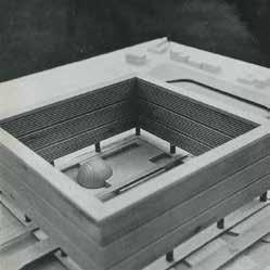
O. M. Ungers. Architectural Design v.61 n.92 1991, 92.
Illustration
or issues in the community that aren’t apparent on the surface, often time ignoring real people’s needs and desires. 3. Cultural and Psychological Layers in Community Engagement
The term can also apply to the more abstract layers in communities— such as the unspoken norms, cultural practices, or shared values that subtly influence behaviour.
3. Developing Across Scales to Implement in the Real World
These hidden cultural layers are often fundamental for inclusive development, as they help to align the goals of formal community development projects with the values and needs of community members.
With a focus on TACTICAL urbanism to reveal and activate the hidden layers for the purpose of community growth and transformation, this studio will operate on a range of scales from the metaphorical and theoretical to the conceptual realm of ideas right down to the physical implementation of portions as test cases in the public realm as tactical community interventions. You will be building interventions on-site in collaboration with the community.
4. Capacity-building and Skill Development
The unseen “layers” represent the training, skill development, capacity-building and knowledge transfer efforts we are going to focus on in the studio that help build momentum and enable individuals from the community through co-creation and collaboration to contribute to the transformation of the community now and into the future. These efforts may be less visible in development but are crucial for long-term sustainability. Building these layers enables communities to self-organize and innovate, much like how neural networks “learn” through hidden layers.

Illustration
El Lissitzky, 1920
SCHEDULE


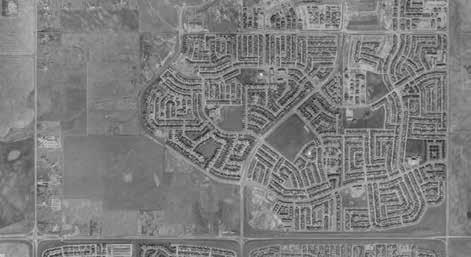
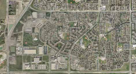
Illustration Google Maps, 2024.

Illustration Google Maps, 2024.
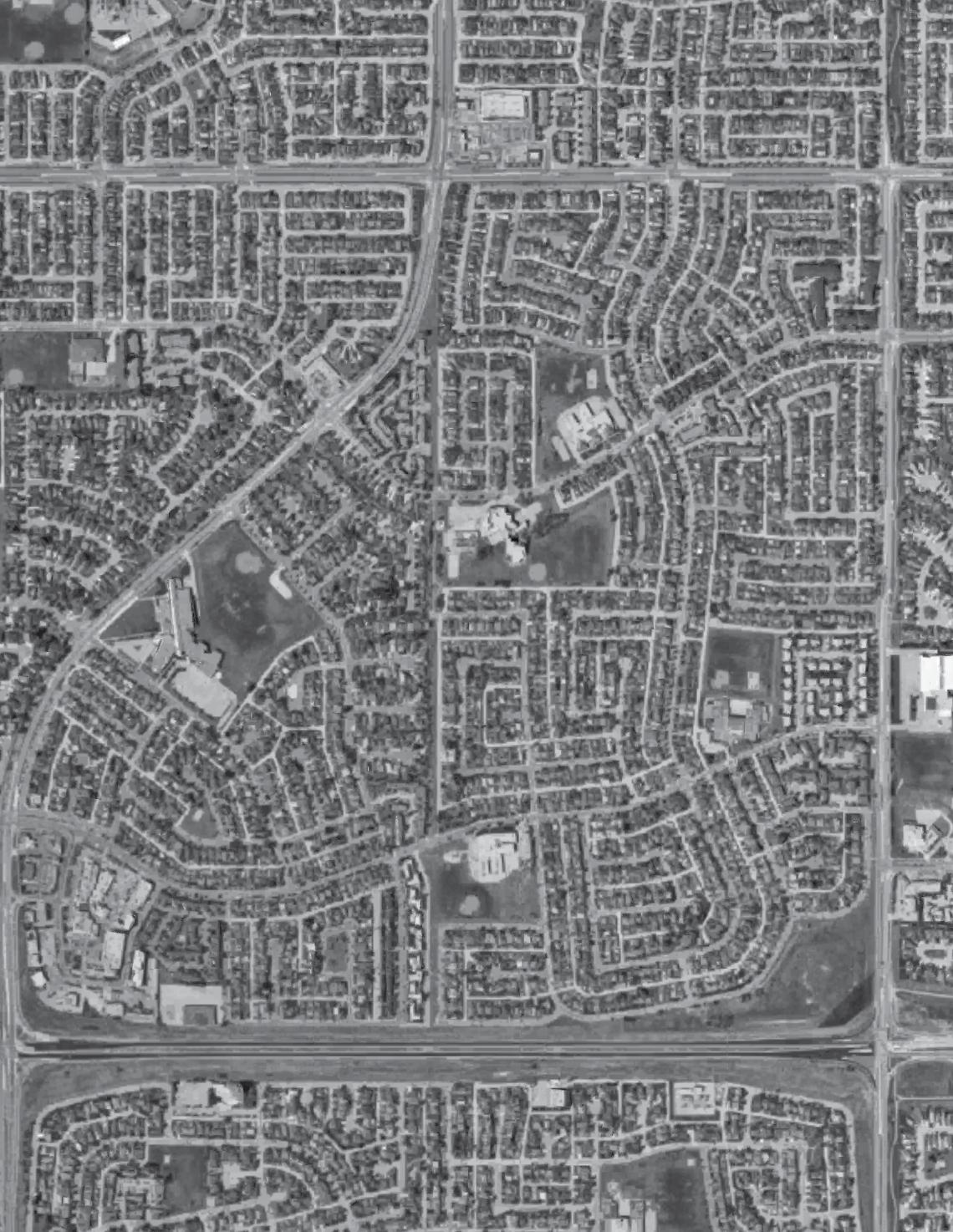


Illustration Google Maps, 2024.

Illustration Township no. 25, range 29 west of fourth meridian, 1885, (CU14015434) by Canada. Dominion Lands BranchBrahazon, S. L.,Ogilvie, William, 1846-1912. Courtesy of Historical Maps Collection, Libraries and Cultural Resources Digital Collections, University of Calgary.
T25 R29 W4


S3NE T25 R29 W4
Illustration
The City of Calgary, 2024. Land Use Distric Map S3NE T25 R29 W4, calgary.ca


Illustration
Gunter Rambow, “Utopie Dynamit” (1976)
Venturi, R., Scott Brown, D. and Izenour, S., 1972. Learning from Las Vegas. Cambridge, Mass. ; London: MIT Press.
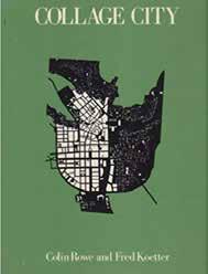
Rowe, C. and Koetter, F., 1978. Collage City. Cambridge, Mass.: MIT Press.
Ungers, O.M., Koolhaas, R., Riemann, P., Kollhoff, H., Ovaska, A., Hertweck, F., Marot, S. and Ungers Archiv für Architekturwissenschaft, 2013. The City in the City: Berlin: a Green Archipelago. Züricha: Lars Müller Publishers.
Aureli, P.V., Tattara, M., Tournaire, J., van de Wijdeven, T. and Pohl, D. eds., 2013. Dogma: 11 Projects. London: AA Publications.
Hofmann, S., 2014. Architecture is Participation: Die Baupiloten - Methods and Projects. Berlin: Jovis.
Venhuizen, H., Landry, C. and Westrenen, F.V., 2010. Game Urbanism: Manual for Cultural Spatial Planning. Amsterdam: Valiz.
READING


The design studio is structured into a series of phases, each with a distinct assignment. These phases are tailored to specific content and input while also facilitating project development by providing a framework for the process. This structure scafolds your learning and project development.
Rather than progressing
PHASES
linearly, the phases interconnect, allowing for iterative feedback and refinement. Although assignments are graded, they serve primarily as milestones rather than standalone outcomes. Their main purpose is to function as progress assessments, offering a snapshot of development at a given stage.
Objective This task draws inspiration from Guy Debord’s 1957 map, The Naked City, which embodies the Situationist International’s concepts of psychogeography and dérive (drifting). The Naked City map fragmented Paris into isolated “zones” connected by arrows that signify flows of movement, emotional resonance, and human experience rather than traditional geographic relationships.
2. Identify Emotional/Experiential Zones: Break down the neighbourhood into zones or “fragments” that hold distinct emotional or sensory experiences. Examples might include: A lively intersection bustling with energy. An abandoned alley that feels eerie or isolating. A serene park offering calm and reflection. A noisy, chaotic street market
Text McDonough, T.F., 1994. Situationist Space. October, 67, pp.59–77.
3. Map the Zones and Flows: Create a visual map inspired by Debord’s Naked City: Represent each zone as a disconnected piece or shape rather than a precise geographic representation. Use arrows to indicate the flows of movement or the paths you followed between these zones. The arrows can also suggest the emotional or sensory pull that guided you (e.g., a smell drawing you into a bakery or a noisy street repelling you). Feel free to simplify the details of streets or landmarks—emphasize experience and movement over accuracy.
Steps 1. Explore Your Neighbourhood Using the Dérive Method: Set out on an unplanned walk or exploration of the neighbourhood. Let your instincts, emotions, or environmental cues (like smells, sounds, or architectural elements) guide your path. Take note of locations that evoke strong feelings, memories, or thoughts— these could be positive, negative, or ambivalent.
4. Incorporate Notes or Visual Elements: Annotate zones with brief descriptions, phrases, or symbols that capture the character of each space. Example: “buzzing with chatter,” “silent and empty,” or “a place of curiosity.” Use a mix of sketches, snippets and elements to match the Debor reference by mimicking colours, textures to convey the atmosphere of different zones (e.g., vibrant colours for lively areas and muted tones for isolating spaces).
Deliverables Naked City map of the community (Arch D), written summary of your and process and reflection on the result (500 words).
Reflection
The final product will be a subjective, fragmented map that visually represents the neighbourhood through your emotional and experiential lens, rather than as a traditional, geographically accurate depiction. By deconstructing familiar spaces and charting psycho- geographic flows, you will offer a fresh, personal understanding of the neighbourhood’s dynamics, uncovering its hidden emotional terrain.
This approach challenges conventional ways of seeing and mapping urban space, aligning with Debord’s intention to reveal how cities influence human behavior and perception.
A01 - Deadline Tuesday, January 28 10% (individual)

Illustration
Guy Debord, 1957. The Naked City: Illustration de l’hypothèse des plaques tournantes en psychogéographique. Lithograph, Encre sur papier, 33.3 x 48.3 cm, 009 05 01, François Lauginie, FRAC Centre-Val de Loire.
Interpret the neighbourhood according to the ‘Green Archipelago’ Concept: Map the Neighbourhood by creating base maps using existing resources (satellite imagery, GIS, hand sketches). Map twelve thematic layers of relevanceyour hidden structures. These can include
1. Conduct Visual and Spatial Analysis
Objective Through a comparative visual analysis, this task focuses on urban morphology (the spatial structure, patterns, and forms). Drawing inspiration from “The Green Archipelago” by Oswald Mathias Ungers and Rem Koolhaas (1977), the focus is to identify key morphological patterns, study their spatial significance, and propose new interpretations for the neighbourhood’s form and use based on reference examples. The Green Archipelago examined the city of Berlin by identifying “islands” of concentrated urban activity within a broader, less-dense future context. These “islands” were defined as distinctive spaces juxtaposed with fragmented or empty areas and reference objects or memories.
2. Re-interpret Key Morphologies and Import Reference Objects Identify Key Morphologies through comparative analysis of form, e.g. compact “islands” of intense urban form commercial hubs, residential blocks, green spaces, parks, and voids. Edge conditions or thresholds where different spaces interact. Interpret the significance of the identified morphologies: What do the dense “islands” or voids tell us about the neighbourhood’s character? How do these spatial patterns influence movement, community interaction, and urban life?
Text Ungers, O.M., Koolhaas, R., Riemann, P., Kollhoff, H., Ovaska, A., Hertweck, F., Marot, S. and Ungers Archiv für Architektur- wissenschaft, 2013. The City in the City: Berlin - a Green Archipelago. Zürich: Lars Müller Publishers.
Base your re-interpretations on relevant urban design and morphology theorists (e.g., Kevin Lynch’s The Image of the City or Jane Jacobs’ ideas on urban density and community spaces). Use references to transform your neighbourhood plan. Find well-known key morphology references that match your reinterpretation. Then, import them into the neighbourhood plan to visualize the new situation you have created.
infrastructure, cultural dimensions or socially functionally distinct elements. Break the neighbourhood into distinct morphological areas based on spatial patterns, density, and form by using a figure-ground analysis (Nolli Plan) that focuses on form and void (e.g. dense clusters of buildings, open or vacant spaces such as parks, derelict lots, unused land, transitional zones, e.g. roads, pathways, edges.
3. Develop Visual Story: Identify four key morphologies Explain each in six steps: Aerial photo, plan, building structure, re-interpretation, reference object, and collage for the aerial view of the re-interpretation.
4. Written Reflection (500 Words) addressing the following: Key Observations: Summarize the neighbourhood’s morphology. What patterns emerged? Which locations were identified as significant “islands” or voids? Interpretation and Meaning: What do the observed morphologies reveal about the neighbourhood’s history, growth, and use? How do voids and islands contribute to urban life and identity? References: Integrate interpretations from theoretical references to support your analysis (e.g., Green Archipelago, Kevin Lynch, or Jane Jacobs). Re-interpretation: Discuss how the neighbour transforms by accommodating the imported objects through adaptation. How have you created a new reading of the community overall?
Deliverables: Mapping of the community (Arch D) thematic layers Visual story in six steps from community map to identification of typology and imported Object with interpretation Written Reflection (500 words)
Reflection
This task challenges you to engage critically with urban morphology, rethinking your neighbourhood’s spatial dynamics with the ideas of The Green Archipelago and broader urban theory. Combining visual mapping and written analysis will offer a nuanced understanding of form, function, and meaning in the urban landscape. The final product will form the basis of a vision for the community.
A02 - Deadline Tuesday, January 28 10% (individual)
Illustration
ARCHIPELAGO

Ungers, O.M., Koolhaas, R., Riemann, P., Kollhoff, H., Ovaska, A., Hertweck, F., Marot, S. and Ungers Archiv für Architektur- wissenschaft, 2013. The City in the City: Berlin - a Green Archipelago. Zürich: Lars Müller Publishers., p.50.
1. Define objectives and focus based on key findings from your individual neighbourhood analysis with “situation” and “archipelago”, e.g. experiential intercommunity connections, morphologies, dense “islands,” underutilized, unprogrammed spaces, community strengths, or emerging challenges. Identify key issues or opportunities that emerged in conversations with stakeholders. Set clear goals for the event
Use physical maps where participants can “pin” or mark the neighbourhood’s problem areas, opportunities, or emotional zones. Use stickers, colour codes, or labels to gamify this activity. Develop role-playing/simulations where participants take on roles (e.g., urban planners, community leaders) and brainstorm solutions to specific neighbourhood issues. Implement voting to create challenges where participants
Objective This task requires you to engage with the local community by designing and hosting a participatory event. The activity you design centers on the key findings and emerging issues identified in your urban analysis (e.g., morphology, community needs, islands/voids, spatial dynamics) and implements a gamification strategy to foster engagement and generate information. The goal is to overlay your analysis with the knowledge, interpretations and ideas the community members have or create during the workshop. The event’s process and outcomes must be documented to reflect learnings, community input, and action points.
2. Develop a Gamification Strategy for your in-person engagement. This involves incorporating gamelike elements (e.g., tasks, challenges, rewards) to make the event interactive, enjoyable, and productive. Select the right gamification tools and game mechanics, e.g. treasure hunt, by encouraging participants to explore key neighbourhood locations identified during the analysis, adding prompts or challenges (e.g., photograph voids, map green spaces, suggest improvements).
and what you hope to achieve, e.g. raise awareness of neighbourhood issues, encourage creative solutions from the community, or promote collaboration and dialogue among residents.
Text Venhuizen, H., Landry, C. and Westrenen, F.V., 2010. Game Urbanism: Manual for Cultural Spatial Planning. Amsterdam: Valiz.
Reflection
earn “points” for contributions (e.g., submitting ideas, mapping issues). Ask participants to form teams and pitch brainstorm ideas for improving the neighbourhood, and “pitch” them to the group in a creative, timed format. Ensure the game structure ties directly to your analysis topics (e.g., spatial fragmentation, urban voids, emerging issues). and develop all the material required to play the game with multiple groups of community participants.
4. Record observations, ideas, and emerging themes shared during the activities. Document the event outcomes by gathering physical artifacts created by participants: maps, drawings, annotations, or notes from the activities. Take photographs or videos of the event to document participation and engagement. Reflect on how the event addressed the themes and issues identified during the analysis. Identify recurring ideas or opportunities that emerged. Deliverables Participation Activity, Facilitation of Workshop, Documentation (letter), Written Summary (500 words), Highlight actionable insights or next steps.
3. Facilitation of Workshop Guide participants through activities and challenges Ensuring everyone has a chance to contribute by creating a collaborative and open atmosphere for sharing by encouraging creativity, collaboration, and fun! Embed the game in phases for clarity and engagement and pay close attention to the timeframe: Welcome and introduction to explain the purpose and goals. Conduct the main Gamified participation activity using your developed game mechanic to facilitate reflections or small group discussions to gather insights. Ensure you have time to summarize key takeaways and outcomes with participants. Prepare materials and tools such as maps, props, game instructions, pens, stickers, scoreboards, or digital tools for interaction.
This task is an opportunity to bridge your analytical findings with community engagement. By integrating gamification, you create a dynamic, inclusive space where residents actively contribute to understanding and improving their neighbourhood. The final documentation will showcase both the process and tangible outcomes, ensuring the voices and ideas of the community are captured and valued.
A03 - Deadline Thursday, February 06 20% (group)
WORKSHOP

Illustration haha... this is so funny
Review key findings from your urban analysis (morphological patterns, voids and islands, flows, connectivity, emerging issues) and incorporate insights and ideas generated during the community event and workshops. Then, articulate a key scenario for future development addressing emerging themes, e.g. improving connectivity and movement, enhancing underutilized spaces, supporting social infrastructure,
Develop before-and-after scenarios to showcase transformations (e.g.,
Use drawings and vignettes to create visual narratives of the proposed future community. Visuals will help stakeholders understand the transformation.
3. Visualize the Future Scenario
How do residents live, interact, and engage with the space?
4. Develop Policy Recommendations
1. Revisit
Insights and
Findings
Objective This task requires you to synthesize insights from previous phases— exploration, analysis, and community workshops—into a coherent vision and proposal for a future development scenario. You will explore opportunities for physical, social, and environmental transformation, visualize the desired outcomes, and provide actionable steps (including policy recommendations). The proposal should reflect a deep understanding of the community’s current condition, its challenges, strengths, and aspirations, translating these into a compelling future scenario.
Consider how the community addresses its challenges in this future scenario. What opportunities are leveraged (e.g., public spaces, cultural assets, infrastructure)?
Describe the community’s physical form, functionality, and character. Highlight its social, environmental, and economic qualities (e.g., vibrant, connected, green, inclusive, sustainable). Map out the steps, actions, and strategies that will lead the community’s transformation to align with the vision.
Develop a vision statement by addressing: What is the community like in the envisioned future?
2. Formulate a Future Vision
encouraging sustainable development and climate resilience, or strengthening cultural identity and local economy.
Text Ungers, O.M., Koolhaas, R., Riemann, P., Kollhoff, H., Ovaska, A., Hertweck, F., Marot, S. and Ungers Archiv für Architektur- wissenschaft, 2013. The City in the City: Berlin - a Green Archipelago. Zürich: Lars Müller Publishers.
Deliverables
Drawings, including maps, plans, and diagrams, showcasing key spatial and morphological transformations. Visualizations (Vignettes): Illustrative perspectives that depict future scenarios of key locations communicating the atmosphere, activities, and users.
Policy Recommendations: A structured set of actionable recommendations addressing spatial, social, environmental, and economic strategies to achieve the proposed vision. Poster format (Arch D).
Reflection
redesigning a park, activating a void, improving street networks). Draw maps to demonstrate spatial changes at different scales. Paint vignettes of detailed illustrations for key locations, such as streetscapes with enhanced walkability, greenery and social spaces, redesigned public spaces with amenities for diverse user groups, and adaptive reuse of buildings for community hubs, markets, or cultural activities. Focus on visual storytelling: Who is using the space? What activities are happening? and include clear, annotated diagrams to explain interventions (e.g., new pathways, green corridors, zoning changes). Use a mix of hand-drawn sketches, renderings, or digital tools (e.g., Photoshop, Illustrator, GIS, SketchUp) to communicate ideas effectively.
Propose strategic actions and policy recommendations to support the vision and ensure the future development scenario is achievable. Demonstrate how proposed elements link to and expand on existing policies for the community and the City of Calgary. Address spatial Interventions to improve land use, activate underutilized spaces, and encourage mixed-use development and recommendations for community infrastructures enhancing public spaces, social infrastructure (e.g., parks, community centers), and accessibility. Proposals for sustainable development include green infrastructure (e.g., tree planting, permeable surfaces), climate adaptation measures (e.g., water management systems, energyefficient design), mobility and connectivity with improved pedestrian pathways, cycling infrastructure, and public transportation systems. Strategies to encourage social and economic inclusion and community participation, local economic development, and cultural preservation. Frame recommendations as actionable and implementable steps that could guide decision-makers, planners, and community stakeholders.
This task encourages you to connect analysis, community engagement, and design thinking to propose realistic yet imaginative future opportunities for the community. Through visual storytelling and actionable recommendations, the project will serve as a guide for envisioning a better future while addressing current issues and community aspirations. You offer a framework for meaningful, sustainable, and inclusive development by testing and illustrating these opportunities.By testing and illustrating these opportunities, you offer a framework for meaningful, sustainable, and inclusive development.
A04 - Deadline Tuesday, March 18 20% (group)
TRANSFORM


Illustration
Gian Ugo Polesello, Aldo Rossi, Luca Meda. Casabella 278 1963, 50
1. Intervention Goals and Site
Reflect on the identified needs or opportunities and focus the purpose on either improving the aesthetics, enhance walkability, safety, activation or similar. Select a site that is easily accessible, relevant to community needs, and manageable within the given time frame. The intervention must be visual, tangible, and temporary, showing what future longterm changes might look like. Choose/ develop a manageable scale and concept corresponding to the defined goals. Ensure the project can be implemented in half a day by your small group. Designed for quick assembly and safe disassembly.
Objective This task focuses on implementing a tactical urbanism intervention—a smallscale, low-cost, and temporary urban transformation that demonstrates how a space could evolve in the future. The intervention will respond to ideas and feedback gathered during the community workshop and reflect immediate, achievable steps to show future transformation today. The project must be designed for quick assembly and disassembly, prioritize safety, and involve hands-on participation from the community and all team members. The outcome should serve as a prototype or demonstration, sparking conversations about long-term changes and inspiring the community to reimagine their public spaces.
Your budget is $200 for each group. Choose materials that are lightweight and portable and possibly reused: Items like wooden pallets, plastic crates, tires, chalk paint, modular furniture, and fabric are easy to transport and install. Ensure all materials are safe and durablesturdy, non-toxic, and weather-resistant for temporary outdoor use. Opt for recyclable or reusable materials. Prioritize Safety throughout the process: Ensure no sharp edges, hazardous elements, or trip hazards are present during construction and use.
4. Evaluate and Reflect Observe how the community interacts with the transformed space. Gather informal feedback on how people use or respond to the intervention and reflect on how the project illustrates the potential for longer-term changes.
2. Implementation Process with Material Selection and Safety Considerations
Use bold, engaging elements to attract attention and communicate transformation.
Implement the intervention on site with a focus on teamwork, efficiency, and safety. Develop a plan to involve the community throughout the process. Document every step through photographs, videos, and notes, e.g. capture before-andafter views of the space, participants actively contributing to the construction, build stages, community reactions and engagement during the intervention and disassembly and recycling.
3. On-Site Construction
Text Ungers, O.M., Koolhaas, R., Riemann, P., Kollhoff, H., Ovaska, A., Hertweck, F., Marot, S. and Ungers Archiv für Architekturwissenschaft, 2013. The City in the City: Berlin - a Green Archipelago. Zürich: Lars Müller Publishers.
Reflection
This task emphasizes the power of hands-on, lowcost urban interventions to demonstrate tangible change. By engaging the community directly in the construction process, you foster ownership, participation, and dialogue about the potential for long-term transformations. The intervention acts as a prototype, showcasing ideas in a way that is immediate, impactful, and reflective of the community’s aspirations.
Deliverables Participatory construction on site Physical, optical and experiential transformation of the location The project should visually communicate a possible future transformation while being quick to assemble, safe, and easy to disassemble. Documentation with reflection (letter)
A05 - Deadline Tuesday, April 15 20% (group)
TACTICAL

Illustration
VALIE EXPORT, “Einkreisung” (1976). (Photo: Ben Westoby. Collection Thaddeus Rope. Courtesy VALIE EXPORT. Bildrecht Wien, 2024)
Introduce the project’s aim and explain the report’s role as a reflection and
1. Introduction, Context and Analysis
Key Components of the Report
Objective The final report is a comprehensive, visually engaging, and accessible document that serves as the culmination of your project. Designed specifically for the community and stakeholders, this report should clearly communicate your findings, processes, and proposals in an informative and visually compelling way. It should act as both a record of the project and a practical guide for future development opportunities, sparking further dialogue, action, and community engagement. The report must balance straightforward narrative storytelling with curated visuals, ensuring it is accessible to a broad audience—community members, decision-makers, and local organizations. Reflection on the journey of the project, along with actionable recommendations, is key to making this a forward-thinking and inspiring document built around visual and design quality.
2. Documentation of Process and Key Phases
Reference: Herzog, J. and Meuron, P. de, 2003. Vision Dreispitz: Eine städtebauliche Studie. Basel: Christoph Merian Verlag.
a future resource for the community. Provide a clear overview of the community and the project context. Summarize the community’s challenges, opportunities, and unique characteristics that the project has addressed. Outline the project’s core goals and how they align with the community’s needs.
3. Reflections Reflect on the process, highlighting lessons learned, challenges encountered, and opportunities uncovered. Questions to address: How did the project evolve, and what insights emerged? What role did community input and tactical interventions play in shaping the outcomes? What were the biggest challenges, and how were they addressed? Use a reflective tone that shows empathy and understanding of the community’s needs. 4. Recommendations for the Future Provide actionable recommendations for the community and local stakeholders to build upon the project. Short-Term Actions: Quick wins or smallscale interventions (e.g., pop-up parks, wayfinding strategies). Long-Term Strategies: Policy
Use curated visuals (maps, diagrams, photos, and drawings) and concise narrative descriptions to document the project phases while summarizing key findings: from your initial observations, including spatial, social, and morphological analyses with annotated maps, spatial diagrams, and photos of site observations. Describe the workshops, events, and interactions with the local community. Highlight community insights, ideas, and key takeaways with photos of workshops, community drawings, and word clouds showcasing recurring themes. Present the small-scale urban interventions from your tactical Interventions implemented during the project and explain how they demonstrated future transformation possibilities and engaged the community. Present your vision for the community, including the final design proposals and recommendations.
A mix of high-quality visuals Printed and Digital Formats
recommendations, spatial plans, and infrastructure improvements. Community Engagement: Suggestions for ongoing participation and collaboration to ensure the community remains involved in shaping its future. Highlight how these recommendations align with the broader community vision established during the project. Deliverables 40-page letter format Final Report: A curated, visually compelling document (analysis, workshops, interventions, and future vision) Reflections on the project journey. Recommendations for shortterm and long-term actions
Reflection
The final report serves as the project’s legacy document, capturing its key ideas, successes, and lessons in a format that inspires action. The report becomes a tool for empowering the community, engaging decision-makers, and shaping future development by combining straightforward narrative storytelling, visual richness, and practical recommendations.
A06 - Deadline Tuesday, April 22 20% (group)


Illustration coop himmelb(l)au, 1991. Tempo, Potsdamer Platz, Berlin, Germany 1990. Architectural Design v.61 n.92, 24.

