

Location: Wuhan, China
Architect: Sasaki
Area: 4450 Acres
The rapid expansion of China’s High Speed Railway network has been instrumental in driving economic growth throughout the country at both the city and regional scale. Evidence of this initiative’s success is the pairing of the Wuhan High Speed Railway station and the new Yangchun Lake Business District. Designed by Sasaki in collaboration with a diverse interdisciplinary team including Arup, JLL, and the Wuhan Planning & Design Institute, the master plan was recently approved by the city, marking a major step forward as Wuhan embraces a progressive yet realistic vision for the district.

(Source:https://www.sasaki.com/projects/wuhan-yangchun-lake-business-district/ )
1. The first strategy was the naturalization of the existing canal network throughout the district, along with the ongoing implementation of the wetland park. The formerly channelized waterways are restored to mimic natural processes.
2. Second, a strategy of constructed wetlands along the lake’s edge filters urban runoff while providing critical habitat for a variety of avian, amphibian, aquatic, and terrestrial species. Designed with a series of boardwalks and trails that link to other recreational pedestrian routes throughout the district, the wetland establishes contiguous public access along the once privatized waterfront.
3. The third strategy was the creation of an extended East Lake Greenway system throughout the entire district that follows existing drainage patterns and major roadways.
4. Fourth, a series of pocket parks are interspersed in each of the district’s neighborhoods, allowing for all residents to live within a 10 minute walk of a public landscape.

5. The fifth strategy was the creation of a new central park. Built upon a former solid waste landfill, the central park re-purposes this once noxious use into a vibrant recreational and ecological amenity.

 Master Plan of Wuhan Lake District
Location: Wuhan, China
Architect: Sasaki
Area: 4450 Acres
• Smaller urban blocks promote walkability and arcades facilitate pedestrian connectivity to the central park.
• Buildings are organized to take advantage of views and to create landmarks within the district
• Urban blocks that radiate outwards from the central park prioritize pedestrian connectivity, linking the outer neighborhoods to the commercial core.


• Most of the open space are contiguous, linked by a network of pedestrian alleys, arcades, and linear parks. Diverse landscapes within the neighborhoods may include pedestrian food streets, shaded recreational spaces, rain gardens and bios-wales, urban agriculture atop podiums, and community roof terraces.
• Different clusters of CBD’s across the area which also connecting each other through a corridor which acts as an landmark within itself and also bifurcates the congestion of traffic and easily accessible from every place.
• Instead of an central green open spaces they have adapted a more organic manner which gives balanced green spaces in all areas easily accessible and creating a natural sponge which prevents flood and ecological balance.

(Source:https://www.sasaki.com/projects/wuhan-yangchun-lake-business-district/ )


Location: Ho Chi Minh City, Vietnam
Architect: Sasaki
Area: 1600 Acres
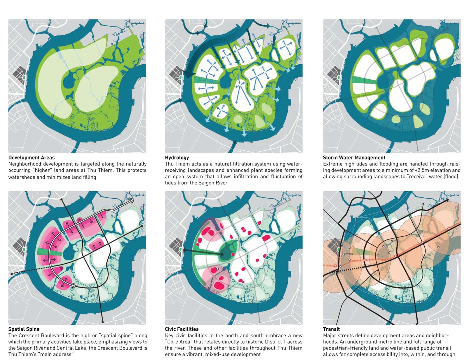
Thu Thiem is located on a 647-hectare peninsula across the Saigon River from the historic center of Ho Chi Minh City. Sasaki’s master planning work for Thu Thiem spans nine years—from 2003 when Sasaki won first prize in an international design competition to ongoing work through 2012 for the Investment and Construction Authority of Thu Thiem. Sasaki’s master plan focuses on development of Thu Thiem as a sustainable, dynamic, mixed-use central business district. The plan is based on a framework of transportation, land use, and public spaces that integrates the existing ecological conditions of the lower Saigon River and responds to the climate of southern Vietnam.

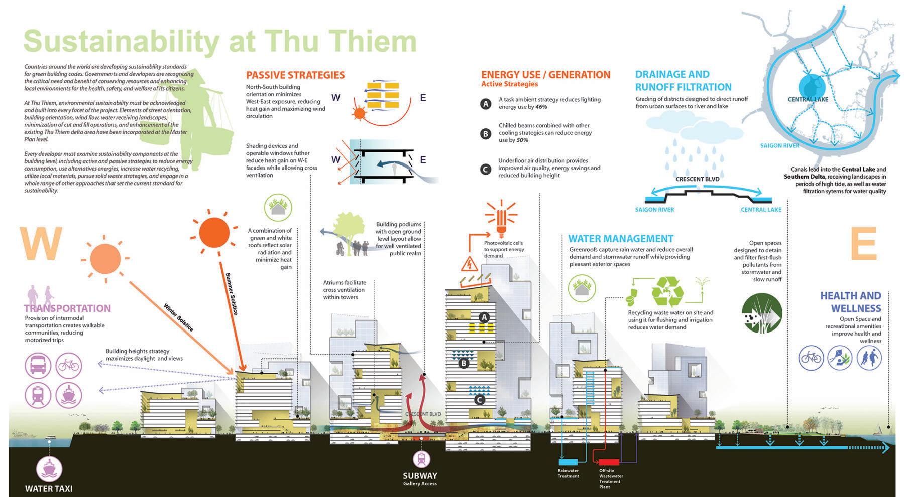
Sasaki’s plan for Thu Thiem also focuses on connections to the riverfront, linkages to the historic city center, and a compact, flexible urban form. The plan promotes density, integrated public transit (waterand land-based), and appropriate street and building orientation that encourages cross-ventilation and passive cooling. The plan incorporates the natural delta landscape and river fluctuations into the urban fabric and preserves native vegetation. A key ecological strategy is maintaining Thu Thiem as an “open system”—one that accommodates tidal regimes and high-water events through natural and man-made canals, lakes, and mangrove areas. All residential areas are in close proximity to the water and to the public spaces created through this strategy.
• Green around the built concept is used where the built is built like an island surrounded by green spaces.
• The central Core areas of mixed use development are spreaded in a balanced way with a proper transit network this will help to enhance the vibrancy of the project in homogeneous way also creating varied economical scopes within itself.
• Networks are laid which emphasize on radial form with large block size and central network passes through each of the block for better accessibility.
(Source: https://www.sasaki.com/projects/thu-thiem-new-urban-area/)

Location: Ho Chi Minh City, Vietnam
Architect: Sasaki
Area: 1600 Acres
Sasaki’s plan for Thu Thiem also focuses on connections to the riverfront, linkages to the historic city center, and a compact, flexible urban form. The plan promotes density, integrated public transit (water- and landbased), and appropriate street and building orientation that encourages cross-ventilation and passive cooling. The plan incorporates the natural delta landscape and river fluctuations into the urban fabric and preserves native vegetation. A key ecological strategy is maintaining Thu Thiem as an “open system”— one that accommodates tidal regimes and high-water events through natural and manmade canals, lakes, and mangrove areas. All residential areas are in close proximity to the water and to the public spaces created through this strategy.

Over the next 20 years, Thu Thiem will accommodate over 130,000 residents. Since 2005, three major infrastructure linkages have been built based on Sasaki’s planning work. The Thu Thiem Bridge connects Thu Thiem directly with the existing city to the north. The East-West Highway—aligned in accordance with Sasaki’s original Master Plan—has also been constructed, connecting Thu Thiem to residential and commercial districts to the east and opening up access to diverse development opportunities. The completed East-West Tunnel passes below the Saigon River and connects historic District 1 and Thu Thiem. In the future, an iconic pedestrian bridge will connect Thu Thiem’s Central Plaza— which will be one of the biggest public spaces in all of Vietnam—with Me Linh Square on the west side of the river.

• TOD networks are established around the main spine of road. This network joins all the neighbourhood in the loop which is created which makes it much easier to commute and tries to eradicated complications of multiple para transits.

(Source: https://www.sasaki.com/projects/thu-thiem-new-urban-area/)


Location: Ho Chi Minh City, Vietnam
Architect: Sasaki
Area: 1600 Acres
(Source: https://www.sasaki.com/projects/thu-thiem-new-urban-area/)