3 minute read
Avernakø (island

garlanded with beech branches and spring flowers every Saturday in Pentecost. On your right, you pass several small ponds. If you come along in the spring, you may be lucky to hear the croaking of the rare fire-bellied toad. Skalle road leads to the village of Munke with the beautiful monks farm, which is reflected in the village pond. Turn right onto the main road. About one kilometre off the main road you reach the Turnpike. Until 1937 Avernakø was two islands that were ‘linked’ by an approximately 700 m long causeway between Avernak and Korshavn. During the economic crisis of the 1930s, as part of maintaining employment, money was granted for the construction of this embankment between the two
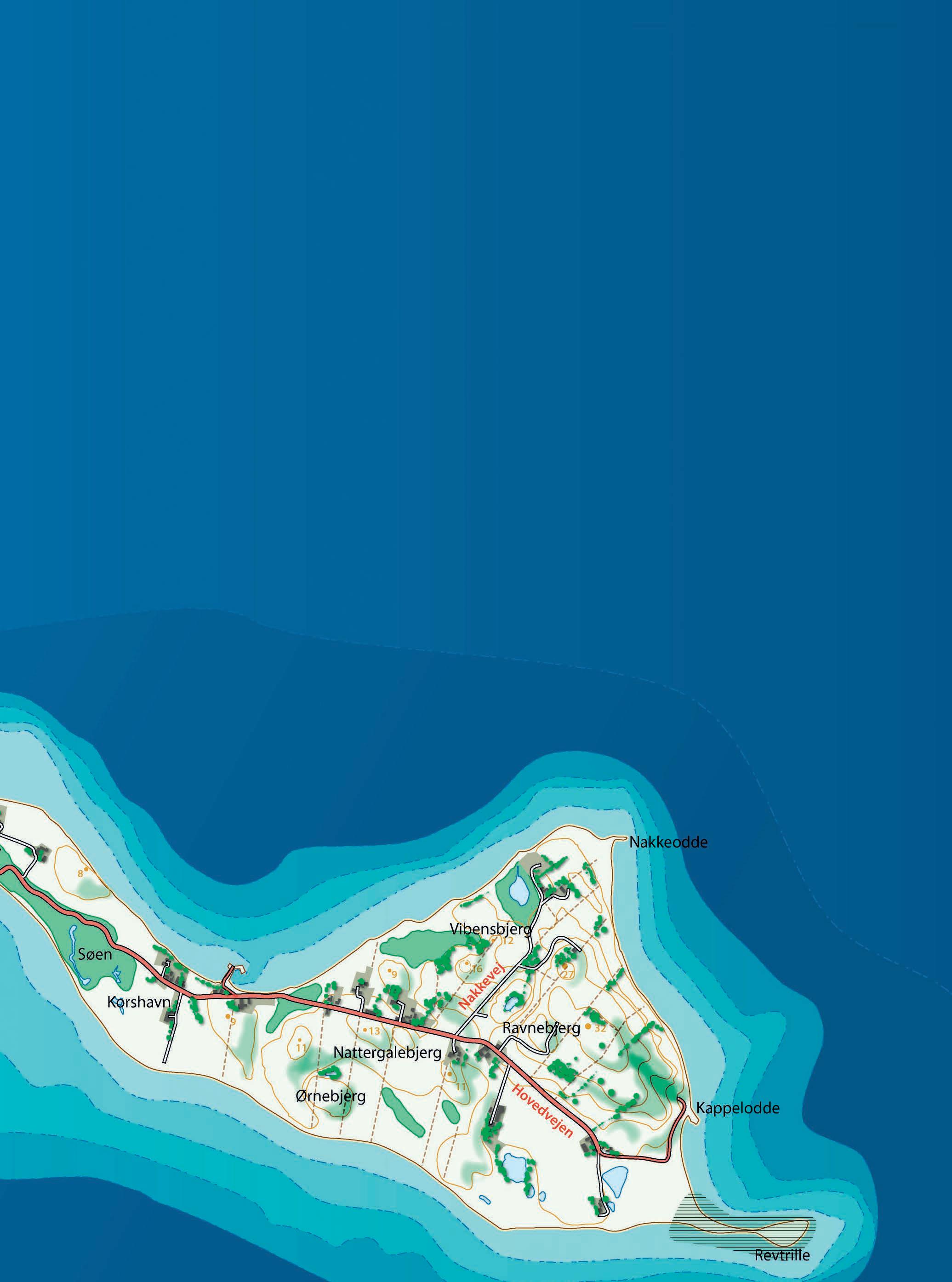
Avernakø is located six kilometres from Faaborg and consists of two islands – Avernak and Korshavn – which were connected with a causeway called The Turnpike in 1937. The island is eight km long and has a coastal circumference of nineteen kilometres. You arrive at Avernakø at the west end of the island where there is a harbour café, which is a good place in summer to wait for the ferry or to take some refreshment. From the ferry dock there is only one road and it leads to Avernak village. Turn right at the Skalle road. Here stands one of
Avernakø’s maypoles. The maypole has gradually become Avernakø’s landmark. The maypole is a symbol of fertility from pagan times - a prayer to the gods to have a good harvest in the field. Today it functions as the island’s official flagpole. When exactly it arrived Avernakø is lost in the past, but the traditions are continued in Avernak village and in Munke, where the maypole is islands. Throughout the years many people have drowned when they have tried to cross the Turnpike in stormy weather.’Through common enterprise The Turnpike became a roadway’ are the words that
Distance 16 km (Avernakø is 8 km long) Beautiful eventful trip with great views of the archipelago.
Difficulty: There are not many inclines and not many cars. The roads are narrow and asphalted.

Suitability for children: The trip is good for children, offering many possible experiences, places to relax and nice bathing areas.

stand on the memorial stone there, marking the unity and development between the two island communities. Welcome to Korshavn where there are two major shipwrecks from ancient times. Unfortunately they were not preserved - and are now part of the embankment. Korshavn jetty is a small harbour that is an ideal place in which to rest and if the weather is suitable, the main road ends at Kappelodden where there is a good but deep bathing beach. You cannot now go any further east - so turn your bike around. The way back is again along the highway. However, you can take a detour along Nakkevej and all the way to Nakke Odde, which is a child-friendly wide, sandy beach. Back over the Turnpike, on through Munke and on past Avernakø Church. In the church you can pause, and among other things, see copies of the six gold bowls with solar symbols that were found on the island in 1685. Shortly before Avernak village you will
find the island’s old school, which today is a country hotel, as well as the island’s grocery store. The main road leads through the village, past the island’s summer house area and returns to the ferry dock. Avernakø means ”The place where the eagle lives” (originally Ar-nache which is composed of Ar = eagle, nache = neck / place).


